Embed Size (px)
Citation preview
1Austin Transportation Department | austintexas.gov/transportation
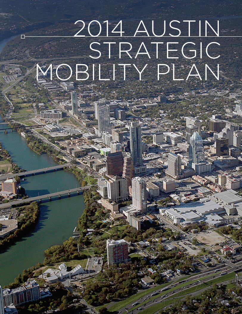
2014 AUSTIN STRATEGIC
MOBILITY PLAN

2Austin Transportation department | austintexas.gov/transportation
THE GROWING NEEd FOR TRANSPORTATION SOLUTIONSThe City of Austin is attracting new private sector investments, adding jobs and welcoming thousands of new residents. Austin has been consistently ranked in national publications as a top performing city for attracting jobs. The City of Austin demographer estimates that on average, 110 people are moving to Austin each day, supporting a trend of long-term, sustained, rapid population growth. In fact, Austin has led the top 30 US Metro areas in population growth from 2010-2011, and has been consistently one of the top 10 fastest growing metropolitan communities for the last decade, according to U.S. Census data.
This growth brings many benefi ts, but also presents challenges. As the 11th largest city in the U.S., Austin is experiencing signifi cant travel congestion issues that will only increase as the region continues its rapid expansion. More people, going to more jobs, equals more cars on the road. This economic expansion has created traffi c congestion throughout the city. Even with a renewed sense of urgency and regional cooperation, Central Texas is still growing too fast for our transportation system to keep up. Traffi c grew more than 30 percent faster than the growth in road capacity in the Austin metro area over the past 25 years, according to a 2009 Texas Transportation Institute report.
Consequently, Austin is also known as the 4th most congested metropolitan area in the United States, according to Inrix, a national transportation research fi rm in its 2014 Traffi c Scorecard. The congestion measure is based on the average commuter travel time during peak periods, as compared to free-fl ow conditions.
austin Regional Population growth:
4 Milllion Residents
Growth 2010-2040
VMT(Vehicle Miles Traveled)
Annual Hoursof Delay
Annual Costof Congestion
1.7 Million Residents
585,000 Residents
2020
2040
2000
2010
1990
1980
138%
283% 1,037% 2,356%
Growth 1980-2010
191%
US Census data
TTI Travel data
$austin Metropolitan growth impact on travel - 1980-2010:

3Austin Transportation Department | austintexas.gov/transportation
REGIONAL/LOCAL PLANNING
How will we manage this challenge? The region has developed long term plans to accommodate growth in a way that mitigates the mobility challenges noted above. For example, the Capital Area Metropolitan Planning Organization (CAMPO) identified areas of “preferred growth” known as activity centers with a proposed transportation system to serve these centers. In support of that effort, the City of Austin, through its comprehensive plan “Imagine Austin,” set the framework for a “Compact and Connected” approach to promote development in compact centers, communities, and along corridors that are connected by roads and transit with interconnected development patterns and density to support public transit and a variety of transportation choices.
Our region will continue to grow. With these plans, and the associated transportation networks to support the plans, Austin is striving to manage its growth in a sustainable fashion. Our transportation investments must be designed to support Imagine Austin’s “Compact and Connected” vision. Solutions to mobility require a multi-modal system that works seamlessly to provide transportation options, address congestion, and increase mobility throughout the community while supporting and enhancing economic development opportunities within the established “centers.”
AddRESSING OUR TRANSPORTATION CHALLENGES WITH INFRASTRUCTURE
The region’s transportation providers have invested in transportation projects aimed to improve our mobility system. In fact, approximately $5 billion has been spent on roadways within our region since 2000. A few of the more recent infrastructure projects that have been completed, or are underway, include:
• I-35/51st Street Interchange (Funded: City of Austin)
• MoPac/Ben White Interchange (Funded: City of Austin & TxdOT )
• Oak Hill Y Intersection Improvements (Funded: City of Austin, Travis County, TxdOT, CTRMA)
• MoPac Express Lanes (Funded: CTRMA/Regional Infra Bank)
• MoPac at Slaughter and LaCross Interchanges (Funded: TxdOT)
• US 290 Manor Expressway (Funded: CTRMA)
• US 183 Freeway/Bergstrom Expressway (Funded: CTRMA and TxdOT)
• Oak Hill Parkway (Funded: CTRMA)
• MetroRapid Bus Rapid Transit - BRT Route 801 (Funded: Capital Metro, City of Austin, Federal Transit Administration FTA)
• MetroRapid BRT Route 803 (Funded: Capital Metro, FTA)
• Expanded MetroRail Late Night and Weekend Service (Funded: City of Austin)
• SH 71 Express (Funded: TxdOT)
• SH 71/FM 973 Interim Improvements (Funded: TxdOT, City of Austin, Travis County)
Even with these investments, the mobility challenges continue to increase. Per Council’s direction, staff has developed a Mobility Plan that proposes building on past investments.

4Austin Transportation Department | austintexas.gov/transportation

5Austin Transportation department | austintexas.gov/transportation
AUSTIN STRATEGIC MOBILITY PLAN 2014
There is no one answer or “magic bullet” to solve the region’s mobility issues - we must work together to improve mobility with a variety of solutions. In order to sustain Austin’s vitality with ground transportation access and options, the City is implementing strategies to simultaneously invest in projects, such as completing the highway network that enhance vehicle moving capacity around the region’s core, allows through trips to bypass the core, and by focusing on moving people into and out of the congested regional core on effi cient roadways and transit.
Austin Strategic Mobility Plan (ASMP) Guiding Principles
The City of Austin seeks to add new capacity to the transportation network in all modes to alleviate some of the symptoms of growth, and pair it with better information systems to allow residents to make informed decisions about how and when they travel. The ASMP 2014 brings forward projects of regional signifi cance that seek shared solutions and build on previous strategic mobility plans.
Simultaneously invest in projects that enhance vehicle moving capacity around the region’s central core, allowing through-trips to bypass the core.
Invest in projects and policies that increase people moving capacity into the central core, primarily focused on commuter trips, by maximizing traveler choice.

6Austin Transportation Department | austintexas.gov/transportation
Seeking Shared Solutions
Community ground transportation - the movement of people, goods, and services along local collector streets, arterials, highways, freeways, tollways, express lanes, and dedicated transit ways – must fully embrace an integrated, multi-modal system in order to meet the needs of a growing, highly urbanized region. Interdependent modes of transit are necessary to efficiently move people, goods, and services within the community. For example, a commuter may get in a personal vehicle to drive from his or her home to a park-and-ride facility, board a train or commuter bus to travel into the downtown core, and then walk a few blocks to work. This commuter does not view this as several independent/discrete trips, but as one trip from his/her home to work. Without an integrated, balanced transportation network that provides transportation choices, our mobility challenges will become unmanageable. Roads, rail, trails, bus, bike, and pedestrian modes must all be present and work together within the broader “community ground transportation” system to facilitate the region’s growth. Therefore, we must reinforce partnerships to construct regionally significant infrastructure capacity investments in both roadways and high capacity transit options that focus on moving people and goods efficiently, leveraging Austin’s investments.
Building on previous mobility investments• 2010 Strategic Mobility emphasized arterial efficiency with signal investment, bikes/
pedestrian network expansion, and funded I-35 Corridor development Program.
• 2012 Strategic Mobility Proposal added limited new roadway capacity, including investments on I-35 and to the Guadalupe/Lavaca BRT corridor and funded arterial corridor programs.
• Regional partnership funding with TxdOT, Capital Metro, Counties, Central Texas Regional Mobility Authority, etc.
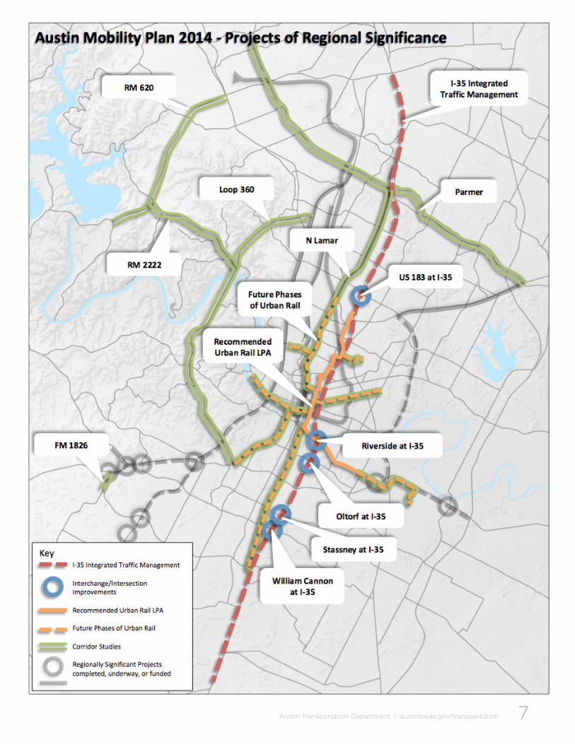
PROjECTS OF REGIONAL SIGNIFICANCE
The Austin City Council is currently considering mobility projects of regional significance that might be incorporated into a proposed mobility bond for November 2014. The City Council directed staff in december 2013 to present to Council a Locally Preferred Alternative for High Capacity Transit serving the Austin Core Activity Center for consideration in the Spring/Summer 2014. Subsequently, Council directed staff to propose potential road and highway improvements, that are consistent with the values set forth by the City Council in the Imagine Austin Plan. The following package of High Capacity Transit Urban Rail and Roadways of Regional Significance are recommended by staff for funding consideration.
Funding
Costs to construct the projects of regional significance noted above assume full funding from the City of Austin. That being said, as the partnership with TxdOT continues to develop, some of the local funding could very well be offset by other sources allowing more projects to be completed. City staff will continue future funding discussions with TxdOT and our other regional transportation partners.
7Austin Transportation Department | austintexas.gov/transportation

8Austin Transportation department | austintexas.gov/transportation
of trips using I-35 within the Austin region are local to the Travis, Hays, Williamson, Bastrop and Caldwell area
85%
SH 45N to SH 45SE
Mobility 35: Capital Area Corridor
The I-35 corridor through central Austin ranks in the top 25 worst congested corridors in the nation, according to Inrix. The portion of I-35 through downtown Austin, which carries more than 200,000 vehicles a day, was ranked as the most congested roadway in Texas in 2013 by the Texas Transportation Institute (TTI).
The City of Austin has been focused on delivering near-term strategies to improve I-35 through Austin that offer to move more people and freight into and out of our region. Toward this end, Austin Transportation has represented the City of Austin since 2010 in working with the Texas department of Transportation (TxdOT) on Mobility 35. This is a comprehensive TxdOT effort to select the best strategies to improve I-35 statewide. Mobility 35 includes multiple roadway segments in Travis, Hays and Williamson Counties; together they make up the “Capital Area Improvement Corridor.” I-35 Capital Area Improvement Program (CAIP) is a partnership of the City of Austin and TxdOT. To improve travel conditions throughout the Central Austin Region.
i-35 CaiP goals:
• Increase capacity
• Better manage traffi c
• Enhance safety
• Optimize existing facility
• Minimize additional right-of-way needs
• Improve east-west connectivity
• Improve compatibility with neighborhoods
• Enhance bicycle, pedestrian and transit options
local trips on i-35 Since 1962, Interstate Highway 35 has been the transportation backbone of the region, connecting central Texas to the rest of the U.S., Mexico and Canada. Today I-35 is congested with three different kinds of trips: long-distance/freight, commuter, and local. The corridor (and its central Austin segment) is routinely ranked as one of the most congested roadways in the region and Texas. Yet 85% of trips within the Austin region are local to the 5-county area - 2013 TTI report.

9Austin Transportation department | austintexas.gov/transportation
i-35/US 183 N
Connect North to East Ramp pairs to provide direct access to US 183, resulting in a bypass of future downtown construction projects
Preliminary OnlyNot a bidding document
leveraging Funds – the Next investment
Austinites approved $3.4 million in 2010 and $15.6 million 2012 bonds to directly address I-35 via corridor development, preliminary engineering, design and construction. Following the City’s initial contribution in 2010, regional partners have invested a total of $61M ($46M from the State) to advance the I-35 program. This leveraging represents an approximate 17 to 1 return on the City’s initial 2010 investment of $3.4 million.
The I-35 Corridor Implementation Plan going forward identifi es keystone projects that must be accomplished fi rst in order to make room to add additional lanes and possible express transit, and to enable downtown reconstruction. Each of these keystone projects are benefi cial as stand alone projects, even if future added capacity via the Future Transit Corridor on the I-35 main lines is not constructed. They each reduce traffi c independently, but as a system provide even greater benefi ts. Local investment in these keystone projects would be expected to attract state and regional funding partners to make complimentary investments. Keystone projects for interchanges and access roadways along I-35 include:
• US 183 Fully-Directional Interchange Completion: This project would connect the north to east ramp pairs, providing direct access between North I-35 and US 183. The resulting project would allow trips traveling to/from Williamson and North Travis County to easily access the US 183 corridor, which is currently funded for reconstruction to provide full access controlled freeway travel corridor between I-35 north and SH 71 on the south. Completion of this interchange would open a viable bypass route of downtown Austin for trips traveling through the Central Austin Region. A bypass route to central downtown Austin, allowing through-trips to avoid delays, is critical if future reconstruction of I-35 in downtown is to be realized. The estimated cost for this project is approximately $120 million. However, because this project ultimately feeds the funded US 183 project soon to be under construction, it is a strong candidate for alternative funding options (e.g., state or regional funding).
10Austin Transportation Department | austintexas.gov/transportation
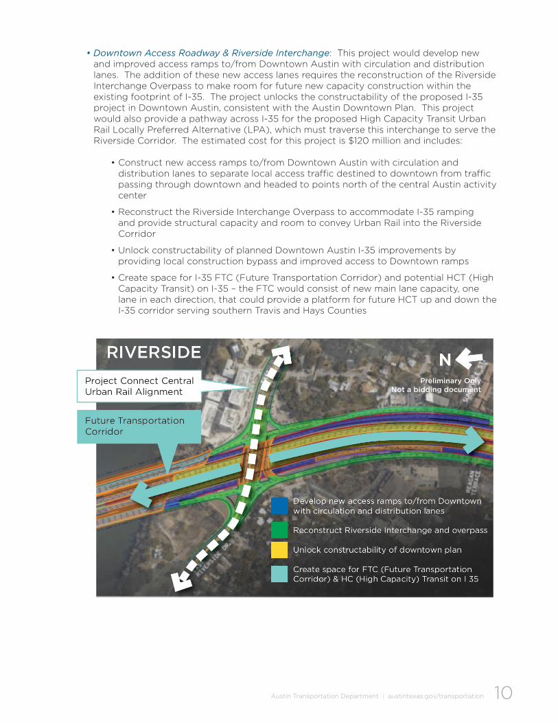
• Downtown Access Roadway & Riverside Interchange: This project would develop new and improved access ramps to/from downtown Austin with circulation and distribution lanes. The addition of these new access lanes requires the reconstruction of the Riverside Interchange Overpass to make room for future new capacity construction within the existing footprint of I-35. The project unlocks the constructability of the proposed I-35 project in downtown Austin, consistent with the Austin downtown Plan. This project would also provide a pathway across I-35 for the proposed High Capacity Transit Urban Rail Locally Preferred Alternative (LPA), which must traverse this interchange to serve the Riverside Corridor. The estimated cost for this project is $120 million and includes:
• Construct new access ramps to/from downtown Austin with circulation and distribution lanes to separate local access traffic destined to downtown from traffic passing through downtown and headed to points north of the central Austin activity center
• Reconstruct the Riverside Interchange Overpass to accommodate I-35 ramping and provide structural capacity and room to convey Urban Rail into the Riverside Corridor
• Unlock constructability of planned downtown Austin I-35 improvements by providing local construction bypass and improved access to downtown ramps
• Create space for I-35 FTC (Future Transportation Corridor) and potential HCT (High Capacity Transit) on I-35 – the FTC would consist of new main lane capacity, one lane in each direction, that could provide a platform for future HCT up and down the I-35 corridor serving southern Travis and Hays Counties
Preliminary OnlyNot a bidding document

11Austin Transportation department | austintexas.gov/transportation
• Oltorf, Stassney, and William Cannon Overpass and Interchange Replacements: These projects would reconstruct the frontage road access and intersections at each of these critical arterials, replacing the existing arterial overpasses, adding U-turn structures, widening the clearance for and relocating the I-35 main-lanes, and making other safety improvements. These projects would provide improved non-vehicular access across the freeway as well as make room for the FTC (Future Transportation Corridor) that is planned to add additional capacity within the existing I-35 footprint. The FTC would provide a platform for future High Capacity Transit (HCT) that could serve southern Travis and Hays Counties. The estimated cost of construction for these interchange replacements combined is approximately $90 million. These projects offer opportunities to partner with TxdOT and other regional transportation agencies to realize their construction.
Each of these I-35 projects individually will reduce congestion, but the sum of the projects provides a greater anticipated benefi t. These projects also create space for the Future Transportation Corridor (FTC) that is planned to add additional capacity on the main lanes of I-35.
• Regional Transportation Management and I-35 Integrated Corridor Management The City of Austin is focused on better managing the entire regional transportation system
and is seeking to integrate freeway and arterial management to improve traffi c throw throughout the urban arterial system. This requires better data within the City’s arterial system, improved signalization, and on-going partnerships with both area highway and transit operating agencies. A new regional transportation management center, with improved and expanded technologies, would initially focus on the I-35 Corridor with Integrated Corridor Management (ICM) strategies to better manage peak hour traffi c fl ow, construction activities, crash and weather related diversions, and special event surges with state of the art technologies. Improved signalization and traveler information systems on surrounding parallel and feeder arterials would also be important tools to fully achieve the ICM strategies. Estimated cost of this project is $30 million. Technology objectives would include:
• Integrate corridor and incident management with ongoing 24/7 operations oversight
• Provide a multi-agency response to daily, construction, or incident related travel delay
• Optimize arterial, transit, and freeway networks with improved signalization to “level the load,” deploying and using smart technologies to monitor and inform travel behavior
• Construct new signals and replace obsolete equipment to maximize the effi ciency of the regional arterial system, reduce traffi c congestion and increase signal system responsiveness
• Improve integration, management and operations of regional traffi c signals, dynamic message signs, traffi c cameras, detection systems, travel time monitoring equipment, and volume count stations across jurisdictional boundaries
Preliminary Only - Not a bidding document
NOltORF StaSSNEy wM.
CaNNON
Future Transportation Corridor

12Austin Transportation department | austintexas.gov/transportation
• Provide actionable pre-trip and enroute traveler information via mobile devices and dynamic message signs about traffi c conditions, roadway closures, incidents, and events
Multi-modal Regional Roadways that address congestion, and facilitate long-term transit investments, include:
• SH 71 Direct Connectors to ABIA, which will enable faster access to the airport for automobiles while also constructing portions of track bed, structures and drainage necessary for a future Urban Rail extension. TxdOT is currently improving the SH 71 corridor and proposes direct access ramps to ABIA from SH 71. The connection would greatly reduce anticipated traffi c congestion within the SH 71/US 183 interchange caused by the confl uence of regional travel streams with traffi c destined to/from the ABIA terminals. This multi-modal project will include accommodation for elements of the track bed and environmental control systems to accommodate future rail extensions to the airport with minimal additional costs. Since the 2014 Austin Strategic Mobility Plan contemplates the construction of an Urban Rail system within the Riverside Corridor, terminating at approximately Grove Street (located to the west of ABIA TxdOT project) and the Project Connect System Plan calls for an extension to the regional airport, part of the funds for this project will be allocated to accelerate the feasibility analysis for connecting the existing proposed Urban Rail line in the Riverside Corridor to ABIA. This work would confi rm alignment assumptions and requirements so that cost effi ciencies with the TxdOT project could be maximized (The proposed budget for this effort is $81.5 million).
• US 183/Riverside Interchange, as part of the SH 71 direct Access Ramp Project to ABIA, a new grade separated overpass and interchange would be constructed at US 183 and Riverside drive. This overpass would remove turn confl icts at the existing intersection and provide structure for a future Urban Rail extension to ABIA (The anticipated cost for this element is estimated at $34 million).
Not for construction
SH 71 DiRECt CONNECtORS tO abia
Proposed SH 71 direct ramps and US 183/Riverside interchange
Proposed future Urban Rail extension
N

13Austin Transportation Department | austintexas.gov/transportation
Regional Safety and Mobility, Corridor Development and Preliminary Engineering (including Project Connect Next Corridor Studies), for key regional roadways that experience congestion, traffic safety and have multi-modal mobility needs.
• Loop 360 Corridor Development Project (SH 71/290 to Loop 1 North): The proposed project represents a partnership project with TxdOT and others to conduct an open and meaningful public engagement process, work with corridor stakeholders to identify safety and congestion issues within the corridor, identify and design short-, mid- and long-term safety and mobility mitigation solutions to existing corridor constraints. This project will address the significant community concerns previously raised by residents in the corridor and seek solutions that would incrementally address overall safety and mobility challenges (The proposed budget for this effort is $10 million).
• RM 620 and RM 2222 Corridor Development Project (Lakeline Area to Steiner Ranch and Four-Points to Loop 360): This project would consider the mobility needs on the western edge of Austin, evaluating the safety and congestion needs within the RM 620 and RM 2222 corridors. Each of these two roadways are today characterized as major urban arterials, operated and maintained by the TxdOT. development pressures and environmental concerns have affected their original planned configuration, resulting in substantial congestion at key intersections, and a lack of alternative routes and travel options. The corridor development project will work with local stakeholders to define the most critical issues, identify a range of alternatives, and recommend a preferred approach for future regional consideration. This study will examine both land use options that might be employed to alleviate future problems as well as examine both roadway and transit options for this part of the city. It would include an extensive public engagement process to assist in the identification of issues and the range of viable solutions. The City of Austin would seek participation from both TxdOT and Travis County (The proposed budget for this effort is $13 million).
• FM 734 Parmer Lane Corridor Development Project and Safety Program (Approximately Avery Ranch Road to US 290): The proposed corridor development and safety program would examine the entire extent of Parmer Lane within the City of Austin to identify and address where possible safety and congestion issues requiring near- and mid-term resolution. The program would seek to preserve the long-term ability of this corridor to efficiently convey the movement of goods and services as well as provide commuter transit options for residents adjacent this important north Austin corridor. The program would include a robust public engagement process to assist in the identification of issues and the range of viable solutions (The proposed budget for this effort is $5 million).
• RM 1826 Corridor Safety Program (Slaughter Lane to US 290): The City of Austin, in partnership with Travis County, TxdOT, the Central Texas Mobility Authority and Capital Metro is currently investing in interim safety and mobility improvements to the US 290/SH 71 corridor in the vicinity of the Oak Hill Y. As an extension of these projects, the proposed RM 1826 safety program will examine existing and developing safety and mobility issues in this short corridor that feeds into the Oak Hill Y. Projects to identify the immediate safety issues that can be funded within the available safety program will be implemented. Long term projects requiring expanded funding will be identified by the City as potential partnering opportunities for future leveraged funding agreements with regional transportation providers (The proposed budget for this effort is $8 million).
• Lamar Boulevard Development and High Capacity Transit Feasibility Program (Riverside to US 183): Portions of Lamar Boulevard are identified by the state as being among the top 100 most congested roadways in the state. The City of Austin, through the 2010 Mobility Bond, funded a corridor development program for North Lamar (north of US 183). As part of the 2012 Mobility Bond, Austin voters approved a similar corridor development program for South Lamar (south of Riverside drive). The City is also in the process of initiating a Guadalupe Street/West Campus Corridor Program to identify mobility projects

14Austin Transportation Department | austintexas.gov/transportation
that could improve east-west connectivity to the University as well as travel north-south through the district. The proposed Lamar Boulevard Corridor development Program would examine opportunities to improve total mobility on the central portion of the Lamar Corridor, connecting with the recommendations identified in these three other corridor development projects. All modes of transportation will be considered, including high capacity transit options such as both urban rail and bus rapid transit to coordinate and build upon the Urban Rail investment. High capacity transit system elements will be evaluated to their logical destinations beyond the study limits if necessary and both traffic management and new capacity options will be considered for improving vehicle flow through the corridor (The proposed budget for this effort is $5 million).
• Mueller High Capacity Transit and Corridor Development Program (Hancock Center to Mueller Community): As part of Project Connect, the City of Austin and its transit partners previously identified the potential for a high capacity transit connection between the Mueller community and Central Austin. Mueller and Central University/downtown Austin are both identified as regional activity centers and a transit connection between the two has long been sought by area residents. The City of Austin recently completed the Airport Way Corridor development plan that also called for a more intense transit presence within the corridor. The proposed Mueller High Capacity Transit and Corridor development Program would seek to identify the optimal path forward for connecting the Mueller community to the University/downtown Austin activity center. The development program will build on previous work within the corridor(s) and identify and prioritize appropriate technologies, routes, and funding opportunities to address transit connectivity issues between Mueller and the Central University/downtown Austin activity centers (The proposed budget for this effort is $1 million).
• Seaholm High Capacity Transit (HCT) and Corridor Development Program (Convention Center to Seaholm & West Austin): The Austin City Council has previously designated the 4th Street Corridor as a future east-west rail corridor in downtown Austin to connect between the Convention Center and the developments in the Seaholm properties owned by the City of Austin. Capital Metro has deployed High Capacity Transit (Bus Rapid Transit) in the Guadalupe and Lavaca Corridors through downtown Austin. The Lone Star Rail district has identified future Regional Rail using within the MoPac corridor. The proposed Seaholm HCT Corridor development Program will examine the feasibility of connecting the Convention Center to the HCT investments in the Guadalupe and Lavaca Corridor, the future regional rail investments in the MoPac corridor and neighborhoods in West Austin, via the Seaholm district. Roadway improvements will also be examined to improve travel on the identified route corridors (The proposed budget for this effort is $1 million).
• South/Southwest High Capacity Transit (HCT) Corridor Development Program (Downtown
Austin to Hays County): The City of Austin is currently in partnership with regional transportation agencies, committed to bringing improved high capacity transit options to South and Southwest Austin. Corridors of study include the MoPac South Corridor serving Circle C and Oak Hill areas and the South Congress/South Lamar Corridor serving South-Central Austin. In addition, the City of Austin continues its work with TxdOT to improve the I-35 Corridor, potentially leading to the construction of new roadway capacity that could be used to facilitate high capacity transit within that corridor. The City of Austin is in partnership with the Lone Star Rail district to pursue Regional Commuter Rail within the UPRR/MoPac corridor serving South and Southwest Austin and ultimately connecting Austin to San Antonio. The proposed South/Southwest HCT Corridor development Program will seek to identify these and other corridors of interest for possible implementation of future high capacity transit systems, linking these several corridors into an integrated network of transportation options. The proposed corridor development program would build on the regional Project Connect Service map that identified the South/Southwest as a high priority corridor for further development. It would seek to continue our partnership with Capital Metro, the Lone Star Rail district, TxdOT, Counties, and other transportation providers. The program would strive to enhance existing transit options by prioritizing park-

15Austin Transportation Department | austintexas.gov/transportation
and-ride, transit priority technologies, and other capacity enhancing techniques to provide greater options for moving people, goods, and services throughout South and Southwest Austin (The proposed budget for this effort is $1.5 million)
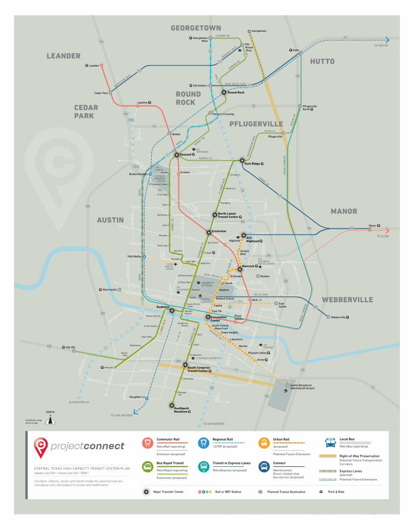
High Capacity Transit: Project Connect
The Capital Area Metropolitan Planning Organization (CAMPO) 2035 Plan calls for high-capacity transit as an important part of the solution for improving mobility in Central Texas. In 2011, CAMPO formed a Transit Working Group (TWG) of regional elected and civic leaders to create a cohesive transit plan for our region with support from the City of Austin, Capital Metropolitan Transportation Authority (Capital Metro), Lone Star Rail district and CAMPO.
After 18 months of study and public involvement, the TWG endorsed the “Project Connect High-Capacity Transit System Plan” linking 25 activity centers, 13 cities, and 4 counties with a mix of Express Bus on Express Lanes, Bus Rapid Transit, Urban Rail, Commuter Rail, and Regional Rail. The Austin City Council, Capital Metro and Lone Star Rail district’s Board of directors also endorsed the Project Connect High-Capacity Transit System Plan in resolutions on August 29, 2013, june 21, 2013 and October 4, 2013, respectively.
The TWG recognized that high-capacity transit is an important part of the solution for improving mobility in Central Texas and could also provide new travel options between Central Texas and the San Antonio metropolitan area.
The TWG determined that the Central Corridor is one of the highest priorities for regional high-capacity transit investment based on travel demand and high ridership potential, land use, economic development, employment, travel patterns and community input. A subsequent Central Corridor Advisory Group (CCAG) was formed of residents representing various constituencies to further evaluate and analyze the routes, alignments, modes, funding and organization and ensure a data-driven and open and transparent process with the community.
Central Corridor Urban Rail (recommended locally preferred alternative)
The Central Corridor Advisory Group (CCAG), chaired by Mayor Lee Leffingwell, met throughout the year evaluating the most viable high-capacity transit alignment, mode, and service characteristics within the Central Corridor.
The Project Connect team identified and prioritized multiple sub-corridors appropriate for high-capacity transit investment, using the TWG priorities and an extensive data-driven process with equally extensive community involvement. The team ultimately recommended for further study the Core, East Riverside and Highland Sub-Corridors, as the next high-capacity transit investment area of the Project Connect High-Capacity System Plan. The recommendation was subsequently endorsed by the CCAG, Austin City Council, Capital Metro and Lone Star Rail district’s Board of directors in resolutions on december 6, 2013, december 12, 2013, january 29, 2014 and February 6, 2014, respectively.
After further refinement from the project team on specific alignment, mode and service characteristics, CCAG endorsed the Project Connect team’s recommendation on june 13, 2014 for a Locally Preferred Alternative (LPA). The LPA consists of Urban Rail on a route from the East Riverside Corridor through the downtown, Capitol Complex, Medical School Complex, the University of Texas to Hancock and Highland. The alignment and mode chosen maximize the service characteristics: stop spacing, speed, frequency, and reliability prioritized via public feedback. This investment is projected to take about 10,000 cars off the roadway every weekday.
16Austin Transportation Department | austintexas.gov/transportation
N L
AMAR
BLV
D
DES
SAU
RD
HEA
THER
WIL
DE
BLV
D
GUAD
ALU
PE S
T
RED
RIV
ER S
T
S C
ONGR
ESS
AVE
S 1
ST S
T
S L
AMAR
BLV
D
MET
RIC
BLV
D
S L
AM
AR
BLVD
S 1
ST S
T
MA
NCH
ACA
RD
WES
TGAT
E B
LVD
ESCA
RPM
ENT
BLV
D
PLEA
SAN
T V
ALL
EY R
D
CHIC
ON
ST
SPR
ING
DA
LER
D
MO
NTO
POLI
S D
R
MO
NTO
POLI
S D
R
PAR
KER
LN
VAR
GA
S R
D
DU
VAL
ST
CAM
ERO
N R
D
MA
NO
R R
D
MOK
AN C
ORRI
DOR
JOH
NN
Y MO
RR
IS RD
AIR
POR
T BLVD
HOWARD LN
BURNET RD
MOPAC
UNIVERSITY BLV
D
BOWMAN RD
WHITESTONE BLV
D
WALSH TARLTON LN
35
35
35
35
71
1
360
360
1
1
71
45
45
130
734
969
130
130
290
183
183
183A
183A
183
183
183
183
ANDERSONLN
OHLENRD
BRAKER LN
PARMER LN
RESEARCHBLVD
GREAT HILLS TR
AIRPORT BLVD
PARMER LN
RIVERSIDE DR
BEN WHITE BLVD
STASSNEY LN
WILLIAM CANNON DR
OLTORF ST
ENFIELD RD
LAKE AUSTIN BLVD
BEE CAVES RD
35TH ST
W 5TH / 6TH
CONVICT HILL RD
DEAN KEETON ST
E 7TH
E 2ND
KOENIG LN
NORTHLAND DR
MANOR RD
HANCOCK DR
BEN WHITE BLVD
STASSNEY LN
WILLIAM CANNON DR
45TH ST
BU
RN
ET
RD
MO
PAC
MO
PAC
WO
OD
RO
W A
VE
BU
LLCR
EEK
RD
EXP
OS
ITIO
N B
LVD
BA
LCO
NES
DR
290
290
290
79
79
RUNDBERG LN
BER
KM
AN
DR
SP
RIN
GD
ALE
RD
CAM
ERO
N R
D
STECK AVE
AIRPORT BLVD
LOYOLA LN
LOO
P 360
ROGGE LN
ST JOHNS AVE
RUTHERFORD RD
BLU
FFS
PR
ING
S R
D
JOLL
YVIL
LER
D
PO
ND
SP
RIN
GS
RD
1431
1431
1460
LEANDER RD
MAYS ST
PALM VALLEY BLVD
PECAN ST
MLK JR, BLVD
E 12TH
GOVALLE AVE
MO
KA
N C
OR
RID
OR
UNIVERSITYOF TEXAS
ACCRIVERSIDE
ACCNORTHRIDGE
CAPITOLCOMPLEX
ST EDWARD’S UNIVERSITY
ACCRIO GRANDE
SETONMEDICALCENTER
THEDOMAIN
UT PICKLERESEARCH
CENTER
DELLCHILDREN’SMEDICAL CENTER
Oltorf
SoCoTravis Heights
Lakeshore
Burton
Pleasant Valley
Grove
South Central Waterfront
Oltorf West
Bluebonnet
BrodieOaks
Westgate
Lamar Square
RepublicSquare
Austin HistoryCenter
Capitol
Museum
UT/West Mall
UT/Dean Keeton
Hyde Park
North Loop
Allandale
West 38th
Justin
Northcross
Ohlen
Crossroads
UT Research Center
Domain
35th/MoPac
Braker/Domain
Brentwood
North LamarTransit Center
Rundberg
Masterson
Tech Ridge
Manor
Webberville
TriangleSunshine
Rosedale
Barton Springs
AuditoriumShores
St Edward’s
South CongressTransit Center
Little Texas
PleasantHill
Medical School
Stadium
UT North
St David’s Mueller
EastAustin
AirportBlvd
ACCHighland
Capitol
East 7th
Slaughter Ln
TO SAN ANTONIO
SLAUGHTER LN
TO SAN MARCOS
MLK, Jr
PlazaSaltillo
Highland
Georgetown
Hutto
PflugervilleNorth
GeorgetownWest
Lakeline
Leander
Cedar Park
Kramer
Crestview
Hancock
Seaholm
ConventionCenter
Round Rock
McNeil
Hester’s Crossing
Pflugerville
Old Settlers
TSU Round Rock
Howard
Oak Hill
West Austin
Austin-BergstromInternational Airport
Chinatown
SouthparkMeadows
TO ELGIN
TO TAYLOR
GEORGETOWN
ROUND ROCK
LEANDERHUTTO
MANOR
WEBBERVILLE
CEDARPARK
AUSTIN
PFLUGERVILLE
schematic mapnot to scale
Regional Rail
LSTAR (proposed)
Urban Rail
(proposed)
Potential Future Extensions
Transit in Express Lanes
MetroExpress (proposed)
Connect
MetroConnectDirect, limited-stopbus service (proposed)
Local Bus
MetroBus (operating)
Bus Rapid Transit
MetroRapid (operating)
Extensions (proposed)
Express Lanes(planned)
Potential Future Extensions
Potential Future TransportationCorridors
Right-of-Way Preservation
Major Transfer Center Planned Transit Destination Park & RideRail or BRT Station
CENTRAL TEXAS HIGH-CAPACITY TRANSIT SYSTEM PLANadopted June 2012 / revised June 2014 / DRAFT
Corridors, stations, routes and transit modes for planned lines areconceptual only, and subject to review and modification.
Commuter Rail
MetroRail (operating)
Extension (proposed)

17Austin Transportation department | austintexas.gov/transportation
Town
Lake
Lady
Bird
Lake
Colorado
River
801
801
803
803
N LAM
AR B
LVD
GUADAL
UPE S
T
S 1S
T S
T
S C
ONGR
ESS
AVE
S C
ONGRESS A
VE
E OLTORF ST
W OLTORF ST
BARTON SPRIN GS RD
E MARTIN LUTHER KING BLVD
W MARTIN LUTHER KING BL
BURN
ET R
D
W 45TH ST
E 51ST ST
W 51S T ST
AIRPORT BLVD
AIRPORT BLVD
AIRPORT BLVD
E 1ST ST
E 1ST ST
W CESAR CHAVEZ ST
E 12TH ST
MANCHAC
A RD
CAMERON RD
SPRIN
GDALE R
D
E 7TH ST
E 7TH ST
PLEASANT VALL EY RD
PLEA
SANT
VAL
LEY
RD
GROV
E B
LVD
MONTO
POLI
S D
R
LAKESHORE BLVD
MANOR RDDEAN KEETON ST
W KOENIG LN
E 38 1/2 ST
S LAMAR BLVD
N LAM
AR B
LVD
E RIVERSIDE DR
35
35
35
RED RIV
ER S
T
SAN
JAC
INTO
BLV
D
E RIVERSIDE DR
TRIN
ITY
ST
TRIN
ITY
ST
AIRP
ORT
BLV
DM
IDDL
EFI
SKVI
LLE
RD
71
1
183
290
290
MOPAC W
1ST ST
W 38TH ST41ST ST
AIRP
ORT
BLV
D
UNIVERSITYOF TEXAS
DOWNTOWN AUSTIN
HANCOCK
HIGHLAND
TRAVISHEIGHTS
MONTOPOLIS
ACC RIVERSIDE
Lakeshore
Burton
Pleasant Valley
Grove
Travis Heights
Stadium
Airport Blvd
ACC Highland
St David’s
UT North
South CentralWaterfront
ConventionCenter
East 7th
Capitol
MedicalSchool
Seaholm
Museum
UT/WestMall
UT/Dean Keeton
Capitol
WooldridgeSquare
RepublicSquare
SoCo
Oltorf
St Edward’s
South CongressTransit Center
AuditoriumShores
Barton Springs
Lamar Square
Oltorf West
Bluebonnet
BrodieOaks
PlazaSaltillo
MLK, Jr
Highland
Crestview
HydeParkWest
38th
Rosedale
Sunshine
North Loop
Allandale
Brentwood
Triangle
Mueller
East Austin
toAustin-BergstromInternationalAirport
to 35th/MoPac
to West Austin
Hancock
to Southpark Meadows
to 35th/MoPac
Proposed First Lineof Urban Rail
Proposed Station
Transfer Point
MetroRapid 801 isoperating presently
MetroRapid 803 iscoming Fall 2014
EXISTING HIGH-CAPACITY TRANSIT
CENTRAL CORRIDOR
MetroRail
PotentialFuture Extension
MetroRapid
Park & Ride
Planned TransitDestination
Subject to ChangeJUNE 2014
PROPOSED HIGH-CAPACITY TRANSIT
0 0.500.25 1.00mi
SCALE IN MILES

18Austin Transportation Department | austintexas.gov/transportation
The LPA meets the purpose and needs by providing a reliable alternative to congestion, reinforcing the success of the core through improved access and affordable mobility, and providing connectivity to the city’s and region’s activity centers. Additionally, the Urban Rail project provides a program compatible with urban physical constraints, with the bike and pedestrian components of the bridge to be built in accordance with the Council approved Waller Creek design, serving current demands and shaping future growth, implementing an integrated high-capacity transit system, and being competitive for Federal Transit Administration (FTA) funding.
The Project Connect Central Corridor staff recommended Central Corridor LPA includes:
• 9.5 mile Urban Rail double-tracked, electrified route in mostly dedicated guideways, with 10-15 minute frequency, stops one half to 1 mile apart, and with an average speed of 20-30 mph. The route runs along the following corridor:
• Riverside corridor, Grove to South Shore
• Ladybird Lake crossing at Trinity
• Trinity Corridor, serving Convention Center, downtown and dell Medical School
• San jacinto, serving University of Texas
• Red River serving St. david’s Hospital and Hancock Center
• Airport Boulevard to Highland ACC Campus
• Estimated 2030 daily ridership: 16,000-20,000 passengers per day
• 10,000 new transit riders to system
• Travel times: Grove to Convention Center = 11 minutes and ACC Highland to Convention Center = 17 minutes
Funding
Capital – Costs to construct the LPA are estimated to total $1.38 billion (2020 dollars). The city is planning on about one half (1/2) of that to be funded via grants from the Federal Transit Administration (FTA) and/or other granting agencies. Therefore, about $700 million of the total capital funding would need to be funded from local, non-federal sources.
Phasing - The LPA contemplates a 9.5 mile urban rail system running from Riverside and Grove to the Highland/ACC campus. The costs include almost $200 million for the Hancock to Highland portion of the route with almost $100 million of those funds allocated for the interface (tunnel under existing rail line) with Capital Metro’s Redline at the Hancock area. With design only at about 2-3% completion, this cost has been consciously set at a high level. With further refinement, these costs could come down. However, it is unknown at this time where the costs will ultimately land. With that in mind, the $700 million estimate could be reduced in this next funding request. For example, a $600 million request could be offered as long as it is clearly communicated that the LPA may have to be terminated at Hancock if the costs to construct all the way to the Highland/ACC campus don’t drop substantially. In other words, the concept can remain to build from Grove to Highland with the understanding that Highland may not be achievable, but the intent will remain to perform the design and environmental clearance on the total 9.5 mile route.
Operation and Maintenance – Annual costs to operate the LPA in 2022 are estimated to total about $22 million. Funding sources will be Capital Metro sales tax, FTA operating assistance (5307 funding), operations savings, fare revenue, the remaining/unallocated quarter (1/4) cent funds, parking revenue, potential Public Improvement districts, etc.

19Austin Transportation department | austintexas.gov/transportation
Governance
The City of Austin and Capital Metro will build on the existing Project Connect partnership with Austin as the “owner/constructor” and Capital Metro as the “operator.” The existing Executive Level “joint Executive Team” framework will continue with an Urban Rail Project director appointed to manage the day to day activities, including developing the New Starts grant submittal to the Federal Transit Administration. Both sovereign boards (the Austin City Council and the Capital Metro Board of directors) would maintain their authority, with an Advisory Board consisting of Council members and Capital Metro Board members adding policy level guidance. An amended Interlocal Agreement (ILA), building on the existing agreement, will detail this partnership. The amendments to the ILA will be developed after November (due to workload considerations) and would be brought forward for consideration upon completion.
OwNER OPERatOR
POliCy lEvEljoint City-Capital Metro Policy Advisory Board
Members Appointed by Each Agency
ExECUtivE lEvEljoint Executive Team (jET) Framework Continues
PROjECt lEvElUrban Rail Project director
City Manager President/CEO

20Austin Transportation Department | austintexas.gov/transportation
SUMMARY OF 2014 AUSTIN STRATEGIC MOBILITY PLAN ANd PROPOSEd FUNdING
PROjECtS OF REgiONal SigNiFiCaNCE
PROPOSEDFUNDiNg
NOtES/ExPECtED PROjECtStaRt/DElivERy
I-35 downtown access roadway, Riverside Interchange
$ 120M
$ 90M
Seek alternativefunding
*No funding identified. City will advocate for alternative funding with regional partners. Project date: 2018
Preliminary coordination underway. Project date: 2016
Facilitates potential rail extension to ABIA. Project date: 2019
Facilitates potential rail extension to ABIA. Project date: 2019
*Seek cost efficiencies/alternative funding for $100M . If alternative funding or cost reductions are not achieved, build as far north of Hancock as possible. Engineering ongoing. Project date: 2019
Preliminary coordination underway for Loop 360; RR 620; RM 2222 and FM 734. Project date varies: 2015-2019
Includes construction for Rail crossing. Project date: 2017
Project date varies 2015 (William Cannon to Stassney) - 2016 (Oltorf)
$ 30M
$ 81.5M
$ 34M
$ 44.5M
$ 600M
$1.0B
South I-35 Interchanges (Oltorf, Stassney, William Cannon)
I-35 North/US 183 Interchange
SH 71/ABIA direct Access and Rail extension feasibility analysis
US 183/Riverside Interchange
Regional Safety and Mobility Corridor development Programs (SL 360, RM 620, RM 2222, FM 734, Lamar, RM 1826, Seaholm, ABIA, South/Southwest, Mueller
2014 Proposed Strategic Mobility Plan Total
Urban Rail LPA E. Riverside to Highland ACC
I-35 Regional TMC/ATMS

21Austin Transportation Department | austintexas.gov/transportation
austin Strategic Mobility Plan 2014 – Funding Plan
Capital Funding - Financial staff evaluated the tax impact for various bond programs as part of the Bond Capacity Analysis in April 2014. They developed the tax rate increases projected over 5 years to fund programs up to a $96 5 million – 6 cent increase. Since the $1 billion program, shown above, exceeds the 6-cent tax rate increase scenario that staff presented, financial staff’s subsequent analysis has determined that a tax rate increase of 6.25 cents would be required to issue $1 billion in new bonds. As assumed with the other bond capacity scenarios, this 6.25 cent increase assumes an increase in assessed valuation. At 6.25 cents/ $1 billion in new debt – the city would still be in compliance with its debt related financial policies. The tax rate increases required for alternative programs are shown below.
Operational and Maintenance Funding – As stated above, the annual costs to operate the Urban Rail system in 2022 are estimated to total about $22 million. Funding sources will be Capital Metro sales tax, FTA operating assistance (5307 funding), operations savings, fare revenue, the remaining/unallocated one quarter (1/4) cent funds, parking revenue, potential Public Improvement districts, etc.
Funding for the operations and maintenance of the roadway projects will primarily be the responsibility of TxdOT since a majority of the projects in the Mobility Plan are on the State system.
tax RatE iNCREaSE OvER 5 yEaRS
NEw DEbt CaPaCity
1-cent
2-cents
3-cents
4-cents
5-cents
6-cents
6.25 - cents
$115 million
$265 million
$440 million
$615 million
$790 million
$965 million
$1.0 billion

22Austin Transportation Department | austintexas.gov/transportation

23Austin Transportation department | austintexas.gov/transportation
Austin Transportation Department512.974.1150 | austintexas.gov