Embed Size (px)
Citation preview
2013
Annual Report of the Status of Condition A: Wetland Mitigation
SAN ONOFRE NUCLEAR GENERATING STATION (SONGS) MITIGATION PROGRAM
2
2013
Annual Report of the Status of Condition A: Wetland Mitigation
SAN ONOFRE NUCLEAR GENERATING STATION (SONGS) MITIGATION PROGRAM
Submitted to the California Coastal Commission July 2014
By Mark Page, Stephen Schroeter and Daniel Reed Marine Science Institute, University of California Santa Barbara
Contributors David Huang, Andres Deza, Katalin Patonai, Emily Blair, Justin Hoesterey, Russell
Johnston, Marine Science Institute, University of California Santa Barbara
Science Advisory Panel Richard Ambrose, University of California Los Angeles
Peter Raimondi, University of California Santa Cruz Russell Schmitt, University of California Santa Barbara
Coastal Commission Staff Kate Huckelbridge
John Dixon Gabriel Buhr
3
Table of Contents
1. Executive Summary 4
2. Introduction 6
2.1. Purpose of Report 6
2.2. Background 6
3. Project Description 9
3.1. Wetland Restoration Design and Construction Timetable 10
3.2. Status Update of the San Dieguito Wetlands Restoration Project 13
3.3. On-going Management Tasks 17
3.4. Summary of Key Findings for 2013 17
4. Methods of Project Evaluation 19
4.1. Monitoring Plan 19
4.2. Performance Standards 19
4.3. Reference Wetlands 20
4.4. Determination of Similarity 20
5. Progress Report on the San Dieguito Wetlands Restoration Project 22
5.1. Absolute Performance Standards 22
5.2. Relative Performance Standards 29
5.3. Summary of Assessment of Absolute and Relative Standards 43
6. References 45
4
1.0 Executive Summary Condition A of the San Onofre Nuclear Generating Station’s (SONGS) coastal development permit requires Southern California Edison (SCE) and its partners to construct or substantially restore a minimum of 150 acres of tidal wetlands, excluding buffer zone and transition, as partial mitigation for the projected reductions in populations of adult fish throughout the Southern California Bight due to operations of the plant. San Dieguito Lagoon, located in northern San Diego County was chosen as the wetland mitigation site. Construction of the San Dieguito Wetlands Restoration Project began September 2006 and was completed in September 2011. The success of the San Dieguito Wetlands Restoration Project in satisfying the mitigation requirements is based on its ability to meet physical and biological performance standards provided in the SONGS coastal development permit. Annual monitoring is required to determine whether the restoration project has met these standards. Monitoring also tracks ecosystem development and identifies opportunities for adaptive management. The monitoring is overseen by the California Coastal Commission (CCC) and is done independently of SCE. This report summarizes the second year of post-construction monitoring done in 2013. During 2013, the development of vegetation continued to be promising in some areas, particularly along the border of the basin (module W1) west of the I-5 freeway, and cordgrass is becoming well-established in some areas of module W4, east of the I-5 freeway. In other areas, however, development of vegetation remained sparse, particularly in modules W2/3, located adjacent to the San Dieguito River west of the I-5 freeway. Vegetation has been slow to establish in these modules through natural recruitment except at the lowest tidal elevations or in depressions, and extensive plantings of pickleweed and other species at higher tidal elevations in 2009 were unsuccessful. Modules W2/3 were graded by design to a high elevation to achieve high salt marsh habitat. However, these high areas are hit by the tides infrequently, and with little change in elevation over distances exceeding 100m, tidal waters sit on the surface where evaporation contributes to high soil salinities that are probably detrimental to plant establishment. Tidal creek extensions were constructed in November 2010 to better convey tidal waters from the river channel to these high marsh plain areas. Pickleweed colonized along the edges of the creeks, but little development of vegetation occurred on the high marsh plain. SCE re-graded these modules in March 2014 to improve inundation and drainage with the goal of improving plant establishment.
The restored wetland is continuing to support birds, fish, invertebrates, and eel grass and did so even during construction. During monitoring surveys in 2013, 92 species of birds were recorded. The five most abundant species were Western Sandpiper, American Wigeon, Dowitcher, Green-winged Teal, and Least Sandpiper. During monitoring surveys in 2013, 23 species of fish were recorded. The five most abundant taxa included juvenile goby (<20 mm in length), Arrow Goby, Killifish, juvenile Silversides (<30 mm in length, includes Topsmelt, Jacksmelt, and Grunion), Topsmelt, and Yellowfin Goby. Examples of other sampled taxa included Killifish, Pipefish, Staghorn Sculpin, Mudsucker, and Diamond Turbot. Three species of rays (Bat Rays, Round Stingrays, and Butterfly Rays) were also recorded. Fifty-two taxa of macro-invertebrates were recorded. Four of the five most abundant taxa were small worms. Larger sampled taxa included several species of clams, snails, and crustaceans.
5
The success of the San Dieguito Wetlands in meeting the mitigation requirement for a given year will be based on its ability to meet physical and biological performance standards provided in the SONGS permit. A summary report is provided on the results of the second year of monitoring of the San Dieguito Wetlands Restoration Project, including an evaluation of the progress of the restoration project towards meeting the performance standards required for successful mitigation. The San Dieguito Wetlands Restoration Project satisfied four of five of the absolute standards. Standards satisfied included those pertaining to topography, tidal prism, plant reproductive success, and exotic species. The absolute standard not yet met pertains to Habitat Areas. The restored wetland also showed encouraging results in being similar to the reference wetlands for 11 of 15 (0.73) of the relative standards. This proportion was higher than the lowest performing reference wetland. Four of relative standards were not similar to the reference wetlands. These standards pertain to vegetation cover, macro-invertebrate density in Main Channel and Tidal Creek Habitats, and macro-invertebrate species richness in Tidal Creek Habitat. Spartina canopy architecture, which was not similar to Tijuana Estuary in 2012, was similar to this reference wetland in 2013. It is very promising that Spartina is becoming established, spreading, and increasing in plant height throughout portions of the San Dieguito Wetlands Restoration. The poor plant development in modules W2/3 was largely responsible for the less encouraging results for vegetation cover in the restored site in 2013. The reason for the less encouraging results for macro-invertebrates is unknown at present, but may be related to differences in soil properties (e.g., organic matter content, grain size) between the restored wetland and reference wetlands or a requirement for more time for the invertebrates to become established.
6
2.0 Introduction
2.1 Purpose of Report This report focuses on Condition A of the San Onofre Nuclear Generating Station’s (SONGS) coastal development permit (6-81-330-A), which pertains to mitigation for SONGS impacts to fish populations in the Southern California Bight. Southern California Edison (SCE) and the California Coastal Commission (CCC) have clear and distinct roles in the implementation of Condition A. Under the condition, SCE is required to construct or substantially restore a minimum of 150 acres of tidal wetlands, excluding buffer zone and transition habitat. The CCC is to provide scientific oversight and monitoring of the wetland mitigation project that is independent of SCE. This report presents the results from the CCC’s monitoring of the progress of the SONGS wetland mitigation project (hereafter referred to as the San Dieguito Wetlands) during 2013 (the second year following completion of construction of the wetland) and summarizes the status of the project’s progress towards compliance with Condition A of the SONGS permit.
2.2 Background SONGS Operations: In 1974, the California Coastal Zone Conservation Commission issued a permit (No. 6-81-330-A, formerly 183-73) to SCE for Units 2 and 3 of the San Onofre Nuclear Generating Station (SONGS). SONGS is located on the coast in north San Diego County. Construction of SONGS Units 2 and 3 was completed in 1981. Operation of Units 2 and 3 began in 1983 and 1984, respectively. The SONGS Unit 2 and 3 reactors are cooled by a single pass seawater system and have separate intake lines, each 18 feet in diameter that are located in about 30 feet of water offshore of the power plant. The volume of water taken in each day by these two intake lines when Units 2 and 3 are fully operational is about 2.4 billion gallons. The water taken in is heated to approximately 19°F above ambient in the plant and then discharged through an extensive diffuser system designed to dissipate the heat. Power plant heated cooling water kills fish eggs, larvae and small immature fish taken into the plant. The discharge pipe for Unit 2 terminates 8,500 feet offshore, while the discharge pipe for Unit 3 terminates 6,150 feet offshore. The last 2,500 feet of the discharge pipes for Units 2 and 3 consist of a multi-port diffuser that rapidly mixes the cooling water with the surrounding water. To cool the discharge water, the diffusers draw in ambient seawater at a rate about ten times the discharge flow and mix it with the discharge water. The surrounding water is swept up along with sediments and organisms and transported offshore at various distances. Mixing caused by the diffuser system results in the formation of a turbid plume in the vicinity of the San Onofre kelp forest, which is located adjacent to the two diffuser lines. Neither of Units 2 and 3 of SONGS are currently producing power. Unit 2 was shut down in early January 2012 for routine refueling and replacement of the reactor vessel head.
On
January 31, 2012, Unit 3 suffered a small radioactive leak largely inside the containment shell, with a very small release to the environment below allowable limits, and the reactor was shut down per standard procedure.
On investigation, both units were found to show
premature wear on over 3,000 tubes, in 15,000 places, in the replacement steam generators installed in 2010 and 2011. A decision to shutdown was made on June 7, 2013 and a certification of permanent cessation of power operations was issued on July 22, 2013.
7
The operating license was modified to “possession” only and SCE is now longer authorized to operate the reactors or place fuel in the reactors. Since the shutdown, the flow in each unit has been reduced to about 49 million gallons per day or roughly 4% of the normal operating flow.
SONGS Impacts: A condition of the SONGS permit required study of the impacts of the operation of Units 2 and 3 on the marine environment offshore from San Onofre and mitigation of any adverse impacts. The impact assessment studies found that the SONGS cooling water system for Units 2 and 3 had major adverse impacts to living marine resources, which included: • Projected reductions in populations of adult fish throughout the Southern California Bight
based on losses of fish eggs, larvae, and immature fish entrained by the cooling water intakes and killed inside the power plant.
• Measured reductions in local populations of adult fished caused by the mortality of fish impinged against the cooling water screens inside the power plant.
• A substantial reduction in the size of the giant kelp forest and its associated community adjacent to the SONGS diffusers.
Mitigation Requirements: As a result of the impact studies, the CCC added new conditions in 1991 to mitigate the adverse impacts of the power plant on the marine environment that require SCE and its partners to: (1) create or substantially restore at least 150 acres of southern California wetlands as out-of-kind mitigation for the losses of immature fish (Condition A), (2) install fish barrier devices at the power plant to reduce the losses of adult fish killed in the plant (Condition B), and (3) construct a 300-acre kelp reef as in-kind mitigation for the loss of giant kelp forest habitat (Conditions C). The 1991 conditions also required SCE to provide the funds necessary for CCC to contract marine scientists to perform technical oversight and independent monitoring of the mitigation projects (Condition D). In 1993, the CCC added a requirement for SCE to partially fund construction of an experimental white sea bass hatchery. Due to the experimental nature of the hatchery, the CCC did not assign mitigation credit to its operation.
In April 1997, the Commission revised Condition A to allow the permittee to meet its 150-acre wetland acreage requirement by receiving up to 35 acres enhancement credit for the permittee’s permanent, continuous tidal maintenance at San Dieguito Lagoon.
The CCC also confirmed in April 1997 its previous finding that independent monitoring and technical oversight was required in Condition D to ensure full mitigation under the permit. Condition D requires SCE and its partners to fund scientific and support staff retained by the CCC to oversee the site assessments, project design and implementation, and monitoring activities for the mitigation projects. Scientific expertise is provided to the CCC by a small technical oversight team hired under contract. The technical oversight team members include three Research Biologists from UC Santa Barbara: Steve Schroeter, Ph.D., marine ecologist, Mark Page, Ph.D., wetlands ecologist (half time), and Dan Reed, Ph.D., kelp forest ecologist (half-time). In addition, a science advisory panel advises the CCC on the design, implementation, monitoring, and remediation of the mitigation projects. Current science advisory panel members include Richard Ambrose, Ph.D., Professor, UCLA, Peter Raimondi, Ph.D., Professor, UC Santa Cruz, and Russell Schmitt, Ph.D., Professor, UC
8
Santa Barbara. In addition to the science advisors, the contract program staff is aided by a team of field assistants hired under a contract with the University of California, Santa Barbara to collect and assemble the monitoring data. The contract program staff is also assisted on occasion by independent consultants and contractors when expertise for specific tasks is needed. The CCC’s permanent staff also spends a portion of their time on this program, but their costs are paid by the CCC and are not included in the SONGS budget.
9
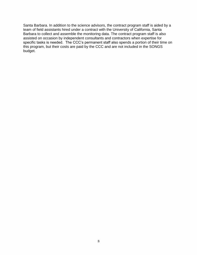
3.0 Project Description The CCC decided that the goal of out-of-kind compensation for adverse effects on fish populations in the Southern California Bight due to SONGS operations will most likely be met if the wetland mitigation project: (1) is located near SONGS, but outside its influence to ensure that the compensation for lost resources will occur locally rather than at a distant location far from the impacts (Fig. 3.0.1), (2) creates or substantially restores 150 acres of wetlands, and (3) performs for a period of time equal to the operating life of SONGS Units 2 & 3.
Figure 3.0.1. Locations of SONGS, the impact site, San Dieguito Lagoon, site of the San Dieguito Wetlands Restoration Project, and three wetlands that are used as reference sites to evaluate the performance of the restoration project: Carpinteria Salt Marsh, Mugu Lagoon, and Tijuana Estuary.
10
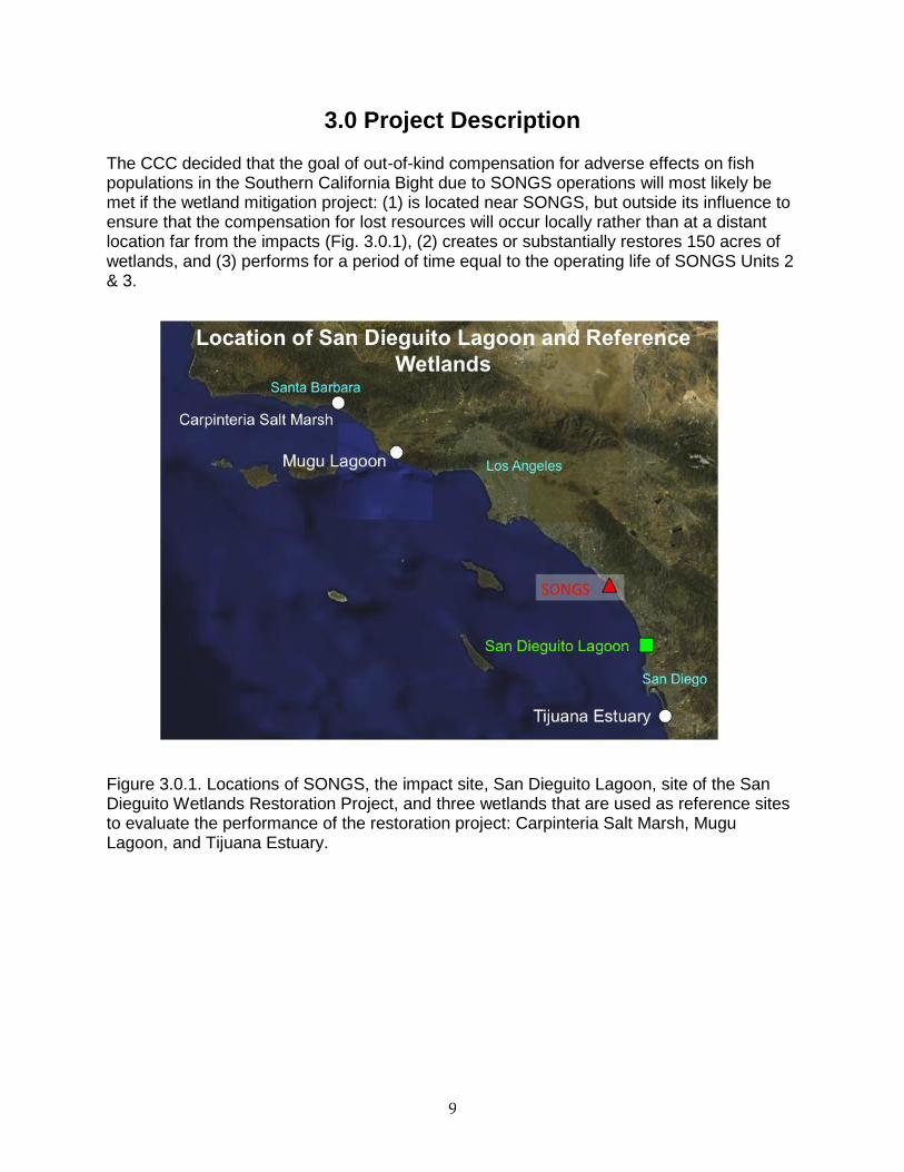
3.1 Wetland Restoration Design and Construction Timetable The restoration project included excavation and grading to create intertidal salt marsh, mudflat, and subtidal basin habitats (Fig. 3.1.1). In addition, four nesting sites were constructed, which were not part of the SONGS mitigation requirement. Disposal sites received most of the over 2 million cubic yards of material excavated during construction of the wetland. Construction began in September of 2006 with most excavation and grading completed by the end of 2008 (Fig. 3.1.2, 3.1.3ab). Construction of the large subtidal and intertidal basin (44 acres) in Area 2A west of Interstate 5 commenced in December 2006 and was completed with the opening to tidal exchange in January 2008. Construction of wetland habitat commenced in other areas within the restoration site in April 2007. This included modules on the east side of Interstate 5, both north (Area 3) and south (Area 2B) of the San Dieguito River that were graded to create high and middle salt marsh and intertidal mud flat habitat. Excavation and grading, including the construction of tidal creek networks, was completed in Area 3 and these areas were opened to tidal exchange in December 2008. Excavation and grading of Area 2B was also completed in December 2008. Initial grading of
Figure 3.1.1. The design plan view of the restoration project that was approved by the CCC. The project included the creation of tidal salt marsh, indicated by shades of green, mudflat, indicated by the light brown, and subtidal basin, indicated by blue. In addition, four nesting sites, shown in gray, were constructed, which were not part of the SONGS mitigation requirement. The areas in pink are disposal sites. Dark gray linear features are berms along the effective flow area of the San Dieguito River. The yellow boxes that indicate Areas 1, 2a, 2b, and 3 pertain to the staging of construction activities.
San Dieguito Wetlands Restoration Design
Source: Final Restoration Plan for San Dieguito Wetlands
salt marsh
mud flat
subtidal basin
nesting sites
nesting site
disposal site
Grand Ave.
11
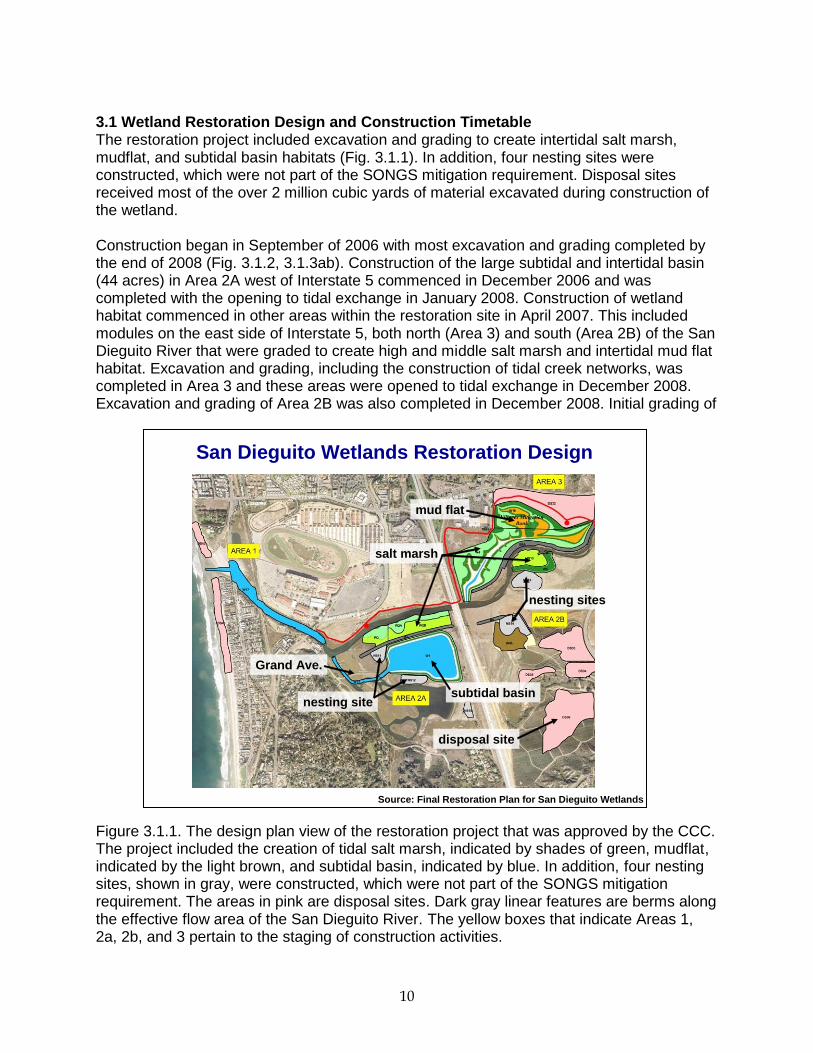
Modules W2/3 (Fig. 3.1.2) in Area 2A were completed in February 2008 with tidal creek extensions added to linear channels that were originally constructed in November 2010. This area was re-graded again in March 2014 to lower the elevation of the marsh plain and improve drainage to facilitate the development of marsh vegetation. The construction of additional wetland (“Grand Avenue”) was completed in February 2011. Following excavation and grading, portions of the restoration project were planted with salt marsh vegetation. Planting of selected species (largely pickleweed) in high marsh habitat occurred in January/February 2009. Test planting of cordgrass in the low marsh occurred in 2009. Planting throughout the restoration was done following final inlet channel dredging, which was completed in September 2011. Material excavated from the construction site was deposited in upland disposal sites within the project area. Berms designed to constrain storm runoff were completed in February 2009 along the boundary of the effective flow area of the San Dieguito River (Fig. 3.1.1).
Figure 3.1.2. Construction timeline for the San Dieguito Wetlands Restoration Project.
12
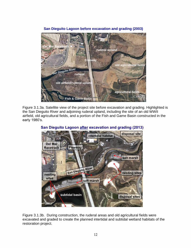
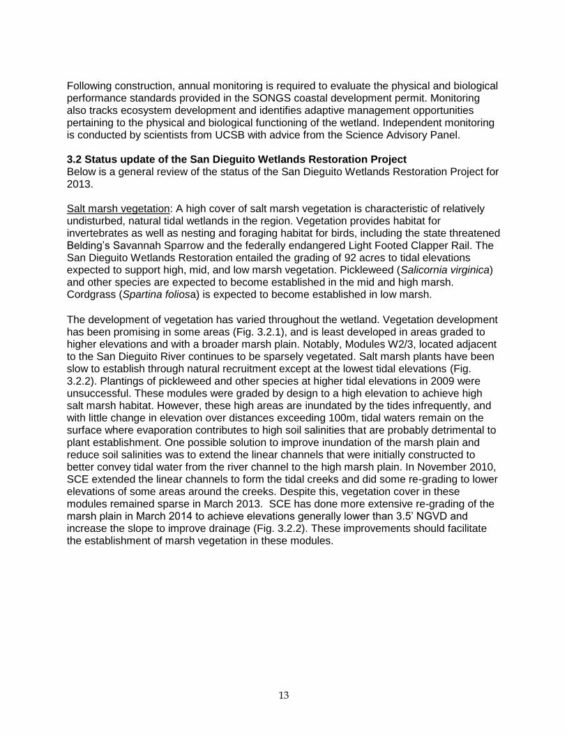
Figure 3.1.3a. Satellite view of the project site before excavation and grading. Highlighted is the San Dieguito River and adjoining ruderal upland, including the site of an old WWII airfield, old agricultural fields, and a portion of the Fish and Game Basin constructed in the early 1980’s. Figure 3.1.3b. During construction, the ruderal areas and old agricultural fields were excavated and graded to create the planned intertidal and subtidal wetland habitats of the restoration project.
old airfield/ruderal upland
old agricultural fields
ruderal upland
Del Mar Racetrack
San Dieguito River
Freeway
ruderal
San Dieguito Lagoon before excavation and grading (2003)
Fish & Game Basin
agricultural fields
13
Following construction, annual monitoring is required to evaluate the physical and biological performance standards provided in the SONGS coastal development permit. Monitoring also tracks ecosystem development and identifies adaptive management opportunities pertaining to the physical and biological functioning of the wetland. Independent monitoring is conducted by scientists from UCSB with advice from the Science Advisory Panel. 3.2 Status update of the San Dieguito Wetlands Restoration Project Below is a general review of the status of the San Dieguito Wetlands Restoration Project for 2013. Salt marsh vegetation: A high cover of salt marsh vegetation is characteristic of relatively undisturbed, natural tidal wetlands in the region. Vegetation provides habitat for invertebrates as well as nesting and foraging habitat for birds, including the state threatened Belding’s Savannah Sparrow and the federally endangered Light Footed Clapper Rail. The San Dieguito Wetlands Restoration entailed the grading of 92 acres to tidal elevations expected to support high, mid, and low marsh vegetation. Pickleweed (Salicornia virginica) and other species are expected to become established in the mid and high marsh. Cordgrass (Spartina foliosa) is expected to become established in low marsh.
The development of vegetation has varied throughout the wetland. Vegetation development has been promising in some areas (Fig. 3.2.1), and is least developed in areas graded to higher elevations and with a broader marsh plain. Notably, Modules W2/3, located adjacent to the San Dieguito River continues to be sparsely vegetated. Salt marsh plants have been slow to establish through natural recruitment except at the lowest tidal elevations (Fig. 3.2.2). Plantings of pickleweed and other species at higher tidal elevations in 2009 were unsuccessful. These modules were graded by design to a high elevation to achieve high salt marsh habitat. However, these high areas are inundated by the tides infrequently, and with little change in elevation over distances exceeding 100m, tidal waters remain on the surface where evaporation contributes to high soil salinities that are probably detrimental to plant establishment. One possible solution to improve inundation of the marsh plain and reduce soil salinities was to extend the linear channels that were initially constructed to better convey tidal water from the river channel to the high marsh plain. In November 2010, SCE extended the linear channels to form the tidal creeks and did some re-grading to lower elevations of some areas around the creeks. Despite this, vegetation cover in these modules remained sparse in March 2013. SCE has done more extensive re-grading of the marsh plain in March 2014 to achieve elevations generally lower than 3.5’ NGVD and increase the slope to improve drainage (Fig. 3.2.2). These improvements should facilitate the establishment of marsh vegetation in these modules.
14
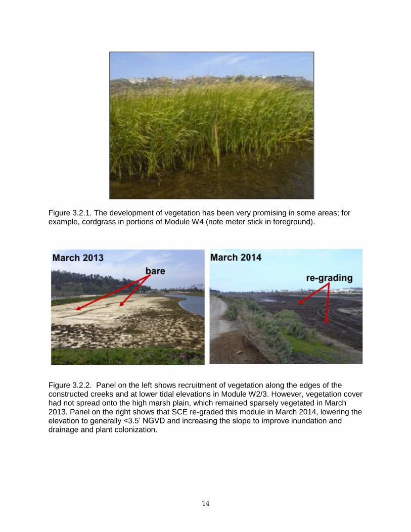
Figure 3.2.1. The development of vegetation has been very promising in some areas; for example, cordgrass in portions of Module W4 (note meter stick in foreground).
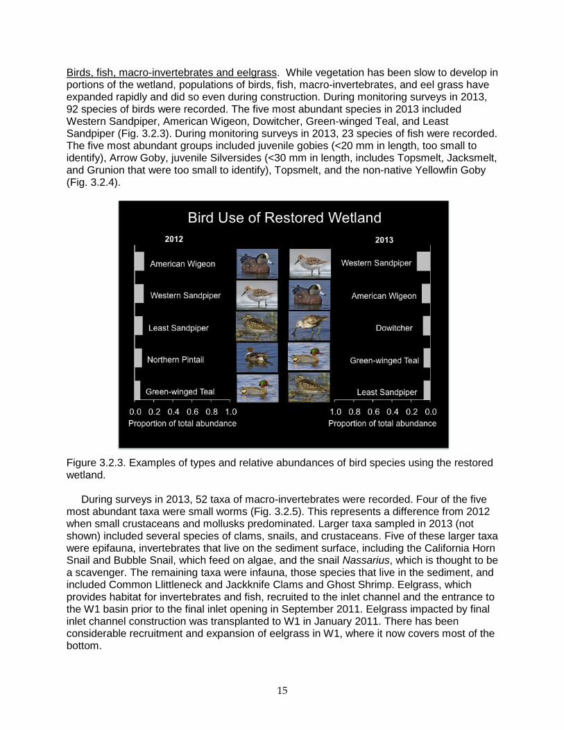
Figure 3.2.2. Panel on the left shows recruitment of vegetation along the edges of the constructed creeks and at lower tidal elevations in Module W2/3. However, vegetation cover had not spread onto the high marsh plain, which remained sparsely vegetated in March 2013. Panel on the right shows that SCE re-graded this module in March 2014, lowering the elevation to generally <3.5’ NGVD and increasing the slope to improve inundation and drainage and plant colonization.
15
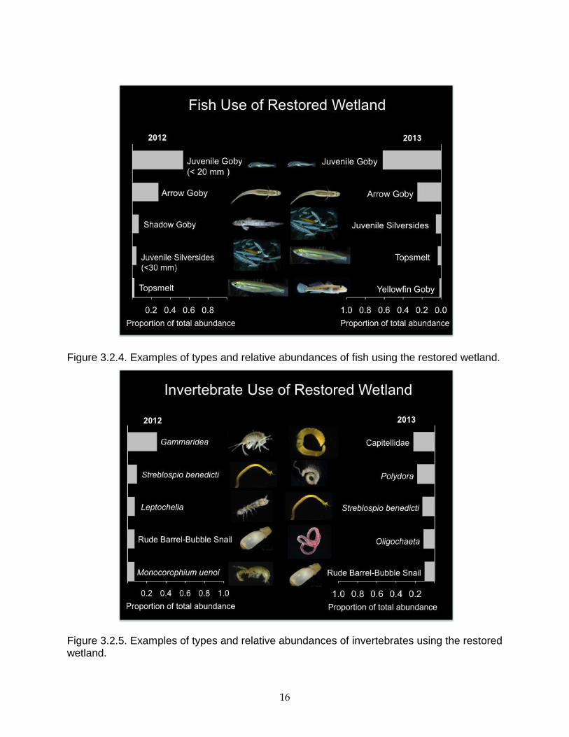
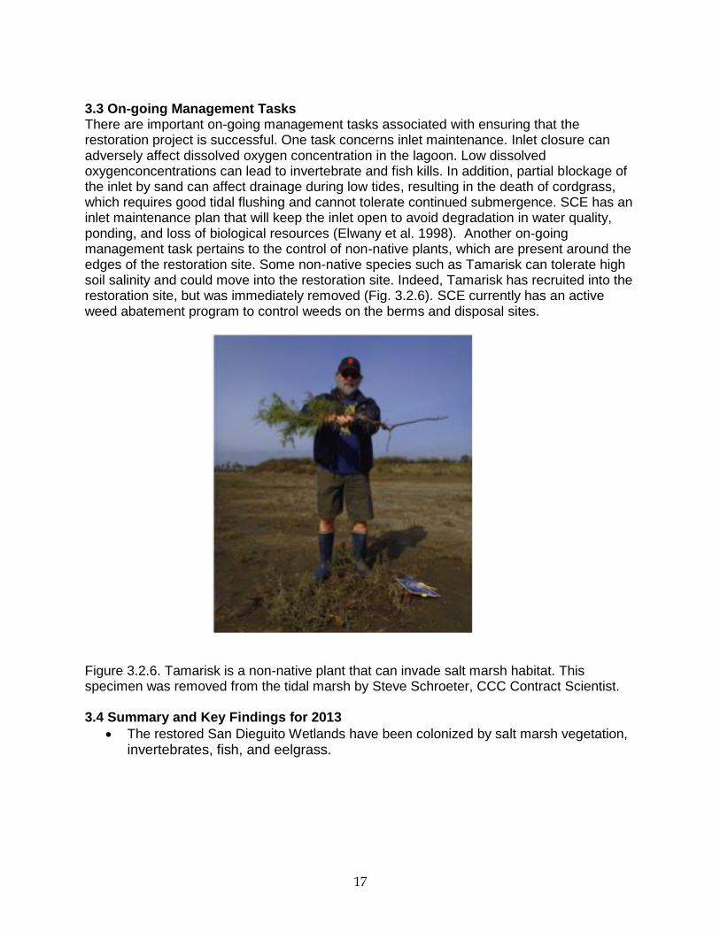
Birds, fish, macro-invertebrates and eelgrass. While vegetation has been slow to develop in portions of the wetland, populations of birds, fish, macro-invertebrates, and eel grass have expanded rapidly and did so even during construction. During monitoring surveys in 2013, 92 species of birds were recorded. The five most abundant species in 2013 included Western Sandpiper, American Wigeon, Dowitcher, Green-winged Teal, and Least Sandpiper (Fig. 3.2.3). During monitoring surveys in 2013, 23 species of fish were recorded. The five most abundant groups included juvenile gobies (<20 mm in length, too small to identify), Arrow Goby, juvenile Silversides (<30 mm in length, includes Topsmelt, Jacksmelt, and Grunion that were too small to identify), Topsmelt, and the non-native Yellowfin Goby (Fig. 3.2.4). Figure 3.2.3. Examples of types and relative abundances of bird species using the restored wetland. During surveys in 2013, 52 taxa of macro-invertebrates were recorded. Four of the five most abundant taxa were small worms (Fig. 3.2.5). This represents a difference from 2012 when small crustaceans and mollusks predominated. Larger taxa sampled in 2013 (not shown) included several species of clams, snails, and crustaceans. Five of these larger taxa were epifauna, invertebrates that live on the sediment surface, including the California Horn Snail and Bubble Snail, which feed on algae, and the snail Nassarius, which is thought to be a scavenger. The remaining taxa were infauna, those species that live in the sediment, and included Common Llittleneck and Jackknife Clams and Ghost Shrimp. Eelgrass, which provides habitat for invertebrates and fish, recruited to the inlet channel and the entrance to the W1 basin prior to the final inlet opening in September 2011. Eelgrass impacted by final inlet channel construction was transplanted to W1 in January 2011. There has been considerable recruitment and expansion of eelgrass in W1, where it now covers most of the bottom.
16
Figure 3.2.4. Examples of types and relative abundances of fish using the restored wetland. Figure 3.2.5. Examples of types and relative abundances of invertebrates using the restored wetland.
17
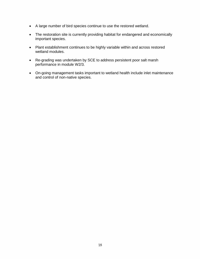
3.3 On-going Management Tasks There are important on-going management tasks associated with ensuring that the restoration project is successful. One task concerns inlet maintenance. Inlet closure can adversely affect dissolved oxygen concentration in the lagoon. Low dissolved oxygenconcentrations can lead to invertebrate and fish kills. In addition, partial blockage of the inlet by sand can affect drainage during low tides, resulting in the death of cordgrass, which requires good tidal flushing and cannot tolerate continued submergence. SCE has an inlet maintenance plan that will keep the inlet open to avoid degradation in water quality, ponding, and loss of biological resources (Elwany et al. 1998). Another on-going management task pertains to the control of non-native plants, which are present around the edges of the restoration site. Some non-native species such as Tamarisk can tolerate high soil salinity and could move into the restoration site. Indeed, Tamarisk has recruited into the restoration site, but was immediately removed (Fig. 3.2.6). SCE currently has an active weed abatement program to control weeds on the berms and disposal sites.
Figure 3.2.6. Tamarisk is a non-native plant that can invade salt marsh habitat. This specimen was removed from the tidal marsh by Steve Schroeter, CCC Contract Scientist. 3.4 Summary and Key Findings for 2013
The restored San Dieguito Wetlands have been colonized by salt marsh vegetation,
invertebrates, fish, and eelgrass.
18
A large number of bird species continue to use the restored wetland.
The restoration site is currently providing habitat for endangered and economically important species.
Plant establishment continues to be highly variable within and across restored wetland modules.
Re-grading was undertaken by SCE to address persistent poor salt marsh performance in module W2/3.
On-going management tasks important to wetland health include inlet maintenance and control of non-native species.
19
4.0 Methods of Project Evaluation
4.1 Monitoring Plan Condition A of the SONGS permit requires that monitoring of the wetland restoration be done over the full operating life of SONGS Units 2 and 3, which encompasses past and future years of operation of SONGS units 2 and 3 as well as the decommissioning period to the extent there are continuing circulating pump discharges. This monitoring will be done to measure compliance of the mitigation project with the performance standards specified in the SONGS permit. In accordance with Condition D (Administrative Structure) of the permit, contract scientists retained by the Executive Director developed the Monitoring Plan to guide the monitoring work and will oversee the monitoring studies outlined in the Plan. The SONGS permit provides a description of the performance standards and monitoring required for the wetland mitigation project. The Monitoring Plan includes a description of each performance standard and the methods that will be used to determine whether the various performance standards have been met.
A Draft Monitoring Plan for the SONGS Wetland Mitigation Program was reviewed by State and Federal agencies and SCE in May 2005. A revised Monitoring Plan was part of the coastal development permit (No. 6-04-88) for the wetland restoration project considered and approved by the Commission on October 12, 2005. The Monitoring Plan has subsequently been updated in June and October 2011 and July 2014 and will continue to be refined as more information becomes available pertaining to the logistics of sampling and methods of evaluating the performance standards.
4.2 Performance Standards Performance standards specified in Condition A of the SONGS permit are used to evaluate the success of the San Dieguito Wetlands Restoration Project in meeting the intended out-of-kind compensation for impacts to fish populations in the Southern California Bight due to SONGS operations. Monitoring independent of the permittee is done in accordance with Condition D of the SONGS permit to: (1) determine whether the performance standards established for Condition A are met, (2) determine, if necessary, the reasons why any performance standard has not been met, and (3) develop recommendations for appropriate remedial measures that may be required. The performance standards that will be used to measure the success of the wetland restoration project fall into two categories: absolute standards that are evaluated only in the San Dieguito Wetlands, and relative standards, which require that the value of the variable of interest be similar to that measured in reference wetlands in the region. The performance standards include long-term physical standards pertaining to topography (erosion, sedimentation), water quality (e.g., oxygen concentration), tidal prism, and habitat areas, and biological performance standards pertaining to biological communities (e.g., fish, invertebrates, and birds), marsh vegetation, Spartina canopy architecture, reproductive success of marsh plants, food chain support functions, and exotic species. The evaluation of each absolute performance standard in any given year is assessed by 1) a comparison of the value obtained from monitoring to a fixed value (e.g., for Habitat Areas, Tidal Prism) or 2) using best professional judgment (Topography). All absolute standards must be met in a year in order for that year to count towards compliance with Condition A. The evaluation of each relative performance standard is based on a four-year running
20
average calculated from data collected at the San Dieguito Wetlands for that year and the previous three years, similar in approach to that used to evaluate success of the Wheeler North Artificial Reef. Use of the short-term (4-year) running average accounts for natural variation in time that could affect compliance of the restoration site relative to the reference wetlands. For example, invertebrate, fish, and bird populations can vary in their species composition and abundance year to year and given this variation it is likely that the reference wetlands would not consistently meet all the relative standards in a given year. 4.3 Reference Wetlands The SONGS permit specifies that successful achievement of the performance standards will in some cases be measured relative to reference wetlands. Ideally, the biological assemblages in a successfully restored wetland should vary in a manner similar to those in the natural wetlands used for reference. Temporal variability, especially of the sort associated with weather (e.g., air temperature, rainfall) or oceanographic (e.g., swell height, water temperature) conditions can be accounted for by sampling the restored and natural reference wetlands concurrently. Concurrent monitoring of the restored and natural wetlands will help ensure that regional changes in weather and oceanographic conditions affecting the restored wetland will be reflected in the performance standards, since nearby reference wetlands will be subjected to similar conditions. The permit requires that the wetlands chosen for reference be relatively undisturbed, natural tidal wetlands within the Southern California Bight. Relatively undisturbed wetlands have minimal human disturbance to habitats (e.g., trampling of vegetation, boating, fishing). Natural tidal wetlands appropriate as reference sites are not constructed or substantially restored, are continuously open to the ocean, and receive regular tidal inundation. The Southern California Bight extends from Pt Conception to the US/Mexico border. After evaluating more than 40 wetlands within the Southern California Bight, three wetlands, Tijuana River Estuary, Mugu Lagoon, and Carpinteria Salt Marsh were chosen as reference wetlands that best met the criteria of undisturbed, natural tidal wetlands within the Southern California Bight. 4.4 Determination of similarity A requirement of the SONGS permit is that the response variables used to assess the relative performance standards of the San Dieguito Wetlands Restoration Project (hereafter referred to as “relative performance variables”) be “similar” to those of the reference wetlands. Evaluating whether a particular relative performance variable at the San Dieguito Wetlands Restoration Project is similar to the reference wetlands requires that two conditions be met. The first condition requires that the mean value for the performance variable at San Dieguito Wetlands not be significantly worse than the mean value at the three reference wetlands. A one sample, one tailed approach is used to evaluate all such comparisons. Significance is determined using an approach that utilizes both a formal probability value and an effect size. Generally this is done by means of a t-test except in the case of the performance standards pertaining to Vegetation and Algae. For these standards, only the mean values are compared because the values are wetland wide estimates made using aerial imagery and thus there are no estimates of variability about a mean value. The performance for a particular relative performance variable at San Dieguito Wetlands is considered to be worse than the lower of the three reference wetlands if the p-value for the comparison is ≤ the proportional effect size (i.e., the proportional difference between San Dieguito Wetlands and the lowest performing reference wetland). The only
21
exception to this rule is when the p-value and the proportional effect size are both greater than 0.5 in which case assessment for the period is considered inconclusive and additional studies will be done. As an example, if the proportional effect size for a given performance variable was 0.25 (i.e., the mean value at San Dieguito Wetlands was 75% of the mean value at the worst of the three reference wetlands), then a t-test yielding a p-value ≤ 0.25 would indicate the San Dieguito Wetlands Restoration did not meet the performance standard, whereas p-values > 0.25 would indicate that it did meet the performance standard. More details concerning the approach and the rational for determining similarity are provided in the Monitoring Plan for the SONGS Wetland Mitigation Project (Page et al. 2014).
The rationale for using the mean value of the worst performing of the reference wetlands is that the reference wetlands are considered to be acceptable standards of comparison for the San Dieguito Wetlands. Hence if the San Dieguito Wetlands Restoration is performing at least as well as one of the reference wetlands, then it should be judged successful. The scaling of the p-value (α) to the effect size recognizes sampling error when estimating mean values and balances the probability of falsely concluding that the San Dieguito Wetlands Restoration is not similar to the reference wetlands when it is (Type I error) with the probability of falsely concluding that the San Dieguito Wetlands Restoration is not similar to the reference wetlands when it is not (Type II error). To ensure that the San Dieguito Wetlands are not held to a higher standard than the reference wetlands the above procedure is also applied to the three reference wetlands (Tijuana Estuary, Mugu Lagoon, and Carpinteria Salt Marsh) to evaluate whether they would have met the relative performance standards. This is done by treating Tijuana Estuary, for example, as the mitigation wetland and using the other wetlands as the three reference wetlands. The San Dieguito Wetlands are considered similar to the reference wetlands if the proportion of relative standards met by the San Dieguito Wetlands is equal to or greater than the proportion of relative standards met by any of the reference wetlands. The above approach ensures that the assessment of similarity is consistent with the SONGS permit requirement that the performance standards be met without the unreasonable requirement that the San Dieguito Wetlands outperform Tijuana Estuary, Mugu Lagoon, and Carpinteria Salt Marsh for every performance standard. Importantly, this approach deals realistically with the inherent variability of nature in a manner that best serves the interests of the public and SCE.
22
5.0 Progress Report on the San Dieguito Wetlands Restoration Project
Listed below are the performance standards that are used to evaluate whether the San
Dieguito Wetlands Restoration meets the goals and objectives of the wetland mitigation set
forth in Condition A of the SONGS coastal development permit; the methods used to
evaluate each performance standard; and the results from the second year of monitoring.
More detailed methods can be found in The Monitoring Plan for the SONGS Wetland
Mitigation Project (Page et al. 2014).
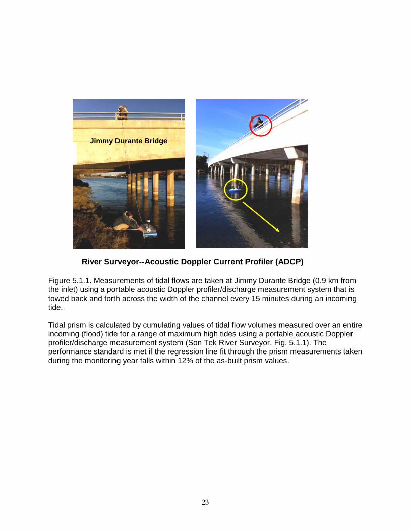
5.1 Absolute Performance Standards Tidal prism THE DESIGNED TIDAL PRISM SHALL BE MAINTAINED, AND TIDAL FLUSHING SHALL NOT BE INTERRUPTED. Approach: The tidal prism standard, as an absolute standard, is applied only to the San Dieguito Wetlands restoration. The tidal prism is the amount of water that flows into and out of an estuary with the flood and ebb of the tide, excluding any contribution from freshwater inflows (Hume 2005). Numerical modeling suggested that after restoration, the tidal prism in the lagoon would increase. However, predictions of tidal prism from this modeling are likely to differ from actual values for the as-built wetland since they do not include the effects of friction, which could contribute to a smaller than predicted tidal prism and are not based on the actual as-built topography. Therefore, the tidal prism of the restored wetland was measured on completion of construction in July 2012 and used as the standard of comparison to detect changes in this performance variable during subsequent monitoring. Since tidal prism can influence the area of wetland habitat inundated by the tides, the tidal prism standard is evaluated, in part, using criteria set forth in the habitat areas standard, which provides that the areas of the different habitats (subtidal, intertidal mudflat, vegetated salt marsh) shall not vary by more than 10%. The planned tidal volume-elevation relationship indicated that a decrease in tidal prism of greater than 12% could result in a reduction in the area of tidally inundated planned salt marsh habitat (1.3 to 4.5’ NGVD) of greater than 10%. Since the area of planned intertidal salt marsh habitat may not differ by more than 10% from the as-built area (see section Habitat Areas below), the tidal prism can not be less than 88% of the as-built prism to ensure no more than 10% of planned salt marsh habitat remains exposed during a 4.5’ tide. However, since a larger than planned tidal prism could increase erosion within the restored wetland, the prism shall also not be larger than 112% of the as-built prism.
23
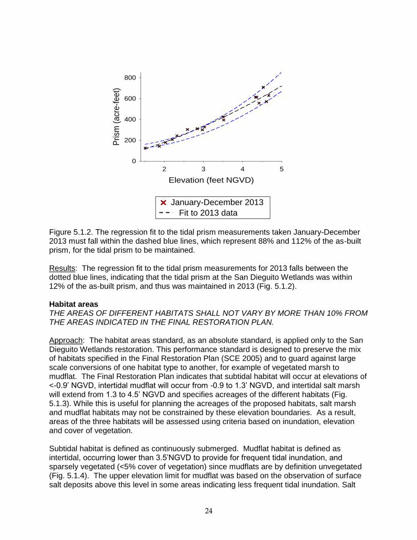
Figure 5.1.1. Measurements of tidal flows are taken at Jimmy Durante Bridge (0.9 km from the inlet) using a portable acoustic Doppler profiler/discharge measurement system that is towed back and forth across the width of the channel every 15 minutes during an incoming tide. Tidal prism is calculated by cumulating values of tidal flow volumes measured over an entire incoming (flood) tide for a range of maximum high tides using a portable acoustic Doppler profiler/discharge measurement system (Son Tek River Surveyor, Fig. 5.1.1). The performance standard is met if the regression line fit through the prism measurements taken during the monitoring year falls within 12% of the as-built prism values.
River Surveyor--Acoustic Doppler Current Profiler (ADCP)
Jimmy Durante Bridge
24
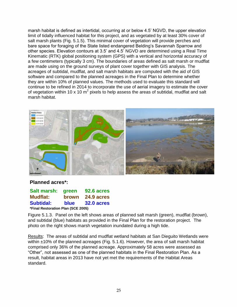
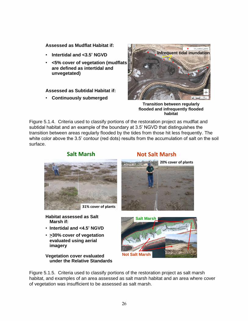
Figure 5.1.2. The regression fit to the tidal prism measurements taken January-December 2013 must fall within the dashed blue lines, which represent 88% and 112% of the as-built prism, for the tidal prism to be maintained. Results: The regression fit to the tidal prism measurements for 2013 falls between the dotted blue lines, indicating that the tidal prism at the San Dieguito Wetlands was within 12% of the as-built prism, and thus was maintained in 2013 (Fig. 5.1.2). Habitat areas THE AREAS OF DIFFERENT HABITATS SHALL NOT VARY BY MORE THAN 10% FROM THE AREAS INDICATED IN THE FINAL RESTORATION PLAN. Approach: The habitat areas standard, as an absolute standard, is applied only to the San Dieguito Wetlands restoration. This performance standard is designed to preserve the mix of habitats specified in the Final Restoration Plan (SCE 2005) and to guard against large scale conversions of one habitat type to another, for example of vegetated marsh to mudflat. The Final Restoration Plan indicates that subtidal habitat will occur at elevations of <-0.9’ NGVD, intertidal mudflat will occur from -0.9 to 1.3’ NGVD, and intertidal salt marsh will extend from 1.3 to 4.5’ NGVD and specifies acreages of the different habitats (Fig. 5.1.3). While this is useful for planning the acreages of the proposed habitats, salt marsh and mudflat habitats may not be constrained by these elevation boundaries. As a result, areas of the three habitats will be assessed using criteria based on inundation, elevation and cover of vegetation. Subtidal habitat is defined as continuously submerged. Mudflat habitat is defined as intertidal, occurring lower than 3.5’NGVD to provide for frequent tidal inundation, and sparsely vegetated (<5% cover of vegetation) since mudflats are by definition unvegetated (Fig. 5.1.4). The upper elevation limit for mudflat was based on the observation of surface salt deposits above this level in some areas indicating less frequent tidal inundation. Salt
January-December 2013
Fit to 2013 data
Elevation (feet NGVD)
2 3 4 5
Prism
(acr
e-f
eet)
0
200
400
600
800
25
marsh habitat is defined as intertidal, occurring at or below 4.5’ NGVD, the upper elevation limit of tidally influenced habitat for this project, and as vegetated by at least 30% cover of salt marsh plants (Fig. 5.1.5). This minimal cover of vegetation will provide perches and bare space for foraging of the State listed endangered Belding’s Savannah Sparrow and other species. Elevation contours at 3.5’ and 4.5’ NGVD are determined using a Real Time Kinematic (RTK) global positioning system (GPS) with a vertical and horizontal accuracy of a few centimeters (typically 3 cm). The boundaries of areas defined as salt marsh or mudflat are made using on the ground surveys of plant cover together with GIS analysis. The acreages of subtidal, mudflat, and salt marsh habitats are computed with the aid of GIS software and compared to the planned acreages in the Final Plan to determine whether they are within 10% of planned values. The methods used to evaluate this standard will continue to be refined in 2014 to incorporate the use of aerial imagery to estimate the cover of vegetation within 10 x 10 m
2 pixels to help assess the areas of subtidal, mudflat and salt
marsh habitat.
Figure 5.1.3. Panel on the left shows areas of planned salt marsh (green), mudflat (brown),
and subtidal (blue) habitats as provided in the Final Plan for the restoration project. The
photo on the right shows marsh vegetation inundated during a high tide.
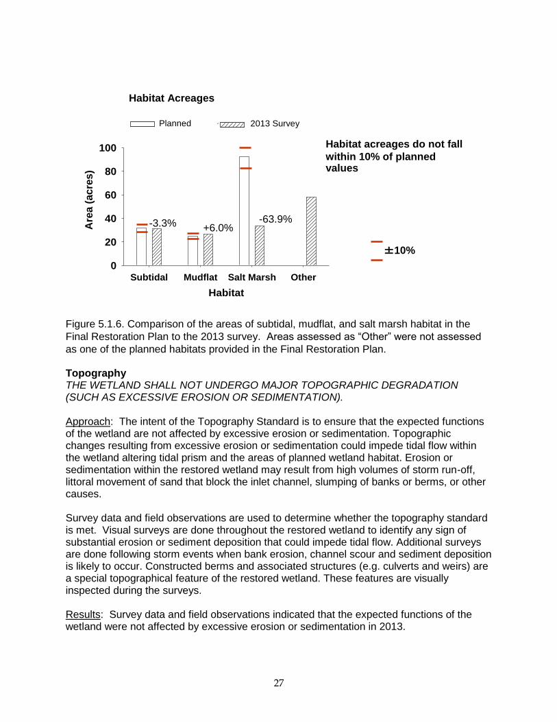
Results: The areas of subtidal and mudflat wetland habitats at San Dieguito Wetlands were
within ±10% of the planned acreages (Fig. 5.1.6). However, the area of salt marsh habitat
comprised only 36% of the planned acreage. Approximately 58 acres were assessed as
“Other”, not assessed as one of the planned habitats in the Final Restoration Plan. As a
result, habitat areas in 2013 have not yet met the requirements of the Habitat Areas
standard.
Planned acres*:
Salt marsh: green 92.6 acres
Mudflat: brown 24.9 acres
Subtidal: blue 32.0 acres*Final Restoration Plan (SCE 2005)
26
Figure 5.1.4. Criteria used to classify portions of the restoration project as mudflat and
subtidal habitat and an example of the boundary at 3.5’ NGVD that distinguishes the
transition between areas regularly flooded by the tides from those hit less frequently. The
white color above the 3.5’ contour (red dots) results from the accumulation of salt on the soil
surface.
Figure 5.1.5. Criteria used to classify portions of the restoration project as salt marsh
habitat, and examples of an area assessed as salt marsh habitat and an area where cover
of vegetation was insufficient to be assessed as salt marsh.
Assessed as Mudflat Habitat if:
• Intertidal and <3.5’ NGVD
• <5% cover of vegetation (mudflats
are defined as intertidal and unvegetated)
Assessed as Subtidal Habitat if:
• Continuously submerged
Assessment of Mudflat & Subtidal Habitat
Infrequent tidal inundation
Transition between regularly
flooded and infrequently flooded habitat
31% cover of plants
20% cover of plants
Not Salt MarshSalt Marsh
Habitat assessed as Salt Marsh if:
• Intertidal and <4.5’ NGVD
• >30% cover of vegetation
evaluated using aerial imagery
Vegetation cover evaluated under the Relative Standards
Not Salt Marsh
Salt Marsh
27
Figure 5.1.6. Comparison of the areas of subtidal, mudflat, and salt marsh habitat in the
Final Restoration Plan to the 2013 survey. Areas assessed as “Other” were not assessed
as one of the planned habitats provided in the Final Restoration Plan. Topography THE WETLAND SHALL NOT UNDERGO MAJOR TOPOGRAPHIC DEGRADATION (SUCH AS EXCESSIVE EROSION OR SEDIMENTATION). Approach: The intent of the Topography Standard is to ensure that the expected functions of the wetland are not affected by excessive erosion or sedimentation. Topographic changes resulting from excessive erosion or sedimentation could impede tidal flow within the wetland altering tidal prism and the areas of planned wetland habitat. Erosion or sedimentation within the restored wetland may result from high volumes of storm run-off, littoral movement of sand that block the inlet channel, slumping of banks or berms, or other causes. Survey data and field observations are used to determine whether the topography standard is met. Visual surveys are done throughout the restored wetland to identify any sign of substantial erosion or sediment deposition that could impede tidal flow. Additional surveys are done following storm events when bank erosion, channel scour and sediment deposition is likely to occur. Constructed berms and associated structures (e.g. culverts and weirs) are a special topographical feature of the restored wetland. These features are visually inspected during the surveys. Results: Survey data and field observations indicated that the expected functions of the wetland were not affected by excessive erosion or sedimentation in 2013.
Habitat
Subtidal Mudflat Salt Marsh Other
Are
a (
ac
res
)
0
20
40
60
80
100
±10%
Habitat acreages do not fall
within 10% of planned values
Planned 2013 Survey
Habitat Acreages
-3.3% +6.0%-63.9%
28
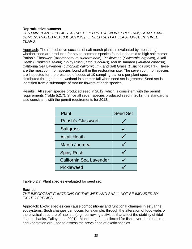
Reproductive success CERTAIN PLANT SPECIES, AS SPECIFIED IN THE WORK PROGRAM, SHALL HAVE DEMONSTRATED REPRODUCTION (I.E. SEED SET) AT LEAST ONCE IN THREE YEARS. Approach: The reproductive success of salt marsh plants is evaluated by measuring whether seed are produced for seven common species found in the mid to high salt marsh: Parish’s Glasswort (Arthrocnemum subterminale), Pickleweed (Salicornia virginica), Alkali Heath (Frankenia salina), Spiny Rush (Juncus acutus), Marsh Jaumea (Jaumea carnosa), California Sea Lavender (Limonium californicum), and Salt Grass (Distichlis spicata). These are the most common species found within the restoration site. The seven common species are inspected for the presence of seeds at 10 sampling stations per plant species distributed throughout the wetland in summer-fall when seed set is greatest. Seed set is identified from a subsample of mature flowers of each species. Results: All seven species produced seed in 2012, which is consistent with the permit requirements (Table 5.2.7). Since all seven species produced seed in 2012, the standard is also consistent with the permit requirements for 2013.
Table 5.2.7. Plant species evaluated for seed set. Exotics THE IMPORTANT FUNCTIONS OF THE WETLAND SHALL NOT BE IMPAIRED BY EXOTIC SPECIES. Approach: Exotic species can cause compositional and functional changes in estuarine ecosystems. Such changes can occur, for example, through the alteration of food webs or the physical structure of habitats (e.g., burrowing activities that affect the stability of tidal channel banks, Talley et al. 2001). Monitoring data collected for fish, invertebrates, birds, and vegetation are used to assess the prevalence of exotic species.
Parish’s Glasswort
Saltgrass
Alkali Heath
Marsh Jaumea
Spiny Rush
California Sea Lavender
Pickleweed
Plant Seed Set
Parish’s Glasswort
Saltgrass
Alkali Heath
Marsh Jaumea
Spiny Rush
California Sea Lavender
Pickleweed
Plant Seed Set
29
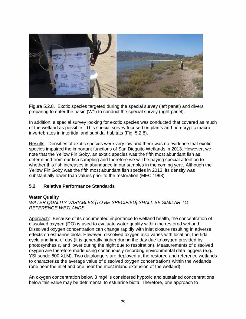
Figure 5.2.8. Exotic species targeted during the special survey (left panel) and divers preparing to enter the basin (W1) to conduct the special survey (right panel). In addition, a special survey looking for exotic species was conducted that covered as much of the wetland as possible.. This special survey focused on plants and non-cryptic macro invertebrates in intertidal and subtidal habitats (Fig. 5.2.8). Results: Densities of exotic species were very low and there was no evidence that exotic species impaired the important functions of San Dieguito Wetlands in 2013. However, we note that the Yellow Fin Goby, an exotic species was the fifth most abundant fish as determined from our fish sampling and therefore we will be paying special attention to whether this fish increases in abundance in our samples in the coming year. Although the Yellow Fin Goby was the fifth most abundant fish species in 2013, its density was substantially lower than values prior to the restoration (MEC 1993). 5.2 Relative Performance Standards
Water Quality WATER QUALITY VARIABLES [TO BE SPECIFIED] SHALL BE SIMILAR TO REFERENCE WETLANDS. Approach: Because of its documented importance to wetland health, the concentration of dissolved oxygen (DO) is used to evaluate water quality within the restored wetland. Dissolved oxygen concentration can change rapidly with inlet closure resulting in adverse effects on estuarine biota. However, dissolved oxygen also varies with location, the tidal cycle and time of day (it is generally higher during the day due to oxygen provided by photosynthesis, and lower during the night due to respiration). Measurements of dissolved oxygen are therefore made using continuously recording environmental data loggers (e.g., YSI sonde 600 XLM). Two dataloggers are deployed at the restored and reference wetlands to characterize the average value of dissolved oxygen concentrations within the wetlands (one near the inlet and one near the most inland extension of the wetland). An oxygen concentration below 3 mg/l is considered hypoxic and sustained concentrations below this value may be detrimental to estuarine biota. Therefore, one approach to
30
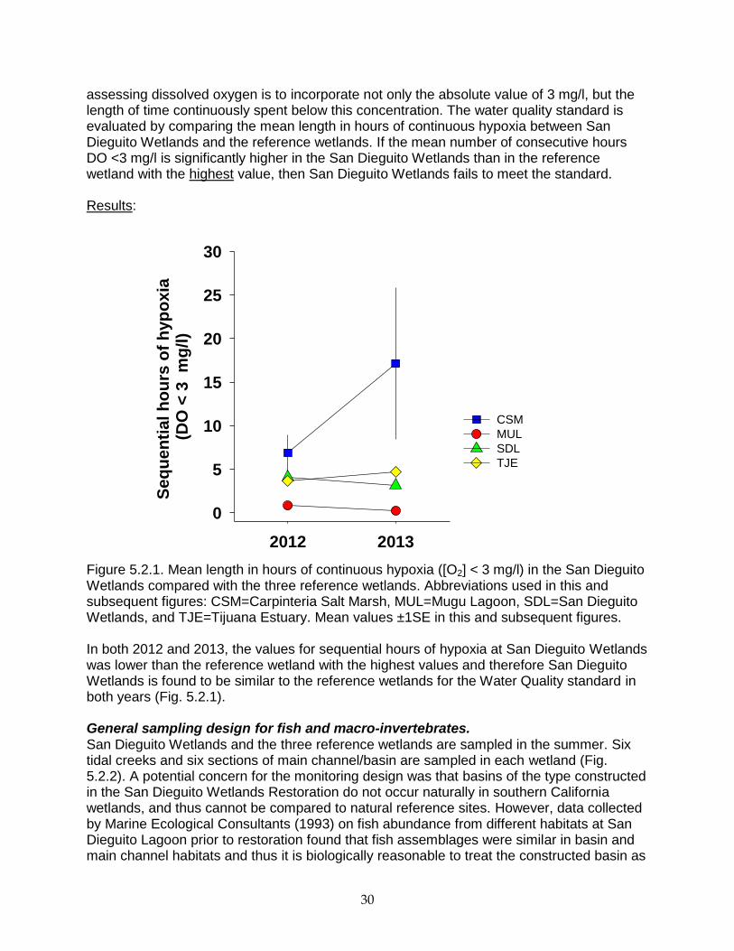
assessing dissolved oxygen is to incorporate not only the absolute value of 3 mg/l, but the length of time continuously spent below this concentration. The water quality standard is evaluated by comparing the mean length in hours of continuous hypoxia between San Dieguito Wetlands and the reference wetlands. If the mean number of consecutive hours DO <3 mg/l is significantly higher in the San Dieguito Wetlands than in the reference wetland with the highest value, then San Dieguito Wetlands fails to meet the standard. Results:
Figure 5.2.1. Mean length in hours of continuous hypoxia ([O2] < 3 mg/l) in the San Dieguito Wetlands compared with the three reference wetlands. Abbreviations used in this and subsequent figures: CSM=Carpinteria Salt Marsh, MUL=Mugu Lagoon, SDL=San Dieguito Wetlands, and TJE=Tijuana Estuary. Mean values ±1SE in this and subsequent figures. In both 2012 and 2013, the values for sequential hours of hypoxia at San Dieguito Wetlands was lower than the reference wetland with the highest values and therefore San Dieguito Wetlands is found to be similar to the reference wetlands for the Water Quality standard in both years (Fig. 5.2.1). General sampling design for fish and macro-invertebrates. San Dieguito Wetlands and the three reference wetlands are sampled in the summer. Six tidal creeks and six sections of main channel/basin are sampled in each wetland (Fig. 5.2.2). A potential concern for the monitoring design was that basins of the type constructed in the San Dieguito Wetlands Restoration do not occur naturally in southern California wetlands, and thus cannot be compared to natural reference sites. However, data collected by Marine Ecological Consultants (1993) on fish abundance from different habitats at San Dieguito Lagoon prior to restoration found that fish assemblages were similar in basin and main channel habitats and thus it is biologically reasonable to treat the constructed basin as
2012 2013
Se
qu
en
tial
ho
urs
of
hyp
ox
ia
(DO
< 3
m
g/l
)
0
5
10
15
20
25
30
CSM
MUL
SDL
TJE
31
main channel habitat in post-construction monitoring. The sampled creeks or sections of main channel/basin are treated as replicates in subsequent analysis. Because tidal creeks and main channels differ in width, water depth, and hydrology, and are thus the likely to support different assemblages of fish and macro-invertebrates, tidal creeks and main channels are assessed separately.
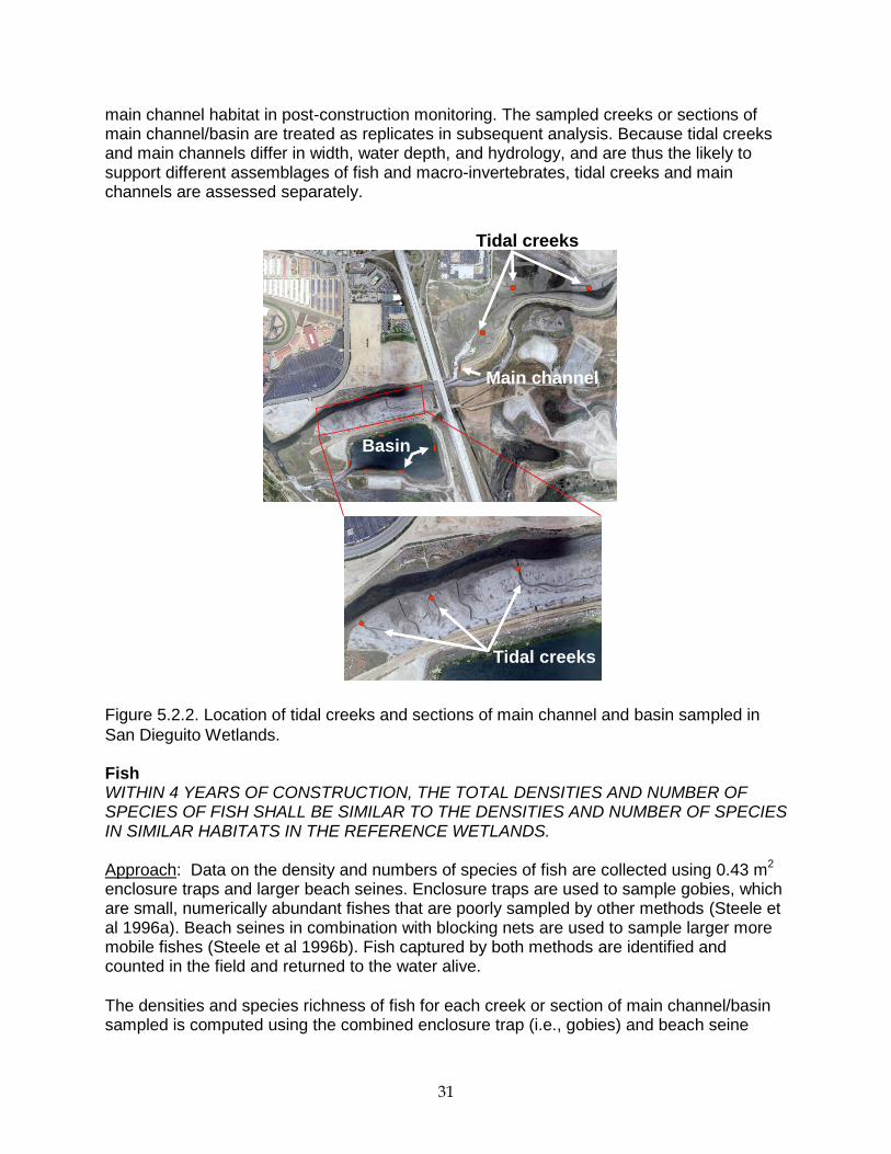
Figure 5.2.2. Location of tidal creeks and sections of main channel and basin sampled in
San Dieguito Wetlands. Fish WITHIN 4 YEARS OF CONSTRUCTION, THE TOTAL DENSITIES AND NUMBER OF SPECIES OF FISH SHALL BE SIMILAR TO THE DENSITIES AND NUMBER OF SPECIES IN SIMILAR HABITATS IN THE REFERENCE WETLANDS. Approach: Data on the density and numbers of species of fish are collected using 0.43 m
2
enclosure traps and larger beach seines. Enclosure traps are used to sample gobies, which are small, numerically abundant fishes that are poorly sampled by other methods (Steele et al 1996a). Beach seines in combination with blocking nets are used to sample larger more mobile fishes (Steele et al 1996b). Fish captured by both methods are identified and counted in the field and returned to the water alive.
The densities and species richness of fish for each creek or section of main channel/basin sampled is computed using the combined enclosure trap (i.e., gobies) and beach seine
Tidal creeks
Basin
Tidal creeks
Main channel
32
(excluding gobies) samples. Density and species richness values averaged across the six creeks or six sections of main channel/basin are used to compare wetlands. Clapper Rail nesting in Tijuana Estuary prevented sampling using seines in 2012 so only data collected using enclosure traps from San Dieguito Wetlands and the reference sites were used to assess the density and species richness of wetland fish for that year. Monitoring was rescheduled to the early fall in 2013 to avoid Clapper Rail nesting season, therefore data in 2013 include both enclosure traps and seines in all of the wetlands. Results:
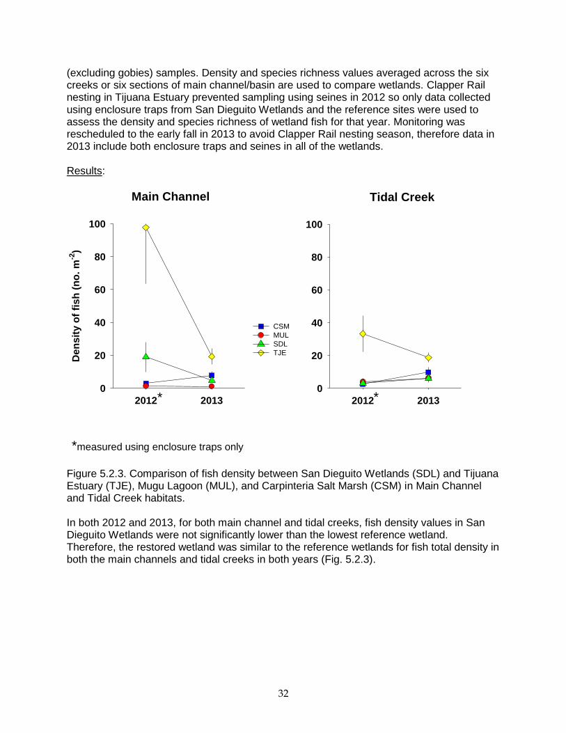
Figure 5.2.3. Comparison of fish density between San Dieguito Wetlands (SDL) and Tijuana Estuary (TJE), Mugu Lagoon (MUL), and Carpinteria Salt Marsh (CSM) in Main Channel and Tidal Creek habitats.
In both 2012 and 2013, for both main channel and tidal creeks, fish density values in San Dieguito Wetlands were not significantly lower than the lowest reference wetland. Therefore, the restored wetland was similar to the reference wetlands for fish total density in both the main channels and tidal creeks in both years (Fig. 5.2.3).
Main Channel Tidal Creek
2012 2013
Den
sit
y o
f fi
sh
(n
o. m
-2)
0
20
40
60
80
100
CSM
MUL
SDL
TJE
2012 2013
0
20
40
60
80
100
* *
*measured using enclosure traps only
33
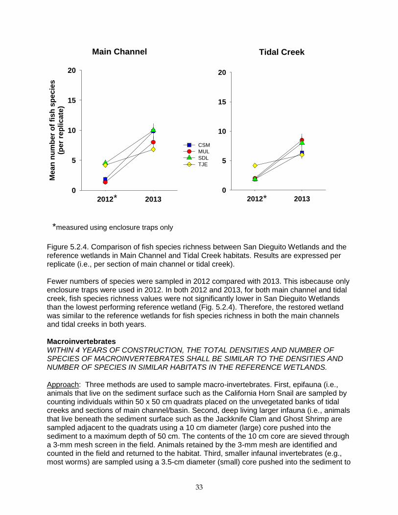
Figure 5.2.4. Comparison of fish species richness between San Dieguito Wetlands and the reference wetlands in Main Channel and Tidal Creek habitats. Results are expressed per replicate (i.e., per section of main channel or tidal creek). Fewer numbers of species were sampled in 2012 compared with 2013. This isbecause only enclosure traps were used in 2012. In both 2012 and 2013, for both main channel and tidal creek, fish species richness values were not significantly lower in San Dieguito Wetlands than the lowest performing reference wetland (Fig. 5.2.4). Therefore, the restored wetland was similar to the reference wetlands for fish species richness in both the main channels and tidal creeks in both years. Macroinvertebrates WITHIN 4 YEARS OF CONSTRUCTION, THE TOTAL DENSITIES AND NUMBER OF SPECIES OF MACROINVERTEBRATES SHALL BE SIMILAR TO THE DENSITIES AND NUMBER OF SPECIES IN SIMILAR HABITATS IN THE REFERENCE WETLANDS. Approach: Three methods are used to sample macro-invertebrates. First, epifauna (i.e., animals that live on the sediment surface such as the California Horn Snail are sampled by counting individuals within 50 x 50 cm
quadrats placed on the unvegetated banks of tidal
creeks and sections of main channel/basin. Second, deep living larger infauna (i.e., animals that live beneath the sediment surface such as the Jackknife Clam and Ghost Shrimp are sampled adjacent to the quadrats using a 10 cm diameter (large) core pushed into the sediment to a maximum depth of 50 cm. The contents of the 10 cm core are sieved through a 3-mm mesh screen in the field. Animals retained by the 3-mm mesh are identified and counted in the field and returned to the habitat. Third, smaller infaunal invertebrates (e.g., most worms) are sampled using a 3.5-cm diameter (small) core pushed into the sediment to
2012 2013
Me
an
nu
mb
er
of
fis
h s
pe
cie
s(p
er
rep
lica
te)
0
5
10
15
20
CSM
MUL
SDL
TJE
2012 2013
0
5
10
15
20
Main Channel Tidal Creek
*
*measured using enclosure traps only
*
34
a depth of 6 cm. The small core samples are taken adjacent to the large core samples and were preserved on site in 10% buffered formalin. The samples are returned to the laboratory where they are screened through a 0.5mm mesh. Biota retained on the screen are identified and counted.
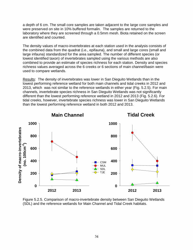
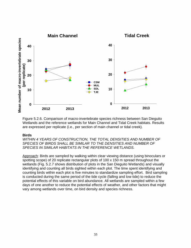
The density values of macro-invertebrates at each station used in the analysis consists of the combined data from the quadrat (i.e., epifauna), and small and large cores (small and large infauna) standardized for the area sampled. The number of different species (or lowest identified taxon) of invertebrates sampled using the various methods are also combined to provide an estimate of species richness for each station. Density and species richness values averaged across the 6 creeks or 6 sections of main channel/basin were used to compare wetlands. Results: The density of invertebrates was lower in San Dieguito Wetlands than in the lowest performing reference wetland for both main channels and tidal creeks in 2012 and 2013, which was not similar to the reference wetlands in either year (Fig. 5.2.5). For main channels, invertebrate species richness in San Dieguito Wetlands was not significantly different than the lowest performing reference wetland in 2012 and 2013 (Fig. 5.2.6). For tidal creeks, however, invertebrate species richness was lower in San Dieguito Wetlands than the lowest performing reference wetland in both 2012 and 2013.
Figure 5.2.5. Comparison of macro-invertebrate density between San Dieguito Wetlands (SDL) and the reference wetlands for Main Channel and Tidal Creek habitats.
Main Channel
2012 2013
Den
sit
y o
f m
acro
-in
vert
eb
rate
s
(no
. 100cm
-2)
0
200
400
600
800
1000
CSM
MUL
SDL
TJE
Tidal Creek
2012 2013
0
200
400
600
800
1000
35
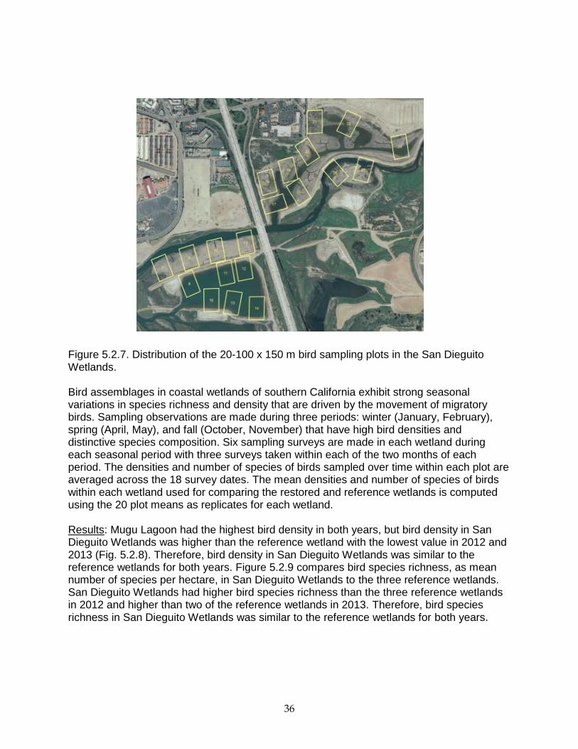
Figure 5.2.6. Comparison of macro-invertebrate species richness between San Dieguito Wetlands and the reference wetlands for Main Channel and Tidal Creek habitats. Results are expressed per replicate (i.e., per section of main channel or tidal creek). Birds WITHIN 4 YEARS OF CONSTRUCTION, THE TOTAL DENSITIES AND NUMBER OF SPECIES OF BIRDS SHALL BE SIMILAR TO THE DENSITIES AND NUMBER OF SPECIES IN SIMILAR HABITATS IN THE REFERENCE WETLANDS. Approach: Birds are sampled by walking within clear viewing distance (using binoculars or spotting scope) of 20 replicate rectangular plots of 100 x 150 m spread throughout the wetlands (Fig. 5.2.7 shows distribution of plots in the San Dieguito Wetlands) and visually identifying and counting all birds sighted within each plot. The time spent identifying and counting birds within each plot is five minutes to standardize sampling effort. Bird sampling is conducted during the same period of the tide cycle (falling and low tide) to reduce the potential effects of this variable on bird abundance. All wetlands are sampled within a few days of one another to reduce the potential effects of weather, and other factors that might vary among wetlands over time, on bird density and species richness.
Main Channel
2012 2013
Me
an
nu
mb
er
of
ma
cro
-in
ve
rte
bra
te s
pe
cie
s(p
er
rep
lic
ate
)
0
10
20
30
40
CSM
MUL
SDL
TJE
Tidal Creek
2012 2013
0
10
20
30
40
36
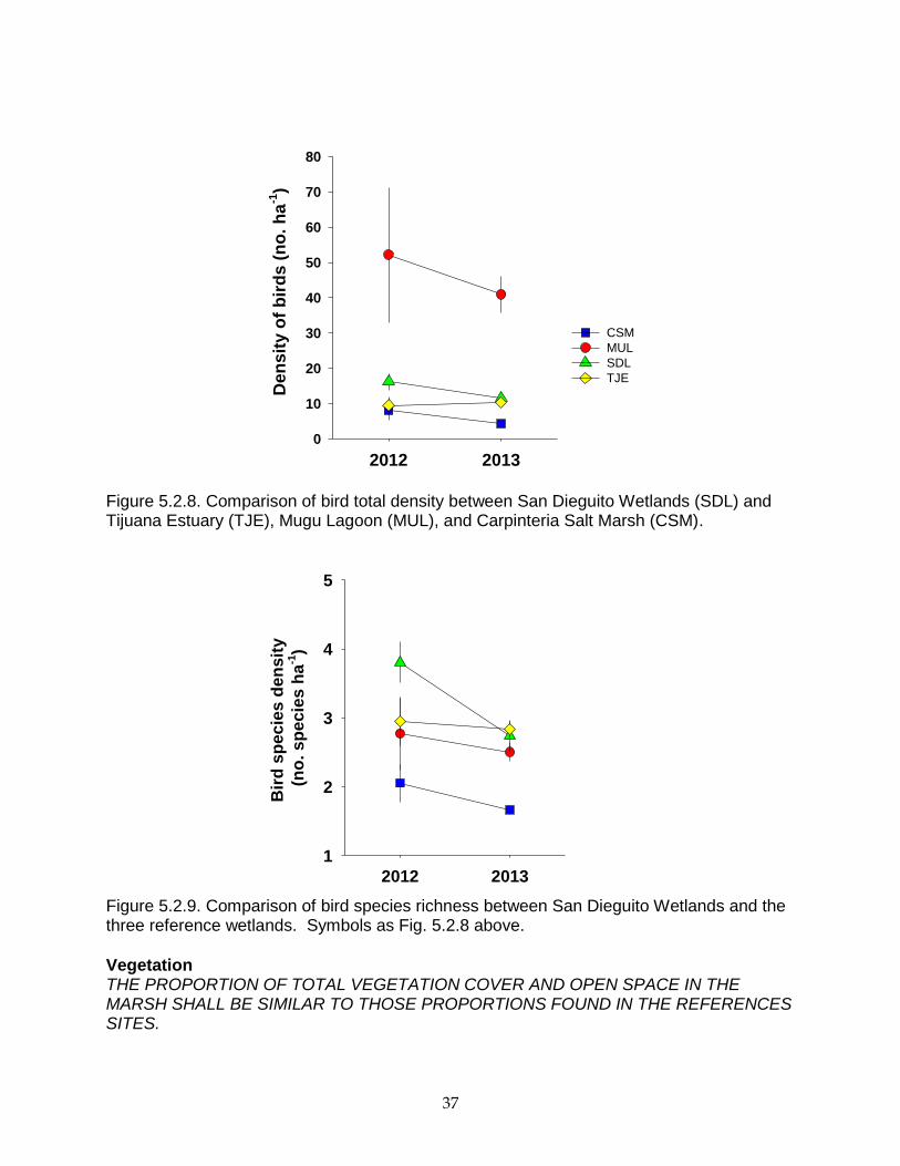
Figure 5.2.7. Distribution of the 20-100 x 150 m bird sampling plots in the San Dieguito Wetlands. Bird assemblages in coastal wetlands of southern California exhibit strong seasonal variations in species richness and density that are driven by the movement of migratory birds. Sampling observations are made during three periods: winter (January, February), spring (April, May), and fall (October, November) that have high bird densities and distinctive species composition. Six sampling surveys are made in each wetland during each seasonal period with three surveys taken within each of the two months of each period. The densities and number of species of birds sampled over time within each plot are averaged across the 18 survey dates. The mean densities and number of species of birds within each wetland used for comparing the restored and reference wetlands is computed using the 20 plot means as replicates for each wetland. Results: Mugu Lagoon had the highest bird density in both years, but bird density in San Dieguito Wetlands was higher than the reference wetland with the lowest value in 2012 and 2013 (Fig. 5.2.8). Therefore, bird density in San Dieguito Wetlands was similar to the reference wetlands for both years. Figure 5.2.9 compares bird species richness, as mean number of species per hectare, in San Dieguito Wetlands to the three reference wetlands. San Dieguito Wetlands had higher bird species richness than the three reference wetlands in 2012 and higher than two of the reference wetlands in 2013. Therefore, bird species richness in San Dieguito Wetlands was similar to the reference wetlands for both years.
37
Figure 5.2.8. Comparison of bird total density between San Dieguito Wetlands (SDL) and Tijuana Estuary (TJE), Mugu Lagoon (MUL), and Carpinteria Salt Marsh (CSM).
Figure 5.2.9. Comparison of bird species richness between San Dieguito Wetlands and the three reference wetlands. Symbols as Fig. 5.2.8 above.
Vegetation THE PROPORTION OF TOTAL VEGETATION COVER AND OPEN SPACE IN THE MARSH SHALL BE SIMILAR TO THOSE PROPORTIONS FOUND IN THE REFERENCES SITES.
2012 2013
De
ns
ity o
f b
ird
s (
no
. h
a-1
)
0
10
20
30
40
50
60
70
80
CSM
MUL
SDL
TJE
2012 2013
Bir
d s
pecie
s d
en
sit
y
(no
. sp
ecie
s h
a-1
)
1
2
3
4
5
CSM
MUL
SDL
TJE
38
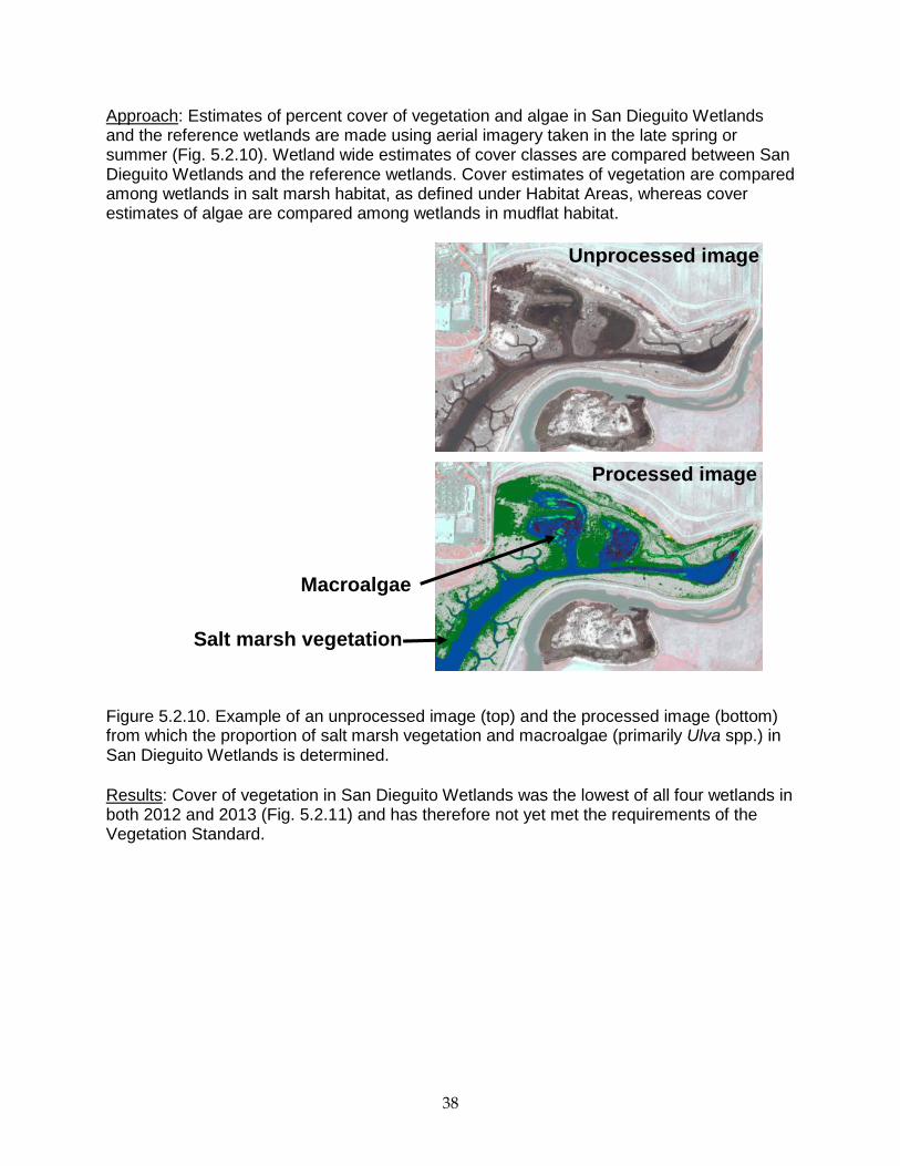
Approach: Estimates of percent cover of vegetation and algae in San Dieguito Wetlands and the reference wetlands are made using aerial imagery taken in the late spring or summer (Fig. 5.2.10). Wetland wide estimates of cover classes are compared between San Dieguito Wetlands and the reference wetlands. Cover estimates of vegetation are compared among wetlands in salt marsh habitat, as defined under Habitat Areas, whereas cover estimates of algae are compared among wetlands in mudflat habitat.
Figure 5.2.10. Example of an unprocessed image (top) and the processed image (bottom) from which the proportion of salt marsh vegetation and macroalgae (primarily Ulva spp.) in San Dieguito Wetlands is determined.
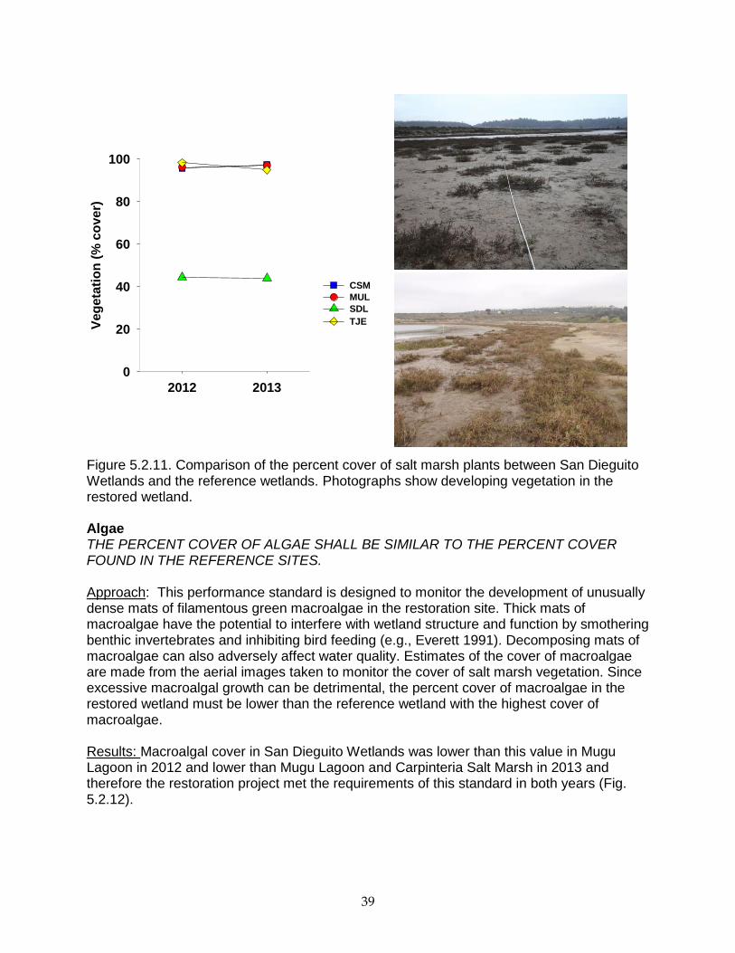
Results: Cover of vegetation in San Dieguito Wetlands was the lowest of all four wetlands in both 2012 and 2013 (Fig. 5.2.11) and has therefore not yet met the requirements of the Vegetation Standard.
Salt marsh vegetation
Macroalgae
Unprocessed image
Processed image
39
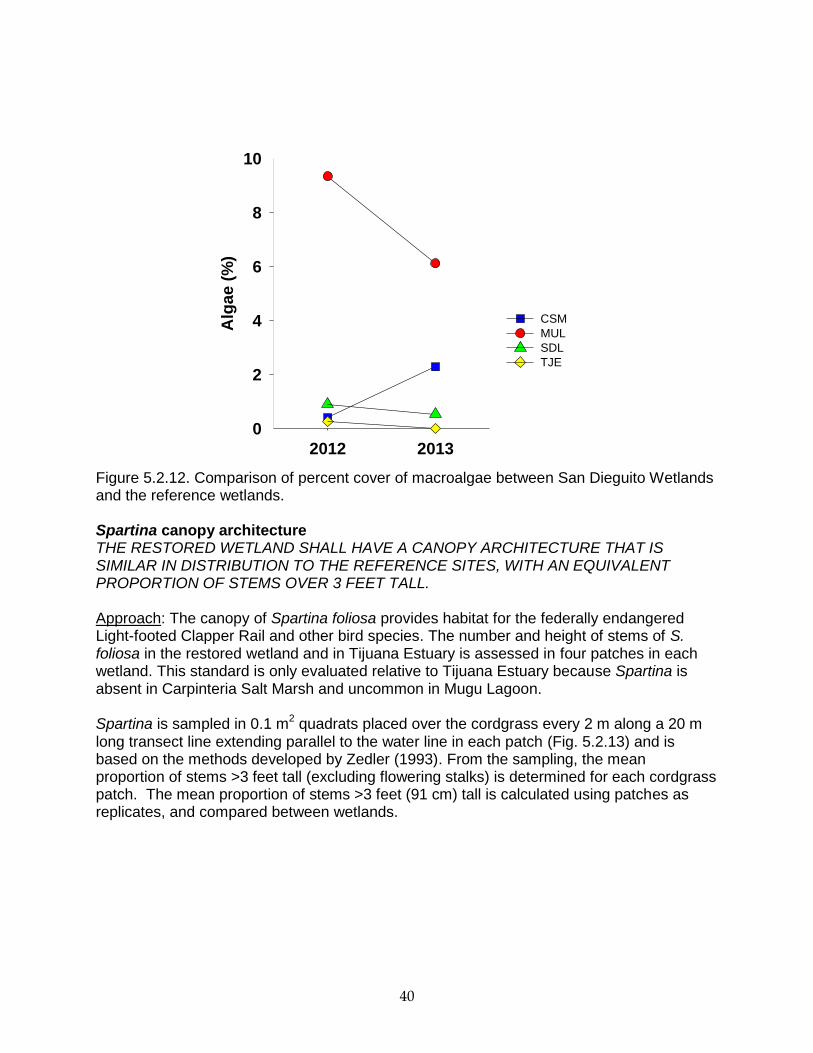
Figure 5.2.11. Comparison of the percent cover of salt marsh plants between San Dieguito Wetlands and the reference wetlands. Photographs show developing vegetation in the restored wetland. Algae THE PERCENT COVER OF ALGAE SHALL BE SIMILAR TO THE PERCENT COVER FOUND IN THE REFERENCE SITES. Approach: This performance standard is designed to monitor the development of unusually dense mats of filamentous green macroalgae in the restoration site. Thick mats of macroalgae have the potential to interfere with wetland structure and function by smothering benthic invertebrates and inhibiting bird feeding (e.g., Everett 1991). Decomposing mats of macroalgae can also adversely affect water quality. Estimates of the cover of macroalgae are made from the aerial images taken to monitor the cover of salt marsh vegetation. Since excessive macroalgal growth can be detrimental, the percent cover of macroalgae in the restored wetland must be lower than the reference wetland with the highest cover of macroalgae. Results: Macroalgal cover in San Dieguito Wetlands was lower than this value in Mugu Lagoon in 2012 and lower than Mugu Lagoon and Carpinteria Salt Marsh in 2013 and therefore the restoration project met the requirements of this standard in both years (Fig. 5.2.12).
2012 2013
Veg
eta
tio
n (
% c
over)
0
20
40
60
80
100
CSM
MUL
SDL
TJE
40
Figure 5.2.12. Comparison of percent cover of macroalgae between San Dieguito Wetlands and the reference wetlands. Spartina canopy architecture THE RESTORED WETLAND SHALL HAVE A CANOPY ARCHITECTURE THAT IS SIMILAR IN DISTRIBUTION TO THE REFERENCE SITES, WITH AN EQUIVALENT PROPORTION OF STEMS OVER 3 FEET TALL. Approach: The canopy of Spartina foliosa provides habitat for the federally endangered Light-footed Clapper Rail and other bird species. The number and height of stems of S. foliosa in the restored wetland and in Tijuana Estuary is assessed in four patches in each wetland. This standard is only evaluated relative to Tijuana Estuary because Spartina is absent in Carpinteria Salt Marsh and uncommon in Mugu Lagoon. Spartina is sampled in 0.1 m
2 quadrats placed over the cordgrass every 2 m along a 20 m
long transect line extending parallel to the water line in each patch (Fig. 5.2.13) and is based on the methods developed by Zedler (1993). From the sampling, the mean proportion of stems >3 feet tall (excluding flowering stalks) is determined for each cordgrass patch. The mean proportion of stems >3 feet (91 cm) tall is calculated using patches as replicates, and compared between wetlands.
2012 2013
Alg
ae (
%)
0
2
4
6
8
10
CSM
MUL
SDL
TJE
41
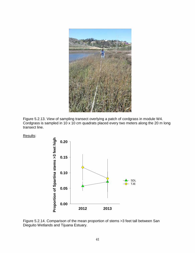
Figure 5.2.13. View of sampling transect overlying a patch of cordgrass in module W4. Cordgrass is sampled in 10 x 10 cm quadrats placed every two meters along the 20 m long transect line. Results:
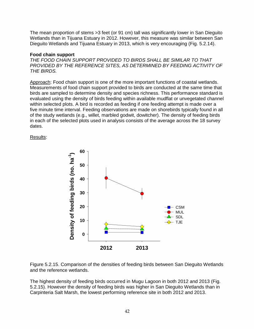
Figure 5.2.14. Comparison of the mean proportion of stems >3 feet tall between San Dieguito Wetlands and Tijuana Estuary.
2012 2013
Pro
po
rtio
n o
f S
pa
rtin
a s
t em
s >
3 f
eet
hig
h
0.00
0.05
0.10
0.15
0.20
SDL
TJE
42
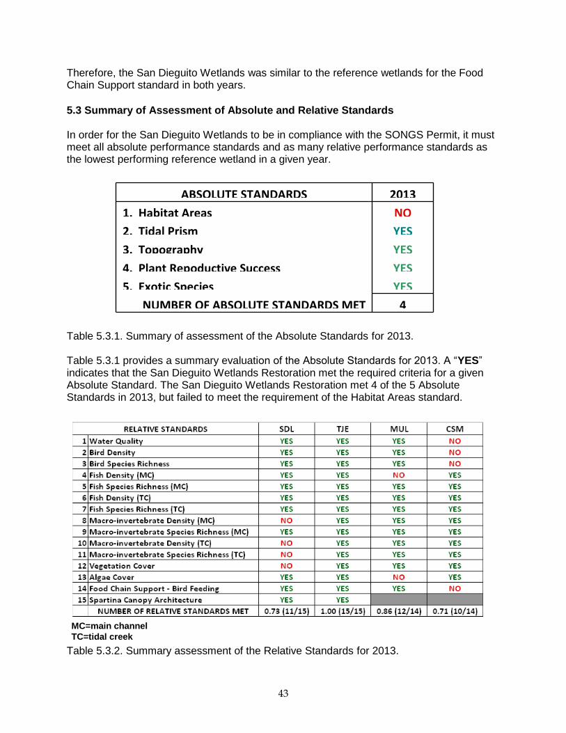
The mean proportion of stems >3 feet (or 91 cm) tall was significantly lower in San Dieguito Wetlands than in Tijuana Estuary in 2012. However, this measure was similar between San Dieguito Wetlands and Tijuana Estuary in 2013, which is very encouraging (Fig. 5.2.14). Food chain support THE FOOD CHAIN SUPPORT PROVIDED TO BIRDS SHALL BE SIMILAR TO THAT PROVIDED BY THE REFERENCE SITES, AS DETERMINED BY FEEDING ACTIVITY OF THE BIRDS. Approach: Food chain support is one of the more important functions of coastal wetlands. Measurements of food chain support provided to birds are conducted at the same time that birds are sampled to determine density and species richness. This performance standard is evaluated using the density of birds feeding within available mudflat or unvegetated channel within selected plots. A bird is recorded as feeding if one feeding attempt is made over a five minute time interval. Feeding observations are made on shorebirds typically found in all of the study wetlands (e.g., willet, marbled godwit, dowitcher). The density of feeding birds in each of the selected plots used in analysis consists of the average across the 18 survey dates. Results:
Figure 5.2.15. Comparison of the densities of feeding birds between San Dieguito Wetlands
and the reference wetlands.
The highest density of feeding birds occurred in Mugu Lagoon in both 2012 and 2013 (Fig. 5.2.15). However the density of feeding birds was higher in San Dieguito Wetlands than in Carpinteria Salt Marsh, the lowest performing reference site in both 2012 and 2013.
2012 2013
Den
sit
y o
f fe
ed
ing
bir
ds (
no
. h
a-1
)
0
10
20
30
40
50
60
CSM
MUL
SDL
TJE
43
Therefore, the San Dieguito Wetlands was similar to the reference wetlands for the Food Chain Support standard in both years.
5.3 Summary of Assessment of Absolute and Relative Standards In order for the San Dieguito Wetlands to be in compliance with the SONGS Permit, it must meet all absolute performance standards and as many relative performance standards as the lowest performing reference wetland in a given year.
Table 5.3.1. Summary of assessment of the Absolute Standards for 2013. Table 5.3.1 provides a summary evaluation of the Absolute Standards for 2013. A “YES” indicates that the San Dieguito Wetlands Restoration met the required criteria for a given Absolute Standard. The San Dieguito Wetlands Restoration met 4 of the 5 Absolute Standards in 2013, but failed to meet the requirement of the Habitat Areas standard.
Table 5.3.2. Summary assessment of the Relative Standards for 2013.
ABSOLUTE STANDARDS 2013
1. Habitat Areas NO
2. Tidal Prism YES
3. Topography YES
4. Plant Repoductive Success YES
5. Exotic Species YES
NUMBER OF ABSOLUTE STANDARDS MET 4
MC=main channel
TC=tidal creek
44
Table 5.3.2 provides a summary assessment of the relative performance standards for 2013. A “YES” indicates that the value for the indicated response variable at a particular wetland is similar to the other wetlands. A “NO” indicates that the indicated response variable was statistically worse than the other wetlands. The Tijuana Estuary was the best performing wetland with 15 of 15 standards receiving a “YES”, indicating that the value for these performance variables were as good, or better, than those in the other three wetlands. San Dieguito Wetlands received a higher proportion of “YES” than Carpinteria Salt Marsh, the reference site with the lowest proportion of “YES”, thereby meeting the relative performance standards in 2013. This is very encouraging given that this is only the second of monitoring post-construction.
6.0 Future Monitoring Plans Monitoring of the San Dieguito Wetlands, and the reference wetlands, Carpinteria Salt Marsh, Mugu Lagoon, and Tijuana Estuary will continue in 2014 using the same level of effort and methods employed in 2013. Standards in the San Dieguito Wetlands that will warrant close observation during the next year include macro-invertebrate density and species richness, and development of vegetation cover.
45
6.0 References
Elwany, H., R. Flick, and J. Reitzel. 1998. Inlet channel maintenance plan for restored San
Dieguito Lagoon. Prepared for Southern California Edison, Rosemead, California 91770, 1 June 1998, CE ref No. 98-8.
Everett, R. A. 1991. Intertidal distribution of infauna in a central California lagoon: the role of
seasonal blooms of macroalgae. Journal of Experimental Marine Biology and Ecology 150:223-247.
Hume, T. M. 2005. Tidal prism. In M. L. Schwartz (Ed.). Encyclopedia of Coastal Science.
Springer, Dordrecht, The Netherlands. MEC Analytical Systems, Inc. 1993. San Dieguito Lagoon Restoration Project Biological
Baseline Study, March 1992 - May 1993. Volume 1. Draft Technical Memorandum prepared for Southern California Edison.
Page, M., S. Schroeter, D. Reed, and M. Steele. 2014. Monitoring Plan for the SONGS’
Wetland Mitigation Project. Report to the California Coastal Commission. 247 pp. SCE (Southern California Edison Company). 2005. San Dieguito Wetlands Restoration
Project: Final Restoration Plan. Submitted to the California Coastal Commission, November 2005.
Steele, M. A, S. C. Schroeter, and H. M. Page. 2006a. Sampling characteristics and
biases of enclosure sampling fishes in estuaries. Estuaries and Coasts 29:630-638.
Steele, M. A, S. C. Schroeter, and H. M. Page. 2006a. Sampling characteristics and biases of enclosure sampling fishes in estuaries. Estuaries and Coasts 29:1172-1184.
Talley, T. S., J. A. Crooks, and L. A. Levin. 2001. Habitat utilization and alteration by the
invasive burrowing isopod, Sphaeroma quoyanum, in California salt marshes. Marine Biology 138:561-573.
Zedler, J. B 1993. Canopy architecture of natural and planted cordgrass marshes –
selecting habitat evaluation criteria. Ecological Applications 3:123-138.