Embed Size (px)
Citation preview


ii
ACKNOWLEDGEMENTS
This report, commissioned by the City
of Waterbury, contains a summary of
conceptual design plans developed
by The RBA Group for the Tiger
Grant Application of 2014. These
recommendations are an outgrowth of
the initial vision established in Phase
1 of the Waterbury Naugatuck River
Greenway plan.
PREPARED FORCity of Waterbury, CT
PREPARED BYThe RBA GroupNovember 2013
ii DRAFT
iii
EXECUTIVE SUMMARY.........................................................................................................
EXISTING CONDITIONS .......................................................................................................
TRAIL ROUTE ........................................................................................................................
A. Eagle Street to Washington Avenue (Naugatuck River / Mad River Connector)
B. Washington Avenue to Jackson Street (Anamet Connector Project)
C. Jackson Street to Freight Street (Waterbury Greenway Riverfront Park)
D. Freight Street to West Main Street (Freight Street Connector Project)
E. Jackson Street Extension north of Freight Street
F. Library Park / Train Station Connection
APPENDIX ..............................................................................................................................
1. Routing Plan 00 - Key Plan2. Routing Plan 01 - Eagle Street to Glen Street3. Routing Plan 02 - Glen Street to Harvester Road4. Routing Plan 03 - Harvester Road to Washington Avenue5. Routing Plan 04 - Anamet Site at Washington Avenue6. Routing Plan 05 - Anamet Site at West Liberty Street7. Routing Plan 06 - Jackson Street and Bank Street8. Routing Plan 07 - Jackson Street Extension9. Routing Plan 08 - Jackson Street Extension and Freight Street10. Routing Plan 09 - Freight Street to West Main Street11. Routing Plan 10 - West Main Street12. Routing Plan 11 - Freight Street13. Table of Property Information Along Proposed Trail Route14. Tables of Cost Estimates
05
06
07
21
TABLE OF CONTENTSiii

4
It is a catalyst to reconnecting the residents of Waterbury with their greatest shared natural asset the River.
The Greenway provides improved access, alternative transportation modes and serves as a catalyst for urban redevelopment.
The combined economic impact of the Greenway and other proposed redevelopments along its route will be profound, helping to reshape, remake and revive the Downtown and waterfront areas.
Trails often spur opportunities for economic development. In Hamden, CT, proximity to the Farmington Canal Trail has raised property values for most parcels that are within a 15-20 minute walk from trail access. - Leslie Creane, Hamden Town Planner

5
Eagle Street
RailroadH
illS
treet
Naugatuck River
Piedmont Street
Glen Street
Naugatuck River
Meadow Street
E Main Street
Ban
k S
tree
t S M
ain Street
Riverside S
treet
Harvester Road
S M
ain Street
S M
ain Street
Harvester Road Bridge
Colonial Plaza Shopping Center
EXECUTIVE SUMMARY
This report is comprised of conceptual plans and design recommendations prepared by the design team for the development of a multi-use bicycle and pedestrian trail along the shoreline of a 2.4 mile stretch of the Naugatuck River which runs for 7.7 miles through the City of Waterbury in Connecticut. This portion of the Greenway is an extension of Phase I of the Waterbury Naugatuck River Greenway that is currently being designed from Platts Mill Road to Eagle Street along the Naugatuck River Shoreline and South Main Street. The combined length of the Phase 1 Trail and this Extension is 4.5 miles and is a key piece of a 44 mile Greenway running along the River from Torrington to Derby.
The conceptual designs provided for the Greenway in this report extend the full length of the project area, and includes connecting trails to and from the downtown area of Waterbury. The trail has a number of different configurations along the river embankment and alternatives have been provided for both on-road separated trails and off-road segments of the trail. On-road separated trails are found adjacent to South Main Street between Eagle and Glenn Streets, a small connecting piece on West Liberty and Bank Streets, and downtown connector trails on the southern edge of Freight Street and a portion of West Main Street. The majority of the trail however, consists of off-road separated and multi-use trails along the length of the Naugatuck River that exist within 60 feet of the river embankment. There is also a proposal for a pedestrian bridge over the Mad River as part of the riverfront Greenway and a pedestrian bridge over Meadow Street which is part of an off-road trail to downtown that connects Library Park, the Railway Station and the Riverfront Park. A 19 acre riverfront Park has been designed as a major destination and an integral part of the overall Greenway route as well as a major upgrade to the City of Waterbury infrastructure.
By all measures, this section of the Waterbury Greenway is remarkable and important particularly as it directly borders the City’s downtown area providing improved access, alternative transportation modes and a beautified link to the City. The combined economic impact of the Greenway and other proposed redevelopments along its route would be profound, helping to reshape, remake and revive the Downtown and waterfront areas providing opportunities for sustainable economic redevelopment of abandoned industrial sites along the River’s edge and “Transit Orientated Development” along the Freight Street corridor.At a community level the trail facilitates recreation, exploration, connection and improved health. Development of the Greenway Trail not only makes the riverfront navigable by foot or by bike north to south, it is also a catalyst to reconnecting the residents of Waterbury with their greatest shared natural asset – the River. It is an investment in the future of the City of Waterbury.
Phase 1 Development Framework Work Plan
Freight Street
W. Main Stre
et
W. Liberty Street
Eagle Street
Meadow Street
Jackson Street I-84
Proposed Route
Downtown Waterbury
Redevelopment Study Area
Proposed Park
Conceptual Estimate of Probable Construction Costs
Task 1 Primary Greenway Route - Trail Construction
Task 3 Jackson Street Reconstruction from Bank Street to Freight Street
Task 5 Jackson Street Extension and Pre Development Street Construction
Task 2 Waterbury Greenway Riverfront Park
Task 4 Freight Street “Complete Street” Downtown Connector Reconstruction Project
Task 6 Library Park to Train Station to Riverfront Park Connector
Total Construction Cost
$10,879,700
$ 2,620,505
$ 2,219,000
$13,034,150
$ 3,199,714
$ 1,756,250
$33,709,319

6
EXISTING CONDITIONS
a
g
j
d
b
h
k
e
c
i
l
f
W. Mai
n St.
W. Liberty St.
Eagle St.
S. Main Street
Meadow St.
Freight Street
a
b
cd
e
f
gh
i
j
k
lKey Map
Informal bike trails used by residents
Proposed Greenway and train station connections
Future Greenway Extension
N
Sunnyside
Ave.
I-84I-84
Thomaston Ave.
Pine St.
N. Main St.
Washington Ave.

7
Train
Statio
n
Library Park
Library Park Connector
Proposed Riverfront Park
Train Station Connector
Meadow Street
Jackson Street Reconstruction
Freight Street Streetscape
MacDermid Property
Connecticut Light & Power Co.
West
River
Trail
Jackson Street Extension (Future)
W. M
ain S
treet
Conn
ector
Trail
Conti
nues
(Fu
ture)
Anamet Site
Riverbank Christian
Worship Center
Bank Street
Roller Rink
Waterbury Buckle Company
Mad River
S. Main Street
PROPOSED GREENWAY ROUTE
N
AC
E
D BEagle Street to Washington Avenue
(Naugatuck River / Mad River Connector)
*SeeNote 1
*SeeNote 2
Note: 1. Trail continues to Waterbury City Line at Platts Mill Road2. Future phase of Greenway
Jackson Street to Freight Street(Waterbury Greenway Riverfront Park)
Freight Street to West Main Street(Freight Street Connector Project)
Washington Avenue to Jackson Street(Anamet Connector Project)
FE F
F
8
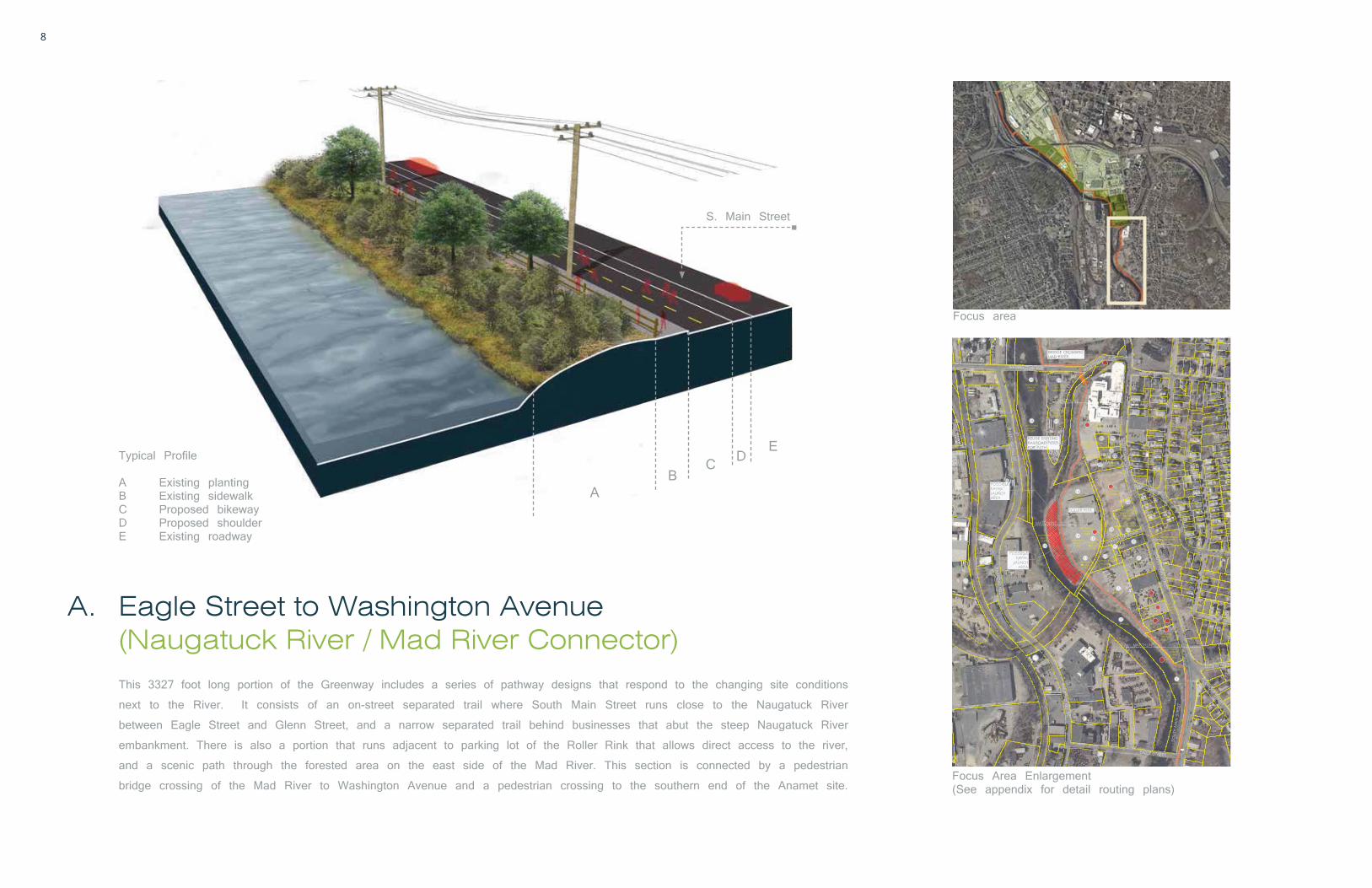
Focus area
Focus Area Enlargement (See appendix for detail routing plans)
This 3327 foot long portion of the Greenway includes a series of pathway designs that respond to the changing site conditions
next to the River. It consists of an on-street separated trail where South Main Street runs close to the Naugatuck River
between Eagle Street and Glenn Street, and a narrow separated trail behind businesses that abut the steep Naugatuck River
embankment. There is also a portion that runs adjacent to parking lot of the Roller Rink that allows direct access to the river,
and a scenic path through the forested area on the east side of the Mad River. This section is connected by a pedestrian
bridge crossing of the Mad River to Washington Avenue and a pedestrian crossing to the southern end of the Anamet site.
(Naugatuck River / Mad River Connector)A. Eagle Street to Washington Avenue
Typical Profile
A Existing plantingB Existing sidewalkC Proposed bikewayD Proposed shoulderE Existing roadway
cal Profile
Existing plantingExisting sidewalkProposed bikeway
A
S. Main Street
BDC
E

9
Proposed shared use trail along Naugatuck River / Mad RiverExample of pedestrian bridge over the Mad River
Typical condition of narrow spaces that abut the steep river embankment

10
B. Washington Avenue to Jackson Street
ATypical Profile
A Existing retaining wallB Pedestrian trail and seating areaC 5ft Amenity stripD 12ft BikewayE 5ft Amenity stripF Space for community events
B CEDF
This 2000 foot section of Greenway consists mainly of a wide tree lined riverfront esplanade. This allows for a leisurely walk
for pedestrians along the river’s edge with uninterrupted views of the river and sites beyond, while cyclists can ride unhindered
in the bicycle lanes, stopping as necessary to take in the view or visit facilities in the proposed redeveloped Anamet site.
The flat riverbank area behind the proposed parking lot on West Liberty Street offers an opportunity for public access to the
river and kayak launch. As the Greenway approaches West Liberty Street, it continues on the south side of the street as an
on street bike path then connects to Jackson Street as a separated trail on West Liberty and Bank Street where it connects
with, and traverses, the proposed Waterbury Greenway Riverfront Park.
Focus area
Focus Area Enlargement (See appendix for detail routing plans)
Existing conditions at the Anamet site
(Anamet Connector Project)

11
Proposed Esplanade at the Anamet Site

12
A
Typical Riverfront Trail Profile
A Naugatuck RiverB Riverfront Steps / Kayak LaunchC Multi-use pathD Park area
Proposed kayak launch
B
D
C
An approximately 19 acre riverfront Park with both active and passive park facilities will be constructed to revitalize an abandoned and disused
waterfront area within ½ mile of Downtown Waterbury. This Park will enhance the quality of life and livability of the Downtown area by providing
both residents and workers convenient access to large green open spaces and the Naugatuck River. It will also benefit the wider community by
providing much needed sports and active recreational facilities such as soccer fields, little league field, basketball, children’s playgrounds, kayak launch
as well as vegetated picnic areas. The proposed large lawn area for soccer could also be utilized for major public events where the slope of the
grade up to Interstate 84 abutments would act as a raised terrace and viewing area to activities on the lawns below. Parking would be available
under I-84 as well as along a reconstructed Jackson Street. The allure of such an iconic Park would ensure its long term success due to the many
different constituents attracted to the wide variety of amenities which in turn would act as a catalyst to economic development in the surrounding area.
To help facilitate both pedestrian and vehicle circulation in and around the site, Jackson Street which presently terminates at I-84, would be extended
through to Freight Street to provide a two way connection from areas both North and South of the park. Bicyclists and pedestrians could also utilize
the Greenway trail that would run along the top of the river embankment on the west side of the park, and a spur on the east side that would
connect the park with the train station and town center.
(Waterbury Greenway Riverfront Park)C. Jackson Street to Freight Street
Focus area
Focus Area Enlargement (See appendix for detail routing plans)

13
Existing conditions at Yankee Gas lands adjacent to Jackson Street
I-84River Jackson Street
Terraced
seating
Children’s P
layground
Improved
road s
afety
Connect with
the R
iver
The Great Lawn
Recreational Opportun
ity
Visually & Phy
sically
Multipurpose sp
ace for
community ga
thering
Kayak
launch an
d
grand
steps
seating
Working w
ith Existing
Topography
Safe p
lay area
for
children to b
e active
Safe P
edestrian
and
Vehicular
Access
Axonometric view of the proposed park

14
This section consists of the Waterbury Naugatuck River Greenway Trail from the northern limit of the Park to West Main Street
and the Freight Street Connector to Downtown Waterbury. The river portion of the Greenway is characterized by a restricted ROW
corridor as it crosses private property along the east side of the river to Freight Street, then crossing the Freight Street bridge
to continue along the east side of Riverside Street (adjacent to the west bank of the river). The Freight Street complete streets
reconstruction provides an opportunity to connect the river and the Greenway to the town center. The south side of the street
consists of a tree lined two way separated bicycle path and sidewalk with a large 11’-0” bio-swale buffer that accepts surface
runoff from the street and separates vehicles and cyclists. The north side of the street is characterized by a vegetated sidewalk
apron with street trees and a parking lane.
(Freight Street Connector Project)D. Freight Street to West Main Street
A
Typical Streetscape Profile
A Proposed concrete sidewalkB 4ft Amenity stripC 10ft BikewayD 11ft Stormwater planterE RoadwayF Curb with scuppersG Gravel inlet and trench
BC
E
FG
D
Focus area
Focus Area Enlargement (See appendix for detail routing plans)
Existing conditions at Freight Street
Lack of sidewalk

15
Freight Street Complete Street Downtown Connector(With proposed stormwater planter and bikeway)

16
Lack o
f Sidewalk
Water
Pooling
Utility
Conflict
Lack o
f sidewalks
discourages
people
from walking regularly
Standing
water
caused by
improper drainage
Utility lines
run along
the north side of
Freight Street
On Jackson Street extension approaching Freight StreetExisting conditions on Freight Street
Excessive Wide RoadOvercapacity
Sidewalk
Amenity Strip
Bikeway
Roadway
Street Parking
Approaching Meadow Street
On Freight Street

17
Proposed Freight Street Complete Street Connector

18
E. Jackson Street Extension north of Freight StreetJackson Street would extend north of Freight Street through this large self-contained block of commercial and industrial buildings creating a direct link to West Main Street. Crane Street would also extend down
to connect with the Jackson Street extension allowing further access to other parts of this large block. This new street grid will create smaller developable parcels and improve accessibility and traffic circulation.
The addition of these streets to the road network is expected to help catalyze development of the area and occur at the same time as this area is to be rezoned for higher density mixed use development. This
rezoning, along with the development of the nearby riverfront park, and proximity to the train station and the downtown, make this an ideal location for transit-oriented development.
Connecticut Light
& Pow
er Company
MRT Realty
Hayden Timothy (50%
)
and Amy (50%)
Environmental W
aste
Removal Inc.
Daddario
Enterprises Inc.
Elevated
train tracks
Freight Street
W. Main Street
Anaconda
American
Brass Co.
Existing conditions at Freight Street
Existing conditions at the Connecticut Light & Power Co.
Existing conditions at West Main Street
Pre-development Infrastructure Investment Opportunity
Create ‘right-sized’ development parcels

19
This connection is designed to create a direct unimpeded link between downtown and the proposed riverfront
Park and Greenway. It would require the construction of a new signature footbridge from the top of Library
Park over Meadow Street and then ramp down to the railway ROW. The trail would then cross at an at-
grade crossing of the active commuter rail line and continue on to intersect with a new multi-use path that
runs between the train station and park. This multi–use trail would be constructed on abandoned rail tracks
and run on the west side of the active rail lines and be separated from it by a fence, green space and
trees. It will also connect directly with the revitalized train station by way of an at-grade pedestrian crossing
of the active tracks.
F. Library Park & Train Station Connector
Proposed Library Park and Train Station Connector Trail
Proposed shared use trail
Pedestrian Crossing
Rail Trail
Pedestrian Bridge
Pedestrian Crossing
Meadow St.
Grand St.
LibraryPark
I-84
NaugatuckRiverfrontPark
Jackson Street
Existing conditions at Meadow Street (View north)

40
Waterbury Naugatuck River Greenway Phase 1 ExtensionFrom Eagle Street to West Main Street
Produced by the RBA Group 2013


![email brochure final[1]](https://img.pdfslide.us/doc/110x75/58795e8a1a28ab1e388b5d19/email-brochure-final1.jpg)