Embed Size (px)
Citation preview

2·53008
2012 Work Assessment Report
Prepared By:
Ed Shynkorenko (Lie. M-25405)
September, 2012
Claim
L-4269506
Tudhope Township Larder Lake Mining Division
N.T.S. Map 41 PINE
RECENED OCT 'L 1011
GEOSCIENCE ASSESSMENT
OFFICE ....J L
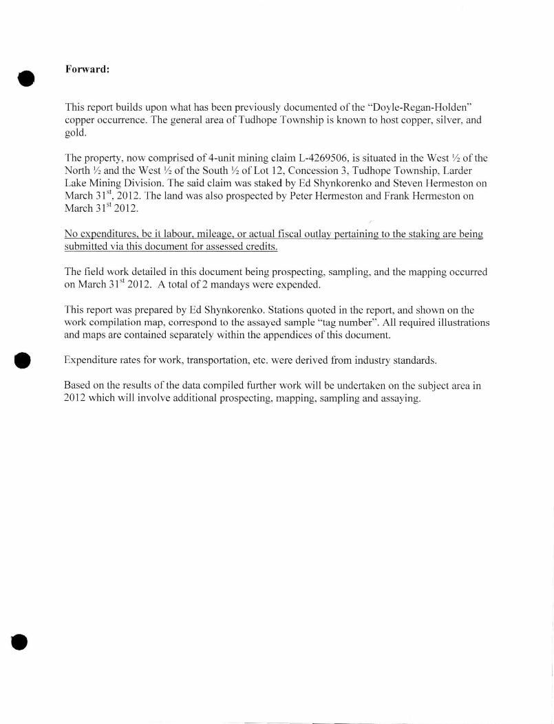
Forward:
This report builds upon what has been previously documented of the "Doyle-Regan-Holden" copper occurrence. The general area ofTudhope Township is known to host copper, silver, and gold.
The property, now comprised of 4-unit mining claim L-4269506, is situated in the West Y2 of the North Y2 and the West Yz ofthe South Yz of Lot 12, Concession 3, Tudhope Township, Larder Lake Mining Division. The said claim was staked by Ed Shynkorenko and Steven Hermeston on March 31 51
, 2012. The land was also prospected by Peter Hermeston and Frank Hermeston on March 31 51 2012.
No expenditures, be it labour, mileage, or actual fiscal outlay pertaining to the staking are being submitted via this document for assessed credits.
The field work detailed in this document being prospecting, sampling, and the mapping occurred on March 31 51 2012. A total of 2 man days were expended.
This report was prepared by Ed Shynkorenko. Stations quoted in the report, and shown on the work compilation map, correspond to the assayed sample "tag number" . All required illustrations and maps are contained separately within the appendices of this document.
Expenditure rates for work, transp011ation, etc. were derived from industry standards.
Based on the results of the data compiled further work will be undertaken on the subject area in 2012 which will involve additional prospecting, mapping, sampling and assaying.

Table of Contents
Introduction/History:
List of Illustrations:
Location:
Access:
Regional Geology:
Work Program:
Daily Log:
Conclusion:
Recommendations:
Author's Qualifications:
Communications (Direct/Indirect):
References:
List of Appendices
"Location Map"
"Claim Map & Abstract"
"Access Map/Key Map"
"Regional Geology Map"
Page (i)
Page (i)
Page (i)
Page (i)
Page (i)
Page (ii)
Page (iii)
Page (iii)
Page (iii)
Page (iii)
Page (iii)
Page (iv)
Appendix A
Appendix B
Appendix C
Appendix D
Appendix E
Appendix F
Appendix G
"Assessment Work Performed Before Recording Claims(s)" Form
"Work Compilation Map"
"Assay Results & Receipts"

Introduction/History:
The subject property has been known to host copper since the early years of the 20111 century. It is partially bordered along its eastern edge by the former "Holden Mine". Both properties, like numerous others in the immediate locale, were part of the historic Elk Lake-Gowganda silver camp. The mid portion of the subject property was formerly under mining lease which extended into the era of the "Temagami Land Caution". The area now contained within the boundaries of the subject claim had been previously staked and worked, off and on, for ten decades, and was acquired via staking by Steve Hermeston and Ed Shynkorenko in the spring of 2012.
An online search of pertinent files on record at the Resident Geologist Office in Kirkland Lake has File MDI41P09 W00047 listing this property as a copper (bornite-chalcopyrite) deposit with the moniker of "Doyle-Regan-Holden".
List of Illustrations:
All required maps and sketches referred to in this document are contained within the attached appendices.
Location:
The subject property and work areas are located within the West Yz of the North Y:z and the West Y:z of the South Y:z of Lot 12, Concession 3, Tudhope Township, Larder Lake Mining Division, being approximately 5.5 kilometres southeast of the community of Elk Lake, Ontario. (See Appendix A "Location Map " and Appendix B "Claim Map&, Abstract").
Access:
Access to within the southern portion the property is gained by utilizing 270 metres of an A TV trail which commences eastward from Highway 65 at approximately 5.5 kilometres southeast of Elk Lake. (See Appendix C ·'Access Map/Key Map "). As the trail crosses private lands permission from the land owner is to be obtained.
Regional Geology:
Generally, the area is located along the southern limits of the Abitibi Greenstone Belt where thick ipissing Diabase sills appear to intrude Precambrian metavolcanics and Middle Precambrian sediments. Distinct jointing of the diabase was noted at several locations on the property. From field observatiOJ!.S, approximately 15% of the property is exposed rock. A thick mat of moss covers most outcrops. (See Appendix D "Regional Geology Map '') .
(i)

Localized topography conditions are commonly shared amongst the outcrops. Elevations on the property range from 300 metres to 330 metres above sea level. The said exposed outcrops that protrude through the glacial till are for the most part steeply sloped. On average soils consist of an organic " A" horizon covering a modestly deep overburden of boulder-gravel, clay, and in some places bronze coloured sand.
"Typical outcrop 011 property"
The subject area is situated within a traditional Boreal Forest and Great Lakes St. Lawrence Forest transitional zone setting. Forest cover includes cedar, black spruce, black ash, and tamarack in the lower, wetter areas changing to a white spruce, white pine, jack pine, red pine, balsam fir, white birch, and red maple over the more elevated areas of the property. The propetiy is drained by a southward trending creek and several smaller draws.
Work Program:
(Rationale)
The purpose of the activities reported in this document was to augment the knowledge base of the property by physically locating and sampling previously dug trenches and pits with the overall objective of locating intact veins located within the boundaries of the propetiy. A commercially viable deposit of copper is the main objective pursued (See Appendix E ''Assessment Work Performed Before Recording Claims(s) "form.
(ii)

Daily Log:
March 31st 2012
The work area subsequently recorded as Claim L-4269506 was prospected by Peter Hermeston and Frank Hermeston; 6.5 kilometers in total were traversed. A long segment of historical trenching was located along the western edge of property trending northward. However, the soil was still frozen and the trench was filled with the residual snow-ice of winter making it not possible to collect samples at the time. Portions of the northern slopes of the higher outcrops were also still banked with ice and snow, including the area of the reported centrally located shaft-pit. Numerous exposed outcrops containing a dark diabase were located. One rock sample and one soil sample were taken-assayed (See Appendix F "Work Compilation Map " and Appendix G "Assay Results & Receipts ") .
Conclusions:
Approximately 100 metres of historical trenching has been confirmed on the property. The one rock and one soil sample analyzed thus far has not produced an indication of commercial mineralization.
Recommendations:
Given that several areas of interest, including the area of the reported pit-shaft, was still partially snow covered on March 31 51 2012, it is recommended that further prospecting, sampling, and assaying should be undertaken later in the summer. A Beep Mat should be utilized along the lengths of located existing trenches and possible vein extensions thereof.
Author Qualifications:
The author is an honour graduate of the Sault College of Applied Arts and Technology forestry program ( 1980, Sault Ste. Marie, Ontario), and is a long time employee with the Ministry of Natural Resources. Throughout the past 30 years he has been exposed to numerous mining projects (Hemlo, Detour Lake, and Agrium). As a private individual he has staked and transferred numerous mining claims since 1983. He has staked, and successfully optioned claims situated in Steele Township, Larder Lake Division. An avid reader of accredited material , the author is in the process of expanding his knowledge base in order to augment his prospecting efforts. Prospecting remains his life-long hobby.
Communications (Direct & Indirect):
Peter Hermeston, fellow prospector, North Bay, Ontario. Frank Hermeston, fellow prospector, North Bay, Ontario. Steven Hermeston, fellow prospector, North Bay Ontario
(iii)

References:
OGS Report 5439 "Industrial Minerals ofNorthern Ontario-Supplement 2" (Vos and Smith) 1983
MND&M File MDI41P09NW00047
MND&M File 2.2783 (KL Resident Geologist Office) "Report on Geophysical Surveys, Claims 496559 and 496560, 1 orthern Silver Fox Resources, Tudhope Township, Ontario (Willars 1978)
(iv)
--- ____ _ _ _______ _____j

APPENDICES

Appendix "A"

~ ___: I
'-"'1• J
UTI.I 7.DI'1ft t 7 1001)-lgi'IO
r--rr-:-~~ ~ l'l I~ I "'
S53<lOO£
General Information and Linilabons
ONT/IRIO CANA.DA
Mining Land Tenure Map
Date 1 Time of Issue: Wed Aug 0115:39:22 EDT 2012
TOWNSHIP I AREA
TUDHOPE
PLAN
G-3724
ADMINISTRATIVE DISTRICTS I DIVISIONS
Mining Division Land Titles/RegisiJy Division
Larder Lake TIMISKAMING KIRKLAND LAKE Ministry ol Natural Resources District
TOPOGRAPHIC LBld Tenure
u [l
0 ID
El ----
LAND TENURE WITHDRAWALS
G :::-:::.::·~ w.~ --·---·-· -·--:.r•::C..<d - · .. ,_ ....... ---... --...... --~-..... ~ _u...,·•-......_ n IMPORT ANT NOTICES
LAND TENURE WITHDRAWAL DESCRIPTIONS
"'I ll t •'ol ,_ 'UJ<I . !WI
.ol:ffEJ S..rJI<U.-1111<f-'llilll'fl'lUIDIIIU._Lit:U I 'iM'<a >'f«: o -..•ouon•o~t >t'< -""' "- "'.,-,_.,_.,~__..,..,.._.,.,., .. ,,.,~u """'u ~,...._ ... ,_ ... ___ ,_,._ .. . .q~ .. --·~.._ .. c:a-....... , _ _.,..,_-.. , ... '""~·~-·· ..... ...,_ --··-~· .... -..• -............ . __ ,..,..on:.toouor-.. t---•- Co<h_,.
St-tt3S t!'OI
Gl.AI'1
v

• • Mining Lands - Mining Divisions of Ontario
f~> ~r. Ontario
• Home • Mines and Minerals • Not1hem Development • News • Site Map • Contact Us
Mining Claim Abstract I Main Menu I Back I
LARDER LAKE - Division 80
Ministry of N orthem Developn1ent and Mines
Claim No: L 4269506
Page 1 of2
Status: ACTIVE
Due Date: 2014-Apr-02 Recorded: 2012-Apr-02
Work Required: $ 1,600 Staked: 2012-Mar-31 16:35
Total Work: $0 Township/A rea: TUDHOPE (G-3724)
Total Reserve: $ 0 Lot Description: Wl/2 ofN1/2+Wl/2 ofSl/2 L12, C3
Present Work $0 Claim Units: 4
Assignment:
Claim Bank: $0
C laim Holders H.ecorded Holder(s) Per(.·entage SHYNKORENKO, EDWARD ( 40.00 %) HERMESTON, PETER M ( 40.00 %) HERMESTON, FRANKLIN DOUGLAS ( 10.00 %) HERMESTON, STEVEN ANGUS ( 10.00 %)
Transaction Listing T)'pc Date Applied STAKER20 12-Apr-02
TRAN 2012-Jun-04
TRAN 20 12-Jun-06
TRAN 2012-Jun-06
Claim Reservations
[)cscription RECORDED BY SHYNKORENKO, EDWARD (M25405) SHYNKORENKO, EDWARD (194158) TRANSFERS 10.00% TO HERMESTON, STEVEN ANGUS (409466) SHYNKORENKO, EDWARD (194158) TRANSFERS I 0.00 % TO HERMESTON, FRANKUN DOUGLAS (409465) SHYNKORENKO, EDWARD (194158) TRANSFERS 40 .00 % TO HERMESTON , PETER M (403428)
01 400' surface rights reservation around all lakes and rivers
Client Number 194158 403428 409465 409466
Performed Numhcr Rl 280.01153
T 1280.00283
Tl280.00284
T 1280.00285
http: //www.mci.rnndm.gov.on.ca/Ciaims/Cf_Ciaims/clm_cssm.CFM?Claim_ View_ Clai... 01/08/2012

Mining Lands - Mining Divisions of Ontario
02 Sand and gravel reserved 03 Peat reserved 04 Other reservations under the Mining Act may apply 05 Including land under water 06 Excluding road
• Home • Mines and Minerals • Northern Development • News • Site Map • Contact Us
X This site is maintained by the Government of Ontario, Canada
• Accessibilitv • Privacy • fmportant Notices
Copyright information: © Queen's Printer for Ontario. 1008
Page 2 of2
http://www.mci.mndm.gov.on.ca/Ciaims/Cf_ Claims/elm_ cssm.CFM?Ciaim _ View_Clai... 01 /08/2012

UTM Zone 17 5000m grid
LOT 7, CON2
LOT 7. CON .. 1
LOT S. CON 3
LOT 12, CON 11 ~ .. ~ R
~" r, r•
tqT 1,CON 3
LOT, 10, CON 4
TUQI'IOPE 1 .• ; ;
··"·
LOT IO,CO.N 3 . ~~}
,,_ .,, LOT 9,CON 3
"<1? · ·:f. '
~269089 . '{...o

APPENDIXD
GENERAL-REGIONAL GEOLOGY
- -------
Leg earl
Phanerozoic (Borderlan~ Rocks
\' ···' 'J Sedimentar.t rocks
Prou.rozoic {Southern Province}) Rocks
- Alkaline intrusive rocks
U Gneisses and migmatites
- Sudbury intrusive Complex
~ V'/hilewater Group Seciiments
l'&~ Mafic intrusr...e (diai>ase) dikes and silis
Keewe~ mafic ,,.Gicanic and associated sedimentary rocks
Cobalt Group sedimen!arf rocks
ltM Uftramailc to mafic intrusi-.-e rocks
Archean (Superior Pravince} Rocks ---Sedimentary rocks. some highly mmamll'flhosed
lntenneriiste 1ll falsie volcanic rocks
Mafic to intermediate volcanit: rocks
l \ Felsic il'.trusi>le rocks ar:d gr.eisses

, f):., ·'-:? v- Ontario Ministry of
Northern Development and Mines
Assessment Work Performed Before Recording Claim(s)
Mining Act, Subsections 65(2) and 66(2), R.S.O. 1990
Folder Identification Number (office use)
Transaction Number (office use)
W -
Submission Number (office use)
2.
Personal information collected on this form is obtained under the authority of subsections 65(2) and 66(2) of the Mining Act. Under section 7 of the Mining Act, this information is used to maintain a public record. This information will be also used to review the assessment work and correspond with the mining land holder. Questions about this collection should be directed to the Senior Manager, Mining Lands Section, Ministry of Northern Development and Mines, 3'• Floor, 933 Ramsey Lake Road, Sudbury ON P3E 685. Telephone 1 888 415-9845.
Instructions: - Only use this form for regional surveys and prospecting performed on Crown land and Crown mining rights that are open for staking before a mining claim is recorded as a result of the work performed.
- For work performed on recorded claims or other mining lands, use the form Assessment Work Performed on Mining Lands.
- Please type or print in ink. - Submit to Geoscience Assessment Office, 933 Ramsey Lake Road,
Sudbury ON P3E 685. Telephone 1 888 415-9845.
Note: All correspondence will be sent to the address on record in the Provincial Recording Office, as required under the Mining Act, subsections 19(6) and (8).
1. Submitter I am D an authorized agent or IZl the recorded holder (if a company, enter name of person submitting) Last Name I First Name 'Initial I Client number (optional) Shynkorenko Edward 194158
Address- Unit number, Street number, Street name
P.O. Box 1715 City, Town or Village I Province or State Country I Postal Code Cochrane Ontario Canada POL !CO Telephone number I Fax number E-mail address (optional)
(705) 272-3998 (705) 272-8545 [email protected]
2. Provide
Ill your technical report and maps in paper or on a compact disc D a current legible map showing how the contiguous mining lands are linked for assigning work 121 proof of beneficial interest
3. Type of Work Performed - please check off the type of survey performed (optional)
Work Type Survey Type Work Type Survey Type
Airborne 0AEM Prospecting !Jiii"Prospecting geophysical 0AMAG
0AVLF
0 other airborne geophysical
Regional or Please specify the type reconnaissance ground exploration
Continued on nex1 page
0240E (2011/11 ) C Queen's Printer for Ontario, 201 1

4. Dates and Costs of Work Performed -This includes the date you traveled to the field or mobilized equipment to the date the technical report was completed .
From: DD/MMMMIYYYY (enter the month in full in this box e.g. 12/July/2008) To: DD/MMMMIYYYY (enter the month in full in this box e.g. 28/July/2008) 3 1/03/20 12 2 1/09/20 12
Reg ulations - Regional surveys and prospecting performed on Crown land and m ining rights open for staking are elig ible for credit only if : 1. a mining claim is subsequently staked and recorded , and 2. work is performed no earlier than 1 year before the recording date of the mining claim , and 3. work performed is filed within 1 year following the record ing date of the mining claim.
4(A) Work Costs
From date To date Work Type Unit of Work Cost per Unit of Actual Costs DD/MMIYYYY DD/MMIYYYY (example: hours/day, Work ($)
metres of drilling, km of grid lines)
31 /03/20 12 31 /03/2012 prospecting 2 man days 240.00 480
01/09/2012 21 /09/20 12 report prep. 4.5 mdys accrued 240.00 1,080
4(8) Associated Costs
From date To date Type of Associated Costs Actual Costs DD/MMIYYYY DD/MMIYYYY (example: supplies, mobilization, demobilization) ($)
03/08/20 12 03/08/20 12 mail out of samples to to lab. 10
03/08/2012 12/09/2012 assays from mail out to results rec'd 69
3 1/03/20 12 31 /03/2012 field supplies: sample bags, tape, batteries, etc. 10
4(C) Transportation Costs
From date To date Type of Transportation Costs Actual Costs DD/MMIYYYY DD/MMIYYYY ($)
31/03/2012 31 /03/2012 travel !Tom North Bay to property and rtn. , 450 kms @ $0.40 per km. 180
4(0) Food and Lodging Costs
From date To date Type of Food and Lodging Costs Actual Costs DD/MMIYYYY DD/MMIYYYY ($)
3 1/03/2012 31 /03/2012 bush lunches and water for two men 20
Total of Actual Costs (4A through 40) 1,849 1
Enter 100% of the total amount of assessment work credits being declared for work performed ON the mining claims recorded
after regional survey or prospecting = l ,849.00 ($X) .
Enter portion of Assessment Work Credits being declared for total work performed on adjacent Crown land not subsequently
staked and recorded 0.00 ($Y) multiply by 0.25 = ($Z).
See Assessment Work Regulation subsection 8(2). The $X and $Z totals should match column totals in table #5.
0240E (2011/11) © Queen's Printer for Ontario, 2011

5. Credits to be Recorded and Applied, Assigned, Banked
Mining Claim Number Number of Amount of Work Performed Amount of Amount of Bank Claim Before Staking and Recording Credits Applied Credits (Amount of Units this Claim to this Claim ($) Assigned to credits to be
100% of costs 25% of costs Other Mining applied or
for work on for work on Claims($) assigned at a
area now a adjacent future date)
mining claim Crown land
L-4269506 4 1,849.00 1,600.00 249.00
Column Totals $X $Z
1,849 0 1,600 0 249
Note: Work performed on mmmg claims ($X + $Z) cred1ts applied + cred1ts banked
0 Schedule attached (if you have more entries attach a schedule)
6. Some of the credits claimed in this Assessment Work form may be reduced. Please indicate below how you want your credits reduced if they are not approved. Check(~) in the boxes below. If you have not indicated how your remaining credits are to be allocated, credits will be reduced from the Bank first, followed by option number 2 if necessary. Credits are to be cutback:
Ill 1. Credits are to be cut back from the Bank first, followed by option 2 or 3 or 4 as indicated; or
D 2. Credits are to be cut back starting with the claims listed last, working backwards; or
D 3. Credits are to be cut back equally over all claims listed in this Assessment Work form; or
0 4. Credits are to be cut back as shown below:
List the claim numbers in the order you want the credits to be cut back (setting your priority list) .
Priority Claim Number Priority Claim Number
1. 4269506 6.
2. 7.
3. 8.
4. 9.
5. 10.
0 Schedule attached (if you have more entries attach a schedule)
7. Commodities Explored for please list (optional)
cu, ag, au
8. Certification by Recorded Holder or Authorized Agent
I, ~~ , do hereby certify on (Signature)
---c:=-=2-=-
1c-:10
-::-:9:-::12
-::-:0:-1_2 ___ that I have personal
(DD/MMIYYYY)
knowledge of the facts set forth in this Assessment Work form having caused the work to be performed or witnessed the same during or after its completion and, to the best of my knowledge, the annexed report is true.
0240E (2011111 ) © Queen's Printer for Ontario, 2011

I
\
Pat. Land
Pat. Land
-
, 554379E 5284385N
"Remnants of old fence••
Pat. Land ,
< 270 metres+/- to Hwy. 65
----- ~- --
Pat. Land
~-./"
. ..
I ··t- --- TUD-01-12
1
\
1 (Mar.31/\~)
L.P.
L.P.
, L.P. i
1 r p.
p.\ ~ " " ... "" ~ 0
" "" t)~ -'J
I I
I
I 554379E 5282825N
L-4269506 West 1,12 of the North 1/2 & West Yl of the South 112 of Lot 12,
Concession 3, Tudhopc Township,
I TUfJ-02-12 •tQfd cut-over"
/
- --- .... _ --
I I
/ -- - -- --
. /\ ...
Tag Number
TUD-01-12
TUD-02-12
I
I
. '
I
J I
I
I
' '
I
I
Sample Type
Rock
Soil
554779E 5284385N
\
I ..
- L.P.
I
I I
. !
j '
I ' •
~'I . I . fL.P.
\
APPENDIX "F"
"Work Compilation Map"
Claim L-4269506
Tudhope Township Larder Lake, Mining Division
Scale 1:3150 ·
NAD83
Pat. Land
"Remnants of abandoned hunt camp"
I
· 554779E 5282825N
. Pat. Land
GPSin NAD 83
0554770E x 5284380 N
0554557E X 5283817 N
LEGEND
Claim Post & Line • Line/Date-. of Traverse ><Mar. 31/12>
Line Post L.P .
Outcrop with Jointing .-. Sample Location )\ Trench k:' <D
Access Tniil/Road - - - , - - -Swamp x .:r .::.IC
Creek ~ ... ~ · ·· r-
Prepared By:
Ed Shynkorenko, Sept. 2012
. ''li
· ·.~
• ' ·:.