Embed Size (px)
Citation preview
www.sonomacountywater.org/svgroundwater
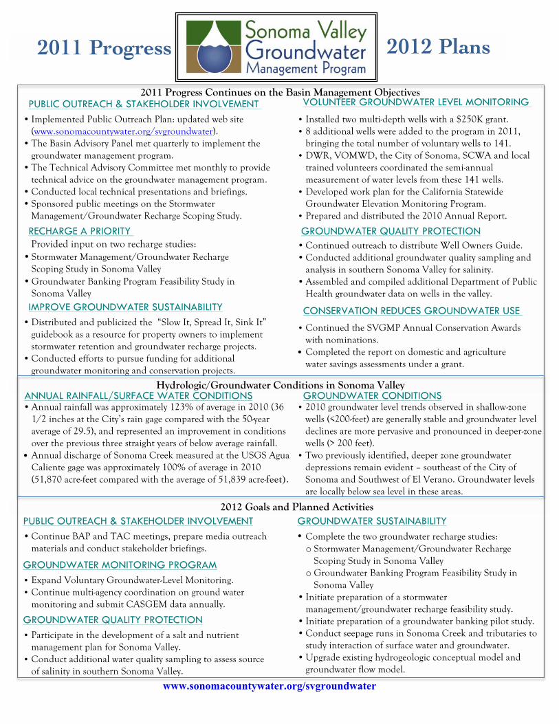
2011 Progress
2012 Plans
• Implemented Public Outreach Plan: updated web site (www.sonomacountywater.org/svgroundwater).
• The Basin Advisory Panel met quarterly to implement the groundwater management program.
• The Technical Advisory Committee met monthly to provide technical advice on the groundwater management program.
• Conducted local technical presentations and briefings. • Sponsored public meetings on the Stormwater
Management/Groundwater Recharge Scoping Study.
VOLUNTEER GROUNDWATER LEVEL MONITORING PUBLIC OUTREACH & STAKEHOLDER INVOLVEMENT • Installed two multi-depth wells with a $250K grant. • 8 additional wells were added to the program in 2011,
bringing the total number of voluntary wells to 141. • DWR, VOMWD, the City of Sonoma, SCWA and local
trained volunteers coordinated the semi-annual measurement of water levels from these 141 wells.
• Developed work plan for the California Statewide Groundwater Elevation Monitoring Program.
• Prepared and distributed the 2010 Annual Report.
GROUNDWATER QUALITY PROTECTION
• Distributed and publicized the “Slow It, Spread It, Sink It” guidebook as a resource for property owners to implement stormwater retention and groundwater recharge projects.
• Conducted efforts to pursue funding for additional groundwater monitoring and conservation projects.
RECHARGE A PRIORITY Provided input on two recharge studies: • Stormwater Management/Groundwater Recharge
Scoping Study in Sonoma Valley • Groundwater Banking Program Feasibility Study in
Sonoma Valley IMPROVE GROUNDWATER SUSTAINABILITY CONSERVATION REDUCES GROUNDWATER USE
• Continued the SVGMP Annual Conservation Awards with nominations.
• Completed the report on domestic and agriculture water savings assessments under a grant.
• Continued outreach to distribute Well Owners Guide. • Conducted additional groundwater quality sampling and
analysis in southern Sonoma Valley for salinity. • Assembled and compiled additional Department of Public
Health groundwater data on wells in the valley.
ANNUAL RAINFALL/SURFACE WATER CONDITIONS
PUBLIC OUTREACH & STAKEHOLDER INVOLVEMENT
2011 Progress Continues on the Basin Management Objectives
• Participate in the development of a salt and nutrient management plan for Sonoma Valley.
• Conduct additional water quality sampling to assess source of salinity in southern Sonoma Valley.
GROUNDWATER CONDITIONS
GROUNDWATER MONITORING PROGRAM
GROUNDWATER QUALITY PROTECTION
• Complete the two groundwater recharge studies: o Stormwater Management/Groundwater Recharge
Scoping Study in Sonoma Valley o Groundwater Banking Program Feasibility Study in
Sonoma Valley • Initiate preparation of a stormwater
management/groundwater recharge feasibility study. • Initiate preparation of a groundwater banking pilot study. • Conduct seepage runs in Sonoma Creek and tributaries to
study interaction of surface water and groundwater. • Upgrade existing hydrogeologic conceptual model and
groundwater flow model.
GROUNDWATER SUSTAINABILITY • Continue BAP and TAC meetings, prepare media outreach
materials and conduct stakeholder briefings.
• Annual rainfall was approximately 123% of average in 2010 (36 1/2 inches at the City’s rain gage compared with the 50-year average of 29.5), and represented an improvement in conditions over the previous three straight years of below average rainfall.
• Annual discharge of Sonoma Creek measured at the USGS Agua Caliente gage was approximately 100% of average in 2010 (51,870 acre-feet compared with the average of 51,839 acre-feet).
• 2010 groundwater level trends observed in shallow-zone wells (<200-feet) are generally stable and groundwater level declines are more pervasive and pronounced in deeper-zone wells (> 200 feet).
• Two previously identified, deeper zone groundwater depressions remain evident – southeast of the City of Sonoma and Southwest of El Verano. Groundwater levels are locally below sea level in these areas.
• Expand Voluntary Groundwater-Level Monitoring. • Continue multi-agency coordination on ground water
monitoring and submit CASGEM data annually.
Hydrologic/Groundwater Conditions in Sonoma Valley
2012 Goals and Planned Activities
!.!.!.!.
!.!.
!.!.!.#0!.
!.!.
!.
#0!. !.!.!. !.
!.!.
!.
!.
#0
!.
!.!.
!.
#0
!.
!.!.
!. !.!. !.!.!. !.!.
!.
!.
!.
!.!.!.!. !.!.!. !. !.!. !. !. !.!.!. !.!.#0 #0#0#0 !.!. !.!.!. !.!. !.!.
!.!. !. !.!. !. !.!.!. !.!.!. !.!. !.!. !.!.!. !.!.#0 !.!.!. !. !.!.!.!. !.!. #0!.!.!.!. !.!.!. !.!.!. !.#0#0 !.!. !.!.!.!.#0
#0!. !.!. !.!. !.!.!. #0!.!.!. !.!.!. !.!.!. !.!. !.
#0 !.
!.
!. !.!.
!.!.
!.
!.!.!.
#0
#0!.
!.
!.
!.
!.
!.
!.!.
!.Q18-01
N16-01
M18-03
M18-02
M18-05
M18-04
M18-01
M17-02M17-01
O17-01N16-03
N16-02 O16-01
O15-01
H14-03 H14-02
H14-01
I13-01
P13-01
H13-01
H12-01
H12-02H12-03
N12-01L12-02
M12-01O12-01
M12-03
O12-02
N12-02
O11-02
N11-01
O11-01
O11-03L11-04
L11-02L11-03
L11-01
J10-01
K09-01
J08-04
H08-01
J08-02H08-02
J08-05 J08-03
J08-01 J07-02
J07-03I07-01
J07-01I06-02
G03-05
I05-01
H05-04
K09-02
I06-01
F06-01
F06-02
H06-02
G06-01
H06-01
H05-03
H05-02H05-01
G04-03H04-02
H04-04
H04-01
H04-03
G04-02G04-01
G03-04
G03-03G03-02
G03-01
N23-01
M23-01
L22-01
N16-04
M18-06
San Pablo Bay
Schell SloughRainbow Slough
Bush Slough
China Slough
Lake Suttonfield
Fern Lake
Hudeman Slough
Lake Josephine
Gravelly Lake
Lee Lake
Goose Lake
Wilson Creek
04
04
04
04
04
·|}þ37
·|}þ29
·|}þ128
·|}þ121
·|}þ116
·|}þ12
·|}þ29
tu101
²0 1 2 3 4 50.5
Miles
Figure2-1
A B C D E F G H I J K L M N O P Q R S T
2
3
4
5
6
7
8
9
10
11
12
13
14
15
16
17
18
19
20
21
22
23
24
25
August 31, 2011
#0
!.!. !.
!.!.#0#0!.!.!. !.
!.!.!. !.!. !. !.!.
!.!.!. !.!. !.!. !.!.
!. !.!.!.!.
!.!. !.!.!.!.
!.
!. !.!. !.!.!.
!.!.!. !.
!.
M
J13-04
K15-01K15-10 K15-09
K15-08K15-06
K15-05
K15-04K15-07 K15-03
K15-02
L14-01
K14-02 K14-06
K14-05 K14-04K14-01
K14-03
J13-01
J13-03
J13-02
K13-07
K13-08
K13-01L13-04K13-12
L13-02
K13-11
L13-03K13-04
K13-03
K13-02
K13-10
L13-01K13-05K13-09
K13-06
J12-04
K12-02L12-06
K12-01
J12-03
L12-05
L12-04
L12-03J12-02
J12-01
L12-01
L11-03
K11-01
L11-05
J12-05
!.!.
!.
!.
!. !.
!.!. !.!. !.!.!. #0!.!.!. !.!.!.!.!. !.
#0 !.!. !.
!.!.
!.!. #0
!.
!.
#0
!.!.
!.!.
M13-14
N13-07
M15-03
M15-04
M15-02
M15-01
N15-02
N15-01
M14-05M14-03
O14-02N14-02
N14-01
M14-02
O14-01
M14-01
N13-02M13-13M13-12 M13-11
M13-10
M13-09
M13-08
M13-07
M13-06
N13-01
L13-05
N13-05
N13-04
M13-02
M13-03
M13-01
N13-03
N13-06
M13-04
M13-05
N14-03
N16-05
N15-03
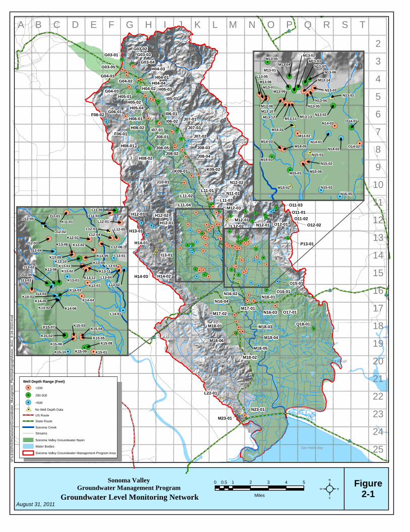
Sonoma Valley Groundwater Management Program
Groundwater Level Monitoring Network
\\F
ILE
SE
RV
ER
\Dat
a\w
rp\G
roun
dwat
er_
Man
agm
ent_
Pla
n\H
ydro
gra
phA
ssoc
_8x1
1_6
-24-
2010
.mxd
Well Depth Range (Feet)
!. <200
!. 200-500
!. >500
US Route
State Route
Sonoma Creek
Streams
Water Bodies
Sonoma Valley Groundwater Management Program Area
Sonoma Valley Groundwater Basin
#0 No Well Depth Data