Embed Size (px)
DESCRIPTION
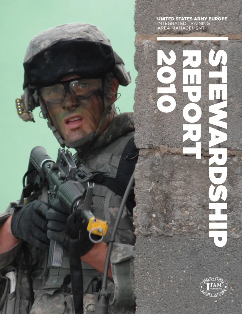
The 2010 USAREUR ITAM Stewardship Report, highlights the performance and accomplishments of program
Citation preview
STEW
ARDSHIP
REPORT
2010
UNITED STATES ARMY EUROPEINTEGRATED TRAININGAREA MANAGEMENT
2 65 Years of Training Land Mapping
4 Foreword
5 Measuring Success
6 Ready and Forward Deployed
8 ITAM 2010 – What and Where?
10 ITAM 2010 – Project Catalog
14 Hohenfels Off-Limits Area Management
16 Enhancing Training Realism
17 Land Reconfiguration Best Management Practices
20 Annual SRP Workshop
21 Grafenwoehr Training Area – Celebrates 100 Years
22 Sustainable Range Awareness Events
24 Geographic Information System
25 Products and Services – Army Range Mapper
26 Products and Services – Digital Media
26 Products and Services – Maps and Atlases
28 Products and Services – Other Products
29 2010 Notable Documents
30 Funding and Way Ahead
CONTENTS
GRAFENWOEHR
HOHENFELS
Aerial Imagery Satellite Imagery
% of forest cover
20%
1946 1947 1948 1949 1950 1953 1954 1955 1956 1957 1958 1959 1960 1961 1962 1964 1965 1966 1967 1968 1969 1970 1971 1972 1975 1976 1977 1978 1979 1980 1981 1982 1984 1985 1997 2000 20011945 1951 1963 1973 1974 19831952 1988 1998 2002 2003 2004 2005 20061989 1990 1991 1992 1993 1994 1995 1996 1999 2008 2009 201019871986 2007
1946 1947 1948 1949 1950 1953 1954 1955 1956 1957 1958 1959 1960 1961 1962 1964 1965 1966 1967 1968 1969 1970 1971 1972 1975 1976 1977 1978 1979 1980 1981 1982 1984 1985 1997 2000 20011945 1951 1963 1973 1974 19831952 1988 1998 2002 2003 2004 2005 20061989 1990 1991 1992 1993 1994 1995 1996 1999 2008 2009 201019871986 2007
40%
60%
80%
20%
40%
60%
80%
% of forest cover
RANGE 201 1945 BUNKER DZ 1952 PA 255 1973 RANGE 213 1973 RANGE 301 1983 GTA MAIN POST 2010
RANGE 201 2010
HOHENBURG RUIN 1945 STOL STRIP 1963 GTA MOUT SITE 1963 HOHENFELS DZ 1993 HOHENBURG DZ 2005
GTA MAIN POST 1945 GTA MAIN POST 2001
RANGE 307 1988CAMP ALBERTSHOF 1963
UEBUNGSDORF MOUT 1981
HOHENBURG RUIN 20101983 20101963
201019811963
1945
1945
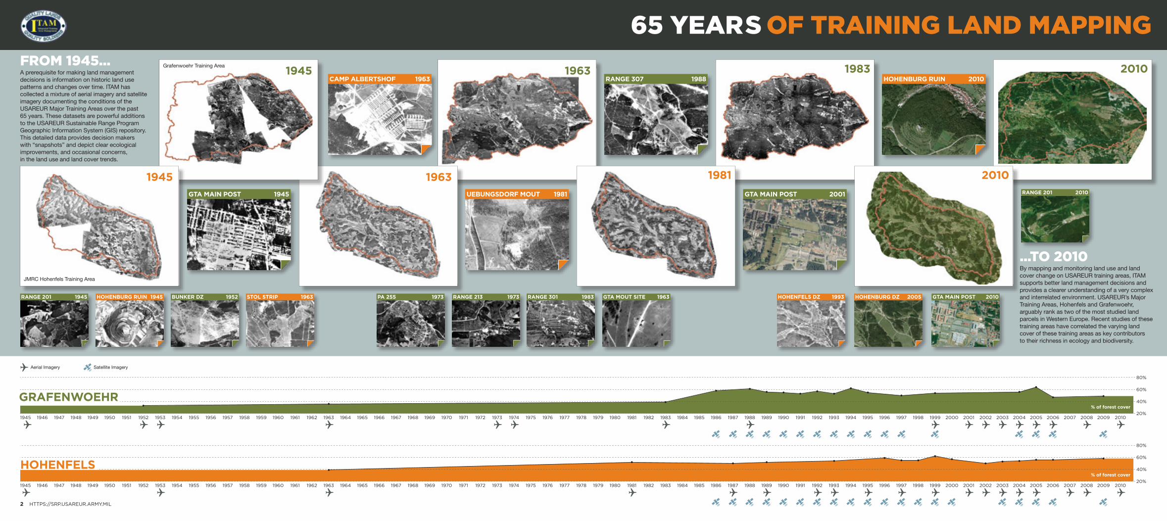
FROM 1945...A prerequisite for making land management decisions is information on historic land use patterns and changes over time. ITAM has collected a mixture of aerial imagery and satellite imagery documenting the conditions of the USAREUR Major Training Areas over the past 65 years. These datasets are powerful additions to the USAREUR Sustainable Range Program Geographic Information System (GIS) repository. This detailed data provides decision makers with “snapshots” and depict clear ecological improvements, and occasional concerns, in the land use and land cover trends.
...TO 2010By mapping and monitoring land use and land cover change on USAREUR training areas, ITAM supports better land management decisions and provides a clearer understanding of a very complex and interrelated environment. USAREUR’s Major Training Areas, Hohenfels and Grafenwoehr, arguably rank as two of the most studied land parcels in Western Europe. Recent studies of these training areas have correlated the varying land cover of these training areas as key contributors to their richness in ecology and biodiversity.
65 YEARS OF TRAINING LAND MAPPING
2 HTTPS://SRP.USAREUR.ARMY.MIL
Grafenwoehr Training Area
JMRC Hohenfels Training Area
5
STEWARDSHIP REPORT 2010
4 HTTPS://SRP.USAREUR.ARMY.MIL
2010 marked a banner year for the ITAM program, 25 years of supporting U.S. Army Europe (USAREUR). Since the Hohenfels Training Area was selected as one of the first ITAM pilot areas in 1985, the program has defined an era of military land management. ITAM has matured both spatially and functionally, growing from a Hohenfels centric erosion repair focus to a multifaceted program providing monitoring, mapping, training, land maintenance, and land reconfiguration to every U.S. Army training area in Europe. ITAM has pioneered best management practices and innovative technologies which are now recognized across the land management profession as standards for sound environmental sustainability.
As always, ITAM’s priorities will focus on sustaining the availability, accessibility, and capability of training areas. This is especially critical for USAREUR’s enduring training areas, which will support military units with higher home station dwell times and a corresponding intensification of training land use. Additionally, the land reconfiguration section of this report overviews future priorities of the Sustainable Range Program in addressing the realism factor between the operational environment and the training environment.
The complexities of coordinating land reconfiguration projects will emphasize ITAM’s reliance on partnerships. Partnerships with U.S. and external agencies, host nations, landowners, and NGOs are of paramount importance. None of the accomplishments cited in this report could have been achieved without the support of the Command and the dedication of our valued partners.
This report provides a snapshot of the program and more importantly attempts to address ITAM’s focus for the future. I hope you find our latest Stewardship Report constructive and we are always pleased to receive feedback.
Nathaniel WhelanUSAREUR ITAM Program Manager
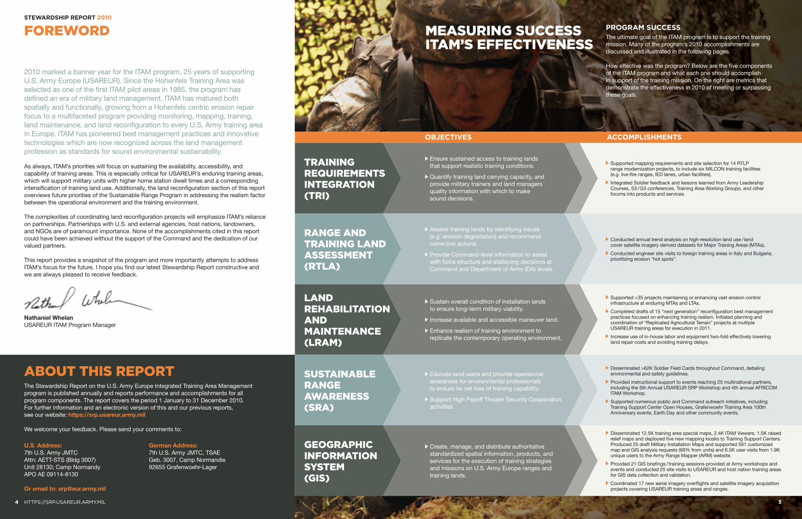
FOREWORD MEASURING SUCCESS ITAM’S EFFECTIVENESS
The Stewardship Report on the U.S. Army Europe Integrated Training Area Management program is published annually and reports performance and accomplishments for all program components. The report covers the period 1 January to 31 December 2010. For further information and an electronic version of this and our previous reports, see our website: https://srp.usareur.army.mil
We welcome your feedback. Please send your comments to:
ABOUT THIS REPORT
PROGRAM SUCCESSThe ultimate goal of the ITAM program is to support the training mission. Many of the program’s 2010 accomplishments are discussed and illustrated in the following pages.
How effective was the program? Below are the five components of the ITAM program and what each one should accomplish in support of the training mission. On the right are metrics that demonstrate the effectiveness in 2010 of meeting or surpassing these goals.
U.S. Address:7th U.S. Army JMTC Attn: AETT-STS (Bldg 3007) Unit 28130; Camp Normandy APO AE 09114-8130
Or email to: [email protected]
German Address:7th U.S. Army JMTC, TSAE Geb. 3007, Camp Normandie 92655 Grafenwoehr-Lager
TRAINING REQUIREMENTS INTEGRATION (TRI)
Ensure sustained access to training lands that support realistic training conditions.
Quantify training land carrying capacity, and provide military trainers and land managers quality information with which to make sound decisions.
Supported mapping requirements and site selection for 14 RTLP range modernization projects, to include six MILCON training facilities (e.g. live-fire ranges, IED lanes, urban facilities).
Integrated Soldier feedback and lessons learned from Army Leadership Courses, S3 / G3 conferences, Training Area Working Groups, and other forums into products and services.
LAND REHABILITATION AND MAINTENANCE (LRAM)
Sustain overall condition of installation lands to ensure long-term military viability.
Increase available and accessible maneuver land.
Enhance realism of training environment to replicate the contemporary operating environment.
Supported >35 projects maintaining or enhancing vast erosion control infrastructure at enduring MTAs and LTAs.
Completed drafts of 15 “next generation” reconfiguration best management practices focused on enhancing training realism. Initiated planning and coordination of “Replicated Agricultural Terrain” projects at multiple USAREUR training areas for execution in 2011.
Increase use of in-house labor and equipment two-fold effectively lowering land repair costs and avoiding training delays.
GEOGRAPHIC INFORMATION SYSTEM (GIS)
Create, manage, and distribute authoritative standardized spatial information, products, and services for the execution of training strategies and missions on U.S. Army Europe ranges and training lands.
Disseminated 12.5K training area special maps, 2.4K ITAM Viewers, 1.5K raised relief maps and deployed five new mapping kiosks to Training Support Centers. Produced 25 draft Military Installation Maps and supported 591 customized map and GIS analysis requests (68% from units) and 6.5K user visits from 1.9K unique users to the Army Range Mapper (ARM) website.
Provided 21 GIS briefings / training sessions provided at Army workshops and events and conducted 25 site visits to USAREUR and host nation training areas for GIS data collection and validation.
Coordinated 17 new aerial imagery overflights and satellite imagery acquisition projects covering USAREUR training areas and ranges.
RANGE AND TRAINING LAND ASSESSMENT (RTLA)
Assess training lands by identifying issues (e.g. erosion degradation) and recommend corrective actions.
Provide Command-level information to assist with force structure and stationing decisions at Command and Department of Army (DA) levels.
Conducted annual trend analysis on high-resolution land use / land cover satellite imagery derived datasets for Major Training Areas (MTAs).
Conducted engineer site visits to foreign training areas in Italy and Bulgaria; prioritizing erosion “hot spots”.
SUSTAINABLE RANGE AWARENESS (SRA)
Educate land users and provide operational awareness for environmental professionals to ensure no net loss of training capability.
Support High Payoff Theater Security Cooperation activities.
Disseminated >62K Soldier Field Cards throughout Command, detailing environmental and safety guidelines.
Provided instructional support to events reaching 25 multinational partners, including the 5th Annual USAREUR SRP Workshop and 4th annual AFRICOM ITAM Workshop.
Supported numerous public and Command outreach initiatives, including Training Support Center Open Houses, Grafenwoehr Training Area 100th Anniversary events, Earth Day and other community events.
OBJECTIVES ACCOMPLISHMENTS
1
3
2
STEWARDSHIP REPORT 2010
7
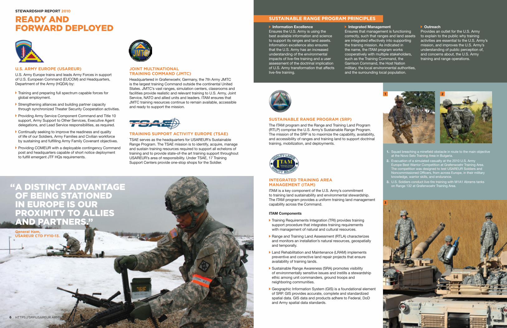
READY ANDFORWARD DEPLOYED
6 HTTPS://SRP.USAREUR.ARMY.MIL
U.S. ARMY EUROPE (USAREUR)
U.S. Army Europe trains and leads Army Forces in support of U.S. European Command (EUCOM) and Headquarters, Department of the Army (HQDA) by:
Training and preparing full spectrum capable forces for global employment.
Strengthening alliances and building partner capacity through synchronized Theater Security Cooperation activities.
Providing Army Service Component Command and Title 10 support, Army Support to Other Services, Executive Agent delegations, and Lead Service responsibilities, as required.
Continually seeking to improve the readiness and quality of life of our Soldiers, Army Families and Civilian workforce by sustaining and fulfilling Army Family Covenant objectives.
Providing COMEUR with a deployable contingency Command post and headquarters capable of short notice deployment to fulfill emergent JTF HQs requirements.
JOINT MULTINATIONAL TRAINING COMMAND (JMTC)
Headquartered in Grafenwoehr, Germany, the 7th Army JMTC is the largest training Command outside the continental United States. JMTC’s vast ranges, simulation centers, classrooms and facilities provide realistic and relevant training to U.S. Army, Joint Service, NATO and allied units and leaders. ITAM ensures that JMTC training resources continue to remain available, accessible and ready to support the mission.
TRAINING SUPPORT ACTIVITY EUROPE (TSAE)
TSAE serves as the headquarters for USAREUR’s Sustainable Range Program. The TSAE mission is to identify, acquire, manage and sustain training resources required to support all echelons of training and to provide state-of-the art training support throughout USAREUR’s area of responsibility. Under TSAE, 17 Training Support Centers provide one-stop shops for the Soldier.
SUSTAINABLE RANGE PROGRAM PRINCIPLES
Information ExcellenceEnsures the U.S. Army is using the best available information and science to support its ranges and land assets. Information excellence also ensures that the U.S. Army has an increased understanding of the environmental impacts of live-fire training and a user assessment of the doctrinal implication of U.S. Army transformation that affects live-fire training.
Integrated ManagementEnsures that management is functioning correctly, such that ranges and land assets are integrated effectively into supporting the training mission. As indicated in the name, the ITAM program works cooperatively with multiple stakeholders, such as the Training Command, the Garrison Command, the Host Nation military, the local environmental authorities, and the surrounding local population.
OutreachProvides an outlet for the U.S. Army to explain to the public why training activities are essential to the U.S. Army’s mission, and improves the U.S. Army’s understanding of public perception of, and concerns about, the U.S. Army training and range operations.
SUSTAINABLE RANGE PROGRAM (SRP)
The ITAM program and the Range and Training Land Program (RTLP) comprise the U.S. Army’s Sustainable Range Program. The mission of the SRP is to maximize the capability, availability, and accessibility of ranges and training land to support doctrinal training, mobilization, and deployments.
INTEGRATED TRAINING AREA MANAGEMENT (ITAM)
ITAM is a key component of the U.S. Army’s commitment to training land sustainability and environmental stewardship. The ITAM program provides a uniform training land management capability across the Command.
ITAM Components
Training Requirements Integration (TRI) provides training support procedure that integrates training requirements with management of natural and cultural resources.
Range and Training Land Assessment (RTLA) characterizes and monitors an installation’s natural resources, geospatially and temporally.
Land Rehabilitation and Maintenance (LRAM) implements preventive and corrective land repair projects that ensure availability of training lands.
Sustainable Range Awareness (SRA) promotes visibility of environmentally sensitive issues and instills a stewardship ethic among unit commanders, ground troops and neighboring communities.
Geographic Information System (GIS) is a foundational element of SRP. GIS provides accurate, complete and standardized spatial data. GIS data and products adhere to Federal, DoD and Army spatial data standards.
1. Squad breaching a minefield obstacle in route to the main objective at the Novo Selo Training Area in Bulgaria.
2. Evacuation of a simulated casualty at the 2010 U.S. Army Europe Best Warrior Competition at Grafenwoehr Training Area. The competition was designed to test USAREUR Soldiers and Noncommissioned Officers, from across Europe, in their military knowledge, warrior skills, and endurance.
3. U.S. Soldiers conduct live-fire training with M1A1 Abrams tanks on Range 132 at Grafenwoehr Training Area.“ A DISTINCT ADVANTAGE
OF BEING STATIONED IN EUROPE IS OUR PROXIMITY TO ALLIES AND PARTNERS.”
General Ham, USAREUR CTD FY10-13.
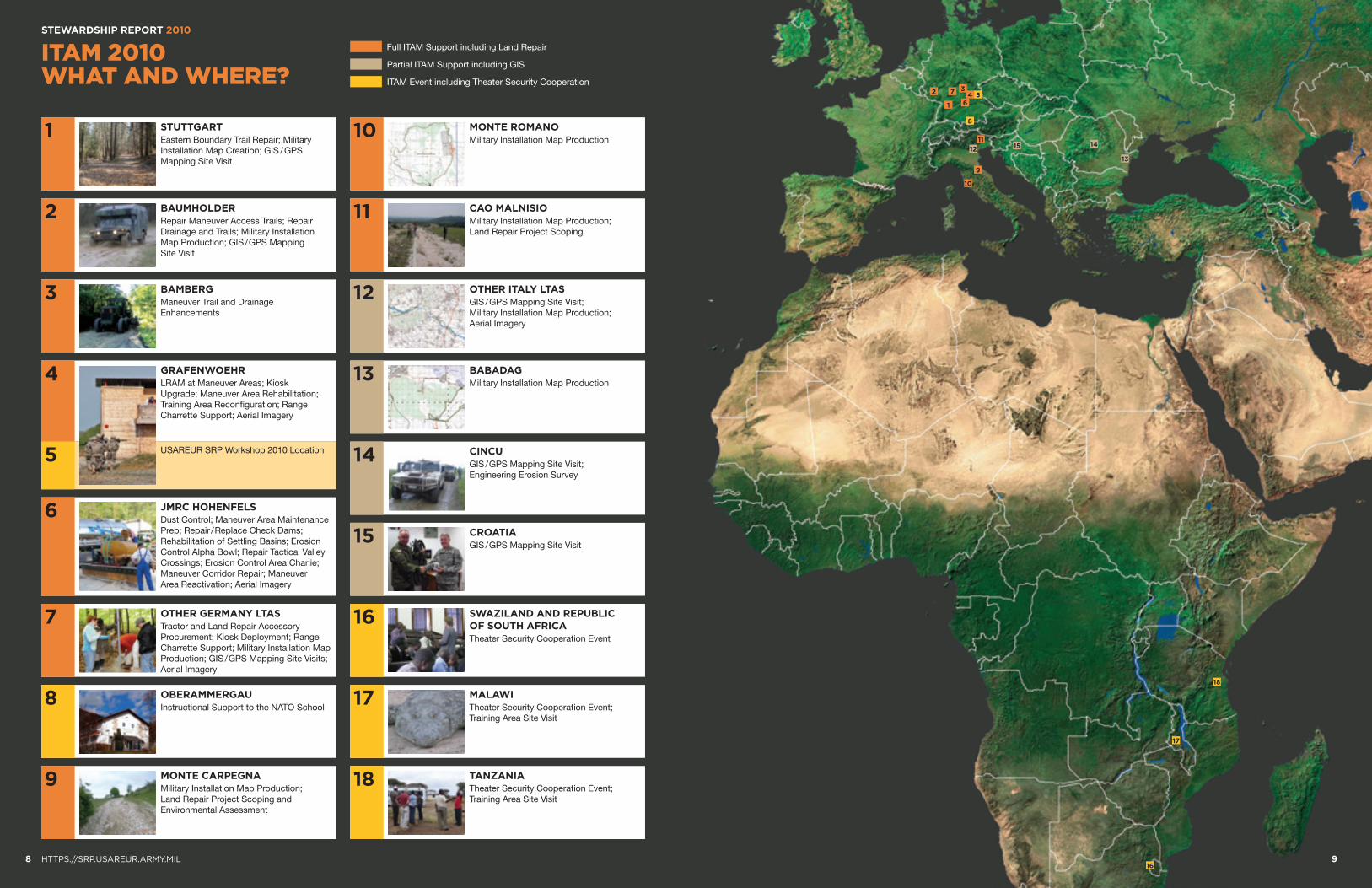
10
61
9
42
11
53
12
7
8
13
1415
17
18
168 HTTPS://SRP.USAREUR.ARMY.MIL 9
STEWARDSHIP REPORT 2010
ITAM 2010 WHAT AND WHERE?
Full ITAM Support including Land Repair
Partial ITAM Support including GIS
ITAM Event including Theater Security Cooperation
1 STUTTGARTEastern Boundary Trail Repair; Military Installation Map Creation; GIS / GPS Mapping Site Visit
2 BAUMHOLDERRepair Maneuver Access Trails; Repair Drainage and Trails; Military Installation Map Production; GIS / GPS Mapping Site Visit
3 BAMBERGManeuver Trail and Drainage Enhancements
5
6 JMRC HOHENFELSDust Control; Maneuver Area Maintenance Prep; Repair / Replace Check Dams; Rehabilitation of Settling Basins; Erosion Control Alpha Bowl; Repair Tactical Valley Crossings; Erosion Control Area Charlie; Maneuver Corridor Repair; Maneuver Area Reactivation; Aerial Imagery
7 OTHER GERMANY LTASTractor and Land Repair Accessory Procurement; Kiosk Deployment; Range Charrette Support; Military Installation Map Production; GIS / GPS Mapping Site Visits; Aerial Imagery
8 OBERAMMERGAUInstructional Support to the NATO School
10 MONTE ROMANOMilitary Installation Map Production
11 CAO MALNISIOMilitary Installation Map Production; Land Repair Project Scoping
12 OTHER ITALY LTASGIS / GPS Mapping Site Visit; Military Installation Map Production; Aerial Imagery
13 BABADAGMilitary Installation Map Production
14 CINCUGIS / GPS Mapping Site Visit; Engineering Erosion Survey
15 CROATIAGIS / GPS Mapping Site Visit
16 SWAZILAND AND REPUBLIC OF SOUTH AFRICATheater Security Cooperation Event
17 MALAWITheater Security Cooperation Event; Training Area Site Visit
18 TANZANIATheater Security Cooperation Event; Training Area Site Visit
9 MONTE CARPEGNAMilitary Installation Map Production; Land Repair Project Scoping and Environmental Assessment
4 GRAFENWOEHRLRAM at Maneuver Areas; Kiosk Upgrade; Maneuver Area Rehabilitation; Training Area Reconfiguration; Range Charrette Support; Aerial Imagery
USAREUR SRP Workshop 2010 Location
STEWARDSHIP REPORT 2010
1110 HTTPS://SRP.USAREUR.ARMY.MIL
ITAM 2010PROJECT CATALOG
JMRC HOHENFELSLRAM
Dust ControlDust from maneuver trails was reduced by applying calcium chloride, helping to improve safety for training units.
BAUMHOLDER LTALRAM
Repair Maneuver Access TrailsManeuver trails leading into TA1 were repaired and resurfaced with compacted gravel. Drainage structures were also repaired, erosion control measures constructed, and drainage ditches and culverts cleared of vegetation and debris.
GRAFENWOEHRLRAM
LRAM at Maneuver AreasApproximately 30ha of maneuver area located in the box north of Impact Area B and in PAs 252 / 253 were repaired. This project included decompaction, reseeding, and installation of minor erosion control structures.
GRAFENWOEHRLRAM
Maneuver Area RehabilitationLRAM bulk materials (i.e. top soil, reseeding material) were purchased to conduct LRAM projects, using internal labor, on maneuver training land. Locations included all TA /PA/ STX areas. A rugged dismounted trail north of Impact Area A was also constructed.
JMRC HOHENFELSLRAM
Repair Tactical Valley CrossingsExisting major maneuver valley crossings were repaired by hardening the soil surface where heavy traffic had damaged access points and by improving low points where water pooled and made them impassable. This allowed for increased accessibility and maneuverability within the training areas.
GRAFENWOEHRGIS
Aerial Imagery0.25 meter true color aerial orthoimagery was produced for Grafenwoehr Training Area.
JMRC HOHENFELSLRAM
Rehabilitation of Settling BasinsSettling basins around the outer perimeter of maneuver trails were maintained to minimize erosion and prevent off-post damages.
JMRC HOHENFELSGIS
Aerial Imagery0.25 meter true color aerial orthoimagery was produced for JMRC Hohenfels Training Area.
The USAREUR ITAM program received a big boost in 2010 from the execution of multiple, high impact projects. ITAM Coordinators and Training Support Center staffs were responsible for coordination and management of 24 land management projects covering almost all of USAREUR’s training areas. The project catalog provides a broad overview of how ITAM is increasing the availability, accessibility and capability of USAREUR’s training areas.
“ THE ARMY IS COMMITTED TO GOOD ENVIRONMENTAL STEWARDSHIP AND THE LONG-TERM SUSTAINABILITY OF ITS INSTALLATIONS.”
Mr. Addison D. Davis IV, Deputy Assistant Secretary of the Army (ESOH)
JMRC HOHENFELSLRAM
Repair / Replace Check DamsCheck dams were repaired and functionality maintained by removing sediments, repairing maneuver damages, and replacing check dam infrastructure.
GRAFENWOEHRGIS
Raised Relief Maps1K raised relief maps of Grafenwoehr Training Area and 500 raised relief maps of Europe were produced and disseminated to the USAREUR / JMTC Command and units.
GRAFENWOEHRSRA
Soldier Field CardsA new version of the Grafenwoehr Soldier Field Card was produced in English (20K) and in German (3K). This version has more detailed maps and is still provided in a pocket format.
JMRC HOHENFELSLRAM
Erosion Control Alpha BowlManeuver damage in the central portion of Alpha Bowl was repaired. Linear erosion gullies were leveled, recontoured, and reseeded; and rocks and level crossings were installed.
BAUMHOLDER LTALRAM
Repair Drainage and TrailsTrails, base lines and staging areas were resurfaced, and drainage from trails was restored. Vegetation was cleared; a boar barrier constructed; and culverts installed.
JMRC HOHENFELSLRAM
Maneuver Area Maintenance PrepThe training area was maintained by preparing all LRAM construction project sites through survey and removal of Unexploded Ordinance.
JMRC HOHENFELSLRAM
Maneuver Area ReactivationManeuver area was reconfigured and increased by removing off-limit markers. Maneuver trails and the existing network of erosion control structures were also repaired.
JMRC HOHENFELSRTLA
Land Cover ClassificationA 2010 land cover and change detection map was developed for JMRC Hohenfels and integrated into the existing land cover database for trend analysis.
1
2 3
STEWARDSHIP REPORT 2010
12 HTTPS://SRP.USAREUR.ARMY.MIL
ITAM 2010PROJECT CATALOG
13
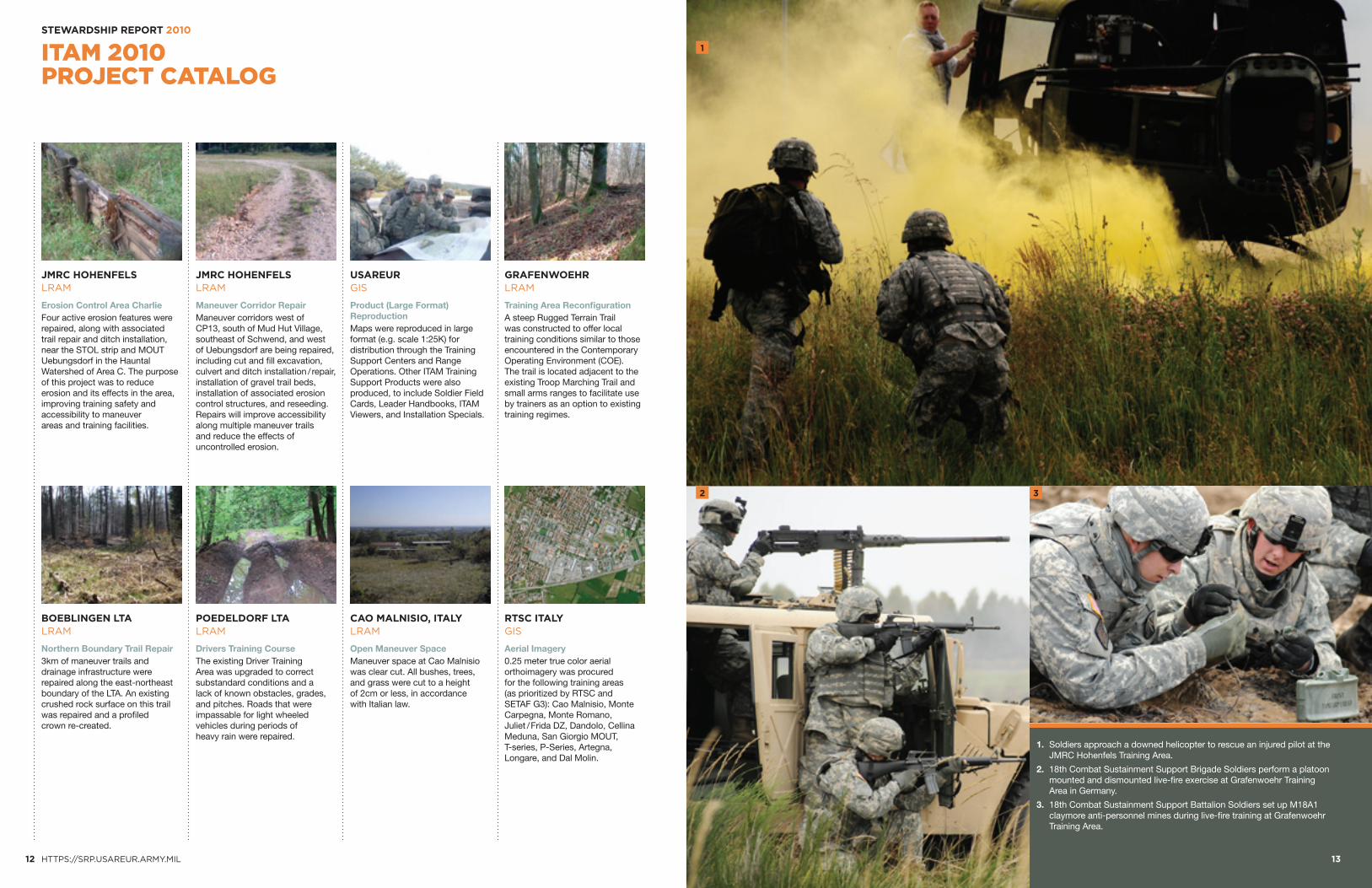
1. Soldiers approach a downed helicopter to rescue an injured pilot at the JMRC Hohenfels Training Area.
2. 18th Combat Sustainment Support Brigade Soldiers perform a platoon mounted and dismounted live-fire exercise at Grafenwoehr Training Area in Germany.
3. 18th Combat Sustainment Support Battalion Soldiers set up M18A1 claymore anti-personnel mines during live-fire training at Grafenwoehr Training Area.
JMRC HOHENFELSLRAM
Maneuver Corridor RepairManeuver corridors west of CP13, south of Mud Hut Village, southeast of Schwend, and west of Uebungsdorf are being repaired, including cut and fill excavation, culvert and ditch installation / repair, installation of gravel trail beds, installation of associated erosion control structures, and reseeding. Repairs will improve accessibility along multiple maneuver trails and reduce the effects of uncontrolled erosion.
POEDELDORF LTALRAM
Drivers Training CourseThe existing Driver Training Area was upgraded to correct substandard conditions and a lack of known obstacles, grades, and pitches. Roads that were impassable for light wheeled vehicles during periods of heavy rain were repaired.
JMRC HOHENFELSLRAM
Erosion Control Area CharlieFour active erosion features were repaired, along with associated trail repair and ditch installation, near the STOL strip and MOUT Uebungsdorf in the Hauntal Watershed of Area C. The purpose of this project was to reduce erosion and its effects in the area, improving training safety and accessibility to maneuver areas and training facilities.
BOEBLINGEN LTALRAM
Northern Boundary Trail Repair3km of maneuver trails and drainage infrastructure were repaired along the east-northeast boundary of the LTA. An existing crushed rock surface on this trail was repaired and a profiled crown re-created.
USAREURGIS
Product (Large Format) ReproductionMaps were reproduced in large format (e.g. scale 1:25K) for distribution through the Training Support Centers and Range Operations. Other ITAM Training Support Products were also produced, to include Soldier Field Cards, Leader Handbooks, ITAM Viewers, and Installation Specials.
CAO MALNISIO, ITALYLRAM
Open Maneuver SpaceManeuver space at Cao Malnisio was clear cut. All bushes, trees, and grass were cut to a height of 2cm or less, in accordance with Italian law.
GRAFENWOEHRLRAM
Training Area ReconfigurationA steep Rugged Terrain Trail was constructed to offer local training conditions similar to those encountered in the Contemporary Operating Environment (COE). The trail is located adjacent to the existing Troop Marching Trail and small arms ranges to facilitate use by trainers as an option to existing training regimes.
RTSC ITALYGIS
Aerial Imagery0.25 meter true color aerial orthoimagery was procured for the following training areas (as prioritized by RTSC and SETAF G3): Cao Malnisio, Monte Carpegna, Monte Romano, Juliet / Frida DZ, Dandolo, Cellina Meduna, San Giorgio MOUT, T-series, P-Series, Artegna, Longare, and Dal Molin.
BE
FO
RE
AF
TE
R
February 2009 May 2010
1 2 3 4
TRAINING AREAWORKINGGROUP
DPWEnvironmental
DPWOperations & Maintenance
DPWBuildings
& Grounds
MasterPlanner
GarrisonCommander
Federal RealEstate Agency
(BImA)
OperationsGroup S3
Safety
RE
MO
VE
D
OR
IGIN
AL
20
09
SU
RV
EY
DA
TA
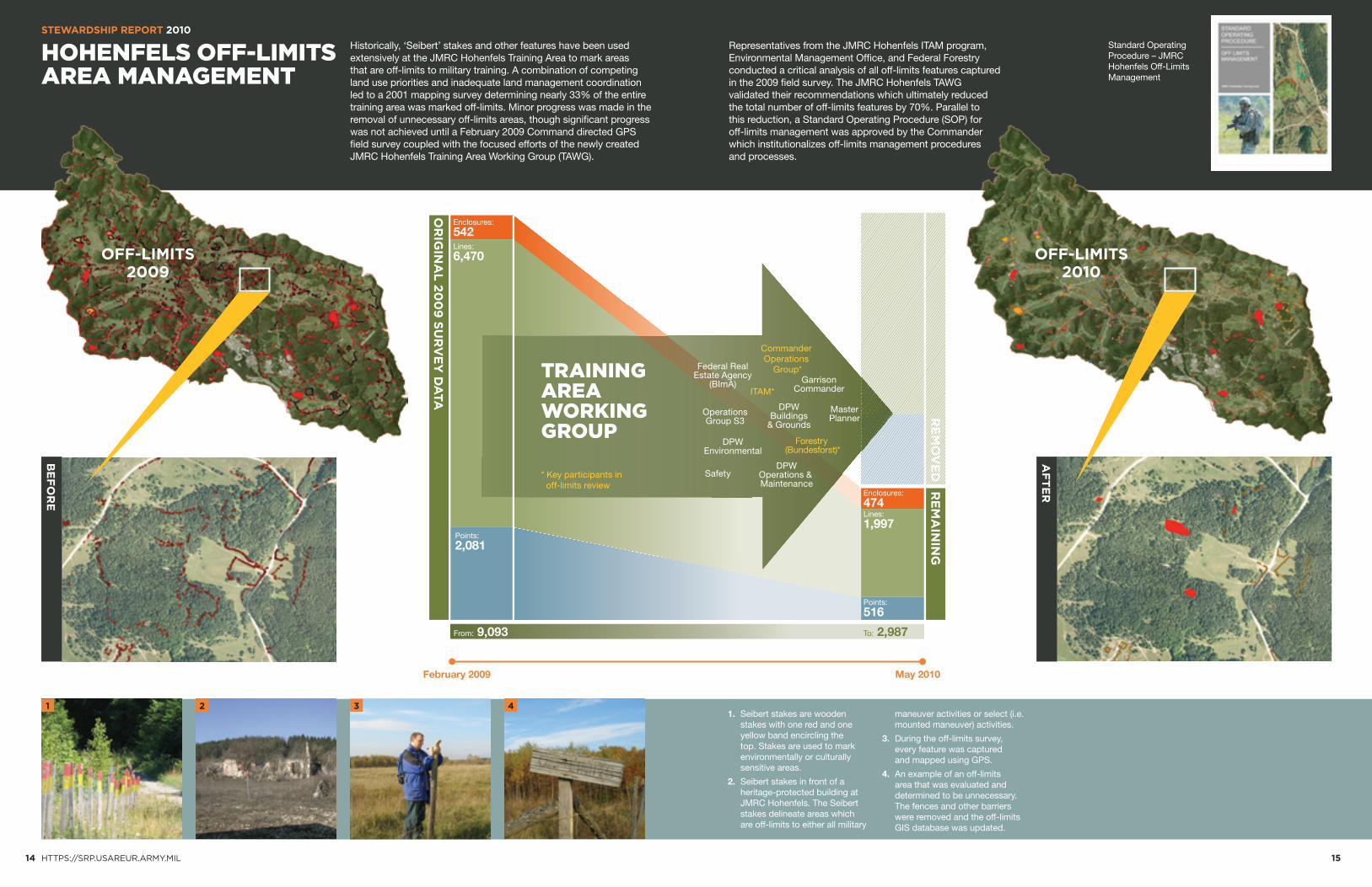
Enclosures: 542Lines: 6,470
Points: 2,081
Enclosures: 474Lines: 1,997
Points: 516
RE
MA
ININ
G
From: 9,093 To: 2,987
Commander Operations
Group*
Forestry (Bundesforst)*
ITAM*
* Key participants in off-limits review
Standard Operating Procedure – JMRC Hohenfels Off-Limits Management
14 HTTPS://SRP.USAREUR.ARMY.MIL 15
STEWARDSHIP REPORT 2010
HOHENFELS OFF-LIMITS AREA MANAGEMENT
Representatives from the JMRC Hohenfels ITAM program, Environmental Management Office, and Federal Forestry conducted a critical analysis of all off-limits features captured in the 2009 field survey. The JMRC Hohenfels TAWG validated their recommendations which ultimately reduced the total number of off-limits features by 70%. Parallel to this reduction, a Standard Operating Procedure (SOP) for off-limits management was approved by the Commander which institutionalizes off-limits management procedures and processes.
OFF-LIMITS2009
Historically, ‘Seibert’ stakes and other features have been used extensively at the JMRC Hohenfels Training Area to mark areas that are off-limits to military training. A combination of competing land use priorities and inadequate land management coordination led to a 2001 mapping survey determining nearly 33% of the entire training area was marked off-limits. Minor progress was made in the removal of unnecessary off-limits areas, though significant progress was not achieved until a February 2009 Command directed GPS field survey coupled with the focused efforts of the newly created JMRC Hohenfels Training Area Working Group (TAWG).
OFF-LIMITS2010
1. Seibert stakes are wooden stakes with one red and one yellow band encircling the top. Stakes are used to mark environmentally or culturally sensitive areas.
2. Seibert stakes in front of a heritage-protected building at JMRC Hohenfels. The Seibert stakes delineate areas which are off-limits to either all military
maneuver activities or select (i.e. mounted maneuver) activities.
3. During the off-limits survey, every feature was captured and mapped using GPS.
4. An example of an off-limits area that was evaluated and determined to be unnecessary. The fences and other barriers were removed and the off-limits GIS database was updated.
OPERATING ENVIRONMENT (OE)
TRAINING ENVIRONMENT (TE) USAREUR MAJOR TRAINING AREAS
AFGHANISTAN
1%
Water
0%2%
Agriculture(1km Buffer)
36%
0%
Roads
6%
1%
Urban
5%
Shrublands
45%
31%
3%
Forest
48%
Barren
8%
14%
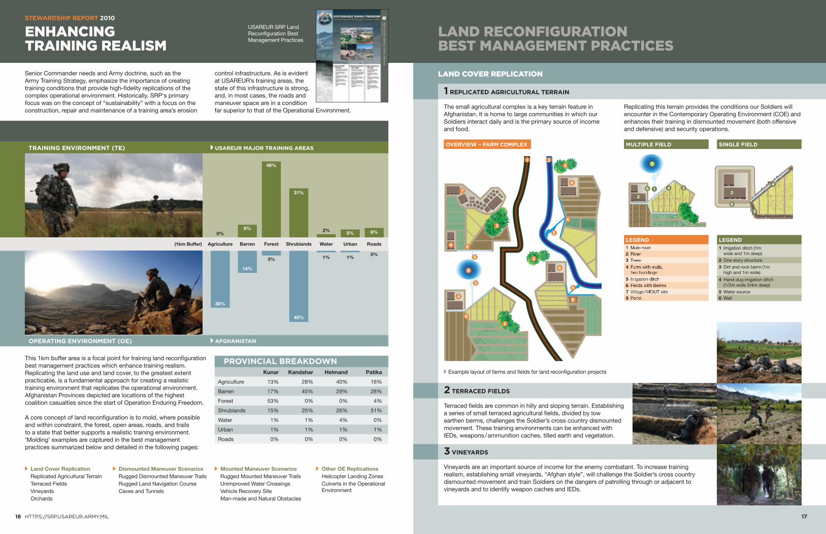
LAND COVER REPLICATION
The small agricultural complex is a key terrain feature in Afghanistan. It is home to large communities in which our Soldiers interact daily and is the primary source of income and food.
1 REPLICATED AGRICULTURAL TERRAIN
Terraced fields are common in hilly and sloping terrain. Establishing a series of small terraced agricultural fields, divided by low earthen berms, challenges the Soldier’s cross country dismounted movement. These training environments can be enhanced with IEDs, weapons / ammunition caches, tilled earth and vegetation.
2 TERRACED FIELDS
Vineyards are an important source of income for the enemy combatant. To increase training realism, establishing small vineyards, “Afghan style”, will challenge the Soldier’s cross country dismounted movement and train Soldiers on the dangers of patrolling through or adjacent to vineyards and to identify weapon caches and IEDs.
3 VINEYARDS
Replicating this terrain provides the conditions our Soldiers will encounter in the Contemporary Operating Environment (COE) and enhances their training in dismounted movement (both offensive and defensive) and security operations.
MULTIPLE FIELD SINGLE FIELD
3
OVERVIEW – FARM COMPLEX
4
7
1 2
3
6
6
5
5
8
4
3
3
4
5
6
5
6
4
3
1 Mainroad2 River3 Trees
4 Farmwithwalls, twobuildings
5 Irrigationditch6 FieldswithBerms7 Village/MOUTsite8 Pond
LEGEND
1 Irrigation ditch (1m wide and 1m deep)
2 One story structure
3 Dirt and rock berm (1m high and 1m wide)
4 Hand dug irrigation ditch (1/2m wide 3/4m deep)
5 Water source6 Wall
LEGEND
l
4 3
5
2
6 1
l
3
4
2
6
16 HTTPS://SRP.USAREUR.ARMY.MIL 17
STEWARDSHIP REPORT 2010
ENHANCING TRAINING REALISM
LAND RECONFIGURATION BEST MANAGEMENT PRACTICES
Land Cover Replication Replicated Agricultural Terrain Terraced Fields Vineyards Orchards
Dismounted Maneuver Scenarios Rugged Dismounted Maneuver Trails Rugged Land Navigation Course Caves and Tunnels
Mounted Maneuver Scenarios Rugged Mounted Maneuver Trails Unimproved Water Crossings Vehicle Recovery Site Man-made and Natural Obstacles
Other OE Replications Helicopter Landing Zones Culverts in the Operational
Environment
Senior Commander needs and Army doctrine, such as the Army Training Strategy, emphasize the importance of creating training conditions that provide high-fidelity replications of the complex operational environment. Historically, SRP's primary focus was on the concept of “sustainability” with a focus on the construction, repair and maintenance of a training area’s erosion
control infrastructure. As is evident at USAREUR’s training areas, the state of this infrastructure is strong, and, in most cases, the roads and maneuver space are in a condition far superior to that of the Operational Environment.
This 1km buffer area is a focal point for training land reconfiguration best management practices which enhance training realism. Replicating the land use and land cover, to the greatest extent practicable, is a fundamental approach for creating a realistic training environment that replicates the operational environment. Afghanistan Provinces depicted are locations of the highest coalition casualties since the start of Operation Enduring Freedom.
A core concept of land reconfiguration is to mold, where possible and within constraint, the forest, open areas, roads, and trails to a state that better supports a realistic training environment. ‘Molding’ examples are captured in the best management practices summarized below and detailed in the following pages:
Example layout of farms and fields for land reconfiguration projects
USAREUR SRP Land Reconfiguration Best Management Practices
PROVINCIAL BREAKDOWN Kunar Kandahar Helmand Patika
Agriculture 13% 28% 40% 16%
Forest 53% 0% 0% 4%
Water 1% 1% 4% 0%
Roads 0% 0% 0% 0%
Barren 17% 45% 29% 28%
Shrublands 15% 25% 26% 51%
Urban 1% 1% 1% 1%

Small orchards are a common agricultural feature in the COE. Establishing small orchards increase training realism by challenging the Soldier’s cross country dismounted movement and also provides cover and concealment for enemy fighters, weapons, and both buried and overhead IEDs. Orchards can have tall grass growing in them and walls surrounding them to increase the cover and concealment threat.
4 ORCHARDS
LAND COVER REPLICATION (CONT.) MOUNTED MANEUVER SCENARIOS
OTHER COE REPLICATIONS
In the COE trails leading to / from and around villages are frequently narrow or have steep slopes on each side that prevent vehicles from turning around or passing. Often these routes and trails have crater-like obstacles and corrugated metal culverts which support enemy direct and indirect fire and conceal ambushes, IEDs, and mines.
8 RUGGED MOUNTED MANEUVER TRAILS
The rugged terrain and dispersed units in Afghanistan require the establishment of unimproved hilltop and sloping terrain helicopter landing zone. Creating these conditions trains helicopter and ground units on their use and improves the coordination on planning and safe execution of landing zone selection and use.
12 HELICOPTER LANDING ZONES
Installing new culverts, or modifying existing ones, of various sizes and materials along mounted and dismounted trails provide Soldiers the opportunity to train on route clearing and security tasks and culvert denial techniques.
13 CULVERTS IN THE OPERATIONAL ENVIRONMENT
Commonly found in the COE are vehicle water crossings or dry river beds (Wadis) without improved fords and bridges. Often these areas include difficult slopes and turns which require ground guides and are potential ambush sites that conceal IEDs. Dismounted water crossing requires basic wire and cable bridge.
9 UNIMPROVED WATER CROSSINGS
Sites constrained by road width, slope, and natural or man-made obstacles (i.e. craters), “grab-n-go” recovery of destroyed and / or immobile vehicles are complicated and dangerous procedures in the COE.
10 VEHICLE RECOVERY SITE
Often man-made and natural obstacles on, or adjacent to, vehicle and dismounted routes could conceal enemy positions and IEDs. These items can include trash, abandoned equipment, destroyed / partially built structures, dams, ditches and curbs.
11 MAN-MADE AND NATURAL OBSTACLES
The terrain in Afghanistan is extremely rugged and poses challenges to physical conditioning and mission success. The Soldier must not only be fit, but also adept in traversing across difficult terrain. Establishing rugged maneuver trails complements the Soldier’s fitness training and enables techniques for traversing slopes, rocky terrain and other conditions while maintaining situational awareness.
5 RUGGED DISMOUNTED MANEUVER TRAILS
DISMOUNTED MANEUVER SCENARIOS
Soldiers and leaders need to improve their skills in land navigation, terrain / threat analysis, mapping, tactical maneuver, tactical site exploitation, and field craft in rugged terrain commonly found in the COE. A rugged land navigation course challenges the Soldier’s and leader’s ability to move from point to point across long distances over irregular terrain without established trails and clear line-of-sight.
6 RUGGED LAND NAVIGATION COURSE
Small caves and tunnels are an enemy asset and can be used to hide fighters and equipment, as well as serve as ambush sites. Establishing a cave and tunnel network provides Soldiers the opportunity to train on detecting, securing, clearing and nullifying these strategic sites.
7 CAVES AND TUNNELS
420
440
460
0 100 200 300 400 500 600 700Distance (m)
GTA Ruggest Terrain Trail Profile Graph Elevation change: ca. 59m / Total Length: 1500m
800 900 1,000 1,100 1,200 1,300 1,400 1,500
Ele
vatio
n (m
)
850 620 800 1,335 1,500 Length (m)
1 19 1 11 23 Avg Slope (%)
3 33 2 14 30 Max Slope (%)
I-J G-H E-F C-D A-B
H
J
IG
F
E
C
A
B
D
GTA Rugged Terrain Trail – Trail stretches A-J
LEGENDTrail Stretch A-B
Trail Stretch E-F
Trail Stretch I-J
Trail Stretch C-D
Trail Stretch G-H
Tank Trail
Lakes
Boundary
450M
480M
415M
DETAIL TRAIL STRECH A-B
18 HTTPS://SRP.USAREUR.ARMY.MIL 19
STEWARDSHIP REPORT 2010
LAND RECONFIGURATION BEST MANAGEMENT PRACTICES
1000 Meters5000
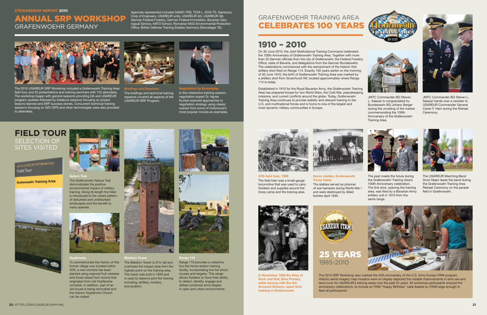
JMTC Commander BG Steven L. Salazar is congratulated by Bundeswehr BG Johann Berger during the unveiling of the marker commemorating the 100th Anniversary of the Grafenwoehr Training Area.
GTA field train, 1909The field train was a small-gauge locomotive that was used to carry Soldiers and supplies around the troop camp and the training area.
The past meets the future during the Grafenwoehr Training Area’s 100th Anniversary celebration. The first shot, opening the training area, was fired by a Bavarian Army artillery unit in 1910 from the same range.
Horse stables, Grafenwoehr Troop CampThe stables served as prisoner of war barracks during World War I and were destroyed by Allied bombs April 1945.
The USAREUR Marching Band Drum Major leads the band during the Grafenwoehr Training Area Retreat Ceremony on the parade field in Grafenwoehr.
JMTC Commander BG Steven L. Salazar hands over a canister to USAREUR Commander General Carter F. Ham during the Retreat Ceremony.
20 HTTPS://SRP.USAREUR.ARMY.MIL 21
ANNUAL SRP WORKSHOPGRAFENWOEHR GERMANY
GRAFENWOEHR TRAINING AREA
CELEBRATES 100 YEARS
STEWARDSHIP REPORT 2010
1910 – 2010
FIELD TOURSELECTION OF SITES VISITED
Nature TrailThe Grafenwoehr Nature Trail demonstrates the positive environmental impact of military training. Along its length the hiker is introduced to the varied pattern of disturbed and undisturbed landscapes and the benefit to many species.
Bleidorn TowerThe Bleidorn Tower is 27m tall and overlooks the impact area from the highest point on the training area. The tower was built in 1926 and is used to observe joint fire training including; artillery, mortars, and aviation.
HopfenoheTo commemorate the history of this former village now located within GTA, a new orchard has been planted using regional fruit varieties and those raised from scions that originated from old Hopfenohe orchards. In addition, part of an old house is being renovated and the historic Hopfenohe Church can be visited.
Range 118Range 118 provides a collective live-fire home-station training facility, incorporating live-fire shoot houses and targetry. This range allows Soldiers to hone their ability to detect, identify, engage and defeat combined arms targets in open and urban environments.
The 2010 USAREUR SRP Workshop included a Grafenwoehr Training Area field tour, and 35 presentations and training seminars with 125 attendees. The workshop began with general sessions providing DA and USAREUR program updates followed by breakout sessions focusing on project lessons learned and SRP success stories. Concurrent technical training sessions focusing on GIS / GPS and other technologies were also provided to attendees.
Briefings and SessionsThe briefings and technical training sessions covered all aspects of the USAREUR SRP Program.
Negotiation by ScreenplayIn this interactive training session, negotiation expert Dr. Agnes Kunkel explored approaches to negotiation strategy using classic scenes from some of Hollywood’s most popular movies as examples.
On 30 June 2010, the Joint Multinational Training Command celebrated the 100th Anniversary of Grafenwoehr Training Area. Together with more than 25 German officials from the city of Grafenwoehr, the Federal Forestry Office, state of Bavaria, and delegations from the German Bundeswehr. The celebrations commenced with the reenactment of the historic first artillery shot fired on Range 114. Exactly 100 years earlier on the morning of 30 June 1910, the birth of Grafenwoehr Training Area was marked by a artillery shot from Gruenhund Hill, located approximately where Range 114 is today.
Established in 1910 for the Royal Bavarian Army, the Grafenwoehr Training Area has prepared troops for two World Wars, the Cold War, peacekeeping missions, and current conflicts around the globe. Today, Grafenwoehr Training Area continues to provide realistic and relevant training to the U.S. and multinational forces and is home to one of the largest and most dynamic military communities in Europe.
25 YEARS1985-2010
The 2010 SRP Workshop also marked the 25th anniversary of the U.S. Army Europe ITAM program. Historic aerial imagery map mosaics were on display depicted the notable improvements in land use and land cover for USAREUR’s training areas over the past 25 years. All workshop participants enjoyed the anniversary celebrations, to include an ITAM “Happy Birthday” cake (baked by ITAM) large enough to feed all participants!
In November 1958 the King of Rock and Roll, Elvis Presley, while serving with the 3rd Armored Division, spent time training in Grafenwoehr.
Agencies represented included DAMO-TRS, TCM-L, DOS-TS, Garrisons, Corp of Engineers, USAREUR units, USAREUR G3, USAREUR G8, German Federal Forestry, German Federal Immobilien, Bavarian Geo-logical Service, NATO School, Romanian MoD Environmental Protection Office, British Defense Training Estates-Germany (Sennelager TA).
PROPONENT DATE EVENT LOCATION PARTICIPANTS LEVEL TYPE
STEWARDSHIP REPORT 2010
22 HTTPS://SRP.USAREUR.ARMY.MIL 23
SUSTAINABLE RANGE AWARENESS EVENTS
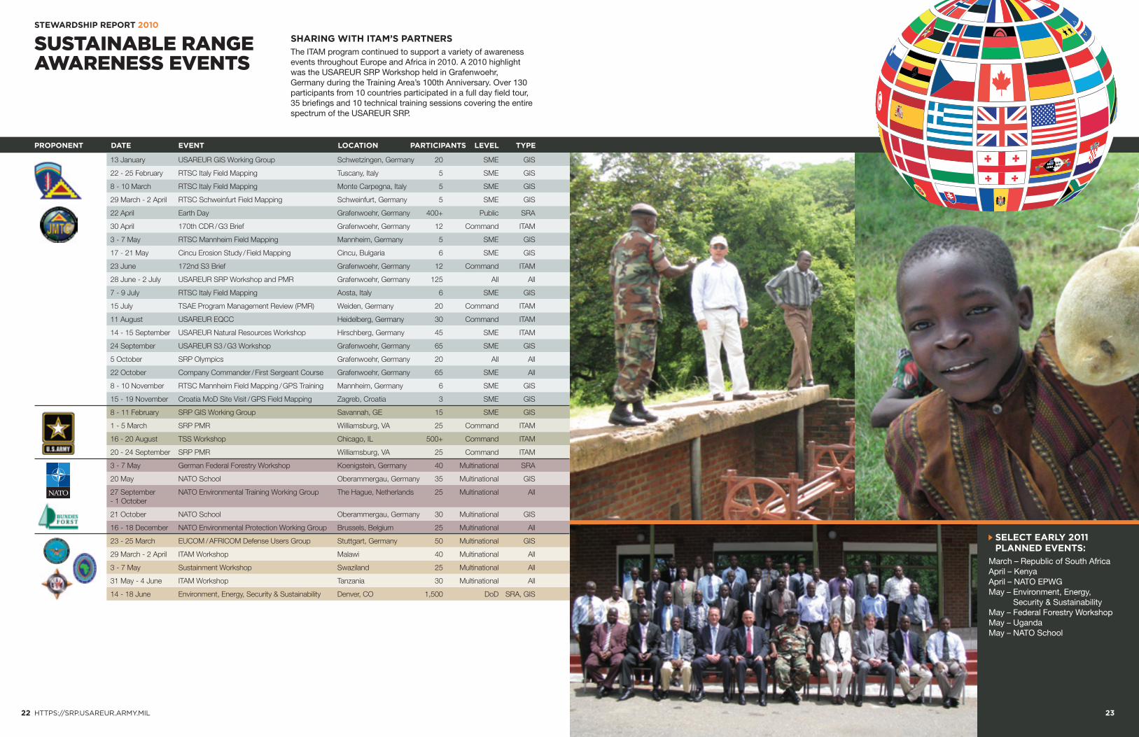
SHARING WITH ITAM’S PARTNERS
The ITAM program continued to support a variety of awareness events throughout Europe and Africa in 2010. A 2010 highlight was the USAREUR SRP Workshop held in Grafenwoehr, Germany during the Training Area’s 100th Anniversary. Over 130 participants from 10 countries participated in a full day field tour, 35 briefings and 10 technical training sessions covering the entire spectrum of the USAREUR SRP.
13 January USAREUR GIS Working Group Schwetzingen, Germany 20 SME GIS
22 - 25 February RTSC Italy Field Mapping Tuscany, Italy 5 SME GIS
8 - 10 March RTSC Italy Field Mapping Monte Carpegna, Italy 5 SME GIS
29 March - 2 April RTSC Schweinfurt Field Mapping Schweinfurt, Germany 5 SME GIS
22 April Earth Day Grafenwoehr, Germany 400+ Public SRA
30 April 170th CDR / G3 Brief Grafenwoehr, Germany 12 Command ITAM
3 - 7 May RTSC Mannheim Field Mapping Mannheim, Germany 5 SME GIS
17 - 21 May Cincu Erosion Study / Field Mapping Cincu, Bulgaria 6 SME GIS
23 June 172nd S3 Brief Grafenwoehr, Germany 12 Command ITAM
28 June - 2 July USAREUR SRP Workshop and PMR Grafenwoehr, Germany 125 All All
7 - 9 July RTSC Italy Field Mapping Aosta, Italy 6 SME GIS
15 July TSAE Program Management Review (PMR) Weiden, Germany 20 Command ITAM
11 August USAREUR EQCC Heidelberg, Germany 30 Command ITAM
14 - 15 September USAREUR Natural Resources Workshop Hirschberg, Germany 45 SME ITAM
24 September USAREUR S3 / G3 Workshop Grafenwoehr, Germany 65 SME GIS
5 October SRP Olympics Grafenwoehr, Germany 20 All All
22 October Company Commander / First Sergeant Course Grafenwoehr, Germany 65 SME All
8 - 10 November RTSC Mannheim Field Mapping / GPS Training Mannheim, Germany 6 SME GIS
15 - 19 November Croatia MoD Site Visit / GPS Field Mapping Zagreb, Croatia 3 SME GIS
8 - 11 February SRP GIS Working Group Savannah, GE 15 SME GIS
1 - 5 March SRP PMR Williamsburg, VA 25 Command ITAM
16 - 20 August TSS Workshop Chicago, IL 500+ Command ITAM
20 - 24 September SRP PMR Williamsburg, VA 25 Command ITAM
3 - 7 May German Federal Forestry Workshop Koenigstein, Germany 40 Multinational SRA
20 May NATO School Oberammergau, Germany 35 Multinational GIS
27 September NATO Environmental Training Working Group The Hague, Netherlands 25 Multinational All- 1 October
21 October NATO School Oberammergau, Germany 30 Multinational GIS
16 - 18 December NATO Environmental Protection Working Group Brussels, Belgium 25 Multinational All
23 - 25 March EUCOM / AFRICOM Defense Users Group Stuttgart, Germany 50 Multinational GIS
29 March - 2 April ITAM Workshop Malawi 40 Multinational All
3 - 7 May Sustainment Workshop Swaziland 25 Multinational All
31 May - 4 June ITAM Workshop Tanzania 30 Multinational All
14 - 18 June Environment, Energy, Security & Sustainability Denver, CO 1,500 DoD SRA, GIS
SELECT EARLY 2011 PLANNED EVENTS:
March – Republic of South Africa April – Kenya April – NATO EPWG May – Environment, Energy,
Security & SustainabilityMay – Federal Forestry Workshop May – Uganda May – NATO School
FREIHOELSER FORST GRAFENWOEHR
JMRC HOHENFELS ALTENGRABOW
ALTENWALDE ALTMARK
BAD REICHENHALL BERGEN · DAADEN
EHRA LESSIEN GARLSTEDT
HALTERN BORKENBERGE HALTERN LAVESUM
HAMMELBURG HEUBERG
ISTC PFULLENDORF JAEGERBRUECK KLIETZ · LEHNIN
LUEBTHEEN MITTENWALD
MUNSTER NORD SUED NORDHORN
OBERLAUSITZ OBERVIECHTACH
OHRDRUF · PUTLOS REGENSBURG
REITERALPE MOUNTAIN RANGE RODING · ROTH
SCHWARZENBORN SIEGENBURG TODENDORF
TRAUNSTEIN · WEIDEN 2 WILDFLECKEN
WITTSTOCK · BUDEL BAUMHOLDER BREITENWALD
CHIEVRES GRIESHEIM 6910
KLEBER KASERNE MAINZ LAYENHOF
MAINZ SAND DUNES OFFENHEIM
RHEINBLICK · ROB WACKERNHEIM
BOEBLINGEN LAMPERTHEIM
OFTERSHEIM PATRICK HENRY VILLAGE
PATTON BARRACKS SCHWETZIGEN
APPENDORF · BUG BURGEBRACH
COLMBERG CONN BARRACKS
DITTELBRUNN KUNIGUNDENRUH
OBERDACHSTETTEN PFAENDHAUSEN
POEDELDORF REESE RANGE
ROTTERSHAUSEN SCHESSLITZ
SOUTH HAUPTSMOOR SULZHEIM · URLAS
CAMP DARBY AND LIVORNO CAO MALNISIO
CELLINA MEDUNA DAL MOLIN · DANDOLO
EDERLE AND RIVERSIDE FOCE DEL RENO
LONGARE MONTE CARPEGNA
MONTE ROMANO SAN GIORGIO QARAHEYBAT
BEZMER AIRBASE KOREN · NOVO SELO
BOLETICE HRADISTE · JINCE
LIBAVA · TAPA VAZIANI · VARPALOTA
CAMP BONDSTEEL TANTAN
DRAWSKO POMORSKIE NADARZYCE
WEDRZYN BABADAG · CINCU
MIHAIL KOGALNICEANU AIRBASE ROMANIA OVERVIEW
SMARDAN · MOLINO SAN GREGORIO
CAP SERRAT · JAVORIV
24 25
GEOGRAPHIC INFORMATION SYSTEM
ARMY RANGEMAPPER
STEWARDSHIP REPORT 2010 PRODUCTS AND SERVICES
SETTING A NEW STANDARD IN WEB BASED MAPPING
AUTHORITATIVE GEOSPATIAL RESOURCESSRP GIS achieves information dominance by delivering the most accurate and complete spatial data sets through user-friendly products and applications. SRP GIS, spearheaded by the ITAM program, provides a standardized geospatial situational awareness of the installation battle space to support all SRP projects and initiatives. In the past five years, the USAREUR SRP GIS geospatial repository has become, arguably, the authoritative source for training area and range geospatial data.
The products shown on the following pages are produced and distributed through the USAREUR Training Support Centers and the Grafenwoehr SRP Regional Support Center free of charge to U.S. Soldiers and DoD civilians. Their further distribution is restricted.
REGIONAL SUPPORT CENTER The Grafenwoehr Sustainable Range Program Regional Support Center (SRP RSC) provides a hub and spoke GIS support network for all USAREUR training areas and ranges. The RSC brings years of experience and established procedures to the ITAM program.
The Grafenwoehr SRP RSC is one of two worldwide. It provides geospatial support to over 180 U.S. and foreign training areas and Forward Operating Sites. The primary function of the RSC is to ensure a standard GIS capability and to gain efficiencies through centralized support. The RSC focuses on the development of standard GIS databases and provides GIS products and applications to SRP and other mission support offices. Spatial data is provided through many types of media; paper and digital maps, internet mapping applications, and a DVD desktop interface that allows the user to access the GIS database.
HTTPS://SRP.USAREUR.ARMY.MIL
2010 STATISTICS
HITS
1,048,749
VISITS
6,528
UNIQUE USERS
1,871
NEW TRAINING SUPPORT KIOSKS
All ITAM range and training area maps are also available from the TSAE Kiosks located at Grafenwoehr Range Operations and select Training Support Centers (TSC). In addition to PDF maps and the ability to create new maps using the ITAM Viewer, Kiosk users can also obtain information on TSC assets, Deployable Instrumentation System – Europe (DISE), and the Training Aids Production Center (TAPC). Customers can print letter and large format maps directly to the Kiosk printer.
The following quantifications provide a broad overview of GIS production and support in 2010.
1,048,749page hits on the USAREUR SRP website (https://srp.usareur.army.mil)
25 Draft Military Installation Maps (MIMs) created for USAREUR training areas
17 new aerial imagery overflights and satellite imagery acquisition projects coordinated by the SRP GIS team
5 TSAE Kiosks located throughout USAREUR
14,507Total Interactions
KIOSK STATISTICS
21 GIS briefings or training sessions provided at Army workshops and events in Europe and the U.S.
14 RTLP Range Modernization Projects supported by GIS
7,863Downloaded Maps
7,500Installation Special Maps produced for Local Training Areas (LTAs) in Germany
5,000Draft Military Installation Maps (MIMs) produced
2,227Raised Relief Maps distributed covering ten areas
68%of all GIS data requests submitted by U.S. Soldiers
591Data Request Forms (DRFs) submitted, processed and fulfilled
25 site visits to USAREUR and host nation training areas for GIS data collection and validation
62,000Soldiers field cards printed and distributed throughout USAREUR
2,471ITAM Viewer DVD sets distributed throughout USAREUR
82 USAREUR training areas compliant with SRP GIS data strategy requirements and published to IGI&S Army Mapper
6,528visits to the USAREUR SRP website
The power of information is directly proportional to its (controlled) accessibility. The USAREUR SRP website provides information on the ITAM program as well as the latest training news from the USAREUR community. The website is also a convenient portal to all SRP GIS products and services. The USAREUR SRP website (https://srp.usareur.army.mil) provides a single NIPRNET solution for training area imagery and vector data and a suite of powerful geospatial tools. SRP’s most popular on-line tool, the Army Range Mapper (ARM), distributes worldwide GIS data to Soldiers, trainers, planners, and range control personnel. The ARM is one of the most utilized training support web resources in the USAREUR community.
1,871Unique users of the USAREUR SRP website
Body text goes here
27
PRODUCTS AND SERVICES
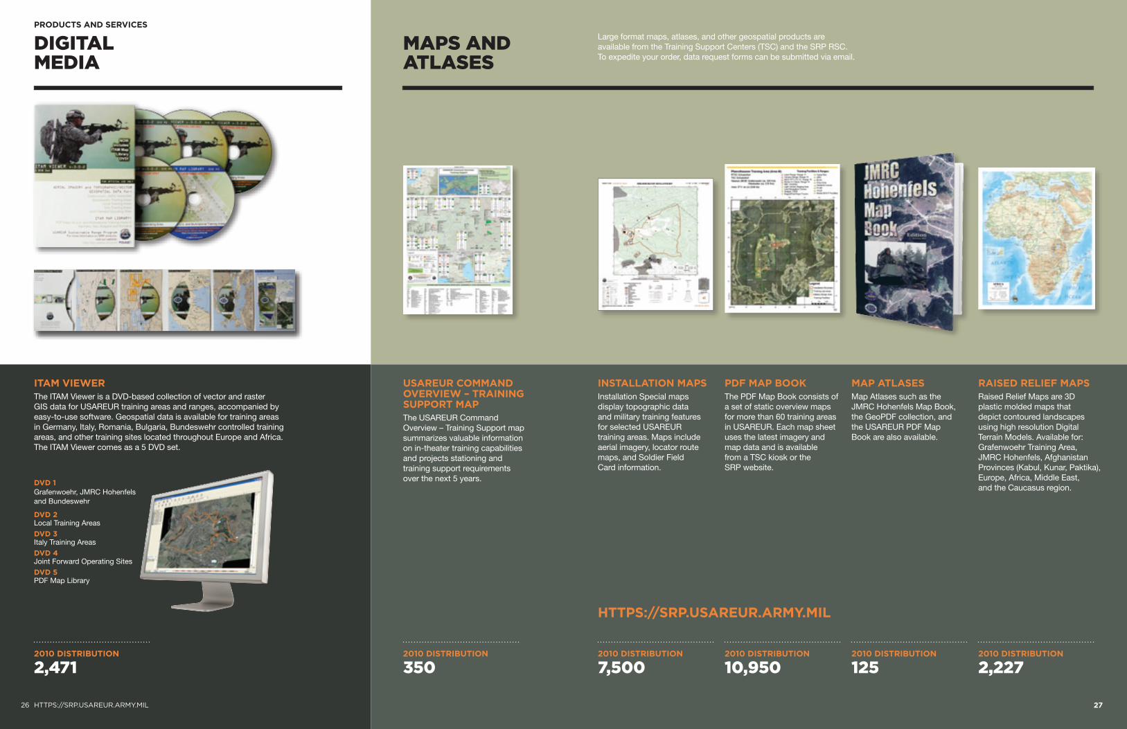
ITAM VIEWER The ITAM Viewer is a DVD-based collection of vector and raster GIS data for USAREUR training areas and ranges, accompanied by easy-to-use software. Geospatial data is available for training areas in Germany, Italy, Romania, Bulgaria, Bundeswehr controlled training areas, and other training sites located throughout Europe and Africa. The ITAM Viewer comes as a 5 DVD set.
26 HTTPS://SRP.USAREUR.ARMY.MIL
DIGITAL MEDIA
MAPS AND ATLASES
USAREUR COMMAND OVERVIEW – TRAINING SUPPORT MAPThe USAREUR Command Overview – Training Support map summarizes valuable information on in-theater training capabilities and projects stationing and training support requirements over the next 5 years.
INSTALLATION MAPS Installation Special maps display topographic data and military training features for selected USAREUR training areas. Maps include aerial imagery, locator route maps, and Soldier Field Card information.
PDF MAP BOOK The PDF Map Book consists of a set of static overview maps for more than 60 training areas in USAREUR. Each map sheet uses the latest imagery and map data and is available from a TSC kiosk or the SRP website.
MAP ATLASES Map Atlases such as the JMRC Hohenfels Map Book, the GeoPDF collection, and the USAREUR PDF Map Book are also available.
RAISED RELIEF MAPS Raised Relief Maps are 3D plastic molded maps that depict contoured landscapes using high resolution Digital Terrain Models. Available for: Grafenwoehr Training Area, JMRC Hohenfels, Afghanistan Provinces (Kabul, Kunar, Paktika), Europe, Africa, Middle East, and the Caucasus region.
HTTPS://SRP.USAREUR.ARMY.MIL
DVD 1Grafenwoehr, JMRC Hohenfels and Bundeswehr
DVD 2 Local Training Areas
DVD 3 Italy Training Areas
DVD 4Joint Forward Operating Sites
DVD 5PDF Map Library
Large format maps, atlases, and other geospatial products are available from the Training Support Centers (TSC) and the SRP RSC. To expedite your order, data request forms can be submitted via email.
2010 DISTRIBUTION
2,4712010 DISTRIBUTION
7,5002010 DISTRIBUTION
3502010 DISTRIBUTION
10,9502010 DISTRIBUTION
1252010 DISTRIBUTION
2,227
28 HTTPS://SRP.USAREUR.ARMY.MIL 29
OTHER PRODUCTS
PRODUCTS AND SERVICES
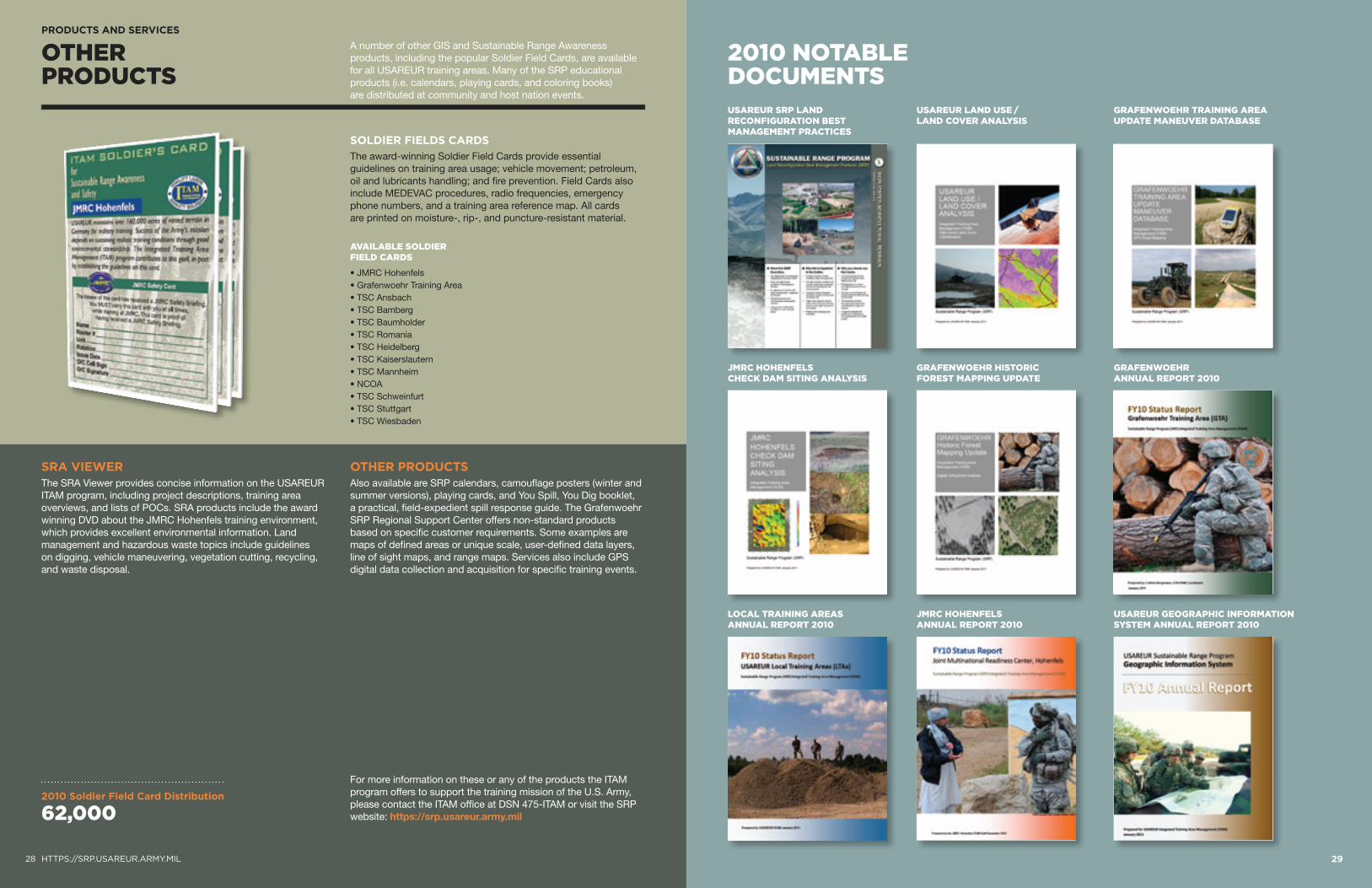
A number of other GIS and Sustainable Range Awareness products, including the popular Soldier Field Cards, are available for all USAREUR training areas. Many of the SRP educational products (i.e. calendars, playing cards, and coloring books) are distributed at community and host nation events.
2010 NOTABLE DOCUMENTS
SRA VIEWER The SRA Viewer provides concise information on the USAREUR ITAM program, including project descriptions, training area overviews, and lists of POCs. SRA products include the award winning DVD about the JMRC Hohenfels training environment, which provides excellent environmental information. Land management and hazardous waste topics include guidelines on digging, vehicle maneuvering, vegetation cutting, recycling, and waste disposal.
OTHER PRODUCTS Also available are SRP calendars, camouflage posters (winter and summer versions), playing cards, and You Spill, You Dig booklet, a practical, field-expedient spill response guide. The Grafenwoehr SRP Regional Support Center offers non-standard products based on specific customer requirements. Some examples are maps of defined areas or unique scale, user-defined data layers, line of sight maps, and range maps. Services also include GPS digital data collection and acquisition for specific training events.
SOLDIER FIELDS CARDS
The award-winning Soldier Field Cards provide essential guidelines on training area usage; vehicle movement; petroleum, oil and lubricants handling; and fire prevention. Field Cards also include MEDEVAC procedures, radio frequencies, emergency phone numbers, and a training area reference map. All cards are printed on moisture-, rip-, and puncture-resistant material.
AVAILABLE SOLDIER FIELD CARDS
• JMRC Hohenfels • Grafenwoehr Training Area • TSC Ansbach • TSC Bamberg • TSC Baumholder • TSC Romania • TSC Heidelberg • TSC Kaiserslautern • TSC Mannheim • NCOA • TSC Schweinfurt • TSC Stuttgart • TSC Wiesbaden
For more information on these or any of the products the ITAM program offers to support the training mission of the U.S. Army, please contact the ITAM office at DSN 475-ITAM or visit the SRP website: https://srp.usareur.army.mil
2010 Soldier Field Card Distribution
62,000
GRAFENWOEHR TRAINING AREA UPDATE MANEUVER DATABASE
USAREUR SRP LAND RECONFIGURATION BEST MANAGEMENT PRACTICES
USAREUR LAND USE / LAND COVER ANALYSIS
GRAFENWOEHR ANNUAL REPORT 2010
JMRC HOHENFELS CHECK DAM SITING ANALYSIS
GRAFENWOEHR HISTORIC FOREST MAPPING UPDATE
USAREUR GEOGRAPHIC INFORMATION SYSTEM ANNUAL REPORT 2010
LOCAL TRAINING AREAS ANNUAL REPORT 2010
JMRC HOHENFELS ANNUAL REPORT 2010
2010 DISTRIBUTION
X,XXX
30 HTTPS://SRP.USAREUR.ARMY.MIL
FUNDING AND WAY AHEAD
STEWARDSHIP REPORT 2010
Department of the Army and USAREUR continued to provide strong funding support to the ITAM program in fiscal year (FY) 2010. The Army supports ITAM’s critical role in sustaining and enhancing the training land platform.
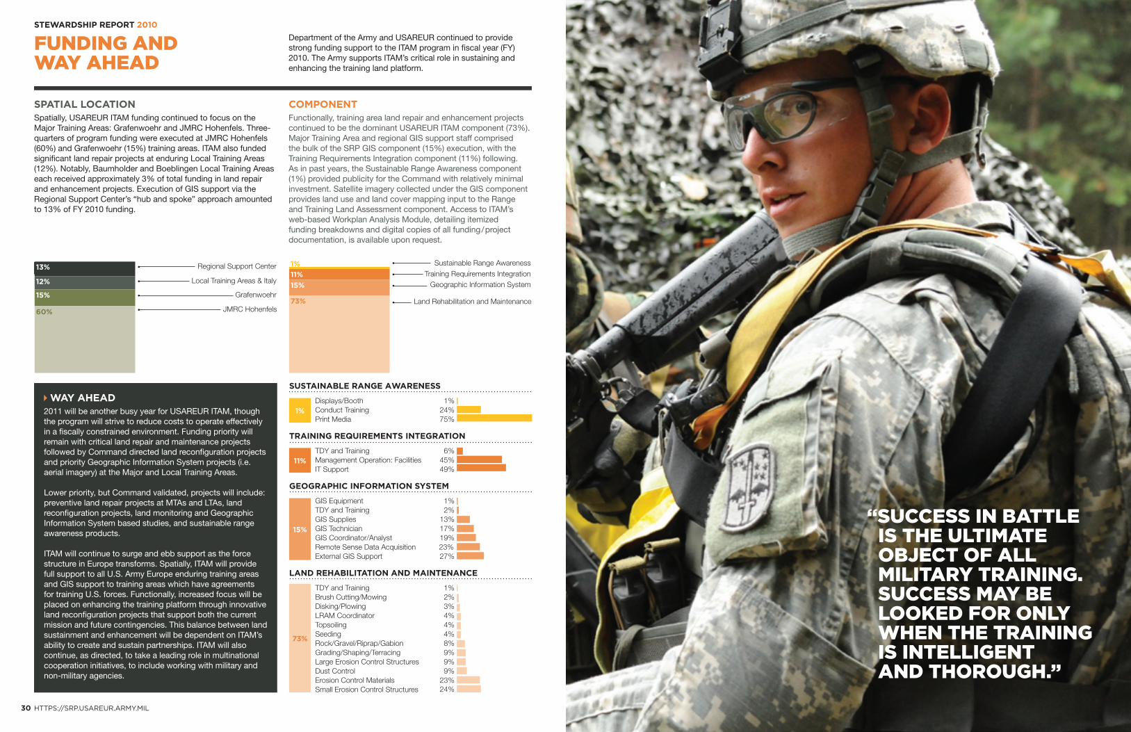
SPATIAL LOCATIONSpatially, USAREUR ITAM funding continued to focus on the Major Training Areas: Grafenwoehr and JMRC Hohenfels. Three-quarters of program funding were executed at JMRC Hohenfels (60%) and Grafenwoehr (15%) training areas. ITAM also funded significant land repair projects at enduring Local Training Areas (12%). Notably, Baumholder and Boeblingen Local Training Areas each received approximately 3% of total funding in land repair and enhancement projects. Execution of GIS support via the Regional Support Center’s “hub and spoke” approach amounted to 13% of FY 2010 funding.
COMPONENTFunctionally, training area land repair and enhancement projects continued to be the dominant USAREUR ITAM component (73%). Major Training Area and regional GIS support staff comprised the bulk of the SRP GIS component (15%) execution, with the Training Requirements Integration component (11%) following. As in past years, the Sustainable Range Awareness component (1%) provided publicity for the Command with relatively minimal investment. Satellite imagery collected under the GIS component provides land use and land cover mapping input to the Range and Training Land Assessment component. Access to ITAM’s web-based Workplan Analysis Module, detailing itemized funding breakdowns and digital copies of all funding / project documentation, is available upon request.
“SUCCESS IN BATTLE IS THE ULTIMATE OBJECT OF ALL MILITARY TRAINING. SUCCESS MAY BE LOOKED FOR ONLY WHEN THE TRAINING IS INTELLIGENT AND THOROUGH.”
SUSTAINABLE RANGE AWARENESS
Displays/Booth 1%Conduct Training 24%Print Media 75%
TRAINING REQUIREMENTS INTEGRATION
TDY and Training 6%Management Operation: Facilities 45%IT Support 49%
GEOGRAPHIC INFORMATION SYSTEM
GIS Equipment 1%TDY and Training 2%GIS Supplies 13%GIS Technician 17%GIS Coordinator/Analyst 19%Remote Sense Data Acquisition 23%External GIS Support 27%
LAND REHABILITATION AND MAINTENANCE
TDY and Training 1%Brush Cutting/Mowing 2%Disking/Plowing 3%LRAM Coordinator 4%Topsoiling 4%Seeding 4%Rock/Gravel/Riprap/Gabion 8%Grading/Shaping/Terracing 9%Large Erosion Control Structures 9%
9%Dust Control Erosion Control Materials 23%Small Erosion Control Structures 24%
Regional Support Center
Local Training Areas & Italy
JMRC Hohenfels
Grafenwoehr
13%
12%
15%
60%
11%
1%
15%
73%
Sustainable Range Awareness
Geographic Information SystemTraining Requirements Integration
Land Rehabilitation and Maintenance
1%
11%
15%
73%
WAY AHEAD2011 will be another busy year for USAREUR ITAM, though the program will strive to reduce costs to operate effectively in a fiscally constrained environment. Funding priority will remain with critical land repair and maintenance projects followed by Command directed land reconfiguration projects and priority Geographic Information System projects (i.e. aerial imagery) at the Major and Local Training Areas.
Lower priority, but Command validated, projects will include: preventive land repair projects at MTAs and LTAs, land reconfiguration projects, land monitoring and Geographic Information System based studies, and sustainable range awareness products.
ITAM will continue to surge and ebb support as the force structure in Europe transforms. Spatially, ITAM will provide full support to all U.S. Army Europe enduring training areas and GIS support to training areas which have agreements for training U.S. forces. Functionally, increased focus will be placed on enhancing the training platform through innovative land reconfiguration projects that support both the current mission and future contingencies. This balance between land sustainment and enhancement will be dependent on ITAM’s ability to create and sustain partnerships. ITAM will also continue, as directed, to take a leading role in multinational cooperation initiatives, to include working with military and non-military agencies.
HTTPS://SRP.USAREUR.ARMY.MIL
For further information or copies of this Stewardship Report, please contact the ITAM office: +49 (0)9641-83-ITAM or [email protected]
Photos primarily provided by Training Support Activity Europe Visual Information.Printed on The Forest Stewardship Council (FSC) certified paper. Products with an FSC label come from forests certified as being in compliance with the environmental and social standards of the Forest Stewardship Council.


![[ADOPTED 9/23/2010] DELTA STEWARDSHIP COUNCIL I. … · 2020. 4. 3. · [adopted 9/23/2010] delta stewardship council i. administrative procedures governing appeals ii. statutory](https://img.pdfslide.us/doc/110x75/5fecdea1e3316e3c4f5ca062/adopted-9232010-delta-stewardship-council-i-2020-4-3-adopted-9232010.jpg)