Embed Size (px)
Citation preview

2008 IRIS Workshop
June 4–6 • Skamania Lodge • Stevenson, WA


2008 IRIS Workshop
Program Information
ScIence ProgrAm chAIrSSuzan van der Lee - Northwestern UniversityJohn Vidale - University of Washington
Pre-WorkShoP eventS Tuesday, June 3• USArrayMagnetotelluric(MT)FootprintSelection StevensonC;9:30a.m.-4:30p.m.• IntroductiontoMultinodeComputingUsingMPI
(MessagePassingInterface) StevensonD;9:00a.m.-5:00p.m.• TheFutureofControlled-SourceSeismology Jefferson;1:30p.m.-5:00p.m.• IRISDMCTutorial:DiggingintoJWEED,IRISDMC’s
Event-BasedDataRequestTool Rainier;1:00p.m.-5:00p.m.
PoSt-WorkShoP eventSSaturday, June 7• AntelopeUsersGroup
PoSter SeSSIonSPostersessionsarelocatedinHood,Adams,andtheRedBluffMezzanineonthemainlevel.Posternumbersarelocatedinthefirstcolumnofthetableintheposterindexofthisprogram.Tolocateyourassignedposterboard,lookfortheboardmarkedwiththisnumber.
Youmayhangyourposteranytimeafter7:00p.m.onTuesday,June3,orbetween7:00a.m.and8:00a.m.onWednesday,June4.Youmayremoveyourposteranytimeafter3:15p.m.onFriday,June6,butitmustberemovedby6:00p.m.
FIeLd trIPYoumustberegisteredtoattendthefieldtrip.FieldtripattendeesshouldfirstgrababoxedlunchfromtheCascadeLocksBallroomthenmeetinthehotellobbyat12:15p.m.Thebuseswillreturntothehotelatapproximately6:00p.m.
KeckcAveSTheW.M.KeckCenterforActiveVisualizationintheEarthSciences(KeckCAVES)isajointprojectbetweentheUCDavisDepartmentofGeology,IDAV,andtheUCDavisComputationalScienceandEngineeringCenter(CSE)tobringastate-of-the-artimmersivevisualizationfacilitytoearthscienceresearchers.KeckCAVES’centerpieceisafour-sided10’x10’x8’CAVE(threerear-projectedwallsandfront-projectedfloor),designedandbuiltbyFakespaceSystems,Inc.Besidesbeingahigh-endimmersivevisualizationfacility,KeckCAVESisalsoacollaborativeenvironmentwherecomputerscientistdevelopersandusersfromtheEarth(orother)sciencescometogethertodevelopcutting-edgesoftwareforinteractiveexplorationandanalysisofcomplex3Ddata.SoftwaredevelopedatKeckCAVESfollowsauser-drivenapproachgivingscientiststoolstoextractinsightfromdata,andrunsnotonlyonimmersiveenvironmentslikeCAVEs,butalsoonlower-endstereoscopicdisplaysystemsandevenstandarddesktopandlaptopcomputers.KeckCAVESalsofollowsanopenphilosophy:softwaredevelopedfor,andtestedat,KeckCAVESismadeavailabletothepublicunderopen-sourcesoftwarelicensesonanongoingbasis.
KeckCaveswillbeondisplaythroughoutthemeetinginSummit 4.

AIrPort ShuttLe InFormAtIonBlueStarShuttlehasofferedadiscountedrateof$38.50perperson(oneway)forIRISWorkshopparticipants.Fortransportationtotheairport,reservationsarerequired,andcanbemadebycalling1-800-247-2272atleastonedayinadvance.YoumustletthemknowyouarewiththeIRISgrouptoreceivedthediscountedrate.TransportationtoPDXoperatesfrom3:00a.m.-12:00a.m.
Internet AcceSSWireless,high-speedInternetaccessiscomplimentaryintheguestroomsandpublicareasofthelodge.Publicareasincludethemainlobby,RiverRockLounge,thefitnesscenter,andthemaindiningroom.Forwirelessaccessinthemeetingroom,youwillneedtopurchaseausernameandpasswordfromthebusinesscenter.Theserviceratesformeetingroomconnectionsareonaperconnection,perdaybasis.TheTechnologyResourceRoom,locatedintheConferenceCenterlobby,hashardwireInternetaccesspoints,aswellasPCsforyouruse.

CONFERENCECENTERLOBBY
GARDENTERRACE
SEQUOIATERRACE
BAKERMEETING
ROOM
ST.HELENMEETING
ROOM
RANIERMEETING
ROOM
GALLERY
REDBLUFF
MEZZANINE
ELEV
DATACENTER
SUMMIT 1
SUMMIT 2
SUMMIT 3SUMMIT 4HOOD
MEETINGROOM
ADAMSMEETING
ROOM
DECKDECK
STORAGESTORAGE
STORAGE
STEVENSONBALLROOM "A"
STEVENSONBALLROOM "B"
STEVENSONBALLROOM "C"
STEVENSONBALLROOM "D"
CASCADE LOCKSBALLROOM "A"
CASCADE LOCKSBALLROOM "B"
MEADOW ROOM(LOCATED OFF MAIN LOBBY)
Main LevelConference Floorplan
WASHINGTONMEETING
ROOM
GLACIERHALL
BOULDERSTERRACE
ELEV
VEST
IBUL
EJEFFERSONMEETING
ROOMSUMMIT 6 SUMMIT 5
PLAN
TER SUMMIT 8 SUMMIT 9 STORAGE
PLAN
TER
SUMMIT 7
SERV
.
MECH
WOMEN'S
MEN'S
Lower Level Conference Floorplan
TO H
OTEL
BOULDERTERRACE
(LOWER LEVEL)
SKAMANIA LODGE CONFERENCE CENTER
PlenarySessions
RegistrationBreaks
MealsEveningPrograms
PosterSessions
GUEST ROOMS
GUES
TROO
MS
CONFERENCEWING
WAL
KING
PATH
FRON
T EN
TRY
DRIV
EWAY
GARD
ENTE
RRAC
E
DRIVEWAY
RED BLUFF
MEZZ
PARK
ING
OUTD
OOR
SPA/
SUN
DECK
INDO
OR P
OOL/
SPA/
FITN
ESS
CENT
ER
PLAY AR
EA
FITNE
SS
PRO
SHOP
GREE
N SI
DE
GRIL
L
TO L
ODGE
FRON
T EN
TRY
AMPH
ITHE
ATER
WOO
DLAN
DLA
WN
WOO
DED
AREA
PARK
ING
PARK
ING
WAL
KING
PATH
WALKINGPATH
HIKING PATH
EMPL
OYEE
PARK
ING
LOT
PARKING
COLU
MBIA
GOR
GE IN
TERP
RETIV
E CE
NTER
DRIVE
WAY
TENN
IS A
NDBA
SKET
BALL
COUR
T
BOUL
DER
PATI
O&
TERR
ACE
MEAD
OWRO
OM&
MEAD
OWPA
TIO
THE
CASC
ADE
ROOM
THE
GORG
ERO
OM
CONF
EREN
CEBU
SINE
SSCE
NTER
SEQU
OIA
TERR
ACE
VOLL
EYBA
LLCO
URT
COLU
MBIA
RIV
ER
PART
IALL
YCO
VERE
DDR
IVIN
GRA
NGE
GOLF COURSE
GOLF
COUR
SEGO
LF C
OURS
EGO
LFCO
URSE
FRON
TLA
WN
CASC
ADE
LAW
N
PUTT
ING
GREE
N
YURT
S/BB
QAR
EA
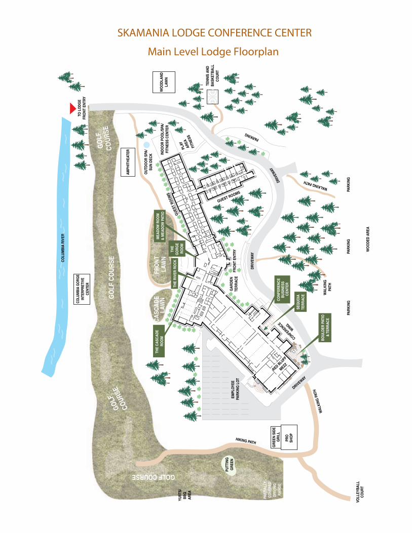
SKAMANIA LODGE CONFERENCE CENTER
Main Level Lodge Floorplan


2008 IRIS Workshop
Agenda
WedneSdAy, June 4 eArth Structure reSeArch
6:30a.m.- regIStrAtIon ConferenceCenterLobby
7:00a.m.-8:00a.m. contInentAL BreAkFASt CascadeLocksBallroom
8:00a.m.-8:30a.m. WeLcome And overvIeW oF IrIS StevensonAandBDavidSimpsonandSusanBeck
8:30a.m.-10:30a.m. PLenAry SeSSIon StevensonAandB
PuShIng the LImItS: IntegrAtIon oF ActIve And PASSIve SeISmIc ImAgIng; IntegrAtIon oF SeISmoLogy And mInerAL PhySIcS
Organizers:SuzanvanderLeeandFrancisWu
The middle Asian Active Source (mAnAS) Profile: Preliminary results from an Integrated Seismic transect in the tien Shan of kyrgyzstan and china
JamesH.Knapp
3-d Structure of the Se caribbean Plate Boundary: Integration of Active Source Seismic data receiver Functions and Surface Wave tomography
MeghanS.Miller
Joint Interpretation of tAIger Passive and Active Source data for Imaging the orogen FrancisWu
Imaging crustal Faults in kanto, Japan, with meSo-net and Active Source data NaoshiHirata
hydrogen in the upper mantle: Are Water-rich regions red or Blue? ThomasDuffy
10:30 a.m. - 10:45 a.m. BreAk ConferenceCenterLobby
10:45a.m.-12:15p.m. PoSter SeSSIon Hood,Adams,andRedBluffMezzanine
Pushing the Limits: Integration of Active and Passive Seismic Imaging; Integration of Seismology and mineral Physics
teaching Seismology
12:15p.m.-1:30p.m. Lunch CascadeLocksBallroom

1:30p.m.-2:00p.m. overvIeW oF eArthScoPe And uSArrAy StevensonAandB BobWoodward
2:00p.m.-4:00p.m. PLenAry SeSSIon StevensonAandB
trAnSPortABLe ArrAy/uSArrAy: trAnSFormAtIve ScIence, technoLogy, And cuLture
Organizers:MikeRitzwoller,EdGarnero
new constraints on mantle Seismic Structure Beneath the northwestern united States MatthewFouch
The Fate of the Juan de Fuca Plate RichardAllen
Surface Waves Across the tA: An Integrated Seismic and geodynamic Analysis of mantle deformation Beneath california
JamesGaherty
Ambient Seismic noise and teleseismic tomography in the Western uSA: high-resolution 3-d Images of the crust and upper mantle from earthScope/uSArray
YingjieYang
4:00p.m.-4:15p.m. BreAk ConferenceCenterLobby
4:15p.m.-5:15p.m. Long rAnge ScIence PLAn For SeISmoLogy StevensonAandB RichardAster,DonForsyth,ThorneLay,andBarbaraRomanowicz
5:15p.m.-6:15p.m. SPecIAL IntereSt grouP meetIngS
Broadband owners group Baker MattFouchandJimFowler
Best Practices for teaching Seismology to undergraduates Stevenson C GlenKroegerandLauraWetzel
tA Siting, Adopt-a-Station, and eArn Jefferson BobBusbyandPerleDorr
IrIS Polar Projects Stevenson D RhettButler,KentAnderson,andJimFowler
6:30p.m.-7:30p.m. dInner CascadeLocksBallroom
7:30p.m.- evenIng ProgrAm WIth coFFee And deSSert CascadeLocksBallroom viewing the earth from the Inside out: Insights from Scientific
visualization and Science-Art-technology collaboration LouiseKelloggandOliverKreylos

thurSdAy, June 5 PoLAr ActIvIty
6:30a.m.- regIStrAtIon ConferenceCenterLobby
7:00a.m.-8:00a.m. contInentAL BreAkFASt CascadeLocksBallroom
8:00a.m.-10:00a.m. PLenAry SeSSIon StevensonAandBSeISmoLogy, geodeSy, And Ice dynAmIcS In PoLAr regIonS
Organizers:DougWiensandGöranEkström
glacier Flow and glacial earthquakes in greenland MeredithNettles
Slip Slidin’ Away: glacier Flow and Seismicity SridharAnandakrishnan
Seismic radiation from Icebergs DouglasMacAyeal
10:00 a.m. - 10:15 a.m. BreAk ConferenceCenterLobby
10:15 a.m. - 11:45 a.m. PoSter SeSSIon Hood,Adams,andRedBluffMezzanine
deep earth Structure
IrIS Facilities
Seismology, geodesy, and Ice dynamics in Polar regions
transportable Array/uSArray: transformative Science, technology, and culture
11:45 a.m. BoXed Lunch CascadeLocksBallroom
12:15p.m.-6:00p.m. FIeLd trIP: LAndSLIdeS, deLugeS, And vItIcuLture (Pre-registrationrequired) ScottBurnsandJimO’Connor Registrantsshouldgrabtheirboxlunchesthenmeetinthehotellobbyat12:15
6:30p.m.-7:30p.m. dInner CascadeLocksBallroom
7:30p.m.- evenIng ProgrAm WIth coFFee And deSSert CascadeLocksBallroom music and creativity in 100 Level earth Science classes EdGarnero,PaulSilver,DavidBell,andSethMoran

FrIdAy, June 6 SeISmIc event reSeArch/eArthquAke ScIence
6:30a.m.- regIStrAtIon ConferenceCenterLobby
7:00a.m.-8:00a.m. contInentAL BreAkFASt CascadeLocksBallroom
8:00a.m.-10:00a.m. PLenAry SeSSIon StevensonAandB
BreAkIng the eArthquAke moLd: ePISodIc tremor And SLIP Organizers:JohnVidaleandGregBeroza
episodic tremor and Slip in cascadia KenCreager
episodic tremor and Slip in Japan SatoshiIde
dancing with the Plates: Watching Faults Shimmy and Shake MichaelBrudzinski
10:00 a.m. - 10:15 a.m. BreAk ConferenceCenterLobby
10:15 a.m. - 11:15 a.m. SPecIAL IntereSt grouP meetIngS
mobile real-time networks for Aftershock Warning and Study Baker PaulDavisandMarcosAlvarez
After the earthquake: communicating to the media and general Public Stevenson C KevinFurlongandJohnTaber
handling data from uSArray and PASScAL experiments Stevenson D GaryPavlisandBobBusby
Synthetic Seismogram Server for global cmts Jefferson JeroenTromp,GöranEkström,ValaHjörleifsdóttir,andPaulFriberg
11:15a.m.-12:15p.m. SPecIAL IntereSt grouP meetIngS
PASScAL Program review Stevenson D AlanLevanderandJimFowler
Seismac, quakecatcher, and netquakes Stevenson C MichaelWysessionandElizabethCochran
data quality Assessment for the transportable Array Jefferson BobWoodward,GaryPavlis,andBobBusby
IrIS Software Working group Baker ChuckAmmonandBobWoodward
12:15p.m.-1:30p.m. Lunch CascadeLocksBallroom

1:30p.m.-3:15p.m. PoSter SeSSIon Hood,Adams,andRedBluffMezzanine
Breaking the earthquake mold: episodic tremor and Slip
Synergy in Seismic event monitoring
3:15p.m.-3:30p.m. BreAk ConferenceCenterLobby
3:30p.m.-3:45p.m. overvIeW oF eArthquAke hAzArd PoLIcy StevensonAandB ArtLerner-LamandDavidApplegate
3:45p.m.-5:45p.m. PLenAry SeSSIon StevensonAandB
Synergy In SeISmIc event monItorIng And reSeArch Organizers:ChuckAmmon,FelixWaldhauser
Lessons from the transportable Array for Seismic monitoring Douglas Dreger
The many roles of a regional Seismic network SteveMalone
Stealing gold from the Ivory tower: uSgS national earthquake Information center’s collaborations with the Academic community
PaulEarle
A novel use of global Seismic network for Fast tsunami Warning HirooKanamori
6:00p.m.- outdoor BBq FrontLawn


2008 IRIS Workshop
PostersAllposterswillbedisplayedthroughoutthemeeting.
Presentersshouldbeavailableduringthepostersessiononthedayindicated.
WedneSdAy, June 8
Pushing the Limits: Integration of Active and Passive Seismic Imaging; Integration of Seismology and mineral Physics
Poster#
51 MeghanS.Miller 3DSTRUCTUREOFTHESECARIBBEANPLATEBOUNDARY:INTEGRATIONOFACTIVESOURCESEISMICDATA,RECEIVERFUNCTIONS,ANDSURFACEWAVETOMOGRAPHY
52 NaoshiHirata IMAGINGCRUSTALFAULTSINKANTO,JAPAN,WITHMESO-NETANDACTIVESOURCEDATA
53 Sung-Joon Chang JOINTINVERSIONFOR3-DIMENSIONALS-VELOCITYSTRUCTUREANDRADIALANISOTROPYINTHEMANTLEALONGTHETETHYANMARGIN
54 DavidAbt SHEAR-WAVESPLITTINGTOMOGRAPHYINCENTRALAMERICAANDTHEIMPLICATIONSFORMANTLEWEDGEFLOW
55 HaijiangZhang REGIONALTHREE-DIMENSIONALSEISMICVELOCITYMODELOFTHECRUSTANDUPPERMOSTMANTLEOFNORTHERNCALIFORNIA
56 MichaelBostock EXTRACTIONOFABSOLUTEP-VELOCITYFROMRECEIVERFUNCTIONS
57 KrisVasudevan SKELETON-MIGRATIONINDEEPCRUSTALSEISMICPROFILING
58 Colleen Dalton RADIALLYANISOTROPICCRUSTALVELOCITYSTRUCTUREOFNWCANADAFROMAMBIENT-NOISETOMOGRAPHY
59 ShuqinMa MAPPINGTHELITHOSPHEREANDASTHENOSPHEREBOUNDARYINSOUTHERNAFRICABYSRECEIVERFUNCTIONS
60 GerardoLeonSoto SEISMICANISOTROPYANDMANTLEDYNAMICSINTHERIVERASUBDUCTIONZONE
61 AhyiKim COMPARISONBETWEENTWO3DVELOCITYSTRUCTURESINTHESANFRANCISCOBAYAREA
62 Chingwen Chen RAYLEIGHWAVEDISPERSIONANALYSISINTHELOWERGREATLAKESREGION
63 RobertHawman CRUSTALROOTSANDVP/VSVARIATIONSINTHESOUTHERNAPPALACHIANS:ACOMPARISONOFRECEIVERFUNCTIONSWITHMIGRATEDSECTIONSDERIVEDFROMTHREE-COMPONENT,WIDE-ANGLEP&SREFLECTIONDATA
64 PaulSilver EVIDENCEFORACOMPOSITIONALBOUNDARYWITHINTHELITHOSPHERICMANTLEBENEATHTHEKALAHARICRATONFROMSRECEIVERFUNCTIONS
65 AndrewSchaeffer SEISMICLOWVELOCITYZONEBENEATHTHESLAVECRATONCHARACTERIZEDUSINGPANDSRECEIVERFUNCTIONS
66 RaymondM.Russo SHEARWAVESPLITTINGANDSEISMICVELOCITYSTRUCTUREOFTHECHILERIDGESUBDUCTIONREGION
67 HaoKuo-Chen S-SPLITTINGMEASUREMENTSANDTHETAIWANOROGENY
68 En-JuiLee IMAGINGTHEUPPERMANTLESTRUCTUREUNDERTAIWAN—ATAIGERPROJECT
69 FrancisWu JOINTINTERPRETATIONOFTAIGERPASSIVEANDACTIVESOURCEDATAFORIMAGINGTHEOROGEN

70 PhilWannamaker MODESOFLITHOSPHERICDISMEMBERMENT,MAGMATICINPUT,ANDIMPLICATIONSFORRHEOLOGICALMODELSOFTHEGREATBASINANDCOLORADOPLATEAUREGIONS,NEVADAANDUTAH;IMPLICATIONSFROMDEEPMTRESISTIVITYSURVEYING
71 MichaelLandes UPPERMANTLESTRUCTUREOFTHECARIBBEAN-SOUTHAMERICANPLATEBOUNDARY
72 AlexanderHanna RAYLEIGHWAVEPHASEVELOCITYSTRUCTUREOFTHENANGAPARBATHARAMOSHMASSIFUSINGPASSIVESOURCES
73 David Okaya CRUSTALIMAGINGOFTHEEURASIAN-PHILIPPINESEAPLATEBOUNDARYINTAIWAN:THETAIGER2008LANDREFRACTIONEXPERIMENT
74 RishengChu DETACHEDEURASIANMANTLELITHOSPHERESBENEATHTHETIBETANPLATEAUINFERREDFROMTRIPLICATEDPWAVEFORMS
75 Jean-PhilippeMercier
PANDSBODY-WAVETOMOGRAPHYOFWESTERNCANADA
76 AhmetOkeler SURFACEWAVEIMAGINGOFTHESOUTHERNAPENNINESUSINGTRANSPORTABLEARRAYDATA
77 AnneTrehu LOWANGLETHRUSTEARTHqUAKESINTHE“LOCKEDZONE”BENEATHTHECENTRALCASCADIACONTINENTALMARGIN
78 RobertMellors CRUSTALSTRUCTUREOFTHECAUCASUSANDCASPIANREGIONFROMRECEIVERFUNCTIONS
79 MinChen ADJOINTTOMOGRAPHYOFTHEDESCENDINGSLABINTHEJAPANSUBDUCTIONZONE
80 DonHelmberger MULTI-PATHDETECTORS,I.METHOD
81 Daoyuan Sun MULTI-PATHDETECTORS,II.APPLICATIONS
82 CameliaKnapp SOUTHEASTERNCARPATHIANFORELANDDEFORMATIONINRELATIONTOTHEVRANCEASEISMOGENICZONEOFROMANIA:RESULTSFROMACTIVEANDPASSIVESOURCESEISMICDATA
83 Eva-MariaRumpfhuber
INTEGRATEDCONTROLLED-SOURCEANDPASSIVESEISMICANALYSISBYTHECD-ROMPROJECTINTHEROCKIES
84 JeffreyPark MOHOVARIATIONSACROSSTHENORTHERNAPENNINESCONVERGENCEZONE:HUNTINGFORASUBDUCTION-INDUCEDDIVIDEINCRUSTALSTRUCTURE
85 Teh-RuAlexSong SLABMELTINGANDSERPENTINIZATIONBENEATHCENTRALMEXICO
86 JamesH.Knapp THEMIDDLEASIANACTIVESOURCE(MANAS)PROFILE:PRELIMINARYRESULTSFROMANINTEGRATEDSEISMICTRANSECTINTHETIENSHANOFKYRGYZSTANANDCHINA
teaching Seismology
Poster#
114 KellyReeves CASCADIAACTIVEEARTHDISPLAY:AFREECOMPUTER-BASEDMUSEUMDISPLAYONCASCADIATECTONICS
115 RobertButler LIVINGONTHEEDGE:LINKINGMIDDLESCHOOLEDUCATIONALSEISMOLOGYPROGRAMSTOPACIFICNORTHWESTACTIVECONTINENTALMARGINEARTHqUAKEHAZARDS
116 GerrySimila THECSUN-SANFERNANDOVALLEY,CALIFORNIAAS-1SEISMOGRAPHPROJECT
117 MartinJanicek JAMASEIS:ACROSS-PLATFORMVERSIONOFAMASEIS
118 BenColeman ASOFTWARESYSTEMFORREAL-TIMESHARINGOFSEISMICDATAINEDUCATIONALENVIRONMENTS
119 Tina Niemi THECENTRALPLAINSEARTHSCOPEPARTNERSHIP
120 RobertLillie EARTHSCOPEWORKSHOPSFORINTERPRETIVEPROFESSIONALSINPARKSANDMUSEUMS
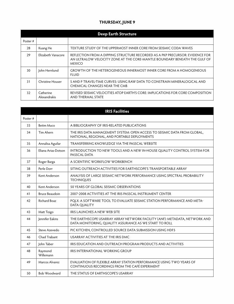
thurSdAy, June 9
deep earth Structure
Poster#
28 KuangHe TEXTURESTUDYOFTHEUPPERMOSTINNERCOREFROMSEISMICCODAWAVES
29 ElizabethVanacore REFLECTIONFROMADIPPINGSTRUCTURERECORDEDASAPKPPRECURSOR:EVIDENCEFORANULTRALOWVELOCITYZONEATTHECORE-MANTLEBOUNDARYBENEATHTHEGULFOFMEXICO
30 JohnHernlund GROWTHOFTHEHETEROGENEOUSINNERMOSTINNERCOREFROMAHOMOGENEOUSFLUID
31 ChristineHouser SANDPTRAVEL-TIMECURVES:USINGRAWDATATOCONSTRAINMINERALOGICALANDCHEMICALCHANGESNEARTHECMB
32 Catherine Alexandrakis
REVISEDSEISMICVELOCITIESATOPEARTH’SCORE:IMPLICATIONSFORCORECOMPOSITIONANDTHERMALSTATE
IrIS Facilities
Poster#
33 BetimMuco ABIBLIOGRAPHYOFIRIS-RELATEDPUBLICATIONS
34 TimAhern THEIRISDATAMANAGEMENTSYSTEM:OPENACCESSTOSEISMICDATAFROMGLOBAL,NATIONAL,REGIONAL,ANDPORTABLEDEPLOYMENTS
35 AnnalisaAguilar TRANSFERRINGKNOWLEDGEVIATHEPASSCALWEBSITE
36 ElianaArias-Dotson INTRODUCTIONTONEWTOOLSANDANEWIN-HOUSEqUALITYCONTROLSYSTEMFORPASSCALDATA
37 RogerBarga ASCIENTIFICWORKFLOWWORKBENCH
38 PerleDorr SITINGOUTREACHACTIVITIESFOREARTHSCOPE’STRANSPORTABLEARRAY
39 KentAnderson ANALYSISOFLARGESEISMICNETWORKPERFORMANCEUSINGSPECTRALPROBABILITYTECHNIqUES
40 KentAnderson 50YEARSOFGLOBALSEISMICOBSERVATIONS
41 BruceBeaudoin 2007-2008ACTIVITIESATTHEIRISPASSCALINSTRUMENTCENTER
42 RichardBoaz PqLX:ASOFTWARETOOLTOEVALUATESEISMICSTATIONPERFORMANCEANDMETA-DATAqUALITY
43 MattToigo IRISLAUNCHESANEWWEBSITE
44 JenniferEakins THEEARTHSCOPEUSARRAYARRAYNETWORKFACILITY(ANF):METADATA,NETWORKANDDATAMONITORING,qUALITYASSURANCEASWESTARTTOROLL
45 SteveAzevedo PICKITCHEN,CONTROLLEDSOURCEDATASUBMISSIONUSINGHDF5
46 ChadTrabant USARRAYACTIVITIESATTHEIRISDMC
47 JohnTaber IRISEDUCATIONANDOUTREACHPROGRAMPRODUCTSANDACTIVITIES
48 RaymondWillemann
IRISINTERNATIONALWORKINGGROUP
49 MarcosAlvarez EVALUATIONOFFLEXIBLEARRAYSTATIONPERFORMANCEUSINGTWOYEARSOFCONTINUOUSRECORDINGSFROMTHECAFéEXPERIMENT
50 BobWoodward THESTATUSOFEARTHSCOPE’SUSARRAY

Seismology, geodesy, and Ice dynamics in Polar regions
Poster#
1 MasakiKanao BROADBANDARRAYDEPLOYMENTSANDCRUST—MANTLESTRUCTUREAROUNDTHELüTZOW-HOLMBAY,EASTANTARCTICA
2 MasakiKanao BROADBANDSEISMICDEPLOYMENTSINEASTANTARCTICA:IPYCONTRIBUTIONTOUNDERSTANDINGTHEEARTH’SDEEPINTERIOR
3 Yusuke Usui SHEARWAVESPLITTINGBENEATHLüTZOW-HOLMBAYREGION,EASTANTARCTICAANDSRILANKA
4 TimParker DESIGNANDIMPLEMENTATIONOFCOLD-HARDENEDSEISMICSTATIONS
5 MarvinSpeece OVER-SEA-ICESEISMICREFLECTIONSURVEYSINANTARCTICAUSINGAGIAIRGUNANDASNOWSTREAMER
6 RichardAster CLASHOFTHEICEBERGS
7 PaulWinberry MICROSEISMICANDGEODETICOBSERVATIONSOFICESHEETDYNAMICS
8 MoiraPyle AMBIENTNOISERAYLEIGHWAVEGROUPVELOCITIESINANTARCTICAFROMALARGESCALEBROADBANDARRAY
9 Douglas Wiens TELESEISMICLONG-PERIODRADIATIONFROMMW7.0STICK-SLIPMOTIONOFTHEWHILLANSICESTREAM,WESTANTARCTICA
transportable Array/uSArray: transformative Science, technology, and culture
Poster#
121 Fan-ChiLin CONSTRUCTINGTHERAYLEIGHWAVEPHASESPEEDTRAVELTIMESURFACEINWESTERNUSUSINGTHEEARTHSCOPE/TA:APPLICATIONTOEIKONALTOMOGRAPHYANDEMPIRICALFINITEFREqUENCYSENSITIVITYKERNELS
122 KrisPankow INTEGRATIONOFEARTHSCOPETRANSPORTABLEARRAYSTATIONSINTOTHEUTAHREGIONALSEISMICNETWORK
123 DavidEaton SNOWPLOWTECTONICS:POST2.1GALITHOSPHERICEVOLUTIONOFTHEHUDSONBAYREGION
124 YingjieYang AMBIENTSEISMICNOISEANDTELESEISMICTOMOGRAPHYINTHEWESTERNUSA: HIGH-RESOLUTION3-DIMAGESOFTHECRUSTANDUPPERMANTLEFROMEARTHSCOPE/USARRAY
125 MorganMoschetti CRUSTALSHEAR-WAVEVELOCITYSTRUCTUREANDRADIALANISOTROPYBENEATHTHEWESTERNUNITEDSTATESFROMAMBIENTNOISEMEASUREMENTS
126 PrasantaPatro REGIONALCONDUCTIVITYSTRUCTUREOFCASCADIA:PRELIMINARYRESULTSFROM3DINVERSIONOFUSARRAYTRANSPORTABLEARRAYMAGNETOTELLURICDATA
127 NicholasSchmerr IMAGINGMANTLEDISCONTINUITIESBENEATHTHEJUANDEFUCAANDPACIFICPLATES
128 HuaiyuYuan 3-DISOTROPICANDANISOTROPICS-VELOCITYSTRUCTUREINNORTHAMERICA
129 ZhenXu BOOTSTRAPANALYSISONSURFACEWAVEDISPERSIONANDTOMOGRAPHYDERIVEDFROMAMBIENTNOISECROSS-CORRELATION
130 John West GEOPHYSICALDETECTIONOFLITHOSPHERICDELAMINATIONBENEATHTHECENTRALGREATBASIN,UNITEDSTATES
131 AndyFrassetto DETECTINGDELAMINATION?RECEIVERFUNCTIONSANDREGIONALWAVEFORMSFROMTHECENTRALANDNORTHERNSIERRANEVADA
132 YongKeunHwang SPATIALVARIATIONSOFATTENUATIONINTHEMANTLEBENEATHNORTHAMERICAFROMPWAVESPECTRALRATIOS

133 ScottPhillips MAPPINGLGqANDANISOTROPYUSINGTHEUSARRAY
134 MatthewFouch NEWCONSTRAINTSONMANTLESEISMICSTRUCTUREBENEATHTHENORTHWESTERNUNITEDSTATES
135 DanaPiwinski SEISMICINSTRUMENTSITINGUSINGGEOSPATIALTECHNOLOGY
136 JoshStachnik WAVEFIELDIMAGINGOFTHETRANSITIONZONEACROSSUSARRAY
137 PaulBodin FEEDINGTHE(DATA)NEED:RETAININGUSARRAYTASTATIONSINTHEPACIFICNORTHWEST
138 JochenBraunmiller THEMAUPIN,OREGONEARTHqUAKESWARMOF2007-2008

FrIdAy, June 9
Breaking the earthquake mold: episodic tremor and Slip
Poster#
10 JeanElkhoury PERMEABILITYENHANCEMENTBYDYNAMICSTRESSFIELDS
11 MichaelBrudzinski DANCINGWITHTHEPLATES:WATCHINGFAULTSSHIMMYANDSHAKE
12 John Vidale WHATDOESTREMORREALLYLOOKLIKE?INITIALRESULTSFROMAN80-ELEMENTARRAY
13 JustinRubinstein DYNAMICTRIGGERINGOFNON-VOLCANICTREMOREARTHqUAKESANDETSONVANCOUVERISLAND
14 Jonathan Lees WAVEFORMMODELINGOFSANTIAGUITOVOLCANOEXPLOSIONS
15 AnaAguiar MOMENTRATEDURINGCASCADIATREMORCONSTRAINEDBYGPS
16 AaronWech WASHINGTONTREMORLOCATIONS
17 MarioLaRocca CASCADIATREMORDEPTHSCONSTRAINEDBYSMINUSPTIMES
18 Justin Sweet LOW-FREqUENCYEARTHqUAKESINCASCADIA
19 DevinBoyarko SPATIALPATTERNSOFNONVOLCANICTREMORSOURCELOCATIONSALONGTHECASCADIASUBDUCTIONZONE
20 HectorHinojosa-Prieto
SPATIALANDTEMPORALPATTERNSOFNON-VOLCANICTREMORSOURCELOCATIONSALONGTHEOAXACANSEGMENTOFTHEMEXICANSUBDUCTIONZONE
21 AlejandroGallego TIDALCONSTITUENTSINNONVOLCANICSEISMICTREMORACTIVITYATTHECHILETRIPLEJUNCTION
22 David Shelly REPEATINGNATUREANDRELATIVELOCATIONOFSANANDREASFAULTTREMORSNEARCHOLAME,CA
23 Taka’akiTaira DYNAMICALLY-INDUCEDWEAKENINGOFTHESANANDREASFAULTBYTHE2004SUMATRA-ANDAMANEARTHqUAKE
24 AbhijitGhosh NON-VOLCANICTREMORATSANANDREASFAULTNEARPARKFIELDTRIGGEREDBYTHEGREATSUMATRAEARTHqUAKE,2004
25 PascalAudet SEISMICEVIDENCEFOROVERPRESSUREDSUBDUCTEDOCEANICCRUST
26 AurelieGuilhem INFLUENCEOFLARGEEARTHqUAKESONTHENONVOLCANICTREMORACTIVITYINTHEPARKFIELD-CHOLAMEREGION,CA
27 HeidiHouston SCALINGOFTHETREMORSOURCE
Synergy in Seismic event monitoring and research
Poster#
87 HelenaBuurman SEISMICPRECURSORSTOEXPLOSIVEERUPTIONSDURINGTHE2006ERUPTIONOFAUGUSTINEVOLCANO,ALASKA
88 ChunquanWu NON-LINEARITYANDTEMPORALCHANGESOFFAULTZONESITERESPONSEASSOCIATEDWITHSTRONGGROUNDMOTION
89 ValaHjörleifsdóttir EARTHqUAKESOURCEMODELINGUSINGTIME-REVERSALORADJOINTMETHODS
90 ElizabethCochran THEqUAKECATCHERNETWORK:CAPTURINGEARTHqUAKESUSINGDISTRIBUTEDCOMPUTING
91 AshleyShuler ANOMALOUSEARTHqUAKESASSOCIATEDWITHNYIRAGONGOVOLCANO:OBSERVATIONSANDPOTENTIALMECHANISMS
92 MattGardine TOWARDSTHEDEEPSEISMICSTRUCTUREOFCOLIMAVOLCANO,MEXICO

93 SeanFord RAPIDSOURCETYPEANDPARAMETERSOFTHEWELLS,NVANDCRANDALLCANYONMINE,UTEVENTSUSINGTHEUSARRAY
94 SheilaPeacock PRESUMEDMININGBLASTINWYOMINGASTESTOFTESTBANTREATYSEISMICMONITORINGSYSTEM
95 AlexNikulin AHIGHVELOCITYLAYERATDEPTHBENEATHBEZYMYANNIIVOLCANO,APOSSIBLESOURCEOFSEISMICITY?
96 GerrySimila MICROSEISMICITYANDTHETECTONICSETTINGOFTHESANJUANISLANDS,WASHINGTON
97 NatalieBalfour MAPPINGFAULTSANDSTUDYINGVOLCANOES:APPLICATIONSOFDOUBLE-DIFFERENCERELOCATIONSINBRITISHCOLUMBIA
98 FelixWaldhauser AREAL-TIMEPROCEDUREFORDOUBLE-DIFFERENCEEVENTLOCATION:PERFORMANCEEVALUATIONINNORTHERNCALIFORNIA
99 DanielMcNamara CLIMATEMONITORINGWITHTHEGSN
100 GavinHayes DEVELOPINGFRAMEWORKTOCONSTRAINTHEGEOMETRYOFTHESEISMICRUPTUREPLANEINSUBDUCTIONZONESAPRIORI
101 HongfengYang DETERMINATIONOFFAULTPLANEANDRUPTUREDIRECTIVITYOFTHEAPRIL2008M5.2MOUNTCARMELEARTHqUAKE,ILLINOIS,USINGDOUBLEDIFFERENCERELOCATIONANDSOURCETIMEFUNCTIONESTIMATIONTECHNIqUES
102 AlisonBird JANUARY2008REVERE-DELLWOOD-WILSONFAULTEARTHqUAKESEqUENCEOFFSHOREBRITISHCOLUMBIA
103 PhilMaechling ACCELERATINGSCECSEISMICHAZARDRESEARCHTHROUGHTHEUSEOFHIGHPERFORMANCECOMPUTINGONTHEPETASHAPROJECT
104 EgillHauksson APPLYINGWAVEFORMRELOCATEDBACKGROUNDSEISMICITYTOIMAGELATEqUATERNARYFAULTZONESINSOUTHERNCALIFORNIA
105 PaulDavis NEXTGENERATIONPORTABLEDASWITHWIRELESSCAPABILITY
106 ChunquanWu SYSTEMATICANALYSISTEMPORALCHANGESOFSITERESPONSEASSOCIATEDWITHSTRONGGROUNDMOTIONINJAPAN
107 AlexanderHutko BACK-PROJECTIONOFTELESEISMICP-WAVESANDPOINT-SPREADFUNCTIONDECONVOLUTIONFORIMAGINGEARTHqUAKEFINITE-SOURCERUPTUREPROCESSES
108 ShengjiWei REGIONALWAVEPROPAGATIONBENEATHWESTERNUS
109 Sergey Senyukov PREDICTINGEXPLOSIVEERUPTIONSATBEZYMIANNYVOLCANO,KAMCHATKARUSSIA
110 Dima Droznin NEWRELEASEOFDIMAS-2008:DISPLAY,INTERACTIVEMANIPULATION&ANALYSISOFSEISMOGRAMS
111 MichaelWest SEISMICINVESTIGATIONSATBEZYMIANNYVOLCANO(KAMCHATKA,RUSSIA)THROUGHTHENSFPIREPROGRAM
112 GregoryWaite LOCALEARTHqUAKEVPTOMOGRAPHYOFMOUNTST.HELENSUSINGDATAFROMPNSNPERMANENTANDIRIS-PASSCALTEMPORARYDEPLOYMENTS
113 MichaelLandes WEIGHINGEARTHqUAKESWAVESWITHHIGH-PRECISIONSCALES


2008 IRIS Workshop
Participants
geoff AbersLamont-Doherty Earth ObservatoryColumbia University61 Route 9WPalisades, NY 10964 [email protected]
david AbtBrown University324 Brook Street, Box 1846Providence, RI 02912 [email protected]
Annalisa AguilarPASSCALPO Box 40057Albuquerque, NM 87196 [email protected]
tim AhernIRIS1408 NE 45th Street, Suite 201Seattle, WA 98105 [email protected]
richard AllenEarth & Planetary ScienceUniversity of California, Berkeley307 McCone HallBerkeley, CA 94720 [email protected]
marcos AlvarezIRIS100 East RoadNew Mexico TechSocorro, NM 87801 USA575-835 [email protected]
charles AmmonPennsylvania State University440 Deike BuildingUniversity Park, PA 16802 [email protected]
Sridhar AnandakrishnanPennsylvania State University442 Deike BuildingUniversity Park, PA 16802 [email protected]
kent AndersonIRIS30 McLaughlin LaneSandia Park, NM 87047 [email protected]
rasool AnooshehpoorUniversity of Nevada Reno1664 N. Virginia StreetReno, NV 89557 [email protected]
david ApplegateU.S. Geological Survey 12201 Sunrise Valley DriveReston, VA 20192 [email protected]
Biniam AsmeromUniversity of Memphis3890 Central AvenueMemphis, TN 38152 [email protected]
richard AsterNew Mexico Tech801 Leroy PlaceSocorro, NM 87801 [email protected]
Pascal AudetUniversity of British Columbia6339 Stores RoadVancouver, BC V6T [email protected]
Steve AzevedoIRIS/PASSCAL PICNew Mexico Tech100 East RoadSocorro, NM 87801 [email protected]
Sandra AzevedoNMT-TA Coordinating Office100 East RoadSocorro, NM 87801 [email protected]
richard BaldwinNatural Resources Canada9860 W. SaanichSidney, BC VAL [email protected]
natalie BalfourUniversity of Victoria3561 QuadraVictoria, BC V8X [email protected]

roger BargaMicrosoft ResearchOne Microsoft WayRedmond, WA 98052 [email protected]
noel BarstowIRIS/PASSCAL Instrument Center1205 Flor del ValleSocorro, NM 87801 [email protected]
tim BartonGeoscience AustraliaGPO Box 378 Canberra ACT [email protected]
Bruce BeaudoinIRIS PASSCAL100 East RoadNew Mexico TechSocorro, NM 87801 [email protected]
Susan BeckDepartment of GeosciencesUniversity of ArizonaGould Simpson BuildingTucson, AZ 85721 [email protected]
manahloh BelachewUniversity of Rochester60 Crittenden Boulevard, # 331Rochester, NY 14620 [email protected]
gregory BerozaStanford University397 Panama MallStanford, CA 94305 [email protected]
glenn BiasiSeismological LaboratoryUniversity of Nevada RenoMS-174Reno, NV 89557 [email protected]
Susan BilekEarth and Environmental ScienceNew Mexico Tech801 Leroy PlaceSocorro, NM 87801 [email protected]
Alison BirdGeological Survey of Canada9860 W. SaanichSidney, BC VAL [email protected]
richard BoazBoaz ConsultancyAlter Bergweg 9Valwigerberg [email protected]
Paul BodinEarth & Space SciencesUniversity of WashingtonJohnson Hall 070Seattle, WA 98195 [email protected]
michael BostockThe University of British Columbia6339 Stores RoadVancouver, BC V6T [email protected]
devin BoyarkoMiami University114 Shideler HallOxford, OH 45056 [email protected]
Jochen BraunmillerEarthScope National OfficeOregon State University104 COAS Admin. Bldg.Corvallis, OR 97331 [email protected]
Justin BrownStanford University397 Panama MallStanford, CA 94305 [email protected]
michael BrudzinskiMiami University114 Shideler HallOxford, OH 45056 [email protected]
robert BusbyIRIS37 Haynes AvenueFalmouth, MA 02540 [email protected]
rhett ButlerIRIS1200 New York Avenue, NWSuite 800Washington, DC 20005 [email protected]
robert ButlerDepartment of PhysicsUniversity of Portland5000 N. Willamette BoulevardPortland, OR 97203 [email protected]
helena BuurmanGeophysical InstituteUniversity of Alaska Fairbanks903 Koyukuk DriveFairbanks, AK 99775 [email protected]
rick callenderIRIS Consortium1200 New York Avenue, NWSuite 800Washington, DC 20005202-682-2220
robert caseyIRIS DMC1408 NE 45th Street, Suite 201Seattle, WA 98105 [email protected]
mark chadwickGNS Science1 Fairway Drive, AvalonLower Hutt 05010New [email protected]
Sung-Joon changNorthwestern University1850 Campus DriveEvanston, IL 60208 [email protected]
min chenCaltech1200 E. California BoulevardMC 252-21Pasadena, CA 91125 [email protected]
chingwen chenUniversity of Houston2111 Holly Hall #706Houston, TX 77054 [email protected]
douglas christensenGeophysical Institute UAFUniversity of Alaska FairbanksP.O. Box 757320Fairbanks, AK 99775 [email protected]
risheng chuCaltech1200 E. California BoulevardPasadena, CA 91125 [email protected]
elizabeth cochranDepartment of Earth SciencesUniversity of California, RiversideRiverside, CA 92521 [email protected]
Ben colemanMoravian CollegeDepartment of Mathematics and
Computer Science1200 Main StreetBethlehem, PA [email protected]
John collinsWoods Hole Oceanographic
Institution360 Woods Hole RoadWoods Hole, MA 02543 [email protected]
katie cooperNational Science Foundation4201 Wilson BoulevardArlington, VA [email protected]
trilby coxUCSD-ANF1112 WaukeshaButte, MT 59701 [email protected]
catherine coxUniversity of Oklahoma1222 Wylie Road, #190Norman, OK 73072 [email protected]
ken creagerDepartment Earth and Space Sci.University of WashingtonBox 351310Seattle, WA 98195 [email protected]
colleen daltonDepartment of Earth SciencesBoston University675 Commonwealth AvenueBoston, MA 02215 [email protected]
Paul davisUCLAHilgard AvenueLos Angeles, CA 90095 [email protected]
Perle dorrIRIS Consortium1200 New York Avenue, NWSuite 800Washington, DC 20005 [email protected]
eliana A. dotsonIRIS/PASSCAL100 East RoadSocorro, NM 87801 [email protected]
douglas dregerBerkeley Seismological LaboratoryUniversity of California Berkeley281 McCone HallBerkeley, CA 94720 [email protected]

dima drozninKamchatka Branch of Geophysical
SurveysPiip [email protected]
Thomas duffyDepartment of GeosciencesPrinceton UniversityPrinceton, NJ 08544 [email protected]
Adam dziewonskiHarvard University184 Old Littleton RoadHarvard, MA 01451 [email protected]
Jennifer eakinsUCSD-ANFMC-0225, 9500 Gilman DriveLa Jolla, CA 92093 [email protected]
Paul earleU.S. Geological Survey MS 966, Box 25046, DFCDenver, CO 80225 USA303-517 [email protected]
david eatonDepartment of GeoscienceUniversity of Calgary2500 University Drive NWCalgary, Alberta T2N [email protected]
göran ekströmLamont-Doherty Earth ObservatoryColumbia University61 Route 9WPalisades, NY 10964 [email protected]
Jean elkhouryUniversity of California, Santa Cruz1156 Hight StreetSanta Cruz, CA 95060 [email protected]
denise elvrumNMT-TA Coordinating Office100 East RoadSocorro, NM 87801 [email protected]
dan FayMicrosoft Research1 Microsoft WayRedmond, WA [email protected]
kevin FenaughtyGNS Science1 Fairway Drive, AvalonLower Hutt 05010New [email protected]
Aaron FerrisWeston Geophysical181 Bedford Street, Suite 1Lexington, MA 02420 [email protected]
Sean FordBerkeley Seismological Laboratory215 McCone Hall #4760 Berkeley, CA 94720 [email protected]
donald ForsythDepartment of Geol. Sci.Brown UniversityBox 1846Providence, RI 02912 [email protected]
Anna FosterLamont-Doherty Earth ObservatoryColumbia University526 W 112th Street, Apt. 62New York, NY 10025 [email protected]
matthew FouchSchool of Earth and Space ExplorationArizona State UniversityPO Box 871404Tempe, AZ 85287 [email protected]
Jim FowlerIRIS/PASSCAL701 BufordSocorro, NM 87801 [email protected]
Andrew FrassettoDepartment of GeosciencesUniversity of Arizona1040 E 4th StreetTucson, AZ 85721 [email protected]
gary FuisU.S. Geological Survey 345 Middlefield RoadMenlo Park, CA 94020 [email protected]
kevin FurlongDepartment GeosciencesPennsylvania State University542 Deike Building University Park, PA 16802 [email protected]
James gahertyLamont-Doherty Earth ObservatoryColumbia University61 Route 9WPalisades, NY 10964 [email protected]

Alejandro gallegoUniversity of Florida2601 SW Archer Road, Apt. 252Gainesville, FL 32608 [email protected]
haiying gaoUniversity of Oregon2250 Patterson Street, #98Eugene, OR 97405 [email protected]
matt gardineUniversity of Alaska Fairbanks903 Koyukuk DriveFairbanks, AK 99775 [email protected]
ed garneroSchool of Earth and Space ExplorationArizona State UniversityTempe, AZ 85287 [email protected]
Lind geeAlbuquerque Seismological LabU.S. Geological Survey PO Box 82010Albuquerque, NM 87198 [email protected]
Joseph GerencherDepartment of Physics and Earth
ScienceMoravian College1200 Main StreetBethlehem, PA 18018 [email protected]
Abhijit ghoshUniversity of WashingtonJohnson Hall 070, Box 3513104000 15th Avenue NESeattle, WA 98195 [email protected]
tea godoladzeInstitute of Geophysics1 Alexidze [email protected]
Steven goldenCarnegie Institution of Washington5241 Broad Branch Road, NWWashington, DC 20015 [email protected]
Patricia griegoIRIS/PASSCAL New Mexico Tech100 East RoadSocorro, NM 87801 [email protected]
yu guDepartment of PhysicsUniversity of AlbertaEdmonton, AB [email protected]
Aurelie guilhemBerkeley Seismological LaboratoryUniversity of California225 McCone HallBerkeley, CA 94704 [email protected]
katrin hafnerIRIS2073 North Fork DriveLafayette, CO 80026 [email protected]
Alexander hannaCal State Northridge19837 Kittridge Street Canoga Park, CA 91306 [email protected]
roger hansenUniversity of Alaska1370 ViewpointFairbanks, AK 99709 [email protected]
Steven harderDepartment of Geological SciencesUniversity of Texas at El Paso500 W. University AvenueEl Paso, TX 79968 [email protected]
danny harveyBoulder Real Time Technologies2045 Broadway Street, Suite 400Boulder, CO 80302 [email protected]
egill haukssonCalifornia Institute of Technology1200 East California BoulevardPasadena, CA 91125 [email protected]
ernest hauserWright State University3640 Colonel Glenn HwyDayton, OH 45435 [email protected]
robert hawmanUniversity of Georgia210 Field StreetAthens, GA 30602 [email protected]
gavin hayesU.S. Geological Survey NEICPO Box 25046, MS966Denver, CO 80225 [email protected]

chris haywardSouthern Methodist University3225 Daniel AvenueDallas, TX 75275 [email protected]
kuang heUniversity of Connecticut2152 Hillside Road U3046 Storrs, CT 06269 [email protected]
don helmbergerCaltech1987 Braeburn RoadAltadena, CA 91001 [email protected]
John hernlundUniversity of British Columbia6339 Stores RoadVancouver, [email protected]
hector hinojosaMiami University114 Shideler Hall Oxford, OH 45056 [email protected]
naoshi hirataEarthquake Research InstituteUniversity of TokyoYayoi, Bunkyo-ku Tokyo [email protected]
vala hjörleifsdóttirLamont-Doherty Earth ObservatoryColumbia University61 Route 9W, PO BOX 1000Palisades, NY 10964 [email protected]
christine houserEarth and Planetary SciencesUniversity of California, Santa Cruz1156 High StreetSanta Cruz, CA 95064 [email protected]
heidi houstonUniversity of WashingtonJohnson Hall 0704000 15th Avenue NESeattle, WA [email protected]
eugene humphreysDepartment of Geological SciencesUniversity of OregonEugene, OR 07403 [email protected]
Alexander hutkoU.S. Geological Survey MS 966 Box 25046, DFCDenver, CO 80225 [email protected]
yong keun hwangUniversity of Michigan2222 Fuller Ct., Apt 314AAnn Arbor, MI 48105 [email protected]
Satoshi IdeDepartment of Earth and Planetary
ScienceUniversity of Tokyo7-3-1 Hongo BunkyoTokyo [email protected]
miaki IshiiHarvard University20 Oxford StreetCambridge, MA 02138 [email protected]
david JamesCarnegie Institution/DTM5241 Broad Branch Road, NWWashington, DC 20015 [email protected]
kevin JensenUniversity of Utah135 South 1460 East, Room 703Salt Lake City, UT 84112 [email protected]
tianxia JiaLamont-Doherty Earth ObservatoryColumbia University503 West 121st Street 33ANew York, NY 10027 [email protected]
un JoeIRIS1408 NE 45th Street, Suite 201Seattle, WA 98105 [email protected]
Leonard JohnsonNational Science Foundation4201 Wilson Boulevard, Room 785Arlington, VA 22230 [email protected]
Jenda JohnsonIRIS/USArray1924 NE 47th AvenuePortland, OR 97213 [email protected]
Alan kafkaWeston Observatory/Boston College381 Concord RoadWeston, MA 02493 [email protected]

hiroo kanamoriCalifornia Institute of Technology1200 E. California BoulevardMC 252-21Pasadena, CA 91125 [email protected]
masaki kanaoNational Institute of Polar Research1-9-10 Itabashi-kuToyko AL [email protected]
randy kellerSchool of Geology and GeophysicsUniversity of Oklahoma100 E. BoydNorman, OK 73019 [email protected]
Louise kelloggUniversity of California, DavisDepartment of Geology1 Shields AvenueDavis, CA 95616 [email protected]
Ahyi kimBerkeley Seismological LaboratoryUniversity of California Berkeley289 McCone HallBerkeley, CA 94720 [email protected]
Jim knappUniversity of South Carolina701 Sumter StreetColumbia, SC [email protected]
minoo kosarianUCLA595 Charles Young Drive East Los Angeles, CA 90095 [email protected]
oliver kreylosUniversity of California Davis2143 Academic Surge BldgOne Shields AvenueDavis, CA 95616 [email protected]
glenn kroegerTrinity UniversityOne Trinity PlaceSan Antonio, TX 78212 [email protected]
hao kuo-chenSUNY at Binghamton321 Main Street, Apartment 2Binghamton, NY 13905 [email protected]
michael LandesIndiana University1001 East 10th StreetBloomington, IN 47405 USA812-856 [email protected]
chris LaughbonIRIS1408 NE 45th Street Seattle, WA 98105 [email protected]
Jesse LawrenceStanford University397 Panama MallMitchell Bldg Room 360Stanford, CA 94305 [email protected]
Thorne LayEarth and Planetary SciencesUniversity of California, Santa CruzEarth and Marine Sci. Bldg.Santa Cruz, CA 95064 [email protected]
en-Jui LeeSUNY Binghamton16 Grand Boulevard Binghamton, NY 13905 [email protected]
Jonathan LeesUniversity of North CarolinaCB 3315Chapel Hill, NC 27599 [email protected]
gerardo Leon SotoNew Mexico State University1120 Plain Street 1ALas Cruces, NM 88001 [email protected]
Arthur Lerner-LamLamont-Doherty Earth ObservatoryColumbia University61 Route 9WPalisades, NY 10964 [email protected]
Jim LewkowiczWeston Geophysical Corp.181 Bedford Street, Suite 1Lexington, MA 02420 [email protected]
robert LiebermannCOMPRESESS Building, Room 167Stony Brook, NY 11794 [email protected]
robert J. LillieDepartment of GeosciencesOregon State UniversityWilkinson 104Corvallis, OR 97331 [email protected]

Fan-chi LinUniversity of Colorado at Boulder1300 30th Street, Apt D5-14Boulder, CO 80303 [email protected]
Leslie LinnIRIS1200 New York Avenue, NWSuite 800Washington, DC 20005 [email protected]
tim LongGeorgia Institute of Technology747 Mulligan Way #20409 Jasper, GA 30143 [email protected]
victoria (Shuqin) maGeosciences DepartmentUniversity of Houston236 Science and Research, Building 1Houston, TX 77204 [email protected]
Jonathan maccarthyNew Mexico Institute of Mining and
Technology801 Leroy PlaceSocorro, NM 87801 [email protected]
Stephen maloneUniversity of WashingtonESS Box 351310Seattle, WA 98185 [email protected]
Jeff mcguireDept. of Geology and GeophysicsWoods Hole Oceanographic
InstitutionMS24 Woods Hole, MA 02543 [email protected]
chris mcmillanMiami University114 Shideler Hall Oxford, OH 45056 [email protected]
daniel mcnamaraU.S. Geological Survey 1711 Illinois StreetGolden, CO 80401 [email protected]
tim melbourneCentral Washington University400 E University Way Ellensburg, WA 98926 [email protected]
robert mellorsSan Diego State University5500 Campanile DriveSan Diego, CA 92182 [email protected]
Jean-Philippe mercierUniversity of British Columbia2233 West 2nd Avenue, #205Vancouver, BC V6K [email protected]
dylan mikesellBoise State University1910 University DriveBoise, ID 83725 [email protected]
m. meghan millerUNAVCO6350 Nautilus DriveBoulder, CO [email protected]
meghan S. millerRice University/UBC6100 Main Street, MS 126Houston, TX 77005 [email protected]
Brian mitchellSaint Louis UniversityDepartment of Earth and Atmospheric
Sciences3842 Lindell BoulevardSt. Louis, MO 63108 [email protected]
charles monfortMonfort Lewis LLC517 2nd Street NEWashington, DC 20002 [email protected]
Walter mooneyU.S. Geological Survey 345 Middefield Road, MS 977Menlo Park, CA 94025 [email protected]
Seth moranCascades Volcano ObservatoryU.S. Geological Survey 1300 SE Cardinal CtVancouver, WA 98607 [email protected]
Igor morozovUniversity of Saskatchewan114 Science PlaceSaskatoon, SK [email protected]
morgan moschettiUniversity of Colorado at BoulderCampus Box 390Boulder, CO 80309 [email protected]

taimi mulderUCSD-ANFIGPP 0225San Diego, CA [email protected]
mark murrayEarth & Envir Sci DepartmentNew Mexico Tech801 Leroy PlaceSocorro, NM 87801 [email protected]
meredith nettlesLamont-Doherty Earth ObservatoryColumbia University61 Route 9WPalisades, NY 10964 [email protected]
douglas neuhauserSeismological LaboratoryUniversity of California, Berkeley215 McCone Hall #4760Berkeley, CA 94720 [email protected]
Susan newmanSeismological Society of America201 Plaza Prof BuildingEl Cerrito, CA 94530 [email protected]
James niDepartment of Physics New Mexico State UniversityLas Cruces, NM 88003 [email protected]
tina niemiDepartment of GeosciencesUniversity of Missouri-Kansas City5100 Rockhill RoadKansas City, MO 64110 USA816 [email protected]
Alex nikulinRutgers GeoSciencesRutgers University610 Taylor RoadPiscataway, NJ 08854 [email protected]
david okayaDepartment Earth SciencesUniversity of Southern CaliforniaLos Angeles, CA 90089 [email protected]
kristine PankowSeismograph StationsUniversity of Utah 135 South 1460 East, Room 705Salt Lake City, UT 84112 [email protected]
Jeffrey ParkYale University32 Mountain View TerraceNorth Haven, CT 06473 [email protected]
yongcheol ParkThe National Institute of
Meteorological Research45 Gisangcheong-gil Dongjak-guSeoul 156-720Republic of Korea+82 2 [email protected]
Paul PassmoreRefraction Technology Inc.1600 Tenth Street, Suite APlano, TX 75074 [email protected]
Bruce PaulyDigital Technology Associates1330-A Galaxy WayConcord, CA 94520 [email protected]
gary PavlisIndiana UniversityDepartment of Geological Sciences1001 East 10th StreetBloomington, IN 47405 [email protected]
Sheila PeacockBlacknestBrimptonReading Berkshire RG7 4RSUK+44 1189 [email protected]
Scott PhillipsLos Alamos National LaboratoryMS F659Los Alamos, NM 87545 [email protected]
dana PiwinskiIAGT199 Franklin Street, Suite 300Auburn, NY 13021 [email protected]
moira PyleWashington University in St. LouisOne Brookings DriveCampus Box 1169St. Louis, MO 63130 [email protected]
daniel quinlanBoulder Real Time Technologies2045 Broadway, Suite 400Boulder, CO 80302 [email protected]
kelly reevesIRIS1200 New York Avenue, NWSuite 800Washington, DC 20005 [email protected]

robin reichlinNational Science Foundation4201 Wilson BoulevardArlington, VA 22203 [email protected]
Jeroen ritsemaUniversity of Michigan2534 CC Little Ann Arbor, MI 48109 [email protected]
michael ritzwollerDepartment of PhysicsUniversity of Colorado at BoulderBoulder, CO 80309 [email protected]
Barbara romanowiczBerkeley Seismological LaboratoryUniversity of California, Berkeley219 McCone HallBerkeley, CA 94720 [email protected]
Stephane rondenayMIT77 Massachusetts Avenue, 54-618Cambridge, MA 02139 [email protected]
Justin rubinsteinU.S. Geological Survey Menlo Park345 Middlefield Road/MS-977Menlo Park, CA 94025 [email protected]
ray russoUniversity of FloridaP.O. Box 112120241 Williamson HallGainesville, FL 32611 [email protected]
teresa SaavedraIRIS Consortium1200 New York Avenue, NWSuite 800Washington, DC 20005 [email protected]
victor SardinaPacific Tsunami Warning Center91-270 Fort Weaver Road Ewa Beach, HI 96706 [email protected]
Allan SauterNMT-TA Coordinating Office100 East Road Socorro, NM 87801 [email protected]
Andrew SchaefferUniversity of British Columbia6339 Stores RoadVancouver, [email protected]
Brandon SchmandtUniversity of Oregon1272 University of Oregon Eugene, OR 97403 [email protected]
nicholas SchmerrArizona State UniversityBox 871404 Tempe, AZ 85287 [email protected]
Frederick SchultAir Force Research LabAFRL/RVBYE29 Randolph RoadHanscom AFB, MA 01731 [email protected]
Sergey SenyukovKamchatka Branch of Geophysical
SurveysPiip [email protected]
kaye ShedlockNational Science Foundation4201 Wilson Boulevard, Room 785Arlington, VA 22230 [email protected]
david ShellyU.S. Geological Survey Menlo ParkUSGS WR - GD345 Middlefield RoadMenlo Park, CA 94025 [email protected]
Ashley ShulerLamont-Doherty Earth ObservatoryColumbia University61 Route 9WPalisades, NY 10964 [email protected]
Paul SilverDepartment of Terrestrial MagnetismCarnegie Institution of Washington5241 Broad Branch Road, NWWashington, DC 20015 [email protected]
gerry SimilaDepartment GeologyCalifornia State University, Northridge18111 Nordhoff StreetNorthridge, CA 91330 [email protected]

david SimpsonIRIS1200 New York Avenue, NWSuite 800Washington, DC 20005 [email protected]
catherine SnelsonDepartment of Earth and
Environmental Science New Mexico Institute of Mining and
Technology801 Leroy PlaceSocorro, NM 87801 [email protected]
teh-ru SongCarnegie Institute of Washington5241 Broad Branch RoadWashington, DC 20015 [email protected]
marvin SpeeceMontana Tech of the University of
Montana1300 West Park StreetButte, MT 59701 [email protected]
neil SpriggsNanometrics250 Herzberg RoadKanata, [email protected]
Josh StachnikUniversity of Wyoming1000 E University AvenueLaramie, WY 82071 [email protected]
Joann StockCaltechSeismo Lab 252-211200 E California BoulevardPasadena, CA 91125 [email protected]
Brian StumpSouthern Methodist University1605 Pembroke LaneMcKinney, TX 75070 [email protected]
daoyuan SunCaltech1200 E. California BoulevardPasadena, CA 91125 [email protected]
Justin SweetUniversity of Washington620 N 34th Street, Apt 214Seattle, WA 98103 [email protected]
John taberIRIS1200 New York Avenue, NWSuite 800Washington, DC 20005 [email protected]
ugur teomanBogazici UniversityCengelkoyIstanbulTurkey90 216 516 332 [email protected]
glenn ThompsonAlaska Earthquake Information CenterKoyukuk DriveFairbanks, AK 99775 [email protected]
michael ThorneDepartment of Geology & GeophysicsUniversity of Utah135 South 1460 EastSalt Lake City, UT 84112 [email protected]
matt toigoIRIS1200 New York Avenue, NWSuite 800Washington, DC 20002 [email protected]
chad trabantIRIS - DMC1408 NE 45th StreetSeattle, WA 98105 [email protected]
Anne trehuOregon State UniversityCOAS Admin Bld 104Corvallis, OR 97331 [email protected]
Jeroen trompCalifornia Institute of Technology1200 E. California BoulevardMC 252-21Pasadena, CA 91125 [email protected]
yusuke usuiGeodynamics Research CenterEhime University2-5 Bunkyo-choMatsuyama [email protected]

Suzan van der LeeDepartment of Earth SciencesNorthwestern University1850 Campus DriveEvanston, IL 60208 [email protected]
elizabeth vanacoreRice University1410 Richmond Avenue, Apt #363Houston, TX 77006 [email protected]
Frank vernonInstitute of Geophysics and Planetary
PhysicsUniversity of California, San Diego9500 Gilman Drive, Mail Code 0225La Holla, CA 92093 [email protected]
John vidaleUniversity of Washington8726 NE 11th Street Bellevue, WA 98004 [email protected]
Lara WagnerUniversity of North Carolina at Chapel
Hill104 South Road, Campus Box 3315Chapel Hill, NC 27599 [email protected]
gregory WaiteMichigan TechGeological Sciences1400 Townsend DriveHoughton, MI 49931 [email protected]
Felix WaldhauserLamont-Doherty Earth Observatory Columbia University61 Route 9WPalisades, NY 10027 [email protected]
William WalterLawrence Livermore National
Laboratory7000 East AvenueLivermore, CA 94551 [email protected]
Phil WannamakerEnergy and Geoscience InstituteUniversity of Utah423 Wakara Way, Suite 300Salt Lake City, UT 84108 [email protected]
Aaron WechUniversity of Washington712 N. 49th StreetSeattle, WA [email protected]
dayanthie WeeraratneCalifornia State University Northridge 18111 NordhoffNorthridge, CA 91330 [email protected]
Shengji WeiSeismological LaboratoryCalifornia Institute of Technology1200 E. California BoulevardMS 252-21 So. Mudd BuildingPasadena, CA 91125 [email protected]
chester WeissVirginia Tech4044 Derring HallBlacksburg, VA [email protected]
John WestArizona State University3370 N. Hayden Road #123-179Scottsdale, AZ 85251 [email protected]
krista WestFreelancePO Box 80962 Fairbanks, AK 99708 [email protected]
michael WestUniversity Alaska Fairbanks/Alaska Volcano Observatory903 Koyukuk DriveGeophysical InstituteFairbanks, AK 99775 [email protected]
Laura WetzelEckerd College4200 54th Avenue SouthSaint Petersburg, FL 33711 [email protected]
James WhitcombNational Science Foundation4201 Wilson Boulevard, #785Arlington, VA 22230 [email protected]
douglas WiensWashington UniversityCampus Box 11691 Brookings DriveSt. Louis, MO 63130 [email protected]
raymond WillemannIRIS Consortium1200 New York Avenue, NWSuite 800Washington, DC 20005 [email protected]

mark WilliamsOregon State University104 COAS Admin Corvallis, OR 97331 [email protected]
Paul WinberryPennsylvania State University 441 Deike BuildingUniversity Park, PA 16802 [email protected]
Lindsay WoodIRIS1200 New York Avenue, NWSuite 800Washington, DC 20005 [email protected]
maryAnn WoodIRIS DMC1408 NE 45th Street, Suite 201Seattle, WA 98105 [email protected]
Bob WoodwardIRIS1200 New York Avenue, NWSuite 800Washington, DC 20005 [email protected]
rob WoolleyIRIS1200 New York Avenue, NWSuite 800Washington, DC 20005 [email protected]
Francis WuSUNY BinghamtonDepartment of Geol. Sci.Vestal Pkwy E.Binghamton, NY 13902 [email protected]
chunquan WuGeorgia Institute of Technology311 Ferst DriveES&T Room 2120Atlanta, GA 30332 [email protected]
michael WysessionDepartment of Earth and Atmospheric
SciencesWashington University in St. LouisCampus Box 11691 Brookings DriveSt. Louis, MO 63130 [email protected]
zhen XuUniversity of Illinois at Urbana-
Champaign245 NHB, 1301 W. Green StreetUrbana, IL 61801 [email protected]
yingjie yangUniversity of Colorado at Boulder1200 Colorado Avenue Boulder, CO 80309 [email protected]
hongfeng yangSaint Louis University3642 Lindell Boulevard Saint Louis, MO 63108 [email protected]
huaiyu yuanBerkeley Seismological LabUniversity of California, Berkeley215 McCone HallBerkeley, CA [email protected]
haijiang zhangEarth Atmospheric and Planetary
Sciences MIT54-1818 77 Massachusetts AvenueCambridge, MA 02139 [email protected]


2008 IRIS Workshop
Abstracts
BreAkIng the eArthquAke moLd: ePISodIc tremor And SLIP
AnaAguiar MOMENTRATEDURINGCASCADIATREMORCONSTRAINEDBYGPS ...........................................................................1
PascalAudet SEISMICEVIDENCEFOROVERPRESSUREDSUBDUCTEDOCEANICCRUST.....................................................................2
DevinBoyarko SPATIALPATTERNSOFNONVOLCANICTREMORSOURCELOCATIONSALONGTHECASCADIASUBDUCTIONZONE ...................................................................................................................................................................................3
MichaelBrudzinski DANCINGWITHTHEPLATES:WATCHINGFAULTSSHIMMYANDSHAKE......................................................................4
KenCreager EPISODICTREMORANDSLIPINCASCADIA ..................................................................................................................................5
JeanElkhoury PERMEABILITYENHANCEMENTBYDYNAMICSTRESSFIELDS ..............................................................................................6
AlejandroGallego TIDALCONSTITUENTSINNONVOLCANICSEISMICTREMORACTIVITYATTHE CHILETRIPLEJUNCTION ..........................................................................................................................................................................7
AbhijitGhosh NON-VOLCANICTREMORATSANANDREASFAULTNEARPARKFIELDTRIGGEREDBYTHE GREATSUMATRAEARTHqUAKE,2004 .............................................................................................................................................8
AurelieGuilhem INFLUENCEOFLARGEEARTHqUAKESONTHENONVOLCANICTREMORACTIVITY INTHEPARKFIELD-CHOLAMEREGION,CA ....................................................................................................................................9
HectorHinojosa-Prieto SPATIALANDTEMPORALPATTERNSOFNON-VOLCANICTREMORSOURCELOCATIONS ALONGTHEOAXACANSEGMENTOFTHEMEXICANSUBDUCTIONZONE ............................................................. 10
HeidiHouston SCALINGOFTHETREMORSOURCE ............................................................................................................................................... 11
SatoshiIde EPISODICTREMORANDSLIPINJAPAN .........................................................................................................................................12
MarioLaRocca CASCADIATREMORDEPTHSCONSTRAINEDBYSMINUSPTIMES ............................................................................... 13
Jonathan Lees WAVEFORMMODELINGOFSANTIAGUITOVOLCANOEXPLOSIONS .......................................................................... 14
JustinRubinstein DYNAMICTRIGGERINGOFNON-VOLCANICTREMOREARTHqUAKESAND ETSONVANCOUVERISLAND ............................................................................................................................................................ 15
David Shelly REPEATINGNATUREANDRELATIVELOCATIONOFSANANDREASFAULTTREMORS NEARCHOLAME,CA ...............................................................................................................................................................................16
Justin Sweet LOW-FREqUENCYEARTHqUAKESINCASCADIA ................................................................................................................... 17
Taka’akiTaira DYNAMICALLY-INDUCEDWEAKENINGOFTHESANANDREASFAULTBYTHE 2004SUMATRA-ANDAMANEARTHqUAKE ................................................................................................................................18
John Vidale WHATDOESTREMORREALLYLOOKLIKE?INITIALRESULTSFROMAN80-ELEMENTARRAY ......................... 19
AaronWech WASHINGTONTREMORLOCATIONS ...........................................................................................................................................20

deeP eArth Structure
CatherineAlexandrakis REVISEDSEISMICVELOCITIESATOPEARTH’SCORE:IMPLICATIONSFORCORE COMPOSITIONANDTHERMALSTATE ..........................................................................................................................................21
KuangHe TEXTURESTUDYOFTHEUPPERMOSTINNERCOREFROMSEISMICCODAWAVES .............................................22
JohnHernlund GROWTHOFTHEHETEROGENEOUSINNERMOSTINNERCOREFROMAHOMOGENEOUSFLUID ............23
ChristineHouser SANDPTRAVEL-TIMECURVES:USINGRAWDATATOCONSTRAINMINERALOGICALAND CHEMICALCHANGESNEARTHECMB ...........................................................................................................................................24
ElizabethVanacore REFLECTIONFROMADIPPINGSTRUCTURERECORDEDASAPKPPRECURSOR:EVIDENCEFORANULTRALOWVELOCITYZONEATTHECORE-MANTLEBOUNDARYBENEATHTHEGULFOFMEXICO ........25
IrIS FAcILItIeS
TimAhern THEIRISDATAMANAGEMENTSYSTEM:OPENACCESSTOSEISMICDATAFROMGLOBAL, NATIONAL,REGIONAL,ANDPORTABLEDEPLOYMENTS .....................................................................................................26
AnnalisaAguilar TRANSFERRINGKNOWLEDGEVIATHEPASSCALWEBSITE .................................................................................................27
MarcosAlvarez EVALUATIONOFFLEXIBLEARRAYSTATIONPERFORMANCEUSINGTWOYEARSOF CONTINUOUSRECORDINGSFROMTHECAFéEXPERIMENT ............................................................................................28
KentAnderson 50YEARSOFGLOBALSEISMICOBSERVATIONS ........................................................................................................................29
KentAnderson ANALYSISOFLARGESEISMICNETWORKPERFORMANCEUSINGSPECTRAL PROBABILITYTECHNIqUES ................................................................................................................................................................. 30
ElianaArias-Dotson INTRODUCTIONTONEWTOOLSANDANEWIN-HOUSEqUALITYCONTROLSYSTEMFOR PASSCALDATA ............................................................................................................................................................................................ 31
SteveAzevedo PICKITCHEN,CONTROLLEDSOURCEDATASUBMISSIONUSINGHDF5 ......................................................................32
RogerBarga ASCIENTIFICWORKFLOWWORKBENCH .................................................................................................................................... 33
BruceBeaudoin 2007-2008ACTIVITIESATTHEIRISPASSCALINSTRUMENTCENTER ............................................................................ 34
RichardBoaz PqLX:ASOFTWARETOOLTOEVALUATESEISMICSTATIONPERFORMANCEAND META-DATAqUALITY ............................................................................................................................................................................. 35
PerleDorr SITINGOUTREACHACTIVITIESFOREARTHSCOPE’STRANSPORTABLEARRAY ......................................................36
JenniferEakins THEEARTHSCOPEUSARRAYARRAYNETWORKFACILITY(ANF):METADATA,NETWORK ANDDATAMONITORING,qUALITYASSURANCEASWESTARTTOROLL ............................................................... 37
BetimMuco ABIBLIOGRAPHYOFIRIS-RELATEDPUBLICATIONS ................................................................................................................38
JohnTaber IRISEDUCATIONANDOUTREACHPROGRAMPRODUCTSANDACTIVITIES .......................................................... 39
MattToigo IRISLAUNCHESANEWWEBSITE ..................................................................................................................................................... 40
ChadTrabant USARRAYACTIVITIESATTHEIRISDMC ........................................................................................................................................ 41
RaymondWillemann IRISINTERNATIONALWORKINGGROUP .....................................................................................................................................42
BobWoodward THESTATUSOFEARTHSCOPE’SUSARRAY ................................................................................................................................... 43

PuShIng the LImItS: IntegrAtIon oF ActIve And PASSIve SeISmIc ImAgIng; IntegrAtIon oF SeISmoLogy And mInerAL PhySIcS
DavidAbt SHEAR-WAVESPLITTINGTOMOGRAPHYINCENTRALAMERICAANDTHEIMPLICATIONS FORMANTLEWEDGEFLOW ............................................................................................................................................................... 44
MichaelBostock EXTRACTIONOFABSOLUTEP-VELOCITYFROMRECEIVERFUNCTIONS ................................................................... 45
Sung-Joon Chang JOINTINVERSIONFOR3-DIMENSIONALS-VELOCITYSTRUCTUREANDRADIAL ANISOTROPYINTHEMANTLEALONGTHETETHYANMARGIN ....................................................................................46
Chingwen Chen RAYLEIGHWAVEDISPERSIONANALYSISINTHELOWERGREATLAKESREGION..................................................... 47
MinChen ADJOINTTOMOGRAPHYOFTHEDESCENDINGSLABINTHEJAPANSUBDUCTIONZONE .............................48
RishengChu DETACHEDEURASIANMANTLELITHOSPHERESBENEATHTHETIBETANPLATEAU INFERREDFROMTRIPLICATEDPWAVEFORMS .......................................................................................................................... 49
Colleen Dalton RADIALLYANISOTROPICCRUSTALVELOCITYSTRUCTUREOFNWCANADA FROMAMBIENT-NOISETOMOGRAPHY ....................................................................................................................................... 50
ThomasDuffy HYDROGENINTHEUPPERMANTLE:AREWATER-RICHREGIONSREDORBLUE?.................................................... 51
AlexanderHanna RAYLEIGHWAVEPHASEVELOCITYSTRUCTUREOFTHENANGAPARBATHARAMOSH MASSIFUSINGPASSIVESOURCES .....................................................................................................................................................52
RobertHawman CRUSTALROOTSANDVP/VSVARIATIONSINTHESOUTHERNAPPALACHIANS: ACOMPARISONOFRECEIVERFUNCTIONSWITHMIGRATEDSECTIONSDERIVEDFROM THREE-COMPONENT,WIDE-ANGLEP&SREFLECTIONDATA .......................................................................................... 53
DonHelmberger MULTI-PATHDETECTORS,I.METHOD ............................................................................................................................................ 54
NaoshiHirata IMAGINGCRUSTALFAULTSINKANTO,JAPAN,WITHMESO-NETANDACTIVESOURCEDATA ..................... 55
AhyiKim COMPARISONBETWEENTWO3DVELOCITYSTRUCTURESINTHESANFRANCISCOBAYAREA ................56
CameliaKnapp SOUTHEASTERNCARPATHIANFORELANDDEFORMATIONINRELATIONTOTHEVRANCEASEISMOGENICZONEOFROMANIA:RESULTSFROMACTIVEANDPASSIVESOURCESEISMICDATA ............ 57
JamesH.Knapp THEMIDDLEASIANACTIVESOURCE(MANAS)PROFILE:PRELIMINARYRESULTSFROMAN INTEGRATEDSEISMICTRANSECTINTHETIENSHANOFKYRGYZSTANANDCHINA ..........................................58
HaoKuo-Chen S-SPLITTINGMEASUREMENTSANDTHETAIWANOROGENY .......................................................................................... 59
MichaelLandes UPPERMANTLESTRUCTUREOFTHECARIBBEAN-SOUTHAMERICANPLATEBOUNDARY ..............................60
En-JuiLee IMAGINGTHEUPPERMANTLESTRUCTUREUNDERTAIWAN—ATAIGERPROJECT .............................................61
ShuqinMa MAPPINGTHELITHOSPHEREANDASTHENOSPHEREBOUNDARYIN SOUTHERNAFRICABYSRECEIVERFUNCTIONS ......................................................................................................................62
RobertMellors CRUSTALSTRUCTUREOFTHECAUCASUSANDCASPIANREGIONFROMRECEIVERFUNCTIONS ..............63
Jean-PhilippeMercier PANDSBODY-WAVETOMOGRAPHYOFWESTERNCANADA .........................................................................................64
MeghanS.Miller 3DSTRUCTUREOFTHESECARIBBEANPLATEBOUNDARY:INTEGRATIONOFACTIVESOURCE SEISMICDATA,RECEIVERFUNCTIONS,ANDSURFACEWAVETOMOGRAPHY .........................................................65
David Okaya CRUSTALIMAGINGOFTHEEURASIAN-PHILIPPINESEAPLATEBOUNDARYINTAIWAN: THETAIGER2008LANDREFRACTIONEXPERIMENT ..............................................................................................................66
AhmetOkeler SURFACEWAVEIMAGINGOFTHESOUTHERNAPENNINESUSINGTRANSPORTABLEARRAYDATA ...........67
JeffreyPark MOHOVARIATIONSACROSSTHENORTHERNAPENNINESCONVERGENCEZONE: HUNTINGFORASUBDUCTION-INDUCEDDIVIDEINCRUSTALSTRUCTURE ...........................................................68
Eva-MariaRumpfhuber INTEGRATEDCONTROLLED-SOURCEANDPASSIVESEISMICANALYSISBYTHE CD-ROMPROJECTINTHEROCKIES ................................................................................................................................................69

RaymondM.Russo SHEARWAVESPLITTINGANDSEISMICVELOCITYSTRUCTUREOFTHE CHILERIDGESUBDUCTIONREGION ............................................................................................................................................... 70
AndrewSchaeffer SEISMICLOWVELOCITYZONEBENEATHTHESLAVECRATONCHARACTERIZEDUSING PANDSRECEIVERFUNCTIONS ......................................................................................................................................................... 71
PaulSilver EVIDENCEFORACOMPOSITIONALBOUNDARYWITHINTHELITHOSPHERICMANTLE BENEATHTHEKALAHARICRATONFROMSRECEIVERFUNCTIONS .............................................................................72
Teh-RuAlexSong SLABMELTINGANDSERPENTINIZATIONBENEATHCENTRALMEXICO ....................................................................... 73
GerardoLeonSoto SEISMICANISOTROPYANDMANTLEDYNAMICSINTHERIVERASUBDUCTIONZONE ..................................... 74
Daoyuan Sun MULTI-PATHDETECTORS,II.APPLICATIONS .............................................................................................................................. 75
AnneTrehu LOWANGLETHRUSTEARTHqUAKESINTHE“LOCKEDZONE”BENEATHTHE CENTRALCASCADIACONTINENTALMARGIN .........................................................................................................................76
KrisVasudevan SKELETON-MIGRATIONINDEEPCRUSTALSEISMICPROFILING ....................................................................................... 77
PhilWannamaker MODESOFLITHOSPHERICDISMEMBERMENT,MAGMATICINPUT,ANDIMPLICATIONSFORRHEOLOGICALMODELSOFTHEGREATBASINANDCOLORADOPLATEAUREGIONS,NEVADA ANDUTAH;IMPLICATIONSFROMDEEPMTRESISTIVITYSURVEYING .........................................................................78
FrancisWu JOINTINTERPRETATIONOFTAIGERPASSIVEANDACTIVESOURCEDATAFOR IMAGINGTHEOROGEN ........................................................................................................................................................................ 79
HaijiangZhang REGIONALTHREE-DIMENSIONALSEISMICVELOCITYMODELOFTHECRUSTAND UPPERMOSTMANTLEOFNORTHERNCALIFORNIA ..............................................................................................................80
SeISmoLogy, geodeSy, And Ice dynAmIcS In PoLAr regIonS
RichardAster CLASHOFTHEICEBERGS ......................................................................................................................................................................81
MasakiKanao BROADBANDARRAYDEPLOYMENTSANDCRUST—MANTLESTRUCTUREAROUNDTHE LüTZOW-HOLMBAY,EASTANTARCTICA ...................................................................................................................................82
MasakiKanao BROADBANDSEISMICDEPLOYMENTSINEASTANTARCTICA:IPYCONTRIBUTIONTO UNDERSTANDINGTHEEARTH’SDEEPINTERIOR......................................................................................................................83
DouglasMacAyeal SEISMICRADIATIONFROMICEBERGS ............................................................................................................................................84
MeredithNettles GLACIERFLOWANDGLACIALEARTHqUAKESINGREENLAND ......................................................................................85
TimParker DESIGNANDIMPLEMENTATIONOFCOLD-HARDENEDSEISMICSTATIONS ..............................................................86
MoiraPyle AMBIENTNOISERAYLEIGHWAVEGROUPVELOCITIESINANTARCTICAFROMA LARGESCALEBROADBANDARRAY .................................................................................................................................................87
MarvinSpeece OVER-SEA-ICESEISMICREFLECTIONSURVEYSINANTARCTICAUSINGAGIAIRGUN ANDASNOWSTREAMER ......................................................................................................................................................................88
Yusuke Usui SHEARWAVESPLITTINGBENEATHLüTZOW-HOLMBAYREGION, EASTANTARCTICAANDSRILANKA ..............................................................................................................................................89
Douglas Wiens TELESEISMICLONG-PERIODRADIATIONFROMMW7.0STICK-SLIPMOTIONOF THEWHILLANSICESTREAM,WESTANTARCTICA ................................................................................................................. 90
PaulWinberry MICROSEISMICANDGEODETICOBSERVATIONSOFICESHEETDYNAMICS ............................................................. 91

Synergy In SeISmIc event monItorIng And reSeArch
NatalieBalfour MAPPINGFAULTSANDSTUDYINGVOLCANOES:APPLICATIONSOFDOUBLE-DIFFERENCE RELOCATIONSINBRITISHCOLUMBIA ...........................................................................................................................................92
AlisonBird JANUARY2008REVERE-DELLWOOD-WILSONFAULTEARTHqUAKESEqUENCE OFFSHOREBRITISHCOLUMBIA ......................................................................................................................................................... 93
HelenaBuurman SEISMICPRECURSORSTOEXPLOSIVEERUPTIONSDURINGTHE2006ERUPTIONOF AUGUSTINEVOLCANO,ALASKA ..................................................................................................................................................... 94
ElizabethCochran THEqUAKECATCHERNETWORK:CAPTURINGEARTHqUAKESUSINGDISTRIBUTEDCOMPUTING ........ 95
PaulDavis NEXTGENERATIONPORTABLEDASWITHWIRELESSCAPABILITY .................................................................................96
Douglas Dreger LESSONSFROMTHETRANSPORTABLEARRAYFORSEISMICMONITORING ............................................................. 97
Dima Droznin NEWRELEASEOFDIMAS-2008:DISPLAY,INTERACTIVEMANIPULATION& ANALYSISOFSEISMOGRAMS ..............................................................................................................................................................98
PaulEarle STEALINGGOLDFROMTHEIVORYTOWER:USGSNATIONALEARTHqUAKEINFORMATION CENTER’SCOLLABORATIONSWITHTHEACADEMICCOMMUNITY ........................................................................... 99
SeanFord RAPIDSOURCETYPEANDPARAMETERSOFTHEWELLS,NVANDCRANDALL CANYONMINE,UTEVENTSUSINGTHEUSARRAY ...............................................................................................................100
MattGardine TOWARDSTHEDEEPSEISMICSTRUCTUREOFCOLIMAVOLCANO,MEXICO ........................................................101
EgillHauksson APPLYINGWAVEFORMRELOCATEDBACKGROUNDSEISMICITYTOIMAGE LATEqUATERNARYFAULTZONESINSOUTHERNCALIFORNIA ...................................................................................102
GavinHayes DEVELOPINGFRAMEWORKTOCONSTRAINTHEGEOMETRYOFTHE SEISMICRUPTUREPLANEINSUBDUCTIONZONESAPRIORI .........................................................................................103
ValaHjörleifsdóttir EARTHqUAKESOURCEMODELINGUSINGTIME-REVERSALORADJOINTMETHODS ......................................104
AlexanderHutko BACK-PROJECTIONOFTELESEISMICP-WAVESANDPOINT-SPREADFUNCTION DECONVOLUTIONFORIMAGINGEARTHqUAKEFINITE-SOURCERUPTUREPROCESSES ...............................105
HirooKanamori ANOVELUSEOFGLOBALSEISMICNETWORKFORFASTTSUNAMIWARNING ...................................................106
MichaelLandes WEIGHINGEARTHqUAKESWAVESWITHHIGH-PRECISIONSCALES ..........................................................................107
PhilMaechling ACCELERATINGSCECSEISMICHAZARDRESEARCHTHROUGHTHEUSEOF HIGHPERFORMANCECOMPUTINGONTHEPETASHAPROJECT .................................................................................108
SteveMalone THEMANYROLESOFAREGIONALSEISMICNETWORK ....................................................................................................109
DanielMcNamara CLIMATEMONITORINGWITHTHEGSN ....................................................................................................................................110
AlexNikulin AHIGHVELOCITYLAYERATDEPTHBENEATHBEZYMYANNIIVOLCANO, APOSSIBLESOURCEOFSEISMICITY? ..........................................................................................................................................111
SheilaPeacock PRESUMEDMININGBLASTINWYOMINGASTESTOFTESTBANTREATY SEISMICMONITORINGSYSTEM ......................................................................................................................................................112
Sergey Senyukov PREDICTINGEXPLOSIVEERUPTIONSATBEZYMIANNYVOLCANO,KAMCHATKARUSSIA ..............................113
AshleyShuler ANOMALOUSEARTHqUAKESASSOCIATEDWITHNYIRAGONGOVOLCANO: OBSERVATIONSANDPOTENTIALMECHANISMS ...................................................................................................................114
GerrySimila MICROSEISMICITYANDTHETECTONICSETTINGOFTHESANJUANISLANDS,WASHINGTON ................115
GregoryWaite LOCALEARTHqUAKEVPTOMOGRAPHYOFMOUNTST.HELENSUSINGDATAFROM PNSNPERMANENTANDIRIS-PASSCALTEMPORARYDEPLOYMENTS .........................................................................116
FelixWaldhauser AREAL-TIMEPROCEDUREFORDOUBLE-DIFFERENCEEVENTLOCATION: PERFORMANCEEVALUATIONINNORTHERNCALIFORNIA .............................................................................................117
ShengjiWei REGIONALWAVEPROPAGATIONBENEATHWESTERNUS ................................................................................................118
MichaelWest SEISMICINVESTIGATIONSATBEZYMIANNYVOLCANO(KAMCHATKA,RUSSIA) THROUGHTHENSFPIREPROGRAM .............................................................................................................................................119
ChunquanWu NON-LINEARITYANDTEMPORALCHANGESOFFAULTZONESITERESPONSEASSOCIATED WITHSTRONGGROUNDMOTION...............................................................................................................................................120
ChunquanWu SYSTEMATICANALYSISTEMPORALCHANGESOFSITERESPONSEASSOCIATED WITHSTRONGGROUNDMOTIONINJAPAN ..........................................................................................................................121
HongfengYang DETERMINATIONOFFAULTPLANEANDRUPTUREDIRECTIVITYOFTHE APRIL2008M5.2MOUNTCARMELEARTHqUAKE,ILLINOIS,USINGDOUBLEDIFFERENCE RELOCATIONANDSOURCETIMEFUNCTIONESTIMATIONTECHNIqUES ............................................................122
teAchIng SeISmoLogy
RobertButler LIVINGONTHEEDGE:LINKINGMIDDLESCHOOLEDUCATIONALSEISMOLOGYPROGRAMS TOPACIFICNORTHWESTACTIVECONTINENTALMARGINEARTHqUAKEHAZARDS ....................................123
BenColeman ASOFTWARESYSTEMFORREAL-TIMESHARINGOFSEISMICDATAIN EDUCATIONALENVIRONMENTS ...................................................................................................................................................124
EdwardGarnero MUSICANDCREATIVITYIN100LEVELEARTHSCIENCECLASSES .................................................................................125
MartinJanicek JAMASEIS:ACROSS-PLATFORMVERSIONOFAMASEIS ......................................................................................................126
RobertLillie EARTHSCOPEWORKSHOPSFORINTERPRETIVEPROFESSIONALSINPARKSANDMUSEUMS ........................127
Tina Niemi THECENTRALPLAINSEARTHSCOPEPARTNERSHIP .............................................................................................................128
KellyReeves CASCADIAACTIVEEARTHDISPLAY:AFREECOMPUTER-BASEDMUSEUMDISPLAY ONCASCADIATECTONICS ..............................................................................................................................................................129
GerrySimila THECSUN-SANFERNANDOVALLEY,CALIFORNIAAS-1SEISMOGRAPHPROJECT ...............................................130
trAnSPortABLe ArrAy/uSArrAy: trAnSFormAtIve ScIence, technoLogy, And cuLture
RichardAllen THEFATEOFTHEJUANDEFUCAPLATE .....................................................................................................................................131
PaulBodin FEEDINGTHE(DATA)NEED:RETAININGUSARRAYTASTATIONSINTHEPACIFICNORTHWEST .................132
JochenBraunmiller THEMAUPIN,OREGONEARTHqUAKESWARMOF2007-2008 ......................................................................................133
DavidEaton SNOWPLOWTECTONICS:POST2.1GALITHOSPHERICEVOLUTIONOF THEHUDSONBAYREGION ................................................................................................................................................................134
MatthewFouch NEWCONSTRAINTSONMANTLESEISMICSTRUCTUREBENEATHTHE NORTHWESTERNUNITEDSTATES .................................................................................................................................................135
AndyFrassetto DETECTINGDELAMINATION?RECEIVERFUNCTIONSANDREGIONALWAVEFORMS FROMTHECENTRALANDNORTHERNSIERRANEVADA ...................................................................................................136
JamesGaherty SURFACEWAVESACROSSTHETA:ANINTEGRATEDSEISMICAND GEODYNAMICANALYSISOFMANTLEDEFORMATIONBENEATHCALIFORNIA ...................................................137
YongKeunHwang SPATIALVARIATIONSOFATTENUATIONINTHEMANTLEBENEATHNORTHAMERICA FROMPWAVESPECTRALRATIOS ..................................................................................................................................................138
Fan-ChiLin CONSTRUCTINGTHERAYLEIGHWAVEPHASESPEEDTRAVELTIMESURFACEIN WESTERNUSUSINGTHEEARTHSCOPE/TA:APPLICATIONTOEIKONALTOMOGRAPHY ANDEMPIRICALFINITEFREqUENCYSENSITIVITYKERNELS ............................................................................................139

MorganMoschetti CRUSTALSHEAR-WAVEVELOCITYSTRUCTUREANDRADIALANISOTROPY BENEATHTHEWESTERNUNITEDSTATESFROMAMBIENTNOISEMEASUREMENTS ..........................................140
KrisPankow INTEGRATIONOFEARTHSCOPETRANSPORTABLEARRAYSTATIONS INTOTHEUTAHREGIONALSEISMICNETWORK ...................................................................................................................141
PrasantaPatro REGIONALCONDUCTIVITYSTRUCTUREOFCASCADIA:PRELIMINARYRESULTS FROM3DINVERSIONOFUSARRAYTRANSPORTABLEARRAYMAGNETOTELLURICDATA .............................142
ScottPhillips MAPPINGLGqANDANISOTROPYUSINGTHEUSARRAY ................................................................................................143
DanaPiwinski SEISMICINSTRUMENTSITINGUSINGGEOSPATIALTECHNOLOGY .............................................................................144
NicholasSchmerr IMAGINGMANTLEDISCONTINUITIESBENEATHTHEJUANDEFUCAANDPACIFICPLATES ..........................145
JoshStachnik WAVEFIELDIMAGINGOFTHETRANSITIONZONEACROSSUSARRAY ......................................................................146
John West GEOPHYSICALDETECTIONOFLITHOSPHERICDELAMINATIONBENEATHTHE CENTRALGREATBASIN,UNITEDSTATES....................................................................................................................................147
ZhenXu BOOTSTRAPANALYSISONSURFACEWAVEDISPERSIONANDTOMOGRAPHY DERIVEDFROMAMBIENTNOISECROSS-CORRELATION ..................................................................................................148
YingjieYang AMBIENTSEISMICNOISEANDTELESEISMICTOMOGRAPHYINTHEWESTERNUSA: HIGH-RESOLUTION3-DIMAGESOFTHECRUSTANDUPPERMANTLEFROM EARTHSCOPE/USARRAY .......................................................................................................................................................................149
HuaiyuYuan 3-DISOTROPICANDANISOTROPICS-VELOCITYSTRUCTUREINNORTHAMERICA .........................................150


1
Breaking the earthquake mold: episodic tremor and Slip
moment rAte durIng cAScAdIA tremor conStrAIned By gPS
Ana Aguiar (CWU), Tim Melbourne (CWU), Craig Scrivner (CWU),
A comparison of GPS and seismic recordings of 22 distinct Episodic Tremor and Slip events located throughout the Cascadia subduction zone over a ten-year period yields a highly linear relationship between moment release, as estimated from GPS, and total duration of non-volcanic tremor, as summed from regional seismic arrays. The events range from one to five weeks, produce ~5 mm of static forearc deformation, and show cumulative totals of tremor that range from 40 to 280 hours. Moment released by each event is estimated by inverting GPS-measured offsets, which are sensitive to all rates of tremor-syncronous faulting, including aseismic creep, for total slip along the North American-Juan de Fuca plate interface. Tremor, which is shown to be invariant in amplitude and frequency both between events and with respect to its duration, is tallied through several different mechanisms that agree internally to within 10%. All known Cascadia events detected since 1997, which collectively span the entire Cascadia arc from northern California to northern Vancouver Island, Canada, release moment at a rate of 5e23+-.1 dyne-cm per hour of recorded tremor. This relationship constitutes a tremor magnitude scale that enables the quantification of moment dissipation within the regions of the Cascadia subduction zone that pose the greatest threat to major metropolitan centers.
PoSter 15

2
Breaking the earthquake mold: episodic tremor and Slip
SeISmIc evIdence For overPreSSured SuBducted oceAnIc cruSt
Pascal Audet (University of British Columbia), Michael G. Bostock (University of British Columbia), Nikolas I. Christensen (University of British Columbia), Simon M. Peacock (University of British Columbia)
Water plays a key role in the origin and evolution of subduction zones by controlling geodynamic processes such as arc volcanism, lubrication of the plate interface, and by altering mantle rheology. Its seismic signature within the mantle wedge is evident in low shear-velocity anomalies marking serpentinization, however, its transport within the subducting oceanic plate beneath continental crust is less clearly defined. We present observations of converted teleseismic waves that indicate water is pervasively present in fluid form at pore pressures near lithostatic values within subducting oceanic crust from the northern Cascadia continental margin beneath southern Vancouver Island to its intersection with forearc mantle. This observation holds important implications for our understanding of permeability at the plate interface, subduction zone velocity structure and the mechanism of episodic tremor and slip.
PoSter 25

3
Breaking the earthquake mold: episodic tremor and Slip
SPAtIAL PAtternS oF nonvoLcAnIc tremor Source LocAtIonS ALong the cAScAdIA SuBductIon zone
Devin Boyarko (Miami University), Michael Brudzinski (Miami University)
Along a convergent margin, there is potential for megathrust earthquakes in the seismogenic zone where strong coupling occurs on the interface between the plates and elastic strain accumulates within the plates. Down-dip from this seismogenic zone, increasing temperatures and metamorphic dehydration reactions generate a transitional zone between the locked and free-slip portions along the subduction interface. Episodic Tremor and Slip (ETS), the correlation of slow slip events monitored by GPS observations and nonvolcanic tremor (NVT) monitored via seismic signals, is believed to be associated with this transitional zone. The processes that govern ETS and its relationship to megathrust earthquakes in space and time remain unresolved, although ETS has been proposed to impact the likelihood of megathrust earthquakes. Given the increased density of seismometers from EarthScope, one can begin to examine the spatial patterns in source locations of NVT all along the Cascadia subduction zone in detail. We analyze NVT signals with a semi-automated process for identifying prominent bursts (S-waves) that are above the background noise levels, and analyst-refined relative arrival times are used to invert for source locations. Further refinement of source locations is achieved when coherent P-waves are observed. Preliminary results from an episode in northern Oregon reveal NVT epicenters that migrate over 200 km from south to north but are restricted between the 30 and 45-km contours of the plate interface, precisely within the expected transitional zone of frictional behavior.
PoSter 19
4
Breaking the earthquake mold: episodic tremor and Slip
dAncIng WIth the PLAteS: WAtchIng FAuLtS ShImmy And ShAke
Michael Brudzinski (Miami University)
Tectonic plate boundaries can generate large devastating earthquakes when there is a sudden release of elastic strain energy stored on the locked, seismogenic zone of the plate interface. Recent geodetic observations reveal that at depth, where increasing temperatures and pressure and changing petrology affect the frictional behavior, plate boundary faults can also release their stress through slow slip. In many cases, the slow slip events have been shown to correlate with seismically recorded non-volcanic tremor, forming so-called episodic tremor and slip. Modulation of these signals by tides and passing surface waves imply that very low effective stress is a necessary condition, supported by constraints from frictional modeling and the presence of high Vp/Vs ratios that suggest high pore fluid pressures. The recurrence intervals between episodes of tremor and slip and their source locations can have remarkable regularity, which suggest there are some links to geologic terranes and seismogenic zone behavior. While the majority of initial observations have come from subduction zone environments, some intriguing signals have recently been discovered in other settings suggesting that this phenomenon may also shed light on fault properties in general.
PoSter 11

5
Breaking the earthquake mold: episodic tremor and Slip
ePISodIc tremor And SLIP In cAScAdIA
Ken Creager (University of Washington), Aaron Wech (University of Washington ), John Vidale (University of Washington), Justin Sweet (University of Washington), Mario LaRocca (University of Washington)
Much of the subduction plate motion at depths near 40 km under the Puget Sound through southern Vancouver Island region can be explained by major Episodic Tremor and Slip (ETS) events that happen like clockwork every 14 months. Tremor locations determined for every 5-minute window provide a detailed view of the propagation of the last three (or four if the next, slightly tardy, ETS gets its act together) events as well as many much smaller tremor episodes. The first two started near the San Juan Islands, migrated updip, then bifurcated and propagated north and south along strike. The third propagated unilaterally to the north. The western edge of well-located tremor is 75-100 km from the down-dip edge of the locked zone as inferred from thermal models and modeling of geodetic data (Wech Poster). If megathrust earthquakes rupture all the way down to the updip edge of the ETS zone, as they appear to in Shikoku, Japan, they will rupture much closer to the major population centers than previously thought. Tremor amplitudes are strongly modulated by the tides implying that tremor is sensitive to very small (10^-5 times lithostatic) stress perturbations. A new method for determining S-P times provides definitive evidence that tremor is located very near the plate interface (LaRocca Poster). We have looked for, and not yet found, shorter S-P times that would be indicative of shallower tremor. The polarization of tremor-induced shear waves is consistent with that predicted for thrust slip along the plate boundary suggesting that, as in Shikoku, tremor and slip are manifestations of the same process. A small-apperture array of 80 geophones coupled with Texan recorders is providing the first good look, in Cascadia, at what appears to be Low-frequency Earthquakes (LFEs) (Sweet Poster and Vidale Poster). LFEs have proven to be extremely valuable in helping to constrain the location and mechanism associated with tremor and slow slip in Shikoku.

6
Breaking the earthquake mold: episodic tremor and Slip
PermeABILIty enhAncement By dynAmIc StreSS FIeLdS
Jean Elkhoury (University of California, Santa Cruz), Andre Neimeijer (Pennsylvania State University), Emily Brodsky (University of California, Santa Cruz)
Shaking from earthquakes has been observed to affect hydrological systems in a variety of ways. Water well levels can change dramatically, streams can become fuller, springs discharge can increase and even faults can get lubricated. Most of these hydrological observations can be explained by some form of permeability increase. We use the response of water well levels to solid Earth tides to measure permeability over a 20-year period at the Pi\~non Flat Observatory. At the time of each of nine earthquakes in Southern California, we observe transient increase in permeability as high as by a factor of three. We show a roughly linear dependence of the permeability increase on the amplitude of peak dynamic surface stresses in the range 0.02-0.2 MPa. The large variations of permeability over time indicate that natural permeability is not a fixed quantity but rather an-ever evolving, dynamically controlled parameter. It also shows that relatively small dynamic stresses, 0.2 MPa, can triple permeability and therefore suggests a possible method for active permeability enhancement. We also present preliminary experimental results in a biaxial apparatus where we show permeability enhancements in fractured sandstones induced by dynamic pore pressures at frequencies under 1Hz and peak pore pressure amplitudes in the range 0.01-1.0 MPa.
PoSter 10

7
Breaking the earthquake mold: episodic tremor and Slip
tIdAL conStItuentS In non voLcAnIc SeISmIc tremor ActIvIty At the chILe trIPLe JunctIon
Alejandro Gallego (University of Florida), Raymond Russo (University of Florida), Diana Comte (Universidad de Chile), Victor Mocanu (University of Bucharest), Ruth Murdie (Vienna International Centre), John Vandecar (Carnegie Inst. of Washington)
We present evidence that non volcanic seismic tremor detected at Chile Ridge Subduction Project (CRSP) seismic network correlates with lunisolar tidal amplitude variation. Tremors were detected at 14 broadband seismic stations in the Los Chonos Archipelago and Taitao Peninsula by simple visual inspection of correlated tremor on seismograms at CRSP stations. Time series analysis of two years (2005-2006) of tremor occurrence at one hour sample interval reveals strong power-spectral peaks at semidiurnal (M2, S2), diurnal (O1, K1) and long term (Mm) tidal periods. Spectrograms show harmonic behavior of tremors continuing during the two years with some small gaps. Zonal gravitational traction due to tidal acceleration is maximum near the latitude of the study region (46S), and is enhanced by the ocean loading. At least two hypotheses could explain the correlation: stress cycling on the subducted Taitao and Darwin transform faults due to solid earth tide and ocean loading, leading to tremor generation; or enhanced hydrothermal activity during fluid release in the subducted Chile ridge structure. Tremor sources determined via the source scanning algorithm fall within regions of elevated Coulomb stress changes on the Nazca-South America interplate interface due to slip on the subducted transform faults.
PoSter 21

8
Breaking the earthquake mold: episodic tremor and Slip
non-voLcAnIc tremor At SAn AndreAS FAuLt neAr PArkFIeLd trIggered By the greAt SumAtrA eArthquAke, 2004
Abhijit Ghosh (University of Washington), John Vidale (University of Washington), Zhigang Peng (Georgia Institute of Technology), Kenneth Creager (University of Washington), Joan Gomberg (USGS), Paul Bodin (University of Washington), Heidi Houston (University of Washington)
Passing seismic waves from large earthquakes triggered non-volcanic tremor (NVT) in several instances. But tremor mechanism, and its reaction to the dynamic stressing from different body- and surface-waves remains poorly understood. We found NVT at San Andreas Fault (SAF) near Parkfield ignited by Mw 9.0 Sumatra earthquake, 2004. Complex behavior of the NVT sequence during the prolonged shaking, and dense station coverage at Parkfield area provide an excellent opportunity to study dynamic triggering of tremor. There are primarily two regions on SAF that produce tremors in this sequence. Love wave shows the strongest modulation of NVT with tremor amplitude synchronizing with the surface wave cycles. The Rayleigh waves witness only a rather weak period of tremor, but are immediately followed by strong bursts of tremor activity. At times, tremor shut itself off abruptly; in other times it is still quivering after the waves have passed. Some tremors in this NVT sequence, surprisingly, are associated with the passage of P-wave, not usually recognized for its triggering potential. These observations point towards the potential for resolving the possible sensitivity of tremor sources to both shear and dilatational stress.
PoSter 24

9
Breaking the earthquake mold: episodic tremor and Slip
InFLuence oF LArge eArthquAkeS on the nonvoLcAnIc tremor ActIvIty In the PArkFIeLd-choLAme regIon, cA
Aurelie Guilhem (Berkeley Seismological Laboratory), Robert M. Nadeau (Berkeley Seismological Laboratory)
Understanding the relationship of nonvolcanic tremor (NVT) activity to the fault zones on which they occur is crucial for a clearer picture of the conditions and mechanisms responsible for their generation. In Cascadia and Japan, NVTs have shown a remarkable correlation between their activity rates and GPS and tiltmeter measurements of transient deformation in the deep (sub-seismogenic) fault zone. It has also been proposed that dynamic stress changes from passing surface waves of distant teleseismic earthquakes and stresses associated with the tides can induce NVT activity. Those observations suggest that tremor rate changes may be closely related to stress changes or transient deformation in the deep fault zone, and suggest that stress changes from near-by large earthquakes may also stimulate tremor activity.
We report here on the spatial and temporal relationships of NVT activity along the San Andreas Fault near Cholame, California, starting in August of 2001. The locations of the NVTs are determined using envelope cross-correlation techniques similar to Obara, 2002, with additional use of redundant station triplet information to identify and remove outliers. Double-difference relocation (hypoDD) of the alignment phases is also used.
We show: 1) that NVT activity rates increase following the 2003 San Simeon earthquake and, more significantly following the 2004 Parkfield event, 2) that the amplitude of the Coulomb stress changes computed for those two large earthquakes are small but correlate with the relative rate changes associated with the events, 3) that since the Parkfield earthquake, a quasi-periodic pattern of the NVT episodes has developed, and 4) that this pattern and an overall increase in the NVT activity following San Simeon and Parkfield events persists. Also, locations of the Cholame NVTs occurring during the 2006-2007 period indicate that the NVTs occur at subseismogenic depths, generally between 15 and 25 km, that they are distributed in the across fault direction over an ~ 10-15 km wide zone that is offset from the SAF by ~ 5 km to the SW.
PoSter 26

10
Breaking the earthquake mold: episodic tremor and Slip
SPAtIAL And temPorAL PAtternS oF non-voLcAnIc tremor Source LocAtIonS ALong the oAXAcAn Segment oF the meXIcAn SuBductIon zone
Hector Hinojosa-Prieto (Miami University), Michael Brudzinski (Miami University), Timothy Carey (Miami University), Enrique Cabral-Cano (UNAM), Alejandra Arciniega-Ceballos (UNAM), Charles DeMets (University of Wisconsin-Madison), Oscar Diaz-Molina (UNAM)
Convergent tectonic plate boundaries generate large devastating earthquakes when plate motion accumulates tectonic stresses on the locked, seismogenic zone of the subduction zone interface. Downdip from the seismogenic zone, where increasing temperatures, pressure and slab dehydration affect the frictional behavior, periodic slow slip events appear to occur in a transitional zone. The slow slip events have been shown to correlate with non-volcanic tremor (NVT), forming so-called episodic tremor and slip (ETS). The Oaxacan segment of the Mexican subduction zone is an ideal area for detailed ETS studies due to its relatively rapid convergent rates, shallow subduction angle, short megathrust earthquake recurrence intervals (decades), and short trench-to-coast distances that bring the seismogenic and transition zones of the plate interface as much as 250 km inland from the coastline. Previously analyzed slow slip events in southern Mexico occur over vast, deep areas of the subduction zone interface, and may even extend updip into the seismogenic zone, potentially playing a role in the timing and location of upcoming megathrust earthquakes. In addition to recent expansion of the permanent GPS station network, a new seismic deployment consists of 8 broadband seismometers geographically dispersed inland along the Oaxacan segment, providing the means to examine NVT signals in detail for the first time in this region. We analyze NVT signals with a semi-automated process for identifying prominent bursts (S-waves) that are above the background noise levels, and analyst-refined relative arrival times are used to invert for source locations. Further refinement of source locations is achieved when coherent P-waves are observed. We apply this technique to data recorded over the first year of the deployment to determine spatial and temporal patterns in source locations. Furthermore, we will compare NVT source locations with those of slow slip events, current microseismicity, and previous megathrust earthquakes rupture zones.
PoSter 20

11
Breaking the earthquake mold: episodic tremor and Slip
ScALIng oF the tremor Source
Heidi Houston (University of Washington)
Recently, a compilation of different types of slow slip events by Ide et al. suggested that durations of such events are linearly proportional to their seismic moments. Here I conduct a systematic study of tremor using a consistent data stream for the 2005 Cascadia ETS. Day-long seismograms from the Port Angeles array are integrated, corrected for gain, and filtered from 1-8 Hz. Envelopes of the horizontal records are stacked and smoothed. Tremor events are defined as intervals during which the envelope exceeds a threshold. To associate moments with tremor events, the envelopes are treated as time functions (moment-rates). Moment of a tremor event is estimated assuming the signal consists of far-field direct S-waves, and applying an empirical calibration to correct for reverberations near the stations (developed by comparing the known magnitude of small earthquakes with that estimated by the processing described above). The exponent of proportionality between duration and moment does not depend on the calibration and varies from 0.8 to 0.9 over a range of thresholds and smoothing periods. This allows for modest growth of the amplitude of tremor events with duration, which is clearly seen in the envelopes. This scaling contrasts strongly with that of regular earthquakes, which follow duration proportional to cube-root of moment over many orders of magnitude, and for which amplitudes grow strongly with moment. That scaling occurs due to the rough proportionality of fault displacement, length, and width, and the imposition of a roughly constant value of rupture velocity by the dynamic stress propagation in earthquakes. One or more of these factors must be missing from the tremor process. The empirical calibration indicates that the minimum moment needed to generate the observed 1-8 Hz tremor on a representative vigorous day of the 2005 ETS is much less than that of the inferred slow slip. Given the abundance of tremor signals observed in the 1-10 Hz range compared to the relative paucity of signals at lower frequencies, the possibility should be considered that the source spectrum produced by episodic slow slip is more complicated than f^-1 at all frequencies from 0-10 Hz. Furthermore, it has been suggested that tremor may consist of numerous tiny regular earthquakes. However, experiments summing up thousands to millions of small f^-2 earthquakes demonstrate the difficulty of modeling tremor as the superposition of such sources.
PoSter 27

12
Breaking the earthquake mold: episodic tremor and Slip
ePISodIc tremor And SLIP In JAPAn
Satoshi Ide (Dept. EPS, University of Tokyo)
Following the discovery of deep low-frequency tremor, low frequency earthquakes (LFEs), very low-frequency earthquakes (VLFs), and slow slip events (SSEs) have been discovered in western Japan. We study these unusual earthquakes mainly in western Shikoku where tremor activity is most active. Among these phenomena, LFE has impulsive nature which allows us to apply developed seismological methods. The double difference tomography and event relocation have shown that these events are located on the subducting plate interface, and P-wave first motion analysis and the empirical Green tensor inversion have determined a low-angle thrust as a typical source mechanism. These facts indicate that LFEs are tiny slip on the plate interface. Low frequency tremor is also considered as successive slip events because the waveforms of tremor are explained as superimposed LFE waveforms. Moreover, larger events, VLFs and SSEs have been identified as low-angle thrust slip. Therefore all these unusual phenomena share the same low angle thrust mechanism consistent with overall plate motion and the Nankai megathrust earthquake. The seismic moment and event duration of these phenomena are proportional, with a characteristic moment rate of 10^12-13 Nm/s. This scale invariance and proximity of location and time suggest that these phenomena are different appearances of a single process of slow earthquake. They are separately discovered on the scaling law due to the limitation of observation controlled by microseism and tidal noises. However, if S/N is good, we can find longer events than VLFs, with duration 20-200s, that satisfy the same scaling law. These events radiate seismic energy in direct proportion to their seismic moment rate, which implies that scaled energy of slow earthquakes is constant. These evidences, together with other features such as periodicity, short- and long-range migrations, and modulation by tidal stress and far-field surface waves, require united explanation by physical models.

13
Breaking the earthquake mold: episodic tremor and Slip
cAScAdIA tremor dePthS conStrAIned By S mInuS P tImeS
Mario LaRocca (Osservatorio Vesuviano, Instituto Nazionale di Geofisica e Vulcanologia, Naples, Italy), Ken Creager (University of Washington), Danilo Galluzzo (Osservatorio Vesuviano, Instituto Nazionale di Geofisica e Vulcanologia, Naples, Italy), John Vidale (University of Washington ), Steve Malone (University of Washington), Justin Sweet (University of Washington), Aaron Wech (University of Washington)
A key to understanding Episodic Tremor and Slip (ETS) is obtaining accurate tremor depths. In Shikoku, Japan this has been done using S minus P times observed by stacking many hundreds of low-frequency events (LFEs) that are postulated to compose the tremor. In Japan, the tremor sources occur at (or at least very near) the plate interface. In Cascadia, however, LFEs are not yet widely observed, and tremor locations scatter over tens of km. It has not been clear whether this represents uncertainty or true variability. We have developed a method for determining S minus P times that works best using arrays recording tremor that is traveling nearly vertically. For observations across the three arrays deployed to observe the July, 2004 Cascadia ETS, the S minus P times range from about 4 to 7 s. We locate tremor using two methods. The first combines S minus P time constraints with vector slowness estimated from the arrays. The second adds S minus P time constraints to a method that employs cross correlations of seismogram envelope functions. Both methods greatly reduce the uncertainty and scatter in source depth. Our preliminary analysis indicates that, similar to Japan, the Cascadia tremor sources are coming from locations at, or at least very near, the plate interface. In addition, polarization analysis of tremor seismograms indicates that the tremor focal mechanism is consistent with slip on the plate boundary in the direction of relative plate motion. Together this suggests that tremor and geodetically observed slip are both manifestations of the same process corresponding to the two plates slipping past each other along the plate boundary.
PoSter 17

14
Breaking the earthquake mold: episodic tremor and Slip
WAveForm modeLIng oF SAntIAguIto voLcAno eXPLoSIonS
Jonathan Lees (Dept. Geological Sciences, University of North Carolina, Chapel Hill), Jeffrey Johnson (Dept of Earth & Environmental Science, New Mexico Tech), Takeo Nishimura (Graduate School of Science, Tohoku University, Sendai , Japan)
In January, 2007, Santiaguito Volcano, Guatemala, erupted explosively approximately once per hour. Over a period of several days we recorded numerous explosions at distances of 1-6 km from the active vent. The active vent erupts frequently, venting gas and pyroclastics for durations of tens of seconds. The explosions can be classified by cluster analysis into at least two or more groups – where the strongest explosions share a considerable similarity in wave form. The explosions have equivalent estimated magnitudes ranging from 1 to 5 based on Tuboi’s (1954) formula and peak frequencies ranging from 0.8 to 1.6 Hz. The initiation of these events (explosions/implosions) is associated with LP earthquake generation (of finite source duration: 1-2 s) which we seek to explain using several potential models. We used a discrete wave number method to calculate Green’s functions and synthetic waveforms for single force and implosion sources at a distance of 1 km where the closest station (DOM) was located. We used high resolution video recordings of the surface of the dome to estimate dislocations for deriving source time functions for the single force. These are then used in the modeling to derive the best fitting models for the LP waves recorded on a near field station. Estimated force amplitudes from the sesmic modeling are in the range of 5x10e8-4.4X10e9 N as compared to video estimates of 10e8 - 10e9.5 N suggesting that the models are in quite good agreement.
PoSter 14

15
Breaking the earthquake mold: episodic tremor and Slip
dynAmIc trIggerIng oF non-voLcAnIc tremor eArthquAkeS And etS on vAncouver ISLAnd
Justin Rubinstein (USGS), Joan Gomberg (USGS), John Vidale (University of Washington), Aaron Wech (University of Washington), Kenneth Creager (University of Washington), Honn Kao (Geological Survey of Canada), Garry Rogers (Geological Survey of Canada)
With the goal of clarifying the physical mechanism and processes necessary for triggering non-volcanic tremor and earthquakes we examine a catalog of 30 teleseismic earthquakes and 17 regional earthquakes that hit Vancouver Island with the strongest shaking from 1996-2007 and search for non-volcanic tremor and earthquakes that were dynamically triggered by these events. We identify tremor triggered by four teleseismic earthquakes and eight events that likely triggered local earthquakes. Examining the that triggering and those that didn’t, we find that the amplitude of the triggering shaking appears to influence whether tremor and earthquakes will trigger, but local conditions also appear to important in determining whether tremor or earthquakes will be triggered. Specifically, earthquakes tend to be triggered in regions with high seismicity rates, while triggered tremor is likely to occur in close proximity to ambient tremor (in both space and time). We also note an interesting correlation between large teleseismic events and ETS in the southern Vancouver Island/northern Puget sound region. All the ETS events that have long inter-event times, have a large teleseismic event that precedes them by a matter of days. This suggests that for ETS events that are “late” and have built up more stress than usual, the slight nudge of the shaking from a large distant event may trigger the ETS.
PoSter 13

16
Breaking the earthquake mold: episodic tremor and Slip
rePeAtIng nAture And reLAtIve LocAtIon oF SAn AndreAS FAuLt tremorS neAr choLAme, cA
David Shelly (U.S. Geological Survey, Menlo Park), Robert Nadeau (University of California, Berkeley), Roland Bürgmann (University of California, Berkeley), William Ellsworth (U.S. Geological Survey, Menlo Park), Janice Murphy (U.S. Geological Survey, Menlo Park), Trond Ryberg (GFZ Potsdam), Christian Haberland (GFZ Potsdam), Gary Fuis (U.S. Geological Survey, Menlo Park)
Non-volcanic tremor has been observed primarily in subduction zones but also beneath the strike-slip San Andreas Fault (SAF) [Nadeau and Dolenc, 2005]. We examine the repeating nature of SAF tremor waveforms and the associated potential for determining the relative location of tremors. We initially select a few relatively high-amplitude portions of tremor as “template waveforms” and perform a matched filter search using all available short period and broadband seismic stations within ~60 km of the tremor epicenter. Portions of the tremor that exhibit high similarity to the template waveforms (as measured by the sum of the correlation coefficients across all stations) are considered detected events. We find that, like subduction tremor in southwest Japan, SAF tremor repeatedly exhibits a pattern of similar waveforms across multiple stations. Different templates match with different portions of the tremor signal, possibly suggesting that the overall tremor signal is composed of several families of sources from different locations. Templates that encompass the beginning of a tremor burst, when the recorded amplitude increases noticeably, are typically more successful at matching other parts of the tremor than those selected from similar amplitude tremor within bursts. This might reflect a building complexity of these bursts as multiple sources become active and interfere.
During a day of active tremor, a given template may identify dozens of similar events. By recognizing small shifts in the offset of the waveforms at each station compared to the template, we can estimate the location of the detected tremor relative to the template tremor. Although low signal to noise ratios and a sub-optimal station distribution present substantial challenges to the location process, we hope by this process to obtain new constraints on the fine-scale structure of the tremor sources.
PoSter 22

17
Breaking the earthquake mold: episodic tremor and Slip
LoW-Frequency eArthquAkeS In cAScAdIA
Justin Sweet (University of Washington), Kenneth Creager (University of Washington), John Vidale (University of Washington), Abhijit Ghosh (University of Washington), Maisie Nichols (University of Washington), Thomas Pratt (University of Washington), Aaron Wech (University of Washington)
Low-frequency earthquakes (LFEs) were first reported in Japan and have been observed to occur coincidently with non-volcanic tremor in both time and space. Compared to ordinary earthquakes, LFEs are deficient in frequencies above 5 Hz. The frequency spectrum of LFEs mirrors the spectrum of tremor. Indeed Shelly et al. (2006, 2007, Nature) have suggested that tremor is simply the superposition of many individual LFEs. Accordingly, LFEs have been used to constrain the mechanism and location of tremor. In Japan, LFEs are routinely identified by their S-waves, while their P-waves are typically below noise levels. In March 2008 we deployed a dense array of approximately 80 geophones paired with Texan recorders on the Olympic Peninsula of Washington State to record tremor from the anticipated episodic tremor and slip (ETS) event. Initial analysis of one hour of data reveals nearly 100 LFE-like events with similar spectra to locally observed tremor. Unlike LFEs in Japan, P-waves are clearly seen on the vertical component of many individual stations. Using a clear LFE as a template event, nearly 100 matching events have been found with S minus P times that differ by less than a few hundredths of a second from event to event suggesting that they are all within a few hundred meters of each other. Preliminary locations of this cluster using two borehole stations suggest that the LFEs are at the plate interface east of our array.
PoSter 18

18
Breaking the earthquake mold: episodic tremor and Slip
dynAmIcALLy-Induced WeAkenIng oF the SAn AndreAS FAuLt By the 2004 SumAtrA-AndAmAn eArthquAke
Taka’aki Taira (University of Utah), Paul Silver (Carnegie Institution of Washington), Fenglin Niu (Rice University), Robert Nadeau (University of California, Berkeley)
Measuring in situ fault strength at seismogenic depth is one of the most important properties controlling the sequence and nucleation of earthquakes. In situ stress measurements in deep wells and boreholes have been revealed the state of the fault strength, however, its temporally resolving is limited. On the other hand, stress-induced temporal changes in the properties of seismic scatterers at depth can be capable of providing a means of continually monitoring the in situ fault zone properties. We have been monitoring a well-resolved temporal change in the properties of seismic scatterers within the San Andreas Fault at Parkfield, over 20 years (1987-2007), and here we report that the temporal change was observed in late 2004 that is most likely due to the dynamic stresses generated by the 2004 Mw 9.1 Sumatra-Andaman earthquake. This change is interpreted as resulting from the stress-induced migration of fluids and consequent redistribution of pore pressure within the fault zone. At the same time we also observe systematic temporal variations in the recurrence interval and seismic moment of repeating-earthquake sequences that are most consistent with changes in fault strength. We conclude that the maximum reduction in recurrence interval immediately after the 2004 Sumatra-Andaman earthquake constitutes a temporary weakening of the fault. Given that a similar excursion in scatterer properties initiated ~1-4 months after the 28 June 1992 Mw 7.3 Landers earthquake, we hypothesize that the large dynamic stresses from this event weakened the San Andreas Fault through the same mechanism, triggering the 1993 Parkfield Aseismic Transient as well as the cluster of four M4+ earthquakes (1992-1994) at Parkfield. The fault strength change we identify should clearly facilitate the triggering of earthquakes, since it would bring certain sections of the fault closer to failure.
PoSter 23

19
Breaking the earthquake mold: episodic tremor and Slip
WhAt doeS tremor reALLy Look LIke? InItIAL reSuLtS From An 80-eLement ArrAy
John Vidale (University of Washington), Justin Sweet (University of Washington), Ken Creager (University of Washington), Abhijit Ghosh (University of Washington), Aaron Wech (University of Washington), Maisie Nichols (University of Washington), Tom Pratt (USGS)
Aspiring to see more intimate details, we have placed an 80 element short-period vertical array with an aperture of 1km on a hard rock mountain over the path of Cascadia tremor. This site is coincident with a stellar 6-station three-component CAFE array (see talk by K. Creager). We use Texans for logging the seismograms, which are convenient to deploy but require recycling for fresh batteries every four days. So far, we have recorded just eight days. We find most of the arrivals visible are P-waves, due to the network constitution, as S waves are generally a feeble mush at high frequencies.
This interval contains only a smidgen of tremor detectable by the regional network. Activity is less sanguine viewed through the unjaundiced eye of the dense array. We see the already-recognized regional seismicity plus a score more events with the attributes of plain-vanilla earthquakes, but also more. Tremor is visible for much of the time, shifting in location several times, sometimes in multiple locations at once. Also, at least a hundred weak sources on the slab in the tremor zone appear by beamforming in a single hour, probably a first glance of LFEs in Cascadia (see abstract by J. Sweet). In some frequency bands, daylight hours are plagued by bizarre patterns most likely from guttural cultural noise, some with unexpectedly vertical incidence. Very sharp pops apparently without S waves are another curiosity, as well as windstorms, gunshots and chainsaws.
I hope understanding will deepen as we figure it out. If the 14-month-interval tremor roars under the array on schedule, as it is has an appointment to do in May, so much the better. [As this goes to press, tremor has started and the Texans are out on guard duty again.]
PoSter 12

20
Breaking the earthquake mold: episodic tremor and Slip
WAShIngton tremor LocAtIonS
Aaron Wech (University of Washington), Kenneth Creager (University of Washington), Wendy McCausland (University of Washington), Robert Crosson (University of Washington)
Precise estimations of non-volcanic tremor epicenters aid in both mapping and better understanding the locations of the locked, transition, and freely slipping zones of the subducting Juan de Fuca plate. We have developed an automated tremor detection and location algorithm to obtain thousands of tremor locations over the past 4-ish major ETS episodes. We obtain locations for every 5-minute window by cross-correlating pairs of band-passed and smoothed envelope functions and performing a 3-D grid search over potential source locations that provide S-wave lag times that optimize the cross correlations. We then use a boot-strap method to determine reliability of locations, yielding error estimates. Solutions with epicentral error estimates < 2km are kept as potential tremor locations. We then analyze these locations for clustering, demanding that at least 10 minutes (2 locations) occur within a 0.1 x 0.1 degree area. The resulting tremor epicenters occur where the plate interface is 30-45 km deep, agree very well with geodetic inversions of accompanying slow slip episodes, and have a well-resolved sharp updip boundary nearly 75-100 km away from current estimates of the downdip edge of the locked zone.
PoSter 16

21
deep earth Structure
revISed SeISmIc veLocItIeS AtoP eArth’S core: ImPLIcAtIonS For core comPoSItIon And thermAL StAte
Catherine Alexandrakis (University of Calgary), David Eaton (University of Calgary)
Earth’s outer core is composed of liquid Fe and Ni alloyed with a ~ 10% fraction of light elements such as O, S, or Si. Secular cooling and compositional buoyancy cause vigorous convection that drives the geodynamo, but critical details of light-element composition and temperature remain uncertain. Seismic velocities, combined with mineral-physics data, can provide constraints on these parameters. The Preliminary Reference Earth Model (PREM) is the most widely used benchmark, although several other global reference models give a better fit to seismological observations. In the outermost core these reference models exhibit significant discrepancies.
Here, we apply a new empirical transfer-function technique that enables construction of a stacked broadband record section of a whispering-gallery mode (SmKS), a wave that propagates just below the core-mantle boundary. This method reveals, with unprecedented clarity, relative arrival times of discrete components of SmKS, providing the basis for a revised seismic velocity model with a top-of-core velocity of 7.98±0.04 km/s. Possible temperatures and compositions within the Fe-O-S system that fit this model are determined based on thermodynamic calculations.
PoSter 32

22
deep earth Structure
teXture Study oF the uPPermoSt Inner core From SeISmIc codA WAveS
Kuang He (University of Connecticut), Vernon Cormier (University of Connecticut)
Recent studies have confirmed the existence of scattering by a fabric of small-scale heterogeneities in the uppermost inner core. The detailed texture of uppermost inner core is important for understanding how the inner core is solidifying from the liquid outer core. Fundamentally different sensitivities of forward- versus back-scattered body waves from regions of heterogeneity enable constraints to be placed on the anisotropy of heterogeneity scale lengths. In the case of the inner core, maps of the lateral variation in the anisotropy of heterogeneity scale lengths can separate regions of growth by active new crystallization perpendicular to the inner core boundary from regions of viscous flow and recrystallization parallel to the inner core boundary. Using Monte-Carlo simulations based on radiative transfer theory (RTT), we are able to use high frequency seismic coda waves to study 1 to 100 km scale lengths of heterogeneity in the inner core including effects of random tilts to horizontally or vertically stretched heterogeneity, showing how anisotropy of heterogeneity scale lengths will affect the calculation of mean-free-paths and scattering amplitudes.
PoSter 28

23
deep earth Structure
groWth oF the heterogeneouS InnermoSt Inner core From A homogeneouS FLuId
John Hernlund (University of British Columbia), Mark Jellinek (University of British Columbia), Stéphane Labrosse (ENS-Lyon)
The existence of a unique strength and orientation of seismic anisotropy in Earth’s innermost 300-600 km of the inner core has been gleaned from both normal mode and short period lines of inquiry. This seemingly robust feature of Earth’s center is likely inherited from conditions prevailing about 1-2 billion years in the past, and thus arose under the influence of processes distinct from those that followed during overgrowth of younger outer regions of the inner core. We have found that an innermost inner core region can be explained by a Rayleigh-Taylor-like instability in a mushy early inner core, resulting in a spherical harmonic degree 2 overturn and subsequent inherited LPO fabric. This instability, which involves decompression partial melting of parts of the innermost core that already crystallized, can only have occurred prior to a progressively stronger degree of thermal stratification of the inner core. The size of this region depends on the grain size/effective permeability of crystallizing core material as well as the growth rate of the inner core. The combined constraints potentially yield information on rates of core heat loss during the early Proterozoic era, hence supplying yet another link between Earth’s internal seismic structure and thermal evolution.
PoSter 30

24
deep earth Structure
S And P trAveL-tIme curveS: uSIng rAW dAtA to conStrAIn mInerALogIcAL And chemIcAL chAngeS neAr the cmB
Christine Houser (University of California Santa Cruz), John Hernlund (University of British Columbia)
An initial analysis of long-period S-wave travel-time curves in the deep mantle (Houser, 2007) showed that a signal from post-perovskite may exist in this raw form of the data. Travel-time curves are independent of seismic tomography whose interpretation is dependent on the assumptions of the 1D structure near the base of the mantle. We have improved the fitting technique used to define the travel-time curve and extended the analysis to P-wave arrivals. There remains uncertainty in the sign of the P-wave velocity contrast from perovskite to post-perovskite or if there is even a velocity contrast at all. This study is the first systematic comparison of long-period S and P arrival times across the globe (where ray coverage permits). Our results shed light on the behavior of materials in the lowermost mantle and indicate that regions beneath the Caribbean, Alaska, and the central Pacific are consistent with post-perovskite, but the region under central Eurasia shows more complex behavior that complicates interpretation in terms of post-perovskite alone.
PoSter 31

25
deep earth Structure
reFLectIon From A dIPPIng Structure recorded AS A PkP PrecurSor: evIdence For An uLtrALoW veLocIty zone At the core-mAntLe BoundAry BeneAth the guLF oF meXIco
Elizabeth Vanacore (Rice University), Yanlu Ma (Rice University/Graduate School Chinese Academy of Science), Fenglin Niu (Rice University)
We observed a clear phase like arrival prior to the PKIKP wave at a broadband seismic array in eastern Tibet from an intermediate depth earthquake occurring in Guatemala. The measured incident angle and back azimuth of this phase indicate that it is originated from scattering near the core-mantle boundary (CMB) of the source side. This phase, however, was not observed from another earthquake that is only 60 km away, suggesting that scattering is strongly anisotropic. 3D ray tracing and diffraction migration indicates that the precursor is a large-angle reflection from a dipping structure in the lowermost 100 km of the mantle east of Mexico. The seismic reflector dips northward by ~50º and is centered at ~95.6º W and 25.3º N with an east-west extension of ~40 km. A decrease of P-wave velocity by ~10% is required to explain the amplitude and polarity of the phase. It is unlikely to explain the large P-wave velocity contrast and the large dipping feature with the post perovskite phase transition. The reflector is located in a region of the core-mantle region that is marked by a high velocity anomaly related to the subducted Farallon slab. Numerical modeling suggested that a substantial amount of hot mantle can be trapped beneath a slab over long periods of time, leading to formation of a mega-plume. Thus the observed sharp dipping boundary here might be correspond to the edge of an ultralow velocity zone that has been interpreted as evidence for the presence of partial melt.
PoSter 29

26
IrIS Facilities
the IrIS dAtA mAnAgement SyStem: oPen AcceSS to SeISmIc dAtA From gLoBAL, nAtIonAL, regIonAL, And PortABLe dePLoymentS
Tim Ahern (IRIS Data Management Center), Rick Benson (IRIS Data Management Center), Rob Casey (IRIS Data Management Center)
The IRIS Data Management System manages data from approximately 100 permanent seismic networks, in addition to thousands of sensors deployed as part of temporary networks. Built around a standardized data model and the SEED format developed by the International Federation of Digital Seismographic Data (FDSN), the IRIS DMC manages roughly 75 terabytes of data from a vast array of sensor types, predominantly broadband seismic. Since 2002, over 90% of the data from permanent networks are received in real time from international partners, and immediately made available through near real time delivery methods. The data are robustly preserved (archived) in a facility located in Seattle, accompanied by an active backup facility located at the IRIS PASSCAL facility in Socorro, NM. Data from permanent networks spanning 1970 to current are openly available, and are truly globally distributed.
Most remarkably, the amount of data that the IRIS DMC distributes annually is nearly twice as much as the volume of data that it receives annually, creating an incredibly active archive. This attests to the broad use of the IRIS DMC by the international seismic community. This poster will describe the data holdings of the IRIS DMC and highlight a variety of methods through which any individual can access all of the data the DMC manages. The DMC offers its services free of charge and without restrictions other than a proprietary period for data acquired by individual researchers.
PoSter 34

27
IrIS Facilities
trAnSFerrIng knoWLedge vIA the PASScAL WeBSIte
Annalisa Aguilar (University of New Mexico), PASSCAL Staff (PASSCAL Instrument Center)
We are undertaking a complete redesign at www.passcal.nmt.edu. The current site shows its age in style, function, content, and upkeep. To be successful the new site must be “transparent,” not only for Principle Investigators, but also for PASSCAL employees. Indeed, the website should be enjoyable to use. Principle Investigators must find information instinctively; PASSCAL employees must author experiment and instrument documentation, as well as manage instrument-scheduling information. We present screenshots from the design specification along with those scenarios they are likely to be used. The guiding mantra for the project is “form follows function”.
Everyone recognizes the Internet as the ideal support platform for the far-flung, multiple-time-zone IRIS Community, but websites are flexible to a flaw. The paradox is sites designed with an implementation model are hamstrung by their underlying code-structures. Also, sites drawing solely upon printed documents and general information result in “brochure-ware”; these sites are notoriously difficult to navigate and expensive to maintain because they are structured by unrelated lists. These approaches do not effectively accommodate users since user-context is not considered.
One successful design method effectively harnesses collaboration between experts in web technology and geophysical knowledge. That method is Persona-driven Interaction Design. Emerging web technology and information architecture are mapped to day-in-the-life workflow patterns and user scenarios, as described by PASSCAL staff, through the vehicle of a persona archetype. This process revealed an experiment-centric mental map familiar to all geophysicists: the “experiment journal”. This powerful metaphor informs the website interaction.
The above outlined approach provides the new PASSCAL site with a more appropriate scaffolding, enabling it to evolve into a dynamic knowledgebase and thereby promote PASSCAL’s governing objective to transfer knowledge while serving the IRIS community.
PoSter 35

28
IrIS Facilities
evALuAtIon oF FLeXIBLe ArrAy StAtIon PerFormAnce uSIng tWo yeArS oF contInuouS recordIngS From the cAFÉ eXPerIment
Marcos Alvarez (IRIS), Eliana Arias-Dotson (New Mexico Institute of Mining and Technology), Jim Fowler (IRIS)
Within NSF’s funded Earthscope’s USArray program, the Flexible Array is a pool of campaign seismic instruments for Principal Investigator driven studies to augment the Transportable Array footprint in imaging key targets at higher resolution. In this study we evaluate the station performance using data recorded from the CAFÉ experiment in western Washington. Using this unique data set, we create a reference point on how well portable broadband stations perform for an extended continuous period when all instrumentation is essentially new, of the same type and deployed using a uniform installation technique.
Over 63 stations, 47 of which are broadband equipped with Guralp CMG 3T and Reftek R130’s, the remainder equipped with short period Guralp CMG 40T1Hz and the same data acquisition system are analyzed. The information used for this evaluation is derived from three sources; detailed service field notes provided by the PI’s (Ken Creager, Stephane Rondenay, Geoff Abers), data reports from the IRIS Data Management Center, and the time series data itself. Data return statistics are computed and compared to the co-located Transportable Array stations for the same time period. The various failures through time are segregated into logical categories where trends in deployment techniques and equipment failures can be quantified.
Additionally, ambient noise levels are computed using McNamarra’s Probability Density Function technique for all stations and compared to nearby Transportable Array stations. Both data return and low noise performance in the vertical component compare favorably with the Transportable Array stations in the same region.
PoSter 49

29
IrIS Facilities
50 yeArS oF gLoBAL SeISmIc oBServAtIonS
Kent Anderson (IRIS GSN), Rhett Butler (IRIS GSN), Jon Berger (UCSD-IDA), Pete Davis (UCSD-IDA), John Derr (USGS-ASL), Lind Gee (USGS-ASL), Bob Hutt (USGS-ASL), Bill Leith (USGS), Jeffrey Park (Yale University), Xiaodong Song (University of Illinois Urbana)
Seismological recordings have been made on Earth for hundreds of years in some form or another, however, global monitoring of earthquakes only began in the 1890’s when John Milne created 40 seismic observatories to measure the waves from these events. Shortly after the International Geophysical Year (IGY), a concerted effort was made to establish and maintain a more modern standardized seismic network on the global scale. In the early 1960’s, the World-Wide Standardized Seismograph Network (WWSSN) was established through funding from the Advanced Research Projects Agency (ARPA) and was installed and maintained by the USGS’s Albuquerque Seismological Laboratory (then a part of the US Coast and Geodetic Survey). From the IGY to the present, the network has been upgraded (High-Gain Long-Period Seismograph Network, Seismic Research Observatories, Digital WWSSN, Global Telemetered Seismograph Network, etc.) and expanded (International Deployment of Accelerometers, US National Seismic Network, China Digital Seismograph Network, Joint Seismic Project, etc.), bringing the modern day Global Seismographic Network (GSN) to a current state of approximately 150 stations. The GSN consists of state-of-the-art very broadband seismic transducers, continuous power and communications, and ancillary sensors including geodetic, geomagnetic, microbarographic, meteorological and other related instrumentation. Beyond the GSN, the system of global network observatories includes contributions from other international partners (e.g., GEOSCOPE, GEOFON, MEDNET, F-Net, CTBTO), forming an even larger backbone of permanent seismological observatories as a part of the International Federation of Digital Seismograph Networks.
50 years of seismic network operations have provided valuable data for earth science research. Developments in communications and other technological advances have expanded the role of the GSN in rapid earthquake analysis, tsunami warning, and nuclear test monitoring. With such long-term observations, scientists are now getting a glimpse of Earth structure changes on human time scales, such as the rotation of the inner core, as well as views into climate processes. Continued observations for the next 50 years will enhance our image of the Earth and its processes.
(Previously presented at AGU Fall 07)
PoSter 40

30
IrIS Facilities
AnALySIS oF LArge SeISmIc netWork PerFormAnce uSIng SPectrAL ProBABILIty technIqueS
Kent Anderson (IRIS GSN), Rhett Butler (IRIS GSN), Chad Trabant (IRIS DMC), Marcos Alvarez (IRIS PASSCAL), Dan McNamara (USGS)
Calculating the power spectral densities from every station in a particular network and aggregating the spectra using the probability density function (PDF) technique described in McNamara and Buland (2004), we have developed a method to characterize the overall performance of a seismic network in the frequency domain in a probabilistic sense. Analyses of the network aggregate PDF plots allows us to determine relative performance of various types of instruments, geologic settings, installation techniques or any other common set of station characteristics, relative to the overall network performance. We will also use this technique to determine whether enhancement of a particular station is justified to improve the data quality by viewing it’s performance against a network “standard”, or more appropriately, a standard of similar station types. In addition, we are able to compare various seismic networks. For this experiment, we have produced a set of aggregate PDFs for the Global Seismographic Network (GSN), the ANSS Backbone Network, and the EarthScope USArray Transportable and Flexible arrays. Comparisons between these networks gives us an idea of the relative performance between the stations of these networks. Although each were designed with different goals, instrumentation types are fairly standardized (all using very broadband seismometers and data acquisition systems). Differences in the network spectral noise characteristics reflect the network design goals (i.e. global, regional or local monitoring).
(Preliminary work presented at SSA 08 – Santa Fe, NM)
PoSter 39

31
IrIS Facilities
IntroductIon to neW tooLS And A neW In-houSe quALIty controL SyStem For PASScAL dAtA
Eliana Arias-Dotson (IRIS/PASSCAL), George Slad (IRIS/PASSCAL), Lisa Foley (IRIS/PASSCAL)
PASSCAL Instrument Center (PIC) staff assists principal investigators (PIs) to meet their obligation to archive PASSCAL experiment data with the IRIS Data Management Center (DMC). For both regular PASSCAL and USArray Flexible Array experiments these services include initial processing, meta-data quality, evaluation, troubleshooting, tracking, delivery to the DMC and confirmation of archived data. In addition to these, the Data group at the PIC is responsible for full processing and archiving of SEED and assembled data sets (SEGY) for USArray Flexible Array experiments.
The Data and Software groups at IRIS/PASSCAL continue to develop tools to facilitate data processing and archiving. A continual challenge is to develop forward-looking tools to handle the increasing number of experiments and more ambitious arrays. In our attempt to fulfill these demands, the PIC Data group continues to write new documentation and integrate software tools that provide a robust support for data collection under different environments for the wide variety of users.
A recent accomplishment is the implementation of a New In-House Quality Control system. This system addresses the challenge to perform an efficient and extensive evaluation of the mseed data and metadata before being delivered to the DMC. A detailed in-house tracking system achieves better productivity and establishes a well-organized historical record of each. Eventually this tracking system will be available to PIs to help them keep track of the progress of their data progress, issues, and reports. An introduction to improved tools for submission of data to PASSCAL and delivery of SEED data to the DMC are also introduced as part of a more flexible new data flow.
PoSter 36

32
IrIS Facilities
PIc kItchen, controLLed Source dAtA SuBmISSIon uSIng hdF5
Steve Azevedo (IRIS/PASSCAL PIC), Sandy Strome (IRIS/DMC), Mary Edmunds (IRIS/DMC), Bruce Beaudoin (IRIS/PASSCAL PIC)
Current archiving methods for controlled source experiments are cumbersome and inefficient. The current system depends on the principal investigator suppling the IRIS Data Management Center (DMC) with a tar file of SEG-Y gathers. Additionally, a report describing the meta-data needs to accompany the tar file. One of the shortcomings of the current archival method is that the stored data is static and not tied into common DMC search methods. Corrections, additions, and re-calibrations are almost impossible without creating a new version of the data set and re-archiving it. The costly allocation of resources needed to support the interactive nature of creating SEG-Y gathers and getting them archived is another serious determent in the current archival method.
To mitigate the worse flaws in the current archival system, the PIC developed an archival processing package called “PIC KITCHEN”. It is based on the HDF5 data format, and moves past the limitations of the current system by providing a solution to the above mentioned weaknesses.
The PIC KITCHEN organizes data and meta-data for an experiment into PASSCAL HDF5 format (ph5). This is quickly and easily transferred to the DMC. Future or last minute updates, corrections, or additions can be folded into small text files, sent and incorporated with the original data set at the DMC. This process allows the data to be submitted to the DMC, fresh from the field. Corrections to the meta-data can be made directly in the archive. Tedious “down loading”, “ up loading” and “re-archiving” is eliminated. Data can also be requested from the DMC in a variety of formats. The intact, raw data and meta-data is extracted from the HDF5 file and converted to the desired format via a web form.
The current system provides a way to convert RefTek texan data and RefTek rt-130 data to ph5 format, verify the validity, apply changes, and extract data in SEGY trace files as well as standard SEG-Y gathers. Another enthusiastic endorsement of the HDF5 format is it’s expandable nature. The database-like environment of HDF5 allows for several future additions in which include, data QC, viewing, manipulating, statistical collections, and data output formats.
PoSter 45

33
IrIS Facilities
A ScIentIFIc WorkFLoW WorkBench
Roger Barga (Microsoft Research), Jared Jackson (Microsoft Research), Nelson Araujo (Microsoft Research), Dean Guo (Microsoft Research), Nitin Gautam (Persistent Systems)
Scientific workflows are proving to be a useful vehicle for enabling science at a large scale, where the scale is measured in terms of the scope of the scientific analysis and its complexity as well as in terms of the number of scientists and the number of organizations that collaborate in the process. Workflows provide a useful representation of complex analyses composed of heterogeneous steps This representation not only facilitates overall creation and management of the computation but also builds a foundation upon which results can be analyzed and validated.
Workflows are also useful for bringing sophisticated analysis to a broad range of users. Experts formulate workflows, set parameters of individual components, annotate components or the overall workflow, and validate the result. Once this is complete, the workflow can be shared with members of the community, other experts or even researchers and students that are not familiar with all the details of the analysis to the point where they can set all the necessary parameters themselves, but are fully able to make use of the workflow.
In this demo we present Trident, a scientific workflow workbench that is implemented on top of Windows Workflow Foundation. Trident provides an environment in which scientists can visually design workflows by specifying the desired sequence of computational steps and appropriate data flow, from sensors, to data cleaning and processing pipelines to the final data products such as visualizations.
Trident allows a scientists to explore and visualize data in real-time; compose, run and catalog experiments from a web browser; add custom workflows and data transformations for other researcher to discover and use. Other features in Trident for data intensive research include: automatic provenance capture, “smart” rerun of different versions of a workflow, on-the-fly updateable parameters, monitoring of long running tasks, and support for fault-tolerance and recovery from failures.
PoSter 37

34
IrIS Facilities
2007-2008 ActIvItIeS At the IrIS PASScAL InStrument center
Bruce Beaudoin (IRIS PASSCAL), Rick Aster (New Mexico Tech)
In 2007 the IRIS PASSCAL Instrument Center (PIC) supported 59 new experiments and roughly 35 ongoing experiments. In 2008 the PIC will support 3 large controlled source experiments, increase its efforts in support of polar science, and field several large PASSCAL and EarthScope USArray Flexible Array broadband experiments. Additionally, the PIC supports the Transportable Array with roughly 18 constructions and 18 installs per month, and field logistics support through the TA Coordinating Office.
To accommodate this busy schedule we continue to strive for improved methods and efficiencies to support field efforts, data handling and delivery, and in-house maintenance. The PIC Data Group helps to archive ~2TB of data a year from both controlled source and passive experiments. A new in-house data delivery system and a new format for controlled source archives (HDF5 based) have improved our efficiency in data archiving. In 2007 the PIC Sensor Group tested/retested over 800 broadband sensors on PASSCAL piers and shipped approximately 700 broadband stations for PASSCAL and EarthScope USArray experiments. To better support the attendant high volume of sensor pier testing, the PIC is constructing an additional pier facility and is developing a more automated system for sensor evaluation. The PIC Hardware Group’s development efforts have focused on improving our ability to support large controlled source experiments. Two efforts specifically addressing the needs of such experiments include a mini-bridge for the Texans that allows for in-field offloading and programming, and a GPS Texan locator that inserts GPS locations into the raw Texan files. PASSCAL’s Polar Program now has a pool of 40 cold-hardened broadband seismic stations. Twenty of these polar specific stations are currently deployed in both western and eastern deep Antarctica. PASSCAL is also a partner in the pending GLISN proposal to establish a 15 station real-time network monitoring the Greenland ice sheet. Underlying many of the aforementioned efforts is support from the PIC Software Group, who continues to advance efforts directly related to data archiving, data delivery, and meta-data handling.
An ongoing initiative that we expect to be of particular interest to the user community is a complete redesign of the PASSCAL website. PASSCAL has contracted an Interaction Designer to help evolve the PASSCAL website into a dynamic knowledgebase to promote knowledge transfer to the IRIS community.
PoSter 41

35
IrIS Facilities
PqLX: A SoFtWAre tooL to evALuAte SeISmIc StAtIon PerFormAnce And metA-dAtA quALIty
Richard Boaz (Boaz Consultancy), Daniel McNamara (USGS)
We present new developments on PQLX, a tool that allows users to evaluate seismic station performance and noise characteristics by providing quick and easy transitions between visualizations of the frequency and time domains. The software is based on the probability density functions (PDF) of power spectral densities (PSD) (McNamara and Buland, 2004). The computed PSDs are stored in a database, allowing users to access specific time periods of PSDs (PDF subsets) and time series segments through graphical user interface (GUI). The power of the method and software lies in the fact that there is no need to screen the data for system transients, earthquakes or general data artifacts since they map into a background probability level. In fact, examination of artifacts related to station operation and episodic cultural noise allow us to estimate overall station quality, meta-data accuracy and a baseline noise models at each site.
The output of this analysis tool is useful for both operational and scientific applications. Operationally, it is useful for characterizing the current and past performance of existing broadband stations, for conducting tests on potential new seismic station locations, for detecting problems with the recording system or sensors, and for evaluating the overall quality of data and meta-data. Scientifically, the tool allows for mining of PSDs for investigations on the evolution of seismic noise.
The PDF algorithm and initial software were developed by the USGS as a part of the ANSS/GSN data and network QC system. Further development, supported by the IRIS Data Management Center, integrated the PDF algorithm into the IRIS QUACK system. The newest version, PQLX, combines the PDF system with the PQL time series viewing tool developed with support from IRIS DMC and IRIS PASSCAL. Currently, PQLX is operational at over 20 institutions including the IRIS DMS, the USGS NEIC for routine monitoring on over 500 real-time stations, and the Albuquerque Seismological Laboratory (ASL) for long-term meta-quality assessment and microseism research.
PoSter 42

36
IrIS Facilities
SItIng outreAch ActIvItIeS For eArthScoPe’S trAnSPortABLe ArrAy
Perle Dorr (IRIS Consortium), Robert Busby (IRIS Consortium), Jenda Johnson, Kelly Reeves (IRIS Consortium), John Taber (IRIS Consortium)
One of the goals of EarthScope is to actively engage students who will become the next generation of Earth scientists. The Transportable Array has supported this goal by employing university students to conduct site reconnaissance for future seismic stations. The Student Siting Program is a 10-week effort that begins with a multi-day workshop to introduce selected students and their faculty sponsors to seismic station requirements and a variety of mapping tools. In addition to presentations on topics such as siting criteria and communications options, the training includes a day in the field to provide students an opportunity to evaluate actual sites and to gain experience using GPS units, cameras, cell phones, and other field equipment and techniques.
Once assigned a geographic working area, each 2-person team uses GIS-based suitability maps to identify potential locations for further investigation. The team then travels to these sites to determine the best location for the seismic station. An important aspect of the students’ task involves interacting with landowners. The students also prepare detailed reconnaissance reports for each site to document their findings and recommendations. USArray reconnaissance staff later verifies each site and obtains the permit from the landowner.
This program has proven to be an efficient way to locate a large number of sites for Transportable Array stations. It also provides an exciting learning opportunity for students and involves participation of universities within the region. From 2005 to 2007, 38 students conducted site reconnaissance for more than 300 sites in Oregon, Washington, Arizona, Utah, Idaho, Montana, Wyoming, Colorado, and in the Big Bend area of Texas. Approximately 325 sites throughout North Dakota, South Dakota, Nebraska, Kansas, Oklahoma, and Texas will be identified this summer by 32 students.
USArray also conducts other outreach activities, including several in collaboration with the EarthScope National Office and PBO. The onSite newsletter informs station hosts and the general public about the status of EarthScope and exciting science discoveries, and a DVD of earthquake-related educational materials has been created for teachers. In addition, teachers are introduced to EarthScope via workshops focusing on the use of EarthScope-related data. EarthScope-specific pages for the Active Earth Display are currently in development and one- and two-page publications are prepared, as needed, that address siting-related topics and EarthScope technology.
PoSter 38

37
IrIS Facilities
the eArthScoPe uSArrAy ArrAy netWork FAcILIty (AnF): metAdAtA, netWork And dAtA monItorIng, quALIty ASSurAnce AS We StArt to roLL
Jennifer Eakins (Univ. of California, San Diego), Frank Vernon (Univ. of California, San Diego), Luciana Astiz (Univ. of California, San Diego), Vladislav Martynov (Univ. of California, San Diego), Taimi Mulder (Univ. of California, San Diego), Trilby Cox (Univ. of California, San Diego), Robert Newman (Univ. of California, San Diego)
The Array Network Facility (ANF) for the Earthscope USArray Transportable Array seismic network is responsible for: the delivery of all Transportable Array stations (400 at full deployment) to the IRIS Data Management Center, collection of regional network stations which contribute data to the Transportable Array (currently Anza, SCSN, UNR, UUSS, and UNSN); station command and control; verification and distribution of metadata; providing useful interfaces for personnel at the Array Operations Facility (AOF) to access state of health information; and quality control for all data. To meet these goals, we use the Antelope software package to facilitate data collection and transfer, generation and merging of the metadata, monitoring of dataloggers, and analyst review of individual events. Metadata transfers of dataless SEED and Virtual Network Definitions (VNDs) have been simplified by the use of orb transfer technologies at the ANF and receiver end points. Extensions to the software package have been contributed to help with data center operations.
As part of the quality control process, automatic processing and daily analyst review associates arrivals against available regional network bulletins. Through the end of April 2008, there have been 33,048 events recorded with over 1.5 million arrivals reviewed. Despite multiple analyst reviews, there are currently 2790 events with 10 or more picks which have no regional network bulletin association.
Visit http://anf.ucsd.edu for more information on the project and current status.
PoSter 44

38
IrIS Facilities
A BIBLIogrAPhy oF IrIS-reLAted PuBLIcAtIonS
Betim Muco (Consultant, Rockville, MD), David Simpson (the IRIS Consortium, Washington, DC)
In order to maintain support from NSF and the research community, it is important to document the continued use of IRIS facilities in basic research programs. IRIS maintains a database of articles that are based on the use of IRIS facilities or which reference use of IRIS data and resources. Articles in this database have been either been provided to IRIS by the authors or selected through an annual search of a number of prominent journals. The total database (both journal publications and abstracts) includes more than 3000 entries for 1990-2007. A text version of the full bibliographic database is available on the IRIS website and a version in EndNote format will also be provided.
To provide a more complete bibliography and a consistent evaluation of temporal tends in publications, a special annual search began in 2000 which focused on a subset of key seismology and Earth science journals: Bulletin of Seismological Society of America, Journal of Geophysical Research, Seismological Research Letters, Geophysical Research Letters, Earth and Planetary Science Letters, Physics of the Earth and Planetary Interiors, Tectonophysics, Geophysical Journal International, Nature, Science, Geology and EOS. Using different search engines as Scirus, ScienceDirect, GeoRef, OCLC First Search, EASI Search etc. for online journals and publishers’ databases, we searched for key words (IRIS, GSN, DMS, PASSCAL etc) in titles, abstracts and text. Most of the selections found by this method were confirmed by reading through online texts or original journals. This bibliography of peer-reviewed articles (excluding abstracts) identified in these key journals for 2000 – 2007 includes approximately 1000 entries.
All researchers who use IRIS facilities and resources are asked to review the existing database for completeness and are encouraged to routinely provide references to articles as they are published, so that they can be included in this bibliography. As part of the current upgrade to the IRIS website, we intend to provide an on-line tool to allow for easy submission of bibliographic information.
PoSter 33

39
IrIS Facilities
IrIS educAtIon And outreAch ProgrAm ProductS And ActIvItIeS
John Taber (IRIS Consortium), Michael Hubenthal (IRIS Consortium), Jenda Johnson (Volcano Video Productions), Kelly Reeves (IRIS Consortium), Matt Toigo (IRIS Consortium), Russ Welti (IRIS Consortium), Lindsay Wood (IRIS Consortium)
The IRIS E&O Program continues to develop new products and refine existing activities for teachers of grades 5-12, undergraduate students, faculty and the general public. This summer marks the 10th year of our undergraduate internship and the third year of an expanded program where 10 interns take part in a one-week orientation at New Mexico Tech and then travel to IRIS institutions throughout the US to conduct their research under a seismologist’s supervision. The interns keep in contact with each other and with an alumni intern mentor throughout the summer via blogs and other virtual means and then meet again at the fall AGU meeting to present the results of their research.
We are providing support for further development of the educational capabilities of SeisMac as well as creating activities for its use in the classroom. The free software, written by Dan Griscom, displays the three component accelerometer output from any recent Mac laptop and allows students to get a physical sense of what a seismogram is. This year saw the launching of the Animation of the Month and the introduction of short educational videos on the IRIS web site. The simple animations quickly demonstrate dynamic Earth processes that otherwise would not be clear. We have completed our third and final year of providing district-wide professional development for the Yuma area school district, based on the needs identified by district educators and supervisors. Following the model established through our work with Yuma, we are partnering with UTEP to deliver professional development to the El Paso Independent School district over the next three years.
The IRIS/SSA Distinguished Lecture series, now in its sixth year, continues to be an effective means of conveying seismology research to public audiences. This year’s speakers, Cliff Frohlich and Uri ten Brink, already have 10 lectures scheduled at museums and universities throughout the US. The Active Earth display, our product for small museums, visitor centers and universities, now has over 30 user accounts.
As part of the NSF Cooperative Agreement, the E&O program has been preparing for an external evaluation to be conducted in the summer and fall of 2008. The external evaluator will examine previously collected internal assessment data and will collect and analyze limited new information. The results of the evaluation will be used to develop a new five-year strategic plan for the program.
PoSter 47

40
IrIS Facilities
IrIS LAuncheS A neW WeB SIte
Matt Toigo (IRIS), Rob Woolley (IRIS), Kent Anderson (IRIS), Rick Benson (IRIS), Perle Dorr (IRIS), Ellen Kappel (IRIS), Rob Casey (IRIS), John Taber (IRIS), Marcos Alvarez (IRIS), Bruce Beaudoin (IRIS), Tim Knight (IRIS)
IRIS began development of a new IRIS Website Homepage in the fall of 2007, aimed at delivering web-content presented in a fresh-looking, user-friendly, and technologically updated layout.
A Web re-design committee was formed in the fall consisting of IRIS corporate staff and representatives from each of the core programs.
This committee was responsible for coming up with the final design, structure, and content of this top-level site. It is important to point out that much of the content that is “internal” to each of these IRIS Programs was not within the scope of this committee’s charter and will be updated after the rollout of this new look.
The process was initiated when input was solicited from the community (through a web survey) on broad subjects such as what they look for when they visit the IRIS Web site, what features would enhance the value of the IRIS Web site, and what programs or information are difficult to find on the IRIS Web site. This was then drafted into a web page template layout, providing a home page “look and feel” from a detailed set of instructions drafted by this committee.
IRIS staff did all of the remaining Web development and contributed content. The resulting new layout includes a search function that covers the headquarters site, but also the DMC and PASSCAL pages; RSS feeds; a photo gallery; calendar; news on current experiments; and much more.
Please visit the new Web site at the same address: www.iris.edu.
PoSter 43

41
IrIS Facilities
uSArrAy ActIvItIeS At the IrIS dmc
Chad Trabant (IRIS Data Management Center), Robert Casey (IRIS Data Management Center), Linus Kamb (IRIS Data Management Center), Peggy Johnson (IRIS Data Management Center), Gillian Sharer (IRIS Data Management Center), Mary Templeton (IRIS Data Management Center), Bruce Weertman (IRIS Data Management Center)
After five years of USArray facility construction and operation the IRIS Data Management Center (DMC) has archived nearly 7 terabytes of USArray data and this data set is growing at over 4.6 gigabytes per day. Approximately 4.5 terabytes of data from the newly installed Transportable Array stations, representing the largest portion of USArray, have been shipped to users from the DMC. The data are being shipped predominantly to users within the United States, but also to a number of other countries. The request mechanisms employed by users include all the primary interfaces at the DMC (email/breq_fast, real-time/SeedLink and DHI) with no single mechanism dominating the requests. A number of DMC activities serve to assure the quality of the USArray data set. Automated quality control measurements are applied and a team of analysts reviews the data as it arrives at the DMC. Recent data quality related developments are focused on more advanced processing of the data to identify potential issues. To jointly assess the raw time-series and station metadata, including response information, we are comparing both event and gravitational tide synthetics to the recorded signal. Probability density functions (PDFs) representing the distribution of seismic power spectral density (PSD) are routinely calculated and are extremely useful for characterizing seismic noise. We are further using the base PDF calculations to summarize station noise over time in two different ways: 1) PDF mode color grids which illustrate station noise changes over a wide frequency range with colors indicating differences relative to the Berger, et al. (2004) noise model and 2) PDF mode for select frequencies as time-series indicating noise changes at one day intervals. Daily PDF mode calculations are also being used to summarize noise at stations with shared characteristics such as instrument type and geographic location. In addition to quality assessment developments, the DMC continues to develop improved methods for access to USArray data. The EarthScope portal is a collaborative effort to build a web-based portal system from which a user can access all variety of data produced by the EarthScope facility. The DMC is involved in designing the user-interface for the portal and developing the necessary connections between the portal and the DMC’s wealth of EarthScope-related data. EarthScope and USArray specific activities at the DMC: http://www.iris.edu/earthscope/.
PoSter 46

42
IrIS Facilities
IrIS InternAtIonAL WorkIng grouP
Raymond Willemann (IRIS Consortium), Arthur Lerner-Lam (Center for Hazards and Risk Research, Lamont-Doherty Earth Observatory)
The IRIS International Working Group (IWG) coordinates activities of IRIS Members that contribute to both the IRIS Mission and the missions of international development agencies, such as US AID, the World Bank, other international development banks, and agencies of the United Nations. Interests of US seismologists are served by encouraging development of modern seismographic systems in countries around the world to collect data that are useful in research as well as hazard mitigation and other national interests. Activities of the IWG to date include ensuring that the World Bank’s Global Risk Identification Program (GRIP) includes long-term training in geophysics, coordinating an initiative to leverage retired PASSCAL data loggers through long-term loans, preparing a white paper outlining IRIS capabilities relevant to international development, and conducting a workshop, “Out of Africa”, on modernizing geophysical infrastructure in the Americas and Southeast Asia through projects that are closely tied to university education and academic research.
PoSter 48

43
IrIS FAcILItIeS
the StAtuS oF eArthScoPe’S uSArrAy
Bob Woodward (IRIS), Tim Ahern (IRIS), Marcos Alvarez (IRIS), Bob Busby (IRIS), John Taber (IRIS), Adam Schultz (Oregon State University),
The National Science Foundation-sponsored EarthScope USArray facility consists of four major observatory components: a Reference Network of permanent seismic stations; a Transportable Array (TA) of ~400 seismic stations; a Flexible Array (FA) pool of seismic instruments for use by Principal Investigators (PIs); and a Magnetotelluric (MT) observatory with permanent and transportable instruments. USArray also includes comprehensive data management and siting outreach efforts.
At present, the Reference Network consists of ~80 stations located at ~300 km spacing across the continental US. Most of these stations are operated and maintained by the USGS. A final set of 20 stations is being installed to provide more uniform coverage.
The TA has now occupied over 500 sites in the western United States and continues its multi-year migration towards the Atlantic coast. The stations use a grid-like deployment with 70 km separation between stations. At any given time there are approximately 400 stations operational, and each station is operated for two years.
The FA currently has 257 broadband, 120 short period, and 1700 active source instruments (an additional 69 broadband sensors are on order). All of these instruments are available for PI-driven experiments that address EarthScope program scientific goals. Seven experiments using FA equipment are in the field now.
When completed, the MT component of USArray will consist of a network of seven permanent observatories spanning the continental US, as well as 20 stations that are deployed campaign-style each summer. At present, two permanent sites are fully operational and data have been collected from 110 temporary sites in the Cascadia region.
USArray data are archived and distributed via the IRIS Data Management Center. Nearly seven terabytes of USArray data have been archived to-date, and nearly one terabyte of data have been shipped in 2008.
The Siting Outreach component of USArray facilitates siting of USArray stations and has been working with numerous state and local organizations to encourage the use and understanding of USArray.
EarthScope is nearing the end of its five-year construction phase and will enter the operations and maintenance (O&M) phase beginning in October 2008. We will present an overview of the current status and planned activities for each of the components of USArray.
PoSter 50

44
Pushing the Limits: Integration of Active and Passive Seismic Imaging; Integration of Seismology and mineral Physics
SheAr-WAve SPLIttIng tomogrAPhy In centrAL AmerIcA And the ImPLIcAtIonS For mAntLe Wedge FLoW
David Abt (Brown University), Karen Fischer (Brown University), Laura Martin (Brown University), Geoff Abers (Boston University (now at Lamont)), Kaj Hoernle (University of Kiel), Marino Protti (Observatorio Vulcanológico y Sismológico de Costa Rica), Victor Gonzalez (Observatorio Vulcanológico y Sismológico de Costa Rica), Wilfied Strauch (Instituto Nicaragüense de Estudios Territoriales), Pedro Perez (Instituto Nicaragüense de Estudios Territoriales), Allan Morales (Instituto Nicaragüense de Estudios Territoriales)
Shear-wave splitting is a powerful diagnostic of anisotropy that has been widely used to interpret mantle fabric and flow, and resolving the pattern of mantle wedge flow is fundamental for understanding wedge thermal structure, slab dehydration, melt generation and transport, and slab dynamics. We have obtained a dataset of nearly 800 high-quality local-S and over 50 SKS splitting observations in Costa Rica and Nicaragua from the TUCAN seismic array and use it to help constrain flow in the Central American subduction zone. Local-S splits show a large amount of scatter in fast polarization direction (ƒÖ), but arc-parallel fast directions are more prominent than arc-normal. Despite these variations, some regions display consistency, suggesting some amount of coherent structure at depth. Stacked SKS splits have more uniformly arc-parallel ƒÖ and much larger average splitting times than local-S splits (2 s vs. 0.3 s), indicating significant sub-slab and deeper (>200 km) wedge anisotropy.
Rather than directly interpreting these splitting observations in terms of fabric orientation, we tomographically invert the local-S splits for crystallographic orientation in the mantle wedge. The inversion utilizes the Christoffel equation in the forward calculation of splitting, and an iterative, linearized, least-squares solution for LPO is found. Our best-fitting model of anisotropy exhibits arc-parallel olivine fast-axes throughout much of the mantle wedge, with smaller regions of arc-normal fast-axes. Given that arc-parallel fast-axes subsist beneath the arc and into the back-arc wedge, where the cold, high-stress conditions needed for B-type fabric development are unlikely, we interpret our model to indicate the presence of dominantly along-arc flow in the mantle wedge. Isotopic evidence from arc lavas corroborates this interpretation. A distinct 208Pb/204Pb and 143Nd/144Nd signature, attributable to a chain of seamounts on the subducting Cocos Plate, is found in diminishing quantity for ~400 km along the arc from Central Costa Rica northwest into Nicaragua. Estimated arc-parallel mantle wedge flow rates from this isotope data (63-190 mm/yr) are comparable with subducting plate velocity (85 mm/yr). Arc-parallel may be the result of plate edge effects coupled, slab roll-back, and non-planar slab geometry, as suggested by both numerical and laboratory modeling, but a mechanism for decoupling the wedge from the slab over a broad lateral and depth extent is still required.
PoSter 54

45
Pushing the Limits: Integration of Active and Passive Seismic Imaging; Integration of Seismology and mineral Physics
eXtrActIon oF ABSoLute P-veLocIty From receIver FunctIonS
Michael Bostock (The University of British Columbia), Ravi Kumar (National Geophysical Research Institute of India)
Receiver functions constitute an important tool in regional and global studies of crust and upper mantle structure and are frequently employed to constrain crustal thickness and bulk Vp/Vs ratio. The methods commonly used to compute these parameters assume a known crustal P-velocity; however, this quantity trades off with crustal thickness. We demonstrate that P-velocity and Vp/Vs ratio can be readily computed through solution of a linear system of equations incorporating traveltimes of direct conversions and free-surface reverberations representing a range of horizontal slowness. Determination of crustal thickness follows trivially. We apply this approach to data from station HYB on the Indian craton to determine bulk Vp/Vs ratio, P-velocity, and thickness of 1.79±0.007, 6.1±0.13 km/s and 30.5±0.8 km, respectively. The addition of average crustal P-velocity to the suite of parameters accessible from receiver function data may prove useful in constraining bulk crustal composition and its secular evolution.
PoSter 56

46
Pushing the Limits: Integration of Active and Passive Seismic Imaging; Integration of Seismology and mineral Physics
JoInt InverSIon For 3-dImenSIonAL S-veLocIty Structure And rAdIAL AnISotroPy In the mAntLe ALong the tethyAn mArgIn
Sung-Joon Chang (Northwestern University), Suzan Van der Lee (Northwestern University), Megan Flanagan (Lawrence Livermore National Laboratory), Heather Bedle (Northwestern University), Eric Matzel (Lawrence Livermore National Laboratory), Michael Pasyanos (Lawrence Livermore National Laboratory), Federica Marone (UC Berkeley), Babara Romanowicz (UC Berkeley), Christian Schmid (ETH Zurich), Arthur Rodgers (Lawrence Livermore National Laboratory)
We construct a new 3-D S-velocity model by jointly inverting regional S and Rayleigh waveform fits, teleseismic S and SKS arrival times, Rayleigh group velocity measurements, and the Moho estimates from receiver functions, refraction lines, and gravity surveys for the region which extends from the western Mediterranean region to the Hindu Kush. The benefit of the joint inversion lies in the fact that the different types of data sets we use cover the same general volume of the mantle and crust along the Tethys margin but cover the volume in very different, but complementary ways; Rayleigh-wave group velocities and regional S and Rayleigh waveforms have good resolution for the uppermost and upper mantle, while teleseismic S and SKS arrival time data do for the deep upper and lower mantle, thereby significantly improving overall resolution. We have fitted the waveforms of regional S and Rayleigh waves from over 5600 seismograms using Partitioned Waveform Inversion. We have accumulated over 4700 crustal thicknesses from receiver functions, gravity measurements, and refraction profiles. We have measured Rayleigh wave group velocities for hundreds of new paths recorded at the MIDSEA stations and combined them with thousands of existing paths transecting the region. We have over 5000 teleseismic S arrival times measured through cross correlation and 220,000 more from picks originally reported to the ISC. We also estimate radial anisotropy in the uppermost mantle by using constraints from Love waveform fits and Love-wave group velocities. We discuss features of our new model, which includes oceanic structure, cratons, subducting slabs, low-velocity mantle plumes, rifts, and basins and characteristics of radial anisotropy in the uppermost mantle.
PoSter 53

47
Pushing the Limits: Integration of Active and Passive Seismic Imaging; Integration of Seismology and mineral Physics
rAyLeIgh WAve dISPerSIon AnALySIS In the LoWer greAt LAkeS regIon
Chingwen Chen (University of Houston), Aibing Li (Universtiy of Houston)
The Grenville orogen located at the eastern edge of the Canadian Shield has been relatively quiescent since it was generated by a continental-continental collision about 1Ga. This Proterozoic orogen probably resembles the Himalayas at the present time, which were built by the collision between the strong India plate and a relatively weak Eurasia plate. If so, we would expect a weaker lithosphere under the Grenville Province than the Canadian Shield and seismic anisotropy should follow the trend of the Grenville orogen. Regional surface wave tomography models indeed show a low velocity indent at the eastern edge of the North American craton at the Grenville Province. However, high resolution travel time tomography in southeast Ontario reveals significant velocity variations in the area and seismic anisotropy from shear-wave splitting indicate a strong influence of the asthenospheric flow.
To better understand the mechanisms of the Grenville orogen and its interaction with the Canadian Shield, we will construct a higher resolution velocity model in southeast Ontario, the lower Great Lakes region. The data are from 33 broadband seismic stations of POLARIS/FedNor seismic network and the permanent stations of the Canadian National Seismograph Network (CNSN). A total number of 51 events with the magnitude larger than 5.5 will be evaluated. Only those events with clean dispersive phenomena will be included in the inversion. Rayleigh wave phase velocities and azimuthal anisotropy at the periods of 30-150 s will be obtained by applying the two-plane-wave inversion method. This model along with anisotropy measurements will illustrate more details of the lithosphere beneath the Grenville orogen. We will present preliminary results from the dispersion analysis and discuss their implications.
PoSter 62

48
Pushing the Limits: Integration of Active and Passive Seismic Imaging; Integration of Seismology and mineral Physics
AdJoInt tomogrAPhy oF the deScendIng SLAB In the JAPAn SuBductIon zone
Min Chen (Caltech), Qinya Liu (Scripps Institution of Oceanography University of California, San Diego), Jeroen Tromp (Caltech), Alessia Maggi (EOST - IPGS, Université Louis Pasteur, Strasbourg, 67084, France), Hiroo Kanamori (Caltech), Takuto Maeda (NIED, National Research Institute for Earth Science and Disaster Prevention 3-1, Tenno- dai, Tsukuba, Ibaraki, 305-0006, Japan ), Kazushige Obara (NIED, National Research Institute for Earth Science and Disaster Prevention 3-1, Tenno- dai, Tsukuba, Ibaraki, 305-0006, Japan)
The descending slabs in the subduction zones play a very important role in plate tectonics and the evolution of the Earth’s interior. In this study, we use a new adjoint tomography technique to obtain more detailed 3-D image of the descending slab in the Japan Subduction Zone and the seismic velocity models in the neighboring region beneath Eastern China. This adjoint tomography technique is an effective tool for using 3-D models as initial models and refining them by iteratively minimizing the misfit between the synthetics and data. We have very dense station coverage of our study area with total 845 stations from Hi-net (more than 600 stations), F-net and Global Seismographic Network (GSN) stations. We use Zhao et al.’s (1994) 3-D model embedded in Lebedev and Nolet’s (2003) model as the initial model in the tomographic inversion. According to finite-frequency theory, the sensitive region along the ray path is given by a 3-D `banana-doughnut’ kernel, and the overall spatial distribution of the sum of all available event-station kernels determines the resolvable volume in the inversion. We select a total of 269 events with Mw from
4.5 - 8 to obtain maximum coverage of this region while avoiding redundancy. We processed the data and synthetics using two types of bandpass filters: 6--30~s for all the records and 24--120~s for F-net and GSN records. The adjoint sources are constructed based upon the frequency-dependent traveltime misfit between synthetics and data. Given the adjoint sources, we use the adjoint spectral-element method to calculate banana-doughnut kernels for P, S and surface waves for the selected records. The weighted sums of the banana-doughnut kernels for all event-station pairs, with weights determined by the traveltime measurements, can be used to construct misfit kernels. These gradients will be used in a non-linear conjugate gradient algorithm to further improve the existing 3-D models.
PoSter 79

49
Pushing the Limits: Integration of Active and Passive Seismic Imaging; Integration of Seismology and mineral Physics
detAched eurASIAn mAntLe LIthoSPhereS BeneAth the tIBetAn PLAteAu InFerred From trIPLIcAted P WAveFormS
Risheng Chu (California Institute of Technology), Lupei Zhu (Saint Louis University), Donald V. Helmberger (California Institute of Technology)
P-wave waveforms in the upper-mantle distance range between 12 and 30 degrees were analyzed to investigate upper-mantle P velocity structures beneath the Tibetan Plateau and surrounding areas. The waveform data were from 1,715 earthquakes of magnitudes larger than 5.0 between 1990 and 2005 that occurred within 30 degrees from the center of the plateau. We divided the studying area into 6 regions and modeled upper-mantle-distance P waveforms with turning points beneath each region separately. The results show that the upper-mantle P-wave velocity structures beneath India, the Himalayas and the Lhasa Terrane are similar and contain a high-velocity lid about 250~km thick. The Tarim Basin also lies above a high-velocity upper-mantle lid. The upper-mantle velocities over 200~km beneath the Qiangtang and Songpan-Ganzi Terranes are lower than those in the north and south, especially beneath the Songpan-Ganzi Terrane. The 410 discontinuity beneath these two terranes are elevated by 20~km. High-velocity anomalies were found in the transition zone below 500~km under the Lhasa and Qiangtang Terranes. The results suggest that the Tibetan Plateau was generated by the thrusting of the Indian mantle lithosphere under the southern part of Tibet. Portions of the thickened Eurasian mantle lithosphere were delaminated, which are now sitting atop of the 410 discontinuity below northern Tibet and in the transition zone beneath southern Tibet.
PoSter 74

50
Pushing the Limits: Integration of Active and Passive Seismic Imaging; Integration of Seismology and mineral Physics
rAdIALLy AnISotroPIc cruStAL veLocIty Structure oF nW cAnAdA From AmBIent-noISe tomogrAPhy
Colleen Dalton (LDEO, Columbia University), James Gaherty (LDEO, Columbia University)
We use ambient-noise cross-correlation to image crustal seismic-velocity structure in NW Canada. Our focus area surrounds the CANOE (CAnadian NOrthwest Experiment) array, a 16-month deployment of 59 broadband seismic stations. The geometry of the CANOE array was designed for studying the processes of continental accretion and the characteristics of continental lithosphere, and as such it extends from the Northern Cordillera on the west into the Archean Slave province to the east, crossing crustal terrains that span $\sim$4 Ga of Earth history. We expand our study area westward and eastward by including 42 broadband stations from the Canadian National Seismograph Network and the POLARIS network. We estimate the Green’s function for each pair of stations by cross-correlating day-long time series of ambient noise in the time period July 2004 - June 2005, following the steps outlined by Bensen et al. (2007). In addition to the familiar observation of fundamental-mode Rayleigh waves on cross-correlated vertical-component records, we also observe fundamental-mode Love waves when the transverse components of noise are cross-correlated. All azimuths are well represented by the station coverage in this region, and the signal-to-noise ratios of the impulse responses are strongest for paths perpendicular to the Pacific coastline.
We determine group velocities for the fundamental-mode surface waves in the period range 5-30 s. The amplitude spectra of the surface waves are strongly peaked at 7-10 s and 17-23 s, consistent with signal generation by the primary and secondary microseisms, and we focus on these period bands for the structural interpretation. Initial results show group-velocity variations of +/- 15%, with the fastest velocities found within the Slave province and very slow velocities associated with thick sedimentary layers at short periods. We invert the group-velocity values (>2500 interstation paths) for 3-D radially anisotropic shear-wave velocity within the crust, using a layered parameterization and constraints on crustal thickness from CANOE receiver functions, LITHOPROBE reflection profiles, and CRUST2.0 (Bassin et al., 2000). In particular, we test the common assumption that crustal shear velocity is isotropic at length scales sampled by teleseismic data.
PoSter 58

51
Pushing the Limits: Integration of Active and Passive Seismic Imaging; Integration of Seismology and mineral Physics
hydrogen In the uPPer mAntLe: Are WAter-rIch regIonS red or BLue?
Thomas Duffy (Princeton University)
Interpretation of seismic data requires an understanding of how the sound velocities and hence elastic and anelastic properties of minerals vary with pressure, temperature, crystal structure, and composition. (Mg,Fe)2SiO4 polymorphs such as olivine and wadsleyite are expected to be the major minerals in the Earth’s upper mantle. In recent years, there has been growing recognition that the olivine polymorphs have the capacity to accommodate appreciable amounts of H under mantle conditions up to ~1 wt % H2O. Hydrogen even in small quantities might strongly influence a number of important properties of the mantle including rheology and melting temperature. The presence of water in the upper mantle and transition zone has the potential to explain a number of seismic phenomena such as shear velocity anomalies or uplift and broadening of the 410-km discontinuity. The presence of H2O in the transition zone has also been frequently invoked to reconcile laboratory elasticity data on olivine polymorphs with seismic data for the amplitude of the 410-km discontinuity.
Recent measurements of the single-crystal elastic properties of a suite of olivines and wadsleyites containing 0.4-1.7 wt.% H2O at both ambient and high pressure enable determination of the effects of H2O incorporation on P- and S-wave velocities at high pressures for the first time. The effect of water depends strongly on crystal structure: 1 wt% H2O markedly reduces the sound velocities of wadsleyite but has a much smaller effect on olivine. For wadsleyite, pressure derivatives of elastic moduli of hydrous and anhydrous forms are indistinguishable. However, for olivine, the pressure derivatives of the hydrous phase are greater than the corresponding anhydrous phase. This yields the surprising result that olivine containing ~1 wt% H2O has faster elastic wave velocities than anhydrous olivine at deep upper mantle pressures. Implications of these results for seismic structure of the upper mantle will be explored. Other potential effects of water will also be examined including the role in H2O in partial melting, anelasticity, and the transition zone seismic gradient.

52
Pushing the Limits: Integration of Active and Passive Seismic Imaging; Integration of Seismology and mineral Physics
rAyLeIgh WAve PhASe veLocIty Structure oF the nAngA PArBAt hArAmoSh mASSIF uSIng PASSIve SourceS
Alexander Hanna (California State University Northridge), Dayanthie Weeraratne (California State University Northridge)
Nanga Parbat is located in the western syntaxis of Himalaya, a continental-continental subduction zone that has undergone rapid orogenesis at a rate of 5-10 mm/yr over the last 3 Ma. The area is characterized by extreme topography and very high erosion rates, as glacial and monsoon fluvial forces act on the world’s highest topographic gradient with 7 km of vertical relief over 21 km of horizotal distance. Unlike the eastern Himalayan syntaxis, the western syntaxis shows a more diffuse accomodation of shear, indicated by a broad deflection of orogenic structures, and a gentle apparent deceleration of plate velocities near the plate edge. The Nanga Parbat Haramosh massif (NPHM) is a N-S oriented antiform flanked by faults and shear zones that dip toward each other and form a crustal-scale pop-up structure. Field observations of S-C fabrics, mica fish, asymmetric feldspar augen and stretching lineations indicate a fairly uniform upward sense of slip on the Diamar and Rupal shear zones, which implies that the core of the Nanga Parbat Haramosh Massif is moving northwest, overthrusting the Kohistan-Ladakh terrane.
The goal of this project is to define seismic and anisotropic patterns in order to answer structural questions about the NPHM. To do this, we will apply a surface wave inversion to a dataset of 116 teleseismic events collected from an array of 13 broadband seismic stations deployed from 1995-1996. This project will primarily utilize GMT (Generic Mapping Tools), SAC (Seismic Analysis Code) and a two-plane wave inversion technique to analyze data and solve for phase velocities. GMT is used to visually define a set of seismic events and their geographic distribution around the NPHM. SAC is used to window, filter, and perform cuts to separate out the Rayleigh waves from other arrivals. The events analyzed have good surface wave data in the period range 20s-100s with high signal to noise ratio, and should yield clear isotropic and anisotropic phase velocity data within the study area. This dispersion curve should allow us to identify crust and mantle structures within the syntaxis, including brittle-ductile transitions within and surrounding the massif.
PoSter 72

53
Pushing the Limits: Integration of Active and Passive Seismic Imaging; Integration of Seismology and mineral Physics
cruStAL rootS And vP/vS vArIAtIonS In the Southern APPALAchIAnS: A comPArISon oF receIver FunctIonS WIth mIgrAted SectIonS derIved From three-comPonent, WIde-AngLe P & S reFLectIon dAtA
Robert Hawman (University of Georgia), M. Scott Baker (University of Miami)
Wide-angle reflection profiling with quarry blasts yields migrated depths for Moho that are consistent with receiver function analysis of two permanent broadband stations and allows more detailed mapping of crustal thickness and Vp/Vs variations across the southwestern end of the Blue Ridge, Inner Piedmont, and Carolina Terrane.
The blasts were recorded with a 20-station array of three-component, 4.5-Hz instruments. Migration of deconvolved shot gathers shows a pronounced thickening of the crust from about 38 km beneath the Carolina Terrane (Appalachian gravity high) to 52 km along the foothills of the Blue Ridge Mountains (Appalachian gravity low). Receiver functions computed for USNSN broadband stations GOGA (along the boundary between the Carolina Terrane and Inner Piedmont) and MYNC (in the Blue Ridge) show a similar variation in crustal thickness. Migration of wide-angle P (vertical component) and S (transverse component) reflections recorded within the Blue Ridge Mountains shows significant variations in crustal thickness from a minimum of 47 km beneath the Asheville Basin to as much as 55-59 km beneath some of the higher elevations. These values are consistent with crustal thicknesses predicted for local compensation of the exisiting topography, assuming a density contrast of 200 kg/m3 between the upper mantle and crustal root, and match the long-wavelength component of Bouguer gravity anomalies. This value for the density contrast is also consistent with values derived by Fischer (2002) for orogens older than 100 my.
Estimates of Vp/Vs derived from traveltime ratios of Sg/Pg arrivals (which sample down to 10 km) and SmS/PmP arrivals show trends that correlate with shorter-wavelength gravity anomalies, with variations in lithology within the Blue Ridge thrust sheet, and with variations in thickness of the underlying duplexes of platform sediments (largely carbonates) interpreted from ADCOH reflection profiles. The highest values of Vp/Vs for the direct arrivals (1.78) correlate with the thickest sections of overthrust carbonates; the wide-angle raypath coverage allows those sections to be mapped beyond the ADCOH line.
PoSter 63

54
Pushing the Limits: Integration of Active and Passive Seismic Imaging; Integration of Seismology and mineral Physics
muLtI-PAth detectorS, I. method
Don Helmberger (Caltech), Daoyuan Sun (Caltech)
Current tomographic models of the Earth display perturbations to a radial stratified reference model. Structures in the mantle that are chemically dense with low Rayleigh numbers can develop enormous relief, perhaps with boundaries closer to vertical than radial. Several new methods have been developed to simulate 3D synthetics for such structures that involve both analytical and numerical techniques. The method we use approximates 3D effects by adding out-of-plane contributions from virtual receivers at neighboring azimuths with two related to the inner Fresnel zone and two longer-period contributors sampling the outer Fresnel zone. The four responses are scaled by diffraction operators that are defined by the source duration and travel time from the sharp edge structures. Here, we develop a new tool for processing array data based on such a decomposition referred to as a multi-path detector which can be used to distinguish between horizontal structure (in-plane multi-pathing) vs. vertical (out-of-plane multi-pathing) directly from processing array waveforms. We demonstrate the usefulness of this approach by processing samples of both P and S data from the Kaapvaal array in Southern Africa.
PoSter 80

55
Pushing the Limits: Integration of Active and Passive Seismic Imaging; Integration of Seismology and mineral Physics
ImAgIng cruStAL FAuLtS In kAnto, JAPAn, WIth meSO-net And ActIve Source dAtA
Naoshi Hirata (Earthquake Research Institute, University of Tokyo)
In central Japan the Philippine Sea plate (PSP) subducts beneath the Tokyo Metropolitan area, the Kanto region, where it causes mega-thrust earthquakes, such as the 1703 Genroku earthquake (M8.0) and the 1923 Kanto earthquake (M7.9). The vertical proximity of this down going lithospheric plate is of concern because the greater Tokyo urban region has a population of 42 million and is the center of approximately 40\% of the nation’s economic activities. An M7+ earthquake is evaluated to occur with a probability of 70 \% in 30 years by the Earthquake Research Committee of Japan. We started the Special Project for Earthquake Disaster Mitigation in Tokyo metropolitan areas, a project to improve information needed for seismic hazards analyses of the largest urban centers. Under the project we will deploy a 400-sation dense seismic array in metropolitan Tokyo and Kanto, referred to as the Metropolitan Seismic Observation network (MeSO-net) in next 4 years. We use the MeSo-net to acquire passive and active seismic sources for high-resolution imaging of the crust ant upper mantle.
The target area of the present project is unique in tectonic setting because two oceanic plates, Philippine Sea plate (PSP) and Pacific plate (PAC), are subducting beneath the Kanto and also a volcanic arc, Izu-Bonin arc, is colliding with Honshu arc. The situation makes the tectonics complicated: there are both zones of smooth subduction and collision of the oceanic plate with the landward plate, either the Eurasian plate or the North American plate. Furthermore, the PSP encounters the PAC at shallow depth in the eastern Kanto region.
The newly developing MeSO-net will contribute to understand the generation mechanism associated with the plate subduction and collision. Assessment in Kanto of the seismic hazard requires identification of all significant faults and possible earthquake scenarios and rupture behavior, regional characterizations of the PSP geometry and the overlying Honshu arc physical properties.
PoSter 52

56
Pushing the Limits: Integration of Active and Passive Seismic Imaging; Integration of Seismology and mineral Physics
comPArISon BetWeen tWo 3d veLocIty StructureS In the SAn FrAncISco BAy AreA
Ahyi Kim (Berkeley Seismological Labolatory), Douglas Dreger (Berkeley Seismological Labolatory), Shawn Larsen (Lawrence Livermore National Laboratory)
In this study we performed 3D waveform modeling of 10 small to moderate events (Mw 4.1-5.4) in the San Francisco Bay Area using the USGS SF06 3D velocity model, 05.1.0 and 08.2.0 (Brocher et al., 2005; Jachens et al., 2005, Brocher and Jachens). In the simulations we assumed the source parameters reported in the Berkeley Seismological Laboratory (BSL) Moment Tensor Catalog. Broadband seismic data from the Berkeley Digital Seismic Network (BDSN), and strong motion data from the USGS and the California Geologic Survey California strong motion arrays were used in the analysis. We analyzed and modeled the data in three frequency bands, namely 0.03-0.15 Hz, 0.1-0.25 Hz, and 0.1-0.5Hz. The velocity model 05.1.0 predicts many important features of observed seismograms, and peak ground velocity. On the other hand, the simulated both body and surface waves are systematically early. Recently the USGS published an updated version of the velocity model, 08.2.0 (http://www.sf06simulation.org/geology/velocitymodel/ver-08.2.0.php) which increased both P and S wave velocity by 10% from the model 05.1.0. This model predicts the arrival time better, but there remain discrepancies in estimated amplitudes which is remedied by including attenuation in the calculation. In our presentation we will compare observed and simulated peak ground velocity maps and waveforms for both point-source and the finite-source models for the moderate earthquakes.
References Brocher, T. M., (2005). Emprical relations between elastic wave speeds and density in the Earth’s crust, Bull.
Seism. Soc. Am., 95 No. 6, 2081-2092. Jachens, R., R. Simpson, R. Graymer, C. Wentworth, T. Brocher (2006). Three-dimensional geologic map of
northern and central California: A basic model for supporting ground motion simulation and other predictive modeling, 2006 SSA meeting abstract, Seism. Res. Lett., 77, No.2, p 270
PoSter 61

57
Pushing the Limits: Integration of Active and Passive Seismic Imaging; Integration of Seismology and mineral Physics
SoutheAStern cArPAthIAn ForeLAnd deFormAtIon In reLAtIon to the vrAnceA SeISmogenIc zone oF romAnIA: reSuLtS From ActIve And PASSIve Source SeISmIc dAtA
Camelia Knapp (Department of Geological Sciences, University of South Carolina, Columbia, SC 29208), James Knapp (Department of Geological Sciences, University of South Carolina, Columbia, SC 29208), Dana Mucuta-Enciu (ExxonMobil Exploration Company, PO Box 4778, Houston, TX 77210)
Integration of active and passive source seismic data was employed in order to study the genetic relationships between the crustal seismicity and geologic structures in the southeastern (SE) Carpathian foreland of Romania, and the possible connection with the Vrancea Seismogenic Zone (VSZ) of intermediate-depth seismicity. Relocated crustal earthquakes and focal mechanisms were correlated with four deep industry seismic profiles, the reprocessed DACIA PLAN and the DRACULA (Deep Reflection Acquisition Constraining Unusual Lithospheric Activity) II and III profiles in order to place constraints on the duration, timing, and scale of tectonic deformation genetically related to the VSZ. Projection of crustal foreland hypocenters onto the deep seismic lines helped identify active crustal faults such as the Trotus, Sinaia and the newly observed Ialomita Faults. Specifically, results of this study (1) image the full crustal and uppermost mantle structures of the Focsani Basin in the close proximity of the VSZ, (2) show evidence for a sub-horizontal, slightly east dipping Moho in the vicinity of the VSZ and thinning of the crust towards the Carpathian orogen, (3) illustrate the conspicuous absence of westward structures in the crust and across the Moho, (4) present evidence that the Trotus Fault is a crustal scale active fault with a dextral sense of motion, (5) suggest that the Paleozoic age Peceneaga-Camena and Capidava-Ovidiu Faults have not been reactivated in recent times, and (6) show evidence for a new active crustal scale fault in the south, named Ialomita fault, with a sinistral motion, possibly a continuation of the seismogenic Sinaia fault further to the north. The seismogenic Vrancea body and the Focsani Basin deformation appear to be bound by the Trotus Fault in the north and the Sinaia-Ialomita Fault in the south suggesting a coupled deformation between VSZ and the foreland deformation, possibly accommodated on these two faults. These results contradict both the ‘subduction in place’ and ‘slab break-off ’ hypotheses as feasible explanations for the Vrancea intermediate-depth seismicity and revise the current models of active crustal architecture of the Southeast Carpathian foreland.
PoSter 82

58
Pushing the Limits: Integration of Active and Passive Seismic Imaging; Integration of Seismology and mineral Physics
the mIddLe ASIAn ActIve Source (mAnAS) ProFILe: PreLImInAry reSuLtS From An IntegrAted SeISmIc trAnSect In the tIen ShAn oF kyrgyzStAn And chInA
James H. Knapp (Dept. Geological Sciences, Univ. of South Carolina, Columbia, SC 29208 USA), Steven W. Roecker (Earth & Environmental Sciences, Rensselaer Polytechnic Institute, Troy, NY 12180, USA), Steven K. Park (Dept. Earth Sciences, University of California, Riverside, CA 92521, USA), Gennady Schelochkov (Research Station of the Russian Academy of Sciences, Geodynamic Proving Ground, Bishkek, 720049, Kyrgyzstan), He Rizheng (Chinese Academy of Geological Sciences, No. 26 Bai Wan Zhuang St., Xicheng, Beijing, 100037, China)
Recognized as one of the highest, youngest, and most active orogenic systems on Earth, the Tien Shan are situated internal to the Eurasian continent, up to 3000 km from the former plate boundary with the Indian subcontinent. Existing geologic constraints imply that up to 200 km of shortening may have occurred within the Eurasian plate in Late Tertiary to Recent time. Additionally, geologic, topographic, and gravimetric data suggest that continental lithosphere of the Tarim basin may presently be subducting beneath the southern margin of the Tien Shan, in the absence of an oceanic slab. While geodetic measurements document that the Tien Shan currently record about half of the shortening between India and Eurasia, geologic data dictate that active faults are restricted to only several of the individual ranges that make up the mountain belt. Passive-source seismological studies have suggested the perhaps surprising result that the orogenic crust is thickest (65-70 km) at both the southern and northern margins of the Tien Shan, and thins dramatically (to ~35 km) within the internal part of the orogen.
New near-vertical deep seismic reflection data, acquired during the summer of 2007, constitute an ~350 km lithospheric transect from the northwestern Tarim Basin in China to the central Tien Shan of Kyrgyzstan. Key targets of the MANAS (Middle AsiaN Active Source) Profile included (1) the top of the Tarim crust as it descends beneath the southern Tien Shan, (2) an inferred crustal-scale frontal ramp, representing where the continental plate may have broken and is now descending into the upper mantle, (3) the geometry of demonstrably active faults below the shallow depths to which they can be inferred from surface geologic constraints, (4) the topography and seismic reflection signature of the Moho, especially given the unexpected variations in crustal thickness across the orogen, and (5) the significance of both crustal and upper mantle conductivity anomalies previously identified through magnetotelluric studies. The experimental design involved roll-along of stand-alone seismometers (Reftek-125A), allowing essentially continuous CMP coverage along the entire ~350-km transect, despite the challenging terrain. These seismic reflection data are coincident with broadband array (40 stations at ~10 km spacing for two years) and magnetotelluric measurements along the profile route to provide an integrated geophysical fingerprint of the lithospheric structure of intracontinental mountain building. Of particular note in our preliminary analysis is the dramatic inconsistency of estimates on crustal thickness as determined from passive and active seismology. MANAS Profile data suggest crustal thickening to as much as 50+ km within the central Tien Shan, in contrast with results from passive source analysis.
PoSter 86

59
Pushing the Limits: Integration of Active and Passive Seismic Imaging; Integration of Seismology and mineral Physics
S-SPLIttIng meASurementS And the tAIWAn orogeny
Hao Kuo-Chen (Binghamton University), Francis Wu (Binghamton University), David Okaya (University of Southern California), Ruey-Juin Rau (National Cheng Kung University), Bor-Shouh Huang (Institute of Earth Sciences, Academia Sinica), Wen-Tzong Liang (Institute of Earth Sciences, Academia Sinica)
Shear wave splitting measurements have provided a basis for understanding anisotropy in the upper mantle and crust. We use broadband teleseismic shear waves, both SKS and SKKS, recorded at the temporary TAIGER (Taiwan Integrated Geodynamic Research) network stations as well as the existing, permanent, BATS and CWB stations in Taiwan to obtain the splitting parameters; the fast shear wave polarization direction (φ) and the delay time (δt). Altogether, 58 new measurements were added to the database. Our measurements agree in general with previous results (Huang et al, 2006; Rau et al., 2000), that the fast directions follow the local structural trend. The new measurements in western Taiwan around the Peikang basement high show a clear wrap-around pattern. The conformance of the fast direction with the structural trend in northernmost Taiwan as well as the transition from the island-parallel to nearly EW, is better defined with the new data. When we include the new data, a dependence of the delay time on back azimuth begins to emerge. This could indicate that mantle anisotropy properties are distinct east and west of Taiwan. The maximum delay time (2.6 sec) is at ENLB near the northern end of the Coastal Range and the minimum delay time (0.3 sec) is at TAIB in southwestern Taiwan.
Shear wave splitting measurements from local crustal earthquakes (depth above 40 km), demonstrate that the fast direction corresponds to each geological province and the delay time measurements vary less distinctly than teleseismic results. In Chiayi and Tainan region, the Coastal Plain, the fast direction measurements are mainly EW, possibly representing the strike of Yichu Fault. In contrast, at the boundaries between the Western Foothills and the Backbone Range as well as between Hsuehshan Range and Backbone Range, the fast direction measurements are mostly NS, sub-parallel to the geological fabrics, and mostly agree with the teleseismic results.
From the delay time measurements of teleseismic and local events, we conclude that the anisotropic source most likely resides in the upper mantle. The Coastal Plain area indicates distinctive fast directions possibly showing the effects of deformation at depth above 20 km. However, the fast directions in general follow the foliations of the rocks or other structural trends indicating possible vertically coherent deformation through the crust into the upper mantle.
PoSter 67

60
Pushing the Limits: Integration of Active and Passive Seismic Imaging; Integration of Seismology and mineral Physics
uPPer mAntLe Structure oF the cArIBBeAn-South AmerIcAn PLAte BoundAry
Michael Landes (Indiana University, Department of Geological Sciences), Tammy K. Bravo (Indiana University, Department of Geological Sciences), Gary L. Pavlis (Indiana University, Department of Geological Sciences), Fenglin Niu (Rice University, Department of Earth Science)
We summarize results of recent studies of upper mantle structure in the vicinity of the Caribbean and South American plate boundary under Venezuela and the southern Antilles. This includes S wave splitting, P wave tomography, and P and S wave receiver functions derived from passive array data collected for the Bolivar project. Data were recorded by 33 stations of the Venezuelan national network, 36 temporary broadband stations, 15 broadband ocean bottom seismometers from the OBSIP facility, and 44 stations from the University of the West Indies Seismic Research Unit. The results from this set of analyses are consistent with the model of the Caribbean being dominated by trench rollback. P wave tomography illuminates the southern edge of the Atlantic slab, which is seen dipping gently westward from Trinidad to cross the base of the transition zone under the Maracaibo region. This edge truncates parallel to, but slightly south of the plate boundary as defined at the surface. S wave splitting measurements reinforce this model as they show a strong maximum of SKS split times over the point where the southern edge of the Atlantic slab intersects the base of the anisotropic region of the upper mantle. S receiver functions resolve clear variations in lithospheric thickness across the Caribbean-South American plate boundary. Furthermore, we find no evidence for extensive southward subduction of the Caribbean plate as proposed by a number of previous tectonic models for this region. The current results are consistent with a model of low angle underthrusting of the Caribbean beneath the Maracaibo block in northwestern Venezuela only.
PoSter 71

61
Pushing the Limits: Integration of Active and Passive Seismic Imaging; Integration of Seismology and mineral Physics
ImAgIng the uPPer mAntLe Structure under tAIWAn— A tAIger ProJect
En-Jui Lee (Dept. of Geological Sciences, Binghamton University, Binghamton, New York, USA), Francis T. Wu (Dept. of Geological Sciences, Binghamton University, Binghamton, New York, USA), Wen-Tzong Liang (Institute of Earth Sciences, Academia Sinica, Taipei, Taiwan, ROC), Bor-Shouh Huang (Institute of Earth Sciences, Academia Sinica, Taipei, Taiwan, ROC), Rong-Yuh Chen (Central Weather Bureau, Taipei, Taiwan, ROC), Chien-Ying Wang (Institute of Geophysics, National Central University, Chung-Li, Taiwan, ROC)
The young, currently active, orogen of Taiwan is an ideal natural laboratory for answering questions regarding mountain-building processes. Key issues include determining the fate of the Eurasian plate: is it currently subducting eastward under Taiwan, or is it in collision with the Philippine Sea Plate. To distinguish between these two geodynamically possible models, imaging of the deep structure below Taiwan is necessary. The lack of an east-dipping Benioff zone in the vicinity of Taiwan demands that we look for other signs of a subduction zone, namely an inclined high velocity anomaly. Previous imaging studies were mostly aimed at crustal structures, due to sparse teleseismic data.
One of the main targets of the ongoing TAIGER (TAiwan Integrated GEodynamics Research) is the subduction zone. By making use of both the TAIGER passive broadband data (on land and on the ocean bottom) and active source recordings of teleseisms we can image the mantle to a depth of 400km. The ocean bottom deployment is in progress but the land-based network has been partially processed. We further expand this dataset in both space and time with the BATS (Broadband Array in Taiwan for Seismology) and CWB (Central Weather Bureau) data from 2004-present. Combining all the broadband (CMG, STS etc.) recordings with those of the active source (TEXAN 4.5 Hz) recordings allows for dense station spacing in critical areas. Observationally, we see gradual changes in the relative arrival times along the active source lines as well as the broadband network stations, patterns that clearly indicate systematic dependence of arrival times with subsurface structures.
We have used the combined dataset in a tomographic inversion. While the resolution is poor as of yet in northern Taiwan, our preliminary results show a clear east-dipping high velocity zone under southern Taiwan.
PoSter 68

62
Pushing the Limits: Integration of Active and Passive Seismic Imaging; Integration of Seismology and mineral Physics
mAPPIng the LIthoSPhere And ASthenoSPhere BoundAry In Southern AFrIcA By S receIver FunctIonS
Shuqin Ma (Geosciences Department, University of Houston), Aibing Li (Geosciences Department, University of Houston)
How deep a craton does extend is a debatable question. Southern Africa, which contains two of the most aged continental blocks on the earth, the Kaapvaal and Zimbabwe cratons, is an ideal place to address this question. Previous body and surface wave studies in southern Africa concluded that lithosphere below the Kaapvaal and Zimbabwe cratons extends to the depths of at least 250 km and roughly 180 km, respectively. Since the discrepancy arises from the different methods and criteria that are applied to define the lithosphere, it motivates us to further study this problem.
The goal of this study is to image the LAB in southern Africa from S receiver functions. S receiver functions on which S to P converted phases are detected have been used to map the lithosphere and asthenosphere boundary (LAB). Unlike P receiver functions on which the P to S conversion from the LAB is masked by crustal multiples, the S to P conversion from the LAB can be identified on S receiver functions without the contamination of reverberations from the Moho. Our data come from the southern Africa seismic experiment array. We choose teleseismic events with M¡Ã5.6 and epicentral distances between 58¨¬ and 105¨¬ from the array center. The waveforms of 39 events are good for S receiver function analysis. Individual S receiver functions will be stacked by station. It is anticipated that the depth of the LAB correlates with geological provinces, from shallow at the youngest, the southern end of Africa, to deep at the Kaapvaal and Zimbabwe cratons. We will compare our results with those constrained from tomography models.
PoSter 59

63
Pushing the Limits: Integration of Active and Passive Seismic Imaging; Integration of Seismology and mineral Physics
cruStAL Structure oF the cAucASuS And cASPIAn regIon From receIver FunctIonS
Robert Mellors (San Diego State University), Rengin Gok (Lawrence Livermore National Laboratory), Ugur Teoman (Kandilli Observatory and Earthquake Research Institute, Bogazici University), Niyazi Turkelli (Kandilli Observatory and Earthquake Research Institute, Bogazici University), Tea Godaladze (Nodia Institute of Geophysics, Tbilisi), Zurab Javakhishvili (Nodia Institute of Geophysics, Tbilisi), Gurban Yetirmishli (Azerbaijan Seismic Center, Baku), Rumi Takedatsu (San Diego State University), Jason Ricketts (San Diego State University), Eric Sandvol (University of Missouri)
The Caucasus/Caspian region is an area of enigmatic crustal structure that lies between the Black Sea and South Caspian basins. Previous studies based largely on refraction data indicate that the crust in this region thins greatly at the western edge of the South Caspian basin, which may be underlain by oceanic crust. Data from broadband stations in Azerbaijan, Georgia, and Eastern Turkey is analyzed to resolve variations in crustal structure across the Caucasus region using receiver functions. The receiver functions have been analyzed in two ways: slant stacking with varying Moho depth and Vp/Vs ratio and by forward modeling of stacked receiver functions sorted by azimuth and distance. Stations located within the Kura depression show indications of thick sediments while stations located at the northern edge in Greater Caucasus display strong variations with azimuth suggesting structural complexity. Preliminary results indicate a Moho depth of 30-35 km near the South Caspian basin and increasing to the west with depths of 40-45 km in the Lesser Caucasus.
PoSter 78

64
Pushing the Limits: Integration of Active and Passive Seismic Imaging; Integration of Seismology and mineral Physics
P And S Body-WAve tomogrAPhy oF WeStern cAnAdA
Jean-Philippe Mercier (University of British Columbia), Michael Bostock (University of British Columbia)
Western Canada offers an ideal setting to study subsurface variations in structure, geometry, and physical properties from Archean to the present day. It also offers an opportunity to explore the complex tectonic environment of an active margin that is a transition from convergent to transform boundary. We have produced P and S body-wave velocity models of western Canada using 23,420 hand picked delay-times measured on the vertical component at 234 broadband and short-period seismic stations, and using 15,805 delay-times measured on the transverse component at 194 Broadband stations, respectively. Our data-set was assembled from seismograms acquired at the following permanent and temporary networks: ANSS, ATWS, Alaska regional network, Batholiths, CANOE, CNSN, and POLARIS-BC. The azimuthal coverage is good at most of stations with only one unsampled corridor between 200 degrees and 250 degrees. Checkerboard tests indicate good resolution for both P and S inversions at depths roughly between 100 and 600 km, along the CANOE and Batholiths arrays, and in southwestern British Columbia including Vancouver Island where the station density is highest. A fair reconstruction is observed outside these regions. In this poster, we focus our attention on 3 dominant features: 1) a high-velocity zone in southwestern British Columbia which represents the thermal signature of the Juan de Fuca plate and provides information on the northern extent of the subducted oceanic lithosphere beneath the continent, 2) a large low-velocity anomaly that surfaces near Nazko cone in the Anahim volcanic belt and that appears to originate from beneath the subducting plate, and 3) the transition between low to high velocity accross the cordilleran front. We also provide a comparison between our results and those from global body-wave and surface wave studies.
PoSter 75

65
Pushing the Limits: Integration of Active and Passive Seismic Imaging; Integration of Seismology and mineral Physics
3d Structure oF the Se cArIBBeAn PLAte BoundAry: IntegrAtIon oF ActIve Source SeISmIc dAtA, receIver FunctIonS, And SurFAce WAve tomogrAPhy
Meghan S. Miller (Rice University/University of British Columbia), Alan Levander (Rice University), Fenglin Niu (Rice University), Gary Pavlis (Indiana University), BOLIVAR working group (Rice, UTAustin, FUNVISIS, Indiana, Memphis)
The southeastern corner of the Caribbean is a complex tectonic regime, forming an odd junction of three lithospheres of different origins: the Caribbean oceanic lithosphere, the South American continental lithosphere, and the oceanic lithosphere of the South American plate (Atlantic Ocean). There are two plate boundary structures: 1) The El Pilar – San Sebastian right lateral strike slip fault system which is the surface expression of the boundary between the Caribbean plate and continental South American plate and 2) The active Antilles island arc and subduction zone where the South American oceanic plate is subducting beneath the Caribbean plate. The juncture of the continental lithosphere of South America and the oceanic lithosphere beneath the Atlantic Ocean, a continuous plate east of the strike-slip system, must tear as the oceanic portion subducts. Complementary seismic studies from the BOLIVAR/GEODINOS experiment image different aspects of this system; these studies include a series of onshore-offshore active-source profiles perpendicular to the Caribbean-South American plate boundary, relocated local seismicity, surface wave tomography, P-to-S receiver functions, and SKS shear wave splits. The various seismic datasets, in combination, illustrate the complex, three dimensional geometry of the southeastern Caribbean region and provide evidence for an active lithospheric tear that is progressively detaching the oceanic lithosphere from continental South American lithosphere as the Antilles subduction zone rolls back along the northern edge of the continent. As the tear propagates eastward forming the right lateral strike slip boundary, the South American continental lithosphere becomes deformed and rebounds, controlling the development of mountains and basins along the northern margin of South America.
PoSter 51

66
Pushing the Limits: Integration of Active and Passive Seismic Imaging; Integration of Seismology and mineral Physics
cruStAL ImAgIng oF the eurASIAn-PhILIPPIne SeA PLAte BoundAry In tAIWAn: the tAIger 2008 LAnd reFrActIon eXPerIment
David Okaya (Univ. Southern California), Chien-Ying Wang (National Central University), Francis Wu (SUNY/Binghamton), Larry Brown (Cornell University), Horng-Yuan Yen (National Central University), Bor-shouh Huang (IES/Academia Sinica), US Taiwan (working groups for TAIGER)
The ongoing orogeny of Taiwan involves a complex interaction often considered the type example of arc-continent collision. Tectonic models to explain how this collision occurs and produces associated mountain building, of which Taiwan’s is one of the fastest rising in the world, range from thin-skinned to lithospheric-scale end-members. In the thin skinned model, subduction of continental Eurasian mantle and lower crust is separated from a deforming crustal wedge by a plate boundary decollement. In the latter, deformation of crust and mantle occurs within a vertically contiguous system, with progressive thickening of continental mantle beneath the core of the mountain belt. The 3D geophysical signatures are fundamentally different between these models.
The Taiwan Integrated Geodynamics Research (TAIGER) project is a joint USA-Taiwan effort to understand this arc-continental collisional system. Scientific questions of this project include: Does continental subduction play an important role in arc-continent collision? Is the mass of incoming continental crust balanced by crustal thickening and erosion? How does such an orogen evolve over time? The TAIGER project uses passive seismology, controlled-source seismology, magnetotellurics, petrophysics, and geodynamical modeling to obtain new 3D subsurface constraints. Results of these methods are presented in companion posters.
During Feb-Mar 2008, the TAIGER team conducted a controlled source land refraction seismic experiment across Taiwan. Two transects across northern and southern Taiwan used sources ranging between 500-3000 kg which were recorded by PASSCAL Texan and R-130 instruments. Three ancillary arrays were deployed to collect cross-line and fan shoot data for 3D imaging. Independent piggyback arrays were deployed in the Taiwan Strait and near-shore People’s Republic of China. Due to the high rate of tectonic seismicity, the instruments were configured to record long time windows - numerous local and regional earthquakes were recorded even by the Texan instruments. Preliminary examination of the data reveal crustal Pg, PmP, Pn and intermediate crustal reflection phases. In this poster we present these data; they provide the first direct seismic detection and image of the continental Moho under Taiwan and the sharp Moho root configuration associated with mountain building during the arc-continent collision.
PoSter 73

67
Pushing the Limits: Integration of Active and Passive Seismic Imaging; Integration of Seismology and mineral Physics
SurFAce WAve ImAgIng oF the Southern APennIneS uSIng trAnSPortABLe ArrAy dAtA
Ahmet Okeler (University of Alberta), Jeff Gu (University of Alberta), Arthur Lerner-Lam (Lamont-Doherty Earth Observatory, Columbia University), Michael S. Steckler (Lamont-Doherty Earth Observatory, Columbia University)
We analyze the surface wave records of one of the largest regional earthquakes recorded by Calabria-Apennines-Tyrrhenian/Subduction-Collision-Accretion Network (CAT/SCAN), a temporary deployment of 40 broadband stations in the southern Apennines from late 2003 to October 2005. By combining forward, inverse and Monte Carlo approaches, we were able to match the waveforms and phase delays of Love and Rayleigh waves on three-component station records. The interpolated 3-D shear velocity model of the region shows a highly-anisotropic, low-velocity anomaly striking parallel (within 10?) to the southern Apennines at the depths of 30-50 km, possibly deeper. This lower crustal anomaly converges with a slightly weaker, shallow (near 6-12 km) low-velocity layer, roughly 20 km south of Mount Vulture where volcanic rocks with upper mantle signatures have been identified. Partial melting could be mainly responsible for the observed shear velocity variation and the presence of three-dimensional seismic anisotropy at lower crust and/or upper mantle depths. The existence of low-velocity channels in the lower crust and/or upper mantle could have significant implications for the dynamics and evolution of the southern Apennine region.
PoSter 76

68
Pushing the Limits: Integration of Active and Passive Seismic Imaging; Integration of Seismology and mineral Physics
moho vArIAtIonS AcroSS the northern APennIneS convergence zone: huntIng For A SuBductIon-Induced dIvIde In cruStAL Structure
Jeffrey Park (Dept of Geology & Geophysics, Yale University), Irene Bianchi (Dept of Geology & Geophysics, Yale University), Tara Mayeau (Dept of Geology & Geophysics, Yale University), Nicola Piana Agostinetti (Istituto Nazionale di Geofisica e Vulcanologia, Arezzo), Vadim Levin (Dept of Earth and Planetary Sciences, Rutgers University)
The link between lithospheric dynamics and the uplift of the Northern Apennines (Italy) in the late Cenozoic is poorly known. Helium and fission-track dating suggests accelerated uplift (roughly 1mm/yr) since 5Ma across a slowly-converging (or halted) subduction zone. Mantle anisotropy indicators from shear-wave splitting and surface-wave scattering suggest that trench-parallel asthenospheric flow behind the retreating Apennines slab is evident only south of 44°N. This suggests that accelerated uplift is correlated with the end of subduction, even though the stalled slab is evident in tomographic images.
Past research (active source, receiver functions (RF) and crustal P-wave tomography) has suggested a thin crust (20-25km) for the extensional region bordering the Tyrrhenian Sea, and thick crust (40+ km) for the compressional region bordering the Adriatic Sea and Po Valley. Using teleseismic RFs and crustal surface-wave dispersion from the 50-station RETREAT portable seismic deployment, we have confirmed the division of crustal properties across the Apennines crest. Using the Zhu and Kanamori RF stacking algorithm, we find that the Tyrrhenian region (mainly Tuscany) is characterized by a shallow Moho (20-25 km) and a sharp impedence contrast. Northeast of the Apennines crest, the definition of the crust-mantle boundary is problematic, suggesting a gradual and/or complicated crust-mantle transition in the Adriatic domain. However, where resolved by RF-stacking, the crustal thickness is 35 km or more. Surface wave dispersion confirms distinct Tyrrhenian and Adriatic crustal domains, with slower 20-30s phase velocities in the latter.
We extended the RF processing to stack data from different stations at common Ps conversion points in the deep crust and mantle, extending earlier algorithms to estimate the harmonic terms of Ps conversion amplitude with back azimuth. A south-dipping pair of interfaces descend roughly from the base of the crust (40 km) at the Apennines crest into the shallow mantle (80 km) beneath Tuscany, with a dip angle 20° or less. However, the dipping Ps conversions do not ascend through the crust on the Adriatic side, and are weak or absent at greater distance and depth on the Tyrrhenian side. The Ps conversions have a strong 2-lobed amplitude variation indicative of anisotropy, and so may represent an interval of intense shear where the Apennines slab detaches from the overriding crust.
PoSter 84

69
Pushing the Limits: Integration of Active and Passive Seismic Imaging; Integration of Seismology and mineral Physics
IntegrAted controLLed-Source And PASSIve SeISmIc AnALySIS By the cd-rom ProJect In the rockIeS
Eva-Maria Rumpfhuber (Univeristy of Texas at El Paso), Randy Keller (Univeristy of Oklahoma), Aaron Velasco (Univeristy of Texas at El Paso)
We conducted an integrated analysis of the controlled-source and passive seismic datasets from the Continental Dynamics of the Rocky Mountains (CD-ROM) 1999 seismic experiment in the Rocky Mountains. We determined the crustal structure using four different receiver function methods. The resulting migrated image and crustal thickness determinations confirm and define prior crustal thickness measurements based on the CD-ROM and Deep Probe datasets. We employed receiver function migration and common conversion point (CCP) stacking, and the combined interpretation of all the results shows: 1) northward crustal thickening in central Wyoming, and 2) the presence of a strong lower-crustal reflector in the area beneath the Wyoming province and 3) its termination north of the Cheyenne belt at 42° latitude. This result provides a seismic tie between the CD-ROM and Deep Probe seismic experiments and produces a continuous N-S transect extending from New Mexico into Alberta, Canada. This new tie is particularly important because it occurs close to a major tectonic boundary, the Cheyenne belt, between an Archean craton and a Proterozoic terrane.
The controlled-source seismic dataset was subject to forward modeling and inversion to establish a two-dimensional velocity and interface model of the area. We developed a picking strategy, which helps identify the seismic phases, and improves quality and quantity of the picks. In addition, we were able to pick and identify S-wave phases, which furthermore allowed us to establish an independent S-wave model, and hence the Poisson’s and Vp/Vs ratios. The final P-wave velocity and interface model is compared to prior results, and the results are jointly interpreted combined with the receiver function study. Thanks to the integration of the controlled-source and receiver function results, we were able to construct a well-constrained structural model and tectonic interpretation that shows the structural framework of the transition from the Wyoming craton to the north across the suture Cheyenne belt suture zone to the Proterozoic terranes to the Proterozoic terranes on the south. The interpretation that crustal-scale crocodile structures are present provides an explanation for the south dip of the Cheyenne belt in the upper crust and the north-dipping slab in the mantle. The very distinct crustal structures north and south of the suture zone are clearly shown in our model.
PoSter 83

70
Pushing the Limits: Integration of Active and Passive Seismic Imaging; Integration of Seismology and mineral Physics
SheAr WAve SPLIttIng And SeISmIc veLocIty Structure oF the chILe rIdge SuBductIon regIon
R.M. Russo (Dept. of Geol. Sci., University of Florida), J.C. VanDecar (DTM, Carnegie Inst. of Washington), V.I. Mocanu (Dept. of Geophsics, University of Bucharest), D. Comte (Depto. de Geofisica, Universidad de Chile), A. Gallego (Dept. of Geol. Sci., University of Florida), R.E. Murdie (CTBTO, Vienna International Centre), S. van der Lee (Dept. of Earth and Planetary Sci., Northwestern University)
We present new shear wave splitting measurements of SK(K)S and PKS phases recorded at 39 broadband seismic stations in the Chile triple junction region. The network, deployed December 2004-February 2005 and operated jointly by the University of Florida and the Universidad de Chile (Santiago), spans the region where the Chile Ridge subducts beneath South America, from the Pacific coast of the Taitao Peninsula to the Argentine border, and extends 250 km north and south of the actual triple junction. Given increasing temperature with depth, it has long been hypothesized that ridge subduction should result in creation of slab windows – asthenosphere-filled gaps between continually separating edges of oceanic lithosphere formed at the Earth’s surface. The Chile Ridge Subduction Project was formulated in part to test this notion. The network was demobilized during January-February 2007.
In conjunction with teleseismic travel time inversions and studies of seismic attenuation in the Chile Ridge subduction region, shear wave splitting as recorded at the Project network provides an excellent snapshot of upper mantle flow in the region: Shear wave splitting in the study area, which may be caused by mineral alignment during upper mantle flow or possibly by aligned pockets of partial melt, is strong (delay times up to 3 s) and highly variable, with a marked change from trench-parallel in the northern network to trench normal in the western Taitao Peninsula, near the most recently subducted Chile ridge segment.
PoSter 66

71
Pushing the Limits: Integration of Active and Passive Seismic Imaging; Integration of Seismology and mineral Physics
SeISmIc LoW veLocIty zone BeneAth the SLAve crAton chArActerIzed uSIng P And S receIver FunctIonS
Andrew Schaeffer (Department of Earth and Ocean Sciences, UBC), Michael Bostock (Department of Earth and Ocean Sciences, UBC)
Seismic studies over the last decade have identified a low velocity layer above the transition zone at various locations around the globe. It is conjectured to be a lens of dense silicate melt that is ponding atop the 410 km discontinuity, beneath the silicate melt density-crossover theorized to exist within the upper mantle. We have assembled a P- and S-wave dataset from the Canadian National Seismograph Network (CNSN), the Canadian Northwest Experiment (CANOE), and the POLARIS Slave array in an attempt to quantify the extent, depth and Poisson’s ratio of this layer beneath northern Canada. The study area in northern Canada, including the Yukon, Northwest Territories, Nunavut, and northern British Columbia and Alberta, is situated favourably with respect to the distribution of global seismicity. Our initial focus is restricted to the Yellowknife Array operated by the CNSN, where this layer has been observed previously. There are ~2500 P receiver functions for the Yellowknife array corresponding to epicentral distances between 30 deg and 95 deg within the back-azimuthal corridor of 274 deg to 313 deg, and an additional 1500 receiver functions between 131 deg and 181 deg. An epicentral distance of 95 deg was used as an upper limit as the Pdiff arrival tends to be weaker and lower frequency than the direct P arrival. P receiver functions for each station are generated by transformation of particle velocity to upgoing wavefield components, followed by least squares deconvolution. We have generated a suite of 1-D velocity models based on IASP91, but with varying thicknesses and velocity ratios for a hypothetical layer above the 410 km discontinuity. From these models, we compute moveout curves from travel-times for each unique source-receiver geometry. A grid search is carried out over all possible models, where we shift and stack autocorrelations to get an estimate of both the best fitting model, and the delay time between the direct converted phases (Ps) and the reverberation phases (Pps, Pss, and Ppp). Preliminary results from our data set indicate clear direct arrivals as were observed in prior Slave studies. Upper mantle and transition zone arrivals with moveouts compatible with both direct and reverberatory phases can be observed in the raw sections, while work is ongoing to better pull up their amplitudes in stacked autocorrelation sections. The nature of these signals and their implications for the low velocity layer will be discussed.
PoSter 65
72
Pushing the Limits: Integration of Active and Passive Seismic Imaging; Integration of Seismology and mineral Physics
evIdence For A comPoSItIonAL BoundAry WIthIn the LIthoSPherIc mAntLe BeneAth the kALAhArI crAton From S receIver FunctIonS
Paul Silver (Carnegie Institution of Washington, DTM), Brian Savage (University of Rhode Island)
S and P receiver functions from the Southern African Seismic experiment are analyzed for lithospheric discontinuities beneath the Kalahari craton. Besides the Moho, the most prominent feature is a discontinuous reduction in seismic velocity of about 4.5% at approximately 145 km depth. The discontinuity appears to have a width of about 15 km. Termed the K-discontinuity, this feature is restricted to the northern half of the array, extending from the Zimbabwe craton south to the TML (Thabazimbi-Murchison lineament), and in the west from Botswana to the edge of the Kalahari craton in the east. It spans several Archean sutures and is thus unlikely related to Archean tectonics. It does, however, appear to be related to subsequent magmatic episodes. The strongest anomaly is coincident with the most intense Karoo volcanism, and it extends to the northern edge of the Bushveld intrusion. From mantle xenoliths and xenocrysts, the entire lithosphere in this region appears to have experienced a long-term infiltration of basaltic melt and metasomatic fluids. We propose that the K-discontinuity reflects the influence of this melt/metasomatic infiltration, which has, over time, intruded and refertilized the lithosphere. Based on kimberlites pipes that show obvious signs of melt metasomatism and likely Karoo influence, the observed reduction in seismic velocity is plausibly consistent with the observed major-element and volatile enrichment at 145 km depth in such kimberlites. If this interpretation is correct, then the high-temperature kimberlite nodules that most clearly reflect this perturbation likely represent the general state of the lower lithosphere, rather than only reflecting local mantle properties in the immediate vicinity of the kimberlite eruption.
PoSter 64

73
Pushing the Limits: Integration of Active and Passive Seismic Imaging; Integration of Seismology and mineral Physics
SLAB meLtIng And SerPentInIzAtIon BeneAth centrAL meXIco
Teh-Ru Alex Song (Deparment of Terrestrial Magnetism, Carnegie Institution of Washington), Don Helmberger (Seismological Laboratory, Caltech)
Slab melting (partial melting of subducting oceanic crust) and serpentinization of subducting oceanic mantle are the two important processes related to the arc magmatism, water transport and the occurrences of intra-slab earthquakes in subduction zones. However, most debates focus on petrological and geochemical evidences, whereas no seismic analysis is invoked to provide independent constraints. We show, beneath Central Mexico, a thin, ultra-slow layer (3-5 km, S wave velocity ~ 2.0-2.7 km/s) within the suducting Cocos plate, suggesting the presence of slab melting. Intra-slab events are located inside a relatively thick low velocity layer (10-20 km; P wave velocity ~ 7.4 km/s) directly below the ultra-slow layer, suggesting a 35% partially hydrated layer inside the subducting oceanic mantle. Along-strike variations in these findings are evident and supported by the age difference of the subducting plate, earthquake activities and along-strike variations in magma geochemistry. These discoveries provide direct seismic constraint on the thermal state, water budget, strength and buoyancy of the slab, and link to subduction process operated in the early Earth.
PoSter 85

74
Pushing the Limits: Integration of Active and Passive Seismic Imaging; Integration of Seismology and mineral Physics
SeISmIc AnISotroPy And mAntLe dynAmIcS In the rIverA SuBductIon zone
Gerardo Leon Soto (New Mexico State University), James Ni (New Mexico State University), Stephen Grand (University of Texas at Austin), David Wilson (University of Texas at Austin), Marco Guzman Speziale (Universidad Nacional Autonoma de Mexico), J Gomez Gonzalez (Universidad Nacional Autonoma de Mexico), Tonatiuh Dominguez Reyes (Universidad de Colima)
Shear-wave splitting measurements are determined using data collected from the MARS (MApping the Rivera Subduction zone) project to study the origin of seismic anisotropy in the mantle wedge of the Rivera subduction zone. Results show that, except for those stations near Colima volcano, the fast directions are approximately perpendicular to the trench and sub-parallel to the convergent direction between the Rivera plate and Jalisco block. The trench orthogonal fast direction suggests that the anisotropy is caused by finite strain induced from the corner flow within the wedge of the subduction zone. This interpretation is consistent with the roll-back Rivera plate that was imaged from travel time tomography.
PoSter 60

75
Pushing the Limits: Integration of Active and Passive Seismic Imaging; Integration of Seismology and mineral Physics
muLtI-PAth detectorS, II. APPLIcAtIonS
Daoyuan Sun (Caltech), Don Helmberger (Caltech), Shengjie Wei (Caltech), Laura Alisic (Caltech)
Many array observations suggest multi-pathing, some involving the deep mantle and some in the upper mantle. Generally, shallow sharp structures affect all phases while deep features are only sampled by core related phases. Then applying Multi-path detectors (MPD) on different phases is an efficient way to distinguish the location of the sharp features. Here, we discuss a number of applications of such array processing involving plumes, ULVZ’s and sharp edges along slab boundaries. In particular, we present evidence for a narrow plume-like feature emitting from the top of the African Superdome structure. A detailed SKS wavefield is assembled for a strip along the southern edge by combining multiple events from East Pacific Rise recorded by the Kaapvaal Array. Applying MPD to this composite data set, we locate a prominent ultralow velocity zone at the edge of a 1000 km high jagged wall. We have also applied this method to USArray data. Two examples will be presented. One involves ULVZ’s along the edge of an anomaly beneath Central America. The other one investigates the S complexity observed beneath the northwestern US, where many of the shallow features can be seen in anomalous Pn waveform data.
PoSter 81

76
Pushing the Limits: Integration of Active and Passive Seismic Imaging; Integration of Seismology and mineral Physics
LoW AngLe thruSt eArthquAkeS In the “Locked zone” BeneAth the centrAL cAScAdIA contInentAL mArgIn
Anne Trehu (Oregon State University, Corvallis OR 97331), Jochen Braunmiller (Oregon State University, Corvallis OR 97331), John Nabelek (Oregon State University, Corvallis OR 97331), Mark Williams (Oregon State University, Corvallis OR 97331)
In the summer of 2004, two clusters of “repeating” earthquakes occurred beneath the continental shelf of the central Cascadia subduction zone near 44.5N, 124.5W where the subduction megathrust is thought to be locked or transitional. The largest event in each cluster had moment magnitude M=4.8-4.9. Seismicity has continued since with small (M<3) earthquakes occurring in each cluster on August 23-25, 2007 and an M=2.9 event in the southern cluster on May 1, 2008. Moment tensor analysis for the main shock in each cluster indicates thrusting on a 6-15o eastward dipping fault plane. These earthquakes are occurring on a transect along which crustal structure is well known from active source seismic experiments, and raytracing through this crustal model to match observed relative arrival times of secondary phases places the mainshocks within 1 km of the plate boundary. This segment of the forearc also displays several anomalous characteristics including: a subducted ridge on the downgoing plate; a “bright spot” on the plate boundary at a depth of ~15-20 km; a transition in plate coupling indicated by inversion of GPS data; geologic indications of active folding in the upper plate; and anomalous deformation in the adjacent oceanic plate.
We have recently deployed the Central Oregon Locked Zone Array (COLZA), which comprises 15 ocean bottom seismometers (3 broadband, 12 short period instruments deployed in September 2007) and 5 EarthScope USArray Flexible Array stations (installed in January 2008, including at 2 former USArray sites). A primary objective of COLZA is to better define the spatial and temporal patterns of seismic activity in the nominal “locked zone,” the neighboring Juan de Fuca plate, and the adjacent down-dip region, where episodic tremor and slip is occurring.
see: Trehu et al., Probable low-angle thrust earthquakes on the Juan de Fuca-North America plate boundary, Geology, v. 36, p. 127-130, 2008.
PoSter 77

77
Pushing the Limits: Integration of Active and Passive Seismic Imaging; Integration of Seismology and mineral Physics
SkeLeton-mIgrAtIon In deeP cruStAL SeISmIc ProFILIng
Kris Vasudevan (University of Calgary), David Eaton (University of Calgary), Fred Cook (University of Calgary)
The reflection geometry of the sub-surface earth is three-dimensional in character. A three-dimensional seismic data acquisition and processing would be the ideal modus operandi for true seismic interpretation. However, almost all deep crustal reflection profiles recorded on land world-wide follow quasi-linear geometry for economic reasons. Although conventional processing of the lines accommodates crooked-line geometry, the migration algorithms used to produce seismic images for interpretation are generally 2-D. Consequently, the effects of 3-D geometry are not usually well-accounted for. For example, the out-of-plane reflections lead to mislocation errors. These errors increase with recording time. The events may be mislocated by 10’s of km and show spurious apparent dip after migration. In order to circumvent these problems and to gain insight into 3-D structures, we present an easy-to-implement “Skeleton-migration” algorithm.
The skeleton-migration method follows a two-step procedure. In the first step, seismic skeletonization of the data being investigated is carried out. This yields a digital catalogue of two-way travel times from the 2-D stack reflection profiles. In the second step, ray-based migration is applied. Essential to the ray-based migration is the availability of two-way travel times of the 2-D stack and an a priori knowledge of the dip direction and velocity of the reflecting layer. We illustrate the usefulness of the method with examples from both the synthetic and deep crustal seismic reflection data in understanding the influence of 3-D geometry of reflecting surfaces in conventionally-processed 2-D reflection profiles.
PoSter 57

78
Pushing the Limits: Integration of Active and Passive Seismic Imaging; Integration of Seismology and mineral Physics
modeS oF LIthoSPherIc dISmemBerment, mAgmAtIc InPut, And ImPLIcAtIonS For rheoLogIcAL modeLS oF the greAt BASIn And coLorAdo PLAteAu regIonS, nevAdA And utAh; ImPLIcAtIonS From deeP mt reSIStIvIty SurveyIng
Phil Wannamaker (University of Utah/EGI, 423 Wakara Way, Suite 300, Salt Lake City, UT 84108, U.S.A.), Derrick Hasterok (University of Utah/Dept of Geology & Geophysics), Jeffery Johnston (University of Utah/Dept of Geology & Geophysics), William Doerner (University of Utah/Dept of Geology & Geophysics), John Stodt (University of Utah/EGI)
The U.S. Great Basin offers unique opportunities to understand controls on and manifestations of extensional deformation of the lithosphere in that it spans a former Precambrian continental margin with Paleozoic accreted terranes, all of which have experienced thin-skinned overthrusting and extensive plutonism prior to Late Cenozoic rifting. One approach is to attempt to image geophysically the major zones along which deformation or magmatism currently are concentrated and to correlate them with prior fabric and composition, and with subdomains of deformation. Recent magnetotelluric (MT) profiling which spans nearly the entire Great Basin and Colorado Plateau (GB-CP) interior reveals families of such structures commonly dominated by high-angle conductors interpreted to reflect crustal scale fault zones or mantle upwelling. In western and central Nevada, major conductive crustal-scale structures appear to connect conductive lower crust below Dixie Valley, the Black Rock Desert in NW Nevada, and in east-central Nevada in the Monitor-Diamond Valley area, to the near surface. Trends of crustal earthquakes and concentrations of mantle-derived tritium support that at least some of these zones are actively fluidized with a mantle melt-derived component. The Dixie Valley structure in particular lies along the original Precambrian continent-ocean boundary. In the GB-CP transition of Utah, the main structures revealed are a series of nested low-angle detachment structures underlying the incipient development of several rift grabens. All these major fault zones appear to overlie regions of particularly conductive lower crust interpreted to be caused by recent basaltic underplating. With higher resistivities in the upper mantle below, this geophysical section supports the “jelly-sandwich” model of lithospheric rheology. Across the GB-CP transition also, long period MT data show an anisotropic low-resistivity upper mantle upwelling below concentrated conductive lower crust and nested detachment faults, and this is advanced as a source region for melt underplating. MT, with its wide frequency bandwidth, allows views of nearly a complete melting and emplacement process, from mantle source region, through lower crustal intrusion, to the brittle regime deformational response.
PoSter 70

79
Pushing the Limits: Integration of Active and Passive Seismic Imaging; Integration of Seismology and mineral Physics
JoInt InterPretAtIon oF tAIger PASSIve And ActIve Source dAtA For ImAgIng the orogen
Francis Wu (SUNY Binghamton), David Okaya (USC), En-Jui Lee (SUNY Binghamton), Chien-Ying Wang (National Central University), Hao Kuo-Chen (SUNY Binghamton), Bor-Shouh Huang (IES, Academia Sinica), Wen-Tzong Liang (IES, Academia Sinica)
Imaging of subsurface structures in detail is at the core of the TAIGER project. The project aims at the testing of existing orogenic models and exploring general geodynamical processes for Taiwan. Coordinated active and passive are included in the project. For active source imaging on land two wide-angle seismic profiles, one in northern and one in southern Taiwan, have been completed. Along each profile five shots, ranging from 500 Kg to 300 Kg, at four sites were fired. These were recorded on “Texans” with 4.5 Hz sensors with 100m spacing. Two NS lines of “Texans” , 3 component 2 Hz sensors with RT-130 recorders and broadband (BB) instruments, at 2 km spacing, were also deployed, one down the middle of Taiwan, following the Lishan fault part of the way and the other along the Longitudinal Valley. There was also a short “fan-shot” profile along the mid-Taiwan transect when the northern shots were fired. For passive studies we have deployed altogether 47 BB stations from 6/2006-4/2008, in stages. These were deployed along the northern and southern transects referred to above and also along a middle transect. Very important is the permanent BB and short period (SP) networks established by CWB and IES, Academia Sinica, for extended time and space coverage. In total there were about 100 BB stations in operation during the peak of the TAIGER deployment.
In this paper we discuss one particular and key aspect of the imaging effort, namely the joint passive-active source arrival time 3D-tomography for the crust and uppermost mantle. The data available to us are the P arrival times of natural events recorded by the BB and SP networks, natural events recorded by Texans during the active experiments. These data are used in various combinations based on a number of factors. One obvious consequence is to increase the ray density in parts of the model. For example, the shallow part of the model in many parts of Taiwan are much better resolved with the addition of the wide-angle data. But the models based on different types of data can provide cross check for each other. An additional layer of integration is in the interpretation of our 3-D tomography and two-D wide-angle sections. The fan-shot profile, for example, can cross check the geometry of the root of the Central Range. In summary, the TAIGER passive and active source data when used jointly is expected to produce a significantly better resolved model useful for tectonic interpretation.
PoSter 69

80
Pushing the Limits: Integration of Active and Passive Seismic Imaging; Integration of Seismology and mineral Physics
regIonAL three-dImenSIonAL SeISmIc veLocIty modeL oF the cruSt And uPPermoSt mAntLe oF northern cALIFornIA
Haijiang Zhang (EAPS, Massachusetts Institute of Technology), Clifford Thurber (Geology and Geophysics, University of Wisconsin-Madison), Thomas Brocher (U.S. Geological Survey, Menlo Park), Victoria Langenheim (U.S. Geological Survey, Menlo Park)
We present a 3D tomographic model of the P-wave velocity (Vp) structure of northern California. We employed a regional-scale double-difference tomography algorithm that incorporates a finite-difference travel time calculator and spatial smoothing constraints. Arrival times from earthquakes and travel times from controlled-source explosions, recorded at network and/or temporary stations, were inverted for Vp on a 3D grid with horizontal node spacing of 10 to 20 km and vertical node spacing of 3 to 8 km. Our model provides an unprecedented, comprehensive view of the regional-scale structure of northern California, putting many previously identified features into a broader regional context and improving the resolution of a number of them, and revealing a number of new features, especially in the middle and lower crust, that have never before been reported. Examples of the former include the complex subducting Gorda slab, a steep, deeply penetrating fault beneath the Sacramento River Delta, crustal low-velocity zones beneath Geysers-Clear Lake and Long Valley, and the high-velocity ophiolite body underlying the Great Valley. Examples of the latter include mid-crustal low velocity zones beneath Mount Shasta and north of Lake Tahoe.
PoSter 55

81
Seismology, geodesy, and Ice dynamics in Polar regions
cLASh oF the IceBergS
Richard Aster (New Mexico Institution of Mining and Technology), Emile Okal (Northwestern University), Douglas MacAyeal (University of Chicago), Jeremy Bassis (Scripps Institution of Oceanography, UC San Diego), Gareth O’Brien (University College Dublin), Christopher Bean (University College Dublin)
Iceberg harmonic tremor (IHT) associated with Southern Ocean icebergs and around the coast of Antarctica has been observed as seismoacoustic signals on islands in the equatorial Pacific, as hydroacoustic signals in the Indian Ocean, and as seismic phases at local and regional Antarctic seismic stations. To identify the IHT source, four IRIS PASSCAL seismographs with 30 s seismometers were sited on the 25 km by 50 km tabular iceberg C16 in the Ross Sea, Antarctica while it was lodged against the northern shore of Ross Island and in sporadic contact with an even more massive giant tabular iceberg, B15A. This study (MacAyeal et al., 2008, in press) revealed that IHT is a superposition highly similar repeating and reversing stick-slip icequake subevents. These subevents occur at typical rates of thousands per hour and persist for up to several hours. IHT subevents are generated when the ice-cliff edges of two tabular icebergs rub together during glancing, strike/slip type collisions, which were monitored with GPS data collected from B15A. With the source mechanism revealed, IHT may provide a promising signal useful for the study of iceberg behavior and iceberg-related processes such as climate-induced ice-shelf disintegration. We further note that iceberg-sited seismographs provide spectacular records of ocean swell arising from distant (e.g., trans-Pacific) and regional (e.g., Ross Sea) events arising from storms and glacial events, and that the modes of iceberg deformation at swell periods are spectacularly revealed by iceberg seismometer arrays.
PoSter 6

82
Seismology, geodesy, and Ice dynamics in Polar regions
BroAdBAnd ArrAy dePLoymentS And cruSt—mAntLe Structure Around the LützoW-hoLm BAy, eASt AntArctIcA
Masaki Kanao (National Institute of Polar Research), Yuusuke Usui (Ehime University), Tomofumi Inoue (Ehime University), Akira Yamada (Ehime University)
Broadband seismic array deployments have been carried out from 1996 on the coastal outcrops in the Lützow-Holm Bay Region (LHB), East Antarctica. The recorded teleseismic and local seismic signals have sufficient quality for the various analyses to clarify the dynamics and heterogeneous structure of the crust and upper mantle. Conventional passive source studies such as receiver functions and shear wave splitting were carried out; indicating heterogeneous structure from the north to the south along the coast in LHB. Data obtained may be applied not only to lithospheric studies, but to study of the Earths deep interior by integration with large span arrays from Eastern Dronning Maud Land. The broadband array deployments in LHB could make effective contributions to the ‘Global Alliance of Regional Networks; GARNET’, principle international Antarctic Array programs, together with ‘POLEr observation NETwork; POLENET’ during IPY 2007-2008.
PoSter 1

83
Seismology, geodesy, and Ice dynamics in Polar regions
BroAdBAnd SeISmIc dePLoymentS In eASt AntArctIcA: IPy contrIButIon to underStAndIng the eArth’S deeP InterIor
Masaki Kanao (National Institute of Polar Research), Satoru Tanaka ( Japan Agency for Marine-Earth Science and Technology), Seiji Tsuboi ( Japan Agency for Marine-Earth Science and Technology), Douglas Wiens (Washington University)
“Deployment of Broadband Seismic Stations on the Antarctica Continent” is an ambitious project to improve the spatial resolution of seismic data across the Antarctic Plate. The project has several components, including 1) process-oriented experiments such as 3D-arrays; 2) evolving regional arrays; and 3) a permanent backbone network. Temporary broadband stations deployed on outcrops and continental ice sheet around Eastern Dronning Maud Land – Enderby Land areas will contribute strongly to IPY related major programs such as the ‘POLEr observation NETwork (POLENET) (IPY project #185)’. The observed data during IPY will be available from Japanese library servers (ex., POLARIS of NIPR), and sent to world data centres (IRIS/DMS, PACIFIC21), and to AMD/JCADM of the SCAR/ANTEC. In addition to lithospheric studies, data from the large span arrays of broadband stations will allow more detailed investigations of the Earth’s deep interior under high southern latitudes.
PoSter 2

84
Seismology, geodesy, and Ice dynamics in Polar regions
SeISmIc rAdIAtIon From IceBergS
Douglas MacAyeal (University of Chicago), Emile Okal (Northwestern University), Richard Aster (New Mexico Institute of Mining and Technology), Jeremy Bassis (Scripps Institution of Oceanography)
Iceberg harmonic tremor (IHT) emanating from tabular icebergs in the Southern Ocean and around the coast of Antarctica is observed as seismoacoustic signals on islands in the equatorial Pacific, as hydro-acoustic signals in the Indian Ocean, and in local and regional Antarctic seismograms. To identify the IHT source mechanism and to understand the relevance of IHT to iceberg calving, drift and break-up, we deployed seismometers on a 25 km by 50 km iceberg called C16 in the Ross Sea, Antarctica. The seismograms reveal that the IHT signal consists of extended episodes of stick-slip icequakes (typically thousands per hour) generated when the ice-cliff edges of two tabular icebergs rub together during glancing, strike/slip type iceberg collisions (e.g., between icebergs C16 and B15A). With the source mechanism revealed, IHT may provide a promising signal useful for the study of iceberg behavior and for teleseismically monitoring iceberg activity.
Success in identifying one source of iceberg-generated seismicity motivates asking whether there are additional seismic signals generated by icebergs that can inform glaciological science at a time when iceberg-related phenomena are of concern in future climate change. The recent disintegration of ice shelves along the Antarctic Peninsula (e.g., the February, 2008, break-up of Wilkins Ice Shelf ) remains largely unexplained because break-up mechanisms are poorly constrained by observations. It is possible that seismology, through the study of signals associated with ice-shelf fragmentation and subsequent iceberg motions, may provide the key to unlocking our understanding of the Antarctic Ice Sheet’s most worrisome behavior.

85
Seismology, geodesy, and Ice dynamics in Polar regions
gLAcIer FLoW And gLAcIAL eArthquAkeS In greenLAnd
Meredith Nettles (Lamont-Doherty Earth Observatory, Columbia University)
We have obtained a suite of detailed geophysical observations, spanning two summer seasons, at Helheim Glacier, East Greenland. This interdisciplinary dataset includes geodetic, seismic, radar, and lidar observations, in addition to tidal, weather, and satellite remote-sensing data. Continuous high-rate GPS observations from a period of 50 days in July--August, 2007, extend a 60-day summer-season time series obtained in 2006. This dataset also includes continuous observations for periods as long as four weeks on the lowermost part of the glacier, within a few km of the calving front.
We observe significant changes in glacier behavior between 2006 and 2007. The 2006 summer season saw a substantial readvance of the calving front compared with the minimum position recorded in 2005; a retreat of the front was observed in 2007 with respect to 2006. The 2006 summer season was seismically quiescent, with 2007 marking a return to glacial-earthquake activity. We also observe significant variations in glacier flow speed during the 2007 summer season, including accelerations along the length of the glacier trunk occurring on timescales of less than one day. We will present a joint analysis of seismic and geodetic data focused on elucidating the nature of short-time-scale variations in glacier flow, including glacial earthquakes.

86
Seismology, geodesy, and Ice dynamics in Polar regions
deSIgn And ImPLementAtIon oF coLd-hArdened SeISmIc StAtIonS
Tim Parker (IRIS PASSCAL), Bruce Beaudoin (IRIS PASSCAL), Brian Bonnett (IRIS PASSCAL), Jim Fowler (IRIS), Kent Anderson (IRIS)
PASSCAL supports roughly 60 experiments per year worldwide, with 5-10% funded by the National Science Foundation (NSF) Office of Polar Programs (OPP). Polar projects commonly require a level of support that is several times that of seismic experiments in less demanding environments inclusive of very remote deployments (e.g. Tibet). In order to ensure OPP funded Antarctic projects the highest level of success, we have established a PASSCAL Polar Program and have secured funds from OPP to better support new and ongoing experiments in the extremely cold Polar Regions.
In 2006, the NSF awarded a Major Research Initiative (MRI) grant to UNAVCO and the Incorporated Research Institutions for Seismology (IRIS) to develop a power and communications system that will improve remote autonomous geophysical observations in the polar environments. Our strategy for designing cold-hardened seismic systems is driven by the need to maximize heat efficiency and minimize payload while maintaining continuous recording throughout the Polar winter. Our design is for a basic 2W autonomous system. Power is provided by a primary Lithium Thionyl Chloride battery pack and is backed by a secondary, solar charged AGM battery pack. Station enclosures are heavily insulated utilizing vacuum-sealed R-50 component panels and rely on instrument-generated heat to keep the dataloggers within operating specification. Although insulated, broadband sensors are operated close to ambient temperature.
In 2007, the NSF awarded a second MRI to IRIS as a result of intermediate results and successes with the autonomous station design MRI 2006. The purpose of this grant to IRIS is to begin establishing a pool of seismic instrumentation and station infrastructure packages designed to operate PASSCAL experiments in Polar Regions. Procurement has begun on this new pool and support of field operations have already begun on projects in Greenland and Antarctica. Along with the equipment, PASSCAL has now established a dedicated staff to polar projects to further enhance the support and quality of the data return from these challenging projects.
In conjunction with the MRI efforts, PASSCAL (in collaboration with the IRIS GSN and Quantarra) is developing an Iridium modem capability for the Quanterra Q330 datalogger. The system will be used for transmitting both state-of-health and daily file transfers and is being tested for integration into a standard full time telemetry link.
PoSter 4

87
Seismology, geodesy, and Ice dynamics in Polar regions
AmBIent noISe rAyLeIgh WAve grouP veLocItIeS In AntArctIcA From A LArge ScALe BroAdBAnd ArrAy
Moira Pyle (Washington University in St. Louis), Douglas Wiens (Washington University in St. Louis), Andy Nyblade (Penn State University), Sridhar Anandakrishnan (Penn State University)
We image the crust and uppermost mantle structure of the Transantarctic Mountains using Rayleigh wave group velocities obtained from the cross-correlation of ambient seismic noise. The data was recorded by the Transantarctic Mountain Seismic Experiment (TAMSEIS) which was the first large scale broadband seismic deployment in Antarctica. The stations ran from December 2000 until December 2003, but due to the difficulty of running seismic stations in such extreme conditions we often obtain only 40-100 useful days of data for any station pair. To obtain travel times between station pairs we first normalize the recorded data with a running absolute mean to remove the effect of any earthquakes and then cross-correlate day long segments of the vertical component. Correlelograms from each station pair are then stacked, and then the positive and negative time lags are averaged and filtered at a range of periods between 6 and 25 seconds. Errors for travel times measured from the filtered correlelograms are estimated using a bootstrap technique. We obtain good quality waveforms with high signal to noise ratios for station pairs located on both rock and ice.
Preliminary results include two cross-sections using station pairs from the array which fall along an East-West striking line and a North-South striking line. The North-South line includes 17 stations with roughly 80 km interstation spacing and the East-West line includes 16 stations with 20 km interstation spacing. We invert travel times from all available station pairs to obtain group velocities along each line. Each period is inverted separately. Along the North-South line the fastest velocities lie over the Belagica Subglacial Highlands while the slowest velocities correspond to the area over the Wilkes Subglacial Basin and may indicate a small amount of sediment infill. Along the East-West line, the thinner crust near the coast shows somewhat faster velocities than those further inland over thicker crust. We continue to work on the construction of group velocity maps and inversion for shear wave velocities.
PoSter 8

88
Seismology, geodesy, and Ice dynamics in Polar regions
over-SeA-Ice SeISmIc reFLectIon SurveyS In AntArctIcA uSIng A gI AIr gun And A SnoWStreAmer
Marvin Speece (Montana Tech), Richard Levy (University of Nebraska-Lincoln), David Harwood (University of Nebraska-Lincoln), Stephan Pekar (Queens College, New York), Ross Powell (Northern Ilinois Unversity), Taylor Patterson (Montana Tech), Thomas Wonik (GGA Institute, Germany), Stuart Henrys (GNS Science, New Zealand), the SMS Science Team (http://andrill.org/projects/sms/team.html)
During the austral spring-summer, 2005, approximately 28 km of over-sea-ice seismic reflection data were recorded over McMurdo Sound, Antarctica, in support of the ANtarctic geological DRILLing program (ANDRILL). The 2005 ANDRILL Southern McMurd o Sound (SMS) seismic survey used techniques that improved the quality of over-sea-ice seismic data. Previous over-sea-ice seismic experiments had limited success because of poor source coupling caused by thin sea ice, source bubble-pulse effects caused by explosive seismic sources placed in the water column, and ice flexural-mode noise caused by surface sources. To mitigate these problems, a Generator-Injector (GI) air gun was used as the seismic source. The GI air gun was lowered into the water column through holes drilled through the sea ice. The GI air gun provided good source coupling and minimized the source bubble effects and flexural mode problems that had plagued previous over-sea-ice experiments in polar regions. Moreover, a 60-channel seismic snowstreamer was employed to aid rapid data collection. During the austral summer, 2007, a Vertical Seismic Profile (VSP) seismic survey was conducted at the newly-drilled SMS Project borehole. The VSP survey used an air-gun source and demonstrated that high-quality borehole seismic data could be collected in a sea-ice environment. During the austral spring-summer, 2007, ANDRILL collected approximately 20.5 km of high-quality seismic reflection data in Granite Harbor. This survey incorporated and refined techniques of over-sea-ice seismic data collection that had been used previously during the ANDRILL SMS seismic site survey. This survey successfully located a thin succession of low-amplitude reflections atop the higher-amplitude granite basement reflections in the deepest parts of the valley that underlies Granite Harbor. The low-amplitude reflections are likely caused by layers of pelagic sediment. Future coring of these recent sediments could provide a high-resolution Quaternary climate record. In the austral spring-summer, 2008, an over-sea-ice multi-channel seismic reflection survey will be conducted in Offshore New Harbor to investigate the stratigraphic and tectonic history of westernmost Southern McMurdo Sound during the Greenhouse World (Eocene) into the start of the Icehouse World (Oligocene). This survey will use over-sea-ice seismic methods employed by ANDRILL’s 2005 and 2007 surveys.
PoSter 5
89
Seismology, geodesy, and Ice dynamics in Polar regions
SheAr WAve SPLIttIng BeneAth LützoW-hoLm BAy regIon, eASt AntArctIcA And SrI LAnkA
Yusuke Usui (Geophysical Research Center, Ehime University), Masaki Kanao (National Institutes of Polar Research, Research Organization of Information and Systems), Atsuki Kubo (Faculty of Science, Kochi University), Yoshihiro Hiramatsu (Graduate School of Natural Science and Technology, Kanazawa University), Hiroaki Negishi (National Research Institute for Earth Science and Disaster Prevention)
We investigate the upper mantle anisotropy using broad-band seismic data from 1996 to 2007 recorded at ten seismic stations in Lützow-Holm Bay (LHB), East Antarctica and Sri Lanka, and discuss the origin of the anisotropy, the history of the Antarctic plate motion and the effects of continental collision and/or break-up.
We calculate the splitting parameter (φ, ∂t) for teleseismic SKS, SKKS, and pSKS waves. φ is fast direction of split shear wave and ∂t is the delay time of two split waves. The splitting parameters are determined by minimizing the energy of the transverse component by net grid search technique with intervals of 1° and 0.1s, respectively. Additionally, we assume more complex models as a two-layer model with four independent parameters. The apparent splitting parameters are fitted by the four parameters (φ1, ∂t1, ∂2, ∂t2), with index 1 corresponding to the lower layer and index 2 to the upper layer. For 7 stations except PAD, S16, and STR, azimuthal variations of the splitting parameters do exists. In this case, we modeled two-layer model of azimuthal anisotropy.
Investigations of seismic anisotropy may contribute to ideas about influence of recent or fossil mantle flows and/or the tectonic evolution of the study regions. Fast polarizations directions of the lower layer are generally parallel to the directions of Absolute Plate Motion (APM) based on the HS3-NUVEL1 both LHB and Sri Lanka. We consider that it is reasonable that the structures of lower layers anisotropy might have been produced asthenospheric mantle flow.
The upper layers don’t coincide with the APM direction (the difference is about 70°-90°). The directions correspond well to polarization of NE–SW convergence direction between East and West Gondwana in Pan-African age. Furthermore, the spreading direction of the Gondwana break-up was NW–SE and the strike of the rift is generally parallel to continental margin. The fast polarization directions of upper layer are roughly parallel to the continental margin in LHB. Therefore, it is plausible that break-up processes affected the formation of anisotropy in the upper layer. The preexisting lithospheric structure may also influence the formation of the anisotropy during Gondwana break-up. We conclude that the upper layer anisotropy is caused by plate convergence during Pan-African time involving Gondwana assembly, subsequently modified by rifting and continental break-up.
PoSter 3

90
Seismology, geodesy, and Ice dynamics in Polar regions
teLeSeISmIc Long-PerIod rAdIAtIon From mW 7.0 StIck-SLIP motIon oF the WhILLAnS Ice StreAm, WeSt AntArctIcA
Douglas Wiens (Dept. of Earth and Planetary Sci., Washington University, St. Louis, MO), Sridhar Anandakrishnan (Dept. of Geosciences, Penn State University, University Park, PA), J. Paul Winberry (Dept. of Geosciences, Penn State University, University Park, PA), Matt King (School of Civil Engineering and Geosciences, Newcastle University, Newcastle upon Tyne, UK)
Long period seismic waves radiated by ice motion, observed primarily from sources in Greenland but also from Alaska and Antarctica, have recently generated considerable interest. However, little is known about the specific mechanism by which glacial motion generates long period seismic waves. We combine surface wave observations with simultaneous Global Positioning System (GPS) measurements of ice displacement to study the tidally modulated stick-slip motion of the Whillans Ice Stream (WIS) in West Antarctica. Long period surface waves are observed at GSN seismic stations QSPA and VNDA, at distances of 600-1000 km, and geodetic observations result from the TIDES temporary deployment of 19 GPS receivers on the WIS in 2004. The geodetic observations confirm previous reports that a ~ 100 km x 200 km region of the ice stream slips by up to 70 cm approximately twice per day, synchronized with the ocean tides in the Ross Sea. The seismic origin time corresponds to slip nucleation at a region of the bed of WIS that is likely stronger than surrounding regions, and thus acts like an “asperity” in traditional fault models. In addition to the initial pulse, two seismic arrivals occurring 10-25 minutes later represent stopping phases as the slip terminates at the ice stream edge and the grounding line. Seismic amplitude and average rupture velocity are correlated with tidal amplitude for the different slip events during the spring-to-neap tidal cycle. Although the total seismic moment calculated from ice rigidity, slip displacement, and rupture area is equivalent to an Mw 7 earthquake, seismic amplitudes are modest (Ms 3.6- 4.2) due to the source duration of 20 to 30 minutes. Seismic radiation from ice movement is proportional to the derivative of the moment rate function within the band 25-100 s; very long period radiation is not detected due to the source geometry. Long period seismic waves from ice stream slip thus useful for detecting and studying sudden ice movement but are relatively insensitive to the total amount of slip.
PoSter 9

91
Seismology, geodesy, and Ice dynamics in Polar regions
mIcroSeISmIc And geodetIc oBServAtIonS oF Ice Sheet dynAmIcS
Paul Winberry (Penn State University), Sridhar Anandakrishnan (Penn State University)
Fast-moving ice streams dominate discharge from the interior of large ice sheets. These narrow rivers of ice obtain their high velocity by rapid basal motion. However, this motion is unsteady in both time and space. We present observations of variable flow at a range of spatial scales from several Antarctic ice streams. We demonstrate the use of passive seismic data to study small-scale variations (meters) in basal friction by monitoring the seismic activity originating from the flow of the ice stream over its bed. In addition, we use GPS observations of surface motion to study large scale (hundreds of kilometers) stick-slip motion that is present in one Antarctic ice stream. These observations present unique opportunities to understand the dynamic flow of large ice streams.
PoSter 7

92
Synergy in Seismic event monitoring and research
mAPPIng FAuLtS And StudyIng voLcAnoeS: APPLIcAtIonS oF douBLe-dIFFerence reLocAtIonS In BrItISh coLumBIA.
Natalie Balfour (University of Victoria), John Cassidy (Pacific Geoscience Center), Stan Dosso (University of Victoria)
This paper applies double-difference earthquake relocation techniques to investigate a number of sources of seismicity in British Columbia, the most seismically active region of Canada. Southwest British Columbia is a complex region of deformation located above a bend in the subducting Juan de Fuca plate. The region experiences all forms of seismicity associated with subduction zones: megathrust earthquakes at the subduction interface (up to M ~9), large intra-slab earthquakes (up to M ~7), and events from faults in the overlying crust (up to M ~7.3). Each of these types of earthquakes poses significant hazard to major population centres but particularly the crustal events due to their frequency and proximity to the surface and urban areas. By investigating seismicity patterns and the state of stress, we seek a better understanding of the forces driving earthquake activity, the locations of active structures, and the resulting seismic hazard. We present evidence for new active structures in the region using double difference earthquake relocation. Preliminary results show lineations in areas of clustered seismicity and have significantly reduced uncertainties over routine catalogue locations. The lineations that we identify appear to be ‘hidden’ structures that do not extend to the surface. British Columbia also has a number of volcanic belts, including the Anahim hot spot track, where recent swarms of earthquakes have raised questions regarding renewed volcanic activity. Swarm activity was first detected on October 9, 2007, in the vicinity of the Anahim Volcanic Belt, and may represent the reawakening of this seemingly inactive region. Double-difference relocation is applied to microseismic events to investigate how seismicity progresses with time during the swarm. The importance of station geometry in constraining earthquake depths in volcanic regions is also discussed, as this is critical information for monitoring volcanic activity and assessing associated hazards.
PoSter 97

93
Synergy in Seismic event monitoring and research
JAnuAry 2008 revere-deLLWood-WILSon FAuLt eArthquAke Sequence oFFShore BrItISh coLumBIA
Alison Bird (Geological Survey of Canada, Natural Resources Canada), Garry Rogers (Geological Survey of Canada, Natural Resources Canada), John Cassidy (Geological Survey of Canada, Natural Resources Canada), Honn Kao (Geological Survey of Canada, Natural Resources Canada), Herb Dragert (Geological Survey of Canada, Natural Resources Canada), Wanda Bentkowski (Geological Survey of Canada, Natural Resources Canada)
Starting on 5 January 2008, a sequence of strong earthquakes occurred along the seismically active Revere-Dellwood Fault which is located seaward of the continental shelf, between the southern tip of the Queen Charlotte Islands and the northern tip of Vancouver Island. The two largest earthquakes in the sequence, Mw 6.4 and Mw 6.6, occurred at 3:01 and 3:44 a.m. on 5 January and were felt mildly at some communities on the Queen Charlotte Islands, Vancouver Island and the mainland of British Columbia. The Revere-Dellwood is a transform fault about 100 km long in very young lithosphere connecting the Tuzo Wilson spreading centre to the Explorer spreading ridge, and is part of the complicated triple junction region at the northern end of the Cascadia subduction zone. Like the Queen Charlotte Fault and California’s San Andreas Fault, it is interpreted that relative Pacific - North America motion takes place along this feature; preferred focal mechanisms indicate mainly right-lateral strike-slip motion. A similar sequence of earthquakes in April 1992 ruptured most of the southern half of the Revere-Dellwood-Wilson Fault. This year’s events are distributed mainly along the northern half of the fault and in the region of the Tuzo Wilson spreading centre. Each of these sequences released about 20 years of accumulated strain.
PoSter 102

94
Synergy in Seismic event monitoring and research
SeISmIc PrecurSorS to eXPLoSIve eruPtIonS durIng the 2006 eruPtIon oF AuguStIne voLcAno, ALASkA
Helena Buurman (Geophysical Institute, University of Alaska Fairbanks/ Alaska Volcano Observatory), Michael West (Geophysical Institute, University of Alaska Fairbanks/ Alaska Volcano Observatory)
We examine two tools which, in retrospective analysis, were excellent indicators of imminent eruption during the 2006 eruptive activity at Augustine Volcano, south-central Alaska. Augustine Volcano erupted explosively in January 2006 following a 7 month period of precursory activity. High quality broad band seismic data was recorded throughout the different phases of the eruption which included 13 large explosions, continuous low level explosive activity and periods of dome building. The first tool presented here, referred to as the frequency index (FI), is based on a simple ratio of high and low frequency energy in an earthquake seismogram. It is a metric which allows us to quantify the differences between the canonical high-frequency, hybrid and low-frequency volcanic earthquakes. FI values greater than -0.4 indicate earthquakes classically referred to as high frequency or volcano-tectonic events. FI values less than -1.3 correspond to events usually referred to as low frequency earthquakes. Because the FI is based on a ratio and not a spectral peak, hybrid earthquakes are successfully assigned FI values intermediate to these two classes. In this eruption, we find a remarkable correlation between events with FI less than -1.8 and explosive eruptions. We extend the FI analysis to other volcanic areas in Alaska. We apply the technique to a variety of earthquake swarms and compare the differences in FI patterns between earthquake sequences which culminate in volcanic eruptions and those which do not. The second tool we examine is based on repeating seismic waveforms identified through waveform cross-correlation. While the vast majority of earthquakes during this eruption have unique waveforms, subsets of events which do show a high degree of similarity occur and are closely tied to explosive eruption events. 7 of the 13 large explosion events were preceded by clusters of highly similar earthquakes. We apply the FI and correlation tools together to identify changes in high and low frequency earthquake occurrences during periods of explosive volcanic activity. We find that earthquakes that have low FI values and earthquakes exhibiting high degrees of similarity occur almost exclusively immediately prior to or during explosive eruptions, and postulate that they occur as a result of the final ascent of magma in the volcanic edifice.
PoSter 87

95
Synergy in Seismic event monitoring and research
the quAke cAtcher netWork: cAPturIng eArthquAkeS uSIng dIStrIButed comPutIng
Elizabeth Cochran (University of California, Riverside), Jesse Lawrence (Stanford University), Carl Christensen (Stanford University), Ravi Jakka (University of California, Riverside)
Recent advances in distributed computing provide exciting opportunities for seismic data collection and large computational problems. We are in the early stages of implementing a high density, low cost strong-motion network for rapid response and early warning by placing accelerometers in schools, homes, and offices. The Quake Catcher Network (QCN) employs existing networked laptops and desktops to form a dense, distributed computing seismic network. Costs for this network are minimal because the QCN uses 1) strong motion sensors (accelerometers) already internal to many laptops and 2) low-cost universal serial bus (USB) accelerometers for use with desktops. The Berkeley Open Infrastructure for Network Computing (BOINC!) provides a free, proven paradigm for involving the public in large-scale computational research projects. In the first month of limited release of the QCN software, we successfully received triggers and waveforms from laptops near the M 4.7 April 25, 2008 earthquake in Reno, Nevada.
Engaging the public to participate in seismic data collection is not only an integral part of the project, but an added value to the QCN. The software will provide the client-user with a screen-saver displaying seismic data recorded on their laptop, recently detected earthquakes, and general information about earthquakes and the geosciences. Furthermore, this project will install USB sensors in K-12 classrooms as an educational tool for teaching science. Through a variety of interactive experiments students will learn about earthquakes and the hazards earthquakes pose.
PoSter 90

96
Synergy in Seismic event monitoring and research
neXt generAtIon PortABLe dAS WIth WIreLeSS cAPABILIty
Paul Davis (UCLA)
In some experiments there is an interest in rapidly installing wirelessly-linked seismic networks to make near-real time unaliased observations in aftershock or volcanic zones in RAMP deployments or for active surveys. In an aftershock zone timely information on events can be useful for array re-design, assessing aftershock damage, or on a volcano predicting when it will erupt. Recent developments in wireless networking using Internet programs make installing of a radio-linked network fairly straightforward. It would allow viewing the data and analyzing it immediately, rather the traditional method of collecting disks and extracting the science at a much later date. The advantages of immediate access to the data and analysis include updating the model, testing the equipment integrity and relocating stations if needed, as well as making decisions on the basis of the seismic activity. Present systems are cumbersome, part of which is due to power requirements. By a combination of duty cycling and multihopping the data using nodes as relays, low power processign and A/D, RF and DAS power can be minimized. We have been developing a DAS radio network (Reftek, CENS collaboration) with the objective of reduction in power and form factor of the nodes, so that the RAMP station can be virtually thrown out of the back of a truck, and the meshed array automatically configures, and starts transmitting data. Construction of the prototypes is under way but final specifications that would satisfy the community needs will be discussed at the SIG meeting Friday.
PoSter 105

97
Synergy in Seismic event monitoring and research
LeSSonS From the trAnSPortABLe ArrAy For SeISmIc monItorIng
Douglas Dreger (Berkeley Seismological Laboratory), Sean Ford (Berkeley Seismological Laboratory), William Walter (Lawrence Livermore National Laboratory), Summer Ohlendorf (Berkeley Seismological Laboratory)
Beginning in 2004 the Transportable Array has been deployed in the western US, and as it migrates east it is collecting a wealth of data for crustal, continental and deep Earth structure studies, as well as for the investigation of local seismicity occurring during the deployment. The relatively dense regional coverage enables greatly improved capability for the determination of seismic moment tensors and finite-source models of small to large events. We will present source modeling results for shallow seismic events at the Geysers, California that display unusual non-double-couple seismic moment tensors, an analysis of low-frequency and broadband seismic waves from the August 6, 2007 Mw3.9 Utah coal mine collapse, and the finite-source rupture process of the damaging Mw6.0 Wells, Nevada earthquake. The results for the Geysers earthquakes show relatively large isotropic components suggesting fluid involvement in the source process. The mine collapse event is best characterized as the gravity driven closure of a horizontal crack, yet a secondary source is responsible for large Love waves. Broadband records are used to investigate the kinematics of the collapse. For the Wells earthquake we determine a kinematic rupture model, identify the causative rupture plane, and show how models obtained from such a regional broadband array can be used to characterize the level of strong shaking above the source. The studies of all of these events were facilitated or even made possible by the availability of data from Transportable Array. In each case the resolution of the source models will be discussed in terms of capabilities before, during and after the Transportable Array.

98
Synergy in Seismic event monitoring and research
neW reLeASe oF dImAS-2008: dISPLAy, InterActIve mAnIPuLAtIon & AnALySIS oF SeISmogrAmS
D.V. Droznin (Kamchatka Branch of Geophysical Surveys RAS), S.Y. Droznina (Kamchatka Branch of Geophysical Surveys RAS)
This Windows-platform program suite was designed to assist seismic network operators in the analysis of seismic waveform data. The suite supports multiple seismologic formats; includes the retrieval and analysis of seismic signals in the time and frequency domain; performs polarization analysis of 3-component records, time and amplitude measurements, filtering, spectrogram calculation, basic strong motion processing, earthquake location, etc.
This software is currently used by the Kamchatka Branch of Geophysical Survey RAS for handling both regional and volcano seismic activity in Kamchatka, Russia.
PoSter 110

99
Synergy in Seismic event monitoring and research
SteALIng goLd From the Ivory toWer: uSgS nAtIonAL eArthquAke InFormAtIon center’S coLLABorAtIonS WIth the AcAdemIc communIty
Paul Earle (USGS), Harley Benz (USGS), David Wald (USGS), Stuart Sipkin (USGS), Ray Buland (USGS), Jim Dewey (USGS), George Choy (USGS), Dan McNamara (USGS), Gavin Hayes (USGS), Alex Hutko (USGS)
Collaborations between the academic community and the USGS National Earthquake Information Center (NEIC) have greatly increased in recent years. The results benefit society through faster and more accurate estimates of earthquake effects for emergency response, public and media awareness and basic earth science research and engineering applications. In addition, NEIC provides a highly visible platform for emphasizing the broader impacts of academic research. The collaborations range from investigations involving large projects such as the Global Seismic Network (GSN) and the ANSS backbone to smaller scale efforts including summer sabbaticals and student internships. Cooperative efforts are aided by new tools developed at NEIC to facilitate external algorithm development, increased NEIC research staffing, and improved external and collaborative funding opportunities. The NEIC now maintains methods to access near-realtime data and station metadata externally that use the same protocols used inside the NEIC. This infrastructure allows for easier transition from research ideas to operational systems. Increased collaboration has been aided by funding through external NEHRP/USGS grants, internal USGS funding, and the USGS Mendenhall postdoctoral fellowship program. We will describe recent and ongoing collaborations that illustrate the path from academic inspiration to societal benefit and highlight the types of projects that are conducive to this transition.

100
Synergy in Seismic event monitoring and research
rAPId Source tyPe And PArAmeterS oF the WeLLS, nv And crAndALL cAnyon mIne, ut eventS uSIng the uSArrAy
Sean Ford (Berkeley Seismological Laboratory), Doug Dreger (Berkeley Seismological Laboratory), Bill Walter (Lawrence Livermore National Laboratory)
Seismic data from the USArray provided detailed information on the Wells, Nevada and Crandall Canyon Mine, Utah events in February 2008 and August 2007, respectively. Hours after the Wells event, moment tensor and finite fault solutions were published that helped to define the mechanism and fault-plane. These data could be used to aid in the prediction of areas of strong ground shaking in and around Wells, Nevada. A full moment tensor analysis was performed for the Crandall Canyon Mine event, which when combined with the first-motion analysis, helped to define the M3.9 seismic signal as due to the mine collapse, and not a natural tectonic earthquake. This type of analysis can be used in the future to rapidly determine source-type. We also investigate the collapse kinematics via an empirical Green’s function technique.
PoSter 93

101
Synergy in Seismic event monitoring and research
toWArdS the deeP SeISmIc Structure oF coLImA voLcAno, meXIco
Matt Gardine (Geophysical Institute, University of Alaska Fairbanks), Michael West (Geophysical Institute, University of Alaska Fairbanks), Tonatiuh Dominguez (Observatorio Vulcanologico de la Universidad de Colima)
We present early-stage results of velocity modeling and ray-tracing at Colima Volcano, located in the western section of the Trans-Mexican Volcanic Belt - one of North America’s most active volcanic centers. From January 2006 - February 2008, twenty broadband seismometers were deployed in a wide-aperature array around the volcano as part of the IRIS/PASSCAL-supported Colima Volcano Deep Seismic Experiment (CODEX). Data from this deployment, integrated with data from the Mapping of the Rivera Subduction Zone (MARS) project, have been used to characterize both the regional seismicity and the seismicity of the volcano. Colima Volcano has an unusually well-distributed suite of earthquakes on the local, regional, and teleseismic scale. Variations in travel-times of body waves to stations east of the volcano versus those west of the volcano give evidence to lateral heterogeneity in the geology of the deep crust around the volcano. Initial ray-tracing analysis of the regional seismicity, in conjunction with arrival times from local and regional earthquakes, has been used to make an initial estimate of the complicated seismic velocity structure around this prodigious volcanic center.
PoSter 92

102
Synergy in Seismic event monitoring and research
APPLyIng WAveForm reLocAted BAckground SeISmIcIty to ImAge LAte quAternAry FAuLt zoneS In Southern cALIFornIA
Egill Hauksson (California Institute of Technology)
Small and major earthquakes mostly rupture different surfaces within fault zones. Major earthquakes that can slip more than several meters rupture along the principal slip zones within fault zones, which are the mapped traces of late Quaternary faults. The background seismicity that does not occur preferentially along the principal slip zones is accommodated on a secondary heterogeneous network of small slip surfaces. The background seismicity forms spatially concentrated distributions extending out to distances of ±10 km. We call these distributions of seismicity that are often centered on the principal slip zones, the seismic damage zone. One possible explanation for the presence of the seismic damage zones is that they form as faults accommodate bends and other geometrical irregularities in the principal slip zones. The seismic damage zone forms and matures early in the history of a fault, during the first few kilometers of cumulative offset. As the fault accumulates more offset, the width of the seismic damage zone does not change significantly. However, the rate of background seismicity within the seismic damage zone, or seismic productivity, may decrease with cumulative offset and associated smoothing of the secondary heterogeneous fault networks. For instance, the San Andreas fault zone has a factor of ~10 fewer small earthquakes within its seismic damage zone than the San Jacinto fault zone, which has much less cumulative offset. In particular, the seismic damage zone of the Anza San Jacinto segment of the San Jacinto fault accommodates a much higher level of seismicity than any other fault segments and thus appears to be exceptionally weak or under an unusual state of stress. The seismic productivity of the damage zone also depends on the strength of the fault zone, the time since the last major earthquake, as well as the orientation of the fault within the current regional tectonic stress field. The similarity in width of seismic damage zones in southern California suggests that most fault zones are of similar strength. Because small and major earthquakes rupture mostly different surfaces in a fault zone, they may be independent responses to plate tectonic loading, fluid movements, triggering from distant earthquakes, or other processes.
PoSter 104

103
Synergy in Seismic event monitoring and research
deveLoPIng FrAmeWork to conStrAIn the geometry oF the SeISmIc ruPture PLAne In SuBductIon zoneS A PrIorI
Gavin Hayes (US Geological Survey National Earthquake Information Center), David Wald (US Geological Survey National Earthquake Information Center)
Many earthquake source inversions require a priori information about the geometry of the fault on which the earthquake occurred. Our knowledge of this surface is often uncertain, however, and as a result fault geometry misorientation can map into significant error in the final temporal and spatial slip patterns of these inversions. Relying solely on an initial hypocenter and CMT mechanism can be risky when establishing rupture characteristics needed for rapid tsunami and ground shaking estimates.
Here we attempt to improve the quality of fast finite-fault inversion results by combining several independent and complementary datasets to more accurately constrain the geometry of the seismic rupture plane of subducting slabs. Unlike previous analyses aimed at defining the general form of the plate interface, we require mechanisms and locations of the seismicity considered in our inversions to be consistent with their occurrence on the plate interface, by limiting events to those with well-constrained depths and with CMT solutions indicative of shallow-dip thrust faulting. We also require that interface geometries intersect trench axes, known from global fault databases and bathymetry. We construct probability density functions about each earthquake hypocenter based on formal assumptions of their depth uncertainty and use these constraints to solve for the ‘most likely’ fault plane, exploring fits with both planar, non-planar and polynomial geometries. Where available, data from shallow active seismic experiments across the trench can be used as additional constraint.
Examples are shown for a variety of subduction zone locations worldwide. This method produces a fault plane that is more consistent with all of the data available than is the plane implied by the initial hypocenter and CMT mechanism. Using the aggregated data sets we have developed an algorithm to rapidly determine more accurate initial fault plane geometries for source inversions of future earthquakes.
PoSter 100

104
Synergy in Seismic event monitoring and research
eArthquAke Source modeLIng uSIng tIme-reverSAL or AdJoInt methodS
Vala Hjörleifsdóttir (LDEO, Columbia University), Qinya Liu (Scripps, UCSD), Jeroen Tromp (Caltech)
In recent years there have been great advances in earthquake source modeling. Despite the effort, many questions about earthquake source physics still remain unanswered. In order to address some of these questions, is useful to reconstruct what happens on the fault during an event. In this study we focus on determining the slip distribution on the fault plane in time and space. This is a difficult process involving many trade-offs between model parameters. The difficulty lies in the fact that earthquakes are not a controlled experiment, we don’t know when and where they will occur, and therefore we have only limited control over what data will be acquired for each event. As a result, much of the advance that can be made, is by extracting more information out of the data that is routinely collected. Here we use a technique that uses 3D wave-forms to invert for the slip on a fault plane during rupture. By including 3D wave-forms we can use parts of the wave-forms that are often discarded as they are altered by structural effects in ways that can not be accurately predicted using 1D Earth models. However, generating 3D synthetic is computationally expensive, and therefore we turn to an ‘adjoint’ method (Tarantola Geoph. 1984, Tromp et al. GJI 2005), that is computationally less expensive than traditional methods using Green’s function libraries. In it’s simplest form an adjoint method for inverting for source parameters can be viewed as a time-reversal experiment performed with a wave-propagation code (McMechan GJRAS 1982). The recorded seismograms are inserted as simultaneous sources at the location of the receiver and the computed wave field (which we call the adjoint wavefield) is recorded on an array around the earthquake location. We show that for source inversions for a moment tensor (distributed) source, the time integral of the adjoint strain is the quantity to monitor. We present time-reversal experiments using synthetic seismograms computed for point sources and finite sources, building intuition for what to expect, and show an example for a real event.
PoSter 89

105
Synergy in Seismic event monitoring and research
BAck-ProJectIon oF teLeSeISmIc P-WAveS And PoInt-SPreAd FunctIon deconvoLutIon For ImAgIng eArthquAke FInIte-Source ruPture PROceSSeS
Alexander Hutko (USGS), Thorne Lay (UCSC)
Applications of seismic wave back-projection and reverse-time methods to earthquake finite-source rupture imaging have increased with ready availability of large digital data sets and expanded computer processing capabilities. For large earthquakes, these approaches offer potential for explicitly resolving rupture attributes that are treated parametrically in conventional modeling and inversion procedures. Teleseismic P-wave back-projection source imaging using large aperture networks in Japan, Europe and North America is applied to several recent great earthquakes: 26 December 2004 Sumatra-Andaman (Mw = 9.15), 15 November 2006 Kuril Islands (Mw = 8.3), 13 January 2007 Kuril Islands (Mw = 8.1), 1 April 2007 Solomon Islands (Mw = 8.1), and 15 August 2007 Peru (Mw = 8.0). This computationally fast method uses information contained in the direct teleseismic P-waveform, an important attribute for real time monitoring applications. However, time resolution, network aperture, rate of wave slowness variation across the network, and signal coherence are key issues that limit imaging resolution. Back-projected wavefields have many space-time artifacts due to intrinsically limited resolution associated with the data acquisition geometry and seismic wave periods relative to wavefront curvature. Complexity of the back-projected wavefield for a large event produced by the data acquisition geometry can be reduced by deconvolving empirical or theoretical point-spread functions (the space-time image formed from back-projection of signals from the same network for an effective point-source) from the data images. This facilitates measurement in back-projection images of key rupture attributes such as average rupture velocity and minimum rupture extent. These faulting characteristics can subsequently be used for rapid assessment of near-source ground shaking and tsunami excitation, along with providing a priori constraints on finite-fault slip model inversions.
PoSter 107

106
Synergy in Seismic event monitoring and research
A noveL uSe oF gLoBAL SeISmIc netWork For FASt tSunAmI WArnIng
Hiroo Kanamori (Seismological Lab., California Inst. of Technology, Pasadena, CA), Luis Rivera (EOST-IPGS; Université Louis Pasteur, Strasbourg, France)
Traditionally long-period surface waves have been used for retrieval of seismic source parameters. If these waves are to be used for tsunami warning the arrival times are too late to issue rapid warning. Also, for great earthquakes for which reliable tsunami warning is most needed, long-period surface waves often go off scale and are unusable. To overcome these difficulties, we used heretofore unused W phases for retrieval of long-period source parameters. W phase is a long period phase arriving before S wave. It can be interpreted as superposition of the fundamental, 1st, 2nd, and 3rd overtones of spheroidal modes or Rayleigh waves and has a group velocity of 8 km/s at 1000 s and 8.6 km/s at 100 sec. Because of the fast group velocity of W phase, most of W phase energy is contained within a short time window after the arrival of the P wave before clipping occurs. At a distance of 50°, W phase energy is contained within 23 min after the origin time which is the distinct advantage of using W phase for rapid tsunami warning purposes. We use a time-domain deconvolution method to extract W phases from the broad-band records of global seismic networks. The bandwidth of W phase is approximately from 0.001 to 0.01 Hz, and we band-pass filter the data from 0.001 to 0.005 Hz in most cases. Having extracted W phase from the vertical component records, we perform a linear inversion using a point source to determine Mw and the source mechanism of large earthquakes including the 2004 Sumatra-Andaman earthquake, the 2005 Nias earthquake, the 2006 Kuril Is. earthquake, and the 2007 Sumatra earthquake. W phase inversion yields reliable solutions and holds promise of the use of W phase for rapid assessment of tsunami potential.

107
Synergy in Seismic event monitoring and research
WeIghIng eArthquAkeS WAveS WIth hIgh-PrecISIon ScALeS
Michael Landes (Indiana University, Department of Geological Sciences, Bloomington, Indiana), Joachim R.R. Ritter (Geophysical Institute, Universitaet Karlsruhe (TH), Karlsruhe, Germany), Udo Wedeken (Sartorius AG, Goettingen, Germany)
High-precision laboratory scales have detected teleseismic waves by chance from distant earthquakes in the Turkmenistan and Martinique regions. The interpretation yields excellent agreement between recordings of the scales and nearby Wiechert seismographs (Goettingen, Germany). Ground displacement at the locality of the scales were determined in the range of 20-420 µm. The comparison of both data sets showed that the scales respond to local ground accelerations in the same way as a long-period seismometer, if observed displacements are larger than 5 µm. This study implies that high-precision scales can be used as additional devices to monitor earthquake waves as well as similar artificial vibrations. Such measurements are significant to estimate local site effects, and to determine whether observed amplifications of amplitudes mark a potential seismic risk, for instance, at industrial locations. Existing seismic networks could thus be expanded on a large scale at no extra cost, as high-precision scales are available in many laboratories....
PoSter 113

108
Synergy in Seismic event monitoring and research
AcceLerAtIng Scec SeISmIc hAzArd reSeArch through the uSe oF hIgh PerFormAnce comPutIng on the PetAShA ProJect
Phil Maechling (SCEC), Thomas H. Jordan (SCEC and Univ. Southern California), Carl Kesselman (ISI), Reagan Moore (SDSC), J. Bernard Minster (Scripps/UCSD), CME Collaboration
The SCEC Community Modeling Environment (SCEC/CME) collaboration is conducting a wide-ranging program of seismic hazard research program that uses of high performance computing. Funded through NSF grants, the SCEC PetaShake and PetaSHA projects are scaling up research calculations in order to make use of the petascale computing resources that are under development. SCEC research areas that we believe can make use of petascale computing capabilities including dynamic rupture modeling, wave propagation modeling, probabilistic seismic hazard analysis, and full 3D tomography. The SCEC PetaSHA and PetaShake computational capabilities are organized around the development of robust, re-usable, well-validated simulation systems we call computational platforms. Member of these projects are currently developing the DynaShake Platform (dynamic rupture simulations), the TeraShake Platform (wave propagation simulations), the CyberShake Platform (physics-based probabilistic seismic hazard analysis), the BroadBand Platform (deterministic and stochastic modeling of high frequency synthetic waveforms), the Full 3D Tomography (F3DT) Platform (improvements in structural representations), and utilizing the existing OpenSHA Platform. We describe several current SCEC computational-oriented research projects including the application of the DynaShake Platform to dynamic rupture modeling of the ShakeOut source, the use of the TeraShake Platform, including both the SDSU and CMU AWP codes, to model 1Hz ShakeOut simulations, the use of the CyberShake Platform to investigate physics-based PSHA hazard curves, and the use of the F3DT Platform to produce an improved structural model for a large region in southern California.
PoSter 103

109
Synergy in Seismic event monitoring and research
the mAny roLeS oF A regIonAL SeISmIc netWork
Steve Malone (Univ. of Washington), Paul Bodin (Univ. of Washington), John Vidale (Univ. of Washington)
The mission of the Pacific Northwest Seismic Network (PNSN) is similar to other university based regional networks in the US. They operate in direct support of education, research and public service. Maintaining an appropriate balance between sometimes competing “clients” requires a broad base of support, a variety of data types and products and a willingness and ability to adapt quickly to changing conditions.
At the PNSN for example, direct financial support comes from five different organizations and indirect support from no less than 40 others; each of who has specific interests in network products. These vary between emergency responders who want accurate earthquake information within minutes (or less) to engineers who want processed waveform data from large earthquakes to school groups who want easy-to-understand, current displays to the IRIS DMC who wants high-quality, calibrated, continuous raw waveforms. Unfortunately compromises must often be made between optimizing operations for one client versus another. An example of such a trade-off is in the siting of stations in which telemetry options may be limited at the quietest sites requiring the use of a noisier site. Another compromise involves sacrificing availability for quality. For example the USNSN and USArray are integrated into the PNSN real-time data stream; however, while their data quality is very high, because of frequent large latencies in delivery they often do not arrive in time to contribute to the routine detection and location of earthquakes. Recent developments include purchasing 21 of the ~85 TA stations in the region from IRIS for permanent inclusion as part of the network and upgrading their telemetry for lower latency, the sensors to include strong-motion and increasing the digitization rate for higher precision timing.

110
Synergy in Seismic event monitoring and research
cLImAte monItorIng WIth the gSn
Daniel McNamara (USGS), Richard Aster (New Mexico Institute of Mining and Technology), Peter Bromirski (Scripps Institution of Oceanography), Charles Hutt (USGS), Lind Gee (USGS)
Seismic background energy “noise” between 5 and 30s period is dominated by a persistent “microseism’’ arising from energy transferred from ocean gravity waves to elastic Rayleigh waves. In this presentation, we demonstrate the utility of microseisms as a sensitive integrative proxy for assessing long-term global sea swell changes induced by inter-annual through decadal-scale changes in storm intensity.
We apply a microseism-based oceanic extremal storm trigger algorithm to seismic records spanning four decades, taking particular care to ensure that the results are unbiased by data age, quality, and completeness. We evaluate this “microseism index” at long-operating GSN and precursor stations. The oldest station in our study, HG.ALQ, began digitally recording in 1972 and is a precursor to IU.ANMO in Albuquerque, NM. For ALQ analog data prior to 1972, we present methods and results from our digitizing effort.
PoSter 99

111
Synergy in Seismic event monitoring and research
A hIgh veLocIty LAyer At dePth BeneAth BezymyAnnII voLcAno, A PoSSIBLe Source oF SeISmIcIty?
Alex Nikulin (Rutgers University), Vadim Levin (Rutgers University), Michael West (University of Alaska, Fairbanks)
In central Kamchatka, a group of volcanoes (Klyuchevskoi, Bezymyannii, Tolbachik) are offset westward relative to the strike of the remainder of the Kamchatka volcanic arc. On the basis of local seismicity the depth of the subducting Pacific plate beneath these volcanoes is estimated to be around 150 km, while the crustal thickness estimates for Kamchatka fall into the 30-40 km range.
We apply receiver function analysis to data collected by temporary broadband seismic stations BEZB and BEZC installed in the vicinity of Bezymyannii Volcano, (Kamchatka, Russia) by the PIRE group. Our preliminary results indicate a presence of a clearly defined impedance contrast at a depth of 80-90 km below these stations. The signature of this feature corresponds to an abrupt increase of seismic velocity with depth, however its depth range is not consistent with either the crust-mantle transition or the top of the subducting Pacific Plate. A review of data collected in central Kamchatka a decade ago by the Side Edge of Kamchatka Slab project suggests similar features at upper-mantle depths both south and west of the Bezymyannii. We note rare, but consistent local earthquake events associated with the depth range of 75-100 km recorded in both global (IRIS) and local catalogs (KBGS).
We propose a relationship between this seismic activity and the position of a high velocity structure we describe in our observations, and speculate about the plausible nature of this upper-mantle feature in central Kamchatka.
PoSter 95

112
Synergy in Seismic event monitoring and research
PreSumed mInIng BLASt In WyomIng AS teSt oF teSt BAn treAty SeISmIc monItorIng SyStem
Sheila Peacock (AWE Blacknest), David Bowers (AWE Blacknest)
Identifying small seismic disturbances is important for the monitoring of the Comprehensive Test Ban Treaty (CTBT). Underground test explosions of a kiloton TNT equivalent can produce seismic events of magnitude ~3.5, similar in size to large mining blasts. Determination of reliable locations of such small events by the International Data Centre (IDC), using arrivals at five or fewer International Monitoring System (IMS) stations, depends on correct association with the event, and on azimuth and slowness as well as time measurements. To evaluate the IDC Reviewed Event Bulletin (REB) location procedure, we analyzed a ML=3.5 event in Wyoming recorded at five US/Canadian IMS stations at regional distance (3-20 deg). The USGS catalog omits this event and others of similar size and location, presumably because they are identified as mining blasts. Our location using REB times, slownesses and azimuths of the Pn and Lg phases was indistinguishable from that in the REB. REB arrivals at four of the IMS stations have poor signal/noise ratio, and at the furthest station, YKA, the arrival coincided with that from a small local event. Removing YKA left only stations in a northeast-southwest line through the epicenter, making the location dependent on azimuth picks; nevertheless our relocation remained within the coverage ellipse of the REB location. We used data from IRIS to independently locate the event with local stations, using time-only picks at one USGS, one Intermountain Network and two USArray stations and one IMS station, all within 3.2 deg. The epicentre falls within the REB coverage ellipse, but closer to (~5 km from) an opencast mine seen in satellite images - the Black Thunder mine used in 1996 CTBT verification experiments. Short-period Rg surface waves, consistent with a shallow source, are recorded at a station 120 km away. Short-period Love waves are also observed, consistent with a blast blowing rock sideways from a vertical face. P and Lg arrivals have scalloped spectra similar to those observed in the 1996 experiment from interference due to the ripple firing of hundreds of explosive shots to cast overburden into a pit. Thus, freely available data from the USArray and local stations have allowed us to verify the REB event location. Further, the published results from the 1996 investigation of mining blasts at Black Thunder helped us interpret the seismic signals recorded by IMS and other stations.
PoSter 94

113
Synergy in Seismic event monitoring and research
PredIctIng eXPLoSIve eruPtIonS At BezymIAnny voLcAno, kAmchAtkA ruSSIA
Sergey Senyukov (Kamchatka Branch of Geophysical Surveys, RAS), Michael West (Geophysical Institute, Univ. Alaska Fairbanks), Dimitri Droznin (Kamchatka Branch of Geophysical Surveys, RAS)
Bezimianny volcano is located in Kamchatka, Russia (55° 58’ N, 160° 35’ E, 2869 m The last catastrophic eruption was on March 30, 1956, after 900-1000 years of quiescence. Since 1956 the volcano has had 1-2 eruptions per year with ash plume height up to 15 km above see level.
Seismic precursors were registered before some eruptions from 1956 to 1994, but no eruptions were predicted officially using seismic data. The Kamchatka Branch of Geophysical Surveys (KBGS) Russian Academy of Science began processing volcanic earthquakes in 1992. During 1996-1999, seismic monitoring was improved significantly: 1) new telemetered stations were installed, 2) seismic data were converted to digital format, 3) custom seismic processing software was written.
KBGS began monitoring the activity of Kamchatkan volcanoes in 2000 (http://emsd.iks.ru/~ssl/monitoring/main.htm) using real-time seismic, visual (or video) and satellite (NOAA, AVHRR) data. 7 eruptions of Bezymianny volcano were recorded and investigated from February 2000 to February 2004. As a result of this experience, in May 2004, an algorithm for eruption prediction was established. 6 out of 7 eruptions were successfully predicted within 1-7 days using this algorithm during 2004-2007 in real time. It was also determined that successful prediction at Bezimianny depends on activity at nearby Kluchevskoy volcano.
It is clear that Bezymianny volcano is a good area for testing prediction methods forexplosive eruptions due to its activity. 7 new iron bunkers were installed near Bezymianny during 2006-2007 as part of the USA-Russia PIRE project. 8 self-contained seismic stations and one self-contained acoustic station were installed within this project in 2007. The joint processing of data from the KBGS telemetered stations and from the PIRE stations allows us: - to improve 1-D velocity model of Bezimianny volcano; - to calculate 3-D velocity model of Bezimianny volcano; - to relocate the volcanic earthquake centrums; - to create a model of the magma system of Bezimianny volcano and to explain the mechanism of its eruptions; - to investigate the possibility of detecting ash plumes and the possibility of estimating ash plume heights using
seismic, video and acoustic data.
PoSter 109

114
Synergy in Seismic event monitoring and research
AnomALouS eArthquAkeS ASSocIAted WIth nyIrAgongo voLcAno: oBServAtIonS And PotentIAL mechAnISmS
Ashley Shuler (Lamont-Doherty Earth Observatory), Göran Ekström (Lamont-Doherty Earth Observatory)
The Virunga Volcanic Complex, located in the Western Rift Valley of the East African Rift, is the site of a series of unusual earthquakes. Five anomalous events, each of moderate size (4.6≤M≤5.3), were located using long-period surface waves recorded on the Global Seismographic Network. Three of the events occurred within days of the 2002 eruption of Nyiragongo, while the final two events are not linked to a major eruption at Nyiragongo or its neighbor, Nyamuragira. Despite their size, these earthquakes do not appear in global seismicity catalogs. Several common techniques were used to investigate the character of the seismic sources in the context of the volcanic activity of the region, in an attempt to determine their physical mechanisms. The frequency content of these anomalous earthquakes was compared to that from local events found in global catalogs, and the five earthquakes were shown to be slow-slip events, being greatly depleted in frequencies above 0.1 Hz. Each of the newly detected earthquakes was modeled by a series of forces and by a centroid-moment tensor (CMT). A deviatoric moment tensor was shown to provide a better fit to the data. The newly detected earthquakes are highly non-double-couple in nature, each having a large compensated linear vector dipole (CLVD) component of the moment tensor. Focal mechanisms of this geometry are believed to be related to slip on non-planar faults beneath volcanoes. We suggest a mechanism in which these newly detected earthquakes are generated by the collapse of a shallow magma chamber along an inward-dipping cone-shaped ring fault. These earthquakes could be the result of diking events, which lower the pressure in a shallow magma chamber.
PoSter 91

115
Synergy in Seismic event monitoring and research
mIcroSeISmIcIty And the tectonIc SettIng oF the SAn JuAn ISLAndS, WAShIngton
Gerry Simila (California State University Northridge ), Gary Greene (Moss Landing Marine Lab/ Tombolo), Vaughn Barrie (Geological Survey of Canada )
The offshore areas of the San Juan Islands have been investigated using high-resolution seismic data to map the geology and fault structures as part of a cooperative program between Moss Landing Marine Labs’ (MLML) Center for Habitat Studies and the Canadian Geological Survey to map the marine benthic habitats and geology of the greater San Juan Islands – Georgia Basin region. Recently collected high-resolution (300 kHz) Simrad 3003 multibeam bathymetric data and 3.5 kHz seismic reflection profiles collected by the Canadian Hydrographic Service in cooperation with the Geological Survey of Canada and Tombolo of Orcas Island image a set of NW-SE trending faults that cut across the southern end of Lopez Island. These faults trend along, and appear to control, the straight shorelines of the bays of the island and offset or deform recent marine sediments. We interpret these faults to be a splay of the Devil’s Mountain Fault that strikes in a nearly E-W direction in the deeper offshore region south of Lopez and San Juan islands.
The historical seismicity for the region includes the 1896 (M=5.0), 1909 (M=6.0), 1920 (M=5.5), 1943 (M=5.0), and 1976 (M=5.1) events. The microseismicity (2000-2007) from the University of Washington Pacific Northwest Seismic Network (PNSN) data files shows scattered events with magnitude range 1.0-3.5 for both shallow (0-30km) and deep (30+km) depths for the San Juan Islands. In August 2007, we installed a high gain vertical seismograph and three-component accelerometer on Orcas Island. The recent seismicity (2007-08) from PNSN shows several small magnitude, scattered events. In light of the potential activity of these faults, and others that we are presently investigating, we are considering additional local seismic monitoring of the region.
PoSter 96

116
Synergy in Seismic event monitoring and research
LocAL eArthquAke vP tomogrAPhy oF mount St. heLenS uSIng dAtA From PnSn PermAnent And IrIS-PASScAL temPorAry dePLoymentS
Gregory Waite (Michigan Technological University), Seth Moran (U.S. Geological Survey)
We developed a new P-wave velocity model for Mount St. Helens using local earthquake data recorded by the Pacific Northwest Seismograph Stations and Cascades Volcano Observatory since the May 18 1980 eruption and data from a dense array of 19 IRIS-PASSCAL stations operated from June 2005 to January 2006. Because the distribution of earthquakes in the study area is nonuniforn, we used a graded inversion scheme. The coarse-grid model nodes were spaced 5 km apart horizontally and 2 km apart vertically and the subsequent fine-grid model nodes were spaced 2 km apart horizontally and 1 km apart vertically. We used an offset-and-average routine to smooth the models and reduce bias related to model parameterization, which became obvious as a result of this exercise. Because of the abundance of earthquakes, we were able to compare models computed from independent data sets chosen using the same quality criteria. The location of the grid nodes had a larger influence on the model results than the data, highlighting the importance of the offset-and-average procedure for reducing errors related to arbitrary grid-node locations.
The results are largely consistent with previous geophysical studies of the area: we find high-velocity anomalies NW and NE of the edifice that correspond with igneous intrusions and a prominent low-velocity zone NNW of the edifice that encompasses the linear zone of high seismicity known as the St. Helens Seismic Zone. This low velocity zone may be continuous at depths below 5 km to the south and beneath MSH. The coincidence of the velocity anomalies and the trend of earthquakes is consistent with previous models that have suggested that MSH sits along a significant NNW-trending structure such as a fault. Directly beneath the edifice, we found a low-velocity zone between about 2 and 3.5 km below sea level that may be a shallow magma storage zone. A strong high-velocity anomaly, previously interpreted as a magma plug (Lees, 1992) was found to be east of the vertical zone of earthquakes directly beneath MSH instead of within the earthquake zone. This anomaly may be attributed to crystallized magma, but we do not interpret it as a plug within the conduit. And although the model resolution is poor below about 6 km because of a lack of deep earthquakes, we found low velocities that correspond with the aseismic zone between about 5.5 and 8 km that has previously been modeled as the location of a large magma storage volume.
PoSter 112

117
Synergy in Seismic event monitoring and research
A reAL-tIme Procedure For douBLe-dIFFerence event LocAtIon: PerFormAnce evALuAtIon In northern cALIFornIA
Felix Waldhauser (Lamont-Doherty Earth Observatory, Columbia University)
We present a real-time procedure that uses cross-correlation and double-difference methods to rapidly relocate new seismic events with high precision relative to past events with accurately known locations. Waveforms of new events are automatically cross-correlated with those archived for nearby past events to measure accurate differential phase arrival times. These data, together with delay times computed from arrival time picks, are subsequently inverted for the vector connecting the new event to its neighboring events. We test and apply the procedure to earthquakes recorded in Northern California, using real-time data feeds from the Northern California Seismic Network (NCSN) and the Northern California Earthquake Data Center (NCEDC), and a local copy of the seismic archive for earthquakes recorded since 1984. New events are relocated in near real-time relative to a recently developed high-resolution double-difference earthquake catalog for Northern California. Back-testing using past events indicate a median difference between the DD real-time locations and the corresponding locations in the DD catalog of 0.06 km laterally, and 0.17 km vertically. We show that the precision with which we locate new events using these techniques is improving with time, helped by the increasing density of recorded earthquakes along active faults, growth of the digital seismic archives, and continued expansion of seismographic stations. The availability of precise event locations in near real-time has considerable social and economic impact in the evaluation and mitigation of seismic hazards, for example. In addition, the routine production of high-resolution earthquake catalogs will provide, in a timely fashion, the fundamental data required to address questions concerning the physics of earthquakes, the structure and composition of the Earth’s interior, and the seismic hazards associated with active faults.
PoSter 98

118
Synergy in Seismic event monitoring and research
regIonAL WAve ProPAgAtIon BeneAth WeStern uS
Shengji Wei (Caltech), Ali Konca (Caltech), Yang Luo (Caltech), Sidao Ni (USTC), Yong Chen (USTC), Don V. Helmberger (Caltech)
The recent Nevada Earthquake (M=6) produced an extraordinary set of crustal wave-guided waves. In this study, we examine the three-component data at all the USArray stations in terms of how well existing models perform in predicting the various phases, Raylaigh waves, Love waves and Pnl waves. To establish the source parameters, we applied the Cut and Paste Code up to distance of 50 for an average local crustal model which produced a normal mechanism (strike=350,dip=410,rake=-850) at a depth of 9 km and Mw=5.9. Assuming this mechanism, we generated synthetics at all distances for a number of 1D and 3D models. The Pnl observations fit the synthetics for the simple models well both in timing(VPn=7.9km/s) and waveform fits out to a distance of about 50 where a great deal of complexity can be seen to the northwest apparently caused by shallow subducted slab material. These paths require considerable crustal thinning and higher P-velocities. Small delays and advances outline the various tectonic province, Colorado Plateau, etc. with velocities compatible with that reported on by Mooney etal.(2005). Five-second Rayleigh waves(Airy Phase) can be observed throughout the whole array and show a great deal of variation( up to 30s). In general, the Love waves are better behaved than the Rayleigh waves. We are presently adding higher frequency to the source description by including source complexity. Preliminary inversions suggest rupture to northeast with a shallow asperity. We are, also, inverting the aftershocks to extend the frequencies to 2 Hz and beyond following the calibration method outlined in Tan and Helmberger(2007). This will allow accurate directivity measurements for events with magnitude larger than 3.5. Thus, we will address the energy decay with distance as s function of frequency band for the various source types.
PoSter 108

119
Synergy in Seismic event monitoring and research
SeISmIc InveStIgAtIonS At BezymIAnny voLcAno (kAmchAtkA, ruSSIA) through the nSF PIre ProgrAm
Michael West (University of Alaska Fairbanks), Sergey Senyukov (Kamchatka Branch of Geophysical Surveys RAS), Victor Chebrov (Kamchatka Branch of Geophysical Surveys, RAS), Weston Thelen (University of Washington), Alex Nikulin (Rutgers University)
Bezymianny volcano is the target of a major research initiative through the NSF PIRE program (Partnerships for International Research and Education). A major component of this project is enhanced seismic monitoring and research of the volcano and surrounding environs. This endeavor is a cooperation between the University of Alaska Fairbanks and the Russian Academy of Science Far East Division Institute of Volcanology and Seismology and Kamchatka Branch of Geophysical Surveys. With support from the IRIS/PASSCAL instrument facility, the PIRE project is installing a research-grade seismic network on the flanks of Bezymianny volcano over the course of two field seasons in 2007 and 2008. With the assistance of KBGS, broadband campaign seismic stations and infrasound with on-site recording are being supplemented with real-time telemetry. Here we present an overview of preliminary results from this project as well as previous studies which lay the ground work for our current investigations.
The St. Helens-like sector collapse and directed blast eruption of Bezymianny in 1956 (VEI 5) heralded the beginning of what has evolved into one of the most regular, and predictable, sequences of explosive eruptions in the world. The twice annual pattern of recent eruptions strongly suggests that the mechanics of recent Bezymianny eruptions are stable and long-lived. The implication of a robust, largely self-regulating system makes Bezymianny a preeminent target for discerning the mechanics of pre- and post-eruption seismicity and its relationship to lava dome growth and a long-lived magma system.
PoSter 111

120
Synergy in Seismic event monitoring and research
non-LIneArIty And temPorAL chAngeS oF FAuLt zone SIte reSPonSe ASSocIAted WIth Strong ground motIon
Chunquan Wu (Georgia Institute of Technology), Zhigang Peng (Georgia Institute of Technology), Yehuda Ben-Zion (University of Southern California, Los Angeles)
We systematically analyze temporal changes of fault zone (FZ) site response along the Karadere-Düzce branch of the North Anatolian fault that ruptured during the 1999 Ýzmit and Düzce earthquake sequences. The study is based primarily on spectral ratios of strong motion seismic data recorded by a FZ station and a station ~400 m away from the fault, and augmented by analysis of weak motion records. The employed data set starts 8 days before and ends 72 days after the Düzce mainshock. The spectral ratios between the stations are computed from the averaged spectra for the two horizontal components of motion. The observations are used to track non-linear behavior and temporal changes of the FZ site response. The peak spectral ratio increases 80-150% and the peak frequency drops 20-40% at the time of the Düzce mainshock. These co-mainshock changes are followed by an apparent recovery with a time scale of ~1 day. However, analysis of temporal changes at each individual station using waveforms generated by repeating earthquakes show lower-amplitude longer-duration variations at both stations that are not detected by the spectral ratio analysis. The results based on the spectral ratios provide lower bounds for the temporal changes of material properties that are consistent with at least 20-40% reduction of seismic velocities during the Düzce mainshock followed by a logarithmic recovery on a time scale of 3 month or more. The observations support previous suggestions that non-linear wave propagation effects and temporal changes of seismic properties are generated by strong ground motion of nearby major earthquakes.
PoSter 88

121
Synergy in Seismic event monitoring and research
SyStemAtIc AnALySIS temPorAL chAngeS oF SIte reSPonSe ASSocIAted WIth Strong ground motIon In JAPAn
Chunquan Wu (Georgia Institute of Technology), Zhigang Peng (Georgia Institute of Technology), Dominic Assimaki (Georgia Institute of Technology)
We present a systematic investigation of temporal changes in site response observed prior, during and after large earthquakes, by processing downhole array data from the Japanese Strong Motion Network KIK-Net. We seek to identify the physical mecha¬nisms and governing parameters involved in the observed temporal variations, and ac¬cordingly quantify the phenomenon to improve site response predictions for future scenarios. Site response measures the amplitude and frequency modulation of seismic waves as they propagate through the top layers of the earth’s crust. Time-varying site response to strong ground motion is associated with the nonlinear behavior of near-surface geomaterials, and prediction of these phenomena is critical for the assessment of site effects in seismology and earthquake engineering. Nonetheless, while there exists observational evidence corroborated by multiple studies on the significance of nonlinear site effects in ground motion predictions, only a few studies have focused on the details of the post-event recovery process of the material. The governing parameters of the rate and time scale of recovery have not been syste¬matically investigated, which prohibits future predictions of site effects to credibly account for temporal changes. We here investigate temporal changes of site response in Japan associated with strong ground motion of the Mw6.7 2000 Western Tottori, the Mw7.0 2003 Miyagi-Oki, and the Mw8.3 2003 Tokachi-Oki earthquakes. We harvest borehole and surface data from the KIK-Net seismogram repository. We focus on stations in the vicinity of the event epicenters starting ~2 months before and ending ~3 months after each mainshock. We then compute spectral ratios from the averaged spectra for the two horizontal components of motion between the surface and borehole stations, and track the co-seismic change and post-seismic recovery of the site response. The peak spectral ratio decreases 20-70% and the peak frequency drops 30-70% immediately after the mainshock. The co-seismic changes are followed by an apparent recovery with time scale ranging from 100s to a few years among all the sites. Results from this work are currently being used to identify the controlling parameters for the percentage of co-seismic change and for the time scale of post-seismic recovery at different sites, and will be presented at the meeting.
PoSter 106

122
Synergy in Seismic event monitoring and research
determInAtIon oF FAuLt PLAne And ruPture dIrectIvIty oF the APrIL 2008 m5.2 mount cArmeL eArthquAke, ILLInoIS, uSIng douBLe dIFFerence reLocAtIon And Source tIme FunctIon eStImAtIon technIqueS
Hongfeng Yang (Saint Louis University), Risheng Chu (California Institute of Technology), Lupei Zhu (Saint Louis University)
On April 18, 2008, a moderate earthquake (M5.2) happened in the Wabash Valley seismic zone, southeastern Illinois. A large number of aftershocks including two events with magnitude larger than 4 occurred within one week after the mainshock. We used waveforms recorded by the New Madrid Seismic Network stations to study fault plane and rupture direction of the mainshock. We first applied a sliding-window cross correlation technique to detect small aftershocks. We then relocated all events by the double difference relocation algorithm. Accurate differential P- and S-wave arrival times were obtained by waveform cross correlation. After relocation, all events were located in a SW-NE line which delineates a strike-slip fault.
To determine rupture propagation direction, we used a small magnitude event as the empirical Green’s function to estimate source time function of the mainshock. Preliminary result shows that the rupture direction was towards N60°E.
PoSter 101

123
teaching Seismology
LIvIng on the edge: LInkIng mIddLe SchooL educAtIonAL SeISmoLogy ProgrAmS to PAcIFIc northWeSt ActIve contInentAL mArgIn eArthquAke hAzArdS
Robert Butler (University of Portland), Jenda Johnson (USArray Education and Outreach), John Lahr (Emeritus Seismologist US Geological Survey)
Plate tectonics, earthquakes, volcanoes, and other topics aligned with the National Science Education Standards are included in grade 6–8 Earth and environmental science classes. Middle school Earth science teachers, however, rarely have the geological background required to connect plate tectonics with regional geology and earthquake hazards. IRIS, SpiNet, and other seismology-education developers have shown that teacher resources are most effective when classroom activities are connected with regional earthquake hazards. For the Pacific Northwest, we created professional development programs that emphasize active-continental-margin geology to help teachers and their students connect global plate tectonics with regional earthquakes. Middle school teachers and students find Cascadia tsunami geology a particularly engaging topic to use as a launch point for studying active-continental-margin geology, geologic hazards, and EarthScope science. Drawing on “The Orphan Tsunami of 1700”, we developed classroom activities that invite students to approach Cascadia tsunami geology as a “Crime Scene Investigation”. The activities teach students how geoscientists decipher pre-historic geologic events using the geologic record thereby gaining greater understanding of plate tectonic processes, such as the earthquake cycle. Analysis of Plate Boundary Observatory data leads students to understand that the Juan de Fuca–North America plate boundary is “locked and loading” as it stores elastic energy to be released in the next great Cascadia earthquake. To raise awareness of earthquakes, we established Seismometers in Middle Schools programs in public schools in Portland and southwest Washington. Our most effective program included a three-day resident Earth-science teacher professional development workshop featuring: (1) instruction in plate tectonics, fundamentals of seismology, and regional geology; (2) teachers working in teams to learn AS-1 seismometer assembly, operation, and seismogram analysis; and (3) field study of Cascadia coastal tsunami geology led by Brian Atwater (USGS Seattle). Even with extensive training, follow-up classroom visits were necessary to help teachers get their seismometers operating properly at their schools. Earthquake notices that provide plate tectonic context and example AS-1 seismograms for locally recorded earthquakes have proved effective in maintaining middle school teachers and students interest in earthquakes and seismology.
PoSter 115
124
teaching Seismology
A SoFtWAre SyStem For reAL-tIme ShArIng oF SeISmIc dAtA In educAtIonAL envIronmentS
Ben Coleman (Moravian College), Joseph Gerencher (Moravian College)
The purpose of this project is to facilitate real-time sharing of seismic data between educational institutions at all levels. Most existing software requires changes to the underlying network configuration, and therefore the cooperation of the institution’s computer administrators. Our system works within the bounds of typical computing policies to allow data to be shared in real-time over the Internet. This is particularly well-suited for educational applications.
At the data collection point, the software allows owners of AS-1 seismometers to share their data with others without affecting their local usage. The software reads data off the device and then sends it out across the Internet. At the same time, this data is made available for other programs by placing it on a separate communications port (COM). Thus, data collectors willing to share their data can continue to use their preferred software.
Users interested in viewing streams of data from remote sites use a second piece of small software that performs similar operations. Once the data source is specified, the software reads data off the Internet and then makes it available on a COM port. As with the data collector, the user can view the data with any seismic software, and the program will believe the data is coming from a local device. Thus, this software can be utilized in conjunction with a standard program such as AmaSeis by individuals who do not own a seismometer.
PoSter 118

125
teaching Seismology
muSIc And creAtIvIty In 100 LeveL eArth ScIence cLASSeS
Edward Garnero (Arizona State University)
Many seismological concepts are best appreciated by students with strong quantitative background. For example, the time history of ground shaking rich in diverse frequency information as being due to (often complex) source processes originating large distances away, or alternatively, the huge amounts of time involved in circulation within Earth’s interior responsible for plate tectonics, commonly confuse freshmen students. The use of music in analogies and examples draws upon a much more common student experience, one that is often rich in physical parallels to seismology. Additionally, bringing music into the classroom in the form of actual song emphasizes creativity and fun, which students respond favorably to. Students write extra credit raps, songs, and poems about geological and seismological concepts, which serves to strengthen student interest and involvement. I have taught a 230 student introductory course eight times. Two of the eight times have been without music in the classroom; of these two offerings, students were less engaged in general, and expressed less interest in course content. In this presentation, I will summarize some of my approaches of bringing music into the classroom.

126
teaching Seismology
JAmASeIS: A croSS-PLAtForm verSIon oF AmASeIS
Martin Janicek (Moravian College), Joseph Gerencher (Moravian College)
Based on Amaseis, the well-known and widely-used program written by Alan Jones, jAmaseis is a client to acquire and display seismic data. This new application is written in Java, which allows the program to be used on Windows, Apple, or UNIX systems. The underlying design provides modularity so additional functionality can be easily added. jAmaseis works with an AS-1 seismometer, but support for other devices is possible. Currently, jAmaseis works with an AS-1 seismometer to show the incoming signal on the helicorder screen and to save/load historical data. Additional functionality being developed includes all the other features of the current Amaseis program. Future development will incorporate support for additional devices and features that will expand its pedagogical capabilities. For example, we are considering support for multiple streams of data and the possibility of software-computed triangulation.
PoSter 117

127
teaching Seismology
eArthScoPe WorkShoPS For InterPretIve ProFeSSIonALS In PArkS And muSeumS
Robert Lillie (EarthScope National Office, Oregon State University), Charlotte Goddard (EarthScope National Office, Oregon State University), Jochen Braunmiller (EarthScope National Office, Oregon State University), Anne Trehu (EarthScope National Office, Oregon State University)
The EarthScope National Office (ESNO) recently sponsored an inaugural workshop for interpretive professionals in the Pacific Northwest. Participating organizations included the National Park Service; U. S. Forest Service; state parks of Oregon, Washington, and California; state geological surveys of Washington and Oregon; the Pacific Geoscience Center of the Geological Survey of Canada; Oregon Paleo Lands Institute; Hatfield Marine Science Center; Oregon Shakes; Olympic Park Institute; Mt. St. Helens Institute; and Orting High School. The 3-day workshop combined presentations by EarthScope scientists with interpretive methods to convey the story of the ongoing deformation of the edge of the North American continent. Participants learned how to use EarthScope data and science results, and developed and presented interpretive programs on the evolving landscape and earthquake, tsunami, and volcanic hazards of the Cascadia Subduction Zone.
Two challenges facing the EarthScope community include providing the public with access to timely EarthScope science and presenting complex data and related principles in language and formats accessible to varied audiences. The workshop showed how incorporating EarthScope data and scientific results into interpretive programs and exhibits can enhance the “sense of place” represented by the dynamic landscape of the Pacific Northwest.
The ESNO is working with IRIS and UNAVCO to develop Cascadia Subduction Zone modules for the “Active Earth” kiosk. Funds are available to supply 2-to-4 participating sites with their own kiosk. Workshop participants are submitting proposals outlining how their visitor center or museum would use the kiosk to complement their organization’s interpretive programs.
More EarthScope interpretive workshops are being planned over the next three years to focus on the Sierra Nevada, San Andreas Fault, Yellowstone Hotspot, Basin and Range Province, and Colorado Plateau. There are also plans to build on the momentum of the EarthScope Cascadia Workshop by organizing workshops to focus on more detailed content and interpretive strategies for the staffs at specific parks and museums, and to train EarthScope scientists on interpretive methods to engage various audiences.
PoSter 120

128
teaching Seismology
the centrAL PLAInS eArthScoPe PArtnerShIP
Tina Niemi (University of Missouri-Kansas City), Steve Gao (Missouri University of Science and Technology), Ross Black (University of Kansas)
The Central Plains EarthScope Partnership (CPEP) is a coalition of universities, schools, state geological surveys, and state and federal agencies organized to promote earth science research and education in the four states of Kansas, Nebraska, Iowa, and Missouri by utilizing the NSF-funded EarthScope facility. The CPEP goals are to 1) Coordinate conversion of 1/10 of the USArray stations into permanent stations for long-term monitoring, research, and education through private, state, and federal ownership, 2) Partner with the USArray Facility to select sites for the transportable array, 3) Educate and enhance the public awareness and knowledge of EarthScope, earthquakes, and earth structure in the Central Plain states through development of programs and materials, and 4) Promote EarthScope-related outreach activities in the Central Plains states. Our objective is to maximize both the number of people positively impacted by the project and duration of that impact. We seek to coordinate the utilization of EarthScope data in our region and to strengthen earth science education by providing region-specific learning modules for public display and for public distribution. As the USArray and the EarthScope facility moves from the active tectonic zone of the western US into regions with lower seismicity, we see CPEP as a template for how other regions can effectively organize. We see the organization of regional groups like CPEP as a model for how Midwest and Eastern US regions can provide a ‘lasting legacy’ for the EarthScope Facility.
PoSter 119

129
teaching Seismology
cAScAdIA ActIve eArth dISPLAy: A Free comPuter-BASed muSeum dISPLAy on cAScAdIA tectonIcS
Kelly Reeves (IRIS), Jochen Braunmiller (EarthScope National Office), Susan Eriksson (UNAVCO), Charlotte Goddard (EarthScope National Office), Jenda Johnson (IRIS), Helmut Mayer (UNAVCO), Celia Schiffman (UNAVCO), John Taber (IRIS), Russ Welti (IRIS)
IRIS, UNAVCO and the EarthScope National Office are collaborating to create new content on Pacific Northwest tectonics for the Active Earth Display. The Active Earth Display is a computer-based, interactive museum display originally developed by IRIS to convey real-time earth science information and content to visitors at small museums, visitor centers, schools and libraries. Both the existing version of the Active Earth Display and this special package focused on Cascadia are freely available. The pages are delivered through an internet browser that, when set to kiosk-mode, fills the whole screen. IRIS provides users a free Active Earth Display account, and users need to provide a computer, a monitor (preferably a touch-screen), and a kiosk, if desired.
The new package focused on Cascadia is rich in Flash interactives and animations designed to engage the public with plate tectonics, earthquakes, volcanoes and tsunamis and the ways that researchers understand and monitor these tectonic processes. The IRIS/UNAVCO/EarthScope team will be working with professional museum designers to create the final product.
PoSter 114

130
teaching Seismology
the cSun-SAn FernAndo vALLey, cALIFornIA AS-1 SeISmogrAPh ProJect
Gerry Simila (California Sate University Northridge), Dayanthie Weeraratne (California Sate University Northridge)
Following the 1994 Northridge earthquake, the Los Angeles Physics Teachers Alliance Group (LAPTAG) began recording aftershock data using the Geosense PS-1 (now the Kinemetrics Earthscope) PC-based seismograph. Data were utilized by students from the schools in lesson plans and mini-research projects. Over the past 14 years, a small network of geology and physical science teachers are now using the AS-1 seismograph to record local and teleseismic earthquakes. This project is also coordinating with the Los Angeles Unified School District (LAUSD) high school teachers involved in the 9th grade, American Geological Institute’s EARTHCOMM curriculum, and the new 11th grade Earth Science course. The seismograph data are being incorporated with the course materials that are emphasizing the California Science Content Standards (CSCS). In addition, CSUN’s California Science Project (CSP) and Improving Teacher Quality Project (ITQ) conduct in-service teacher (6-12) earthquake workshops. We have also participated in the NSF-funded System-wide Change for All Learners and Educators (SCALE) project with the University of Wisconsin-Madison and LAUSD for 6th grade plate tectonics workshops. In January 2007, IRIS conducted their seismology –teacher workshop at CSUN. The network schools and seismograms from earthquakes in southern California region (2003 San Simeon, 2004 Parkfield) and worldwide events (e.g. Alaska 2002; Sumatra 2004, 2005) are presented.
PoSter 116

131
transportable Array/uSArray: transformative Science, technology, and culture
the FAte oF the JuAn de FucA PLAte
Richard Allen (UC Berkeley), Mei Xue (Tongji University), Shu-Huei Hung (National Taiwan University)
The Earthscope Transportable Array now provides seismic data spanning the western United States from the coast to eastern Arizona, Utah, Idaho and central Montana. Combining data from this network with that of regional seismic stations we invert traveltime data from a combined network of more than 800 stations to constrain velocity structure beneath the North American continent. Our Dynamic North America model (DNA08) uses finite frequency theory to combine datasets from different frequency bands improving the overall resolution of the continent. DNA08 shows some common features which have been imaged before such as the high velocity anomaly beneath the Cascades and the low velocity anomaly beneath the Yellowstone National Park. However, the unprecedented dense station distribution and improved resolution kernels allows us to see deeper and reveals new features. The imaged Juan de Fuca subduction system does not extend very deep into the mantle despite ongoing subduction for ~150 Ma. The lower edge, around 500 km depth, can be explained by interaction with the proposed Yellowstone plume head arriving around 17 Ma. Beneath Yellowstone today there is no vertical conduit extending directly into the lower mantle. Instead, low velocities in the lower mantle appear to connect to the Yellowstone caldera through a more complex path. Immediately south of the Mendocino triple junction low velocity anomalies are imaged to 400 km depth, consistent with upwelling around the southern edge of the Gorda slab, and the high velocity Pacific plate is imaged abutting against the low velocity North American plate along the trace of the San Andreas Fault System.

132
transportable Array/uSArray: transformative Science, technology, and culture
FeedIng the (dAtA) need: retAInIng uSArrAy tA StAtIonS In the PAcIFIc northWeSt
Paul Bodin (University of Washington), Steve Malone (University of Washington), John Vidale (University of Washington)
The mission of a Regional Seismic Network (RSN) is to enhance public safety by seismic monitoring. The products RSNs deliver include information about earthquakes and ground motion needed by public safety officials, planning officials, engineers, the public, scientists and educators. Stations of the Transportable Array (TA) component of the EarthScope facility may contribute significantly to an RSN’s capability to provide these products permanently by allowing RSNs to purchase stations so they can be retained in a region once TA has moved on. The Pacific Northwest Seismic Network and its partners, Washington state, Oregon state, and the Pacific Northwest National Laboratory (PNNL) have retained 21 complete TA stations and four empty seismic vaults. This has approximately doubled the number of broadband stations available for near-real-time seismic hazard monitoring in the region.
In the Pacific northwest, the retention of these stations has taken significant advanced planning, the good will and hard work of many individuals, and some old-fashioned good luck. Major planning steps on the part of the PNSN represent a sort of bootstrap process that includes: (1) determining how many stations are needed to meet and RSN’s performance criteria, and how many may receive support for operation and maintenance, (2) raising the necessary funds to acquire the stations, (3) identifying the most desirable and important stations to retain, (4) coordinating with USArray personnel to determine the mechanisms and timing of transfer, (5) obtaining permission and land use approvals from the landowners involved, (6) deciding how best to continue the flow of data during a period during which responsibility for reporting data to the archive transitions, and (7) upgrading individual sites so that they optimally provide hazard monitoring data, and (8) training RSN personnel to operate and maintain TA seismic and telemetry equipment. Funding to purchase the equipment was provided by a grant from the M.J. Murdock Charitable Trust, by PNNL, and by the state of Oregon. Funding for continued operation and maintenance is planned to be borne by the US Geological Survey, Washington state, the DOE.
PoSter 137

133
transportable Array/uSArray: transformative Science, technology, and culture
the mAuPIn, oregon eArthquAke SWArm oF 2007-2008
Jochen Braunmiller (Oregon State University), Mark Williams (Oregon State University), Anne M. Trehu (Oregon State University), John Nabelek (Oregon State University)
The region near the town of Maupin, Oregon has seen more than 200 earthquakes since December 2006. These recent events (M>1) occurred ~10 km southeast of the town in central Oregon, about 20 km east of the Cascade Mountains. Locations by the Pacific Northwest Seismic Network show a NW-SE trending cluster of earthquakes with apparent depths of 12-24 km. The largest swarm event (Mc=3.8) occurred on June 14, 2007, and 10 other events with a magnitude of 3 or greater have occurred in this time span; these larger events were felt locally. The swarm occurred while surrounded by the EarthScope USArray seismic stations, providing a unique high-quality dataset. Waveform similarity at the closest USArray site (G06A) indicates that the large events occurred within a source region much smaller than suggested by the epicenter distribution from routine PNSN location. Regional moment tensor inversion using dense USArray station coverage reveals nearly identical strike-slip mechanisms on a plane striking ~15° NW for the three largest 2007 events. The April 2008 Mc=3.6 event is rotated about 10° clockwise, which is consistent with slight changes of G06A three-component waveforms relative to the 2007 events. Preferred centroid depths are in the 15-20 km range.
Historically, the northeast Oregon and southeast Washington region is characterized by sporadic bursts of clustered seismicity. The largest instrumentally recorded earthquake near Maupin (Mw=4.6) occurred in 1976. Earlier swarm activity was observed in 1987, but only ~2 events/yr occurred between the 1987 and the current swarm. In spite of this recurrent seismic activity, surface rocks exposed in the area around Maupin are relatively undeformed lava flows of the Columbia River Basalt Group and older John Day volcanics. The geologic map of Oregon shows a single NW-trending dip slip fault near the epicenter area inconsistent with moment tensor solutions. Through continued analysis of these events, including determination of precise relative locations, additional mechanism solutions and better magnitude calibration, we will constrain models for the cluster’s origin.
PoSter 138

134
transportable Array/uSArray: transformative Science, technology, and culture
SnoWPLoW tectonIcS: PoSt 2.1 gA LIthoSPherIc evoLutIon oF the hudSon BAy regIon
David Eaton (University of Calgary)
The 1.9 Ga Trans-Hudson orogen is similar in scale and tectonic style to the Himalayan-Karakorum orogen and formed due to a collision between two Archean domains, the Superior and Churchill Provinces of the Canadian Shield. During collision the leading edge of the lower plate, the volcanic rifted margin of the Superior Province, had the form of a ‘double indentor’ with a deep embayment that is presently situation in the SE corner of Hudson Bay. This study synthesizes regional studies and combines reprocessed and interpreted potential-field data with new constraints from the ongoing Hudson Bay Lithospheric Experiment (HuBLE), a part of the POLARIS initiative, to investigate the less-studied central segment of the Trans-Hudson orogen. An enhanced Bouguer gravity map, corrected for water depth in Hudson Bay, facilitates regional correlation of the Superior margin owing to a thick, dense package of tholeitic basalts along its outboard edge. Taken together with magnetic data, the gravity results also provide evidence for tectonic escape (“snowplow tectonics”) via upper-crustal extrusion into the embayment, ultimately overstepping the margin by > 200 km at some locations. The narrow apex of the escape wedge coincides with anomalously thick crust (> 48 km) inferred from receiver functions, supporting a previous interpretation that flexure caused by a point-like crustal load may explain the nearly circular Nastapoka arc delineated by the present SE shoreline of the Bay. The Paleozoic Hudson Bay intracratonic basin sits astride the pre-existing embayment structure and is cored by large positive gravity anomaly. This feature can be modeled as a block of dense material near the Moho, possibility of eclogitic composition. All of these elements strongly suggest that the double-indentor configuration of the NE paleomargin of the Superior Province formed an orogenic template that exerted a profound and long-lasting influence on the lithospheric evolution of this vast part of Laurentia.
PoSter 123

135
transportable Array/uSArray: transformative Science, technology, and culture
neW conStrAIntS on mAntLe SeISmIc Structure BeneAth the northWeStern unIted StAteS
Matthew Fouch (School of Earth and Space Exploration, Arizona State University, Tempe, AZ 85287), Jeffrey Roth (School of Earth and Space Exploration, Arizona State University, Tempe, AZ 85287), Kevin Eagar (School of Earth and Space Exploration, Arizona State University, Tempe, AZ 85287), Maureen Long (Department of Terrestrial Magnetism, Carnegie Institution of Washington, Washington, DC 20015), David James (Department of Terrestrial Magnetism, Carnegie Institution of Washington, Washington, DC 20015)
The goal of this study is to understand the dynamics of the Juan de Fuca subduction system as it relates to the evolution of tectonomagmatism across the backarc, including the Columbia River basalts, the High Lava Plains, and the time-progressive Newberry and Yellowstone hotspot tracks. We utilize broadband seismic data from several arrays, including the USArray Transportable Array and the ~100 stations of the High Lava Plains (HLP) seismic array currently in operation. In total, we have evaluated well over 1,000,000 waveforms recorded at ~700 broadband stations across the northwestern U.S. to provide new constraints from a host of seismic analyses.
Images from the body wave tomography and upper mantle discontinuity receiver function results are broadly consistent, and demonstrate that the Juan de Fuca slab is well imaged and extends to depths of ~500 km and perhaps deeper. Significant zones of focused reduced seismic velocities are evident beneath both the Newberry region and the surface expression of the Columbia River basalts. At lower mantle depths (700 km and deeper), we image planar deep structures that may be consistent with a slab break at ~15 Ma. We find no evidence for mantle plume-type structures across the HLP/Newberry/CRB region. Similarly, we find no evidence for a zone of low velocities beneath the Juan de Fuca slab. Further, we demonstrate through a thorough series of resolution tests that the absence of a slab signature in central Oregon, interpreted by some groups as a “hole” in the slab, is rather an inversion artifact due to imperfect ray coverage and the presence of the reduced velocity zone coincident with Newberry.
Results from shear splitting analyses show a pattern of remarkably strong, relatively simple azimuthal anisotropy across most of the region. Fast polarization directions across the region are dominantly rotated just slightly N of E-W for most areas; regions of more complex fast directions are evident near the accreted terranes W of the Cascades and across the arc itself. Splitting times average ~2.0 s, with a region of larger (~2.75 s) splitting times present beneath southern Oregon, broadly coincident with regions of Recent volcanism across the area and near the edge of the Juan de Fuca slab, which may indicate the presence of shape-preferred orientation of partial melt that significantly enhances the splitting signal.
PoSter 134

136
transportable Array/uSArray: transformative Science, technology, and culture
detectIng deLAmInAtIon? receIver FunctIonS And regIonAL WAveFormS From the centrAL And northern SIerrA nevAdA
Andy Frassetto (University of Arizona), Hersh Gilbert (Purdue University), George Zandt (University of Arizona), Tom Owens (University of South Carolina), Craig Jones (University of Colorado)
The Sierra Nevada EarthScope Project (SNEP) investigates the processes of lithospheric foundering beneath the Sierra Nevada batholith. This study presents teleseismic receiver functions, records of P-S converted waves generated by seismic discontinuities in the crust and upper mantle, to provide estimates of crustal thickness, composition and anisotropic deformation fabric. In order to provide a complete image of the lithosphere beneath Sierra Nevada, this study combines the analysis SNEP broadband seismic dataset, as well as reprocessed findings from the 1997 Sierra Paradox Experiment and new results from EarthScope Transportable Array and regional networks operated by University of California-Berkeley, University of Nevada-Reno, and the California Institute of Technology.
Several major tectonic features appear ubiquitous in receiver functions collected throughout the Sierra Nevada. We see reduced coherency of the crust-mantle boundary from east to west across the range, entering a region bordering the Great Valley previously referred to as the “Moho hole”. The center of this region coincides with clusters of deep earthquakes, coupled with a gradual westward thickening of the crust, approaching 60 km thickness in the foothills of Yosemite National Park in the central Sierra. Conversely, we see 30-35 km thick crust and a sharp crust-mantle boundary throughout the highest elevations of the Sierra Nevada along the entire length of the range. We also detect a significant region of seismic anisotropy localized along the Moho throughout the eastern Sierra Nevada. In addition, we present preliminary record sections of Pn arrivals from several regional earthquakes to further investigate the changing velocity contrast at the crust-mantle boundary and its implications for the distribution of lithospheric foundering. These findings represent an image of continental lithosphere being actively modified by the foundering of an ultramafic root; sharpening the crust-mantle boundary where this process is complete, imparting a seismically anisotropic shear zone as evidence of this deformation, and obscuring the crust-mantle boundary where lithospheric foundering and deformation is on-going.
PoSter 131

137
transportable Array/uSArray: transformative Science, technology, and culture
SurFAce WAveS AcroSS the tA: An IntegrAted SeISmIc And geodynAmIc AnALySIS oF mAntLe deFormAtIon BeneAth cALIFornIA
James Gaherty (Lamont-Doherty Earth Observatory), Po Chen (Lamont-Doherty Earth Observatory), Mousumi Roy (University of New Mexico), Joya Tetreault (University of New Mexico), Li Zhao (Academia Sinica, Taiwan)
Surface deformation across the western US plate boundary depends on not only the mantle forces driving the deformation, but also on the strength of the crust and mantle lithosphere that transmit those forces. Previous analyses of seismic anisotropy in the region imply that Pacific-NA plate boundary deformation penetrates into the mantle in northern California, while the surficial (plate) motions and mantle deformation are largely decoupled across the plate boundary in southern California. In this project, an integrated seismic-geodynamic analysis is being developed to better quantify deformation across the plate boundary. The heart of this analysis is the characterization of anisotropy beneath California using surface waves traversing the TA. This TA-enabled study is transforming our research in at least three ways. First, we have developed a new cross-correlation procedure to measure frequency-dependent phase delays of surface waves. Conceptually similar to multi-channel cross-correlation algorithms for body-wave tomography and earthquake location, this analysis exploits the similarity between nearby recordings of the surface wavefield to more precisely estimate relative phase and amplitude. These phase-delay and amplitude measurements in turn provide more precise estimates of wave velocities within the array, including subtle azimuthal variations that are diagnostic of anisotropy. Second, in order to more directly interpret the anisotropy in the context of plate-boundary deformation, we are constructing numerical models of mantle fabric that can be directly incorporated as constraints in the seismic modeling. The numerical models simulate upper-mantle flow beneath the plate boundary using a viscous fluid subject to surface and basal boundary conditions derived from geologic and kinematic data, testing a variety of rheologies. Combined with the seismic observations, these models allow us to quantitatively test conceptual models of deformation and rheology across the plate boundary. Finally, we are integrating these analyses using 3D “banana-doughnut” Frechet kernels that are computed by fully coupled normal-mode summation. These kernels are highly accurate but expensive to calculate, and in order to utilize them, we have reformulated the algorithm using a pre-calculated database of strain Green’s functions. This modification allows the benefits of 3D Frechet kernels to be realized for large datasets such as that provided by the TA.

138
transportable Array/uSArray: transformative Science, technology, and culture
SPAtIAL vArIAtIonS oF AttenuAtIon In the mAntLe BeneAth north AmerIcA From P WAve SPectrAL rAtIoS
Yong Keun Hwang (University of Michigan), Jeroen Ritsema (University of Michigan)
We estimate the spatial variation of the seismic parameter t* using teleseismic (30-90º) P wave spectra of about 200 deep (> 200 km) earthquakes recorded by broadband seismometers in North America. We estimate P wave spectral ratios (lnRij) up to 1 Hz for about 500,000 station pairs i-j with high signal-to-noise ratio and impulsive P waveforms. The slope of the best-fitting line through lnRij yields estimates of Δt* between stations i and j (Δtij* = ti* – tj*), assuming that lnRij is proportional to πfΔt*ij (i.e., Aki and Richards, 1980). The Δtij* measurements are inverted for t* at each station by least-squares inversion. While scatter is large, variations of t* are correlate with the tectonic terrains of North America. Predominantly low values of t* are obtained in central North America and high t* values are obtained for stations in the North American Cordillera and within the Appalachian Mountains. This variation is similar to short period amplitude anomalies (e.g. Butler, 1984) and spectra (e.g. Der et al., 1982) and Q variations inferred from surface wave amplitude data (e.g. Dalton and Ekström, 2006), suggesting that intrinsic attenuation is the predominant cause.
PoSter 132

139
transportable Array/uSArray: transformative Science, technology, and culture
conStructIng the rAyLeIgh WAve PhASe SPeed trAveL tIme SurFAce In WeStern uS uSIng the eArthScoPe/tA: APPLIcAtIon to eIkonAL tomogrAPhy And emPIrIcAL FInIte Frequency SenSItIvIty kerneLS
Fan-Chi Lin (University of Colorado at Boulder), Morgan Moschetti (University of Colorado at Boulder), Michael Ritzwoller (University of Colorado at Boulder)
We demonstrate how to construct Rayleigh wave phase speed travel time surfaces in western US using ambient seismic noise observed at over 450 broad-band stations from the EarthScope/TA and regional networks. All vertical component time series between Oct 2004 and Nov 2007 are cross-correlated to estimate the Rayleigh wave Green’s function between each station pair. The estimated Green’s functions are then used to measure the phase velocity dispersion curves and the phase travel times between 8 and 40 sec period. For each station and period, we construct a Rayleigh wave phase speed travel time surface for a vertical source located at that station by fitting a smooth surface to all inter-station travel time measurements having that source station in common.
Two applications are presented here. First, we show the result of both isotropic and anisotropic Eikonal tomography in the western US based on these surfaces. By assuming the wave’s phase varies more rapidly than its amplitude in space, the Eikonal approximation states that the amplitude and direction of the gradient of the travel time surface is equal to the local slowness and the direction of wave propagation. This allows a statistical estimate of the azimuthal-dependent phase velocity and its uncertainty at each point. This novel tomography method naturally accounts for off-great-circle effects and includes no regularization parameter. Clear 2-psi velocity variations are observed for Rayleigh waves between 12 and 32 sec period where the fast directions at 32 sec generally agree with the fast directions indicated by SKS splitting studies.
In the second application, we construct empirical Rayeleigh wave finite frequency sensitivity kernels based on the travel time surfaces. Here, we utilize the source-receiver duality of the stations used in ambient noise cross-correlation and use the travel time surfaces centered at two different stations to mimic the regular and adjoint wave fields in the numerical adjoint method described of Tromp et al. (2005). The empirical sensitivity kernel constructed here reflects the sensitivity kernel of the wave to the real Earth instead of a 1D or 3D reference model. Comparison of the empirical kernel and the analytical kernel based on a 1D model shows significant differences in regions with great velocity contrasts. This demonstrates potential shortcomings of inversion methods that solely rely on a 1D reference model to construct either rays or sensitivity kernels.
PoSter 121

140
transportable Array/uSArray: transformative Science, technology, and culture
cruStAL SheAr-WAve veLocIty Structure And rAdIAL AnISotroPy BeneAth the WeStern unIted StAteS From AmBIent noISe meASurementS
Morgan Moschetti (Univ. of Colorado at Boulder), Fan-Chi Lin (Univ. of Colorado at Boulder ), Michael Ritzwoller (Univ. of Colorado at Boulder)
We present crustal and uppermost mantle shear-wave velocity and crustal radial anisotropy estimates beneath the western United States (US) from an inversion of ambient noise surface wave measurements. By cross--correlating three-component time series from USArray Transportable Array (TA) and regional network stations between October 2004 and December 2007, we generate empirical Green’s functions for all possible inter-station paths from more than 500 stations. Rayleigh and Love wave group and phase velocities are measured on the empirical Green’s functions and inverted to provide short- to intermediate-period (6 - 40 sec) dispersion maps. These results comprise the data set for our inversion. We use Monte Carlo methods to invert the dispersion maps for crustal and uppermost mantle shear-wave velocities. Receiver function crustal thickness estimates, made at USArray TA stations, constrain the inversion. The southern edge of the Juan de Fuca plate requires the introduction of a very low velocity layer in the uppermost mantle to fit the data. A Rayleigh-Love data mismatch occurs below 40 sec period across broad regions of the western US. The Rayleigh and Love data are separately inverted for perturbations to the isotropic model within the crustal layers in the model. Positive radial anisotropy (Vsh > Vsv) is observed in the middle to lower crust for minimally-anisotropic models; neither upper crustal nor upper mantle anisotropy resolves the data mismatch. Regions of high crustal radial anisotropy correspond to extensional provinces in the western US. The model allows for examination of important crustal and mantle structures in the western US, including the Basin-and-Range province, the mantle wedge and slab edge effects related to Juan de Fuca plate subduction. We infer the presence of a serpentinized layer in the uppermost mantle at the southern edge of the Juan de Fuca plate from the low upper mantle velocities observed. Mid- to lower-crustal radial anisotropy presumably results from mineral alignment by crustal flow within extensional tectonic regions. Emerging USArray TA data promises to extend the high resolution maps across the US and allow for examination of the velocity structures and tectonic processes across the coterminous US.
PoSter 125

141
transportable Array/uSArray: transformative Science, technology, and culture
IntegrAtIon oF eArthScoPe trAnSPortABLe ArrAy StAtIonS Into the utAh regIonAL SeISmIc netWork
Kris Pankow (University of Utah Seismograph Stations), Relu Burlacu (University of Utah Seismograph Stations), James C. Pechmann (University of Utah Seismograph Stations), J. Mark Hale (University of Utah Seismograph Stations), Paul Roberson (University of Utah Seismograph Stations)
In this presentation we report on the integration of Earthscope Transportable Array (TA) stations into the Utah Regional Seismic Network (URSN) using examples from: (1) routine data analysis, (2) the 2007 Crandall Canyon mine collapse, (3) the 2008 M 6 Wells, Nevada earthquake, and (4) a 2007 seismo-acoustic experiment. The TA stations began moving into the Utah region in May, 2006 (although the majority were installed during 2007) and will begin moving out August, 2008. Beginning in May, 2007 the TA data were integrated into the near-real-time processing and used to generate data products (including ShakeMap). This integration involved adding the stations into an Earthworm system and merging the data into the event files reviewed by analysts. The addition of the TA stations increased the number of broadband stations in the region from 17 to 78. For routine data analysis, the greatest benefit noted to date is the improved azimuthal coverage. However, we will also show a comparison with the EarthScope Array Network Facility catalog for the Utah region and discuss the possibility of previously unknown source areas in this region. Overall, the timing of the TA deployment in the Utah region has been remarkably fortuitous. The records from these stations greatly enhanced the data sets collected from both the Wells earthquake and Crandall Canyon mine collapse. We recognize the importance of these additional stations and are actively trying to secure funds to adopt some of the stations. To date, we are in discussions for funding for two to three stations in and near the central Utah coal mining region and are exploring ways to possibly fund the adoption of one to two more stations.
PoSter 122

142
transportable Array/uSArray: transformative Science, technology, and culture
regIonAL conductIvIty Structure oF cAScAdIA: PreLImInAry reSuLtS From 3d InverSIon oF uSArrAy trAnSPortABLe ArrAy mAgnetoteLLurIc dAtA
Prasanta Patro (Oregon State University), Gary Egbert (Oregon State University)
In conjunction with the USArray component of EarthScope, IRIS is acquiring long period magnetotelluric (MT) data in a series of arrays across the US. Initial deployments in 2006 and 2007 acquired 110 sites covering Washington and Oregon, and extending into eastern Idaho. The MT sites, distributed with the same nominal spacing as the seismic transportable array (~75 km), produced data in the period range 10-10,000s of very good (2007) to excellent (2006) quality. We present initial results from processing and 3D inversion of this dataset. The most striking and robust features revealed by the inversion are extensive areas of high conductivity in the lower crust beneath the Northwest Basin and Range, and beneath the Cascade mountains, contrasting with very resistive crust in Siletzia (basement rocks in the Coast ranges, Willamette Valley and Puget Lowlands) and the Columbia Embayment. Significant variations in upper mantle conductivity are also revealed by the inversions, with the most conductive mantle beneath the Northeastern part of the array, and the most resistive corresponding to subducting oceanic mantle. Comparison with interpretations from previous 2D MT transects shows reasonable agreement at the large scales resolved by the USArray MT data. Resolution of fine details, especially in the upper crust, is clearly limited, both by the wide station spacing, and the lack of high frequency data. Nonetheless, our preliminary results are extremely encouraging. In spite of the wide site spacing and limited control over near-surface distorting structures, a very sensible and coherent large scale picture of regional scale conductivity variations appears to result from the 3D inversion. These results demonstrate that the EarthScope MT project, in conjunction with recent and ongoing development of 3D inversion capability, has a strong potential to provide useful new regional scale constraints on physical state and composition (in particular fluid content) in the North American crust and upper mantle.
PoSter 126

143
transportable Array/uSArray: transformative Science, technology, and culture
mAPPIng Lg q And AnISotroPy uSIng the uSArrAy
Scott Phillips (Los Alamos National Laboratory), Charlotte Rowe (Los Alamos National Laboratory), Richard Stead (Los Alamos National Laboratory), David Coblentz (Los Alamos National Laboratory)
We find that USArray data can be used to resolve Lg attenuation to half a degree over wide areas of the western United States. This is a dramatic improvement over tomographic studies carried out in Asia using a sparse station network (1.5 degrees at best). Western US Lg Q ranges from 60 to 550, and shows striking correlation with regional geology and topography. These correlations build confidence in the attenuation model, which can then be used to isolate source effects, and predict ground motions. Tomographic techniques applied to Pg/Lg ratio data yield residuals that reflect focal mechanism for a Walker Lane event, which we confirm with short distance (< 250 km) first motion observations. The inclusion of Q anisotropy terms reduces variance 10% and high-Q directions (maximum variation 50%, median 12%) run parallel to topographic fabric in many areas. USArray data will be of great value in testing sparse network monitoring techniques by comparing results with those from decimated data sets, and could provide high quality calibration for future use with the permanent Backbone Array.
PoSter 133

144
transportable Array/uSArray: transformative Science, technology, and culture
SeISmIc InStrument SItIng uSIng geoSPAtIAL technoLogy
Dana Piwinski (IAGT), Jean Miller (IAGT), Karen Kwasnowski (IAGT)
A significant challenge to the acquisition of high quality seismic and geodetic observation data is the identification, evaluation and selection of sites that are suitable for instrumentation. The Transportable Array component of the NSF EarthScope program being implemented by IRIS utilizes 400 portable seismometers that are being moved systematically across the United States. The footprint of these thousands of sites would ideally form a uniform grid, however a number of sources of seismic noise conspire against this. Supporting IRIS, IAGT has put geospatial information technologies (GIT) to work to make the site selection and monitoring process more efficient and effective, saving program time and cost. GIT tools have been developed to enable consideration of the myriad factors that influence selection of a particular site, including: adjacency to transportation infrastructure, site geology, active construction, land ownership and accessibility. Both web-based and highly portable desktop tools have been developed and are in use. The result of these efforts directly impacts project engineers who can now more effectively concentrate their in-the-field analysis work on sites whose suitability strengths and weaknesses are known in advance.
PoSter 135

145
transportable Array/uSArray: transformative Science, technology, and culture
ImAgIng mAntLe dIScontInuItIeS BeneAth the JuAn de FucA And PAcIFIc PLAteS
Nicholas Schmerr (Arizona State University), Edward Garnero (Arizona State University)
We use underside reflections off the 410- and 660-km discontinuities that occur as precursors to the seismic phase SS to map discontinuity depths underneath the Pacific plate. The 410- and 660-km discontinuities are globally observed features that bound the mantle transition zone of the Earth, a region where the minerals olivine, pyroxene, and garnet transform into denser, more compact structures. The depth of each phase change is highly dependent upon the thermal and chemical state of the mantle, thus lateral heterogeneity in temperature and composition will produce topography on the seismic discontinuities. We gathered a broadband dataset consisting of over 65,000 high-quality, transverse-component, shear-wave seismograms that densely sample beneath the Pacific plate, and stacked the data into geographic bins that share similar SS bouncepoints. Our method differs from past SS precursor studies of this region in that we extend our dominant period down to 10 seconds to image smaller-scale structures and exclude epicentral distances that contain arrivals interfering with the precursors. We also take advantage of the dense coverage provided by the EarthScope USArray and utilize a histogram stacking approach to detect the presence multiple discontinuities. We find that mantle transition zone thickness beneath the Pacific plate is close to the global average of 242 km +/- 5 km, with several notable exceptions. Beneath the Hawaiian hotspot, the mantle transition zone is thinned by 15-25 km, consistent with a hot, upwelling anomaly in the mantle. This feature is predominantly formed by a shallow 660 km discontinuity and extends 1000-1500 km from the surface location of the Big Island of Hawaii. We also observe 5-15 km of thinning beneath several other volcanic chains, including the Cook, Louisville, Bowie, and Samoa hotspots. Beneath the subduction zones in our study region, the transition zone is 10-20 km thicker than average and we find a shallow 410 km and deep 660 km boundary, consistent with lower-temperature materials entering into the transition zone. The depths of the 410- and 660-km discontinuities are anti-correlated, consistent with the expected Clapyeron slopes for phase transformation of olivine, implying a thermal origin for perturbations in discontinuity depths observed beneath the Pacific and Juan de Fuca plates.
PoSter 127

146
transportable Array/uSArray: transformative Science, technology, and culture
WAveFIeLd ImAgIng oF the trAnSItIon zone AcroSS uSArrAy
Josh Stachnik (University of Wyoming), Aaron Ferris (Weston Geophysical)
Using the USArray seismic network, we analyze the wavefield from a series of Queen Charlotte and western Mexico earthquakes that are recorded at a distance of 5-30 degrees. At far-regional distances, the wavefield interacts with upper mantle heterogeneity to generate a variety of phenomena that provide
insight into the structure of the upper mantle transition zone. For these particular earthquakes, mantle multipathing produces amplified triplicate arrivals from the 410 and 660 km discontinuity. These signals exhibit large amplitudes and are recorded by a large portion of the network. By applying advanced array processing techniques, we construct record sections of the wavefield for a series of back-azimuth swaths from the earthquake epicenter. The record sections sharply define the P410 signals, as well as the corresponding pP410 depth phase. The distance range across the network is such that almost a
complete P410 travel-time branch can be observed, capturing both caustic points near 14 deg and 22 deg distance range. For the Queen Charlotte earthquakes, the back-azimuth swaths illuminate the variation in the wavefield across different portions of the network. To further interrogate the wavefield
and gain a better understanding of the upper mantle structure beneath the Juan de Fuca plate, we are applying wavefield continuation methods and direct tau-p inversions to generate velocity-depth profiles for each back azimuth swath. While our results are preliminary, we observe well-defined tau-p curves with initial inversions indicating a moderately thickened transition zone beneath the Juan de Fuca plate. Ongoing research is focused on refining the inversion algorithm and including S410 arrivals, specifically targeting negative velocity gradients as seen by others atop the 410 km discontinuity.
PoSter 136

147
transportable Array/uSArray: transformative Science, technology, and culture
geoPhySIcAL detectIon oF LIthoSPherIc deLAmInAtIon BeneAth the centrAL greAt BASIn, unIted StAteS
John West (Arizona State University), Matthew Fouch (Arizona State University), Jeffrey Roth (Arizona State University)
The goal of this study is to better understand lithospheric-scale processes across the Great Basin of western North America. In this study, we evaluate new results from shear wave splitting analyses and body wave tomography in tandem with regional geophysical and geological data to provide new constraints on lithospheric dynamics in this region of western North America.
Data for the shear wave splitting component of this study come from over 80 stations combined from the USArray Transportable Array (TA) and long-lived regional stations. We processed seismic waveforms for SKS splitting analysis using a combination of the rotation-correlation, minimum energy, and eigenvalue methods. Data for the seismic tomography component utilizes regional broadband stations, TA stations, and stations from the ongoing High Lava Plains experiment (HLP), which currently has nearly 100 broadband stations located in Oregon, Nevada, and Idaho. We determined relative delay times for P waves from over 400 broadband stations in the northwestern United States and invert these to obtain a 3D relative velocity model of the region.
Shear-wave splitting results reveal a circular pattern of anisotropy fast-axis orientation, centered at approximately 39N, 116.5W. In general, shear-wave splitting delay times become small (sub 0.5 seconds) near the center of the pattern and increase to approximately 2 seconds at the edges of the pattern. P-wave tomography results for this region exhibit a region of high relative velocities approximately centered in the circular pattern in shear wave splitting, with a cylindrical structure extending vertically from roughly 75 to 250 km depths. This cylindrical feature is corroborated by preliminary inversions of S waves and is well-resolved.
The central Great Basin is a region of relatively thin (~30-35 km) crust, thin (<100 km) lithosphere, and high (>75 mW/m2) heat flow. Significant local variations are evident; for instance, anomalous reduced heat flow values are approximately co-located with the seismic anomalies. We propose that the combination of the shear wave splitting pattern, locally high seismic wavespeeds forming a cylindrical column, and other geophysical data is most likely due to a downwelling of delaminated mantle lithosphere. Geodynamical models of lithospheric delamination using appropriate regional constraints support this interpretation, and suggest that such delamination events might be very short-lived in geological terms.
PoSter 130

148
transportable Array/uSArray: transformative Science, technology, and culture
BootStrAP AnALySIS on SurFAce WAve dISPerSIon And tomogrAPhy derIved From AmBIent noISe croSS-correLAtIon
Zhen Xu (Department of Geology, University of Illinois at Urbana-Champaign), Xiaodong Song (Department of Geology, University of Illinois at Urbana-Champaign), Sihua Zheng (Institute of Earthquake Science, China Earthquake Administration), Michael Ritzwoller (Department of Physics, University of Colorado at Boulder)
Ambient noise cross correlation method has been widely used to retrieve surface wave empirical Green function (EGF) between stations. Procedures involve stacking of cross correlation of continuous data for long enough time series. The total length of data required for Green function to converge is empirical and highly frequency dependent: generally the longer the period the longer the time is needed. Furthermore, the ambient noise source and station site conditions (including instrumentation stability) are uncertain. However, a major feature of the method is that the whole process is completely repeatable with different time segments, which make it possible to evaluate the uncertainties. Here we adopt a bootstrap method to quantify the errors in Rayleigh group velocity dispersion measurements and group velocity tomographic maps from ambient noise cross correlation. We apply the method to 48 China National Seismic Network (CNSN) stations and a dozen other stations in the neighboring regions with 18 months of continuous data.
We obtain the EGF using one month of data for each of the 18 months. 18 months among the months that we have data were selected randomly with replacement to obtain stack EGF. Dispersion curves for all station pairs were measured and tompgraphic maps were constructed as usual. This process was repeated for 50 times. The mean and the standard deviation of the dispersion curve for each station pair from the 50 dispersion curves obtained whereafter. Similarly, we obtain the standard errors of our tomographic models using the models obtained from the 50 iterations described above.
Most of the pairs show similar dispersion curves between different runs and small standard deviation (generally less than 0.1 km/sec), indicating good data quality and convergence of the Green function. Group velocity at long period end generally has a larger error, which is consistent with the notion that the long period needs longer time to converge. There is only subtle difference in tomography maps between different runs, suggesting that our solution is very stable. Standard deviation in the region with good ray coverage is small (generally less than 0.1 km/sec), indicating a stable and reliable solution in that region. A pitfall of the method is that the standard deviation in the region with poor ray coverage is also small, due to regularization in the tomographic inversion process.
PoSter 129

149
transportable Array/uSArray: transformative Science, technology, and culture
AmBIent SeISmIc noISe And teLeSeISmIc tomogrAPhy In the WeStern uSA: hIgh-reSoLutIon 3-d ImAgeS oF the cruSt And uPPer mAntLe From eArthScoPe/uSArrAy
Yingjie Yang (University of Colorado at Boulder), Michael Ritzwoller (University of Colorado at Boulder), Morgan Moschetti (University of Colorado at Boulder), Fan-Chi Lin (University of Colorado at Boulder)
This study applies two new complementary methods of surface wave tomography, ambient noise tomography (ANT) and multiple-plane wave teleseismic tomography (MPWT), to the rapidly accruing data resources in the western US, predominantly from the Transportable Array (TA) component of EarthScope/USArray. Ambient noise tomography (ANT) is based on the extraction of empirical surface-wave Green functions by cross-correlating long sequences of ambient seismic noise. Multiple-plane-wave tomography (MPWT) interprets the variation in amplitude and phase of teleseismic surface waves observed across a regional seismic array in terms of phase velocity variations within the foot-print of the array. Both methods measure surface wave dispersion, but in complementary period bands: ANT (6 - 40 sec) and MPWT (25 - 100 sec). Used in combination, the methods produce surface wave dispersion maps (Rayleigh and Love wave, group and phase velocity) across the western US from about 6 sec to 100 sec period on a 25-50 km geographic grid.
Using the combined phase velocity dispersions at periods from 6 sec to 100 sec, we perform 3-D shear velocity inversion to obtain a high-resolution shear velocity model from surface to ~160 km in the W. US. The model possesses a wealth of features. High velocities are seen associated with various tectonic processes, such as the subducting slab of Juan de Fuca and Gorda plates, the downwelling lithosphere beneath the southern Central Valley and the Transverse Ranges, and the thick lithosphere of Rocky Mountains. Low velocities are imaged beneath the High Lave Plains, the Great Basin and the Snake River Plain in the upper mantle associated with high temperature and/or probably the presence of partial melt.
PoSter 124

150
transportable Array/uSArray: transformative Science, technology, and culture
3-d ISotroPIc And AnISotroPIc S-veLocIty Structure In north AmerIcA
Huaiyu Yuan (Berkeley Seismological Lab, UC Berkeley), Federica Marone (Paul Scherrer Institut, Switzerland ), Kelly Liu (Department of Geological Sciences and Engineering, University of Missouri-Rolla), Steve Gao (Department of Geological Sciences and Engineering, University of Missouri-Rolla), Barbara Romanowicz (Berkeley Seismological Lab, UC Berkeley)
The tectonic diversity of the North American continent makes it ideal to investigate the structure and dynamics of the continental upper mantle. Investigations of timely geophysical questions, such as the relation to geological age of the variations in the lithospheric thickness, the relation of upper-mantle anisotropy to present day asthenospheric flow and past tectonic events, the nature and strength of the lithosphere/asthenosphere coupling and the driving mechanisms of plate motions, are contingent upon obtaining high-resolution 3-D tomographic models of the mantle structure of the continent.
In the framework of non-linear asymptotic coupling theory (NACT; Li and Romanowicz, 1995), we have developed a regional 3-D tomographic model of the upper mantle beneath North America that includes both isotropic S velocity structure as well as radial and azimuthal anisotropy (Marone et al., 2007; Marone and Romanowicz, 2007). This model was constructed from a joint inversion of fundamental and higher mode surface waveforms together with constraints on azimuthal anisotropy derived from SKS splitting measurements. The model showed evidence for the presence of two layers of anisotropy beneath the stable part of the North American continent: a deeper layer with VSH>VSV and with the fast axis direction aligned with the absolute plate motion direction suggesting lattice preferred orientation of anisotropic minerals in a present day asthenospheric flow and a shallower lithospheric layer likely showing records of past tectonic events. Under the tectonically active western US, where the lithosphere is thin, the direction of tomographically inferred anisotropy is stable with depth and compatible with the absolute plate motion direction.
Here we present the updated 3-D model of the upper mantle beneath North America. Our isotropic shear-wave images show greater details beneath the cratonic upper mantle, benefitting from the augmented waveform datasets from the US array and newly deployed PASSCAL and Canadian Polaris arrays. The radial anisotropy and azimuthal anisotropy images are generally consistent with our published model. Secondary features appear in the shallow upper mantle, correlating well with the surface expression of some past and ongoing NA tectonic events. Our larger SKS dataset sample larger cratonic area, therefore puts tighter horizontal constraints in our azimuthal anisotropy inversion. The final 3D model will be presented at the workshop.
PoSter 128


Abers,Geoff–44
Abt,David– 44
Agostinetti,NicolaPiana–68
Aguiar,Ana–1
Aguilar,Annalisa–27
Ahern,Tim–26, 43
Alexandrakis,Catherine–21
Alisic,Laura–75
Allen,Richard–131
Alvarez,Marcos–28, 30, 40, 43
Anandakrishnan,Sridhar–87,90,91
Anderson,Kent–29, 30,40,86
Araujo,Nelson–33
Arciniega-Ceballos,Alejandra–10
Arias-Dotson,Eliana–28,31
Assimaki,Dominic–121
Aster,Richard–81,84,110
Aster,Rick–34
Astiz,Luciana–37
Audet,Pascal–2
Azevedo,Steve–32
Baker,M.Scott–53
Balfour,Natalie–92
Barga,Roger–33
Barrie,Vaughn–115
Bassis,Jeremy–81,84
Bean,Christopher–81
Beaudoin,Bruce–32,34,40,86
Bedle,Heather–46
Ben-Zion,Yehuda–120
Benson,Rick–26,40
Bentkowski,Wanda–93
Benz,Harley–99
Berger,Jon–29
Bianchi,Irene–68
Bird,Alison–93
Black,Ross–128
Boaz,Richard– 35
Bodin,Paul–8,109,132
BOLIVARWorkingGroup–65
Bonnett,Brian–86
Bostock,Michael–2,45,64,71
Bowers,David–112
Boyarko,Devin–3
Braunmiller,Jochen–76,127,129,133
Bravo,TammyK.–60
Brocher,Thomas–80
Brodsky,Emily–6
Bromirski,Peter–110
Brown,Larry–66
Brudzinski,Michael–3,4, 10
Buland,Ray–99
Burlacu,Relu–141
Busby,Robert–36,43
Butler,Robert–123
Butler,Rhett–29,30
Buurman,Helena–94
Bürgmann,Roland–16
2008 IRIS Workshop
Index of AbstractsPagenumbersinbolddenotefirstauthors.

Cabral-Cano,Enrique–10
Carey,Timothy–10
Casey,Robert–26,40,41
Cassidy,John–92,93
Chang,Sung-Joon–46
Chebrov,Victor–119
Chen,Chingwen–47
Chen,Po–137
Chen,Rong-Yuh–61
Chen,Min–48
Chen,Yong–118
Choy,George–99
Christensen,Carl–95
Christensen,NikolasI.–2
Chu,Risheng–49,122
CMECollaboration–108
Coblentz,David–143
Cochran,Elizabeth–95
Coleman,Ben–124
Comte,Diana–7,70
Cook,Fred–77
Cormier,Vernon–22
Cox,Trilby–37
Creager,Ken–5,8,13,15,17,19,20
Crosson,Robert–20
Dalton,Colleen–50
Davis,Pete–29
Davis,Paul–96
DeMets,Charles–10
Derr,John–29
Dewey,Jim–99
Diaz-Molina,Oscar–10
Doerner,William–78
Dominguez,Tonatiuh–74,101
Dorr,Perle–36, 40
Dosso,Stan–92
Dragert,Herb–93
Dreger,Douglas–56,97, 100
Droznin,Dimitri–98, 113
Droznina,S.Y.–98
Duffy,Thomas–51
Eagar,Kevin–135
Eakins,Jennifer–37
Earle,Paul–99
Eaton,David–21,77,134
Edmunds,Mary–32
Egbert,Gary–142
Ekstrom,Göran–114
Elkhoury,Jean–6
Ellsworth,William–16
Eriksson,Susan–129
Ferris,Aaron–146
Fischer,Karen–44
Flanagan,Megan–46
Foley,Lisa–31
Ford,Sean–97,100
Fouch,Matthew–135, 147
Fowler,Jim–28,86
Frassetto,Andy–136
Fuis,Gary–16
Gaherty,James–50,137
Gallego,Alejandro–7, 70
Galluzzo,Danilo–13
Gao,Steve–128,150
Gardine,Matt–101
Garnero,Edward–125, 145
Gautam,Nitin–33
Gee,Lind–29,110
Gerencher,Joseph–124,126
Ghosh,Abhijit–8, 17, 19

Gilbert,Hersh–136
Godaladze,Tea–63
Goddard,Charlotte–127,129
Gok,Rengin–63
Gomberg,Joan–8,15
Gonzalez,J.Gomez–74
Gonzalez,Victor–44
Grand,Stephen–74
Greene,Gary–115
Gu,Jeff–67
Guilhem,Aurelie–9
Guo,Dean–33
GuzmanSpeziale,Marco–74
Haberland,Christian–16
Hale,J.Mark–141
Hanna,Alexander–52
Harwood,David–88
Hasterok,Derrick–78
Hauksson,Egill–102
Hawman,Robert–53
Hayes,Gavin–99,103
He,Kuang–22
Helmberger,DonV.–49,54,73,75,118
Henrys,Stuart–88
Hernlund,John–23,24
Hinojosa-Prieto,Hector–10
Hiramatsu,Yoshihiro–89
Hirata,Naoshi–55
Hjörleifsdóttir,Vala–104
Hoernle,Kaj–44
Houser,Christine–24
Houston,Heidi–8,11
Huang,Bor-Shouh–59,61,66,79
Hubenthal,Michael–39
Hung,Shu-Huei–131
Hutko,Alexander–99,105
Hutt,Bob–29
Hutt,Charles–110
Hwang,YongKeun–138
Ide,Satoshi–12
Inoue,Tomofumi–82
Jackson,Jared–33
Jakka,Ravi–95
James,David–135
Janicek,Martin–126
Javakhishvili,Zurab–63
Jellinek,Mark–23
Johnson,Jenda–36,39,123,129
Johnson,Jeffrey–14
Johnson,Peggy–41
Johnston,Jeffery–78
Jones,Craig–136
Jordan,ThomasH.–108
Kamb,Linus–41
Kanamori,Hiroo–48,106
Kanao,Masaki–82, 83,89
Kao,Honn–15,93
Kappel,Ellen–40
Keller,Randy–69
Kesselman,Carl–108
Kim,Ahyi–56
King,Matt–90
Knapp,Camelia–57
Knapp,JamesH.–57,58
Knight,Tim–40
Konca,Ali–118
Kubo,Atsuki–89
Kumar,Ravi–45
Kuo-Chen,Hao–59, 79
Kwasnowski,Karen–144

Labrosse,Stéphane–23
Lahr,John–123
Landes,Michael–60, 107
Langenheim,Victoria–80
LaRocca,Mario–5,13
Larsen,Shawn–56
Lawrence,Jesse–95
Lay,Thorne–105
Lee,En-Jui–61, 79
Lees,Jonathan–14
Leith,Bill–29
Lerner-Lam,Arthur–42,67
Levander,Alan–65
Levin,Vadim–68,111
Levy,Richard–88
Li,Aibing–47,62
Liang,Wen-Tzong–59,61,79
Lillie,Robert–127
Lin,Fan-Chi–139, 140, 149
Liu,qinya–48,104
Liu,Kelly–150
Long,Maureen–135
Luo,Yang–118
Ma,Yanlu–25
Ma,Shuqin–62
MacAyeal,Douglas–81,84
Maechling,Phil–108
Maeda,Takuto–48
Maggi,Alessia–48
Malone,Steve–13,109,132
Marone,Federica–46,150
Martin,Laura–44
Martynov,Vladislav–37
Matzel,Eric–46
Mayeau,Tara–68
Mayer,Helmut–129
McCausland,Wendy–20
McNamara,Daniel–30,35,99,110
Melbourne,Tim–1
Mellors,Robert–63
Mercier,Jean-Philippe–64
Miller,MeghanS.–65
Miller,Jean–144
Minster,J.Bernard–108
Mocanu,Victor–7,70
Moore,Reagan–108
Morales,Allan–44
Moran,Seth–116
Moschetti,Morgan–139,140, 149
Muco,Betim–38
Mucuta-Enciu,Dana–57
Mulder,Taimi–37
Murdie,Ruth–7,70
Murphy,Janice–16
Nabelek,John–76,133
Nadeau,RobertM.–9,16,18
Negishi,Hiroaki–89
Neimeijer,Andre–6
Nettles,Meredith–85
Newman,Robert–37
Ni,James–74
Ni,Sidao–118
Nichols,Maisie–17,19
Niemi,Tina–128
Nikulin,Alex–111, 119
Nishimura,Takeo–14
Niu,Fenglin–18,25,60,65
Nyblade,Andy–87
O’Brien,Gareth–81
Obara,Kazushige–48

Ohlendorf,Summer–97
Okal,Emile–81,84
Okaya,David–59,66, 79
Okeler,Ahmet–67
Owens,Tom–136
Pankow,Kris–141
Park,Jeffrey–29,68
Park,StevenK.–58
Parker,Tim–86
Pasyanos,Michael–46
Patro,Prasanta–142
Patterson,Taylor–88
Pavlis,GaryL.–60,65
Peacock,Sheila–112
Peacock,SimonM.–2
Pechmann,JamesC.–141
Pekar,Stephan–88
Peng,Zhigang–8,120,121
Perez,Pedro–44
Phillips,Scott–143
Piwinski,Dana–144
Powell,Ross–88
Pratt,Thomas–17,19
Protti,Marino–44
Pyle,Moira–87
Rau,Ruey-Juin–59
Reeves,Kelly–36,39,129
Ricketts,Jason–63
Ritsema,Jeroen–138
Ritter,JoachimR.R.–107
Ritzwoller,Michael–139,140,148,149
Rivera,Luis–106
Rizheng,He–58
Roberson,Paul–141
Rodgers,Arthur–46
Roecker,StevenW.–58
Rogers,Garry–15,93
Romanowicz,Barbara–46,150
Roth,Jeffrey–135,147
Rowe,Charlotte–143
Roy,Mousumi–137
Rubinstein,Justin–15
Rumpfhuber,Eva-Maria–69
Russo,Raymond–7,70
Ryberg,Trond–16
Sandvol,Eric–63
Savage,Brian–72
Schaeffer,Andrew–71
Schelochkov,Gennady–58
Schiffman,Celia–129
Schmerr,Nicholas–145
Schmid,Christian–46
Schultz,Adam–43
Scrivner,Craig–1
Senyukov,Sergey–113,119
Sharer,Gillian–41
Shelly,David–16
Shuler,Ashley–114
Silver,Paul–18,72
Simila,Gerry–115, 130
Simpson,David–38
Sipkin,Stuart–99
Slad,George–31
SMSScienceTeam,the–88
Song,Xiaodong–29,148
Song,Teh-RuAlex–73
Soto,GerardoLeon–74
Speece,Marvin–88
Stachnik,Josh–146
Staff,PASSCAL–27
Stead,Richard–143
Steckler,MichaelS.–67
Stodt,John–78
Strauch,Wilfied–44
Strome,Sandy–32
Sun,Daoyuan–54,75
Sweet,Justin–5,13,17, 19
Taber,John–36,39,40,43,129
Taira,Taka’aki–18
Takedatsu,Rumi–63
Tanaka,Satoru–83
Templeton,Mary–41
Teoman,Ugur–63
Tetreault,Joya–137
Thelen,Weston–119
Thurber,Clifford–80
Toigo,Matt–39,40
Trabant,Chad–30,41
Trehu,AnneM.–76,127,133
Tromp,Jeroen–48,104
Tsuboi,Seiji–83
Turkelli,Niyazi–63
USTaiwan–66
Usui,Yusuke–82,89
VanderLee,Suzan–46,70
Vanacore,Elizabeth–25
VanDecar,JohnC.–7,70
Vasudevan,Kris–77
Velasco,Aaron–69
Vernon,Frank–37
Vidale,John–5,8,13,15,17,19,109,132
Waite,Gregory–116
Wald,David–99,103
Waldhauser,Felix–117
Walter,William–97,100
Wang,Chien-Ying–61,66,79
Wannamaker,Phil–78
Wech,Aaron–5,13,15,17,19,20
Wedeken,Udo–107
Weeraratne,Dayanthie–52,130
Weertman,Bruce–41
Wei,Shengji–75,118
Welti,Russ–39,129
West,Michael–94,101,111,113,119
West,John–147
Wiens,Douglas–83,87,90
Willemann,Raymond–42
Williams,Mark–76,133
Wilson,David–74
Winberry,J.Paul–90,91
Wonik,Thomas–88
Wood,Lindsay–39
Woodward,Bob–43
Woolley,Rob–40
Wu,Chunquan–120, 121
Wu,FrancisT.–59,61,66,79
Xu,Zhen–148
Xue,Mei–131
Yamada,Akira–82
Yang,Yingjie–149
Yang,Hongfeng–122
Yen,Horng-Yuan–66
Yetirmishli,Gurban–63
Yuan,Huaiyu–150
Zandt,George–136
Zhang,Haijiang–80
Zhao,Li–137
Zheng,Sihua–148
Zhu,Lupei–49,122


2008 IRIS Workshop
notes