Embed Size (px)
Citation preview
U.S. Department of the InteriorU.S. Geological Survey
Open-File Report 2007–1193
2007 Rocky Mountain Section Friends of the Pleistocene Field Trip—Quaternary Geology of the San Luis Basin of Colorado and New Mexico, September 7–9, 2007
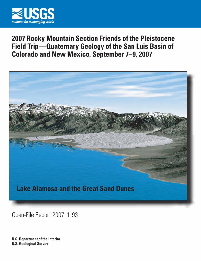
Lake Alamosa and the Great Sand Dunes

2007 Rocky Mountain Section Friends of the Pleistocene Field Trip— Quaternary Geology of the San Luis Basin of Colorado and New Mexico, September 7–9, 2007
By Michael N. Machette, Mary-Margaret Coates, and Margo L. Johnson
Open-File Report 2007–1193
U.S. Department of the InteriorU.S. Geological Survey

U.S. Department of the InteriorDIRK KEMPTHORNE, Secretary
U.S. Geological SurveyMark D. Myers, Director
U.S. Geological Survey, Reston, Virginia: 2007
For product and ordering information: World Wide Web: http://www.usgs.gov/pubprod Telephone: 1-888-ASK-USGS
For more information on the USGS—the Federal source for science about the Earth, its natural and living resources, natural hazards, and the environment: World Wide Web: http://www.usgs.gov Telephone: 1-888-ASK-USGS
Any use of trade, product, or firm names is for descriptive purposes only and does not imply endorsement by the U.S. Government.
This publication has not been reviewed for stratigraphic nomenclature.
Although this report is in the public domain, permission must be secured from the individual copyright owners to reproduce any copyrighted materials contained within this report.
Suggested citation:Machette, M.N., Coates, M-M., and Johnson, M.L., 2007, 2007 Rocky Mountain Section Friends of the Pleistocene Field Trip—Quaternary geology of the San Luis Basin of Colorado and New Mexico, September 7–9, 2007: U.S. Geo-logical Survey Open-File Report 2007–1193, 197 p.; available at <http://pubs.usgs.gov/of/2007/1193
CoverA modern restoration of Lake Alamosa. View to the northeast from above the San Luis Hills, southeast of Alamosa, Colo. Visualization created in Visual Nature Studio (v. 2.7, 3D Nature Co.) by Paco Van Sistine (USGS) using 30-m DEM and a lake elevation of 7,660 ft (2,335 m).

iii
Contents
Field-Trip Leaders ........................................................................................................................................viiPrologue .......................................................................................................................................................viiiFriends of the Pleistocene Rocky Mountain Section List of Annual Trips ............................................xField Trip Guidebook
Chapter A — Field-Trip Day 1—Quaternary geology of Great Sand Dunes National Park and Preserve, southern Colorado (Valdez, Forman, McCalpin, Madole, Machette, Schumann, Rupert, Mahan, Bunch) .....................................................................................3
Orientation for Day 1—Friday, Sept. 7, 2006 ............................................................................3Stop A1—Development and eolian geomorphology of Great Sand Dunes (Valdez) ........7Stop A2—Optical dating of episodic dune movement at Great Sand Dunes National
Park and Preserve (Forman) .......................................................................................11Stop A3—Paleoseismology of range-front fault scarps at Great Sand Dunes
(McCalpin) .....................................................................................................................19Stop A4—Parabolic dune migration across the southern sand sheet (Forman) ............24Stop A5—Cattle-guard Paleoindian site (Bunch, Jodry) ....................................................30Stop A6—Medano Ranch area (Madole, Mahan, Rupert) .................................................30Stop A7—Sabkha overlook (Valdez) .......................................................................................36Stop A8 (optional)—Closed basin overflow and origin of Hansen Bluff (Valdez) ...........38Stop A9 (optional)—Middle and late Holocene eolian sand dunes (Machette) .............40Stop A10—Late Pleistocene to early Holocene wetland deposits in the Mr. Peat pit
(Machette, Schumann) ...............................................................................................42
Chapter B — Field-Trip Day 2—Quaternary geology of Lake Alamosa and the Costilla Plain, southern Colorado (Machette, Thompson, Marchetti, Kirkham) .......................53
Orientation for Day 2—Saturday, Sept. 8, 2007 .....................................................................53Stop B1—Deposits of Lake Alamosa at the Bachus pit (Machette) .................................57Stop B2—Soil on intermediate-age alluvium (post–Lake Alamosa), Sanford, Colo.
(Machette) .....................................................................................................................61Stop B3—Soils on and experimental dating of lacustrine gravels of Lake Alamosa
at Saddleback Mountain (Machette, Marchetti) ...................................................63Stop B4—Overview of the Rio Grande outlet (Machette, Thompson) ..............................71Stop B5 (optional) —Lagoons and barrier bars of ancient Lake Alamosa
(Machette) .....................................................................................................................78Stop B6 (optional)—And the wind blows—Fluted ventifacts on the ancient shore
of Lake Alamosa (Machette) ......................................................................................81Stop B7 (optional)—Hansen Bluff—Alamosa Formation (Machette) ..............................85Stop B8—Mesita Hill: An early Pleistocene volcano adrift in a sea of dirt
(Machette, Thompson, Kirkham) ...............................................................................89Stop B9—Landslides and the Sangre de Cristo fault zone along San Pedro
Mesa (Machette) ........................................................................................................100
iv
Chapter C—Field-Trip Day 3—Quaternary geology of Sunshine Valley and associated neotectonics along the Latir Peaks section of the Southern Sangre de Cristo fault zone (Ruleman, Shroba, Thompson) .......................................................................111
Overview....................................................................................................................................111Stop C1—Volcanic and geomorphic setting of the Sunshine Valley and Taos
Plateau (Thompson, Ruleman) .................................................................................112Stop C2—Highest depositional surface within Sunshine Valley (Ruleman, Shroba) ...114Stop C3—Faulted Servilleta Basalt (3.66–4.75 Ma) at Latir Creek (Ruleman) ...............116Stop C4—Old Alluvium (unit Qao2) overlying Servilleta Basalt and Santa Fe
Formation (Shroba, Ruleman) ...................................................................................120Stop C5—Ute Mountain volcanic rocks and fan deposits and surficial geology of
northern Sunshine Valley (Thompson, Shroba) .....................................................121Stop C6—Faulted alluvium at Jaroso Canyon, Latir Peaks section of the southern
Sangre de Cristo fault zone (Ruleman) ...................................................................125Stop C7—Piedmont fault scarp on Cedro Canyon fan (Ruleman) ...................................128
PapersChapter D—Ground-water age and flow at Great Sand Dunes National Monument,
south-central Colorado (Rupert and Plummer) ..............................................................135Chapter E—Dating and stratigraphy of middle to late Holocene eolian sand deposits
in the San Luis Basin, east of Alamosa, Colorado (Machette and Puseman) ...........139Chapter F—Late Pleistocene to early Holocene paleoecology of the Mr. Peat wetland
deposit, Alamosa County, Colorado (Schumann and Machette) ................................147Chapter G—Ancient Lake Alamosa and the Pliocene to middle Pleistocene evolution
of the Rio Grande (Machette, Marchetti, and Thompson) ...........................................157Chapter H—Geology of Mesita volcano, Colorado—Eruptive history and implications
for basin sedimentation during the Quaternary (Thompson, Machette, Shroba, and Ruleman) .......................................................................................................................169
Chapter I—Possible role of eolian sediment in the genesis of bouldery debris-flow deposits on the lower flanks of Ute Mountain, northern Taos Plateau volcanic field, New Mexico (Shroba, Thompson, and Ruleman) ................................................181
Chapter J—An overview of the Sangre de Cristo fault system and new insights into interactions between Quaternary faults in the northern Rio Grande rift (Ruleman and Machette) .....................................................................................................................187

v
Conversion Factors
Units of measureThe U.S. Geological Survey uses international units of measure (meters, kilometers, kilograms,
etc), so our normal policy is to use only these units. However, because this guidebook deals with distances that are always shown in miles on road signs and automobile odometers, and because all of the detailed topographic maps (1:24,000-scale) use feet as the measure of elevation, we feel compelled to provide both units. Thus, for this report our convention for reporting units of measure will be as follows:
For distances, we use kilometers (and miles)
For elevations, we use feet (and meters) asl (above sea level)
For thickness in measured section and heights above or below some datum (such as stream level or canyon rim), we use only metric (meters or kilometers).
For areas and volumes, we use only metric (cm2, m2, or km2; cm3, m3, or km3)
For weights, we use only metric (grams or kilograms)
The following table lists conversion factors useful for this report:
Multiply SI unit By To obtain English unit
Lengthcentimeter (cm) 0.3937 inch (in.)
millimeter (mm) 0.03937 inch (in.)
meter (m) 3.281 foot (ft)
kilometer (km) 0.6214 mile (mi)
Areasquare centimeter (cm2) 0.1550 square inch (ft2)
square centimeter (cm2) 0.001076 square foot (ft2)
square meter (m2) 10.76 square foot (ft2)
square meter (m2) 0.0002471 acre
square kilometer (km2) 247.1 acre
square kilometer (km2) 0.3861 square mile (mi2)
Temperature in degrees Celsius (°C) may be converted to degrees Fahrenheit (°F) as follows: °F=(1.8×°C)+32
Temperature in degrees Fahrenheit (°F) may be converted to degrees Celsius (°C) as follows: °C=(°F–32)/1.8
Vertical coordinate information is referenced to the insert datum name (and abbreviation) here, for instance, “North American Vertical Datum of 1988 (NAVD 88)”
Horizontal coordinate information is referenced to the insert datum name (and abbreviation) here, for instance, “North American Datum of 1983 (NAD 83)”
Altitude, as used in this report, refers to distance above the vertical datum.

vi
Abbreviations Used in This ReportUnits of measure Initialisms
14C carbon 14 (radiocarbon)
14C yr radiocarbon years
asl above sea level
cal yr B.P. calibrated years before present
cm centimeter, centimeters
cm/yr centimeters per year
ft foot, feet
ft/mi feet per mile
g gram
g/cm2 gram per square centimeter
Gy Gray (a measure of absorbed dose for luminescence dating)
ka thousands of years ago
km kilometers
k.y. thousands of years (duration of time)
m meter, meters
m/s meters per second
m/yr meters per year
mGy/yr milli-Grays per year
mi miles
mm millimeter, millimeters
mm/yr millimeters per year
mW/cm2 milliwatts per square centimeter
nm nanometers
nT nano-Tesla
s second, seconds
torr unit of pressure; 1 torr = 133.322368 pascals
wt percent weight percent
yr year
AMS accelerator mass spectrometry
BLM Bureau of Land Management
B.P. before present
DP drift potential
EROS Earth Resources Observation System
ETM enhanced thematic mapper
FOP Friends of the Pleistocene
GSDNPP Great Sand Dunes National Park and Preserve
HF hydrofluoric acid
ICP-MS inductively coupled plasma–mass spectrometry
IRSL infrared stimulated luminescence
M moment magnitude
Mw
moment magnitude
Ms
moment magnitude
MAP mean annual precipitation
MAT mean annual temperature
NAD27 North American Datum of 1927
NOSAMS National Ocean Sciences Accelerator Mass Spectrometry facility
NPS U.S. National Park Service
OIS oxygen-isotope stage
OSL optically stimulated luminescence
PD parabolic dune
PE paleoevent
PDSI Palmer Drought Severity Index
RDD resultant drift direction
RDP resultant drift potential
RDP/DP ratio of resultant drift potential to resultant drift direction
RMMP (private company)
SAR single aliquot regeneration
SCS Soil Conservation Service
TCN terrestrial cosmogenic nuclide
U.S.A. United States of America
USGS U.S. Geological Survey
UTM Universal Transverse Mercator

vii
Abbreviations Used in This ReportUnits of measure Initialisms
14C carbon 14 (radiocarbon)
14C yr radiocarbon years
asl above sea level
cal yr B.P. calibrated years before present
cm centimeter, centimeters
cm/yr centimeters per year
ft foot, feet
ft/mi feet per mile
g gram
g/cm2 gram per square centimeter
Gy Gray (a measure of absorbed dose for luminescence dating)
ka thousands of years ago
km kilometers
k.y. thousands of years (duration of time)
m meter, meters
m/s meters per second
m/yr meters per year
mGy/yr milli-Grays per year
mi miles
mm millimeter, millimeters
mm/yr millimeters per year
mW/cm2 milliwatts per square centimeter
nm nanometers
nT nano-Tesla
s second, seconds
torr unit of pressure; 1 torr = 133.322368 pascals
wt percent weight percent
yr year
AMS accelerator mass spectrometry
BLM Bureau of Land Management
B.P. before present
DP drift potential
EROS Earth Resources Observation System
ETM enhanced thematic mapper
FOP Friends of the Pleistocene
GSDNPP Great Sand Dunes National Park and Preserve
HF hydrofluoric acid
ICP-MS inductively coupled plasma–mass spectrometry
IRSL infrared stimulated luminescence
M moment magnitude
Mw
moment magnitude
Ms
moment magnitude
MAP mean annual precipitation
MAT mean annual temperature
NAD27 North American Datum of 1927
NOSAMS National Ocean Sciences Accelerator Mass Spectrometry facility
NPS U.S. National Park Service
OIS oxygen-isotope stage
OSL optically stimulated luminescence
PD parabolic dune
PE paleoevent
PDSI Palmer Drought Severity Index
RDD resultant drift direction
RDP resultant drift potential
RDP/DP ratio of resultant drift potential to resultant drift direction
RMMP (private company)
SAR single aliquot regeneration
SCS Soil Conservation Service
TCN terrestrial cosmogenic nuclide
U.S.A. United States of America
USGS U.S. Geological Survey
UTM Universal Transverse Mercator
Edited by Michael N. Machette, Mary-Margaret Coates, and Margo L. Johnson
Field-trip leaders:
Day 1—Andrew Valdez, Steve Forman, Richard Madole, Jim McCalpin, Michael Machette, Mike Rupert, Randy Schumann, Shannon Mahan, Pegi Jodry, and Fred Bunch
Day 2—Michael Machette, Ren Thompson, David Marchetti, and Robert Kirkham
Day 3—Cal Ruleman, Ren Thompson, Ralph Shroba, and David Marchetti
viii
2007 Rocky Mountain Cell Friends of the Pleistocene Field Trip—Quaternary Geology of the San Luis Basin of Colorado and New Mexico, September 7–9, 2007
PrologueWelcome to the 2007 Rocky Mountain Cell Friends of the Pleistocene Field Trip, which
will concentrate on the Quaternary geology of the San Luis Basin of Colorado and New Mex-ico. To our best knowledge, Friends of the Pleistocene (FOP) has never run a trip through the San Luis Basin, although former trips in the region reviewed the “Northern Rio Grande rift” in 1987 and the “Landscape History and Processes on the Pajarito Plateau” in 1996. After nearly a decade, the FOP has returned to the Rio Grande rift, but to an area that has rarely hosted a trip with a Quaternary focus. The objective of FOP trips is to review—in the field—new and exciting research on Quaternary geoscience, typically research being conducted by graduate students. In our case, the research is more topically oriented around three areas of the San Luis Basin, and it is being conducted by a wide range of Federal, State, academic, and consulting geologists.
This year’s trip is ambitious—we will spend our first day mainly on the Holocene record around Great Sand Dunes National Park and Preserve, the second day on the Quaternary stratig-raphy around the San Luis Hills, including evidence for Lake Alamosa and the 1.0 Ma Mesita volcano, and wrap up the trip’s third day in the Costilla Plain and Sunshine Valley reviewing alluvial stratigraphy, the history of the Rio Grande, and evidence for young movement on the Sangre de Cristo fault zone.
In the tradition of FOP trips, we will be camping along the field trip route for this meeting. On the night before our trip, we will be at the Great Sand Dunes National Park and Preserve’s Pinyon Flats Campground, a group facility located about 2 miles north of the Visitors Center. After the first day’s trip, we will dine and camp in the Bachus pit, about 3 miles southwest of Alamosa. For the final night (after day 2), we will bed down at La Junta Campground at the Bureau of Land Management (BLM) Wild and Scenic Rivers State Recreation Area, west of Questa, New Mexico, overlooking a majestic canyons of the Rio Grande and Red River.
This is the 48th meeting of the Rocky Mountain Section of FOP, which was initiated by Gerry Richmond (USGS-Denver, deceased) in 1952 (see the following table, which lists all the Rocky Mountain Section field trips). The Rocky Mountain Section has been inactive for three years owing to a series of problems, including an unfortunate cancellation of Dennis Dahms’ trip to the southern Wind River Range in 2005. Hopefully, this year’s trip will provide the logis-tical initiative and scientific momentum for future Friends of the Pleistocene trips in the Rocky Mountain region.
Michael Machette Organizer and Editor
2007 FOP Rocky Mountain Section

ix
Figure 1. Route map for the FOP trip, days 1, 2, and 3. More detailed maps for each day are included in chapters A, B, and C (respectively) in this volume.
Taos
Costilla
Alamosa
Conejos
HuerfanoSaguache
Colfax
Rio
Arr
iba
Rio
Gra
nd
e
FortGarland
Blanca
Antonito
La Jara
SanLuis
Questa
CostillaNEW MEXICO
COLORADO
Alamosa
0 10 20 30 40 Km5
3
DAY 3
DAY 2
DAY 2
DAY 1
DAY 2(OPT.)
Start Day 1
Start Day 2
285
285
285
160
160
160
159
17
3
378
Start Day 3
End Day 3

x
FRIENDS OF THE PLEISTOCENE ROCKY MOUNTAIN SECTION LIST OF ANNUAL TRIPS
This section (or cell) was organized by Gerry Richmond in May 1952 at the Rocky Mountain Section meeting of the Geological Society of America at Salt Lake City, Utah No. Year Date Area or title and leaders
1 1952 Oct. 4–5 Rocky Mountain National Park, Colorado: Gerald Richmond2 1953 Oct. 3–4 Twin Lakes area, Colorado: Gerald Richmond3 1954 Oct. 9–10 Medicine Bow–Laramie area, Wyoming: S.H. Knight--- 1955–
1957No trip conducted
4 1958 Sept. 5–7 Jackson Hole area, Wyoming: J.D. Love, John Montagne5 1959 Sept. 12–13 Pinedale and Lander areas, Wyoming: Gerald Richmond6 1960 Sept. 10–11 Little Cottonwood Creek area, Salt Lake County, Utah: Henry Goode, Roger
Morrison7 1961 Aug. 25–26 Bear Lake Valley, Utah–Idaho, to American Falls, Idaho: J. Stewart Williams,
Donald Trimble, Allan Willard, Verlyn Parker8 1962 Aug. 24–26 Twin Falls to Glenns Ferry, Idaho (Snake River Canyon): Harold Malde, Howard
Powers, Dwight Taylor9 1963 Aug. 23–24 Madison River Valley and Yellowstone River Valley from Hayden Valley to Pine
Creek, Montana: John Good, J.D. Love, John Montagne10 1964 Aug. 28–30 Quaternary geology of the Duncan-Virden-Safford area, New Mexico: Roger
Morrison--- 1965 No FOP trips, in light of the 1965 INQUA meeting in Boulder, Colo.11 1966 Aug. 26–28 Landscape evolution and soil genesis in the Rio Grande region, southern New
Mexico (Desert Project, Soil Investigations, Soil Conservation Service): John Hawley, Leland Gile
12 1967 Aug. 25–27 Western Snake River Plain, Idaho: Harold Malde13 1968 Sept. 21–22 San Pedro Valley and Murray Springs archeological site, Arizona: Vance Haynes,
Larry Aggenbroad, Peter Mehringer, Paul Martin, Everett Lindsay, William Wasley, Thomas Hemmings
14 1969 Oct. 4–5 Jordan Valley, Utah: Richard Van Horn, Edward Weakly15 1970 Oct. 2–4 San Francisco Peaks (Flagstaff area): Troy Péwé, R.G. Updike16 1971 Oct. 9–10 Bishop–Mono Lakes area, California: Michael Sheridan17 1972 Sept. 9–10 Canon City–Westcliffe area (Wet Mountain Valley), Colorado: Glenn Scott,
Richard Taylor, Rudy Epis18 1973 Sept. 15–16 Mt. Sopris–Thomas Lakes area, Colorado: Peter Birkeland, Ralph Shroba, James Yount19 1974 Sept. 6–7 West Yellowstone–Gallatin River–Three Forks area, Montana: John Montagne,
Cliff Montagne, Ken Pierce, Leslie Davis20 1975 Oct. 17–18 Southern High Plains, Texas: C.C. Reeves, Jr., James Goolsby, Charles Johnson,
Eileen Johnson, John Hawley21 1976 Aug. 27–28 Plains of southern Alberta (Canada): Chester Beaty, Rene Barendregt, John Dor-
maar, Stuart Harris, Archie Stalker22 1977 Aug. 2–3 Natural Trap cave, Lovell, Wyoming: B. Miles Gilbert23 1978 July 29–30 Hot Springs Mammoth site, South Dakota: L.D. Agenbroad24 1979 July 9–10 Agate Basin archeological site, Wyoming: George Frison--- 1980 No trip conducted25 1981 Sept. 19–20 Roaring Fork Valley and Twin Lakes and Chalk Creek areas, central Colorado:
Alan Nelson, Lucy Piety, Ralph Shroba26 1982 Sept. 17–19 Little Valley, Jordan Valley, and Beaver Basin, Utah: William Scott, Michael
Machette, Ralph Shroba, William McCoy27 1983 Aug. 26–28 Three trips—(1) Jokulhlaups in to the Sanpoil arm of glacial Lake Columbia,
Washington: Brian Atwater; (2) Jokulhlaups near Spokane, Washington, and Lewiston, Idaho: Richard Waitt; (3) Glacial sequence near McCall, Idaho: Steven Colman, Ken Pierce, Richard Fosberg

xi
28 1984 Aug. 10–11 Northern Bighorn Basin, Wyoming–Montana: Marith Reheis, Dale Ritter, Robert Palmquist
29 1985 Sept. 19–20 Animas Valley, Colorado–New Mexico: Mary Gillam, Robert Blair30 1986 Sept. 6–7 Yellowstone National Park, Wyoming–Montana–Idaho: William Locke, Grant
Meyer, Wayne Hamilton, John Montagne, David Nash, Steven Personius, Ken Pierce, Gerald Richmond
31 1987 Oct. 8–11 Northern Rio Grande rift, New Mexico: Dave Dethier, Chuck Harrington, Dave Love, Chris Menges, Steve Wells, John Wesling, Ralph Shroba
32 1988 Oct. 14–15 Tonto Basin, central Arizona: Larry Anderson, Lucy Piety, Dale Nations, Jim Faulds, Joel Sturm, Cathy Wellendorf
33 1989 Aug. 17–21 Wind River Mountains, Wyoming: Peter Birkeland, Curt Sorenson, Ralph Shroba, Dennis Dahm, Bob Hall
34 1990 Aug. 15–19 Quaternary geology of the western Madison Range, Madison Valley, Tobacco Root Range, and Jefferson Valley: Robert Hall, Ken Adams, Bill Locke, Scott Lundstrom, and ten others
35 1991 Oct. 11–13 Lake Bonneville stratigraphy and Quaternary volcanism in the Sevier and Black Rock Deserts, Utah: Charles (Jack) Oviatt (ed.), William McCoy, William Nash
36 1992 Sept. 11–13 Quaternary geology of Jackson Hole, Wyoming: Ken Pierce, John Good37 1993 Sept. 10–12 Quaternary geology of the Mission Valley, Montana: Dan Levish, Dean Ostenaa,
Ralph Klinger38 1994 Aug. 13–14 Quaternary geology of the Wind River Basin, Wyoming: Oliver Chadwick, Bob
Hall, Gene Kelley, Ronald Amundson, John Gosse, Fred Phillips, Cheryl Jaworoski
39 1995 Aug. 25–27 Late Pleistocene–Holocene evolution of the northeastern Yellowstone landscape: Grant Meyer (ed.), James Anderson, Matthew Bingham, Peter O’Hara, Eric Simpson, Kenneth Pierce
40 1996 Sept. 12–15 Landscape history and processes on the Pajarito Plateau, northern New Mexico: Steve Reneau, Eric McDonald, Craig Allen, David Broxton, Jamie Gardner, Rory Gauthier, Keith Kelson, William Phillips, Bradford Wilcox
41 1997 Oct. 12–14 The active geologic environment of central Colorado—Aspen–Glenwood Springs area, Colorado: Jim McCalpin (ed.), Bob Kirkham, Bruce Stover, Jim White
42 1998 Sept. 10–13 Soil, water, and earthquakes around Socorro, New Mexico: Bruce Harrison (ed.), Dave Love, Carol Treadwell-Stietz, Dennis McMahon, Michael Machette, Allen Gellis, Milan Pavih, Missy Eppes, Fred Phillips, John Hawley, Frank Pazzaglia, and Dan Koning. Included premeeting (Sept. 10) and postmeeting (Sept. 13) trips
43 1999 Sept. 10–12 Quaternary and environmental geology of the southwestern San Juan Mountains, Colorado: Mary Gillam, Robert Blair, Stanley Church, Scott Elias, Robert Kirkham, Thomas Perry, Fred Phillips, and others
44 2000 Sept. 22–24 Red Gate to Blue Gate–Lava-boulder diamicts and gravel, Aquarius Plateau through Waterpocket Fold (Capitol Reef), Utah: Richard Waitt (ed.), Thure Cerling, Dave Marchetti, Lee Kreutzer, Adrienne Anderson
45 2001 Oct. 12–14 Plio-Pleistocene stratigraphy and geomorphology of the central part of the Albu-querque Basin: Sean Connell, David Love, John Sorrell, Bruce Harrison
46 2002 Oct. 11–13 Quaternary stratigraphy and tectonics, and Late Prehistoric agriculture of the Safford Basin (Gila and San Simon River valleys), Graham County, Arizona: Brenda Houser, Philip Pearthree, Jeffry Homburg, Lawrence Thrasher
47 2003 Sept. 5–7 Fan-tastic, flaming, firn-filled fluvial FOP [central Idaho]: Jennifer Pierce (ed.), Grant Meyer, Charlie Luce, Tom Black, Glenn Thackray, Spencer Wood
--- 2004 No trip conducted--- 2005 July 29–31
(canceled)Glacial stratigraphy, erosion, and paleoenvironments of the southern Wind River
Range, Sinks Canyon, Lander, Wyoming: Dennis Dahms--- 2006 No trip conducted48 2007 Sept. 7–9 Quaternary geology of the San Luis basin, southern Colorado and northern New
Mexico: Michael Machette, Cal Ruleman, Ralph Shroba, David Marchetti, Ren Thompson, Andrew Valdez, Steve Forman, and others

Machette, Coates, Johnson—
Quaternary G
eology of the San Luis Basin, Colorado and N
ew M
exico—Open-File Report 2007–1193