Embed Size (px)
Citation preview
THETIS Scoping Report (Final).docx © Copyright THETIS Energy Ltd, September 2009
THETIS Energy Ltd
Proposed Torr Head Tidal Scheme
Environmental Scoping Report
September 2009

Environmental Scoping Report Proposed Torr Head Tidal Scheme
This page is intentionally blank

Environmental Scoping Report Proposed Torr Head Tidal Scheme
Page i
Preface
This Scoping Report has been produced for a consortium (THETIS Energy Ltd) comprising three companies: Statkraft UK Ltd (which is part of the Statkraft Group of Norway), B9 Energy Offshore Developments Ltd and Deepblue Renewables Ltd. The three companies have formed the consortium in order to examine the viability of establishing a commercial marine current tidal energy scheme in waters off the coast of County Antrim, Northern Ireland. This report has been produced for THETIS Energy Ltd with specialist contributions from RPS Group plc and Project Management Support Services Ltd (“PMSS”).
This report follows on from a series of initial meetings and correspondence held to establish the scope of environmental studies for assessing the impact of the proposed tidal scheme. It is issued for consultation. Electronic copies in pdf format can be downloaded from www.ThetisEnergy.com. Further hard copies of this report can be obtained from B9 Energy Offshore Developments Ltd at the address below:
B9 Energy Offshore Developments Ltd 133c High Street Holywood BT18 9LG
Email: [email protected]
September 2009
Copyright declaration under copyright licence 13701: The extract of Admiralty Chart (Figure 5 on page 9) is reproduced by permission of the Controller of Her Majesty’s Stationery Office and the UK Hydrographic Office (www.ukho.gov.uk).

Environmental Scoping Report Proposed Torr Head Tidal Scheme
Page ii
Contents
1 Background Information ................................................................................................................................................................ 1 2 Legislative and Policy Context ......................................................................................................................................................... 4 3 Project Outline .............................................................................................................................................................................. 8 4 Physical Environment ................................................................................................................................................................... 21 5 Biological Environment ................................................................................................................................................................ 29 6 Human Environment ................................................................................................................................................................... 41 7 Cumulative Impacts ..................................................................................................................................................................... 55
Figures
Figure 1: Environmental Assessment Flowchart ........................................................................................................................................... 2 Figure 2: Development area refinement process .......................................................................................................................................... 8 Figure 3: Area of potential for commercial marine tidal projects .................................................................................................................. 8 Figure 4: Initial area for preliminary analysis and scoping ............................................................................................................................. 9 Figure 5: Final area for preliminary analysis and scoping .............................................................................................................................. 9 Figure 6: Variation in Spring – Neap cycle for tide height at Portrush ......................................................................................................... 10 Figure 7: Typical tidal conditions expected at mid-ebb within the North Channel ........................................................................................ 11 Figure 8: Wind Speed Distribution in the North Channel ............................................................................................................................ 11 Figure 9: Bathymetry of region ................................................................................................................................................................. 12 Figure 10: Illustrative drawing showing marine tidal turbine components. ................................................................................................. 13 Figure 11: Different turbine concept options ............................................................................................................................................. 14 Figure 12: Analysis and comparison of support structure concepts for tidal stream turbines [] ..................................................................... 14 Figure 13: Illustrative schematic layout of project and turbine arrays .......................................................................................................... 15 Figure 14: Seabed Sediments (OneGeology website, 2009) ........................................................................................................................ 21 Figure 15: Torr Head Area of Special Scientific Interest (ASSI) ..................................................................................................................... 23 Figure 16: Extract of 1:250,000 Solid Geology Map of Northern Ireland (GIS data courtesy of GSNI) ........................................................... 24 Figure 17: Extract of 1:250,000 Drift Geology Map of Northern Ireland (GIS data courtesy of GSNI) ............................................................ 24 Figure 18: Torr Head headland showing exposed geological features of national and international importance ........................................... 24 Figure 19: Rathlin Island Special Protection Area ....................................................................................................................................... 29 Figure 20: Extent of RoxAnn survey within the area of investigation ........................................................................................................... 35 Figure 21: Salmonid spawning rivers......................................................................................................................................................... 39 Figure 22: Main Potting Activity along the Antrim Coastline (GIS data supplied by AFBI) ............................................................................. 44 Figure 23: Main Trawling Activity along the Antrim Coastline (GIS data supplied by AFBI) ........................................................................... 45 Figure 24: Antrim Coast and Glens AONB (outlined in purple on map) ....................................................................................................... 46 Figure 25: Fair Head Landscape Character Area ......................................................................................................................................... 47 Figure 26: Archaeological Sites in Vicinity of Torr Head .............................................................................................................................. 49 Figure 27: Known Shipwrecks in Vicinity of Torr Head ............................................................................................................................... 50 Figure 28: Antrim Coast and Glens (waymarked tracks) ............................................................................................................................. 52
Tables
Table 1: Scoping opinion consultees ........................................................................................................................................................... 3 Table 2: Co-ordinates of final area for preliminary analysis and scoping ...................................................................................................... 10 Table 3: Turbine and nacelle characteristics ............................................................................................................................................... 13 Table 4: Relevant coastal processes guidance documents ........................................................................................................................... 23 Table 5: Relevant geology guidance documents ........................................................................................................................................ 25 Table 6: Relevant noise guidance documents ............................................................................................................................................ 28 Table 7: Relevant conservation guidance documents ................................................................................................................................. 30 Table 8: Relevant ornithology guidance documents ................................................................................................................................... 32 Table 9: Relevant large marine species guidance documents ...................................................................................................................... 34 Table 10: Description of benthic habitats .................................................................................................................................................. 35 Table 11: Relevant benthic and inter-tidal ecology guidance documents .................................................................................................... 37 Table 12: Relevant terrestrial ecology guidance documents ........................................................................................................................ 38 Table 13: Potential spawning and nursery grounds within area of investigation .......................................................................................... 38 Table 14: Relevant fish and shellfish ecology guidance documents ............................................................................................................. 40 Table 15: Relevant shipping and navigation guidance documents .............................................................................................................. 43 Table 16: Relevant commercial fisheries guidance documents .................................................................................................................... 46 Table 17: Relevant landscape and seascape guidance documents .............................................................................................................. 48 Table 18: Relevant archaeology and cultural heritage guidance documents ................................................................................................ 51 Table 19: Potential cumulative impacts with other relevant projects ........................................................................................................... 55
Environmental Scoping Report Proposed Torr Head Tidal Scheme
Page iii
Appendices
Appendix 1 Outline Survey Scopes Appendix 2 Scoping (Consultation Responses and Scoping Consultation List) Appendix 3 Conservation Designations Appendix 4 Proposed Structure of Environmental Statement
Abbreviations
ADCP Acoustic Doppler Current Profiling ADD Acoustic Deterrent Devices AFBI Agri-Food and Biosciences Institute AIS Automatic Identification Systems ALARP As Low As Reasonably Practicable AONB Area of Outstanding Natural Beauty ASSI Area of Special Scientific Interest ATBA Area To Be Avoided BERR Department of Business, Enterprise and Regulatory Reform (now DECC, a UK Government Department) BGS British Geological Survey BS British Standard BTO British Trust for Ornithology BWEA British Wind Energy Association CCTV Closed Circuit Television CD Chart Datum CEFAS Centre for Environment, Fisheries and Aquaculture Science CYCC Conference of Yacht Cruising Clubs DARD Department of Agriculture and Rural Development DCAL Department of Culture, Arts and Leisure DECC Department of Energy and Climate Change (a UK Government department) DETI Department of Enterprise, Trade and Investment DoENI Department of the Environment Northern Ireland DSC Digital Selective Calling COWRIE Collaborative Offshore Wind Research into the Environment EIA Environmental Impact Assessment EMS Environmental Management System EPRI Electric Power Research Institute EPS European Protected Species ES Environmental Statement EU European Union FEPA Food and Environment Protection Act 1985 FLO Fisheries Liaison Officer FLOWW Fishing Liaison with Offshore Wind and Wet Renewables Group GLA General Lighthouse Authority GSNI Geological Survey Northern Ireland HWMS High Water Mean Spring IMO International Maritime Organisation ISO International Organisation for Standardisation IWDG Irish Whale and Dolphin Group JIBS Joint Irish Bathymetric Survey JNCC Joint Nature Conservation Committee km kilometres m metres m/s Metres per second MCA Maritime and Coastguard Agency MCT Marine Current Turbines MGN Marine Guidance Note MMOs Marine Mammal Observers MMO Marine Management Organisation MoD Ministry of Defence (a UK Government Department) MW Megawatts NFFO National Federation of Fishermans Organisations NIAUR Northern Ireland Authority for Utility Regulation NIE Northern Ireland Electricity NIEA Northern Ireland Environment Agency NIFPO Northern Ireland Fish Producers Organisation

Environmental Scoping Report Proposed Torr Head Tidal Scheme
Page iv
NM Nautical Miles NMMP National Marine Monitoring Programme NRA Navigational Risk Assessment ODB Ordnance Datum Belfast OFREG Office for the Regulation of Electricity and Gas OREI Offshore Renewable Energy Installation OS Ordnance Survey PMSS Project Management Support Services Ltd PSU Public Services & Utilities RAM Restricted in their Ability to Manoeuvre RDS Regional Development Strategy RNLI Royal National Lifeboat Institution ROV Remotely Operated Vessel RSPB Royal Society for the Protection of Birds RYANI Royal Yachting Association Northern Ireland SAC Special Area of Conservation SAP Strategic Action Plan SDC Sustainable Development Commission SEA Strategic Environmental Assessment SEI Sustainable Energy Ireland SMRU Sea Mammal Research Unit SPA Special Protection Area TSS Traffic Separation Scheme UKHO United Kingdom Hydrographic Office VHF Very High Frequency VTS Vessel Traffic Services WHO World Health Organisation ZTV Zone of Theoretical Visibility
Environmental Scoping Report Proposed Torr Head Tidal Scheme
Page v
Executive Summary
The purpose of this Scoping Report is to establish the scope of studies for assessing the nature, magnitude and significance of environmental changes caused directly, indirectly and cumulatively by the proposed tidal energy scheme located off Torr Head on the coast of County Antrim, Northern Ireland
This report has been prepared for consideration by the Department of Enterprise, Trade and Investment (DETI) under the Offshore Electricity Development (Environmental Impact Assessment) Regulations (Northern Ireland) 2008, the Northern Ireland Environment Agency (NIEA) for the Department of Environment Northern Ireland (DoENI) under the Food and Environmental Protection Act 1985, the Planning Service Northern Ireland under Planning (Environmental Impact Assessment) Regulations 1999 and all other interested parties. It is a tool to ensure that all relevant issues are assessed during the Environmental Impact Assessment (EIA) process.
The principal issues that have been identified to be included within the EIA in regard to the physical environment are coastal processes, geology, water quality and suspended sediments and noise. In regard to the biological environment the topics are conservation designations, ornithology, large marine species, benthic and intertidal ecology, terrestrial ecology and fish and shellfish ecology. And in regard to the human environment the issues considered are shipping and navigation, commercial fisheries, landscape and seascape, archaeology and cultural heritage and socio economic considerations including tourism and recreation. For each topic, the potential effects during the life of the project are identified, outline study methodologies to establish robust baselines and impact assessments are outlined, and potential mitigation measures identified.
The report outlines a number of project specific details including the rationale behind the site selection and a description of the physical characteristics of the proposed area. The key infrastructure components of the project are described including, turbines, cables, onshore works, array configuration and the phases of development. This preliminary project description has been outlined as a basis on which to assess the potential effects of the proposed development. It also highlights the positive environmental benefits likely to arise from the proposed tidal array development.
The EIA process, its approach and the general methodology to be adopted are outlined. A key element of the approach that should be noted, is that the exact details of the project design have not yet been finalised and as such, it is proposed that the EIA should satisfy case law and legislation by aiming to assess the ‘realistic worst case scenario’ arising from any chosen design.
This report proposes a structure for the Environmental Statement (ES), which will be prepared to collate and report the findings of the EIA. The ES will support the consent applications to DETI under Article 39 of the Electricity Order and a licence application to the DoENI under Section 5 of the Food and Environmental Protection Act, and, if applicable, the Planning Service Northern Ireland in respect of onshore works.
This report has been produced following initial consultation with a number of interested parties and will be used as a basis for further consultation with statutory and non statutory consultees.

Environmental Scoping Report Proposed Torr Head Tidal Scheme
Page 1
1 BACKGROUND INFORMATION
1.1. Purpose of Scoping Report
This scoping report is intended to serve two main purposes:
1. To provide supplemental information to regulators and key stakeholders on the proposed methodology for the Environmental Impact Assessment (EIA) of the proposed Torr Head Tidal Scheme.
2. To support a formal request for a scoping opinion and relevant additional information from the following regulatory bodies in respect of the proposed project:
• Department of Enterprise, Trade and Investment under regulations 5(1)(b) and 6(1) of The Offshore Electricity Development (Environmental Impact Assessment) Regulations (Northern Ireland) 2008 in respect of the content of an environmental statement required for an application for consent under Article 39 of The Electricity (Northern Ireland) Order 1992.
• Department of Environment Northern Ireland under regulation 13 of the Marine Works (Environmental Impact Assessment) Regulations 2007 in respect of the content of an environmental statement required for an application for consent to deposit materials on the seabed under the Food and Environment Protection Act 1985, supplemental to an initial request made in September 2008.
• Planning Service of Northern Ireland under regulations 6 and 7 of the Planning (Environmental Impact Assessment) Regulations (Northern Ireland) 1999, in respect of onshore elements of the project which may require planning permission.
1.2. The Proposed Development
The Torr Head Tidal Scheme (the “Project”) has been proposed by THETIS Energy Ltd to utilise the strong tidal resource on the north east coast of Northern Ireland for electricity generation. The scheme is proposed to have a target capacity of around 100-200 MW, consisting of an array of approximately 100 underwater horizontal axis turbines, each with a generating capacity of between 1 and 2 MW. The project scope of works will include the installation of the turbines and their foundations, sub-sea export cables, ancillary onshore works and the connection of the generating station to the onshore electricity distribution network.
1.3. The Developer
THETIS Energy Ltd (‘THETIS’) is a consortium comprising three companies: Statkraft UK Ltd, which is part of the Statkraft Group of Norway; B9 Energy Offshore Developments Ltd and Deepblue Renewables Ltd. The companies have formed a consortium to examine the viability of establishing a commercial marine current tidal scheme in the waters off Northern Ireland.
1.4. Environmental Impact Assessment (EIA) Scoping Process
In Northern Ireland a number of legislative instruments exist which govern the consenting process for offshore electricity generating stations. These are detailed fully in Section 2 (Legislative and Policy Context). As part of this consenting process the developer is required to undertake an EIA of the proposed development and submit an Environmental Statement (ES) detailing this work for consideration by the consenting authority.
The EIA process seeks to ensure that projects are assessed to ensure that those consenting projects have access to accurate and robust information concerning potentially significant adverse impacts upon the environment. The EIA process considers all phases of development, from construction through to decommissioning, to ensure that full lifecycle impacts are considered.
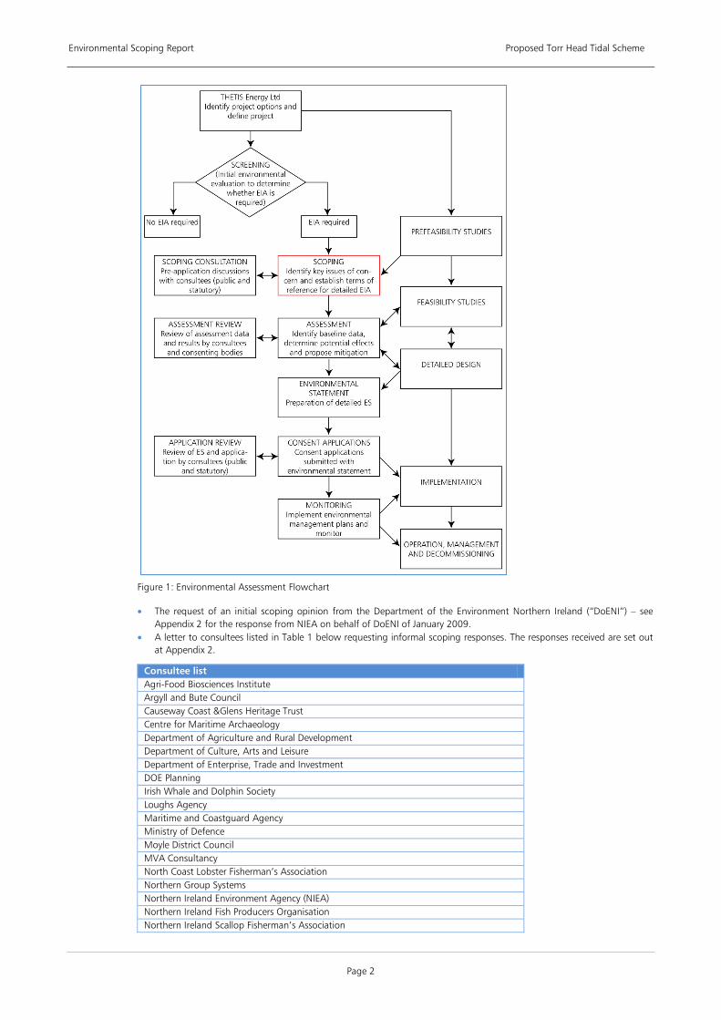
An Environmental Assessment Flowchart is illustrated in Figure 1, below. The EIA process is intended to ensure that projects are developed in a way that can best prevent, reduce or offset any significant adverse effects upon the environment. As can be seen from Figure 1, the process is intended to continue through to implementation phases of a project to ensure that appropriate monitoring and environmental plan management procedures are applied.
The scoping exercise itself (highlighted in red in Figure 1) forms an important and integral part of the environmental assessment process. Scoping is therefore a key stage in the EIA process as it is ultimately the foundation upon which the EIA and subsequent consenting decision is based. Well considered scoping is an iterative exercise used to identify the key issues of concern at an early stage in the planning process. The results of a scoping study will determine and establish the scope, depth and terms of reference of the EIA and subsequent ES. It is also important to acknowledge potentially positive environmental impacts and “scope out” effects considered not to be significant. This can be relevant for some renewable energy projects where benefits in respect of climate change mitigation may outweigh minor adverse environmental impacts.
1.4.1. Initial Consultation and Early Scoping
This report is supplemental to a number of early scoping and consultation exercises including:
• A preliminary consultation meeting with some principal statutory bodies to present the proposed project. This meeting, on 26th August 2008, included representatives from Department of Enterprise, Trade and Investment (DETI), Department of Agriculture and Rural Development (DARD), Northern Ireland Environment Agency (NIEA), and the Agri-food and Biosciences Institute (AFBI).
Environmental Scoping Report Proposed Torr Head Tidal Scheme
Page 2
Figure 1: Environmental Assessment Flowchart
• The request of an initial scoping opinion from the Department of the Environment Northern Ireland (“DoENI”) – see Appendix 2 for the response from NIEA on behalf of DoENI of January 2009.
• A letter to consultees listed in Table 1 below requesting informal scoping responses. The responses received are set out at Appendix 2.
Consultee list Agri-Food Biosciences Institute Argyll and Bute Council Causeway Coast &Glens Heritage Trust Centre for Maritime Archaeology Department of Agriculture and Rural Development Department of Culture, Arts and Leisure Department of Enterprise, Trade and Investment DOE Planning Irish Whale and Dolphin Society Loughs Agency Maritime and Coastguard Agency Ministry of Defence Moyle District Council MVA Consultancy North Coast Lobster Fisherman’s Association Northern Group Systems Northern Ireland Environment Agency (NIEA) Northern Ireland Fish Producers Organisation Northern Ireland Scallop Fisherman’s Association
Environmental Scoping Report Proposed Torr Head Tidal Scheme
Page 3
Sea Mammal Research Unit The Commissioners of Irish Lights The Crown Estate
Table 1: Scoping opinion consultees
1.4.2. Compilation of Scoping Report
In addition to the above consultations, a preliminary desktop study has been undertaken to establish background information on key topics, identify any relevant issues and to assess relevant data sources. The main sources of information considered in the compilation of this report are as follows:
• Existing databases, for example, NIEA databases for designated sites and monuments • Mapping (OS maps and Admiralty charts); • Reports, books, journals other published literature; and, • Information from statutory and non-statutory bodies.
This scoping study considers the significance of potential effects, including direct, indirect and cumulative impacts, and makes recommendations in terms of the scope of EIA methodology including desk top studies, survey requirements, consultation and possible mitigation. Any effects that have been ‘scoped-out’ have been justified as such in this report by reference to these criteria.
Although this scoping report is a standalone document summarising the scoping phase, the scoping process is not static, but will continue to be reviewed and refined throughout the environmental assessment and project design period in consultation with key stakeholders.
1.4.3. Invitation to Comment
THETIS Energy Ltd and the project team welcome further input into establishing the scope of work for the EIA. Specifically, consultees are invited to comment on the proposed scope of issues to be covered within the EIA and the proposed methodologies for assessing each issue. In addition, should consultees hold any data or environmental information that is relevant to the project or the area for assessment, they are invited to make such information available to advance the proposed studies. All responses will be taken into account in determining the final scope of the environmental assessment itself.
Responses and comments should be provided to THETIS Energy Ltd, at the following address:
B9 Energy Offshore Developments Ltd 133c High Street Holywood BT18 9LG
Email: [email protected]
Environmental Scoping Report Proposed Torr Head Tidal Scheme
Page 4
2 LEGISLATIVE AND POLICY CONTEXT 2.1. Energy Policy
2.1.1. International and EU Policy
It is widely recognised that the challenges of climate change caused by anthropogenic emissions of greenhouse gases, mainly from the use of fossil energy, need to be tackled effectively and urgently. Recent studies have contributed to growing awareness and knowledge of the problem and its long-term consequences, and have stressed the need for decisive and immediate action.
The EU Commission considers that an integrated approach to climate and energy policy is needed given that energy production and use are primary sources for greenhouse gas emissions. Increasing European dependence on energy imports threatens its security of supply and implies higher prices. Boosting investment in energy efficiency, renewable energy and new technologies is also seen by the EU Commission as having wide-reaching benefits that can contribute to the EU's strategy for growth and jobs.
On 23 January 2008 the EU Commission proposed a new directive, the Directive on the Promotion of the Use of Energy from Renewable Sources (the Renewable Energy Directive) that mandates a 20% share of renewable energies in the EU's energy mix by 2020.
The Renewable Energy Directive came into effect in May 2009 and it should be implemented by Member States by early in 2010. The Directive sets ambitious targets for all Member States, such that the EU will reach a 20% share of energy from renewable sources by 2020 and a 10% share of renewable energy specifically in the transport sector. To meet this common target, each Member State needs to increase its production and use of renewable energy in electricity, heating and cooling and transport. To deliver this target, Member States have to adjust planning procedures, evaluate energy market design, provide grid and supply infrastructure, and implement support schemes that limit regulatory risk for finance.
2.1.2. UK Policy
UK energy policy is driven by the need to address three challenges: tackling climate change, ensuring that the UK’s energy supply remains secure and addressing fuel poverty.
The Climate Change Act gives legislative powers to address climate change in the UK. It outlines the UK target for the reduction of carbon dioxide emissions. These are a 26 % reduction by 2020 and reduction of 80% below 1990 levels by 2050 with an interim target of 34-42% below 1990 levels by 2020 (‘Building a low-carbon economy – the UK’s contribution to tackling climate change’, 2008).
The Energy Act introduced powers to implement the UK energy policy set out in the Energy Review 2006 and the Energy White Paper 2007. Through the White Paper, UK Government recognises the need to drive greater and more rapid deployment of renewables in the UK to meet the EU commitment of 20% renewable energy by 2020.
The UK as a whole completed a consultation on how it might meet these targets and the draft Renewable Energy Strategy suggested that a 15% target might mean levels of 32% renewable electricity, 14% renewable heat and 10% biofuels, subject to sustainability criteria. The conclusions of the UK Renewable Energy Strategy consultation will be published later in 2009.
2.1.3. Northern Ireland Policy
Energy Policy
Under the Northern Ireland Act 1998, energy policy in Northern Ireland, other than matters relating to nuclear power, is the devolved responsibility of the Northern Ireland Assembly.
The twin challenges of climate change and preserving the security of energy supply are even more pressing for Northern Ireland than the rest of the UK. Currently, 98% of all primary energy requirements are met through imported fuels. In addition, Northern Ireland has the highest rate (approximately 34%) of fuel poverty in UK (NIAUR, 2008). The Northern Ireland Executive is committed to reducing greenhouse gas emissions by 25% below 1990 levels by 2025 (NIE, 2008). It has established a target of 12% of electricity generation from renewable sources by 2012 (currently renewables supply c. 7%) and has proposed as part of its Draft Strategic Energy Framework the setting of a longer term target of 40% of electricity from renewables by 2020 (DETI, 2009).
Whilst wind energy will continue to provide the bulk of Northern Ireland’s renewables contribution, it is recognised that there is a need to broaden the renewables mix to provide diversity. The need to harness other renewable energy resources including marine tidal power is recognised by the Northern Ireland Assembly.
“Northern Ireland has considerable natural resources, and to date wind farms have been our primary source of renewable energy. It is, however, important to optimise the use of all renewable technologies and the installation of the SeaGen project in Strangford Lough demonstrates the potential for Northern Ireland”,
Energy Minister Nigel Dodds, 27 March 2008.
Environmental Scoping Report Proposed Torr Head Tidal Scheme
Page 5
Marine Renewable Policy
Detailed resource assessments, including Whittaker et al. (2003), Black and Veatch (2005), SDC, 2007), SEI (2005) and EPRI (2005), together with the Carbon Trust’s recent assessment of the current state of marine energy technology (Carbon Trust, 2006) have prompted a significant increase in interest in tidal energy systems. As a result, Northern Ireland now accommodates the world’s first commercial scale tidal stream turbine. The device, which is located in Strangford Narrows, was installed by Marine Current Turbines (MCT) in early 2008. Following a period of commissioning and testing, it delivered its first electricity to the grid in July 2008 and by December 2008 it had generated at its maximum capacity of 1.2 MW.
Northern Ireland has a considerable tidal current resource, mostly located along the north east coast, that has the potential to produce many hundreds of megawatts of energy for the supply of bulk electricity to the region.
In December 2008, the DETI commissioned a Strategic Environmental Assessment (SEA) of the potential effects that the development of offshore wind and marine renewable energy would have on the coastline of Northern Ireland and territorial marine environment (up to 12nm limit). The results of the SEA will be used by DETI to inform the development and implementation of its offshore wind and marine renewable energy Strategic Action Plan (SAP). This SAP, which is being developed in parallel to the SEA, is due to be published in 2010. The aim of the SAP is to provide a framework for competitive bids for offshore wind and marine renewable energy projects in Northern Ireland.
The Crown Estate, as owners of the seabed, is responsible for issuing licences, leases and consents for activities and developments on the seabed under Section 3 of the Crown Estate Act 1961. It has announced that it is developing a programme involving a competitive application process for commercial projects in 2010 in Northern Ireland following completion of DETI’s SEA study and the preparation of its marine renewable energy SAP (DETI, 2008)
On publication of the final report, the outcomes and conclusions of the DETI SEA will be taken into account during the EIA process for this proposed tidal array project and any findings will be incorporated and addressed. The EIA will also consider the findings generated during the Scottish Marine Renewable SEA.
2.2. Positive Environmental Benefits of the Proposed Tidal Array
As noted in Section 2, UK and Northern Irish energy policy is focused on creating a low carbon economy to combat climate change, and renewable energy production plays an important part in reaching this low carbon objective. Tidal energy is one of the most recent forms of renewable energy to be exploited. The main environmental benefit accruing from tidal turbine arrays are that their impacts on air quality are positive and when the tidal energy scheme is operational it will generate electricity with no associated direct carbon dioxide emissions. As such, tidal projects can displace pollution that would otherwise be generated from more carbon-intensive electricity generation.
Since a primary benefit of tidal energy development is the displacement of the atmospheric emissions that would otherwise be emitted by electricity generation from fossil fuels, it is considered necessary to establish the scale of such emission displacement as part of the EIA process. The level of atmospheric emissions will be derived using current information on the typical emissions of carbon dioxide, sulphur dioxide and nitrous oxides (in the form of kg/kWh) from a conventional mix of electricity generating sources compared to tidal turbine devices, to allow displacement of emission to be assessed. Research based on MCT’s SeaGen device indicates that a production of 2,036 tonnes of carbon dioxide will be avoided per year through its operation. The size of this development is 100 to 200 times greater than the SeaGen project
Life cycle assessment, or cradle-to-grave analysis, of the SeaGen device concluded that, based on the entire life cycle of the device, the payback time in terms of energy is 14 months and for carbon dioxide is 8 months, although improved efficiency could be achieved through increased materials efficiency and alternative installation methods.
In addition, energy derived from tidal currents, which are driven by gravity rather than weather systems yield a very predictable resource. Therefore, the proposed tidal energy scheme will also provide a source of reliable renewable electricity that will help to increase security of supply. The development of the project will also assist in the longer term, large scale deployment of tidal technologies thereby reducing the economic cost of marine renewable generation, both through economies of scale and improved reliability and efficiency over conventional, thereby further displacing conventional generation assets.
2.3. Relevant Legislation
2.3.1. Northern Ireland Act 1998
Northern Ireland has powers over the territorial sea adjacent to Northern Ireland as defined in the Order made under Section 98(8) of the Northern Ireland Act 1998 (the Adjacent Waters Boundaries (Northern Ireland) Order 2002 (S.I. 2002/791)). The Territorial Sea extends to 12 nautical miles from the baselines established by Order in Council under Section 1 of the Territorial Sea Act 1987.
2.3.2. Electricity (Northern Ireland) 1992
Under Article 39 of the Electricity Order 1992, consent is required from DETI for the construction, extension or operation of water driven generating stations with a capacity exceeding 1 MW. The proposals being considered by THETIS are for a project of 100-200 MW and therefore will require Article 39 consent.
Environmental Scoping Report Proposed Torr Head Tidal Scheme
Page 6
2.3.3. Offshore Electricity Development (Environmental Impact Assessment) Regulations (Northern Ireland) 2008
Under these Regulations, a development requiring Article 39 consent that is considered likely to have significant effects on the environment must be subject to EIA and an ES must submitted with the Article 39 consent application. The proposals being considered by THETIS fall under Schedule 2 paragraph 1(a) of these Regulations.
2.3.4. Food and Environment Protection Act (FEPA) 1985
In Northern Ireland the Northern Ireland Environment Agency (NIEA), on behalf of DoENI is the competent authority under Part II of the Food and Environment Act (FEPA) 1985 to control deposit of articles in the sea. This will include the placement of foundations, turbine units, cables and any scour protection needed.
2.3.5. Marine Works (Environmental Impact Assessment) Regulations 2007
Under Regulation 5 of the Marine Works (Environmental Impact Assessment) Regulations 2007, any activity that requires a FEPA licence and that is considered likely to have significant effects on the environment must undertake an EIA and submit an ES to accompany the FEPA licence application.
2.3.6. Planning (Northern Ireland) Order 1991
The aspects of the proposed tidal energy scheme that occur above the High Water Mean Spring (HWMS) tide mark will be under the remit of the Planning Service and subject to the normal planning process.
2.3.7. The Habitats Regulations
The Conservation (Natural Habitats, etc) Regulations (Northern Ireland) 1995 (the “Habitats Regulations”) came into effect on 13 November 1995. The Habitats Regulations transpose the EU Directive on the Conservation of Natural Habitats and of Wild Fauna and Flora (“Habitats Directive”) into Northern Irish law. This Directive requires the establishment of a network of European protected sites known as “Natura 2000” which aim to conserve Annex I habitats and/or Annex II species. In Ireland, this network of sites is made up of Special Areas of Conservation (SACs) and Special Protection Areas (SPAs). SPAs are sites designated under the Council Directive 79/409/EEC on the Conservation of Wild Birds (Birds Directive). The Directive requires the establishment of a network of European protected sites which aim to protect a number of rare and vulnerable birds as listed in Annex I of the Birds Directive. European sites play an important role in maintaining or restoring the extent and quality of rare habitat types and to ensure that rare species can survive and maintain their populations and natural range on a long-term basis.
Under Article 6(3) and 6(4) of the Habitats Directive where a development may impact upon a protected habitat or species, the proposed development will be subject to an Appropriate Assessment. Developments which might impact upon the listed conservation features of an SAC or SPA designation will be subject to the Appropriate Assessment process. This is a particularly stringent process which aims to show the absence or presence of adverse impacts of a development on a particular habitat or species. Under European law the “competent authority” must determine “beyond reasonable scientific doubt” that development will not adversely impact upon the conservation feature for which the SAC or SPA is designated before the development is consented
As is discussed further in Section 5.1, given the proximity to Rathlin Island SPA and SAC, the proposed tidal energy scheme may be subject to an Appropriate Assessment of the designated features of the Rathlin SPA and SAC.
2.3.8. Marine and Coastal Access Bill
The Marine and Coastal Access Bill entered in to Parliament in November 2008, and is currently progressing through the Parliamentary process. The key issues that the Bill covers are:
• The establishment of a Marine Management Organisation (MMO); • Marine planning; • Marine licensing; • Marine nature conservation; • Fisheries management and marine enforcement; • Migratory and freshwater fisheries; • Coastal access; and, • Coastal and estuary management.
2.3.9. Northern Ireland Marine Bill Proposals
The Department of the Environment in Northern Ireland (DoENI) is proposing to introduce a Northern Ireland Marine Bill that will contain provisions for marine planning and marine nature conservation within Northern Ireland’s territorial waters. Subject to the outcome of discussions with other relevant Northern Ireland Departments and stakeholders, the Bill may also include provisions for additional streamlined marine licensing and a delivery mechanism. It is the intention to consult on policy proposals in spring 2010 with a view to introducing a Bill to the Northern Ireland Assembly in 2011/2012.
2.3.10. Miscellaneous issues
In addition, a number of further licences and consents may and will be required throughout the initial stages of the scheme, some of which are outlined below:
Environmental Scoping Report Proposed Torr Head Tidal Scheme
Page 7
• Consent from the NIEA for any discharges under the Water Act (Northern Ireland) 1972. • Article 40 consent under Electricity (Northern Ireland) Order 1992 for onshore grid connection works. • A Bill in the Northern Ireland Assembly may be needed to address the potential interference with the public right of
navigation in the area. This procedure can normally be addresses through the FEPA licensing process.
2.4. Planning Policy
The preliminary assessment area for the proposed tidal scheme lies in waters off the coastline of Moyle District Council. The aspects of the proposed tidal energy scheme which occur above the High Water Mean Spring (HWMS) tide mark, including the control building, cable landfall, cabling and the infrastructure necessary for connecting to NIE’s transmission system will be under the remit of the Planning Service and subject to the normal planning process. Relevant policies that are applicable to these ancillary components are as follows:
• Regional Development Strategy (RDS) for NI 2025
• Planning Strategy for Rural NI PSU 11 and PSU 12
• North East Area Plan 2002 and the North East Area Plan 2002 Alteration No. 1 Portrush Draft Northern Area Plan 2016
• Planning Policy Statement 1 – General Principles
• Planning Policy Statement 2 – Planning & Nature Conservation
• Planning Policy Statement 3 (Revised) – Access, Movement & Parking
The Draft Northern Area Plan 2016 that replaces the North East Area Plan 2002 and covers the four council areas (Moyle, Ballymoney, Coleraine and Limavady) will be a material consideration in determining planning applications as will the North East Area Plan 2002 itself until the Northern Area Plan 2016 is finally adopted. It should be noted that the Draft Northern Area Plan 2016 currently omits reference to renewable energy developments.
References and Information Sources • ABPmer, the Met Office, Garrad Hassan and Proudman Oceanographic Laboratory (2004) Atlas of UK Marine Renewable
Energy Resources: Technical report; A Strategic Environmental Assessment Report. for the Department of Trade and Industry, December 2004
• Black and Veatch (2005) Phase II UK Tidal Stream Energy Resource Assessment. A report to the Carbon Trust’s Marine Energy Challenge, July 2005
• Carbon Trust (2006) Future Marine Energy – Results of the Marine Energy Challenge: Cost competitiveness and growth of wave and tidal stream energy”, January 2006.
• Committee on Climate Change (2008) Building a low-carbon economy – the UK’s contribution to tackling climate change’ • DEFRA (2009) Our seas – a shared resource; high level marine objectives - Marine Policy Statement. • DETI (2009) A Draft Strategic Energy Framework for Northern Ireland 2009, Consultation, DETI, July 2009 • DETI (2008) Press release “Northern Ireland’s Offshore Energy Potential Moves a Step Closer”, DETI, 2 December 2008 • EPRI (2005) North American Tidal In Stream Power Feasibility Demonstration Project. Electric Power Research Institute,
November 2005. • Explanatory Memorandum, Directive on the promotion of the use of energy from renewable sources, COM(2008) 19,
January 2008. • Faber Maunsell and METOC plc (2007) Scottish Marine Renewables (SEA) Report prepared for the Scottish Executive, March
2007 • House of Commons Science and Technology Committee (2001) Wave and Tidal Energy. Seventh Report, April 2001. • NIAUR (2008) Sustainable Development - The Regulator’s Role, Consultation Paper, NIAUR, March 2008 • NIE (2008) Northern Ireland Executive Programme for Government 2008-2011. January 2008. • SEA website: http://www.offshorenergyni.co.uk/ • SEI (2005) Tidal & Current Energy Resources in Ireland”, RPS Kirk McClure Morton for Sustainable Energy Ireland • UK Renewable Energy Strategy – Consultation, June 2008 • Whittaker, Fraenkel, Bell and Lugg (2003) The potential for the use of Marine Current Energy in Northern Ireland. for DTI,
DETI & NIE, June 2003
Environmental Scoping Report Proposed Torr Head Tidal Scheme
Page 8
3 PROJECT OUTLINE 3.1. Introduction
This section outlines the site selection process followed by details of the physical characteristics of the area of investigation, including wind, wave, bathymetric, seabed and tidal information. The key infrastructure components of the project are described including, turbines, cables, onshore works, array configuration and the phases of development. Lastly, this section outlines the EIA process, its approach and the general methodology to be adopted.
3.2. Site Selection
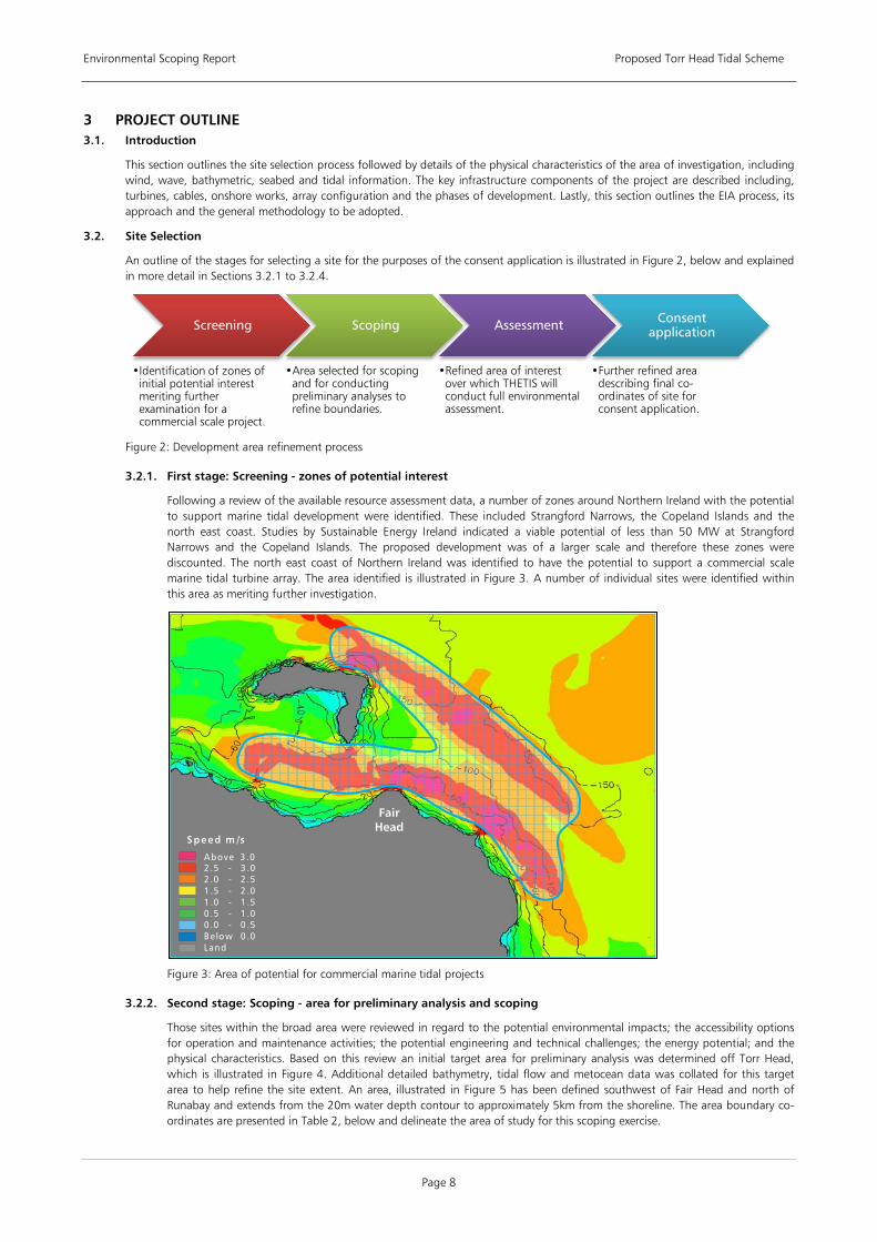
An outline of the stages for selecting a site for the purposes of the consent application is illustrated in Figure 2, below and explained in more detail in Sections 3.2.1 to 3.2.4.
Figure 2: Development area refinement process
3.2.1. First stage: Screening - zones of potential interest
Following a review of the available resource assessment data, a number of zones around Northern Ireland with the potential to support marine tidal development were identified. These included Strangford Narrows, the Copeland Islands and the north east coast. Studies by Sustainable Energy Ireland indicated a viable potential of less than 50 MW at Strangford Narrows and the Copeland Islands. The proposed development was of a larger scale and therefore these zones were discounted. The north east coast of Northern Ireland was identified to have the potential to support a commercial scale marine tidal turbine array. The area identified is illustrated in Figure 3. A number of individual sites were identified within this area as meriting further investigation.
Figure 3: Area of potential for commercial marine tidal projects
3.2.2. Second stage: Scoping - area for preliminary analysis and scoping
Those sites within the broad area were reviewed in regard to the potential environmental impacts; the accessibility options for operation and maintenance activities; the potential engineering and technical challenges; the energy potential; and the physical characteristics. Based on this review an initial target area for preliminary analysis was determined off Torr Head, which is illustrated in Figure 4. Additional detailed bathymetry, tidal flow and metocean data was collated for this target area to help refine the site extent. An area, illustrated in Figure 5 has been defined southwest of Fair Head and north of Runabay and extends from the 20m water depth contour to approximately 5km from the shoreline. The area boundary co-ordinates are presented in Table 2, below and delineate the area of study for this scoping exercise.
Screening
•Identification of zones of initial potential interest meriting further examination for a commercial scale project.
Scoping
•Area selected for scoping and for conducting preliminary analyses to refine boundaries.
Assessment
•Refined area of interest over which THETIS will conduct full environmental assessment.
Consent application
•Further refined area describing final co-ordinates of site for consent application.
Above 3 .02 .5 - 3 .02 .0 - 2 .51 .5 - 2 .01 .0 - 1 .50 .5 - 1 .00 .0 - 0 .5Be low 0 .0Land
Speed m /s
Fair Head

Environmental Scoping Report Proposed Torr Head Tidal Scheme
Page 9
Figure 4: Initial area for preliminary analysis and scoping
Figure 5: Final area for preliminary analysis and scoping
Point Longitude Latitude
A 6º06`00``W 53º12`30``N
Above 3 .02 .5 - 3 .02 .0 - 2 .51 .5 - 2 .01 .0 - 1 .50 .5 - 1 .00 .0 - 0 .5Be low 0 .0Land
Speed m /s
Environmental Scoping Report Proposed Torr Head Tidal Scheme
Page 10
B 6º02`00``W 55º14`00``N
C 6º00`00``W 55º13`30``N
D 6º00`00``W 55º11`00``N
Table 2: Co-ordinates of final area for preliminary analysis and scoping
3.2.3. Third stage: Assessment - area for environmental assessment studies
The results of the scoping exercise in stage 2 outlined above will determine the area over which EIA baseline survey and conceptual engineering design studies will be conducted. These studies will enable THETIS Energy Ltd to determine the proposed project details including the turbine array configuration, the nature and number of turbines and the proposed final site boundary co-ordinates.
3.2.4. Fourth stage: Consent application - final area for consent application
The project details from stage 3 outlined above will be used to draft the Environmental Statement which will support the applications for Article 39 consent and FEPA licensing. It should be recognised that the final site area will be a smaller area than the area of interest for scoping. For approximation purposes, a project of 150 MW might be contained within an area of 2.5 km2, compared with the area of approximately 34 km2 identified in the scoping process (Figure 5). The actual footprint of the tidal turbines themselves will occupy a seabed area of approximately 0.015 km2 or less than 0.05 % of the area shown in Figure 5.
3.3. Physical Site Description
This section describes the physical characteristics of the area of investigation.
3.3.1. Tidal Conditions
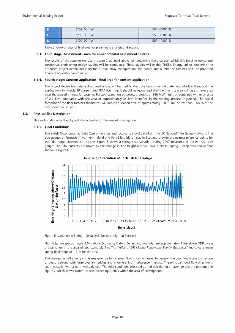
The British Oceanographic Data Centre monitors and records sea level data from the UK National Tide Gauge Network. The tide gauges at Portrush in Northern Ireland and Port Ellen, Isle of Islay in Scotland provide the nearest reference points for the tidal range expected on the site. Figure 6 shows a spring neap variation during 2007 measured at the Portrush tide gauge. The tidal currents are driven by the change in tide height and will have a similar spring – neap variation as that shown in Figure 6.
Figure 6: Variation in Spring – Neap cycle for tide height at Portrush
High tides are approximately 3.5m above Ordinance Datum Belfast and low tides are approximately 1.5m above ODB giving a tidal range in the area of approximately 2m. The “Atlas of UK Marine Renewable Energy Resources” indicates a mean spring tidal range of 1-2 m for the area.
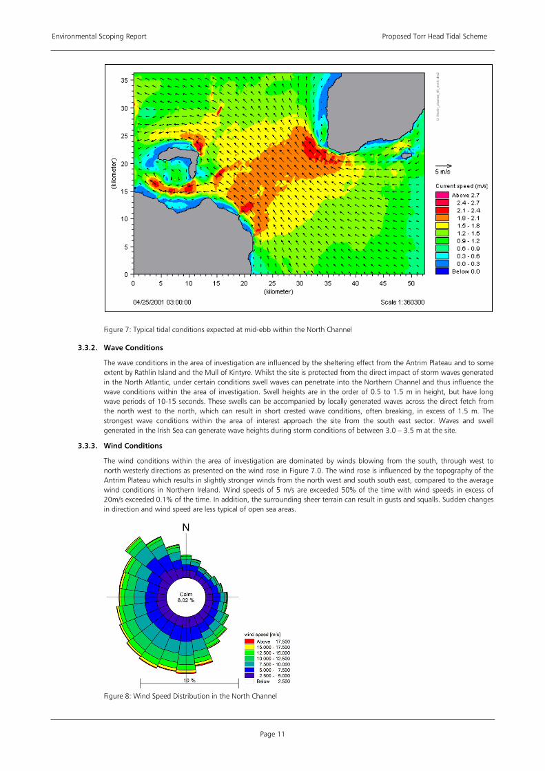
The changes in bathymetry in the area give rise to increased flow in certain areas. In general, the tidal flow along this section of coast is strong with large overfalls, eddies and in general high turbulence intensity. The principal flood flow direction is south easterly, with a north westerly ebb. The tidal conditions expected at mid ebb during an average tide are presented in Figure 7 which shows current speeds exceeding 2.7m/s within the area of investigation
Environmental Scoping Report Proposed Torr Head Tidal Scheme
Page 11
Figure 7: Typical tidal conditions expected at mid-ebb within the North Channel
3.3.2. Wave Conditions
The wave conditions in the area of investigation are influenced by the sheltering effect from the Antrim Plateau and to some extent by Rathlin Island and the Mull of Kintyre. Whilst the site is protected from the direct impact of storm waves generated in the North Atlantic, under certain conditions swell waves can penetrate into the Northern Channel and thus influence the wave conditions within the area of investigation. Swell heights are in the order of 0.5 to 1.5 m in height, but have long wave periods of 10-15 seconds. These swells can be accompanied by locally generated waves across the direct fetch from the north west to the north, which can result in short crested wave conditions, often breaking, in excess of 1.5 m. The strongest wave conditions within the area of interest approach the site from the south east sector. Waves and swell generated in the Irish Sea can generate wave heights during storm conditions of between 3.0 – 3.5 m at the site.
3.3.3. Wind Conditions
The wind conditions within the area of investigation are dominated by winds blowing from the south, through west to north westerly directions as presented on the wind rose in Figure 7.0. The wind rose is influenced by the topography of the Antrim Plateau which results in slightly stronger winds from the north west and south south east, compared to the average wind conditions in Northern Ireland. Wind speeds of 5 m/s are exceeded 50% of the time with wind speeds in excess of 20m/s exceeded 0.1% of the time. In addition, the surrounding sheer terrain can result in gusts and squalls. Sudden changes in direction and wind speed are less typical of open sea areas.
Figure 8: Wind Speed Distribution in the North Channel

Environmental Scoping Report Proposed Torr Head Tidal Scheme
Page 12
3.3.4. Bathymetry
The water depth in the area of investigation varies from less than 10m Chart Datum (CD) in the near shore to approximately 120m CD at its seaward limit (see Figure 5, above). The seabed shelves steeply from the shoreline with general water depth falling from less than 10 m to in excess of 50 m within 800m from the shoreline. Around half of the area of investigation is within 50 to 100 m water depth (see Figure 9). There are other areas further offshore where the seabed rises and these features give rise to the variation in flow conditions and increase in the tidal currents that can be harnessed to generate electricity.
Figure 9: Bathymetry of region
3.3.5. Seabed Conditions
Evidence from Admiralty Charts coupled with knowledge of the strong tidal current regime suggests that the seabed within the area of investigation is dominated by coarse material comprising boulders and cobbles. Fine sediments would tend to be transported away from the site due to the high energy associated with the tidal currents and would therefore be restricted to the shoreline or other localised areas of shelter caused by depressions or at the base of large boulders. RoxAnn surveys, described in the Section 5.4, also concur with the above description of the seabed morphology.
Data Source • ABPmer Ltd (2004) Atlas of UK Marine Renewable Energy Resources”, report for the Department of Trade & Industry,
ABP Marine Environmental Research Ltd. December 2004 • Admiralty Charts • British Oceanographic Data Centre https://www.bodc.ac.uk/data/online_delivery/ntslf/ • Joint Irish Bathymetric Survey http://www.spatial.dcenr.gov.ie/imf/imf.jsp?site=JIBS
3.4. Project Description
3.4.1. Turbine Units
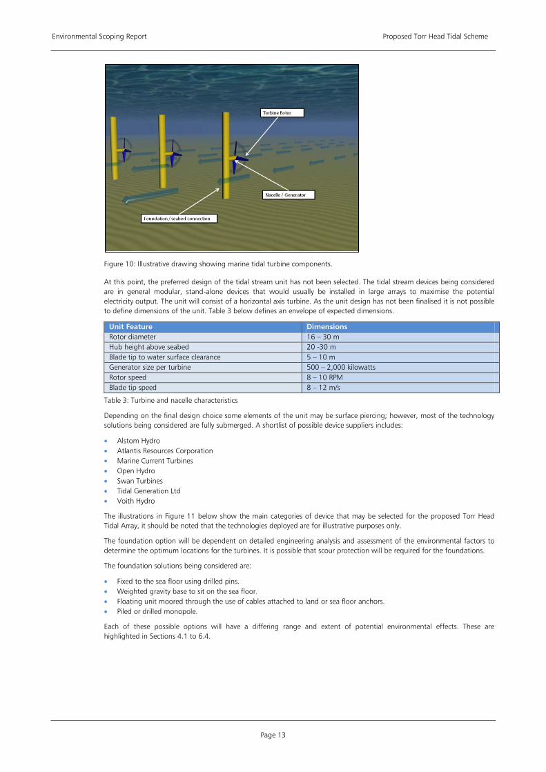
Tidal stream technologies work by extracting some of the kinetic energy from fast-flowing tidal currents and converting that kinetic energy to electricity. Underwater turbines generate electricity in a similar manner to wind turbine technology (se conceptual illustration in Figure 10), however due to the dense nature of water significant power is generated from relatively small turbine diameters and at lower flow speeds.
Environmental Scoping Report Proposed Torr Head Tidal Scheme
Page 13
Figure 10: Illustrative drawing showing marine tidal turbine components.
At this point, the preferred design of the tidal stream unit has not been selected. The tidal stream devices being considered are in general modular, stand-alone devices that would usually be installed in large arrays to maximise the potential electricity output. The unit will consist of a horizontal axis turbine. As the unit design has not been finalised it is not possible to define dimensions of the unit. Table 3 below defines an envelope of expected dimensions.
Unit Feature Dimensions Rotor diameter 16 – 30 m Hub height above seabed 20 -30 m Blade tip to water surface clearance 5 – 10 m Generator size per turbine 500 – 2,000 kilowatts Rotor speed 8 – 10 RPM Blade tip speed 8 – 12 m/s
Table 3: Turbine and nacelle characteristics
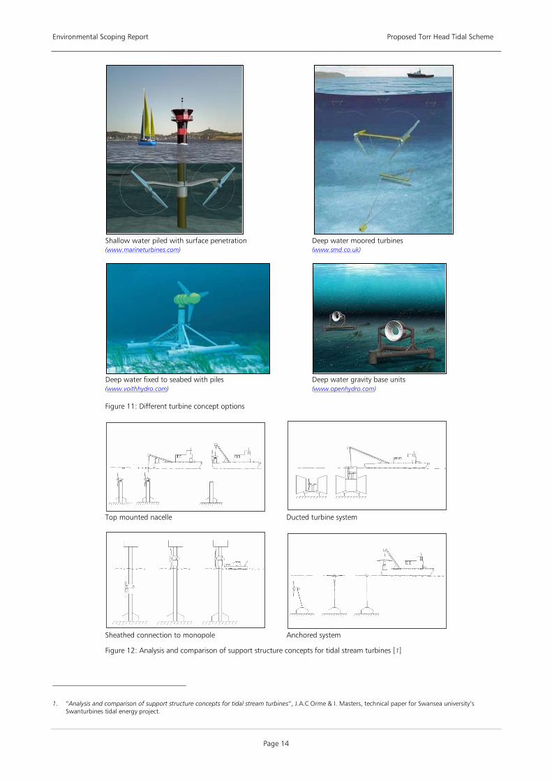
Depending on the final design choice some elements of the unit may be surface piercing; however, most of the technology solutions being considered are fully submerged. A shortlist of possible device suppliers includes:
• Alstom Hydro • Atlantis Resources Corporation • Marine Current Turbines • Open Hydro • Swan Turbines • Tidal Generation Ltd • Voith Hydro
The illustrations in Figure 11 below show the main categories of device that may be selected for the proposed Torr Head Tidal Array, it should be noted that the technologies deployed are for illustrative purposes only.
The foundation option will be dependent on detailed engineering analysis and assessment of the environmental factors to determine the optimum locations for the turbines. It is possible that scour protection will be required for the foundations.
The foundation solutions being considered are:
• Fixed to the sea floor using drilled pins. • Weighted gravity base to sit on the sea floor. • Floating unit moored through the use of cables attached to land or sea floor anchors. • Piled or drilled monopole.
Each of these possible options will have a differing range and extent of potential environmental effects. These are highlighted in Sections 4.1 to 6.4.
Environmental Scoping Report Proposed Torr Head Tidal Scheme
Page 14
Shallow water piled with surface penetration (www.marineturbines.com)
Deep water moored turbines (www.smd.co.uk)
Deep water fixed to seabed with piles (www.voithhydro.com)
Deep water gravity base units (www.openhydro.com)
Figure 11: Different turbine concept options
Top mounted nacelle Ducted turbine system
Sheathed connection to monopole Anchored system
Figure 12: Analysis and comparison of support structure concepts for tidal stream turbines [1
]
1. “Analysis and comparison of support structure concepts for tidal stream turbines”, J.A.C Orme & I. Masters, technical paper for Swansea university’s
Swanturbines tidal energy project.
Environmental Scoping Report Proposed Torr Head Tidal Scheme
Page 15
3.4.2. Cables and offshore substation
Power cables are likely to be 3 core cables consisting of copper conductors, insulation and steel armour, rated at 33kV, contained in a sleeve of polypropylene with a diameter of 140mm; a fibre optic communications cable will be included for control purposes. It is likely that network of cables will connect the separate turbine arrays to an offshore substation, housing the switch gear, transformers and other electrical equipment (see Figure 13). A central cabling system will connect to the onshore sub-station. Depending on seabed conditions, the cables between turbine locations and cable landfall will either be buried or surface laid with armouring to protect them.
3.4.3. Onshore Works
The main onshore works will comprise an unmanned building containing equipment for communications and controls for the connection of the offshore transmission cables to the onshore electrical transmission network. At this point, the locations of the cable landfall and the onshore substation have not been defined. It is anticipated that these locations will be determined through consultations with Northern Ireland Electricity (NIE) and other key stakeholders. A number of factors will influence these locations, including engineering, environmental and economic effects associated with each potential site. Key aspects of this process will be to examine length of both onshore and offshore cabling required, proximity to grid connection, methods of bringing cable ashore in the inter-tidal zone, access to work site, effects on coastal defences and processes, impacts on nature conservation designations, sensitive species and impacts upon local amenity.
Works in respect of the proposed tidal scheme will terminate at the project substation. Works connecting the substation to the existing NIE system will be the subject of a separate EIA and a separate planning application by NIE. This application will also be subject to Article 40 consent requirements of the Electricity Order 1992.
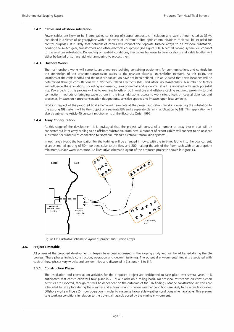
3.4.4. Array Configuration
At this stage of the development it is envisaged that the project will consist of a number of array blocks that will be connected via inter-array cabling to an offshore substation. From here, a number of export cables will connect to an onshore substation for subsequent connection to Northern Ireland’s electrical transmission systems.
In each array block, the foundation for the turbines will be arranged in rows, with the turbines facing into the tidal current, at an estimated spacing of 50m perpendicular to the flow and 200m along the axis of the flow, each with an appropriate minimum surface water clearance. An illustrative schematic layout of the proposed project is shown in Figure 13.
Figure 13: Illustrative schematic layout of project and turbine arrays
3.5. Project Timetable
All phases of the proposed development’s lifespan have been addressed in the scoping study and will be addressed during the EIA process. These phases include construction, operation and decommissioning. The potential environmental impacts associated with each of these phases vary widely, and are identified and discussed in Sections 4.1 to 6.4.
3.5.1. Construction Phase
The installation and construction activities for the proposed project are anticipated to take place over several years. It is anticipated that construction will take place in 20 MW blocks on a rolling basis. No seasonal restrictions on construction activities are expected, though this will be dependent on the outcome of the EIA findings. Marine construction activities are scheduled to take place during the summer and autumn months, when weather conditions are likely to be more favourable. Offshore works will be a 24 hour operation in order to maximise favourable weather conditions when available. This ensures safe working conditions in relation to the potential hazards posed by the marine environment.
Environmental Scoping Report Proposed Torr Head Tidal Scheme
Page 16
The project will involve transport of a large quantity of materials and turbine components to the offshore site from port. The nearest construction port with the capacity to load component parts and mobilise vessels used in construction is Belfast. This port is in close proximity to Harland and Wolff (http://www.harland-wolff.com/home.asp), a well established fabrication yard for the renewables industry. It was previously used to produce and mobilise MCT’s Strangford Lough project. Smaller vessels used for personnel transfer etc can mobilise out of smaller local ports.
A number of vessels including a jack-up or moored barge, a floating crane barge, cable laying vessels, tugs and safety vessels will be required during the construction phase, for activities such as drilling, piling and erection of the turbines and cable laying.
All construction work will be carried out in accordance with an appropriate safety assessment that will determine the requirement for any navigational restrictions. Full consideration will be given to shipping and navigation interests under the Marine Guidance Note (MGN) 371 on Offshore Renewable Energy Installations (OREI).
The Commissioners of Irish Lights, as the statutory Lighthouse Authority for Ireland will specify the required marking and lighting of tidal devices, during construction and subsequent operational phases, which will be conveyed to the UK Hydrographic Office to be incorporated into Admiralty Charts and Notice to Mariners procedures. The construction area may also be marked using temporary buoys around the site perimeter, the need for which will be considered as part of the Navigational Risk Assessment (NRA) undertaken as part of the EIA.
Depending on the design of the turbine unit and foundations, some spoil may be produced and solid discharges into the marine environment may occur during the construction stages. There is also a small risk of accidental discharges from vessels or turbine units.
Health and Safety is a key consideration of a project. As such, marine construction plant specifications shall include proven capability for use in the environmental conditions expected within the area of investigation, as well as consideration of its initial integrity, the suitability for the work which is intended and potential hazards it may create by its use. All equipment shall be assessed to ensure compliance with HSE regulation and guidance, manufactured to agreed European Safety Standards and when applicable shall meet specific marine regulation and guidance. Job specific risk assessment and method statements shall be undertaken for all marine operations including consideration to the specific marine plant to be used. Protocols will be established in advance of the construction works with respect to safe working practices.
An environmental management system will be specified, agreed with the competent statutory authorities and enforced on site. The documentation will ensure compliance with any consent conditions and current environmental best practice, and is likely to include the following elements:
• Environmental management plan; • Environmental monitoring protocol ; • Incident reporting and non-conformance procedure; • Emergency response plan; • Marine pollution contingency plan; • Dropped objects and materials recovery plan; • Archaeology response plan; • Noise, dust and vibration management plan; and, • Waste management plan.
3.5.2. Operational Phase
The operational lifespan of the proposed project is 20 to 25 years. As each 20MW block is commissioned it is likely to be subject to 8-12 weeks of testing for the turbine, electrical and foundation sub-systems. Following this, approximately 6 months of testing to validate and optimise performance will be undertaken. This may involve the deployment of Acoustic Doppler Current Profiling (ADCP) meters to measure the flow characteristics near to the turbine units. Similar performance analysis may be undertaken from time to time, usually over a 6 months period, throughout the operational phase of the development.
Routine operation and maintenance activities will continue all year round and access to the site is required at all times. The turbine units will be serviced and maintained throughout the service life of the array from a local operations port. Operation and maintenance activities will include:
• Periodic overhauls carried out in accordance with the turbine manufacturer’s warranty. These tasks will be planned for periods of the year with the most favourable access conditions, most likely during summer months.
• Scheduled maintenance involving inspections and work on high wear parts susceptible to deterioration in between periodic overhauls. These activities are likely to involve a small workboat operated from a local port, with small support vessels if required.
• Unscheduled maintenance is reactive to any sudden defects or component failure. These activities are likely to require the intervention of the vessels used during the construction phases.
• Inspections of the subsea cables and support structures will be performed on a regular basis, along with ad hoc visits for surveillance purposes.
As with the construction phase a project EMS for the operational phase will include:
Environmental Scoping Report Proposed Torr Head Tidal Scheme
Page 17
• Environmental management plan; • Environmental monitoring protocol; • Incident reporting and non-compliance procedure; • Emergency response plan; • Marine pollution contingency plan; • Dropped objects and materials recovery plan; • Noise, dust and vibration management plan; and, • Waste management plan.
3.5.3. Decommissioning Phase
The Energy Act 2004 introduced a statutory decommissioning scheme for offshore wind and marine energy installations that were strengthened by the Energy Act 2008. It is recognised that the decommissioning phase needs to be considered at an early stage, alongside other key project activities. Decommissioning of the proposed project is included in this scoping phase and will be addressed in the EIA.
The objectives of decommissioning are to minimise both the short and long term effects on the environment whilst making the sea safe for others to navigate. Based on current regulations and available technology, the following decommissioning method is proposed:
• Isolate the tidal turbine units from the electricity grid. • Complete removal of tidal turbine units – using a reversal of the installation process. • Foundation structures and sub-structures to be removed to the natural seabed level. • Export cables to be left in-situ, buried to below the natural seabed level or covered by rock-dumping. • Cable shore landing to be either left in-situ or safely removed. • Scour protection to be left in-situ. • Onshore cabling to be left in-situ if buried or safely removed if above ground. • Onshore grid connection equipment to be safely removed. • Onshore buildings to be either converted to alternative uses, subject to planning, or removed.
It is anticipated that access to site during the decommissioning phase will be similar to those required for the construction phase.
The ES will contain a brief description of the following:
• Outline method statement for the decommissioning process for all types of infrastructure cited in the project description.
• Details of possible methods of removal and likelihood of re-use or recycling of components. • Details of possible methods of disposal for products where re-use or recycling is not anticipated. • Decommissioning programme.
The scope and duration of the monitoring requirements post decommissioning will be agreed in consultation with the statutory consultees and details will be included in the decommissioning programme.
3.6. Environmental Impact Assessment Approach and Methodology
At present the exact details of the tidal turbine device to be used, the exact location and configuration of the array, cable routes and cable landfall are not yet finalised and will be informed by the survey work which is planned to establish the baseline conditions, as discussed in Sections 4.1 to 6.4.
3.6.1. Rochdale Principle
There are certain challenges associated with carrying out EIA on a project where designs have not been finalised. In particular an EIA which fails to fully appraise a project may give rise to the grant of a consent which may be contrary to planning law. This was the situation considered in the cases of R v Rochdale Metropolitan Borough Council ex p Milne (2000) and R v Rochdale Metropolitan Borough Council ex p Tew (1999) which, although considered under English law, provide a useful guide to the operation of the EIA Directive and Northern Irish regulations. Following these cases an approach known as the "Rochdale principle" has become established in order to provide for the EIA of projects, such as outline planning permissions, where full details of the project's design are not available.
The Rochdale principle has been subsequently successfully applied to most marine renewable energy projects, including all of the UK's Round 2 wind farms. The approach is based on assessing the potential impacts of a "realistic worst case scenario", under which the assessment of the project is defined by an "envelope" of theoretical constraints. For example, although the design of the onshore substation is currently unknown its "envelope" can be defined by a maximum footprint (length and width) in respect of land-take or a maximum height in respect of visual intrusion. In this way the design of the scheme can vary within these maximum parameters without rendering the EIA findings invalid. Any subsequent consent would incorporate these parameters into its conditions; thereby ensuring that the scheme consented is that which has been assessed under EIA.
Environmental Scoping Report Proposed Torr Head Tidal Scheme
Page 18
It is intended that where details of the scheme cannot be finalised ahead of the submission of the environmental statement the Rochdale principle may be applied. The details of the relevant envelope will be agreed with key stakeholders and regulators as part of the ongoing consultation process.
3.6.2. Basis for EIA
The EIA will be undertaken based on the following steps:
• Consideration of the need for project and alternatives for meeting this need. • Site selection process. • Scoping. This process determines the potentially significant effects that require assessment and how this assessment
should be carried out. • Ongoing consultation with statutory consultees over the scope of the EIA in particular the scope of survey work to be
undertaken and the regulatory requirements in regard to Appropriate Assessment. • Undertake a baseline assessment of the existing environment and determine any sensitive receptors. (The recommended
steps required to establish the baseline are outlined in Sections 4.1 to 6.4 and Appendix 1). • Based on results of baseline survey work, confirm the project definition. This will inform the impact assessment work. • Impact assessment to define the scale of predicted environmental effects in terms of significance. • Identification of measures to mitigate those effects which are significant. • Evaluation of significance of predicted effects, spatially and temporally after the application of mitigation measures. • Collation of findings into an ES.
3.6.3. EIA Impact Assessment Topics and Approach
The key topic areas the EIA will address during the impact assessment are as follows:
• Ornithology • Large Marine Species (cetaceans, seals and turtles) • Benthic and inter-tidal ecology • Terrestrial ecology • Fish and Shellfish ecology • Commercial fisheries; • Shipping and navigation; • Landscape and Seascape; • Socio-economic impacts including recreation and tourism • Archaeology and cultural heritage • Geology • Coastal processes • Water quality and suspended sediments • Noise • Onshore works
Each topic will be addressed individually and the results presented in the relevant section. However, there will be collaboration between specialists to ensure that the wider environmental effects are considered. For example the results of the coastal processes modelling will feed into the assessment of the proposed projects effect on benthic ecology.
Where practicable, the same approach to impact assessment will be applied to each topic and structured using a consistent format. The following format will be used:
1) Introduction
2) Statement of authority of the topic author.
3) Assessment Methodology. This will include details of data sources; site visits consultation undertaken and subsequent responses; baseline survey methodology (both desk based and field based) including relevant guidance; definitions of significance criteria; and a note of any difficulties (technical deficiencies or data gaps) encountered in conducting the environmental assessment.
4) Existing conditions to include a description of baseline conditions, the identification of any sensitive receptors and any survey results where appropriate.
5) Assessment of Construction Impacts. This will include details of all pre-mitigation impacts (direct, indirect and in-combination) and their significance, a description of proposed mitigation measures, residual impacts and their significance and any cumulative impacts.
6) Assessment of Operational Impacts. This will include details of all pre-mitigation impacts (direct, indirect and in-combination) and their significance, a description of proposed mitigation measures, residual impacts and their significance and any cumulative impacts.
7) Assessment of decommissioning Impacts. Where appropriate this will include details of all pre-mitigation impacts (direct, indirect and in-combination) and their significance, a description of proposed mitigation measures, residual impacts and their significance and any cumulative impacts.
Environmental Scoping Report Proposed Torr Head Tidal Scheme
Page 19
8) Future situation without the scheme, to give an indication of what the existing conditions would be without the scheme.
9) Future monitoring requirements to which THETIS are committed.
10) An overall conclusion providing a synopsis of the impact assessment and how each individual issue or receptor will be affected by the proposed development.
11) A summary providing a balanced statement of the key information and conclusions of the assessment.
12) References.
3.6.4. EIA Outputs
An Environmental Statement (ES) will be prepared to report all the findings of the EIA work undertaken. The ES will support the Article 39 consent application to DETI, the Section 5 FEPA Licence application to DoENI and the planning application to the Planning Service of Northern Ireland if required for onshore works. It is envisaged that the ES will comprise four volumes. These are:
• Volume 1: A non-technical summary of the information contained in Volumes 2, 3 and 4. • Volume 2: The full text of the Torr Head Tidal Scheme Environmental Statement Final Report. • Volume 3: The figures accompanying the text in Volume 2. • Volume 4: Appendices covering technical issues in the Environmental Statement.
The format and chapter headings of Volume 2 (the main report) are set out in Appendix 4, and will comprise sections covering the following issues:
• An introduction to the environmental statement and will present summary reviews of the project, the statutory requirements and the structure of the environmental statement itself.
• A review of the scoping consultation process and the impact assessment methodological approach used for the studies. Any significant difficulties encountered in the preparation of the statement will be identified.
• An overview of the policy framework against which the project is being proposed. This will include a review of European, national and local policy and legislative developments relevant to a marine tidal project. This section will assess the need for the project and detail the statutory planning guidance relevant to the project.
• Details of the proposed site for the project and the surrounding area. This will include a description of the seascape/landscape setting; any relevant statutory designations; the principal settlements and infrastructure; and existing uses of the site.
• Details of the proposed tidal energy scheme and the project proposers. This will provide details of the purpose and objectives of the scheme. It will set out the nature and scale of the project including technology and layout design information. Other infrastructure details will be described including cabling, substation requirements and onshore grid interconnection arrangements. The section will describe the construction phase activities and programme; the operation and maintenance strategies and requirements; and the decommissioning activities and requirements.
• An assessment of alternative technologies and turbine options. It will provide details of the site assessment process and the main reasons for the choice of this site. It will describe the design evolution process shaping nature, location and scale of the project as a result of the requirements to mitigate any significant environmental impacts.
• Consideration of the environmental impact of the proposed project broken down by each issue identified in Section 3.6.3.
• A description of the proposed public information programme [2• A summary of the mitigation measures and their effectiveness
].
• An overall conclusion as to the results of the environmental impact assessment.
3.6.5. EIA Guidance
A number of general guidance documents have been identified in relation undertaking an EIA and applying for consent for the development of a marine tidal turbine array in the UK. Some new guidance is currently being developed by the European Marine Energy Centre (EMEC) to specifically target the needs of the marine energy industry. These EMEC documents have been noted below. However, due to the novel nature of the technology there is often an absence of specific and established guidance relating to tidal turbine projects. As such, THETIS will refer and use the guidance published by the British Wind Energy Association (BWEA) documents originally developed for the offshore wind farm industry, but now being adopted by the emerging wave and tidal sector. These guidance documents will be referred to as appropriate throughout the EIA process, the construction, the operation and the decommissioning of the tidal array.
Relevant Guidance Documents • Best Practice Guidelines – Consultation for Offshore Wind Energy Developments, 2002
• BWEA Best Practice Guidelines for Wind Energy Development, November 1994, recently revised
• BWEA Guidelines for Health and Safety in the Marine Energy Industry 2008
• BWEA Health and Safety Guidelines, 2002
2. The statement of the proposed public information programme is supplementary to the requirements of the environmental assessment itself and is provided
for information purposes.

Environmental Scoping Report Proposed Torr Head Tidal Scheme
Page 20
• CEFAS. 2004. Guidance notes for Environmental Impact Assessment in respect of FEPA/CPA requirements. (Version 2 - June 2004
• Defra (2005). Nature Conservation Guidance on Offshore Wind Farm Development - A guidance note on the implications of the EC Wild Birds and Habitats Directives for developers undertaking offshore wind farm developments.
• DTI (2006) Decommissioning of offshore renewable energy installations under the Energy Act 2004
• Guidelines for Environmental Appraisal in the Marine Energy Industry – this guidance is currently being developed by EMEC
• Guidelines for Project Development in the Marine Energy Industry Marine Renewable Energy Guides The European Marine Energy Centre Ltd 2009
• Guidelines for Reliability, Maintainability and Survivability of Marine Energy Conversion Systems. The European Marine Energy Centre Ltd 2009
• IEEM (2009) Guidelines for Ecological Impact Assessment in Britain and Ireland – Marine and Coastal. Institute of Ecology and Environmental Management Consultation Document.
• Preparation of Environmental Statements for Planning Projects that Require Environmental Assessment (DoE, 1995) Guidance Notes, Offshore Wind Farm Consents Process, DTI, January 2003, updated August 2004
Subject specific guidance documents, for example in relation to marine archaeology, are referred to under the relevant topics in Sections 4.1 to 6.4.

Environmental Scoping Report Proposed Torr Head Tidal Scheme
Page 21
4 PHYSICAL ENVIRONMENT
This section summarises the potential effects and impacts of the development on the following physical aspects of the environment including geology, coastal processes, water quality and suspended sediments and noise. Key work items for establishing baseline information are identified, including both desk based reviews and additional survey work required. Important issues to be addressed in the impact assessment are outlined and recommendations are made regarding necessary consultations and guidance documents that may be of relevance.
4.1.
4.1.1. Current Knowledge
COASTAL PROCESSES
As can be seen below in Figure 14, the high tidal currents (spring peak flow 1.75 to >3 m/s, APBmer Atlas) within the area of interest coupled with its exposure to storm waves has resulted in a seabed morphology which in mostly devoid of fine sediments, with only coarse sediments being apparent offshore. Inshore, mixed sediment exist and there are coastal areas of sand and muddy sand to the west of the site and on the south side of Rathlin Island which could be impacted upon if the hydrodynamic regime changes. A characterisation of the context for the coastal processes assessment is provided in Section 3.3.
Figure 14: Seabed Sediments (OneGeology website, 2009)
Data Source • Atlas of UK Marine Renewable Resources at http://www.renewables-atlas.info/ Accessed 01/08/09) • OneGeology website ( http://www.onegeology.org/). Accessed 01/08/09
4.1.2. Potential Effects
The proposed site is approximately 8 km from the Rathlin Island SAC, designated for a number of marine and coastal features including Annex I reefs and sandbanks. Any changes in the hydrodynamic regime will need to be considered in respect of these features.
• Construction The installation and construction of the proposed 100 turbines is likely to have an impact on the hydrodynamic
regime in the local area sedimentary regime, possibly including SAC features. The significance of this impact will need to be assessed in the EIA.
• Operation

Environmental Scoping Report Proposed Torr Head Tidal Scheme
Page 22
Localised scouring around the base of the tidal turbine units may cause a loss of benthic habitat or smother the existing habitat due to deepening of seabed. The degree of scour will be dependent upon the final choice of foundation design.
Installation of tidal turbine units may affect the wave regime and the tidal current regime. This may have impact on benthic communities and has the potential to cause effects further afield in respect of sediment transport on beaches, possible dune features and SAC coastal features.
• Decommissioning The removal of 100 turbines may cause a change to the hydrodynamic regime and coastal processes of the local
area and is likely to lead to a return to conditions that existed prior to installation. Foundation type will influence decommissioning methods and, once defined, the extent of impacts can be assessed.
In general, it should be noted that the physical conditions expected within the area of investigation are likely to make construction works including the deployment of the array of tidal energy devices and later decommissioning of the works difficult thereby increasing both the risk of discharge of pollutants (such as lubricants) during the works or operation or the loss of equipment. This would be considered as part of the EIA process and subsequent Project Environment Plan.
4.1.3. Scope of Establishing Baseline
The baseline nature of the physical conditions (bathymetry, coastal processes, geology and metocean) within the area of investigation must be accurately quantified to allow for a construction plan to be designed which will minimise the potential risks outlined above. The following key work items are required to inform the baseline.
• Desk based review Undertake a review of relevant national, regional and local policies affecting the protection and conservation of
coastal waters.
Identification of features sensitive to changes in coastal processes e.g. bathing beaches, dune systems etc, SAC coastal features.
Data screening exercise to asses existing datasets for baseline definition and complete a gap analysis. Data types required include:
Bathymetric (e.g. Admiralty chart / SeaZone data) Coastal processes (including net sediment transport) Geology (e.g. BGS) Metocean (e.g. British Oceanographic Data Centre (BODC) datasets and meteorological datasets
(MetOffice).
• Survey and modelling work Detailed site specific survey work of the proposed area will need to be undertaken to fill data / information gaps
and provide baseline data. Data will be required on the tidal regime, current flows, wave climate, meteorology, temperature, salinity and suspended sediment concentrations (See Section 4.3 Water Quality and Suspended Sediments).
Computational models will be developed, calibrated and validated using data from the programme of fieldwork to determine the physical conditions across the area of investigation. It is envisaged that both 2D and 3D computational modelling will be undertaken to define the physical conditions of the potential development area and in close proximity to the tidal turbine structures and for the proposed cable corridor.
• Consultation will be required with NIEA to assess the possible impacts on the Rathlin Island SAC features and the data requirements of any potential Appropriate Assessment under the Habitats Regulations.
4.1.4. Impact Assessment
The impact assessment will be undertaken by a suitability qualified specialist(s) with hydrodynamic and coastal processes modelling capability. The detailed scope of the modelling will be agreed with the NIEA in due course. The coastal processes and geomorphological impact assessment will be carried out to address the following issues:
1) Information generated from the coastal processes study will be used to facilitate the selection of the tidal energy device(s), the design of the foundations, the design of array and export cables and the design of the construction programme of works.
2) The results of the coastal processes study, including hydrodynamic and geomorphological modelling will be used to estimate the extent of potential scouring around the foundations.
3) In conjunction with ecological baseline data, potential impacts on the biological environment for all stages of the project lifecycle can be assessed (e.g. on benthic communities and fisheries).
4) The results will also be used to estimate the magnitude of the impacts the array of tidal energy devices could have on the region’s coastal processes, particularly on designated bathing waters, dune systems and other sensitive habitats including SAC coastal features.
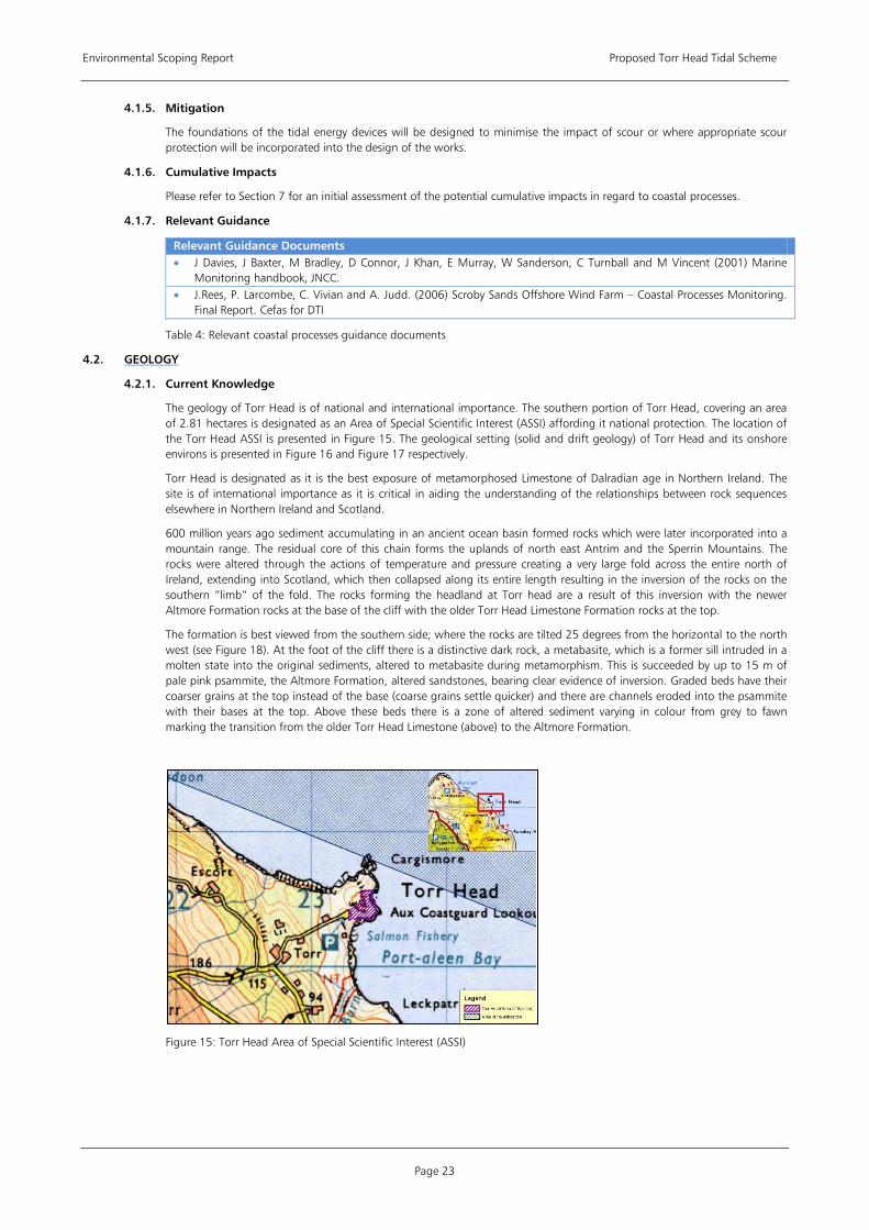
Environmental Scoping Report Proposed Torr Head Tidal Scheme
Page 23
4.1.5. Mitigation
The foundations of the tidal energy devices will be designed to minimise the impact of scour or where appropriate scour protection will be incorporated into the design of the works.
4.1.6. Cumulative Impacts
Please refer to Section 7 for an initial assessment of the potential cumulative impacts in regard to coastal processes.
4.1.7. Relevant Guidance
Relevant Guidance Documents • J Davies, J Baxter, M Bradley, D Connor, J Khan, E Murray, W Sanderson, C Turnball and M Vincent (2001) Marine
Monitoring handbook, JNCC. • J.Rees, P. Larcombe, C. Vivian and A. Judd. (2006) Scroby Sands Offshore Wind Farm – Coastal Processes Monitoring.
Final Report. Cefas for DTI
Table 4: Relevant coastal processes guidance documents
4.2.
4.2.1. Current Knowledge
GEOLOGY
The geology of Torr Head is of national and international importance. The southern portion of Torr Head, covering an area of 2.81 hectares is designated as an Area of Special Scientific Interest (ASSI) affording it national protection. The location of the Torr Head ASSI is presented in Figure 15. The geological setting (solid and drift geology) of Torr Head and its onshore environs is presented in Figure 16 and Figure 17 respectively.
Torr Head is designated as it is the best exposure of metamorphosed Limestone of Dalradian age in Northern Ireland. The site is of international importance as it is critical in aiding the understanding of the relationships between rock sequences elsewhere in Northern Ireland and Scotland.
600 million years ago sediment accumulating in an ancient ocean basin formed rocks which were later incorporated into a mountain range. The residual core of this chain forms the uplands of north east Antrim and the Sperrin Mountains. The rocks were altered through the actions of temperature and pressure creating a very large fold across the entire north of Ireland, extending into Scotland, which then collapsed along its entire length resulting in the inversion of the rocks on the southern “limb” of the fold. The rocks forming the headland at Torr head are a result of this inversion with the newer Altmore Formation rocks at the base of the cliff with the older Torr Head Limestone Formation rocks at the top.
The formation is best viewed from the southern side; where the rocks are tilted 25 degrees from the horizontal to the north west (see Figure 18). At the foot of the cliff there is a distinctive dark rock, a metabasite, which is a former sill intruded in a molten state into the original sediments, altered to metabasite during metamorphism. This is succeeded by up to 15 m of pale pink psammite, the Altmore Formation, altered sandstones, bearing clear evidence of inversion. Graded beds have their coarser grains at the top instead of the base (coarse grains settle quicker) and there are channels eroded into the psammite with their bases at the top. Above these beds there is a zone of altered sediment varying in colour from grey to fawn marking the transition from the older Torr Head Limestone (above) to the Altmore Formation.
Figure 15: Torr Head Area of Special Scientific Interest (ASSI)
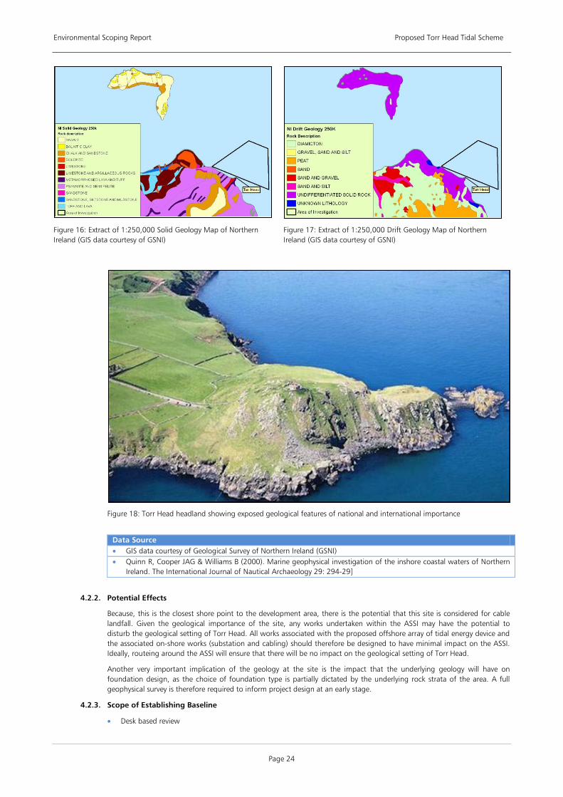
Environmental Scoping Report Proposed Torr Head Tidal Scheme
Page 24
Figure 16: Extract of 1:250,000 Solid Geology Map of Northern Ireland (GIS data courtesy of GSNI)
Figure 17: Extract of 1:250,000 Drift Geology Map of Northern Ireland (GIS data courtesy of GSNI)
Figure 18: Torr Head headland showing exposed geological features of national and international importance
Data Source • GIS data courtesy of Geological Survey of Northern Ireland (GSNI) • Quinn R, Cooper JAG & Williams B (2000). Marine geophysical investigation of the inshore coastal waters of Northern
Ireland. The International Journal of Nautical Archaeology 29: 294-29]
4.2.2. Potential Effects
Because, this is the closest shore point to the development area, there is the potential that this site is considered for cable landfall. Given the geological importance of the site, any works undertaken within the ASSI may have the potential to disturb the geological setting of Torr Head. All works associated with the proposed offshore array of tidal energy device and the associated on-shore works (substation and cabling) should therefore be designed to have minimal impact on the ASSI. Ideally, routeing around the ASSI will ensure that there will be no impact on the geological setting of Torr Head.
Another very important implication of the geology at the site is the impact that the underlying geology will have on foundation design, as the choice of foundation type is partially dictated by the underlying rock strata of the area. A full geophysical survey is therefore required to inform project design at an early stage.
4.2.3. Scope of Establishing Baseline
• Desk based review
Environmental Scoping Report Proposed Torr Head Tidal Scheme
Page 25
Undertake a review of existing geological data, both on shore and offshore.
• Survey Work A full geophysical survey will be required of the study area. Since there is significant information regarding the
Torr Head ASSI available, it is not envisaged that any further geological investigations will be required of that location.
A geotechnical investigation will be undertaken comprising sediment cores along the transect of the proposed cable landfall across the inter-tidal zone to establish the nature of the mobile sediments and beach core and to inform the design burial depth of the cables.
• Consultation with the DoENI and NIEA will required if cable landfall options falls within the boundary of the ASSI. The scope of the geophysical survey will be agreed with NIEA and key consultees prior to commencement of survey.
4.2.4. Impact Assessment
The EIA will examine the results of the geophysical survey in the context of possible foundation designs and inform recommendations as to the most appropriate technology suitable to the offshore geological conditions. The EIA will consider the importance and value of the ASSI.
The results of all site investigations undertaken as part of the proposed development including geophysical surveys of the seabed will be passed to the Geological Survey of Northern Ireland to contribute to the further understanding of the geological setting of Torr Head.
4.2.5. Cumulative Impacts
Please refer to Section 7 for an initial assessment of the potential cumulative impacts in regard to geology.
4.2.6. Relevant Guidance
Relevant Guidance Documents • The Blue Book: "The Complete ISRM Suggested Methods for Rock Characterization, Testing and Monitoring:1974-
2006'. International Society for Rock Mechanics (1978) “Rock Classification Testing and monitoring Suggested Methods.” ISRM Oxford
• BS5930 (1999) “Code of Practice for site investigations” BS London
Table 5: Relevant geology guidance documents
4.3.
4.3.1. Current Knowledge
WATER QUALITY AND SUSPENDED SEDIMENTS
Northern Ireland’s National Marine Monitoring Programme (NMMP) monitors coastal waters as part of the compliance with the EU Water Framework Directive. The monitoring comprises the measurement of priority substances, specific pollutants. physio-chemistry, hydromorphology, benthic invertebrates, angiosperms, marco-algae and phytoplankton
The most recent physio-chemical monitoring results for the area of the development were recorded on 12 February 2009 [3
Current water quality within the area of investigation, based on the above studies, is expected to be satisfactory. This is due to the rural nature of Torr Head, the general low levels of anthropogenic pressures associated with the area. The strong tidal flow regime off Torr Head also implies there is negligible risk of contamination of seabed sediments from sewage and land run-off as these are rapidly dispersed offshore.
]. The results indicate that the coastal water body in which the area of investigation lies is classified as ‘Good Status’. The draft River Basin Management Plan for the North Eastern River Basin District, December 2008 describes the coastal water body in which the area of investigation lies as having ‘Good Ecological Status’.
The seabed within the area of investigation is known to generally comprise coarse materials (boulders, cobbles and gravels) indicative of the presence of high energy tidal conditions as described in the Section 4.1 – Coastal Processes. This information would also indicate low levels of contamination since most contaminants adhere to fine silts and clays which are generally absent on tideswept, cobbled seabeds.
4.3.2. Potential Effects
There are a number of possible activities related to the installation, operation and decommissioning of a tidal turbine array which may have an impact on water quality and suspended sediments levels. These are listed below.
• Construction Potential increase in suspended sediments in the water column due to spoil/cuttings arising from foundations
that are drilled/piled and cable laying.
Indirect effects of increased suspended sediment on water quality, benthic and fish ecology.
Potential release of increased radioactivity/contaminant inherent in rock strata or seabed if drilling of foundations is required.
3. Site Code 31. Location 2.4 km NNE of Torr Head (latitude 55 13.008, longitude 06 04.558W)
Environmental Scoping Report Proposed Torr Head Tidal Scheme
Page 26
Release of grout into the water column if used as part of pile design.
Possible pollution in water column from vessels and turbine unit oils/lubricants.
• Operation Possible pollution in water column from vessels.
Possible pollution from leakage of turbine unit oils, anti-foulants and lubricants.
Increase or decrease in suspended sediments arising from changes in sediment transport due to impacts on the hydrodynamic regime (see Section 4.1 – Coastal Processes)
• Decommissioning Potential increase in suspended sediments in the water column due to foundation removal.
Possible pollution in water column from vessels and turbine unit oils/lubricants
The effects of increased sediment loading during the construction phase are potentially smothering of benthic communities and increased turbidity. Increased turbidity may result in reduced dissolved oxygen levels, which may also have an effect on benthic, fish and algal ecology. The extent of these effects will be determined largely by the choice of foundation method chosen and the associated construction methodology, particle size of spoil, the hydrodynamics at the site, and the sensitivity of benthos. For example a drilled monopile is likely to create a much larger volume of drillings and spoil than a seabed moored or gravity base structure. Lower currents speeds may mean greater settlement of particles and hence increased smothering of seabed communities. However research shows from offshore wind farms and modelling of tidal processes suggests that such impacts may only be near-field and minimal in effect.
4.3.3. Scope of Establishing Baseline
The following key work items are required to establish a robust baseline for further impact assessment.
• Desk top review Undertake a review of relevant national, regional and local policies concerned with the protection and
conservation of coastal waters.
Data screening exercise to asses existing datasets for baseline definition of water quality data for the site including bathing water quality and complete a gap analysis.
• Survey Work Sediment and water samples will be collected and analysed for particle size and contaminants as part of the site
investigation works which support the engineering design of the array of tidal devices.
Long-term (full tidal cycle i.e. 29 day) monitoring at agreed control and construction locations using multi-parameter sensor (turbidity, salinity, temperature).
• Consultation with the NIEA will be undertaken to assess the need for sediment dispersion modelling based on predicted spoil volume produced and hydrodynamics of the site and the sensitivity of benthic community. As discussed above the detailed scope of the coastal processes modelling will be discussed with NIEA in due course.
4.3.4. Impact Assessment
Based on the information gathered from the baseline studies, an impact assessment on the water quality of the site, including any sensitive far-field locations such as popular bathing beaches where water quality is measured, will be undertaken as a result of the proposed development. Depending on the proximity of sensitive benthic communities to the proposed works, computational modelling may be required to quantify the impact of sediment plumes which may arise during foundation installation works.
The objective of the EU Water Framework Directive is to prevent the deterioration of, and protect, enhance and restore all surface and groundwater bodies to achieve ‘Good Status’. The proposed development of the array of tidal energy devices should not prevent these objectives being met.
4.3.5. Mitigation
Mitigation measures that are applied will be dependent upon which technology and construction methods are finally adopted. The following measures are therefore possible suggestions for mitigation that could be adopted and/or good practice measures that can be incorporated into works method statements. They include:
• Use of non toxic anti-foulants such as Intersleek 737, as used at the MCT project at Strangford Lough • Spoil storage units on drilling vessel to allow spoil to be captured, settled out and fine particles released on peak tidal
flow to maximise dispersion. • Option to dispose of larger particles onshore to minimise impacts of smothering. • Implementation of an Environmental Management System designed to minimise the risks of spillages in construction
and operational phases of development; • Where possible maximise use of biodegradable oils in hydraulic machinery; and • Any waste generated during the operation and maintenance phase will be disposed of by licensed waste management
contractors and facilities onshore.
Environmental Scoping Report Proposed Torr Head Tidal Scheme
Page 27
4.3.6. Cumulative Impacts
Please refer to Section 7 for an initial assessment of the potential cumulative impacts in regard to water quality and suspended sediments
4.4.
This section addresses the potential impacts from noise and vibration generated as a result of the construction and operation of the proposed tidal energy array development in the vicinity of Torr Head. The section will deal with both the impacts associated with airborne noise generated onshore and those impacts associated with offshore underwater noise.
NOISE
4.4.1. Current Knowledge
Onshore, the site of the proposed tidal array and associated on-shore works is located in or close to a rural environment with few existing anthropogenic noise sources. There are no fixed noise receptors in close vicinity to the site itself such as residential properties or schools. The main noise receptors would be occasional visitors to the site.
There is no information available in regard to the background underwater noise levels at the site. Sensitive receptors would include marine life, the most sensitive of which are likely to be cetaceans (whales and dolphins).
4.4.2. Potential Effects
Onshore, the main sources of noise and vibration from the proposed development will occur during the construction phase and decommissioning phases
• Construction Noise disturbance associated with the construction of substation, temporary increase in traffic levels, cable
laying works in the intertidal area and general construction works. Due to their temporary nature, it is likely that noise levels associated with these activities will fall within British Standard (BS) thresholds.
• Operation Noise may be generated by electricity transformers and switchgear within the site boundary of an on-shore
substation.
Potentially, noise may be generated by transformer cooling systems.
• Decommissioning Noise disturbance associated with the decommissioning of the substation, increased traffic to site, cable and
general decommissioning works.
Offshore, the main sources of underwater noise and vibration are likely to be as follows:
• Construction Noise disturbance associated with the installation of turbine foundations, especially in the case of piling
activities, vessel movements and other marine engineering works. This may cause disturbance to marine life, in particular cetaceans.
• Operation Depending on the design of turbine, noise may be generated by moving parts, gearboxes etc. Depending on
frequency and volume this has the potential to cause disturbance to marine life.
Cavitation of turbines may occur, giving rise to some noise. However this would be associated with a reduction in efficiency and sub-optimal turbine performance and is unlikely to persist due to routine maintenance.
Vessel noise as a result of operational maintenance activities may cause disturbance.
• Decommissioning Noise disturbance associated with the decommissioning of foundations and associated marine works.
4.4.3. Scope of Establishing Baseline
The following key work items are required to establish a robust baseline for further impact assessment.
• Desk top review A review will be undertaken of the relevant national, regional and local policies concerned with the level of
noise and vibration permitted in rural areas.
Identification of key receptors both onshore and offshore.
A desk-based study will be undertaken to ascertain expected air borne and underwater noise levels from key activities.
Key receptors will be identified.
• Survey Work Baseline noise monitoring, if required, will be conducted in accordance with published guidance using a Type 1
sound level meter. Noise measurements may be required during both day-time and night-time hours as the tidal energy devices will be operational 24 hours.

Environmental Scoping Report Proposed Torr Head Tidal Scheme
Page 28
No similar standard exists for acquiring underwater baseline conditions but such baseline measurements will be undertaken in appropriate and representative conditions. An example methodology as defined by COWRIE , as was used in the MCT Strangford Lough project is referred to below as relevant guidance.
• Consultations with the relevant statutory authority, most notably, the relevant environmental health officer will be undertaken to ascertain whether background noise monitoring is warranted, and if so, to agree locations for carrying out such monitoring. The marine mammal studies outlined in Section 5.3 – Large Marine Species will also be relevant to this exercise.
4.4.4. Impact Assessment
Based on the information gathered from the baseline studies, an assessment of the significance of impacts on key receptors related to airborne noise and vibration during the construction, operational and decommissioning phases will be assessed. This assessment will be in line with the guidance detailed below.
The assessment of impacts on key receptors related to underwater offshore noise generated during the construction, operational and decommissioning phases will be modelled based on baseline measurements, predicted noise levels and the acoustic sensitivity of key marine species. Where possible the work undertaken at Strangford Lough in respect to noise levels will be taken into account, subject to obtaining the relevant permissions and licences.
4.4.5. Mitigation
Noise onshore will minimised through proper maintenance of plant and use of best practicable options such as effective exhaust silencers on mechanical equipment. Compressors will be ‘sound reduced’ models. Temporal restrictions of onshore construction works could also be applied.
Offshore, mitigation based on JNCC piling activities guidelines could be used to minimise disturbance to marine life during construction. This would employ the use of Marine Mammal Observers (MMOs) to ensure no animals are in close proximity prior to construction activities initiating. The deployment of Acoustic Deterrent Devices (ADDs) could also be used to deter animals from the general area during construction periods.
Underwater operational noise will be minimised by efficient operation and maintenance program.
4.4.6. Cumulative Impacts
Please refer to Section 7 for an initial assessment of the cumulative impacts in regard to noise.
4.4.7. Relevant Guidance
Relevant Guidance Documents • BS4142 (1997): “Method for rating industrial noise affecting mixed residential and industrial areas” • BS5228 (1997): “Noise and Vibration control on Construction and Open Sites” • Guidelines for Minimising Acoustic Disturbance to Marine Mammals from Seismic Survey, Annex. A Statutory nature
conservation agency protocol for mitigation of wind farm piling noise at sea, June 2009 • ISO 1996 “Acoustics – Measurement and Prediction of environmental noise” • Nedwell J R , Parvin S J, Edwards B, Workman R , Brooker A G and Kynoch J E Measurement and interpretation of
underwater noise during construction and operation of offshore windfarms in UK waters. Subacoustech Report No. 544R0738 to COWRIE Ltd. ISBN: 978-0-9554279-5-4.
• WHO (1999): “Guidelines for Community Noise”
Table 6: Relevant noise guidance documents

Environmental Scoping Report Proposed Torr Head Tidal Scheme
Page 29
5 BIOLOGICAL ENVIRONMENT
This section summarises the potential effects and impacts of the development on the biological aspects of the environment including conservation designations, ornithology, large marine species, benthic and inter-tidal ecology, terrestrial ecology and fish ecology. Key work items for establishing baseline information are identified, including both desk based reviews and additional survey work required. Important issues to be addressed in the impact assessment are outlined and recommendations are made regarding necessary consultations and guidance documents that may be of relevance.
5.1.
5.1.1. Current Knowledge
CONSERVATION DESIGNATIONS
There are a number of conservation designations in the area around the proposed project site. These include the European designations of Special Protection Area (SPA) and Special Area of Conservation (SAC), collectively known as Natura 2000 sites, and the national designation of Area of Special Scientific Interest (ASSI). Those in the area around the proposed site are shown in Figure 19.
Figure 19: Rathlin Island Special Protection Area
Data Source • JNCC website (2009). [WWW] <URL: http://www.jncc.gov.uk/page-0> [Accessed 11/08/09] • Northern Ireland Environment Agency website (2009). [WWW] <URL: http://www.ni-environment.gov.uk/index.htm>
[Accessed 11/08/09]
SACs are designated under the Council Directive 92/43/EEC on the Conservation of Natural Habitats and Wild Fauna and Flora (EC Habitats Directive). This Directive requires the establishment of a network of European protected sites which aim to conserve Annex I habitats and/or Annex II species. In Northern Ireland, this Directive is translated into law through the Conservation (Natural Habitats, etc.) Regulations (Northern Ireland) 1995 and the Conservation (Natural Habitats, etc.) (Amendment) Regulations (Northern Ireland) 2007.
SPAs are sites designated under the Council Directive 79/409/EEC on the Conservation of Wild Birds (EC Birds Directive). The Directive requires the establishment of a network of European protected sites which aim to protect a number of rare and vulnerable birds as listed in Annex I of the Directive. In Northern Ireland, this Directive is translated into law through the Wildlife (Northern Ireland) Order 1985, the Nature Conservation and Amenity Lands (Northern Ireland) Order 1985 and the Conservation (Natural Habitats, &C.) (Northern Ireland) Regulations 1995 (as amended).
The provisions of both Natura 2000 designations include the maintenance of the favourable conservation status of a site or species. If the development has the potential to have a significant adverse impact on the conservation features for which the SAC or SPA is designated, then the proposal may be subject to Appropriate Assessment. This process aims to determine whether or not the development would have a significant adverse impact on the conservation interest feature and on the overall ecological integrity of the site.
All onshore Natura 2000 sites in Northern Ireland are also designated as Areas of Special Scientific Interest (ASSI). These sites are designated under the Environment (Northern Ireland) Order 2002 and are managed by the Northern Ireland
Environmental Scoping Report Proposed Torr Head Tidal Scheme
Page 30
Environment Agency (NIEA). Should a development be thought likely to harm the conservation interest of a site then the regulator considering the application with take this designation into account during the decision making process.
There are three sites of particular concern for the proposed project; the Rathlin Island SAC, Rathlin Island SPA and Torr Head ASSI. These are discussed further below. There are a number of other sites designated in the region, however as the extent of onshore works has not yet been fully defined these designations have been summarised in Appendix 3, which provides a full list of Northern Irish coastal conservation designations within 40km of the area of investigation.
Rathlin Island SAC
The designation of the Rathlin Island SAC lists the following coastal formations as primary features:
• Reefs • Vegetated sea cliffs of the Atlantic and Baltic coasts • Submerged or partially submerged caves And the following as qualifying features:
• Sandbanks which are slightly covered by water all the time • Annual vegetation of drift lines Of particular concern for this site are the reefs and sandbanks which have the potential to be impacted by changes in coastal processes potentially arising from the proposed development. Should there be considered to be a risk of significant adverse impact to the maintenance of the conservation status of the site then Appropriate Assessment may be required.
Rathlin Island SPA
The designation of the Rathlin Island SPA lists the following qualifying species/features [4
• Peregrine Falco peregrinus, 6 pairs representing at least 1.6% of the breeding population in Ireland
]:
• Guillemot Uria aalge, 28,064 pairs representing at least 1.2% of the breeding East Atlantic population • Razorbill Alca torda, 5,978 pairs representing at least 1.0% of the breeding population • During the breeding season, the area regularly supports 66,000 individual seabirds including: Puffin Fratercula arctica,
Kittiwake Rissa tridactyla, Herring Gull Larus argentatus, Lesser Black-backed Gull Larus fuscus, Common Gull Larus canus, Fulmar Fulmarus glacialis, Razorbill Alca torda, Guillemot Uria aalge.
Terrestrial species such as peregrine are unlikely to be effected by the development however. Of particular potential concern are the diving birds if their foraging ranges are shown to include the project area of investigation. If the development has the potential to impact on the favourable conservation status of the species at the SPA, based on a critical percentage, then Appropriate Assessment may be required.
Torr Head ASSI
Torr Head ASSI runs along a stretch of the coastline adjacent to the project area of investigation. The designation of this site is for ‘the best exposure of metamorphosed Limestone of Dalradian age in Northern Ireland’ and is discussed further in Section 4.2 (Geology).
5.1.2. Potential Effects
Operational activities have the potential to impact on the Rathlin Island SAC and SPA sites. The potential effects include (but are not limited to) the following and are discussed in more detail in Section 4.1 (Coastal Processes) and Section 5.2 (Ornithology).
• Impacts to reefs and sandbank features caused by changes in coastal processes • Collision of diving birds with turbine blades
5.1.3. Consultation
The statutory consultee with regard to the Natura 2000 designations is the NIEA. Should Appropriate Assessment be required, this will be undertaken by competent authority, which in this case is DoENI for the FEPA application and DETI for the Article 39 application. The statutory consultee for any ASSI designations is the NIEA.
5.1.4. Cumulative Impacts
Please refer to Section 7 for an initial assessment of the potential cumulative impacts in regard to conservation designations.
5.1.5. Relevant Guidance
Relevant Guidance Documents • The Habitats Regulations: A guide for competent authorities (2002). Published by Northern Ireland Environment and
Heritage Service.
Table 7: Relevant conservation guidance documents
4. The island has also been listed as a UK marine ‘hotspot’ by WWF due to its exceptional species richness, and number of nationally rare species.
Environmental Scoping Report Proposed Torr Head Tidal Scheme
Page 31
5.2.
5.2.1. Current Knowledge
ORNITHOLOGY
The Antrim Coastline, including Torr Head and its environs, hosts a number of marine and coastal bird species.
As noted in Section 5.1 (Conservation Designations), Torr Head is approximately 8km from Rathlin Island which in addition, to its coastal features has been designated for the bird species it supports. These include a number of the Annex I species, namely Peregrine Falcon (Falco peregrinus), and up to 5 pairs of Chough (Pyrrhocorax pyrrhocorax) have been bred on the site and the site contributes to the maintenance of the Chough range in the UK. The site qualifies under the EU Directive by supporting internationally important breeding numbers of the following seabird species: Razorbill (Alca torda), Guillemot (Uria aalge) and Kittiwake (Rissa tridactyla). The SPA also regularly supports over 20,000 breeding seabirds including puffin (Fratercula arctica), fulmar (Fulmarus glacialis), shag (Phalacrocorax aristotelis) and gannet (Morus bassanus).
Whilst there is no ornithological data from dedicated surveys available for the area of study off Torr Head, it is likely that some informal sightings information will be available and most of the species mentioned above will utilise the area of investigation for some periods of the year. Where these birds originate from the SPA there will concern over the impact of the development on the SPA site and its bird features. Due to the proximity of the Rathlin Island SPA and the mobile nature of seabirds, it is possible that Appropriate Assessment may be required as described in Section 5.1 – Conservation Designations.
5.2.2. Potential Effects
Many of the species listed, puffin, razorbill, guillemot, gannet and shag are diving species and forage for their food underwater and as such are more at risk from collision with the moving underwater turbines. Species which are surface feeders, such as kittiwakes and gulls may be more at risk from disturbance from vessels, as are those species which rest or moult on the sea surface. Key effects are listed below.
• Construction There is potential of disturbance to birds due to elevated human activity, 24 hour lighting and general increased
levels of construction activity from offshore vessels and onshore works.
Inter-tidal and wading birds may be affected by cable landfall works.
There is a potential pollution risk to marine birds from spillages, particularly oils from vessels.
There is potential risk of reduced prey from the loss of sub-tidal and inter-tidal habitat from cable works.
• Operation There is a collision risk to diving birds from the movement of the turbine parts through the water. The choice of
turbine design will have a significant impact on collision risk. A moored system which does not have a position in the water column is likely to present a greater risk than those designs which have a fixed position.
Indirect impacts on foraging behaviour and food sources through loss of habitat.
There is a potential pollution risk to marine birds from spillages, particularly oils from vessels.
• Decommissioning There is potential for disturbance to birds due to elevated human activity during decommissioning, similar to
those during construction.
There is a potential pollution risk to marine birds from spillages, particularly oils from vessels.
5.2.3. Scope of Establishing Baseline
The following key work items are required to establish a robust baseline for further impact assessment.
• Desk top review A review will be undertaken of the relevant national, regional and local policies concerned with the protection
of marine birds and their habitats.
A desk-based study will be undertaken to gather all available information on birds found in the vicinity of the array, cable route and cable landfall. Specifically those species sensitive to collision risk will be highlighted. Data will be requested from British Trust for Ornithology (BTO), JNCC, Royal Society for the protection of Birds (RSPB) and the NIEA.
Identification of data gaps to inform the scope of fieldwork.
• Survey Work Due to the apparent lack of site specific data and the proximity of the site to the Rathlin island SPA it is likely
that a programme of survey works will be required. It is likely that site specific bird counts and observations on bird movements and behaviours will be required over at least one breeding and one over-wintering bird season to ascertain bird utilisation of the site. Surveys are likely to be boat- based.
• Consultation will take place with NIEA and other relevant organisations, such as the RSPB to seek advice on the extent and mode of surveys required e.g. the necessity for boat based surveys. Advice will be sought on the necessity for an Appropriate Assessment in light of the proximity of the Rathlin Island SPA to the site.
Environmental Scoping Report Proposed Torr Head Tidal Scheme
Page 32
5.2.4. Impact Assessment
Based on the information gathered from the baseline studies, an assessment of the impact on marine birds will be made. The assessment shall be undertaken by a suitably qualified ornithological consultant specialising in marine birds and in line with appropriate guidance. The assessment will take into account, due to the proximity of the Rathlin Island SPA, the impacts of the development on SPA species. Collision risk analysis may also be relevant depending upon the turbine device chosen, and this will be undertaken if necessary.
5.2.5. Mitigation
Mitigation measures that are applied are dependent upon methods that are finally adopted. Collision risk can be reduced through turbine design and this will be assessed early in the planning process. Risk of pollution incidents can be minimised by good practice measures such as adherence to an Environmental Management System designed to minimise the risks of spillages. Depending on the results of the baseline surveys, consideration may need to be given to restricting piling activity to times outside the main bird breeding season.
5.2.6. Cumulative Impacts
Please refer to Section 7 for an initial assessment of the potential cumulative impacts in regard to ornithology.
5.2.7. Relevant Guidance
Where applicable, guidance developed by Scottish Natural Heritage (SNH) will be referred to in respect of ornithology, as recommended on NIEA website.
Relevant Guidance Documents • Camphuysen, C. J., Fox, A. D., Leopold, M. F. & Pertersen, I. K. (2004) Towards a standardised seabird at sea census
techniques in connection with environmental impact assessments for offshore wind farms in the UK: a comparison of ship and aerial sampling methods for marine birds, and their applicability to offshore wind farm assessments. NIOZ report to COWRIE.
• King, S., Maclean, I., Norman, T. and Prior, A. (2009). Developing Guidance on Ornithological Cumulative Impact Assessment for Offshore Wind Farm Developers. COWRIE
• M. Ruddock and D.Whitfield (2007). A Review of Disturbance Distances in Selected Bird Species. A report from Natural Research (Projects) Ltd to Scottish Natural Heritage
• SNH Guidance Note Survey Methods for Use in Assessing the Impacts of Onshore Windfarms on Bird Communities November 2005
• SNH Guidance Note: Windfarms and Birds: Calculating a theoretical collision risk assuming no avoiding action (2000)
Table 8: Relevant ornithology guidance documents
5.3. Large Marine Species
This section will encompass issues related to cetaceans, seals and turtles that may utilise the area. Basking Sharks will be addressed in Section 5.6 (Fish and Shellfish Ecology).
5.3.1. Current Knowledge
There is limited data available for this area.
All cetacean species (whales, dolphins and porpoises) occurring in European waters are afforded protection under the EU Habitats Directive. They are all included in Annex IV of the Directive as European Protected Species (EPS) “in need of strict protection”. The Harbour Porpoise (Phocoena phocoena) and Bottlenose Dolphin (Tursiops truncatus) are afforded additional protection and are included in Annex II of the Directive as species of ‘community interest’, whose conservation requires the designation of SACs.
The Irish Whale and Dolphin Group (IWDG) manage a sightings database of all cetacean sightings in Ireland, totalling 13,000 records. This cetacean sightings data indicates that Harbour Porpoise, Bottlenose Dolphin, Common Dolphin (Delphinus delphis) and Minke Whale (Balaeanoptera acutorostrata) are present in the waters around Rathlin Island and Torr Head. The Seawatch Foundation identifies Rathlin Island as a good location from which to observe cetaceans. A small number of dedicated land based surveys have been initiated by IWDG in the region, the closest of which to the proposed site are at Fair Head, Murlough Bay and Rathlin Island.
An acoustic survey (Dunlop and Mellor, 2007) was undertaken at a number of test sites off the north Antrim and Rathlin Island coasts in waters up to 200m water channels, approximately 10 km from the area of investigation. A number of likely Sperm Whale (Physeter macrocephalus) vocalisations were recorded, indicating that this species may be present in the area. However, it should be noted that sperm whales are a deep diving species and are therefore unlikely to be present close to shore in shallower waters.
Ireland’s two seal species, the Common Seal (Phoca vitulina) and Grey Seal (Halichoerus grypus) are also designated Annex II species under the EU Habitats Directive. A survey in 2002 (Duck, 2006) counted Common and Grey Seals along the Northern Irish coast. 162 Common Seals and 5 Grey Seals (Duck , 2006) were counted in the region of Rathlin Island, which lists seals as Grade D feature of the Rathlin Island SAC and is the largest haul out site in the area (NIEA, pers. comm., 18/3/2009).
Environmental Scoping Report Proposed Torr Head Tidal Scheme
Page 33
A survey of marine turtles in Northern Irish waters was carried out between April and August 2006 (King, 2006). 24 sightings were made in Northern Irish waters, making the total number of records in the Northern Ireland marine turtle database 36. The majority of sightings were Leatherback Turtle (Dermochelys Coriacea) with fewer being recorded as Loggerhead Turtle (Mare Pacificum). There are limited records for Antrim waters.
Data Source • Duck C (2006). Results of the thermal image survey of seals around the coast of Northern Ireland. Environment and
Heritage Service Research and Development Series. No. 06/09 • Dunlop, R.A. and Mellor, A. (2008) Probable acoustic recordings of sperm whales (Physeter macrocephalus) along the
North Antrim coast, Northern Ireland. Biology and Environment: Proceedings of the Royal Irish Academy108B, 135_41. • http://www.iwdg.ie/. Irish Whale and Dolphin Group website. Accessed 10/09/2009 • http://www.seawatchfoundation.org.uk/index.php • King G (2006). Review of marine turtle records in Northern Ireland. Environment and Heritage. Service, Research and
Development Series. No 07/02.
5.3.2. Potential Effects
The key potential impacts on marine mammals from the construction and operation of the proposed tidal array development are displacement, disturbance and collision risk. Most marine mammals use sound as a means of communication, orientation and detecting prey. The presence of a noise source over and above normal background noise levels has the potential to cause direct injury or to interfere with their ability to communicate, orientate or catch prey and as such maybe be impacted by noise (see Section 4.4). Turtles are also thought to be sensitive to sound emissions.
It should be noted that under the Conservation (Natural Habitats, etc.) (Amendment) Regulations (Northern Ireland) 2007, the disturbance of any EPS (including all cetaceans) is a criminal offence.
• Construction Depending on the foundation type used, there will be potential noise disturbance from foundation installation.
Driven piles using a hammer system will produce the highest source levels and are of most concern.
Vessel movements and operation of construction vessels will potentially cause disturbance and may lead to displacement.
• Operation There will some noise associated with the operation of turbines but this is expected to be of a lower level than
during construction, albeit at different frequencies.
The moving parts of the turbines may present a collision risk for marine mammals and turtles. The choice of turbine design will have a significant impact on collision risk. A moored system which does not have a fixed position in the water column is likely to present a greater risk than those designs which have a fixed position. Similarly an ‘open’ turbine could have less impact than those designs with a large swept area as animals would be able to pass through it.
• Decommissioning Depending on the foundation type used, there will be potential noise disturbance from foundation removal.
Vessel movements and operation of decommissioning vessels will potentially cause noise disturbance.
5.3.3. Scope of Establishing Baseline
The following key work items are required to establish a robust baseline for further impact assessment.
• Desk top review Collate all existing data on marine mammal, seal and turtle usage of the area including details on species,
sightings, known routes, haul out sites, pupping areas, feeding grounds and population size. This will also include details on species-specific acoustic sensitivities.
Undertake a review of current research in regard to collision risk. A study is currently being undertaken in Wales, the results of which should be available to inform the EIA (J. Gordon, pers. comm.)
An analysis of current strandings data will be undertaken.
The results of any marine mammal monitoring which have been reported as part of MCT’s Strangford Lough project will be collated and reviewed.
• Survey Work Due to limited data being available for this area in regard to marine mammals and turtles it is recommended that a comprehensive baseline survey be undertaken. This will include:
Monthly visual surveys over a period of 12 months are envisaged for marine mammals and turtles to elucidate habitat use and seasonal trends in the area. Consultation (as detailed below) will confirm survey scope details.
It is likely that the visual surveys will need to be supplemented by the deployment of a number of Passive Acoustic Monitoring systems (C-PODs) through the proposed site area to supply acoustic data. The monitoring
Environmental Scoping Report Proposed Torr Head Tidal Scheme
Page 34
devices will be retrieved to download data every 3 months. The monthly sighting surveys will be used to verify the results of the passive acoustic monitoring.
An assessment of the local seal haul outs sites will be made.
• Consultation on these issues is important as marine mammals, seals and turtles have high conservation interest. Responses have been received from the IWDG and the Causeway Coast and Glens Heritage Trust regarding the scope of works to be undertaken and consultation with these interest groups will continue. Consultation will also be undertaken with the NIEA and CNCC to agree to the survey scope for baseline surveys to ensure the approach, data coverage and quality of the proposed surveys are satisfactory.
5.3.4. Impact Assessment
It will be necessary to assess the risk of displacement, disturbance and collision of marine mammals arising from the proposed scheme. This assessment shall be undertaken by a suitably qualified marine mammal specialist. Specifically, the following key aspects to be undertaken in the EIA are:
1. Based on known acoustic sensitivities of marine mammals, observed habitat use, sub-sea baseline noise measurements and predicted construction and operational source levels, the assessment will address the impacts of the potential construction and operational phases of the proposed development in respect to noise. The propagation of noise generated from the construction works, in particular, will be modelled to ascertain distances from the works where the presence of a marine mammal would trigger the temporary cessation of piling, drilling and installation activities (see Section 4.4).
2. Operational collision risk will be assessed for species that are found to be frequently in the area, using risk assessment techniques developed by the Scottish Association of Marine Sciences.
5.3.5. Mitigation
A number of mitigation measures could be adopted. Mitigation based on JNCC piling activities guidelines could be used to minimise harm to marine life. This would employ the use of Marine Mammal Observers (MMOs) to ensure no animals are in close proximity prior to construction activities initiating. Site specific guidelines would be generated to define an appropriate exclusion zone, delay times and soft starts procedures if applicable. The deployment of Acoustic Deterrent Devices (ADDs) could also be used to deter animals from the general area during construction periods, although this would need to be subject of careful considerations.
Collision risk can be reduced through turbine design and this will be assessed early in the planning process.
5.3.6. Cumulative Impacts
Please refer to Section 7 for an initial assessment of the potential cumulative impacts in regard to marine mammals.
5.3.7. Relevant Guidance
Relevant Guidance Documents • Diederichs, A., Nehls, G., Dähne, M., Adler, S., Koschinski, S. & Verfuß, U. 2008. Methodologies for measuring and
assessing potential changes in marine mammal behaviour, abundance or distribution arising from the construction, operation and decommissioning of offshore wind farms. COWRIE ENG-01-2007
• Guidelines for Minimising Acoustic Disturbance to Marine Mammals from Seismic Surveys. Annex A Statutory nature conservation agency protocol for mitigation of wind farm piling noise at sea – March 2008
• The Conservation (Natural Habitats, etc.) (Amendment) Regulations (Northern Ireland) 2007. DoE (NI) • The Conservation (Natural Habitats, etc.) Regulations (Northern Ireland) 1995
Table 9: Relevant large marine species guidance documents
5.4.
5.4.1. Current Knowledge
BENTHIC AND INTER-TIDAL ECOLOGY
Existing information on the benthic ecology for the south west of the area of investigation can be inferred from surveys of the seabed along the north east Antrim coast undertaken from 2000 to 2003. The surveys used a monitoring technique known as ‘RoxAnn’ which is a method of surveying the seabed using sonar technology. The output provides details of the sediment composition of the seabed from which an interpretation of the nature of the sub-tidal habitats can be made. There is, however, a need for extensive ground truthing associated with this survey method. The extent of the area covered by the RoxAnn survey within the area of investigation is presented in Figure 20.
The RoxAnn survey identified 8 habitat types within the area of investigation as shown in Figure 20. A brief description of these habitats and the indicative species likely to be present are described in the Table 10 below and illustrate that the benthic habitats present are representative of high energy tidal sites.
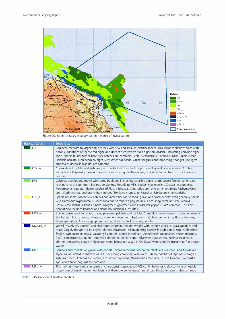
Environmental Scoping Report Proposed Torr Head Tidal Scheme
Page 35
Figure 20: Extent of RoxAnn survey within the area of investigation
Habitat Code Description EBf Boulders (medium to large) and bedrock with few and small interstitial spaces. This includes shallow areas with
notable quantities of foliose red algae and deeper areas where such algae are absent. Encrusting coralline algae, short, sparse faunal turf or bare rock patches are common. Echinus esculentus, Porania pulvillis, Luidia ciliaris, Henricia oculata, Ophiocomina nigra, Crossaster papposus, Cancer pagurus and branching sponges (Stelligera stuposa or Raspailia hispida) are common.
ECS.co Consolidated cobbles and pebbles (hard-packed) with a small proportion of gravel or coarse sand. Cobble surfaces are frequently bare, or covered by encrusting coralline algae, or a short faunal turf. Flustra foliacea is common.
ERu Cobbles, pebbles and gravel with some boulders. Encrusting coralline algae, short, sparse faunal turf or bare rock patches are common. Echinus esculentus, Porania pulvillis, Leptasterias muelleri, Crossaster papposus, Pomatoceros triqueter, dense patches of Flustra foliacea, Dendrodoa spp. and other ascidians, Pachymatisma spp., Clathrina spp. and branching sponges (Stelligera stuposa or Raspailia hispida) are characteristic.
ERU_K Sparse boulders, cobblefield patches and interstitial coarse sand, gravel and small pebbles with generally sparse kelp (Laminaria hyperborea, L. saccharina and Sacchoriza polyschides). Encrusting corallines, keel worms, Echinus esculentus, Asterias rubens, Glycymeris glycymeris and Crossaster papposus are common. This kelp habitat also includes bedrock and dense boulderfield substrates.
MCS.co Stable coarse sand and shell, gravel, pea-sized pebbles and cobbles. Some dead maerl gravel is found in areas of this habitat. Encrusting corallines are common, along with keel worms, Ophiocomina nigra, Flustra foliacea, Ebalia granulosa, Anomia ephippium and a tall faunal turf on many cobbles.
MCS.co_M Gravel (mainly dead maerl) and shell (both comminuted and whole) with cobbles and pea-gravel/pebbles and maerl (largely thought to be Phymatolithon calcareum). Characterising species include Lanice spp., Ophiothrix fragilis, Ophiocomina nigra, Caryophyllia smithii, Cliona intestinalis, Aequipecten opercularis, Pecten maximus (juv.), Pomatoceros triqueter, Anomia ephippium, Ophiura spp., Glycymeris glycymeris, Echinus esculentus, chitons, encrusting coralline algae and some foliose red algae in shallower waters and hydrozoan turf in deeper waters.
MRu Boulders and cobbles on gravel with pebbles. Small Laminaria saccharina plants are common, and foliose red algae are abundant in shallow waters. Encrusting corallines, keel worms, dense patches of Ophiothrix fragilis, Asterias rubens, Echinus esculentus, Crossaster papposus, Nemertesia antennina, Flustra foliacea, Polymastia spp. and Cancer pagurus are common.
MRu_M This habitat is very similar in terms of characterising species to MCS.co_M, however it also contains a notable proportion of small-medium boulders and therefore an increased faunal turf. Flustra foliacea is also common.
Table 10: Description of benthic habitats
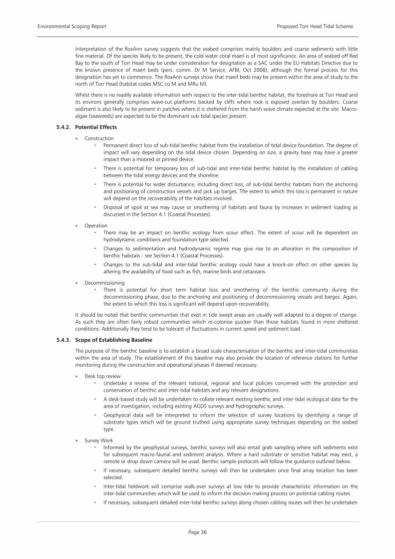
Environmental Scoping Report Proposed Torr Head Tidal Scheme
Page 36
Interpretation of the RoxAnn survey suggests that the seabed comprises mainly boulders and coarse sediments with little fine material. Of the species likely to be present, the cold water coral maerl is of most significance. An area of seabed off Red Bay to the south of Torr Head may be under consideration for designation as a SAC under the EU Habitats Directive due to the known presence of maerl beds (pers. comm. Dr M Service, AFBI, Oct 2008), although the formal process for this designation has yet to commence. The RoxAnn surveys show that maerl beds may be present within the area of study to the north of Torr Head (habitat codes MSC.co M and MRu M).
Whilst there is no readily available information with respect to the inter-tidal benthic habitat, the foreshore at Torr Head and its environs generally comprises wave-cut platforms backed by cliffs where rock is exposed overlain by boulders. Coarse sediment is also likely to be present in patches where it is sheltered from the harsh wave climate expected at the site. Macro-algae (seaweeds) are expected to be the dominant sub-tidal species present.
5.4.2. Potential Effects
• Construction Permanent direct loss of sub-tidal benthic habitat from the installation of tidal device foundation. The degree of
impact will vary depending on the tidal device chosen. Depending on size, a gravity base may have a greater impact than a moored or pinned device.
There is potential for temporary loss of sub-tidal and inter-tidal benthic habitat by the installation of cabling between the tidal energy devices and the shoreline.
There is potential for wider disturbance, including direct loss, of sub-tidal benthic habitats from the anchoring and positioning of construction vessels and jack up barges. The extent to which this loss is permanent in nature will depend on the recoverability of the habitats involved.
Disposal of spoil at sea may cause or smothering of habitats and fauna by increases in sediment loading as discussed in the Section 4.1 (Coastal Processes).
• Operation There may be an impact on benthic ecology from scour effect. The extent of scour will be dependent on
hydrodynamic conditions and foundation type selected.
Changes to sedimentation and hydrodynamic regime may give rise to an alteration in the composition of benthic habitats - see Section 4.1 (Coastal Processes).
Changes to the sub-tidal and inter-tidal benthic ecology could have a knock-on effect on other species by altering the availability of food such as fish, marine birds and cetaceans.
• Decommissioning There is potential for short term habitat loss and smothering of the benthic community during the
decommissioning phase, due to the anchoring and positioning of decommissioning vessels and barges. Again, the extent to which this loss is significant will depend upon recoverability.
It should be noted that benthic communities that exist in tide swept areas are usually well adapted to a degree of change. As such they are often fairly robust communities which re-colonise quicker than those habitats found in more sheltered conditions. Additionally they tend to be tolerant of fluctuations in current speed and sediment load.
5.4.3. Scope of Establishing Baseline
The purpose of the benthic baseline is to establish a broad scale characterisation of the benthic and inter-tidal communities within the area of study. The establishment of this baseline may also provide the location of reference stations for further monitoring during the construction and operational phases if deemed necessary.
• Desk top review Undertake a review of the relevant national, regional and local policies concerned with the protection and
conservation of benthic and inter-tidal habitats and any relevant designations.
A desk-based study will be undertaken to collate relevant existing benthic and inter-tidal ecological data for the area of investigation, including existing AGDS surveys and hydrographic surveys.
Geophysical data will be interpreted to inform the selection of survey locations by identifying a range of substrate types which will be ground truthed using appropriate survey techniques depending on the seabed type.
• Survey Work Informed by the geophysical surveys, benthic surveys will also entail grab sampling where soft sediments exist
for subsequent macro-faunal and sediment analysis. Where a hard substrate or sensitive habitat may exist, a remote or drop down camera will be used. Benthic sample protocols will follow the guidance outlined below.
If necessary, subsequent detailed benthic surveys will then be undertaken once final array location has been selected.
Inter-tidal fieldwork will comprise walk-over surveys at low tide to provide characteristic information on the inter-tidal communities which will be used to inform the decision making process on potential cabling routes.
If necessary, subsequent detailed inter-tidal benthic surveys along chosen cabling routes will then be undertaken
Environmental Scoping Report Proposed Torr Head Tidal Scheme
Page 37
• Consultations with the relevant statutory authority (NIEA) will be undertaken to agree the extent and methodology to be used in the benthic ecological surveys. Ongoing consultation would address, if applicable, the extent of monitoring required during the construction and operational phases. This would be dependent on the sensitivity of the benthic communities present. A programme of post-construction benthic monitoring could be undertaken to evaluate the level of potential impact of the operation of the tidal energy devices on the benthic ecology.
5.4.4. Impact Assessment
Through the characterisation and biotope mapping of the benthic communities, the baseline surveys will inform the decision making process on the precise locations of the arrays of tidal energy devices and cabling routes. This will assist in the avoidance of particularly sensitive habitats and minimise the potential environmental impact. Based on the selection of finer scale array location sites and cable route, an impact assessment on the sub-tidal and inter-tidal benthic ecology of the site will be undertaken. The assessment will be undertaken by an experienced team of marine and intertidal ecologists and will take into account the finding of the geophysical surveys and coastal processes modelling exercise.
5.4.5. Mitigation
The most effective mitigation in regard to mitigation of impacts on the benthic communities is at the design stage. The selection of the tidal turbine device, its location and installation method will all be carefully considered to mitigate potential impact.
5.4.6. Cumulative Impacts
Please refer to Section 7 for an initial assessment of the potential cumulative impacts in regard to benthic and inter-tidal ecology.
5.4.7. Relevant Guidance
Relevant Guidance Documents • Connor, D., Allen J., Golding, N., Howell, K., Lieberkneckt, L., Northern, K. and Reker, J. (2004)
The Marine Habitat Classification for Britain and Ireland Version 04.05 JNCC, Peterborough • Connor, D.W., Brazier, D.P., Hill, T.O., & Northen, K.O. 1997. Marine Nature Conservation Review: marine biotope
classification for Britain and Ireland. Vol. 1. Littoral biotopes. Version 97.06. Joint Nature Conservation Committee Report, No. 229.
• Connor, D.W., Dalkin, M.J., Hill, T.O., Holt, R.H.F., & Sanderson, W.G. 1997. Marine Nature Conservation Review: marine biotope classification for Britain and Ireland. Vol. 2. Sublittoral biotopes. Version 97.06. Joint Nature Conservation Committee Report, No. 230.
• J Davies, J Baxter, M Bradley, D Connor, J Khan, E Murray, W Sanderson, C Turnball and M Vincent (2001) Marine Monitoring handbook, JNCC.
• Seeley, B., Parr, J., Evans, J. & Lear, D. Establishing best practice for the documentation and dissemination of marine biological data.
Table 11: Relevant benthic and inter-tidal ecology guidance documents
5.5.
5.5.1. Current Knowledge
TERRESTRIAL ECOLOGY
The terrestrial habitats of Torr Head and its environs are typical of the North Antrim coast which represents an extensive area of exposed hard cliff. The basalt and chalk maritime cliff and slopes represent a diverse range of communities including those associated with rock crevices and cliff ledges, and with a range of typical maritime grasslands and heath. Notable species on the basalt cliffs include Wilson’s Filmy-fern (Hymenophyllum wilsonii), Thyme Broomrape (Orobanche alba), Hare’s Foot Clover (Trifolium arvense), Zigzag Clover (Trifolium medium) and Common Juniper (Juniperus communis). The chalk cliffs support neutral and species rich calcareous grasslands. Plants present in the grassland include Pignut (Conopodium majus), Harebell (Campanula species), Kidney Vetch (Anthyllis vulneraria) and several orchid species.
Mammal species which may be present include Otter (lutra lutra), Badger (meles meles), various bat species and Irish hare (Lepus timidus). There are likely to be terrestrial birds present which may use the site for breeding and feeding purposes.
5.5.2. Potential Effects
• Construction The construction of an on-shore substation of 100MW capacity will require a footprint of approximately 25m x
50m. The substation’s footprint together with any further hard-standings required for site access will result in a permanent loss of terrestrial habitat.
The potential loss of habitat may have a knock-on loss for foraging and breeding mammals and birds.
Potential habitat loss and physical disturbance from onshore cable route installation.
• Operation There are unlikely to be any effects to terrestrial ecology during the operational phase other than occasional
maintenance visits.

Environmental Scoping Report Proposed Torr Head Tidal Scheme
Page 38
• Decommissioning It is anticipated that any land disturbed during construction of the project will be replanted and re-established
as part of the decommissioning phase.
5.5.3. Scope of Establishing Baseline
The following key work items are required to establish a robust baseline for further impact assessment.
• Desk top review Undertake a review of the relevant national, regional and local policies concerned with the protection of
terrestrial environments.
A desk-based study will be undertaken to gather all available information on terrestrial habitats and the corresponding flora and fauna found at the Torr Head site.
• Survey Work The assessment will include a Phase I Habitat survey which will be carried out in accordance with Joint Nature
Conservation Committee (JNCC) guidelines. Based on the outcome of the extended Phase I Habitat survey a Phase 2 habitat survey may be requested involving specialist expertise, for example a Badger survey.
• Consultation will be undertaken with NIEA to ensure the scope and methodologies of the proposed surveys are appropriate.
5.5.4. Impact Assessment
Based on the information gathered from the baseline studies, an assessment of the potential impacts on terrestrial ecology will be made. This assessment shall be undertaken by an experienced and qualified terrestrial ecologist. Terrestrial vegetation distribution will be mapped and key sensitivities identified. The results of the environmental impact assessment will feed into the site selection process to determine the optimum location of the on-shore substation and for the routing of cabling with a view to causing minimal impact on the terrestrial ecology.
5.5.5. Mitigation
The level of mitigation required will be influenced by the sensitivity of habitats and the species present. Possible mitigation options include planning the construction work programme of the on-shore elements to minimise disturbance to breeding mammals or birds. Native plant species, typical of the area, will be used in any planting associated with landscaping around the perimeter of the on-shore substation.
5.5.6. Cumulative Impacts
Please refer to Section 7 for an initial assessment of the potential cumulative impacts in regard to terrestrial ecology.
5.5.7. Relevant Guidance
Relevant Guidance Documents • CIRIA C587 - ‘Working with Wildlife’ • Institute of Ecology and Environmental Management (2006) Guidelines for Ecological Impact Assessment in the United
Kingdom (version 7 July 2006). • JNCC (2007) Handbook for Phase 1 habitat survey − a technique for environmental audit
Table 12: Relevant terrestrial ecology guidance documents
5.6.
5.6.1. Current Knowledge
FISH AND SHELLFISH ECOLOGY
Information on the location of spawning and nursery grounds for a range of fish species is available from the Centre for Environment, Fisheries & Aquaculture Science (Cefas) This information shows that the area of investigation may contain suitable spawning habitat for whiting, sprat and nephrops and suitable spawning and nursery habitat for whiting and nephrops.
Potential Importance as Spawning Grounds Potential Importance as Nursery Grounds • Whiting • Whiting • Sprat • Nephrops • Nephrops
Table 13: Potential spawning and nursery grounds within area of investigation
Other fish species of interest are elasmobranches, which are a group of fish which include sharks, skates and rays, which may be sensitive to electromagnetic frequencies created by cables.
Basking Sharks are the largest of the elasmobranches and of any fish found in UK waters and the second largest in the world. Sightings of basking shark have been made along the Antrim coastline each year between 2004 – 2008 as recorded by Irish Whale and Dolphin Group (and see EHS, 2006).
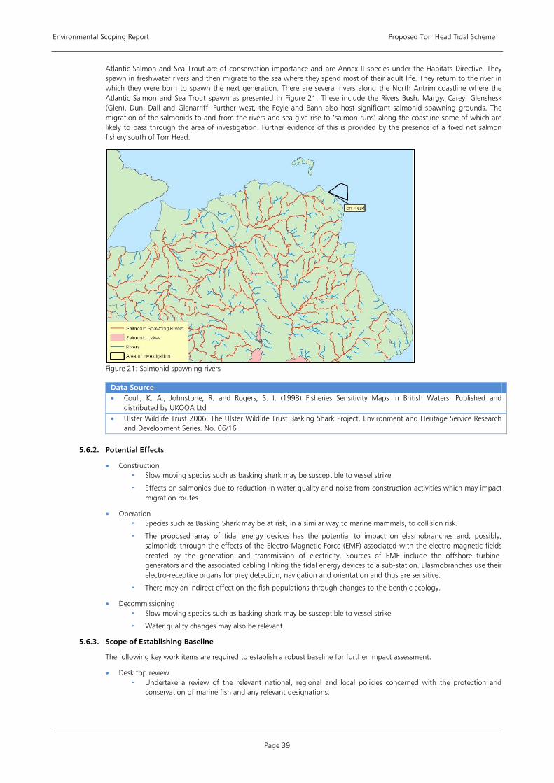
Environmental Scoping Report Proposed Torr Head Tidal Scheme
Page 39
Atlantic Salmon and Sea Trout are of conservation importance and are Annex II species under the Habitats Directive. They spawn in freshwater rivers and then migrate to the sea where they spend most of their adult life. They return to the river in which they were born to spawn the next generation. There are several rivers along the North Antrim coastline where the Atlantic Salmon and Sea Trout spawn as presented in Figure 21. These include the Rivers Bush, Margy, Carey, Glenshesk (Glen), Dun, Dall and Glenarriff. Further west, the Foyle and Bann also host significant salmonid spawning grounds. The migration of the salmonids to and from the rivers and sea give rise to ‘salmon runs’ along the coastline some of which are likely to pass through the area of investigation. Further evidence of this is provided by the presence of a fixed net salmon fishery south of Torr Head.
Figure 21: Salmonid spawning rivers
Data Source • Coull, K. A., Johnstone, R. and Rogers, S. I. (1998) Fisheries Sensitivity Maps in British Waters. Published and
distributed by UKOOA Ltd • Ulster Wildlife Trust 2006. The Ulster Wildlife Trust Basking Shark Project. Environment and Heritage Service Research
and Development Series. No. 06/16
5.6.2. Potential Effects
• Construction Slow moving species such as basking shark may be susceptible to vessel strike.
Effects on salmonids due to reduction in water quality and noise from construction activities which may impact migration routes.
• Operation Species such as Basking Shark may be at risk, in a similar way to marine mammals, to collision risk.
The proposed array of tidal energy devices has the potential to impact on elasmobranches and, possibly, salmonids through the effects of the Electro Magnetic Force (EMF) associated with the electro-magnetic fields created by the generation and transmission of electricity. Sources of EMF include the offshore turbine-generators and the associated cabling linking the tidal energy devices to a sub-station. Elasmobranches use their electro-receptive organs for prey detection, navigation and orientation and thus are sensitive.
There may an indirect effect on the fish populations through changes to the benthic ecology.
• Decommissioning Slow moving species such as basking shark may be susceptible to vessel strike.
Water quality changes may also be relevant.
5.6.3. Scope of Establishing Baseline
The following key work items are required to establish a robust baseline for further impact assessment.
• Desk top review Undertake a review of the relevant national, regional and local policies concerned with the protection and
conservation of marine fish and any relevant designations.
Environmental Scoping Report Proposed Torr Head Tidal Scheme
Page 40
An assessment of key salmon spawning rivers and their migration routes including a review of migration times and catch data.
Collate existing data on Basking Shark usage of the area including details on species, sightings and known routes.
Source and collate relevant existing fisheries data for the site.
• Survey Work It is anticipated that fish survey work would not usefully add to the understanding of this site in terms of fish ecology, however further consultation with NIEA and DARD would be required on this issue to determine the requirement for bean-trawl surveys and a specific elasmobranches monitoring programme.
• Consultations Consultation with NIEA will be undertaken in regard to fish species of conservation importance.
5.6.4. Impact Assessment
The assessment shall be undertaken by a suitably qualified fish ecologist to determine the significance of the site for fish species and level of impact likely to arise from the proposed scheme. Based on the information gathered from the baseline studies, an impact assessment on fish ecology will be undertaken as a result of the proposed development. The assessment will include a detailed literature review of the potential impact of EMF, with reference to up to date guidance on elasmobranches and identify the most practical steps which can be taken to minimise this potential risk.
5.6.5. Mitigation
A number of mitigation measures could be adopted. Construction works that may increase the turbidity of the water could be planned to avoid the peak migration times of the salmonids passing through the area of interest. Or alternatively, an effective spoil management system which reduces spoil releases into the water column could be adopted. Temporal restrictions may be applied to construction works to minimise the impact on potential fishery spawning, nursery grounds and migration routes.
Any guidelines adopted in respect of marine mammals, to minimise collision risk, will also be applicable to Basking Sharks.
5.6.6. Cumulative Impacts
Please refer to Section 7 for an initial assessment of the potential cumulative impacts in regard to fish and shellfish ecology.
5.6.7. Relevant Guidance
Relevant Guidance Documents • Gill, A.B., Huang, Y., Gloyne-Philips, I., Metcalfe, J., Quayle, V., Spencer, J. & Wearmouth, V. (2009). COWRIE 2.0
Electromagnetic Fields (EMF) Phase 2: EMF-sensitive fish response to EM emissions from sub-sea electricity cables of the type used by the offshore renewable energy industry. Commissioned by COWRIE Ltd (project reference COWRIE-EMF-1-06).
Table 14: Relevant fish and shellfish ecology guidance documents
Environmental Scoping Report Proposed Torr Head Tidal Scheme
Page 41
6 HUMAN ENVIRONMENT
This section summarises the potential effects and impacts of the development on the human aspects of the environment including shipping and navigation; commercial fisheries; landscape and seascape; archaeology and cultural heritage; socio-economic including tourism and recreational activities; and, climate change. Key work items for establishing baseline information are identified, including both desk based reviews and additional survey work required. Important issues to be addressed in the impact assessment are outlined and recommendations are made regarding necessary consultations and guidance documents that may be of relevance.
6.1.
6.1.1. Current Knowledge
SHIPPING AND NAVIGATION
There is approximately 35 km (19 NM) in distance between Torr Head (Northern Ireland) and Mull of Kintyre (south west Scotland). This narrow strait of water is called the North Channel and connects the Northern Irish Sea to the Atlantic Ocean. It is used extensively by recreational, commercial and fishing vessels. There is an International Maritime Organisation (IMO) Traffic Separation Scheme (TSS) within the Northern Channel that segregates traffic into two lanes; the entry/exits areas of these schemes are considered high risk for navigation. This route is frequently used by laden tankers transiting from oil fields in the north of Scotland to refineries in Wales and southern England.
There is potential for significant implications for navigation as a result of the installation of a tidal energy array in the area both during construction and, depending on the nature of the turbine selected, after construction. As discussed in Section 3.4, the exact type of tidal energy device is not known yet. Though it is likely that the turbines will be completely submerged, there may be some elements, including possibly an offshore substation that will be visible above water.
Data Source • Online GIS System to display maritime data for the entire UK. It includes input from:
Maritime and Coastguard Agency Department for Transport Department for Environment Food and Rural Affairs The Crown Estate Royal Yachting Association Ministry of Defence British Marine Aggregate Producers Association Anatec UK Ltd
• UKHO Electronic Chart UKHO Chart 1121 Irish Sea
6.1.2. Potential Effects
Potential consequences for navigation include an increase in risk associated with the installation of a tidal energy array in the area and its proximity to the TSS. These consequences and associated risks will vary during different phases of the projects and depending on the features of the turbine selected. Though it is likely that the turbines will be submerged at all tidal conditions, there may be some elements of the supporting structure and the offshore substation that will be visible above water. These surface structures and underwater clearance depths could create an increase in risk for vessels navigating in the area and will need to be analysed in detail prior to device and location selection.
• Construction An increase in vessel activity in and around the area including vessels restricted in their ability to manoeuvre
(RAM) will result in a higher traffic density and increased collision risk, particularly during construction.
Increased risk on the laden tankers transiting the area.
Potential for small craft to be displaced into the TSS the presence of additional vessels during construction.
Increased collision risk during darkness or reduced visibility.
• Operation Implications on vessels in an emergency situations resulting from the chance of drifting into the array.
Increased risk on the laden tankers transiting the area.
Potential for small craft to be displaced into the TSS by the siting of the array.
• Decommissioning An increase in vessel activity during decommissioning, including vessels restricted in their ability to manoeuvre
(RAM) will result in a higher traffic density and increased collision risk.
Increased risk on the laden tankers transiting the area.
Potential for small craft to be displaced into the TSS by the presence of additional vessels during decommissioning activities.
6.1.3. Scope of Establishing Baseline
• Desk top Review Based on the requirements outlined in the MGN 371, the following are required to establish a baseline.
Environmental Scoping Report Proposed Torr Head Tidal Scheme
Page 42
The acquisition of four weeks of AIS data split into two seasonal sections (preferably winter/summer). This data will then be calculated to show the 90th percentile and a 1nm buffer to identify key shipping routes (as per the MCA Shipping template contained in MGN 371).
Small scale navigational charts to identify any key navigational features in and around the proposed site.
RYA Atlas to identify key leisure and racing routes in the area.
Fishing Traffic density data (basic data available from DECC Maritime Data Website.
Tidal information to ascertain potential areas of increased risk due to strong tidal currents.
Metocean data particularly the frequency of reduced visibility conditions in the area.
• Survey Work As per MGN 371; an up to date vessel traffic radar surveys of the area concerned will be undertaken within 12 months prior to submission of the ES to identify numbers, types and sizes of vessels presently using such areas. However, if deemed necessary, to cover seasonal variations or perceived future traffic trends, the survey period may be extended to a maximum of 24 months, in which period a minimum of 42 days survey is required, and pro rata, i.e. 35 days during an 18 month period. This will include acquisition of both AIS and Radar data to ensure coverage of all vessels types in the area.
Identification of non-transit uses of the areas, e.g. fishing, day cruising of leisure craft, commercial passenger vessels undertaking visits to the OREI, racing, aggregate dredging, etc.
Identification of whether the area contains transit routes used by coastal or deep-draught vessels on passage.
• Consultation As part of the initial scoping phase, the Marine and Coastguard Agency (MCA) and the Commissioners of Irish Lights were both consulted. In addition to these organisations, the following key consultees have been identified in respect to shipping and navigation issues:
Royal Yachting Association Northern Ireland (RYANI);
Conference of Yacht Cruising Clubs (CYCC);
Local fishermen through the National Federation of Fishermans Organisations (NFFO);
The Crown Estate (to identify other marine uses in the area);
Ministry of Defence (MoD); and,
Stakeholders identified by the navigational review including but not limited to: main vessel operator routes that regularly cross within or near the site, local sailing clubs and marinas, local fishing groups, port operators and local emergency response providers (e.g. RNLI).
It is proposed that the following keys areas, as defined in MGN 371 are addressed with consultees and stakeholders. These include the proximity of the array to:
Prescribed routeing schemes or precautionary areas.
Prescribed or conventionally accepted separation zone between two opposing routes.
Anchorages, safe haven, port approaches and pilot boarding or landing areas.
The limits of jurisdiction of a port and/or navigation authority.
Existing fishing grounds, or to routes used by fishing vessels to such grounds.
Offshore firing/bombing ranges or ordnance dumping grounds and areas used for any marine military purposes either presently or in the past.
Existing or proposed offshore oil / gas platform, marine aggregate dredging, marine archaeological sites or wrecks, or other exploration/exploitation sites. This will include projects in the planning process, in addition to those consented.
Other existing or proposed OREI developments, in co-operation with other relevant developers, within each round of lease awards.
Designated areas for the disposal of dredging spoil.
Any types of aids to navigation and/or Vessel Traffic Services (VTS) in or adjacent to the area and any impact thereon.
6.1.4. Impact Assessment
The EIA will be developed using guidance laid out in the DECC document ‘Assessment of the Impact of Offshore Wind Farms: Methodology for Assessing the Marine Navigational Safety Risks of Offshore Wind Farms’ and the MCA MGN 371 ‘Offshore Renewable Energy Installations (OREIs) – Guidance on UK Navigational Practice, Safety and Emergency Response Issues’.
The key features of the EIA methodology that the developer shall address are outlined below, these include and take in to account all initial scoping responses received from the Marine and Coastguard Agency (MCA) and Commissioners of Irish Lights.
Environmental Scoping Report Proposed Torr Head Tidal Scheme
Page 43
• The EIA, including the navigational review will be carried out by a competent provider who has expertise of the traffic patterns in the affected area, including fishing and recreation activity as well as commercial shipping and military activity.
• Consultation with key stakeholders including the General Lighthouse Authority (GLA) and specifically with the Commissioners of Irish Lights including advice on the requirement and position of the navigation aids.
• Describe adequate marking of the boundary of the southbound lane of the TSS which borders the scheme. • Examine substantial adverse impact on the inshore traffic zone and the impact on smaller commercial and recreational
vessels in terms of its significance from a mariner’s perspective: for example, deviation from normal routes, increased passage times and increased interaction between vessels
• Assess the feasibility of different vessels types navigating within or close to the site. • Examine the navigational difficulties likely to be incurred during the construction phase. • Undertake a hazard review where all the hazards associated with the proposed tidal project can be identified and ranked
for the different phases (as there will be different levels of activity in terms of service vessels, mobile cranes, tugs and barges operating in the area). They can then be ranked in terms of frequency and consequences. Any existing or proposed mitigation measures in place at the proposed site can also be recorded. This exercise should define which hazards will require to be considered in more detail either qualitatively or in a quantitative evaluation.
• Undertake an accident frequency assessment for the different phases with the results of the assessment benchmarked against risk results generated in UK wide studies to give an indication of the level of risk relative to other areas around the UK.
• Conduct a review of risk mitigation measures in which conclusions and recommendations can be made to help minimise potential risk and obstruction to shipping during operation of the tidal project as well as during construction, maintenance and decommissioning phases. The mitigation measures considered will be based on the risk results generated to ensure that the risks associated with the site are As Low As Reasonably Practicable (ALARP).
• Consider search and rescue aspects. • Consider alignment and proximity of the site relative to adjacent shipping routes including application of the MCA
shipping template. • Assess researched opinion using appropriate computer simulation techniques with respect to the displacement of traffic
and, in particular, the creation of ‘choke points’ in areas of high traffic density.
6.1.5. Mitigation
Depending on the final design of tidal device, array configuration and outcome of the detailed navigational risk assessment, it is likely that a range of mitigation and safety measures will be applied to the tidal array. The specific measures to be employed will be selected in consultation with the Maritime and Coastguard Agency and will be listed in the Environmental Statement. These will be consistent with international standards and could include any or all of the following:
• Promulgation of information and warnings through notices to mariners and other appropriate media. • Continuous watch by multi-channel VHF, including Digital Selective Calling (DSC). • Application of safety zones of appropriate configuration, extent and application to specified vessels. • Designation of the site as an area to be avoided (ATBA). • Implementation of routeing measures within or near to the development. • Monitoring by radar, AIS and/or closed circuit television. • Appropriate means to notify and provide evidence of the infringement of safety zones or ATBAs. • Suitable navigation aids as agreed with the Commissioners of Irish Lights to enable the safe passage of fishing vessels
around the array of tidal energy devices. • Notices to Mariners issued to publicise the location of the new navigation aids and marked on updates to the Admiralty
Charts. • Any other measures and procedures considered appropriate in consultation with other stakeholders but could include
routeing measures or Vessel Traffic Services (VTS) schemes.
6.1.6. Cumulative Impacts
Please refer to Section 7 for an initial assessment of the potential cumulative impacts in regard to shipping and navigation.
6.1.7. Relevant Guidance
Relevant Guidance Documents • Guidance on the Assessment of the Impact of Offshore Wind Farms: Methodology for Assessing the Marine
Navigational Safety Risks of Offshore Wind Farms • MGN 371 - Offshore Renewable Energy Installations (OREIs) - Guidance on UK Navigational Practice, Safety and
Emergency Response Issues. • MGN 372 – Guidance to Mariners Operating in the vicinity of OREI’s.
Table 15: Relevant shipping and navigation guidance documents
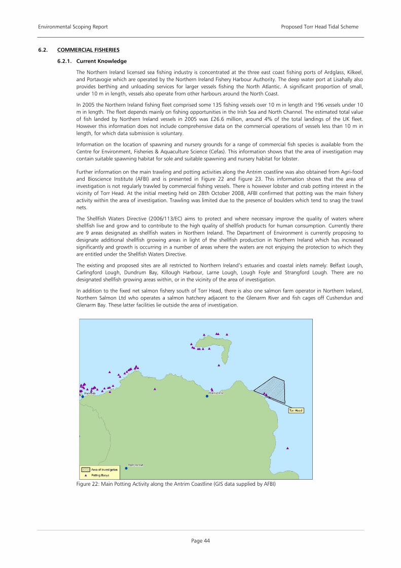
Environmental Scoping Report Proposed Torr Head Tidal Scheme
Page 44
6.2.
6.2.1. Current Knowledge
COMMERCIAL FISHERIES
The Northern Ireland licensed sea fishing industry is concentrated at the three east coast fishing ports of Ardglass, Kilkeel, and Portavogie which are operated by the Northern Ireland Fishery Harbour Authority. The deep water port at Lisahally also provides berthing and unloading services for larger vessels fishing the North Atlantic. A significant proportion of small, under 10 m in length, vessels also operate from other harbours around the North Coast.
In 2005 the Northern Ireland fishing fleet comprised some 135 fishing vessels over 10 m in length and 196 vessels under 10 m in length. The fleet depends mainly on fishing opportunities in the Irish Sea and North Channel. The estimated total value of fish landed by Northern Ireland vessels in 2005 was £26.6 million, around 4% of the total landings of the UK fleet. However this information does not include comprehensive data on the commercial operations of vessels less than 10 m in length, for which data submission is voluntary.
Information on the location of spawning and nursery grounds for a range of commercial fish species is available from the Centre for Environment, Fisheries & Aquaculture Science (Cefas). This information shows that the area of investigation may contain suitable spawning habitat for sole and suitable spawning and nursery habitat for lobster.
Further information on the main trawling and potting activities along the Antrim coastline was also obtained from Agri-food and Bioscience Institute (AFBI) and is presented in Figure 22 and Figure 23. This information shows that the area of investigation is not regularly trawled by commercial fishing vessels. There is however lobster and crab potting interest in the vicinity of Torr Head. At the initial meeting held on 28th October 2008, AFBI confirmed that potting was the main fishery activity within the area of investigation. Trawling was limited due to the presence of boulders which tend to snag the trawl nets.
The Shellfish Waters Directive (2006/113/EC) aims to protect and where necessary improve the quality of waters where shellfish live and grow and to contribute to the high quality of shellfish products for human consumption. Currently there are 9 areas designated as shellfish waters in Northern Ireland. The Department of Environment is currently proposing to designate additional shellfish growing areas in light of the shellfish production in Northern Ireland which has increased significantly and growth is occurring in a number of areas where the waters are not enjoying the protection to which they are entitled under the Shellfish Waters Directive.
The existing and proposed sites are all restricted to Northern Ireland’s estuaries and coastal inlets namely: Belfast Lough, Carlingford Lough, Dundrum Bay, Killough Harbour, Larne Lough, Lough Foyle and Strangford Lough. There are no designated shellfish growing areas within, or in the vicinity of the area of investigation.
In addition to the fixed net salmon fishery south of Torr Head, there is also one salmon farm operator in Northern Ireland, Northern Salmon Ltd who operates a salmon hatchery adjacent to the Glenarm River and fish cages off Cushendun and Glenarm Bay. These latter facilities lie outside the area of investigation.
Figure 22: Main Potting Activity along the Antrim Coastline (GIS data supplied by AFBI)

Environmental Scoping Report Proposed Torr Head Tidal Scheme
Page 45
Figure 23: Main Trawling Activity along the Antrim Coastline (GIS data supplied by AFBI)
Data Source • GIS data supplied by Agri-Food Biosciences Institute
6.2.2. Potential Effects
• Construction Temporary disruption is likely to be caused to fishing activity in the area and temporary exclusion zones due to
the physical presence and movement of the marine plant and vessels, including the laying of cables.
Potential for increasing the suspended solids loading within the water column during the dredging process which may have an impact on the benthic ecology, including fishery spawning and nursery areas.
Possible displacement of target species leading to a reduction in catch.
• Operation The presence of the array of tidal energy devices may present a physical obstruction and a navigational risk and
therefore may curtail certain fishing activities, particularly trawling and scallop dredging.
The presence of the array of tidal energy devices may give raise to navigational issues for fishing vessels traversing the area.
The presence of cables, if not buried, may cause snagging of some types of fishing gear.
Indirect effect of target species displacement, leading to catch reduction.
• Decommissioning Temporary disruption is likely to be caused to fishing activity in the area by obstruction from decommissioning
vessels.
6.2.3. Scope of Establishing Baseline
The following key work items are required to establish a robust baseline for further impact assessment.
• Desk top review Undertake a review of the relevant national, regional and local policies concerned with commercial fisheries.
Gather and collate relevant existing commercial fisheries data for the site.
• Survey Work Appoint of a locally based Fisheries Liaison Officer (FLO) to undertake a local fishery activity survey. This will
include preliminary discussions with local fisheries committees and individual fisherman who fish the area to ascertain the level of use and types of gear deployed.
It is anticipated that fish survey work would not usefully add to the understanding of this site in terms of fish target species, however further consultation with NIEA and DARD would required on this issue.
• Consultations with the relevant statutory authorities (Department of Agriculture and Rural Development (DARD) and AFBI) will be undertaken along with local fisheries groups as described above. The appointment of an FLO is a key

Environmental Scoping Report Proposed Torr Head Tidal Scheme
Page 46
position to facilitate local consultation with the fishing community, who will be key stakeholders in regard to the development of the proposed project. All consultation will be carried out in line with recommendations made by the BERR Fishing Liaison with Offshore Wind and Wet Renewables Group (FLOWW).
6.2.4. Impact Assessment
Based on the information gathered from the baseline studies, the EIA will assess the level of impact on local commercial fisheries through the consultation and dialogue with DARD, AFBI and local commercial fishing operators.
6.2.5. Mitigation
Depending on the final design of the tidal device and array configuration a number of possible mitigation options are available. In addition to those measures outlined in Section 6.1 (Shipping and Navigation), an agreement with local fishermen could be agreed to temporarily relocate pots where there is a potential conflict with the programme of works required to construct the array of tidal energy devices and cable protection to minimise snagging of fishing gear. Such agreements would be facilitated by the appointment of a local FLO.
6.2.6. Cumulative Impacts
Please refer to Section 7 for an initial assessment of the potential cumulative impacts in regard to commercial fisheries.
6.2.7. Relevant Guidance
Relevant Guidance Documents • BERR (2008) Fishing Liaison with Offshore Wind and Wet Renewables Group (FLOWW) - Recommendations for
Fisheries Liaison: Best Practice Guidance for Offshore Renewables Developers. URN 08/935.
Table 16: Relevant commercial fisheries guidance documents
6.3.
6.3.1. Current Knowledge
LANDSCAPE AND SEASCAPE
Those areas considered of high scenic value in Northern Ireland are designated ‘Areas of Outstanding Natural Beauty’ (AONB) under the Nature Conservation and Amenity (NI) Order 1985 by the DoENI. The proposed development at Torr Head lies within and adjacent to the Antrim Coast and Glens AONB as presented in Figure 24.
Figure 24: Antrim Coast and Glens AONB (outlined in purple on map)
The Antrim Coast and Glens AONB contains a varied landscape including Northern Ireland’s only inhabited offshore island, bays and valleys, dramatic headlands and open expanses of moorland. A management plan is in place for the Antrim Coast and Glens AONB. The management of the AONB is spread amongst a number of bodies including the Causeway Coast and Glens Heritage Trust, Local Authorities, community organisations and representatives from the tourism, farming and environmental sectors.
The DoENI has categorised Northern Ireland’s landscape into 130 Landscape Character Areas. The onshore elements of the proposed development at Torr Head fall within the Fair Head Landscape Character Area as presented in Figure 25. The offshore elements will be close proximity to this coastline. The key characteristics of the Fair Head Landscape Character Area are described as follows:
• Narrow coastal strip on the northern slopes of the Antrim Plateau; • Dramatic cliffs with igneous intrusions giving rise to prominent heathlands and sheltered bays;
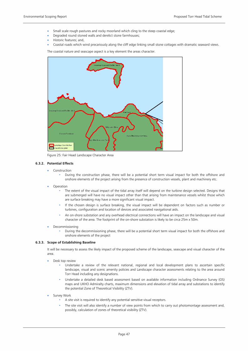
Environmental Scoping Report Proposed Torr Head Tidal Scheme
Page 47
• Small scale rough pastures and rocky moorland which cling to the steep coastal edge; • Degraded round stoned walls and derelict stone farmhouses; • Historic features; and, • Coastal roads which wind precariously along the cliff edge linking small stone cottages with dramatic seaward views.
The coastal nature and seascape aspect is a key element the areas character.
Figure 25: Fair Head Landscape Character Area
6.3.2. Potential Effects
• Construction During the construction phase, there will be a potential short term visual impact for both the offshore and
onshore elements of the project arising from the presence of construction vessels, plant and machinery etc.
• Operation The extent of the visual impact of the tidal array itself will depend on the turbine design selected. Designs that
are submerged will have no visual impact other than that arising from maintenance vessels whilst those which are surface breaking may have a more significant visual impact.
If the chosen design is surface breaking, the visual impact will be dependent on factors such as number or turbines, configuration and location of devices and associated navigational aids.
An on-shore substation and any overhead electrical connections will have an impact on the landscape and visual character of the area. The footprint of the on-shore substation is likely to be circa 25m x 50m.
• Decommissioning During the decommissioning phase, there will be a potential short term visual impact for both the offshore and
onshore elements of the project
6.3.3. Scope of Establishing Baseline
It will be necessary to assess the likely impact of the proposed scheme of the landscape, seascape and visual character of the area.
• Desk top review Undertake a review of the relevant national, regional and local development plans to ascertain specific
landscape, visual and scenic amenity policies and Landscape character assessments relating to the area around Torr Head including any designations.
Undertake a detailed desk based assessment based on available information including Ordnance Survey (OS) maps and UKHO Admiralty charts, maximum dimensions and elevation of tidal array and substations to identify the potential Zone of Theoretical Visibility (ZTV).
• Survey Work A site visit is required to identify any potential sensitive visual receptors.
The site visit will also identify a number of view points from which to carry out photomontage assessment and, possibly, calculation of zones of theoretical visibility (ZTV).
Environmental Scoping Report Proposed Torr Head Tidal Scheme
Page 48
• Consultations will be undertake with the Planning Service, DETA and NIEA to identify and agree possible viewpoints suitable for photomontage work and to identify any sensitivities associated with the site in respect of visual amenity.
6.3.4. Impact Assessment
The landscape and visual impact assessment will be based on the maximum dimensions of proposed infrastructure, i.e. the worst case scenario. The assessment will be undertaken by an experienced, qualified landscape architect and in accordance with the relevant guidance. It will address the following:
1) A landscape character impact assessment to assess the landscape character and its sensitivity to the proposed development. The assessment will consider the scale of the change, the degree of impact and the duration of impact.
2) Visual impact assessment, which will map the ZTV and together with photomontages will be used to support the assessment of the level of significance of the visual impact of the proposed development.
3) The impacts in seascape will be assessed in line with relevant guidance
6.3.5. Mitigation
The possible mitigation measures that can be employed to minimise the impacts of the on-shore offshore elements of the development include the selection of sensitive colour for structures and landscaping and planting to screen onshore structures from sensitive view points. Mitigation options offshore are limited to selection of the device design and the location of the array.
6.3.6. Cumulative Impacts
Please refer to Section 7 for an initial assessment of the potential cumulative impacts in regard to landscape, seascape and visual issues.
6.3.7. Relevant Guidance
Relevant Guidance Documents • DTI (2005) Guidance on the Assessment of the Impact of Offshore Wind Farms: Seascape and Visual • Hill, M., Briggs, J., Minto, P., Bagnall, D., Foley, K. and Williams, A. (2001) Guide to Best Practice in Seascape
Assessment. Maritime Ireland/Wales INTERREG Report No. 5 Impact Report. • Landscape Institute with the Institute of Environmental Management and Assessment (2002) Guidelines for Landscape
and visual impact assessment, Second Edition. ISBN 0-415-23185-X
Table 17: Relevant landscape and seascape guidance documents
6.4.
6.4.1. Current Knowledge
ARCHAEOLOGY AND CULTURAL HERITAGE
The terrestrial and maritime archaeology and cultural heritage of the region can be defined into three broad categories: important archaeological landscapes; remains and sites that are evidence of Britain’s early history; and more recent remains and sites that reflect Britain’s pivotal role as a major naval, mercantile and industrial nation. Archaeological sites and features span all of these broad categories. The following are examples of remains and sites found within the area:
• The Antrim Coast and Glens, which has been settled since Mesolithic times (7000 - 4000BC) is archaeologically significant. Neolithic (4000 – 2500BC) axe heads from Rathlin Island were traded throughout Britain and Ireland.
• Portal and Passage Tombs such as at Carnanmore close to Torr Head are common. • Bronze Age sites including Dunteige Wedge Tomb and Knockdhu promontory fort which overlooks Ballygally. • A large promontory fort at Lurigethan is likely to date from the Iron Age (300BC – AD400). • Raths and Cashels such as Atlagore Cashel near Cushendun are typical of the Early Christian period whilst medieval
monuments include Bonamargy Friary and Bruce’s Castle on Rathlin Island. • Ballygally Castle is the most famous building from the plantation period and has been in continuous use for over 400
years. • There are ruined buildings below Torr Head that were once custom houses and a lookout station. • In the 1800s, Torr Head was a semaphore signalling station that recorded the passage of trans-atlantic ships and relayed
the information to Lloyds of London and the port of destination. • The old radio masts and outbuildings that once were a transmission and listening station for the Royal Air Force can still
be seen on the Hill at Torr Head.
The locations of the known archaeological sites in the vicinity of Torr Head from the Sites and Monuments Record are shown in Figure 26.

Environmental Scoping Report Proposed Torr Head Tidal Scheme
Page 49
Figure 26: Archaeological Sites in Vicinity of Torr Head
Torr Head is the closest point in Northern Ireland to Scotland, situated only 12 miles from the Mull of Kintyre, and has a very strong maritime heritage:
• The Scottish clansmen who settled along the north coast of Antrim from time to time used Torr Head as a beacon from which they summoned assistance from their allies in Argyllshire.
• The old radio masts and outbuildings that once were a transmission and listening station for the Royal Air Force can still be seen on the Hill at Torr Head.
• There are old ruined buildings below Torr Head. There were once custom houses and an old lookout station. • In the 1800’s, Torr Head (similar to Malin Head in Co. Donegal) was a semaphore signalling station that recorded the
passage of trans-atlantic ships and relayed the information to Lloyds of London and the port of destination.
Further evidence of the maritime cultural heritage of Torr Head is provided by a number of known shipwrecks in the vicinity of the Torr Head, whose locations are shown in Figure 27. There are three shipwrecks within the study area, with another four situated on the boundary just off Torr Head. Some wrecks are protected under the Protection of Wrecks Act (1973), although none of the above wrecks are designated as Protected Wrecks.
The strong associations between the North Antrim Coastline and Scotland have played a particularly important role in defining the cultural heritage of the area. Previously part of the ancient sea kingdom of Dalriada, the Scottish influence is evident everywhere in place-names, music, language and dance. Fought over by the McQuillans, McDonnells and near neighbours the O’Neills its turbulent history is reflected in the many battle sites throughout the area such as Slieveanorra, Glentaisie and Rathlin. There is a rich tradition of folklore along the North Antrim coast and the area has always had strong beliefs in fairies etc. Many of the place names reflect this tradition such as Feystown (town of the fairies), Breen (the fairy palace) and Skeagh (the fairy thorn).
In terms of legend and mythology, there are many famous characters and stories associated with the North Antrim coastline and sea. Fionn MacCumhaill, one of the most famous Irish mythical heroes is associated with the Giant’s Causeway. It is said that he built it as a stepping stone over to Scotland to avoid his feet getting wet. “The Childen of Lir”, a famous Irish legend involves the main characters in the story spending time on the “Sea of Moyle” which is an old name for the North Channel. The area has many literary associations and oral history, music and traditional dance are still strong. Parts of North Antrim are famous for traditional Irish sports such as hurling whilst four oar gig racing takes place within many of the coastal villages.
Data Source • Williams B & McErlean T (2002). Maritime archaeology in Northern Ireland. Antiquity, June 2002.]

Environmental Scoping Report Proposed Torr Head Tidal Scheme
Page 50
Figure 27: Known Shipwrecks in Vicinity of Torr Head
6.4.2. Potential Effects
• Construction Disturbance of known and previously unrecorded submarine archaeological sites during construction activities
including foundation installation, vessel anchoring or jack up barge, and cabling activities.
Disturbance of known and previously unrecorded archaeological sites in the intertidal zone or on land during construction activities such as the laying of cables and site preparation works for the on-shore substation.
• Operation Disturbance of maritime archaeological features or sites, in particular wrecks, due to destabilization of seabed
through changes to the sedimentary regime.
• Decommissioning Disturbance of known and previously unrecorded submarine archaeological sites during decommissioning
activities
6.4.3. Scope of Establishing Baseline
The following key work items are required to establish a robust baseline for further impact assessment.
• Desk top review Undertake a review of the relevant national, regional and local policies concerned with the protection and
conservation of the terrestrial and marine archaeology including any relevant designations.
Source and collate relevant existing archaeological data for the site through examination of documentary, cartographic and aerial photographic sources. This will include the collation of any known history of site usage through searches of publicly accessible archives such as the Centre for Maritime Archaeology, University of Ulster and NIEA. This information will be used to inform the scope of field work.
A detailed desk based assessment of the marine geophysical survey will be undertaken. Data should include results of side-scan and magnetometer surveys to identify evidence of any items of potential archaeological significance on or below the seabed.
• Survey Work A walkover survey of the terrestrial and foreshore areas which may be impacted by the proposed development is
required to identify any possible features of previously unrecorded archaeological interest.
Any features of interest revealed during the assessment of geophysical data may need ground truthing.
• Consultations with the relevant statutory authority (NIEA) will be undertaken.

Environmental Scoping Report Proposed Torr Head Tidal Scheme
Page 51
6.4.4. Impact Assessment
The assessment on archaeological features will be undertaken by an experienced archaeologist with specialist knowledge in maritime archaeology and carried out in accordance with the relevant guidance.
6.4.5. Mitigation
Due to the nature of many covered or buried archaeological sites it is possible that archaeological material or sites which were previously unrecorded may be disturbed during the onshore construction works. To address this, a ‘watching brief’ and monitoring of excavated materials during construction will be undertaken. Topsoil stripping along the line of the cabling and at the site of the on-shore substation to search for archaeological material in advance of the construction works may be required subject to the requirements of NIEA.
6.4.6. Cumulative Impacts
Please refer to Section 7 for an initial assessment of the potential cumulative impacts in regard to archaeology and cultural heritage.
6.4.7. Relevant Guidance
Relevant Guidance Documents • COWRIE (2008), Guidance for Assessment of Cumulative Impacts on the Historic Environment from Offshore
Renewable Energy. Commissioned by COWRIE Ltd (project reference CIARCH-11-2006). • Historic Environment Guidance for the Offshore Renewable Energy Sector, COWRIE 2007 - (Wessex Archaeology • Institute for Archaeologists (IfA) Standard and Guidance for Archaeological Desk-based Assessment (IfA 2008). • Marine Aggregate Dredging and the Historic Environment: Guidance Note. Code of Practice for Seabed Developers,
Joint Nautical Archaeology Policy Committee 2006 (JNAPC)
Table 18: Relevant archaeology and cultural heritage guidance documents
6.5.
6.5.1. Current Knowledge
SOCIO-ECONOMIC INCLUDING TOURISM AND RECREATION
The Moyle district, encompassing the Torr Head area covers an area of 479km2 and its population is estimated at 16,515. Moyle is a largely rural district reflected by the lower population density (0.34 persons/ha) compared to the rest of Northern Ireland (1.22 persons/ha). There are approximately 5,500 jobs in the Moyle district making up less that 1% of the Northern Irish total. The employment structure is dominated by Wholesale & Retail (17%); Health (16%); Education (16%); and Hotels (15%). These sectors account for close to two-thirds of employment in Moyle.
Tourism plays a central role in the economic life of the north Antrim coastline. From the Giant’s Causeway World Heritage Site in the north west to the nine glens of Antrim on the eastern side, the Moyle District Council area hosts a variety of diverse attractions, including beaches at Portbradden and Whitepark, dramatic scenery and coastlines near Knocklayd Mountain, Rathlin Island, Fair Head, Torr Head and Murlough Bay, sites of historic interest at Dunseverick, Kinbane Castle and Bonamargy Friary and numerous small towns and villages (Bushmills, Cushendun, Cushendall and the market town of Ballycastle). The Giants Causeway is the most popular tourist attraction in Northern Ireland with over 700,000 visitors to its Visitor Centre in 2007, an increase in 30% on 2006 figures. Carrick-a-Rede Rope Bridge located near Ballintoy Harbour had over 22,000 visitors in 2007.
Popular recreational activities in the Moyle District Area include the following:
• Outdoor activities and sports - golf, pony trekking, tennis, sailing, swimming. A number of waymarked tracks exist, one of which passes close by Torr Head (see Figure 28).
• Bird-watching - The north coast of Northern Ireland is popular with bird watchers. The RSPB seabird viewpoint at West Lighthouse on Rathlin Island offers spectacular views of Northern Ireland's largest colony of seabirds.
• Sites of special interest for geologists and botanists. • Water sports - Boating and sailing activities are popular in the area. Ballycastle Marina provides 72 berths for
recreational vessels, with peak seasonality over the summer. Church Bay Harbour on Rathlin Island also has berths for recreational boats and the Rathlin Boathouse Visitor Centre is located nearby displaying a collection of history, photographs and artefacts.
• SCUBA diving - the north coast of Northern Ireland and around Rathlin Island are popular destinations for recreational SCUBA divers with a variety of dive sites including drift, wall, sea cliffs and wrecks.
• Fishing and sea angling – freshwater fishing in rivers including the Bush, the Margy and the Dun; shore angling in the rugged inlets, sandy beaches, sweeping bays and river estuaries around the coastline; and sea angling with many boats for charter stationed at Ballycastle. Torr Head and its environs is known by sea anglers to be a difficult and dangerous place to fish due to its exposed location and high energy tidal currents however it does offer the possibility of some outstanding fishing. Species fished in the summer months include tope, pollack, coalfish, ballen, wrasse and mackerel.
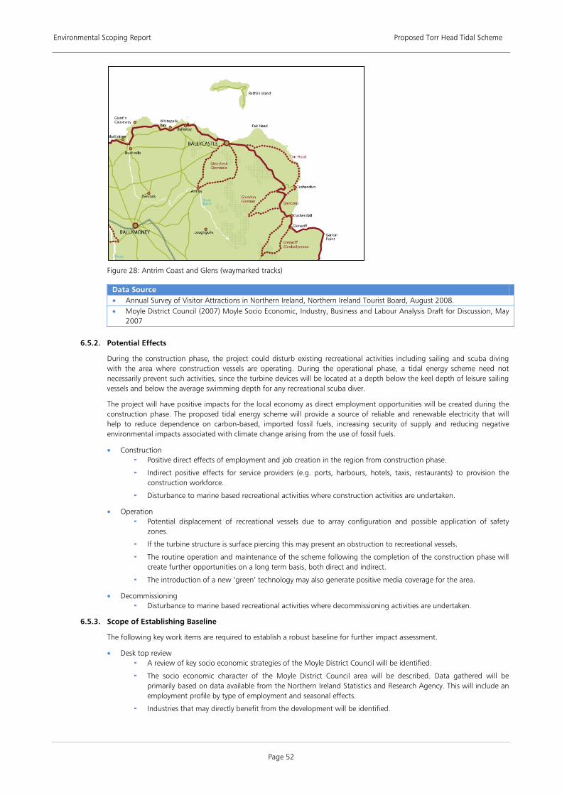
Environmental Scoping Report Proposed Torr Head Tidal Scheme
Page 52
Figure 28: Antrim Coast and Glens (waymarked tracks)
Data Source • Annual Survey of Visitor Attractions in Northern Ireland, Northern Ireland Tourist Board, August 2008. • Moyle District Council (2007) Moyle Socio Economic, Industry, Business and Labour Analysis Draft for Discussion, May
2007
6.5.2. Potential Effects
During the construction phase, the project could disturb existing recreational activities including sailing and scuba diving with the area where construction vessels are operating. During the operational phase, a tidal energy scheme need not necessarily prevent such activities, since the turbine devices will be located at a depth below the keel depth of leisure sailing vessels and below the average swimming depth for any recreational scuba diver.
The project will have positive impacts for the local economy as direct employment opportunities will be created during the construction phase. The proposed tidal energy scheme will provide a source of reliable and renewable electricity that will help to reduce dependence on carbon-based, imported fossil fuels, increasing security of supply and reducing negative environmental impacts associated with climate change arising from the use of fossil fuels.
• Construction Positive direct effects of employment and job creation in the region from construction phase.
Indirect positive effects for service providers (e.g. ports, harbours, hotels, taxis, restaurants) to provision the construction workforce.
Disturbance to marine based recreational activities where construction activities are undertaken.
• Operation Potential displacement of recreational vessels due to array configuration and possible application of safety
zones.
If the turbine structure is surface piercing this may present an obstruction to recreational vessels.
The routine operation and maintenance of the scheme following the completion of the construction phase will create further opportunities on a long term basis, both direct and indirect.
The introduction of a new ‘green’ technology may also generate positive media coverage for the area.
• Decommissioning Disturbance to marine based recreational activities where decommissioning activities are undertaken.
6.5.3. Scope of Establishing Baseline
The following key work items are required to establish a robust baseline for further impact assessment.
• Desk top review A review of key socio economic strategies of the Moyle District Council will be identified.
The socio economic character of the Moyle District Council area will be described. Data gathered will be primarily based on data available from the Northern Ireland Statistics and Research Agency. This will include an employment profile by type of employment and seasonal effects.
Industries that may directly benefit from the development will be identified.
Environmental Scoping Report Proposed Torr Head Tidal Scheme
Page 53
Descriptions of the main characteristics of the tourism industry will be developed taking into account the emphasis on sustainable tourism. Wherever possible, participation data and locations will be provided for specific activities that take place within or proximate to the preliminary assessment area. These might include yachting, sea kayaking, rib raiding, coastal walking, sea angling, diving, swimming and wildlife watching trips.
The key tourism and leisure strategies such as the Visitor Servicing Strategy for Northern Ireland, the Causeway Coast and Glens Tourism Masterplan and the Antrim Coast & Glens Area of Outstanding Natural Beauty Management Plan 2008 - 2018 will be assessed.
Statement of the nature and scale of businesses involved in the local tourism industry and specifically related to servicing coastal visits.
• Survey Work It is anticipated that no fieldwork will be required.
• Consultation will be undertaken with Moyle District council.
6.5.4. Impact Assessment
The EIA will assess the likely and significant impacts, both direct and indirect of the proposal on the regional and local economy, including tourism and leisure activities. This will include the identification of possible employment or other direct benefits to the local area and wider region from the development. The assessment will also assess the labour requirements and likely sourcing arrangements; the materials requirements and sourcing arrangements; the sourcing of the turbines themselves; and, the requirements for boat transport and boat operators – all broken down by construction phase, operational phase (circa 25 years) and decommissioning phase. The EIA will also consider local climate change impacts and the mitigation of these effects which marine energy schemes can provide.
6.5.5. Mitigation
Where appropriate and applicable, regional and local resources and services will be utilised to ensure that the project delivers local economic benefits.
6.5.6. Cumulative Impacts
Please refer to Section 7 for an initial assessment of the potential cumulative impacts in regard to socio economics and tourism.
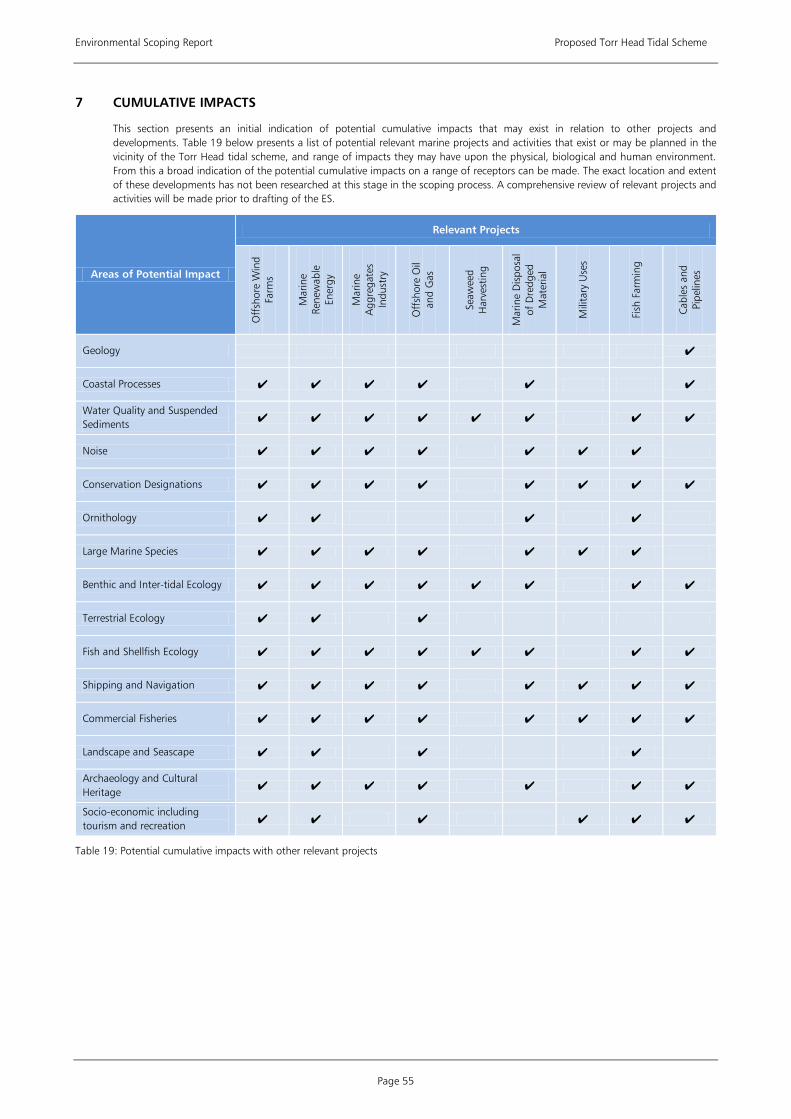
Environmental Scoping Report Proposed Torr Head Tidal Scheme
Page 55
7 CUMULATIVE IMPACTS
This section presents an initial indication of potential cumulative impacts that may exist in relation to other projects and developments. Table 19 below presents a list of potential relevant marine projects and activities that exist or may be planned in the vicinity of the Torr Head tidal scheme, and range of impacts they may have upon the physical, biological and human environment. From this a broad indication of the potential cumulative impacts on a range of receptors can be made. The exact location and extent of these developments has not been researched at this stage in the scoping process. A comprehensive review of relevant projects and activities will be made prior to drafting of the ES.
Areas of Potential Impact
Relevant Projects
Off
shor
e W
ind
Farm
s
Mar
ine
Rene
wab
le
Ener
gy
Mar
ine
Agg
rega
tes
Indu
stry
Off
shor
e O
il an
d G
as
Seaw
eed
Har
vest
ing
Mar
ine
Dis
posa
l of
Dre
dged
M
ater
ial
Mili
tary
Use
s
Fish
Far
min
g
Cabl
es a
nd
Pipe
lines
Geology
Coastal Processes
Water Quality and Suspended Sediments
Noise
Conservation Designations
Ornithology
Large Marine Species
Benthic and Inter-tidal Ecology
Terrestrial Ecology
Fish and Shellfish Ecology
Shipping and Navigation
Commercial Fisheries
Landscape and Seascape
Archaeology and Cultural Heritage
Socio-economic including tourism and recreation
Table 19: Potential cumulative impacts with other relevant projects

Environmental Scoping Report (Appendices) Proposed Torr Head Tidal Scheme
Appendix 1 Page 1
APPENDIX 1 OUTLINE SURVEY SCOPES
1) Geophysical Survey
Survey work scope
• Conduct a full geophysical survey of the study area to determine and report on the subsurface and seabed conditions in order to facilitate the construction of the tidal array. The survey should use swath bathymetry, sidescan sonar imaging, magnetometer, shallow seismic (boomer) and the collection of seabed samples for ground truthing.
• Sediment and water samples will be collected and analysed for particle size and contaminants as part of the site investigation works which support the engineering design of the array of tidal devices.
2) Metocean Conditions
Survey work scope
• Conduct detailed site specific survey work of the proposed area to fill data / information gaps and provide baseline data. Data will be required on the tidal regime, current flows, wave climate, meteorology, temperature, salinity and suspended sediment concentrations.
• Deployment ADCP current meters (number deployed will be directed by hydrodynamic modelling)
• Conduct long-term (full tidal cycle i.e. 29 day) monitoring at control and construction monitoring locations using multi-parameter sensor (turbidity, salinity, temperature).
3) Hydrodynamic Modelling
Modelling work scope
• Run computational models, which will need to be developed, calibrated and validated using data from the programme of metocean fieldwork to determine the physical conditions across the area of investigation. It is envisaged that both 2D and 3D computational modelling will be undertaken to define the physical conditions of the potential development area and in close proximity to the tidal turbine structures and for the proposed cable corridor.
• This will include the determination of near field and far field effects on wave and tidal currents in relation to representative and extreme storm events.
4) Noise
Survey work scope
• Baseline noise monitoring, if required, will be conducted in accordance with published guidance using a Type 1 sound level meter. Noise measurements may be required during both day-time and night-time hours as the tidal energy devices will be operational 24 hours.
• Measurements to ascertain underwater baseline conditions will be undertaken in appropriate and representative conditions. COWRIE methodology will be followed.
5) Ornithology
Survey work scope
• Undertake boat-based surveys of the area of investigation to ascertain species diversity, foraging behaviours, habitat utilisation and flight lines. Particular attention should be applied to those species for which the Rathlin Island SPA is designated and those which are diving species.
• It is anticipated that due to size of the area of investigation and the distance it extends offshore that boat based surveys are the most appropriate survey platform for seabird surveys.
• Vessel surveys transects will be defined and survey methods in line with Camphuysen et al. (2004).
• Surveys will be carried out monthly basis to cover key periods.
6) Large Marine Species
Survey work scope
• Undertake boat based transect surveys of the area of investigation for large marine species to ascertain species diversity, abundance and habitat utilisation.
• Visual surveys will be carried out monthly over key periods. It is envisaged these will be conducted over a period of 12 months.
• Scope and undertake static acoustic monitoring (SAM) of the area of investigation using appropriate methods (for example C-Pods).

Environmental Scoping Report (Appendices) Proposed Torr Head Tidal Scheme
Appendices Page 2
• Acoustic data will be collected continuously over key periods.
• Undertake analysis and interpretation of acoustic data to provide temporal and spatial patterns of marine mammal occurrence.
• Carry out detailed assessment of local seal haul out sites.
7) Benthic and Inter-tidal Ecology
Survey work scope
• Informed by the geophysical surveys, the benthic surveys will be carried out to characterise benthic communities throughout the area of investigation.
• Survey methods will include grab sampling where soft sediments exist. Where a hard substrate or sensitive habitats may exist remote or drop down camera will be used.
• Benthic surveys will be carried out within the area of investigation and any proposed cable corridors.
• Benthic sample protocols will follow established guidance.
• Carry out inter-tidal fieldwork during the summer months, to comprise walk-over surveys at low tide to provide characteristic information on the inter-tidal communities which will be used to inform the decision making process on potential cabling routes and landfall.
8) Terrestrial Ecology
Survey work scope
• Conduct a Phase I Habitat survey in accordance with Joint Nature Conservation Committee (JNCC) guidelines. The survey will include all areas defined for onshore works and identify habitats, fauna and field signs noted.
• Inclusion of possible breeding bird surveys.
• Based on the outcome of the extended Phase I Habitat survey, a Phase 2 Habitat survey maybe be requested and will require specialist expertise, for example badger or otter surveys.
9) Shipping and Navigation
Survey work scope
• As per MGN 371; an up to date vessel traffic radar surveys of the area concerned will be undertaken within 12 months prior to submission of the ES to identify numbers, types and sizes of vessels presently using such areas. However, if deemed necessary, to cover seasonal variations or perceived future traffic trends, the survey period may be extended to a maximum of 24 months, in which period a minimum of 42 days survey is required, and pro rata, i.e. 35 days during an 18 month period.
• Surveys will include the acquisition of both AIS and radar data to ensure coverage of all vessels types in the area.
• This will include the identification of non-transit uses of the areas, e.g. fishing, day cruising of leisure craft, commercial passenger vessels undertaking visits to the OREI, racing, aggregate dredging, etc.
• Identification of whether the area contains transit routes used by coastal or deep-draught vessels on passage.
10) Commercial Fisheries
Survey work scope
• Appoint of a locally based Fisheries Liaison Officer (FLO) to undertake a local fishery activity survey. This will include preliminary discussions with local fisheries committees and individual fisherman who fish the area to ascertain the level of use and types of gear deployed.
11) Landscape, Seascape and Visual
Survey work scope
• A site visit is required to identify any potential sensitive visual receptors.
• The site visit will also identify a number of view points from which to carry out photomontage assessment and, possibly, calculation of zones of theoretical visibility (ZTV).
12) Archaeology and Cultural Heritage
Survey work scope
• A walkover survey of the terrestrial and foreshore areas which may be impacted by the proposed development is required to identify any possible features of archaeological interest.

Environmental Scoping Report (Appendices) Proposed Torr Head Tidal Scheme
Appendix 1 Page 3
• Any marine features of interest revealed during the assessment of geophysical data may need ground truthing through diver or camera survey.
13) Onshore Works
Survey work scope (in addition to those terrestrial elements not covered in the above sections)
• Carry out a geotechnical investigation comprising sediment cores along the transect of the proposed cable landfall across the inter-tidal zone to establish the nature of the mobile sediments and beach core and to inform the design burial depth of the cables, including shore topography surveys.
• Contaminated land and groundwater assessment including borehole drilling and trial pits for inspection.
• Land use assessment including agricultural and soil resources
• Site visit to assess flood risk levels.
• Site visit to assess local transport infrastructure and traffic levels and determination of access routes and rights of way


Environmental Scoping Report (Appendices) Proposed Torr Head Tidal Scheme
Appendix 2 Page 1
APPENDIX 2 SCOPING CONSULTATION
1) Initial consultation request for information (8 September 2008) and responses from NIEA (January 2009) and other consultees
2) Consultation list
Environmental Scoping Report (Appendices) Proposed Torr Head Tidal Scheme
Appendix 2 Page 2
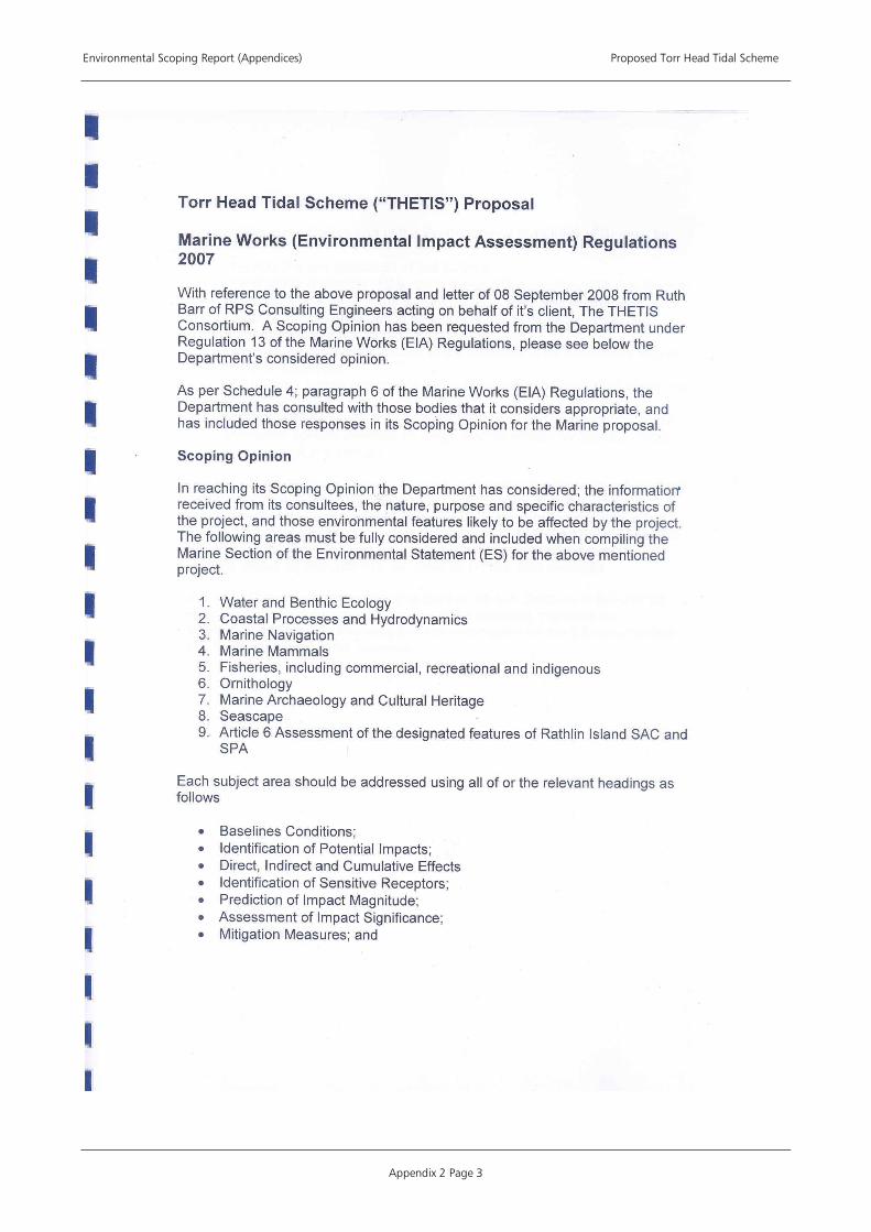
Environmental Scoping Report (Appendices) Proposed Torr Head Tidal Scheme
Appendix 2 Page 3

Environmental Scoping Report (Appendices) Proposed Torr Head Tidal Scheme
Appendix 2 Page 4
Environmental Scoping Report (Appendices) Proposed Torr Head Tidal Scheme
Appendix 2 Page 5
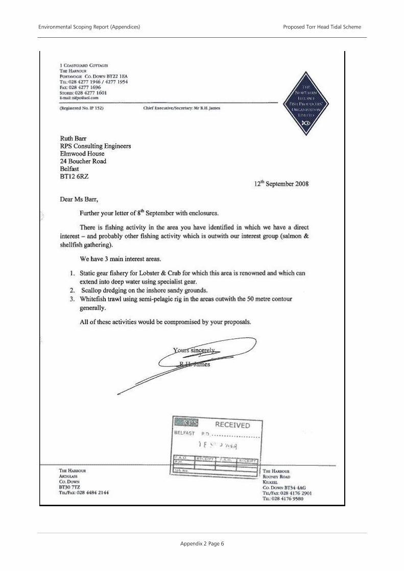
Environmental Scoping Report (Appendices) Proposed Torr Head Tidal Scheme
Appendix 2 Page 6

Environmental Scoping Report (Appendices) Proposed Torr Head Tidal Scheme
Appendix 2 Page 7

Environmental Scoping Report (Appendices) Proposed Torr Head Tidal Scheme
Appendix 2 Page 8
Environmental Scoping Report (Appendices) Proposed Torr Head Tidal Scheme
Appendix 2 Page 9

Environmental Scoping Report (Appendices) Proposed Torr Head Tidal Scheme
Appendix 2 Page 10
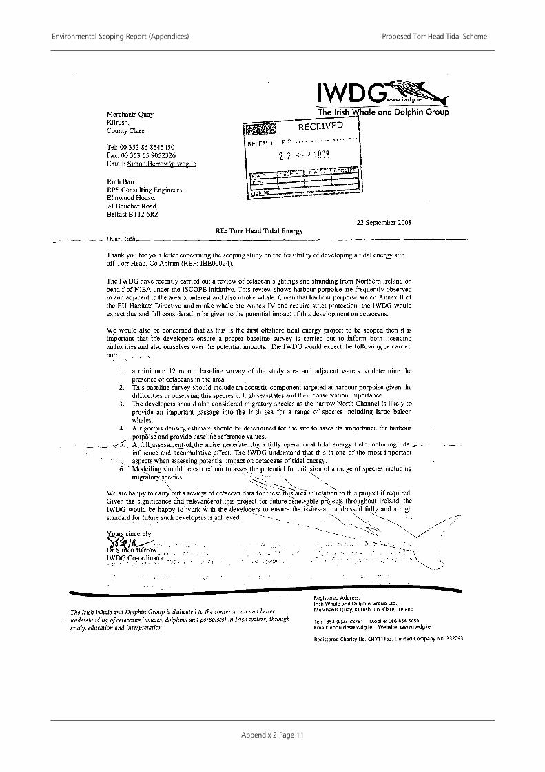
Environmental Scoping Report (Appendices) Proposed Torr Head Tidal Scheme
Appendix 2 Page 11
Environmental Scoping Report (Appendices) Proposed Torr Head Tidal Scheme
Appendix 2 Page 12

Environmental Scoping Report (Appendices) Proposed Torr Head Tidal Scheme
Appendix 2 Page 13

Environmental Scoping Report (Appendices) Proposed Torr Head Tidal Scheme
Appendix 2 Page 14

Environmental Scoping Report (Appendices) Proposed Torr Head Tidal Scheme
Appendix 2 Page 15

Environmental Scoping Report (Appendices) Proposed Torr Head Tidal Scheme
Appendix 2 Page 16

Environmental Scoping Report (Appendices) Proposed Torr Head Tidal Scheme
Appendix 2 Page 17
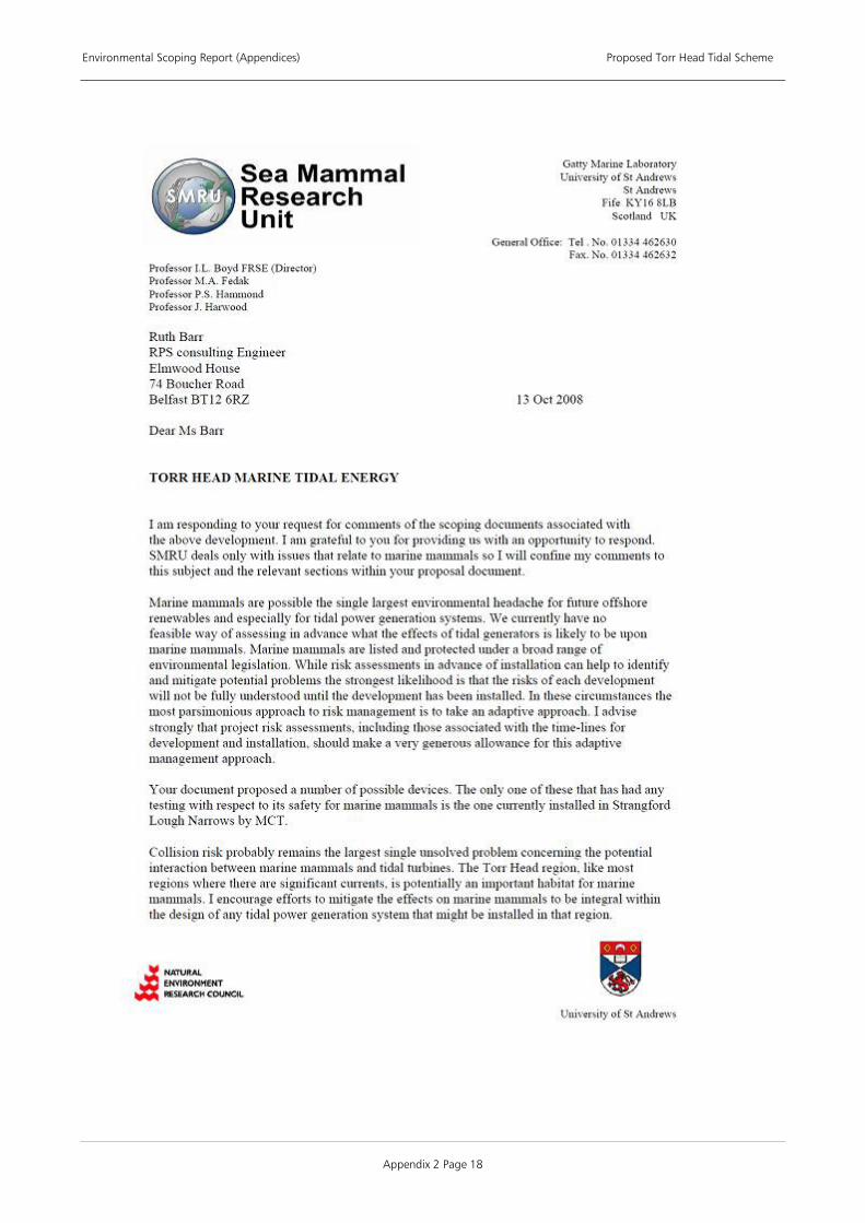
Environmental Scoping Report (Appendices) Proposed Torr Head Tidal Scheme
Appendix 2 Page 18

Environmental Scoping Report (Appendices) Proposed Torr Head Tidal Scheme
Appendix 2 Page 19
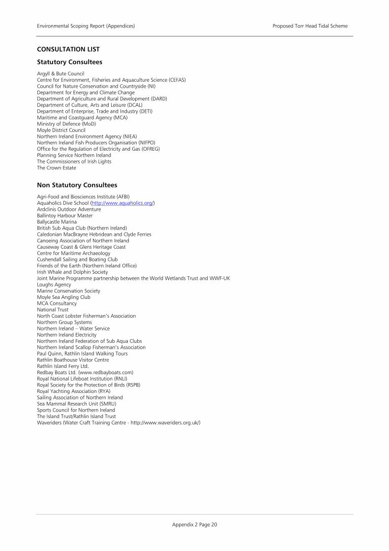
Environmental Scoping Report (Appendices) Proposed Torr Head Tidal Scheme
Appendix 2 Page 20
CONSULTATION LIST
Statutory Consultees
Argyll & Bute Council Centre for Environment, Fisheries and Aquaculture Science (CEFAS) Council for Nature Conservation and Countryside (NI) Department for Energy and Climate Change Department of Agriculture and Rural Development (DARD) Department of Culture, Arts and Leisure (DCAL) Department of Enterprise, Trade and Industry (DETI) Maritime and Coastguard Agency (MCA) Ministry of Defence (MoD) Moyle District Council Northern Ireland Environment Agency (NIEA) Northern Ireland Fish Producers Organisation (NIFPO) Office for the Regulation of Electricity and Gas (OFREG) Planning Service Northern Ireland The Commissioners of Irish Lights The Crown Estate
Non Statutory Consultees
Agri-Food and Biosciences Institute (AFBI) Aquaholics Dive School (http://www.aquaholics.org/) Ardclinis Outdoor Adventure Ballintoy Harbour Master Ballycastle Marina British Sub Aqua Club (Northern Ireland) Caledonian MacBrayne Hebridean and Clyde Ferries Canoeing Association of Northern Ireland Causeway Coast & Glens Heritage Coast Centre for Maritime Archaeology Cushendall Sailing and Boating Club Friends of the Earth (Northern Ireland Office) Irish Whale and Dolphin Society Joint Marine Programme partnership between the World Wetlands Trust and WWF-UK Loughs Agency Marine Conservation Society Moyle Sea Angling Club MCA Consultancy National Trust North Coast Lobster Fisherman’s Association Northern Group Systems Northern Ireland – Water Service Northern Ireland Electricity Northern Ireland Federation of Sub Aqua Clubs Northern Ireland Scallop Fisherman’s Association Paul Quinn, Rathlin Island Walking Tours Rathlin Boathouse Visitor Centre Rathlin Island Ferry Ltd. Redbay Boats Ltd. (www.redbayboats.com) Royal National Lifeboat Institution (RNLI) Royal Society for the Protection of Birds (RSPB) Royal Yachting Association (RYA) Sailing Association of Northern Ireland Sea Mammal Research Unit (SMRU) Sports Council for Northern Ireland The Island Trust/Rathlin Island Trust Waveriders (Water Craft Training Centre - http://www.waveriders.org.uk/)

Environmental Scoping Report (Appendices) Proposed Torr Head Tidal Scheme
Appendix 3 Page 1
APPENDIX 3 CONSERVATION DESIGNATIONS
Site Name Designated Feature
Special Protection Areas (SPAs)
Sheep Island Cormorant Phalacrocorax carbo, 249 pairs representing at least 0.6% of the breeding Northwestern Europe population
Rathlin Island Peregrine Falco peregrinus, 6 pairs representing at least 1.6% of the breeding population in Ireland
Guillemot Uria aalge, 28,064 pairs representing at least 1.2% of the breeding East Atlantic population (Seafarer Count 1985)
Razorbill Alca torda, 5,978 pairs representing at least 1.0% of the breeding population During the breeding season, the area regularly supports 66,000 individual seabirds including:
Puffin Fratercula arctica, Kittiwake Rissa tridactyla, Herring Gull Larus argentatus, Lesser Black-backed Gull Larus fuscus, Common Gull Larus canus, Fulmar Fulmarus glacialis, Razorbill Alca torda, Guillemot Uria aalge.
Larne Lough Common Tern Sterna hirundo, 180 pairs representing 5.8% of the breeding population in Ireland
Roseate Tern Sterna dougallii, 6 pairs representing 1.5% of the breeding population in Ireland Sandwich Tern Sterna sandvicensis, 165 individuals representing 3.8% of the breeding population
in Ireland Light-bellied Brent Goose Branta bernicla hrota, 227 individuals representing 1.1% of the
wintering Canada/Ireland population
Lough Foyle Bar-tailed Godwit Limosa lapponica, 1,896 individuals representing 10.8% of the wintering population in Ireland
Bewick's Swan Cygnus columbianus bewickii, 78 individuals representing 3.1% of the wintering population in Ireland
Golden Plover Pluvialis apricaria, 4,891 individuals representing 2.4% of the wintering population in Ireland
Whooper Swan Cygnus cygnus, 890 individuals representing 8.9% of the wintering population in Ireland
Light-bellied Brent Goose Branta bernicla hrota, 3,730 individuals representing 18.6% of the wintering Canada/Ireland population
Over winter, the area regularly supports 37,310 individual waterfowl (5 year peak mean 1991/2 - 1995/6) including: Teal Anas crecca, Whooper Swan Cygnus cygnus, Golden Plover Pluvialis apricaria, Bar-tailed Godwit Limosa lapponica, Light-bellied Brent Goose Branta bernicla hrota, Great Crested Grebe Podiceps cristatus, Cormorant Phalacrocorax carbo, Greylag Goose Anser anser, Bewick's Swan Cygnus columbianus bewickii, Wigeon Anas penelope, Redshank Tringa totanus, Mallard Anas platyrhynchos, Eider Somateria mollissima, Red-breasted Merganser Mergus serrator, Oystercatcher Haematopus ostralegus, Lapwing Vanellus vanellus, Knot Calidris canutus, Dunlin Calidris alpina alpina, Curlew Numenius arquata, Shelduck Tadorna tadorna.
Kintyre Goose Roosts Greenland White-fronted Goose Anser albifrons flavirostris, 2,323 individuals representing at least 16.6% of the wintering population in Great Britain
Special Areas of Conservation (SACs)
Rathlin Island Reefs Vegetated sea cliffs of the Atlantic and Baltic coasts Submerged or partially submerged sea caves Sandbanks which are slightly covered by sea water all the time Annual vegetation of drift lines Common Seal and Grey Seal are both Grade D species at this site.
North Antrim Coast Vegetated sea cliffs of the Atlantic and Baltic coasts Annual vegetation of drift lines Atlantic salt meadows (Glauco-Puccinellietalia maritimae) Shifting dunes along the shoreline with Ammophila arenaria (`white dunes`) Fixed dunes with herbaceous vegetation (`grey dunes`) Species-rich Nardus grassland, on siliceous substrates in mountain areas (and submountain areas
in continental Europe) Narrow-mouthed whorl snail
Bann Estuary Fixed dunes with herbaceous vegetation (`grey dunes`) Atlantic salt meadows (Glauco-Puccinellietalia maritimae) Embryonic shifting dunes Shifting dunes along the shoreline with Ammophila arenaria (`white dunes`)
Luce Bay and Sands Grey Seal listed as Grade D species at this site
South-East Islay Skerries Common Seal
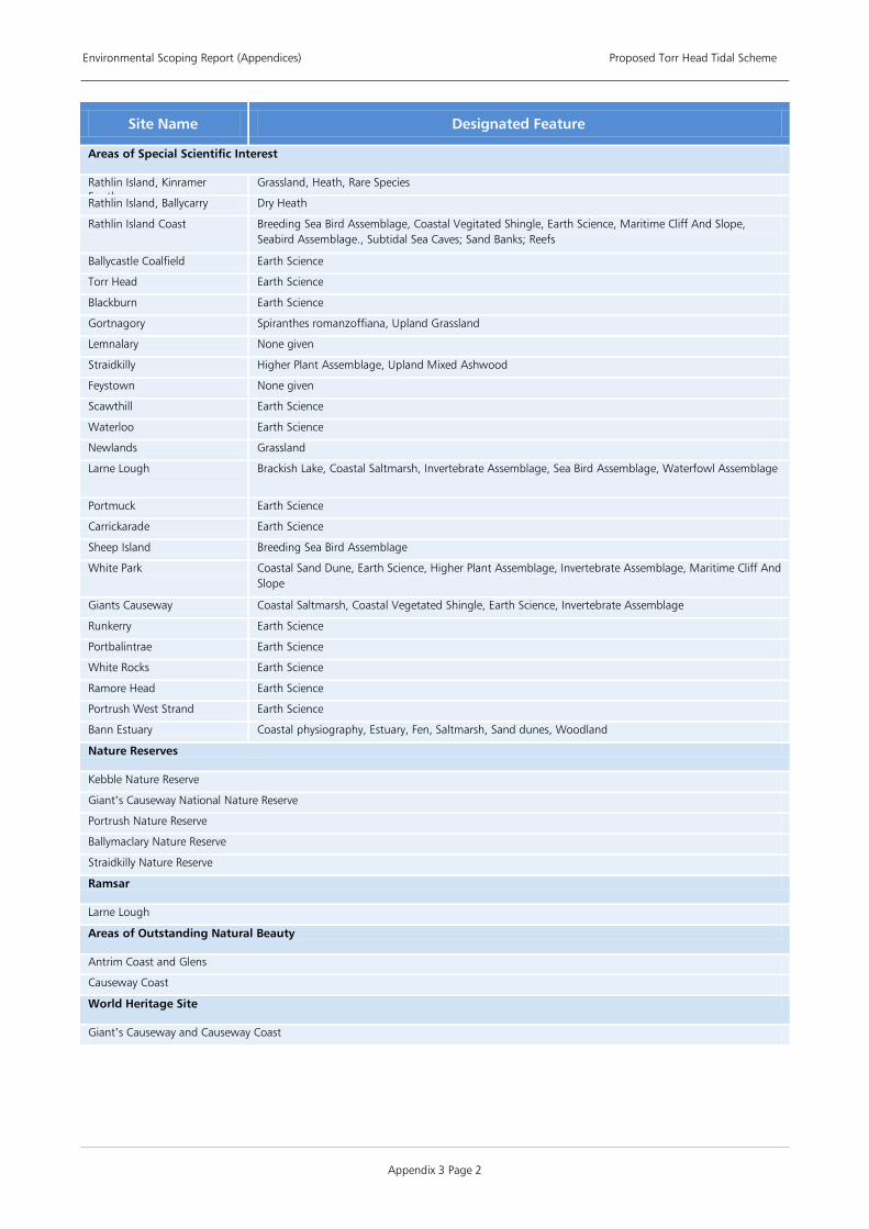
Environmental Scoping Report (Appendices) Proposed Torr Head Tidal Scheme
Appendix 3 Page 2
Site Name Designated Feature
Areas of Special Scientific Interest
Rathlin Island, Kinramer South
Grassland, Heath, Rare Species
Rathlin Island, Ballycarry Dry Heath
Rathlin Island Coast Breeding Sea Bird Assemblage, Coastal Vegitated Shingle, Earth Science, Maritime Cliff And Slope, Seabird Assemblage., Subtidal Sea Caves; Sand Banks; Reefs
Ballycastle Coalfield Earth Science
Torr Head Earth Science
Blackburn Earth Science
Gortnagory Spiranthes romanzoffiana, Upland Grassland
Lemnalary None given
Straidkilly Higher Plant Assemblage, Upland Mixed Ashwood
Feystown None given
Scawthill Earth Science
Waterloo Earth Science
Newlands Grassland
Larne Lough Brackish Lake, Coastal Saltmarsh, Invertebrate Assemblage, Sea Bird Assemblage, Waterfowl Assemblage
Portmuck Earth Science
Carrickarade Earth Science
Sheep Island Breeding Sea Bird Assemblage
White Park Coastal Sand Dune, Earth Science, Higher Plant Assemblage, Invertebrate Assemblage, Maritime Cliff And Slope
Giants Causeway Coastal Saltmarsh, Coastal Vegetated Shingle, Earth Science, Invertebrate Assemblage
Runkerry Earth Science
Portbalintrae Earth Science
White Rocks Earth Science
Ramore Head Earth Science
Portrush West Strand Earth Science
Bann Estuary Coastal physiography, Estuary, Fen, Saltmarsh, Sand dunes, Woodland
Nature Reserves
Kebble Nature Reserve
Giant’s Causeway National Nature Reserve
Portrush Nature Reserve
Ballymaclary Nature Reserve
Straidkilly Nature Reserve
Ramsar
Larne Lough
Areas of Outstanding Natural Beauty
Antrim Coast and Glens
Causeway Coast
World Heritage Site
Giant’s Causeway and Causeway Coast

Environmental Scoping Report (Appendices) Proposed Torr Head Tidal Scheme
Appendix 4 Page 1
APPENDIX 4 PROPOSED STRUCTURE OF ENVIRONMENTAL STATEMENT
Volume 1: Non Technical Summary
Volume 2: ES Final Report
1) Introduction 1.1. The Proposed Development 1.2. The Developer 1.3. The Project 1.4. Statutory Consents and Permissions 1.5. Need for the Project 1.6. Effects of Climate Change 1.7. Emissions Offset 1.8. Project Team
2) Environmental Impact Assessment
2.1. EIA Process 2.2. Terminology 2.3. Strategic Environmental Assessment 2.4. Regulatory Context 2.5. Impact Assessment Methodology 2.6. Best Practice 2.7. Structure of the Environmental Statement 2.8. Technical Reports
3) Scoping 3.1. Introduction 3.2. Project Scoping 3.3. Consultation During Scoping 3.4. Summary of Scoping Responses 3.5. Scoping of Cumulative and In-combination Effects
4) Consultation 4.1. Introduction 4.2. Methods of Communication 4.3. Project Briefing 4.4. Public Consultation 4.5. Consultation Register
5) Regulatory and Policy Context 5.1. Statutory Consents and Permissions 5.2. Requirement for Environmental Impact Assessment 5.3. Marine Energy in the UK 5.4. Summary of Regulation and Policy 5.5. Conclusion
6) Description of the Project 6.1. Introduction 6.2. Objectives of the Development 6.3. Site Location 6.4. Physical Characteristics 6.5. Offshore Components and their Installation 6.6. Offshore Construction 6.7. Onshore Components and their Installation 6.8. Onshore Construction 6.9. Marine Current Array Operations and Maintenance 6.10. Marine Current Array Decommissioning
7) Site Selection and Assessment of Alternatives 7.1. Introduction 7.2. Offshore Site Selection Process

Environmental Scoping Report (Appendices) Proposed Torr Head Tidal Scheme
Appendix 4 Page 2
7.3. Grid Connection 7.4. Assessment of Alternative Cable Landfalls, Onshore Routes and Sub-stations
8) Relevant Projects 8.1. Introduction 8.2. Offshore Energy Projects 8.3. Marine Aggregate Extraction 8.4. Subsea Cables and Pipelines 8.5. Offshore Oil and Gas 8.6. Disposal of Dredged Material 8.7. Ports and Harbours
9) Physical Environment 9.1. Coastal Processes 9.2. Geology 9.3. Water Quality and Suspended Sediments 9.4. Noise
10) Biological Environment 10.1. Conservation Designations 10.2. Ornithology 10.3. Large Marine Species 10.4. Benthic and Inter-tidal Ecology 10.5. Fish and Shellfish Ecology
11) Human Environment 11.1. Shipping and Navigation 11.2. Commercial Fisheries 11.3. Seascape 11.4. Marine Archaeology and Cultural Heritage 11.5. Socio-economic including Tourism and Recreation
12) Onshore Works
12.1. Hydrological, Hydrogeology and Flood Risk 12.2. Geology, Soils and Land use 12.3. Noise 12.4. Terrestrial Ecology 12.5. Ornithology 12.6. Landscape and Visual 12.7. Archaeology and Cultural Heritage 12.8. Traffic, Access and Rights of Way 12.9. Socio-economic including Tourism and Recreation
13) Conclusions 13.1. Physical Environment 13.2. Biological Environment 13.3. Human Environment 13.4. Onshore works
Volume 3: Drawings and Figures
Volume 4: Appendices


THETIS ENERGY LTD
Registered office: Capital House, 3 Upper Queen Street, Belfast BT1 6PU
B9 Energy Offshore Developments Ltd Willowbank Road, Larne, County Antrim BT40 2SF http://www.b9energy.co.uk Deepblue Renewables Ltd Unit 12, Galway Technology Park, Parkmore, Galway, Ireland http://www.deepbluerenewables.com Statkraft UK Ltd 26-28 Hammersmith Grove, London W6 7BA http://www.statkraft.com