Embed Size (px)
Citation preview

2007
New Windsor Community
Comprehensive Plan
Adopted by the New Windsor Mayor and Council as of
July 5, 2007
REVISED October 14, 2008
AMENDED
December 20, 2010


New Windsor Community Comprehensive Plan
i
Table of Contents
Chapter 1: Introduction 1 Plan Definition and Purpose 1 Planning Commission Responsibility 3 State Legislation 4 Meeting the Eight Visions 8
Chapter 2: Plan Foundation 11 Maryland’s Eight Visions 11 Carroll County’s Vision 11 Carroll County’s Goals 12 New Windsor Community Planning Area’s Vision 13 New Windsor Community Comprehensive Plan Goals 14 Plan Structure 16 Terms Used 16 Public Participation 19
Chapter 3: Review Findings and Major Concepts 21 Summary of Current Plan Review 21 Progress Achieving Smart Growth Principles 21 Summary of New Legislation 22 Discussion of New Development Issues 22
Chapter 4: Demographics & Projections 25 Census and Other Data 25 Population Projections 30
Chapter 5: Land Use and Growth Management 33 Goals 33 Current Conditions 33 Analysis of Community Needs 42 Recommended Actions 44 Fiscal Implications 48
Chapter 6: Municipal Growth 51 Municipal Growth 51
Chapter 7: Transportation 73 Goals 73 Current Conditions 73 Analysis of Community Needs 79 Recommended Actions 81 Fiscal Implications 85
Chapter 8: Community Facilities 89 Goals 89 Current Conditions 89 Analysis of Community Needs 98 Recommended Actions 101 Fiscal Implications 104
Chapter 9: Natural & Agricultural Resources 107 Goal 107 Current Conditions 107 Analysis of Community Needs 112

New Windsor Community Comprehensive Plan
ii
Recommended Actions 112 Fiscal Implications 114
Chapter 10: Economic Development & Activity 115 Goal 115 Current Conditions 115 Analysis of Community Needs 120 Recommended Actions 122 Fiscal Implications 128
Chapter 11: Historic & Cultural Resources 133 Goals 133 Current Conditions 133 Analysis of Community Needs 139 Recommended Actions 140 Fiscal Implications 144
Chapter 12: Community Involvement 147 Goals 147 Current Conditions 147 Analysis of Community Needs 151 Recommended Actions 152 Fiscal Implications 153
Chapter 13: Interjurisdictional Coordination & Communication 155 Goal 155 Current Conditions 155 Analysis of Community Needs 160 Recommended Actions 160 Fiscal Implications 161
Chapter 14: Housing & Community Design 163 Goals 163 Current Conditions 163 Analysis of Community Needs 168 Recommended Actions 169 Fiscal Implications 170
Chapter 15: 2007 Land Use Designations 171
Maps Map 1 - 1997 Land Use Designations Map 2 - Publicly Owned Land Map 3 - Agricultural Preservation and Land Trust Easements Map 4 - Existing Use of Land Map 5 - Existing Zoning Map 6 - Priority Funding Area Map 7 - Municipal Growth Map 8 - Parks & Local Circulation Map 9 - Community Facilities Map 10A - Current Water Service Area Map 10B - Proposed Water Service Area Map 11A - Current Sewer Service Area Map 11B - Proposed Sewer Service Area Map 12 - Environmental Resources Map 13 - Mineral Resource Overlay Area Map 14 - Historic and Cultural Resources Map 15 - 2007 Land Use Designations Map 16 - Community Comprehensive Plan
New Windsor Community Comprehensive Plan
1
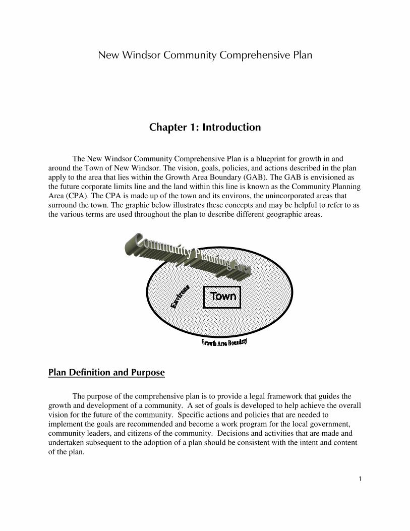
Chapter 1: Introduction The New Windsor Community Comprehensive Plan is a blueprint for growth in and
around the Town of New Windsor. The vision, goals, policies, and actions described in the plan apply to the area that lies within the Growth Area Boundary (GAB). The GAB is envisioned as the future corporate limits line and the land within this line is known as the Community Planning Area (CPA). The CPA is made up of the town and its environs, the unincorporated areas that surround the town. The graphic below illustrates these concepts and may be helpful to refer to as the various terms are used throughout the plan to describe different geographic areas.
Plan Definition and Purpose
The purpose of the comprehensive plan is to provide a legal framework that guides the growth and development of a community. A set of goals is developed to help achieve the overall vision for the future of the community. Specific actions and policies that are needed to implement the goals are recommended and become a work program for the local government, community leaders, and citizens of the community. Decisions and activities that are made and undertaken subsequent to the adoption of a plan should be consistent with the intent and content of the plan.

New Windsor Community Comprehensive Plan
2
VISION OR VISION STATEMENT - A vision is a statement that defines a community’s preferred future. To choose a direction, a community must first develop a mental image of a possible and desirable future state. This vision should articulate a feasible, achievable, realistic, and attractive future for the community, which should be a future that is better than that of existing conditions. The process of developing a vision not only helps to define the community’s preferences and desires for the future but also helps to empower members of the community. A shared vision builds community between the public and private, the leaders, and the residents. It encourages cooperation and coordination among the stakeholders. It is also easier to establish priorities when community leaders know what end they are working toward. The defined vision must become an integral part of the management and operation of the local government(s) and the activities in which residents participate. The purpose of this vision statement is to serve as a guide that community leaders and decision makers use as a basis for the decisions made and activities undertaken.
GOALS - A goal identifies the purpose toward which an endeavor is directed. Goals are broad statements of intended accomplishments which, if achieved as a whole, would bring the community closer to meeting its overall vision of the future. They do not identify specific activities that will be undertaken. Rather, they identify a set of objectives designed to guide the community toward meeting its goals.
POLICIES - A policy identifies the course of action to be taken when presented with a decision to be made on a given issue. To fulfill its role as a guidance tool, policy statements are included in the plan. These policy statements express the community's desires for future decisions and help to guide the achievement of the goals they have developed. The policies indicate the direction that decision-makers would take when decisions are to be made regarding county services and land use development. The policy statements are based on an overall set of goals for the community and its future.
ACTIONS - An action is a recommended activity to help bring a community closer to achieving its goal(s). Goals help to identify where a community wants to be and toward what they are striving. However, they do not identify specific things that can be done to help the community get there. Actions are planning, land use, and general government-related activities that can be pursued, ideally as a whole and in combination with the recommended policies, to help the community meet its goals. Actions are often referred to as objectives or implementation measures.
The comprehensive plan for a specific community within Carroll County, a small area plan called a “community comprehensive plan,” gives that community the opportunity to study in more detail the factors which influence its area and provides more direction on what the community hopes to accomplish beyond what the County Comprehensive Plan addresses. Individual properties can be reviewed, specific areas can be designated for revitalization, and unique functional plan elements can be developed to apply to these small areas. These more

New Windsor Community Comprehensive Plan
3
detailed activities and items would not normally be addressed in the County Comprehensive Plan.
As a comprehensive plan addresses more than just land uses and zoning, the community comprehensive plan gives a community the opportunity to address such issues as economic development, community involvement, park facilities, and historic resources, among other things. These issues can and should be addressed regardless of whether the community ultimately decides to make changes to the existing land use designation map or zoning districts.
The Plan contained herein presents a set of goals that address the issues of growth management and land use, transportation, community facilities, natural resources, economic development and activity, historic/cultural resources, community involvement, interjurisdictional coordination and communication, and housing and community design. The chapters around which these issues are organized each share common components. They all discuss current conditions, an analysis of community needs, recommended policies and actions, fiscal implications, and anticipated Community Investment Plan (CIP) projects. These components, which encompass more of the community’s needs than they often have in the past, will be consistent among all the community comprehensive plans as they are updated. Through incorporating a fiscal implications and related CIP projects component, the community will have a plan that is more realistic and better represents what the citizens are willing to accept.
Planning Commission Responsibility
Traditionally, the Planning Commission consists of members of the public at large, who reside in that particular jurisdiction, with little or no formal training in planning. Article 66B authorizes municipalities and counties to create a Planning and/or Zoning Commission made up of five to seven members, one of whom may be a member of the local legislative body to serve in an ex-officio capacity concurrent with his or her official term. Members are appointed by the Mayor or Board of County Commissioners to serve a term of five years, with members' terms staggered so that terms end at different times. Removal of a member may only occur by the legislative body through a public hearing process and filing of a written statement demonstrating inefficiency, neglect of duty, and/or malfeasance in office. The idea of appointing a group of lay people to make decisions and recommendations about land use planning came about to reduce political influence on decisions.
The purpose of the Planning Commission is to serve as advisor to the elected officials, the Town Council or Board of County Commissioners, on land use planning and to review matters related to planning and development. The Commission holds a meeting open to the public on a regular monthly basis to consider land use issues. One of the most significant responsibilities that the Planning Commission is given is the authority to develop the county or town’s comprehensive plan. Upon completion of a final draft acceptable to the Commission, the

New Windsor Community Comprehensive Plan
4
members will vote to approve the Plan and will forward it to the elected officials with a recommendation for adoption. The elected officials have the authority to accept or reject this recommendation. While the elected officials cannot make revisions to the Plan themselves, they may send it back to the Planning Commission to make suggested modifications.
The Planning Commission is also empowered with original jurisdiction for the review and approval of subdivision. It is also responsible to develop and approve subdivision regulations which must be adopted by the elected officials in their respective jurisdictions in order to become effective. As with comprehensive plans, the Council or Commissioners may not make changes to the proposal. If the elected officials disapprove the proposal for adoption, they may only send the proposal back to the Commission for revisions. Since the Commission focuses on planning issues, it is a valuable intermediary between the public and the elected officials.
The Planning Commission also makes recommendations to the elected officials on
proposals relating to zoning or rezoning. The elected officials have the authority to accept, reject, or modify those recommendations.
Planners are the Commission's research staff. Several of the county’s municipalities have
a planner on staff. In these cases, the county provides a liaison comprehensive planner to serve in an advisory role and to foster cooperation between the jurisdictions. Many of the municipalities, however, do not employ their own planners. In these cases, the county liaison comprehensive planner also serves as planner for the town and its Planning Commission. The planner advises the Commission on the comprehensive plan, development plans, zoning ordinance, subdivision regulations, and other miscellaneous planning issues. In addition, the planning staff may provide background information and recommendations on the proposals that are under the Commission's consideration and answer technical questions. The liaison planner attends all of the regularly scheduled Planning Commission meetings.
State Legislation
1 Article 66B of the Annotated Code of Maryland
Article 66B, added to the Maryland Code in 1927 and now entitled Zoning and Planning, delegates basic planning and land use regulatory powers to the state's municipalities, Baltimore City, and non-charter counties. Important sections of Article 66B apply to charter counties as well.
Under Article 66B, it is the function and duty of the Planning Commission to develop, with help of staff, and approve a plan which will be recommended to the local legislative body
New Windsor Community Comprehensive Plan
5
for adoption. This required plan serves as a guide to all public and private actions and decisions to ensure that development of public and private property occurs in appropriate relation to each other. This Plan document satisfies the requirement to provide a statement of goals and objectives, principles, policies, and standards which shall serve as a guide for the development and economic and social well being of the jurisdiction.
2 Economic Growth, Resource Protection, and Planning Act of 1992
On October 1, 1992, the Maryland Economic Growth, Resource Protection, and Planning Act of 1992 (the Planning Act) was passed with the intent of encouraging economic growth, limiting sprawl development, and protecting the state's natural resources. The Planning Act amends Article 66B. Most local jurisdictions in the state have established priority areas for resources protection. The Planning Act encourages these jurisdictions to build on that base with consistent development regulations and targeted infrastructure investment by the state.
A premise of the Act is that the comprehensive plans prepared by counties and towns are the best place for local governments to establish priorities for growth and resource conservation, and that once those priorities are established, it is the state's responsibility to back them up.
The Planning Act is based on eight "Visions." County and municipal plans are required to be amended so that the plans implement an established set of policies, which should be based on the Visions. The Visions are stated in the Act as follows:
VISION 1 Development is concentrated in suitable areas.
VISION 2 Sensitive areas are protected. VISION 3 In rural areas, growth is directed to existing population centers and
resources areas are protected. VISION 4 Stewardship of the Chesapeake Bay and the land is a universal ethic.
VISION 5 Conservation of resources, including a reduction in resource consumption, is practiced.
VISION 6 To assure the achievement of 1 through 5 above, economic growth is encouraged and regulatory mechanisms are streamlined.
VISION 7 Adequate public facilities and infrastructure under the control of the county or municipal corporation are available or planned in areas where growth is to occur.
VISION 8 Funding mechanisms are addressed to achieve these visions. Making the Visions part of Maryland's planning and zoning enabling legislation gives
local jurisdictions a concise statement of Maryland's priorities for their plans. Local Planning Commissions must now review, and if necessary, amend their plans at regular six-year intervals. Until the adoption of the Planning Act, there had been no statewide requirement that local

New Windsor Community Comprehensive Plan
6
jurisdictions review their plans on a regular basis. This provision ensures that plans are frequently reconsidered in light of new needs.
3 Smart Growth and Neighborhood Conservation Act of 1997
The 1997 General Assembly adopted several specific programs, which together form the Smart Growth initiatives. Under these initiatives, counties may designate areas as Priority Funding Areas if they meet guidelines for intended use, availability of plans for sewer and water systems, and permitted residential density. The state will not put their funds where development is low in density; there must be an average density of 3.5 dwelling units per acre to qualify for state funds. Existing communities and areas where industrial or other economic development is desired are the areas that are eligible for county designation. Counties may also designate areas planned for new residential communities which will be served by water and sewer systems and meet density standards. As of October 1, 1998, the state is prohibited from funding growth-related projects not located in a Priority Funding Area.
Smart Growth also establishes a Rural Legacy program to preserve sensitive rural areas and to help jurisdictions purchase agricultural land easements, a brownfields program to encourage redevelopment, a Job Creation Tax Credit to promote revitalization, and a Live Near Your Work program to promote settling in older urban areas.
4 HB 1141, HB 2 and HB 1160
The 2006 session of the Maryland General Assembly produced three notable bills related to land use planning and the comprehensive plan, HB 1141, HB 2, and HB 1160. The new legislation requires four new plan elements, though some may only apply to the County and others may only apply to municipalities. These elements are: a Water Resources Element; a Municipal Growth Element; a Priority Preservation Area Element; and a Workforce Housing Element.
The WATER RESOURCES ELEMENT is designed to express the relationship between planned growth, as identified in the plan, and the water resources that will serve and be affected by it. The Water Resources Element will:
• Identify drinking water and other water resources adequate for the needs of existing and future development proposed in the land use element of the comprehensive plan; and,
• Identify suitable receiving waters for both wastewater and stormwater management to meet the needs of existing and projected development proposed in the land use element of the comprehensive plan.

New Windsor Community Comprehensive Plan
7
• This element must be included in the comprehensive plan no later than October 1, 2009.
The MUNICIPAL GROWTH ELEMENT requires municipalities to identify future growth areas
that will implement their long-range vision for the future. These areas are to be based upon population projections, an assessment of land capacity and needs, and an assessment of infrastructure and sensitive areas, among other things. The element should be done in conjunction with the County, since it will guide future annexations, a process involving both jurisdictions. This element must be included in municipal comprehensive plans no later than October 1, 2009 as well.
The PRIORITY PRESERVATION AREA ELEMENT, addressed in HB 2, is required of the County to
maintain its certification of its agricultural land preservation program. This element requires that the County identify priority preservation areas based upon the productivity of and/or profitability of agricultural and forestry enterprises, and that policies be in place in these areas to prevent them from being converted to or compromised by development. The acreage goal for land in a priority preservation area to be preserved through easements and zoning must equal at least 80 percent of the undeveloped land within the area. Counties also must demonstrate in future plan updates how they are contributing towards the statewide preservation goals of the Maryland Agricultural Land Preservation Foundation and what they can do to address any shortcomings. In order to maintain certification, the Priority Preservation Area element must be included in the County comprehensive plan by July 1, 2008.
The fourth element is only required of local governments if they wish to be eligible for
participation in the Workforce Housing Grant Program, which was established in 2006 by HB 1160. The WORKFORCE HOUSING ELEMENT should assess workforce housing needs and contain goals, objectives, and policies to preserve or develop workforce housing. “Workforce housing” is defined in the bill as rental housing that is affordable to households with an annual income between 50 percent and 100 percent of the area median income, or homeownership housing that is affordable to households with an annual income between 60 percent and 120 percent of the median income. Measures that could be included in the element to address workforce housing include:
• Preservation and renovation of existing housing stock
• Redevelopment of existing residential areas
• Streamlined regulatory processes and reduced regulatory fees for construction or renovation
• Financial incentives for construction and renovation including local property tax credits
• Special zoning regulations for construction and renovation including inclusionary zoning
• Efforts to preserve workforce housing stock for subsequent first-time homebuyers and

New Windsor Community Comprehensive Plan
8
renters
• Coordination with neighboring jurisdictions
• Coordination with private sector employers • Leveraging of federal financial assistance
• No date for inclusion of this element in the local plan has been established. HB 1141 also resulted in several changes to annexations and rezonings. Any annexations
that take place after October 1, 2009 must be consistent with the municipal growth element. Additionally, as of October 1, 2006 all annexation proposals must contain an “annexation plan,” which is simply the new name for the outline for the extension of services and public facilities that has been required in the past. The annexation plan must be provided to the County and the State (Maryland Department of Planning) 30 days prior to the public hearing for their review and comment.
Another change that applies to annexations relates to the “five-year rule.” Previously
under this rule, unless a zoning waiver was obtained from the County the zoning on an annexed property could not be changed for five years if the desired zoning was substantially different from that envisioned in the master plan (comprehensive plan). This requirement no longer applies unless the proposed zoning is more dense than the current County zoning by 50 percent or more. A municipality still may request a waiver of zoning from the County to avoid waiting five years. This change became effective on October 1, 2006.
Changes also were made to the Priority Funding Area criteria. Beginning October 1,
2006, municipalities must base their Priority Funding Areas on an analysis of the capacity of land available for development, in-fill, or redevelopment and an analysis of the land area needed to satisfy demand for development at densities consistent with the master plan.
If all of the elements required are not in place on or before October 1, 2009, the affected
jurisdiction (County or Town) “may not change the zoning classification of a property until that county or municipal corporation” is in compliance.
Meeting the Eight Visions
The 2007 New Windsor Community Comprehensive Plan implements the Eight Visions in the Planning Act. Development is concentrated in suitable areas, and, in rural areas, growth is directed to existing population centers and resource areas are protected. The suitable areas for development in Carroll County are the Community Planning Areas, or CPA’s. The CPA’s are areas of the county for which a more detailed plan is prepared. These areas are also usually designated to accept new growth. Public water and sewer services are generally provided here, along with other services. Most of the CPA’s are centered on an incorporated municipality, which has been in existence since the turn of the century or longer, where densities
New Windsor Community Comprehensive Plan
9
are higher than in the rural areas, and which boasts historic qualities. The County actively pursues the preservation of agricultural land as a basic premise on
which other planning efforts are focused. Preservation of agricultural land helps to protect the resource lands as well as encourage growth to locate where services are available.
The plan also demonstrates that sensitive areas are protected and stewardship of the Chesapeake Bay and the land is a universal ethic. In addition to making good use of the land through preserving agriculture and concentrating growth in designated areas, the plan suggests actions that can be taken to achieve the goal of preserving environmental resources. Innovative and resourceful community design and provision of measures to further protect the water supply are among the many recommendations the community will consider to use the land efficiently and to reduce and mitigate the impacts of development on environmental resources. These activities, as well as the previously-mentioned land preservation efforts, show that conservation of resources, including a reduction in resource consumption, is practiced in Carroll County.
Economic development is a vital part of Carroll’s economy and tax base. The Carroll
County Master Plan (comprehensive plan) addresses measures to ensure that economic growth is encouraged and regulatory mechanisms are streamlined. A threshold for the county to maintain its industrial and commercial tax base has been identified. The goal is for commercial and industrial uses to represent a minimum of 12 percent of the tax base as new development occurs, as it will help the County provide needed services and the economic development will bring jobs to the county. Additionally, the County has been implementing numerous streamlining measures to make the regulatory process more efficient, more user-friendly, and more effective.
The plan provides measures to ensure that adequate public facilities and infrastructure under the control of the County or municipal corporation are available or planned in areas where growth is to occur. The County provides many of the facilities and services needed by the residents of the New Windsor Community Planning Area. The County adopted a Concurrency Management Ordinance. This program is designed to phase and time growth and public facilities through the County’s CIP. Any planned residential growth within the county is permitted to proceed at a rate that will not unduly strain public facilities, especially schools, roads, water and sewer facilities, and police, fire, and emergency medical services. The Town also updated their Adequate Public Facilities Ordinance to address these same issues on the municipal level in January of 2003.
The eighth vision, funding mechanisms have been addressed to achieve the visions, is achieved through the creative use of the annual CIP, the Town-County Agreement, Concurrency Management, and other implementation recommendations. Allocating adequate funding for land acquisition and preservation, economic development opportunities, and revenue sharing with the County further assures the attainment of this vision.


New Windsor Community Comprehensive Plan
11
Chapter 2: Plan Foundation
Maryland’s Eight Visions
As discussed in Chapter 1, the 1992 Planning Act is based on eight visions. County and municipal plans are required to be amended so that the plans implement an established set of policies, which should be based on the Visions. Chapter 1 describes how this community comprehensive plan meets and is consistent with these Eight Visions. Again, these visions are stated in the Act as follows:
VISION 1 Development is concentrated in suitable areas. VISION 2 Sensitive areas are protected. VISION 3 In rural areas, growth is directed to existing population centers and
resources areas are protected. VISION 4 Stewardship of the Chesapeake Bay and the land is a universal ethic. VISION 5 Conservation of resources, including a reduction in resource consumption,
is practiced. VISION 6 To assure the achievement of 1 through 5 above, economic growth is
encouraged and regulatory mechanisms are streamlined. VISION 7 Adequate public facilities and infrastructure under the control of the
county or municipal corporation are available or planned in areas where growth is to occur.
VISION 8 Funding mechanisms are addressed to achieve these visions.
Carroll County’s Vision
Through the process of developing the 2000 County Master Plan, the work teams, representing each municipality and many other diverse interests, supported the following vision statement for the county.
Carroll County offers a safe environment in which all its citizens may reside, work, shop,
learn, and play. The rural character of our county is preserved through measures that
protect our natural and cultural resources, minimize residential sprawl, and save
farmland. Carroll County is enriched by sustainable agriculture and agribusiness as

New Windsor Community Comprehensive Plan
12
well as retention and recruitment of responsible, productive business and industry that
offer family-wage jobs and employ the existing skilled workforce in the county. Adequate
public facilities will be provided as Capital Improvement Program funding is available
and concurrent with timed and phased development demand.
Carroll County’s Goals
The goals developed to help achieve the county vision address multiple aspects of the countywide community. They are broad enough to be applicable countywide. All of the functional and small area (detailed) plans developed within the county strive to achieve and to be consistent with these overall goals.
GOAL 1 Direct new development to the designated growth areas to protect and conserve agricultural and environmental resource areas, preserve open space, and provide public facilities and services efficiently and cost effectively.
GOAL 2 Preserve agricultural land for the production of agricultural products and promotion of related agribusiness.
GOAL 3 Protect, maintain, and restore, where practical, the environmental resources and natural ecosystems in the county by promoting land use practices that are in balance with, and minimize the effects on, the natural environment.
GOAL 4 Promote a healthy economy and additional employment opportunities by 1) supporting the retention and expansion of existing businesses including agribusiness through sensible land use policies and 2) providing land appropriately located and zoned for a variety of types and intensities of new economic development activities.
GOAL 5 Phase and time development at a rate consistent with the county’s ability to fund and expand community services and facilities through public and private resources.
GOAL 6 Ensure adequate and appropriate Capital Improvement Program and operating budgets to implement the Master Plan and provide public facilities and services.
GOAL 7 Provide a safe and functional transportation system which implements the land use plan while promoting access and mobility for people and goods

New Windsor Community Comprehensive Plan
13
through a network of roads, rail, transit, and non-motorized opportunities.
GOAL 8 Promote development design that is in harmony with the surrounding built and natural environments, encourages community interaction, and, in rural areas, preserves the county’s rural character.
GOAL 9 Preserve the county’s historic, cultural, scenic, and architectural heritage.
GOAL 10 Provide for a wide range of housing types, density, and affordability that is well maintained and will meet the needs of the entire community.
GOAL 11 Provide a coordinated and comprehensive system of public and private parks, recreational facilities and programs, and open space that will meet the active and passive recreational needs of all citizens of the county and enhance community design, identity, and vitality.
GOAL 12 Provide community educational opportunities, facilities, and resources,
particularly libraries and schools, to meet the needs of a diverse population.
GOAL 13 Ensure communication and coordination between the county and the municipalities on projects and issues of mutual concern. Promote interjurisdictional cooperation in planning and land use decisions.
GOAL 14 Involve the community in implementing the Master Plan.
New Windsor Community Planning Area’s Vision
While the community comprehensive plans within Carroll County support and implement the County Master Plan (comprehensive plan), it is also recognized that each individual community holds different values and cherishes characteristics unique to that community. Each community has its own strengths, weaknesses, opportunities, and challenges. While these characteristics may also be found in other Carroll communities, each area may choose to address these issues in its own way and within its own set of priorities. Therefore, each community also develops its own vision statement.
The following vision statement was first adopted in the New Windsor Community Planning Area Comprehensive Plan adopted in April 1997 and has been reaffirmed in this plan. Future decisions and activities of the community will be consistent with this vision. Members of the community will strive to bring about the changes that will make this vision attainable.

New Windsor Community Comprehensive Plan
14
New Windsor will maintain a safe, small-town atmosphere, which offers a good
environment to raise children and promote family values. The clean, attractive
appearance of all areas and buildings in the town will instill community pride. The town
will maintain a small government which provides necessary services efficiently and
effectively and adequate opportunity for citizen input. A diverse base of small businesses,
concentrated in the “downtown” area, and light industry, concentrated in the Tibbetts
Industrial area, will provide a strong, stable economic tax base.
New Windsor Community Comprehensive Plan Goals
In addition to developing a unique vision statement within the community, a set of goals are also developed that are distinct to the needs of that community and are more specific than the county-wide goals. The goals of the New Windsor Community Comprehensive Plan are to:
GROWTH MANAGEMENT AND LAND USE
• Manage the rate of growth so that it keeps pace with the provision of public facilities and services;
• Encourage balanced growth that meets the needs of the community;
• Concentrate development in and around the existing town;
• Promote a more compact development design in all new subdivisions and site plans;
• Encourage mixed-use zoning designations as one means to reducing the occurrence of sprawl;
TRANSPORTATION
• Address intersection safety improvements;
• Promote sidewalk connections to improve pedestrian access;
• Install traffic calming devices;
COMMUNITY FACILITIES
• Ensure that all public facilities and services can properly accommodate new development in addition to serving the current population;
• Enhance the feeling of public and personal safety;
• Provide community recreational facilities that provide opportunities for residents of all age levels;

New Windsor Community Comprehensive Plan
15
NATURAL AND AGRICULTURAL RESOURCES
• Preserve and make wise use of environmental resources;
ECONOMIC DEVELOPMENT
• Increase the commercial and industrial tax base by 50 percent by the year 2020;
HISTORIC RESOURCES
• Increase outreach, awareness, and participation opportunities to enhance appreciation of New Windsor’s unique and rich heritage;
• Protect and promote the historic character of New Windsor and its environs by improving the condition and stewardship of structures in its historic core;
• Ensure that the best elements of community character and heritage are enhanced by current and future growth and redevelopment;
COMMUNITY INVOLVEMENT
• Increase citizen awareness of, and participation in, planning and other related community issues and processes;
• Increase citizen awareness of, and participation in, implementing action strategies developed as a result of planning efforts and other related community initiatives;
INTERJURISDICTIONAL COORDINATION & COMMUNICATION
• Improve communication and coordination between the towns, county, and state and to increase partnering with other government bodies on local community projects;
HOUSING AND COMMUNITY DESIGN
• Encourage residential growth that meets the needs of those in all income levels;
• Promote new development design that conveys a sense of place; and,
• Provide connected paths/trails/greenways throughout the community which offer recreational opportunities.

New Windsor Community Comprehensive Plan
16
Plan Structure
To better identify how these goals may be accomplished, this plan has used each of these topics, or categories, as a separate element (chapter) of the plan, each with its own individual recommendations for implementation. These topics correspond nicely with the traditional and required elements of a comprehensive plan. These same topics and chapters can be found in each community comprehensive plan developed after 1999. Therefore, the types of information and the format are consistent and predictable among community plans. These chapters also correspond to the various plan elements required by the State under Article 66B, Section 3.05. The chapters and corresponding required elements are listed below.
New Windsor Plan Chapter State Required Element
Land Use and Growth Management Land Use Element Municipal Growth Municipal Growth Element
Transportation Transportation Element
Community Facilities Community Facilities Element
Natural and Agricultural Resources Water Resources Element (future)
Sensitive Areas Element
Mineral Resources Element (by reference)
Economic Development
Historic and Cultural Resources
Community Involvement
Interjurisdictional Coordination and Communication
Housing and Community Design
Terms Used
A number of terms and acronyms are used throughout this plan. The list below is a short summary of terms used and their definitions.
Adequate Public Facilities Ordinance (APFO) – Regulation that determines which elements of a community’s infrastructure are capable of continuing to function and which are at or beyond capacity to provide service. This ordinance generally defines which facilities, such as roads, schools, water/sewer systems, police, fire/emergency medical services are going to be considered for adequacy. Further it defines the standards and benchmarks for services or capacities to determine how facilities will be considered adequate, approaching inadequate or inadequate. There is a County level ordinance and several municipalities have their own ordinances as well.

New Windsor Community Comprehensive Plan
17
Average Annual Growth Rate (AAGR) – The rate of growth, averaged over a period of time. AAGR is derived by calculating the rate of growth per year for a given time period, adding these numbers together, and dividing it by the number of years in the given time period. AAGR uses the averaging process to present a more stable indicator of past and possible future growth rates.
Average Daily Traffic (ADT) Volume – An average daily traffic flow calculated by sampling several individual time periods for a defined road section.
Buildable Land Inventory (BLI) – An inventory of residential land that is still buildable or able to be developed. It uses available Geographic Information System (GIS) data to analyze where, how much, and what type of additional development could occur. The number of residential lots that could be created or units constructed based on the jurisdiction's current zoning and/or proposed future zoning, called "land use designation," are estimated. It also identifies land zoned for commercial and industrial development. A BLI will not address the capacity of the natural systems or infrastructure because it is based on zoning that may or may not have been put in place with these considerations in mind. It also does not address the timing of potential development.
Carroll County Land Trust (CCLT) – A local, private, non-profit land conservation organization. The CCLT accepts donated easements restricting future development on properties with significant agricultural, conservation, or environmental resources.
Community Investment Plan or Capital Improvement Plan (CIP) – A list and/or description of planned projects involving capital investment/expenditures. The CIP typically is developed in tandem with an annual operating budget and outlines estimated costs and funding sources for “bricks and mortar” projects planned over the next six years.
Community Planning Area (CPA) – The land that falls within the Town boundaries, as well as its immediate surroundings. Land outside the municipality generally is included within the CPA if it is immediately adjacent to the Town boundaries and/or lies within the Town’s future corporate limits line. The future corporate limits line also is referred to as a Growth Area Boundary (GAB). The land that is within the CPA is the subject of the community comprehensive plan.
Concurrency Management Ordinance – The regulations that organize and establish a process to determine the timing of construction or implementation of needed community facilities that are monitored by the adequate public facilities ordinance (APFO).
Fire District – The designated service area for each of the county’s volunteer fire and ambulance companies, determined by geography, population density, average and maximum call

New Windsor Community Comprehensive Plan
18
response times and the proximity to other fire companies for alternate or backup coverage.
Geographic Information System (GIS) – A computer based mapping system which tracks multiple types of geographic (spatial) data each classified by type and maintained as individual layers that can be combined as needed to answer questions or provide data.
Growth Area Boundary (GAB) – The line that delineates the boundaries of the
Community Planning Area. It also is the future corporate limits line.
Maryland Agricultural Land Preservation Foundation (MALPF) – A State program designed to preserve prime farmland through the purchase of conservation easements that prohibit development of the property. The program has two stages. In the first stage, landowners volunteer to have their farms designated as an Agricultural Preservation District by signing a District Agreement, which prohibits development for a minimum of 5 years. In the second stage, owners of Districts have an opportunity to submit a competitive asking price for easement sale.
Maryland Environmental Trust (MET) – A quasi-public, non-profit land conservation organization. MET accepts donated easements that restrict future development on properties with significant agricultural, environmental and historical resources.
Metropolitan Planning Organization (MPO) – A local governmental unit that has legal authority for a specified geographic region to provide coordinated governmental research and planning services in areas such as transportation or land-use planning. Carroll’s local MPO is the Baltimore Regional Transportation Board (BRTB).
Planned Unit Development (PUD) – A development guided by an overall design plan which may permit additional flexibility through variances from some zoning and subdivision regulations. The goal is to increase creativity in site design and usage as well as building and community design in exchange for the additional latitude that the variances will permit.
Priority Funding Area (PFA) – An area eligible for State investment because it meets certain criteria established in the 1997 Smart Growth legislation for intended use, availability of plans for sewer and water systems, and permitted residential density.
Program Open Space (POS) – A State program operated by the Department of Natural Resources to protect open space and create State and local parks. The program is funded through a portion of the State real estate transfer tax.
Superelevation – A road construction and design technique to increase safety. It is the tilting the roadway to help offset centripetal forces developed as the vehicle goes around a curve.
New Windsor Zoning Designations –Ten zoning designations, the specific terms and

New Windsor Community Comprehensive Plan
19
definitions of which are found in the Code of The Town of New Windsor, Maryland, Chapter 215. The zoning districts are:
R-1 Residential District R-2 Residential District R-3 Residential District R-5 Residential District R-10 Residential District LI Light Industrial District EC Employment Campus District VC Village Center District NB Neighborhood Business District CPU Conservation/Public Use District
Public Participation
The Planning Commission undertook a review of the 1997 plan during its normally scheduled meetings and during special work sessions. All of these meetings were open to the public. Additionally, the plan was issued for 60-day public review during which public comments were sought. After this period, a public hearing was held at which public comments on the plan were received.


New Windsor Community Comprehensive Plan
21
Chapter 3: Review Findings and Major Concepts
Summary of Current Plan Review
The New Windsor Planning Commission began its review of the 1997 comprehensive plan in 2006. During fall 2006, a series of work sessions were held to review the goals and recommendations from the 1997 plan and determine which ones were still applicable, which had been accomplished already, and which needed some adjustment. The goals and recommendations contained in this plan reflect those discussions, as well as identified needs for new goals and recommendations.
During the review of the 1997 plan, several concerns were identified at the outset as needing to be addressed with the 2007 update. These included modifying some land use designations and zoning in the vicinity of Water Street, doing away with the annexation priority phasing plan and/or the requirement that all residential Priority 1 properties be annexed before any residential Priority 2 properties could be, and exploring opportunities for additional commercial development.
Progress Achieving Smart Growth Principles
The annexation activity that has occurred in the town since the 1997 plan is described in the Land Use and Growth Management chapter. There has been only one annexation of substantial size, that of the Snader property; approximately 28 acres of this property were annexed in 2004. All of the annexations have been consistent with the 1997 plan’s land use designations and have implemented the overall goals of the plan, which were consistent with Smart Growth principles.
Additionally, several major initiatives have been undertaken that implement the plan and work to uphold Smart Growth principles by focusing investment on the existing community and its planned growth area. These include:
• design and construction of the High Street extension;
• improvements to the Town’s water and sewer infrastructure that include several new wells, a new water storage tank, the drafting of a Comprehensive Water System
Improvement Plan, and the drafting of a water and sewer needs assessment report;

New Windsor Community Comprehensive Plan
22
• the addition of a 176-acre Rural Legacy easement on the northwest side of town that contributes to the vision for a Town greenbelt.
New development and redevelopment in the town has been consistent with the plan as
well. Recent projects include an expansion of the Main Branch of New Windsor State Bank on Main Street, redevelopment of the old Fire Hall by a scientific equipment design and manufacturer, the construction of a new fire hall in town, the renovation and adaptive reuse of the old school for the County library headquarters, and construction of a walking trail from one of the newer subdivisions into the village center.
One significant issue that the town will need to address with respect to implementing Smart Growth principles is the planned density of development for the area within the CPA that is not yet within the town. A significant amount of land in this area is designated for R1, R2 or R3 densities (1, 2, and 3 units to the acre, respectively). These densities do not meet the minimum density criterion to be included in the Priority Funding Area (PFA), which is 3.5 units per acre.
Summary of New Legislation
Several key pieces of State and local legislation have been adopted since the 1997 plan. New State legislation that affects this plan is summarized in the Plan Foundation chapter.
From the local perspective, the most significant changes to the Town Code have been the adoption of a new zoning ordinance and new subdivision regulations. Both measures were recommended in the 1997 plan, and their adoption is a further indication of the Town’s commitment to upholding and implementing the vision and goals expressed in that plan.
Discussion of New Development Issues
This plan attempts to address several issues that have emerged since the last plan was adopted.
The 1997 plan identified a future corporate limits line, which became the Community
Planning Area (CPA) boundary. The unincorporated areas within the CPA boundary were placed in one of three priority categories for annexation and a policy was made that no residential land in a lower priority category should be annexed until all of the residential land in the higher priority category had been annexed. Although this clearly established the Town’s desires to direct expansion of the municipal limits to specific locations and land uses, it has become problematic due to factors beyond the Town’s control affecting the readiness of land to be annexed.

New Windsor Community Comprehensive Plan
23
Attracting industrial development is another development issue that remains paramount
to the Town. The 1997 plan designated a large amount of land on the eastern edge of town for Light Industrial and Employment Campus uses. However, significant development has yet to occur here. The greatest impediment to achieving the desired uses seems to be the provision of public sewer service, which would require bridging a gap between where the sewer lines currently end and where the industrial area begins. Additionally several pumping stations likely would be needed to pump the sewage up the hill westward to the wastewater treatment plant.
The Town of New Windsor has a distinct and attractive character that draws people to it
and keeps them. Maintaining community character and protecting the town’s heritage while still accommodating appropriate amounts of growth is an ongoing issue. The land use designations of both this plan and the 1997 plan reflect the Town’s desire to grow modestly and at densities consistent with and appropriate to the character of the community. The desired outcome is a reinforcement and extension of the existing town development patterns through compact new development and infill and redevelopment.
Although the central portion of town is pedestrian-friendly in its abundance of sidewalks,
there are relatively few places to walk that are separated from the street right-of-way. There also are critical pedestrian links between various parts of town that are missing. Implementing the pedestrian facilities proposed in the 1997 plan remains a primary concern.
The Town is faced with the challenge of providing adequate commercial areas to serve
the retail needs of the population. Because of the historic nature of the village center, which is the traditional commercial core of the town, it is difficult to provide for flexible commercial space that meets contemporary criteria while still maintaining the integrity and character of the historic area. Opportunities for new development and redevelopment that are consistent with the traditional pattern of the town are emphasized in this plan.


New Windsor Community Comprehensive Plan
25
Chapter 4: Demographics & Projections
Census and Other Data
Demographics are a description of the population characteristics of an area. A demographic study over time helps us identify trends that show how the population is changing. A clear understanding of these trends and the characteristics of the current population is necessary to better understand the community’s needs. These demographics also allow us to determine certain needs in the population that should be included in the planning process. A community’s current and projected characteristics can help establish the types of facilities that may be needed in the future.
The following data were compiled using U.S. Census Bureau information. A census of the United States’ population is taken every 10 years. Each household in the country receives a questionnaire. One out of every 10 households receives a longer, more detailed survey. This data provides the best base of demographic information that is available to and used by the majority of the country’s jurisdictions. Although the information becomes outdated toward the end of the decade, the census still provides a valuable resource. The most recent census was taken on April 1, 2000.
1 Population Characteristics
With the exception of two decades – the 1940s and the 1990s – the Town of New Windsor has experienced a nearly flat population growth since the 1930s. While Carroll County as a whole has also been experiencing significant growth since 1960, the Town only experienced this in the last decade of the 20th century. Carroll County has been growing at a faster rate than the State of Maryland since 1960.

New Windsor Community Comprehensive Plan
26
Town of New
Windsor
Carroll County Maryland
Year
Population
%
Change
Population
%
Change
Population
%
Change
1930 503 N/A 35,978 N/A 1,631,526 N/A 1940 529 5 39,054 9 1,821,244 12 1950 707 34 44,907 15 2,343,001 29 1960 738 4 52,785 18 3,100,689 32 1970 788 7 69,006 31 3,923,897 27 1980 799 1 96,356 40 4,216,933 7 1990 757 (5) 123,372 28 4,781,468 13 2000 1273 68 150,897 22 5,296,486 11
According to the 2000 Census, the New Windsor election district population was 3,652. Females represented 50.2 percent of the population, and males represented 49.8 percent of the population. The table below presents the population age structure for 2000 by gender for the entire election district. The most significant population group is the 25-54 block, representing 46.4 percent of the population. The age groups that qualify as dependent children (19 years and younger) is the next largest group, representing about 30 percent of the population. College-aged and retirement-aged people had the smallest representation.
Persons by Gender by Age
New Windsor Election District
2000 Census
Male Female Total
Age
# % # % # %
0-4 120 6.6 120 6.5 240 6.6 5-9 160 8.8 130 7.1 290 7.9 10-14 179 9.8 153 8.3 332 9.1 15-19 133 7.3 120 6.5 253 6.9 20-24 76 4.2 67 3.7 143 3.9 25-34 234 12.9 266 14.5 500 13.7 35-44 352 19.4 331 18.0 683 18.7 45-54 254 14.0 256 14.0 510 14.0 55-64 141 7.7 170 9.3 311 8.5 65-74 96 5.3 100 5.5 196 5.4 75+ 72 4.0 122 6.6 194 5.3
Total 1,817 100.0 1,835 100.0 3,652 100.0 Source: U.S. Census

New Windsor Community Comprehensive Plan
27
Persons by Gender
2000 Census
Town of New
Windsor
Election District
Carroll County
Maryland
Gender # % # % # % # %
Male 632 48.5 1817 49.8 74,470 49.4 2,557,794 48.3 Female 671 51.5 1835 50.2 76,427 50.6 2,738,692 51.7
Total 1,303 100.0 3,652 100.0 150,897 100.0 5,296,486 100.0
Source: U.S. Census
The table below shows the Town of New Windsor’s racial characteristics in 1980, 1990, and 2000. The study area is predominantly white, with minorities accounting for slightly more than four percent of the total population in 2000. As the study area continues to grow, it is assumed that the population will become more diverse.
Racial Characteristics
Town of New Windsor
1980-2000 Census
1980 1990 2000
Race Persons % Persons % Persons %
White 755 94.5 735 97.1 1,216 95.5 Black 36 4.5 21 2.8 48 3.8 American Indian, Eskimo, Aleut
1 0.1 1 0.1 0 0.0
Asian, Pacific Islander
6 0.8 0 0.0 1 0.1
Other/2 or More 1 0.1 0 0.0 8 0.6
Total 799 100.0 757 100.0 1,273 100 Source: U.S. Census
The next table compares the racial structure of the population of the New Windsor
election district with the county and state racial structure. The county population is only slightly more diversified racially than the New Windsor election district, with 95.7 percent of the county population being white and 96.5 percent of the election district being white. All minority categories in the election district are generally equal to or smaller than the percentage of minorities in the entire county.

New Windsor Community Comprehensive Plan
28
Racial Characteristics
2000 Census
New Windsor
Election District
Carroll County
Maryland
Race # % # % # %
White 3,526 96.5 144,399 95.7 3,391,308 64.0 Total Minority Populations 128 3.5 6,498 4.3 1,905,178 36.0 Black 83 2.2 3,433 2.3 1,477,411 27.9 American Indian, Eskimo, Aleut 8 0.2 330 0.2 15,423 0.3 Asian or Pacific Islander 9 0.3 1,162 0.8 213,232 4.0 Other Race 11 0.3 471 0.3 95,525 1.8 2 or More 17 0.5 1,102 0.7 103,587 2.0
Total 3,654 100.0 150,897 100.0 5,296,486 100.0 Source: U. S. Census
2 Household Type, Size, and Relationship
The table below shows types of households for 1990 and 2000 for the Town of New Windsor, the New Windsor election district, Carroll County, and Maryland. Family households consist of a householder and one or more persons living in the same household who are related to the householder by birth, marriage, or adoption. The number of households in the town nearly doubled between 1990 and 2000. This uncharacteristic and unique growth rate for the period was the result of the addition of two subdivisions within the Town boundaries. The number of persons per household is slightly lower for the Town of New Windsor than that of the election district or county, and in all jurisdictions the number of people in each household shows a decrease over the decade from 1990-2000.
Households by Type
1990 and 2000 Census
Town of New
Windsor
New Windsor
Election
District
Carroll County
Maryland
Household Type 1990 2000 1990 2000 1990 2000 1990 2000
Family Households 198 366 845 1018 33,909 41,094 1,245,814 1,359,318 Married-couple families 159 287 742 895 29,476 34,936 948,563 994,549 Other family, male householder 8 12 52 28 1,197 1,808 65,362 84,893 Other family, female householder 31 67 51 95 3,236 4,350 231,889 279,876 Non-family households 56 115 170 270 8,339 11,409 503,177 621,541
Total Households 254 481 1,015 1,288 42,248 52,503 1,748,991 1,980,859
Persons per household 2.98 2.65 3.04 2.82 2.85 2.81 2.67 2.61 Group Quarters Population 0 0 0 2 2,915 3,581 113,856 134,056
Source: U. S. Census

New Windsor Community Comprehensive Plan
29
In 1990 and 2000, 100 percent of all town residents lived in a household (no group quarters). Family households (2 or more related people living in one unit) represented 76 percent of the total community. Approximately 78 percent of the family households were married-couple families, a somewhat lower percentage than the election district as a whole (88 percent) and county (85 percent) but slightly more than the state (73 percent). Non-family households (people unrelated to the householder) accounted for approximately 24 percent of the households in the community.
3 Household Income
The 2000 Census shows that in 1999 the majority of households had an income ranging between $20,000 and $99,999, with the distribution weighted toward the higher end of the range, above $50,000. As shown in the following table, the median family income is slightly higher than the median household income for the election district. Income in both the town and the New Windsor election district is somewhat lower than in the county.
Household Income in 1999
2000 Census
Income Range
New Windsor
Election District # of Households
Carroll County
# of Households
State of
Maryland
# of Households
Less than $10,000 35 1,866 137,199
$10,000 - $19,999 82 3,911 172,067
$20,000 - $29,999 150 4,564 201,960
$30,000 - $39,999 132 5,029 215,351
$40,000 - $49,999 142 5,216 200,176
$50,000 - $59,999 197 5,701 187,711
$60,000 - $74,999 192 7,902 239,469
$75,000 - $99,999 203 8,933 268,558
$100,000 - $124,999 94 5,035 151,573
$125,000 - $149,999 13 2,224 78,712
$150,000 - $199,999 18 1,335 69,102
$200,000 or more 30 885 59,917
Median Household Income in 1999
$53,509 $60,021 $52,868
Median Family Income in 1999
$57,317 $66,430 $61,876
Per Capita Income in 1999
$21,380 $23,829 $25,614
Source: U. S. Census

New Windsor Community Comprehensive Plan
30
4 Educational Attainment
The table below presents the distribution of educational attainment for the Town of New Windsor, New Windsor election district, Carroll County, and the State of Maryland for persons aged 25 and over in 1990. More than half of the people in the Town of New Windsor and the New Windsor election district had either a high school diploma or some college but no degree. Overall, Carroll County has a slightly higher percentage (30%) of persons who had an Associate degree, Bachelor’s degree, or Graduate/Professional degree compared to the New Windsor election district (25%) and the town (20%).
Educational Attainment
Persons 25 Years of Age and Over
2000 Census
Town of New
Windsor
New Windsor
Election
District
Carroll County
Maryland
Educational Level
# % # % # % # % Less than 9th Grade 42 5.4 97 4.0 4,492 4.6 178,169 5.1 9th - 12th Grade, No diploma 87 11.2 229 9.6 10,010 10.1 386,917 11.1
High School Graduate (or equivalency)
274 35.1 945 39.5 32,891 33.3 933,836 26.7
Some College, No Degree 136 17.5 504 21.0 20,534 20.8 711,127 20.3 Associate Degree 39 5.0 124 5.2 6,274 6.4 186,186 5.3 Bachelor’s Degree 134 17.2 328 13.7 15,786 16.0 629,304 18.0 Graduate or Professional Degree 67 8.6 168 7.0 8,697 8.8 470,056 13.5
Total Persons 25 and Over 779 100.0 2,395 100.0 98,684 100.0 3,495,595 100.0 Source: U. S. Census
Population Projections
Population projections are used in several ways in the process of developing a comprehensive plan. Projecting what the population will be at certain years helps a jurisdiction to plan for needed improvements to public facilities. A jurisdiction can then include items in the capital improvements program budget at the appropriate times to ensure that facilities are brought on line as they are needed, before they become inadequate. These projections help us to establish the capacity of needed facilities, or the demand. By studying population projections and associated growth trends, a determination can be made about the point at which this may occur. Appropriate measures may then be taken to ensure that additional population growth does not negatively impact facilities or create demand before a jurisdiction can improve its facilities.
Many factors are typically entered into the formula for population projections, for which the specific factors depend on the projection method. These factors generally include statistics

New Windsor Community Comprehensive Plan
31
related to births, deaths, inmigration (new people moving in), outmigration (people moving out), labor force, average annual growth rate, and potentially many more. This presents a difficult situation for the Town of New Windsor. Much of this information is not available for such a small geographic area. Therefore, some of the more complex and accurate models commonly used to make projections, such as the Cohort Survival Method, can not be used. Moreover, traditional population forecasting models - using historical growth rates, current demographic trends, and other data – have no way to take into account the limitations that zoning and other land development policies can place on actual growth potential.
To account for this, a more realistic and useful method for projecting population is to
determine an area’s development potential as envisioned by the land use designations and/or zoning. Land use designations identify the ultimate use desired for the land, which generally equates to being the future zoning for the land. After a property is zoned to match the land use designation shown on the adopted comprehensive plan map, the development potential is defined by that zoning. Once all of the land within the scope of the comprehensive plan, which in this case is the Growth Area Boundary (GAB), is developed, theoretically there would be no additional residential units added and thus no additional population. At this point, the area has reached its “zoning capacity” or is said to have reached “build-out”.
Build-Out Analysis (Development Capacity Analysis)
The 2005 “Buildable Land Inventory Report” produced by the Carroll County Department of Planning provided an inventory of land that is still buildable or able to be developed both in the municipalities and in the unincorporated areas of the county. The report contains an analysis of where, how much, and what type of additional development could occur. It estimates the number of residential lots that could be created or units constructed based on the jurisdiction’s current zoning and/or proposed future zoning, which is based upon adopted land use designations. It also identifies land zoned for commercial and industrial development. The Buildable Land Inventory (BLI) does not address the capacity of natural systems or infrastructure because it is based on zoning that may or may not have been put in place with these considerations in mind.
The table below presents potential population growth for the entire CPA based upon the land use designations adopted in the 1997 New Windsor Community Planning Area Comprehensive Plan, which were still in effect as of February 2005. It is the medium-range estimate, which deducted absolute constraints to development (such as parks, land preservation easements, and landlocked parcels) and applied a multiplier to account for net developable acreage rather than gross developable acreage. A complete description of the methodology used and results obtained can be found in the report.

New Windsor Community Comprehensive Plan
32
Buildable Residential Land: New Windsor CPA
Medium-Range Estimate: Absolute Constraints Removed & Multiplier Used
Based on February 05 Land Use Designations
Land Use
Designation
Total # of
Buildable
Parcels
Total
Buildable
Acreage
Multiplier
Net
Buidable
Acreage
Minimum Lot
Size or
Maximum
Units / Acres
Potential
Lot Yield
R-1 42.59 0.9250 39.40 14,000 sq ft 32 R-2 107.79 0.9000 96.04 10,000 sq ft 168 R-3 66.06 0.8875 56.14 5,500 sq ft 149 R-5 32.53 0.8750 26.95 5,500 sq ft 126 R-10 9.70 0.8250 8.00 10 per acre 73 Village Center
65
1.30 n/a 1.30 no minimum 8
Total Potential Additional Lots 556 Source: 2005 Buildable Land Inventory Report, Carroll County Department of Planning
Based upon the BLI calculations above, there is the potential that an additional 556 lots
could be added within the town and unincorporated portions of the CPA. Using the town’s average of 2.65 persons per household, this equates to an additional 1,473 people. New Windsor’s estimated existing population as of December 2006 was 1,414. When the existing population is added to the potential future population, the “build-out” population for the entire CPA (Town and unincorporated area) is estimated at 2,887.

New Windsor Community Comprehensive Plan
33
Chapter 5: Land Use and Growth Management
Goals
• Manage the rate of growth so that it keeps pace with the provision of public facilities and services
• Encourage balanced growth that meets the needs of the community
• Concentrate development in and around the existing town
• Promote a more compact development design in all new subdivisions and site plans
• Encourage mixed-use zoning designations as one means to reducing the occurrence of sprawl
Current Conditions
1 Current Development Regulations
The County enforces all of the development related ordinances for the Town with the exception of the Town Zoning Ordinance. The County also performs all of the applicable reviews for the Town. The Town Planning and Zoning Commission retain the power to accept or reject recommendations received from the County regarding development plans. The regulations and ordinances are designed to promote the orderly development of land while limiting adverse impacts to adjacent property owners, natural resources, and public facilities. Among the regulations are:
• Subdivision Regulations
• Landscape Manual
• Zoning Ordinance
• Adequate Public Facilities and Concurrency Management Regulations
• Design Manuals
• Environmental Regulations
• Building Codes
• Annexation Agreements

New Windsor Community Comprehensive Plan
34
2 Current Development Patterns
The majority of the land within the Town limits is used for residential purposes. Carriage house type residential development built in the 1790’s -1890’s, characterizes the study area. The most prominent pattern of recent development in the study area is either infill development of vacant lots or redevelopment/reuse of existing structures. Additionally, two suburban residential developments sit at the periphery of each end of the Town. A senior adult housing community is under construction along MD 31 East, off of Slingluff Lane.
A few scattered commercial uses can be found throughout the village center area. The
bulk of the commercial uses can be found in the vicinity of lower Church Street and along High Street. A few remnants of industrial uses can be found along the railroad tracks at the end of lower Church Street. Newer areas that have been developed include residential subdivisions on the westernmost side of the Town and industrial development on the easternmost side of the Town. Public land, in the form of parks and carnival grounds, is scattered throughout the village center, but the largest portion of public land is located on the northern side of the village center (see Publicly Owned Land map). The area includes park facilities, a school, carnival grounds, the newly constructed fire house, and a sewage treatment facility. The 1997 Land Use Designations map shows current land uses in the New Windsor Community Planning Area, and the table below shows acreage calculations for this area.
Current Land Use Designations Acreage
1997 New Windsor CPA
Land Use Category
Existing
Town
Percentage
of Town
Existing
County
Percentage
of County
Conservation Public Use 98.69 24.07% 69.94 11.60% Employment Campus 24.37 5.95% 141.23 23.42% Employment Campus Overlay 27.24 6.64% 30.05 4.98% Light Industrial 71.96 17.55% 72.93 12.09% Neighborhood Business 4.34 1.06% 0.60 0.09% R-1 3.03 0.74% 69.06 11.45% R-10 2.86 0.70% 4.42 0.73% R-2 12.25 2.99% 138.54 22.98% R-3 106.21 25.90% 51.17 8.48% R-5 23.90 5.83% 24.91 4.13% Village Center 35.15 8.57% 0.00 0.00% Total Acres 410.00 100.00% 602.85 100.00% Source: Carroll County Planning Department, 2006
The land surrounding the Town and Community Planning Area is primarily in
agricultural use. The largest and most notable exception to this pattern is the Lehigh Portland Cement Company quarry directly adjoining the Town on the southwestern side. Both of these uses have a significant effect on the Town, both presently and in regard to future development.
New Windsor Community Comprehensive Plan
35
Agricultural Land Preservation Easements, shown on the Agricultural Preservation and Land Trust Easements map, are a restraint to growth because residential development rights are purchased in order to preserve farmland. As seen on the map, many of these permanently preserved lands surround the Growth Area Boundary, or the Community Planning Area. Easements to these properties are held by the Maryland Environmental Trust and/or the Maryland Agriculture Land Preservation Foundation. These easements in the New Windsor area should prove to be beneficial in helping to provide the very setting of “small town” atmosphere that so many residents still desire.
A further limit to future expansion beyond the Growth Area Boundary is the Lehigh
quarry, located between MD Rt. 31 and Old New Windsor Road. The quarry pit was developed beginning around 1994 and will have an approximate lifespan of 80 years. Once it is depleted of its usefulness to the Lehigh Portland Cement Company, the pit will fill with water. After reclamation, some beneficial use of the surrounding land is possible.
There is a limited amount of development opportunity within New Windsor. Very little
vacant land lies within the existing Town limits. The Brethren Service Center owns three vacant areas of land close to the village center. One is a 2 to 3-acre parcel located in the triangle at the intersection of Springdale Avenue and Main Street. The second parcel lies on the east side of the current Center campus, along Springdale Avenue. This 6+ acre site is currently farmed. The third parcel is near the intersection of Church Street and lower Main Street near the railroad tracks. The Center currently parks trucks from its distribution center there. Another vacant parcel in the Town fronts on Lambert Avenue. It is currently used for agriculture but is bordered on all sides by residential uses. The site of the New Windsor Heights residential subdivision is currently under development. In early 2006, the site plan was approved for the development. Approximately 28.5 acres of land, known as the Snader property, were recently annexed by the Town and represent the greatest residential development potential. For the most part, this land is residentially zoned and adjoins other residential development. The only other significant areas of vacant land are primarily owned and/or used by the Town for public purposes.
Annexations Since the 1997 Comprehensive Plan
GARBER/DOUGLASS ANNEXATION
A total of 1.31 acres contained on three parcels was annexed into the Town on January 6, 1999. These lots were zoned R-10,000 (1.00 acres) and Conservation (0.31 acres) and remained so at the time of annexation.

New Windsor Community Comprehensive Plan
36
COALE ANNEXATION
A total of 3.376 acres was annexed into the Town on July 24, 2000. This lot had an Agricultural zoning designation in the County. Upon annexation into the Town, the zoning was changed to Industrial Park, which became Employment Campus, upon adoption of the new zoning ordinance in 2003.
FISCHBACH ANNEXATION
A total of .657 acres was annexed into the Town on January 11, 2001. This is a single family home lot that is zoned R-20.
GRIMES ANNEXATION
A total of 1.794 acres was annexed into the Town on January 11, 2001. This annexation was similar in nature to the Fischbach Annexation. The lot is zoned R-20.
MASON-DIXON BUILDERS ANNEXATION
A total of .55 acres was annexed into the Town on October 2, 2002. This lot had an Agricultural zoning designation in the County. Upon annexation into the Town, the zoning was changed to R-1, low density residential. This annexation was granted as part of a larger, long-term project to build a retirement village in the Town.
SNADER ANNEXATION
A total of 28.571 acres was annexed into the Town on February 21, 2004. This property has three different zoning designations. The zoning designations include R-10,000, Conservation and Restricted Industrial.
The 1997 plan established annexation phasing priority categories to provide a timing
mechanism for the growth of the Town through annexation. For the most part, the annexations that have taken place since 1997 have followed the phasing plan, except in the case of individual properties that sought annexation to remedy a public health issue related to water and/or sewer service. However, the Planning Commission recognizes that requiring all residential land in the Priority 1 category to be annexed before any residential land in the Priority 2 category can be annexed is problematic for a number of reasons. Because of this, the 2007 plan eliminates the

New Windsor Community Comprehensive Plan
37
phasing categories and replaces them with the municipal growth area shown on the Municipal Growth map. Any land shown within the municipal growth area may be considered for annexation at any time. However, inclusion in the municipal growth area does not guarantee that the Town will annex any land, nor does it indicate when land may be annexed. This remains a municipal function subject to fiscal considerations, the provision of needed infrastructure, and the desire of the Town to grow at any given time, among other things.
3 Inventory of Existing Use of Land
The following table shows the acreage in the CPA that is devoted to various types of uses. The “existing use of land,” as this is known, differs from land use designations. Existing use of land describes the type of use actually occurring on a property, while the land use designation is an indication of the desired future use of the land. Sometimes they coincide, though not always. Refer to the Existing Use of Land map for a graphic representation.
Existing Use of Land Acreage
2007 New Windsor CPA (Amended)
Existing Use
Category
2007 CPA
Percentage
of 2007
CPA
Agriculture/resource 246.64 32.45 Commercial 13.42 1.77 Industrial 50.19 6.60 Mixed-Use 2.33 0.31 Single-Family 304.39 40.05 Multi-Family 9.56 1.26 Public/Institutional 121.99 16.05 Vacant 11.52 1.52
Total Acres 760.04 100.00 Source: Carroll County Planning Department, 2010 Revised to reflect removal of Lease properties from growth area (2010 Amendment)
4 Current Zoning
An update to the Town’s zoning ordinance was adopted by the Town in October 2003. This ordinance evaluated the existing zoning designations and added new zoning categories based on the recommendations in the 1997 comprehensive plan. Current zoning in both the Town and County is reflected on the Existing Zoning map. New residential zoning designations were created to allow for a mix of housing types that would include multi-family dwellings as well as single-family lots. A “Village Center” zoning designation was created to cover the historic core of the Town. It allows for the mix of uses on the same property, such as residential and business, and tries to preserve the character and look of the area. Areas designated “R-10”

New Windsor Community Comprehensive Plan
38
and “R-5” provide districts where higher density housing and/or a mix of higher and lower density housing is permitted. The “R-1”, “R-2”, “R-3” designations are single-family residential designations intended to provide an “edge of town” setting to transition from residential to agricultural and/or industrial areas.
An Employment Campus zoning designation is a new addition to the Town’s zoning
ordinance. The Employment Campus designation provides a standard for business and industrial parks, which have landscape and open space requirements designed to produce a college campus-type setting. Commercial establishments are permitted but are primarily intended to support other users of the employment campus. The Light Industrial designation provides for activities involved in light manufacturing, research, processing, warehousing, assembly and other similar low-intensity industrial uses.
Current Zoning Acreage
2007 New Windsor CPA (Amended)
(land outside municipal boundaries)
Zoning Category
Existing CPA
(excluding Town)
Percentage of Existing
CPA
Agricultural 130.27 37.25 Neighborhood Retail Business 0.72 0.21 Conservation 43.81 12.53 Industrial Restricted 64.54 18.45 R-10000 39.96 11.43 R-20000 20.73 5.93 R-40000 49.72 14.22
Total Acres 349.75 100.00 Source: Carroll County Planning Department, 2010 Revised to reflect removal of Lease properties from growth area (2010 Amendment)
Current Zoning Acreage
2007 Town of New Windsor
Zoning Category
Existing Town Percentage of Town
Conservation Public Use 104.23 24.86 Employment Campus 28.47 6.79 Light Industrial 73.92 17.63 Neighborhood Business 4.46 1.06 R1 3.84 0.92 R2 12.40 2.96 R3 110.67 26.4 R5 42.70 10.17 R10 2.53 0.60 Village Center 36.10 8.61
Total Acres 419.32 100.00 Source: Carroll County Planning Department, 2006

New Windsor Community Comprehensive Plan
39
Current zoning and the current use of the land do not always coincide. Zoning designations regulate the kind of activities or uses permitted to be developed on a parcel of land. A property may be zoned residential, but if the owner does not choose to develop, it might remain in agricultural use indefinitely. Similarly, a property may have a use on it that predates the zoning so it is possible that a commercial use might exist in a residential zone, in which case it is referred to as a “non-conforming use.” For this reason, the number of acres calculated for particular uses of land in the table above may vary from the number of acres for a comparable zoning designation.
5 Current Growth Management Measures
The New Windsor planning area falls into two jurisdictions for growth management: the Town of New Windsor and Carroll County. The Mayor, City Council, and the City Planning and Zoning Commission have approval and development control within the New Windsor town limits. The Carroll County Commissioners and the Carroll County Planning and Zoning Commission have development control outside the town limits. The New Windsor Community Comprehensive Plan applies to all of the area within the Growth Area Boundary, both incorporated and unincorporated.
A Comprehensive Plan
The New Windsor Community Comprehensive Plan is the guiding growth management tool for the Town and the unincorporated area of the county within the planning area. The State requires that the plan be updated every six years. Working jointly with the County, the Town Planning Commission develops the comprehensive plan and the Mayor and Town Council adopt the plan and any associated zoning changes. The County Commissioners adopt the plan and any associated zoning changes outside of the Town limits.
The 1997 comprehensive plan helped the town address several significant issues. The
most significant issue was the need to control the residential growth and to ensure that adequate facilities were available before development occurred. Town officials see this as a major task that should be continued within the current comprehensive plan.
B Annexations
Most of the residentially-zoned properties within the town limits of New Windsor have been developed. In order to have additional area for residential development, with the exception of in-fill and redevelopment, new land must be annexed. The Mayor and Town Council of New Windsor have the authority to annex properties. This allows the Town to decide when and where

New Windsor Community Comprehensive Plan
40
new land can be annexed and developed. Where the Town desires to rezone annexed land to allow development that would be more than 50 percent denser than current zoning, the County would need to grant a waiver of zoning. The Municipal Growth element of this plan details the Town’s planned future annexation areas.
The Town currently uses annexation agreements as a means to require provision of
certain facilities or amenities that are linked to the property or to the demand created by the planned new development. Annexation agreements are contracts that the owner of a property seeking to annex will enter into with a town to ensure that his expectations with regard to sewer and water service and other similar matters are met. A town enters into an annexation agreement to secure such things as dedications of streets, park or recreational facilities, and payment of the expenses of annexation. It may also address specific patterns of development or subdivision. What it cannot do is ensure a specific zoning category, agreeable to the owner but not consistent with the plan, be assigned to the property.
The annexation agreement is negotiated prior to drafting the annexation resolution.
Attorneys for both the municipality and the property owner should work together to ensure there is no miscommunication. The agreement provides the municipality with the ability to withdraw from the otherwise binding contract contingent upon enactment of the resolution and passage of any possible referendum. Annexation agreements do not guarantee legislative or voter approval of the annexation itself. The property owner should also be permitted to withdraw from the contract if the terms and conditions no longer serve his best interests; however, the specific reasons and type of notice should be specified. Specific enforcement mechanisms in the event of a breach should also be addressed by the agreement.
The Town ensures that any annexation agreement requires the property owner to pay for
any legal expenses incurred by the Town relating to the annexation process. Once executed, the Town will need to ensure recordation of the agreement in the County Office of Land Records. The Town should also consider including in an annexation agreement any off-site public improvements that will serve the site as well as possibly serve other areas as well. This may include, but is not limited to, road improvements, storm water management, sewage pumping and treatment facilities, and new public water sources. New Windsor should specifically require including in any agreement a fee in lieu of dedication of property for the linear park and bicycle/pedestrian pathway, dedication of actual property, and/or construction of a portion of the facilities, depending on whether any of the subject property contains a portion of the planned linear park and bicycle/pedestrian pathway.
C Community Investment Plan
The Community Investment Plan (CIP) refers to improvements that are scheduled in the succeeding five-year period, while the budget refers to those facilities that are programmed for

New Windsor Community Comprehensive Plan
41
the next fiscal year. Community Investments commonly include new or expanded physical facilities or public improvements that are relatively large in size, expensive, and permanent. These may include such items as streets, libraries, water and sewer lines or park facilities. Generally, CIP projects are relatively long-term in usefulness.
D Water and Sewer Master Plan
The Town of New Windsor supplies public water and sewer service within the town’s limits. New development around the town must connect to the public water and/or sewerage system if the Town makes the service available and the property is planned to be served. Since the Town controls the water and sewer systems, it can decide when and where the facilities will be extended or allocated and if the supply is adequate for any proposed development. The Town also controls the Capital Improvements Program (CIP) for the water and sewer systems; the CIP controls the funding and phasing of any expansion or upgrade of the water or sewerage systems. The Town can deny additional connections or expansions, thereby controlling growth. The County, with the assistance of the Town of New Windsor, develops a triennial Water and Sewerage Master Plan for future extensions of the water and sewerage facilities, which serves as a guide for the expansion of these facilities. The triennial plan also re-evaluates the current water and sewerage capacities and projects additional growth along with assessing potential expansion of these facilities.
E Adequate Public Facilities and Concurrency Management
Article VII of the Code of the Town of New Windsor addresses Adequacy of Facilities. This article states that before any development plan can receive final approval, the Planning Commission shall certify the adequacy of schools, roads, fire, police, water and sewer service. The Commission is granted the ability to deny or defer approval of projects based on inadequacy of any of these facilities or services. Plans can be deferred up to four years if a remedy for the inadequacy is not in place, after which time the plan must be resubmitted and reviewed again. The Commission may recommend to the Council that an exemption be granted.
In the County, the Adequate Public Facilities and Concurrency Management Chapter of
the Carroll County Code of Public Local Laws is designed to phase and time residential growth and public facilities through the development plan approval process and the County’s CIP. Planned residential growth is permitted to proceed at a rate that will not unduly strain public facilities, specifically schools, roads, water and sewer facilities, and police, fire, and emergency medical services. This ordinance is designed to establish minimum thresholds for public facilities. Limits and allocations for development are set each year where public facilities are projected to be inadequate. Although development in incorporated towns is not restricted by the County regulations, the development within the town limits is accounted for in the development

New Windsor Community Comprehensive Plan
42
of the County’s reports on the cumulative impact to public facilities. The County Commissioners have the authority over this chapter and its provisions. Annually, Available Threshold Capacity (ATC) limits for specific geographic areas are determined by the County Commissioners for each facility/service based on the information contained in the annual Concurrency Management Report. The Concurrency Management Report tracks development moving through various stages of the approval process, evaluates the fiscal outlook, and provides capacity information for each facility.
F 1992 Planning Act and 1997 Smart Growth Initiatives
The Maryland Economic Growth, Resource Protection, and Planning Act of 1992 (the Planning Act) was passed with the intent of encouraging economic growth, limiting sprawl development, and protecting the state's natural resources. The Planning Act amended Article 66B. Most local jurisdictions in the state have established priority areas for resources protection. The Planning Act encourages these jurisdictions to build on that base with consistent development regulations and targeted infrastructure investment by the State.
Under the Smart Growth initiatives, counties may designate areas as Priority Funding
Areas (PFA) if they meet guidelines for intended use, areas planned for sewer and water systems, permit a certain residential density, or fall within the municipal boundary. In addition, areas eligible for County PFA designation are existing communities and areas where industrial or economic development is desired. Counties may also designate PFA areas as those planned for new residential communities which will be served by water and sewer systems and meet density standards. The State will not put their funds where new development outside of a PFA is low in density; there must be an average density of 3.5 dwelling units per acre to qualify for State funds. This initiative prohibits the State from funding growth-related projects not located within in a PFA.
Analysis of Community Needs
Many different circumstances have contributed to the current situation in which providing adequate facilities has become very difficult for local jurisdictions. The effectiveness of a municipality’s ability to match growth with needed facilities and services has been diminished. Not only has the State decreased funding for schools and roads, but the federal government has also decreased funding for roads as well as water and sewerage facilities. Citizens have come to expect the provision of a certain level of services, regardless of whether those expectations are justified or reasonable. As a result, public outcry against inadequate public facilities has increased. Therefore, the traditional methods and timing of providing services must be supplemented by more effective and sophisticated growth management techniques. The timing and phasing of development must be made consistent with the provision of necessary

New Windsor Community Comprehensive Plan
43
public facilities and services. A combination of approaches is necessary to address the timing and sequencing of
development in a comprehensive and permanent way. It is essential that new land not be permitted to annex and develop prior to the availability of support services and facilities. For example, the annexation and rezoning of an area should not be permitted until certification of adequate public facilities can be provided.
Staff met with Town officials to determine current community needs as it relates to
growth management. The consensus is that the Town remains focused on managing growth at a rate that allows for providing the necessary and adequate facilities and services, such as public water and sewer and schools. The County and Town have put in place regulations to control rapid growth in order to keep up with community facilities. These regulations limit residential developments to a number of lots per year based on the adequacy of the facilities. One significant issue that the town will need to address with respect to growth management and implementing Smart Growth principles is the planned density of development for the area within the CPA that is not yet within the town. A significant amount of land in this area is designated for R1, R2 or R3 densities (1, 2, and 3 units to the acre, respectively). These densities do not meet the minimum density criteria to be included in the Priority Funding Area (PFA), which is 3.5 units per acre.
Town officials do not expect to expand the current corporate town limits significantly due
to the surrounding land that is permanently preserved through various land preservation programs. A greater emphasis is on infill development and redevelopment of existing structures within the current corporate limits. In some places, land areas within town limits are not contiguous. Rather than expanding the town significantly, town officials would like to concentrate on making the town’s boundaries more consistent. There are opportunities to expand the town’s corporate boundary by annexing land that abuts to the current town limits so as to prevent irregularity in the boundaries (i.e. enclaves,). The parcels of land along Rowe Road are a perfect example of how the Town could annex land to ensure the boundaries are consistent.
The Municipal Growth map and 2007 Land Use Designations map show the location of
the Growth Area Boundary and corresponding Future Annexation Areas. For the most part, it remains very similar to that of the 1997 plan. The only changes are: the addition of a parcel of land in the northwest along MD 75 that is designated for Neighborhood Business use; the exclusion of several large parcels in the northeast between Old New Windsor Pike and MD 31 that were designated for Employment Campus use in the 1997 plan but subsequently were placed under a land preservation easement; and, the exclusion of approximately .8 acres of land at the far eastern end of the CPA so that the Growth Area Boundary conforms to parcel boundaries. The addition of land designated for Neighborhood Business use is the greatest divergence from the 1997 plan, since it creates an entirely new commercial area. An amendment in 2010 removed from the growth area nearly 93.4 acres of land located southeast of Slingluff Road,

New Windsor Community Comprehensive Plan
44
south of New Windsor Road (MD 31), and north of the railroad tracks. The Maryland Department of Housing and Community Development conducted a study
that demonstrated a statewide need for affordable housing. New Windsor officials and the County agree that there is a lack of affordable housing overall in Carroll County. One means for addressing the issue of affordability is to provide for a variety of housing types, like multi-family units, accessory dwelling units, apartments over retail stores, and moderately price dwelling units, rather than the conventional single family home that is so prevalent.
Recommended Actions
1 Encourage Mixed-Use Development and Promote a More Compact Development Design in All New Subdivisions and Site Plans
The Town should encourage mixed-use development to meet their goals of concentrating development in and around the existing town and to reduce the occurrence of sprawl. What currently exists is a pattern of large areas dedicated to a single use of land, such as houses or offices. Single land use developments require people to drive more to get between destinations and require that more land be dedicated for the construction of roads and parking to accommodate the cars. The resulting pattern is less compact than what might be achieved where residential and commercial uses exist side by side. This pattern of development also is inconsistent with the traditional pattern of building found in the older parts of the Town.
One of the ways the Town can encourage the creation of this type of development is to
ensure that developable land is designated and/or zoned for densities capable of supporting it. In particular, the Town should reexamine the land that is designated for R1, R2, and R3 development to determine whether it is appropriately designated to fulfill the Town’s vision. Land in all three of these categories does not meet the minimum requirements to be included in a Priority Funding Area (PFA) because they are less dense than 3.5 units per acre (see the Priority Funding Areas map). Further, the Town should revise its Zoning Ordinance to bring the R3 zoning district up to minimum PFA densities (see below).
The Town also should consider revising its Zoning Ordinance to ensure that neo-
traditional site design, or a continuation of the existing pattern of building found in the historic core of the Town, can be implemented within the parameters of these regulations. This would include allowing for the construction of units on smaller lots, the construction of detached garages, and the integration of alleyways, among other things. The Town may also consider creating a mixed-use zone that would allow for compatible residential and non-residential uses to be developed together. Currently, the Zoning Ordinance maintains a high degree of separation between these uses except in the Village Center zone.

New Windsor Community Comprehensive Plan
45
2 Consider Amending the Zoning Ordinance to Better Support Priority Funding Area Minimum Densities
A significant amount of land (approximately 140 acres) within the GAB is designated for R3 residential development at a density of 3 units per acre. Approximately one-fifth of this land is undeveloped and lies just outside the corporate limits. Since the R3 densities are so close to those required for designation as a Priority Funding Area (3.5 units per acre), the Town should consider amending its R3 zone to allow a maximum density of 3.5 units per acre. This will enable the undeveloped land to qualify for PFA designation, making future developments there eligible to receive State funding for any public projects necessary.
3 Continue to Phase the Development of New Housing Units to Ensure Public Facilities are Available as the Development Comes Online
The importance of ensuring that new development will not cause public facilities to become inadequate is paramount. If the Town allows public facilities to become inadequate as a result of new development, the responsibility to address the deficiency in the public facility will then fall on the general taxpayer in the Town. Therefore, assuming there are no facilities that are already at capacity or are deficient prior to the introduction of a new development proposal, any proposed new development should be approved with a timing and phasing mechanism to ensure that the facilities will be able to handle the additional demand and to ensure that the Town will be able to absorb the additional development at a moderate pace. If a facility is already deficient prior to the application for a new development plan, the Town is responsible for that portion of the improvements that will bring the facility up to standard (adequate) based on the demand prior to the new development. This responsibility does not apply to public facilities that are beyond the control of the Town, such as schools. However, the Town must accept some responsibility not to add to existing deficiencies in these types of facilities.
To phase new development, the Planning Commission might consider basing the amount
of units that will be permitted each year on the remaining capacity and projected new demand. To expedite the process and keep the Planning Commission informed regarding the status of public facilities, the amount of remaining capacity of each facility should be available to the Planning Commission prior to approval of a concept plan. The total equivalent dwelling units (EDU) that the remaining capacity represents should then be calculated. [An equivalent dwelling unit is a unit of measure for water and wastewater service. A 5/8” meter is equal to one EDU or one household. This measure is used to allocate costs for the service provided. It is especially useful in determining the capacity to be allocated to a large user which is other than a

New Windsor Community Comprehensive Plan
46
household.] The public facility with the least amount of available capacity will be the basis for the phasing scheme. The remaining capacity of this facility in EDUs can be divided by the number of years until planned improvements to the facility are made. This number will represent the additional development in EDUs that can be allowed each year until the facility is improved. The Planning Commission may wish to give a developer the option to make improvements that will permit the development to proceed at a faster pace if doing so does not conflict or interfere with other growth management techniques used by the Town.
REMAINING CAPACITY OF FACILITY ÷ DEMAND OF AN EDU = REMAINING CAPACITY SHOWN IN EDUS ÷ # OF YEARS TO PLANNED IMPROVEMENTS = # OF UNITS PERMITTED EACH YEAR UNTIL IMPROVEMENTS
4 Tie the CIP to Planned Public Facilities Projects and a Development Phasing Plan
To really manage growth effectively and efficiently, development must not be allowed to occur before adequate public facilities are available. The Town must also have plans to improve public facilities where future growth is planned if development is delayed or halted as a result of the lack of adequate facilities. In other words, public facilities must be made available concurrent to the occurrence of new development. Improvements to public facilities should be planned to occur when growth is projected to occur, within the limits of what the Town can afford and the revenues and improvements that can be expected from impact fees and other developer requirements. The CIP should also reflect efforts that will be made to correct any current deficiencies that may exist prior to the onset of new development, especially where the adequacy of a given public facility will be used as a basis for disapproving a development plan. Revenue projections related to funds that can be set aside for CIP items should be compared with when improvements to facilities will be needed based on population growth. CIP items should be planned for the later of either when the Town can provide the improvement or when it will be needed by new or existing development.
5 Identify Sites for CIP Projects and Begin Land Acquisition and Land Banking
This Plan identifies lands and facilities needed for various public purposes in both the short and long terms. Land acquisition projects will require funding within capital improvement budgets of the Town, County, and State governments.
Land will be required in the future for well sites, planned roadway improvements,
additional park and recreation areas, and other needs. These needs are capital projects and investments and involve land acquisition. If future land needs are not secured in advance, they
New Windsor Community Comprehensive Plan
47
may not be available when the actual need arises. Such land can be secured by purchase, gift, easement, reservation, or other means which would preclude untimely misappropriation to other uses. This is the very essence of an intelligent community and sound fiscal planning. Therefore, this Plan calls for the "land banking", or securing of needed land resources in advance of actual need, so as to avoid preemption by other development.
Land banking would be especially appropriate for the linear park project as well as
known locations for successful future well sites. More detailed descriptions of these projects can be found in the Community Facilities chapter and the Water & Sewerage Master Plan.
6 Continue to Develop Greenbelt/Open Space around the Growth Area Boundary
The Town wishes to maintain the small-town atmosphere and to manage and control growth. While provisions have been made for some expansion of the Town and its boundaries for the future, there is a point at which this desire cannot be accomplished if growth continues to occur. A preservation/open space greenbelt around the Town could help to ensure that there is a limit to how much the Town will ultimately grow.
The Town is currently surrounded on many sides by barriers to unlimited growth. On the
southwest border of the Town, the Lehigh Portland Cement Company is developing a quarry which will be in use for many decades. This land will not be available for residential development due to its zoning, its use, and the quarry pit. On the north side of the Town, the Bixler farm has been encumbered with an easement donated to the Maryland Environmental Trust. This land, therefore, will not be available for development. There are also many agriculture preservation easements and districts surrounding the Town on various borders. Overall, the Town is in a very good position to work toward providing a “greenbelt” of open space (in various uses) around the Growth Area Boundary which will prevent or limit further growth.
7 Ensure the Compatible Development of New Commercial Sites
There was much discussion on the considerations that needed to be given to placing the Neighborhood Business designation on the property located on MD 75 across from the middle school. In particular, discussion related to the site’s connection to the rest of the town and its relationship to the school located across the street. It was agreed that school representatives will be apprised during the review and approval of any site or development plan for the property. Also, it was agreed that State Highway Administration should be asked to review the posted speed limit on MD 75 to ensure that it is consistent with the nature and intensity of uses proposed. Finally, it was agreed that a high standard should be applied to the development and review of any site plan, since this is a key gateway into the town.

New Windsor Community Comprehensive Plan
48
8 Provide a Variety of Housing Types
A diverse housing stock, with a wide range of prices and a variety of types and configurations, offers community members a choice in location, type, and affordability. In the New Windsor environs, a mix of factors, including zoning and subdivision regulations, market forces, and the availability of services like water and sewer, is resulting in a pattern of large lot, residential subdivision development. County and Town officials agree that there needs to be an increased focus on the availability of housing that is affordable, especially with the requirements of the new state legislation through House Bill 1160.
Town officials and the County should work jointly on developing a strategic plan that
would outline steps that could be taken to address affordable housing by providing a variety of housing types to include multi-family dwellings, accessory dwelling units, moderately priced dwelling units, and single family homes. The Town may seek opportunities to do a private/public partnership to develop moderately priced homes, or might develop an incentive program that would encourage developers to build a variety of housing types. The Maryland Department of Housing and Community Development is a resource that should be considered to assist with the development of affordable housing. The Town might consider reviewing zoning regulations to ensure that regulations are not in place that prohibit developers from incorporating a variety of housing into their projects.
Fiscal Implications
The recommendations contained in this plan may be policy-oriented or action-oriented, and their implementation
may be the responsibility of the County, other public agencies, private landowners and developers, or a combination
of these. This section is designed to identify the potential fiscal impacts to the County of each of the
recommendations. There could be “No Fiscal Impact,” meaning the County would not incur direct or predictable
expenses as a result of implementing the recommendation, an “Undetermined Impact,” meaning there likely would
be a cost associated with implementing the recommendation but that cost can not be determined at this time for
various reasons, or a “Fiscal Impact,” which likely would be incurred by the County if the recommendation were
implemented. For recommendations that have an identified fiscal impact, the cost of implementing that
recommendation is estimated to the best degree possible.
1 Encourage mixed-use development and promote a more compact development design in all new subdivisions and site plans
No fiscal impact

New Windsor Community Comprehensive Plan
49
2 Consider Amending the Zoning Ordinance to Better Support Priority Funding Area Minimum Densities
No fiscal impact
3 Continue to Phase the Development of New Housing Units to Ensure Public Facilities are Available as the Development Comes Online
No fiscal impact
4 Tie the CIP to Planned Public Facilities Projects and a Development Phasing Plan
No fiscal impact
5 Identify Sites for CIP Projects and Begin Land Acquisition and Land Banking
No fiscal impact
6 Continue to Develop Greenbelt/Open Space around the Growth Area Boundary
No fiscal impact
7 Ensure the Compatible Development of New Commercial Sites
No fiscal impact
8 Provide a Variety of Housing Types
No fiscal impact


New Windsor Community Comprehensive Plan
51
Chapter 6: Municipal Growth
Chapter 6: Municipal Growth constitutes the new Municipal Growth Element required under HB 1141. HB 1141 was passed by the Maryland General Assembly during the 2006 legislative session and amends Article 66B of the Annotated Code of Maryland. The sections that follow address the specific points cited in the amendment. They are designed to substantiate the desire and need for municipal expansion and demonstrate how the municipality intends to provide the necessary services and facilities for the expanded population. The designated municipal growth area was developed in conjunction with the County and, through the process of review and comment by the County Planning Commission, has been agreed upon by both the Town and County.
Municipal Growth
1 Past growth patterns of the municipal corporation
The Town of New Windsor historically has followed a fairly traditional pattern of development. It began as a 28-lot, linear-plan community and grew through the 19th and early 20th centuries into a dense, grid-plan town. Several new residential subdivisions constructed at the end of the 20th century established a radically different pattern of development that favored cul-de-sacs and larger lot sizes. Although they are within the municipal boundaries, these subdivisions are strikingly detached from the rest of the town, both physically and in terms of development patterns. Topographic and environmental features form a natural set of boundaries on several sides of the historic core of the town, while more recent factors such as land preservation easements and public facilities have formed other impediments to the continuation of the traditional town pattern. At the same time, opportunities remain to retrofit connections for already constructed subdivisions and to demand greater compatibility and linkages in future subdivisions.
2 The relationship of the long-term development policy to a vision of the municipal corporation’s future character
This plan expresses a vision for New Windsor of a small town that retains its unique character and sense of place. It proposes opportunities for residential growth consistent with this
New Windsor Community Comprehensive Plan
52
character in conjunction with business and industrial growth which will be consistent with the community’s needs. To this end, a relatively small growth area has been defined. It encompasses a variety of proposed land uses intended to be compatible with the existing uses in Town. Areas designated for light industrial and employment campus uses support the Town’s desire to enhance local employment opportunities and the local economy. Areas for residential development support the Town’s desire to logically extend the municipal boundaries in a manner compatible with the town’s character and consistent with the principles of Smart Growth. It is the
Town’s policy to manage the rate of growth through the provision of public facilities,
namely water and sewer service. As future public works or annexation agreements are developed, the Town will explore including specific requirements and benchmarks for provision of agreed upon facilities. As a result, it is highly unlikely that the Town would be overwhelmed by growth in any given time period, so its ability to ensure that the vision for the future is being met is not compromised.
3 Capacity of land areas available for development within the municipal corporation, including in-fill and redevelopment
In 2005, the Carroll County Department of Planning undertook a buildable land inventory (BLI) to determine approximately how many residential lots potentially could be created on vacant or underutilized land throughout the county. This study was intended to be used as another analysis tool to help inform land use decisions. It took into consideration a variety of possible conditions that might affect lot yield, producing a high-, medium-, and low-end estimate of residential development potential. The results were published in a document entitled “Buildable Land Inventory” in June 2005.
Between the initial 2005 BLI and the preparation of this document, the accuracy of the
calculations have improved due to better base-line data which have permitted further refinements to the BLI as an analysis tool. As a result of the evolution of BLI calculations and improved land records data, slightly different results have been utilized to develop the water resources element and this updated municipal growth element. In December 2008, revised calculations were made based on the most recent data available and refinement to calculations for both absolute development constraints and land area required for infrastructure. These methodologies were utilized to develop BLI data for creation of the unified county-wide water resources element. In late 2009, another updated BLI was prepared for the New Windsor growth area. Given the scale of this growth area, a more detailed analysis could be developed utilizing some further refinements to the BLI methodology and updated land records data. Further, these results were adjusted to reflect approved subdivision plans in process but not yet complete. This adjustment reflects an increase in permitted density in the R-3 category based on a Board of Zoning Appeals decision to provide for an age-restricted housing. In mid-2010, the BLI data were revised to reflect the adjustment in the growth area resulting from the removal of the Lease property.

New Windsor Community Comprehensive Plan
53
These revisions reflect the most accurate BLI projections for New Windsor and its growth area. The following numbers represent the medium-range estimate conditions for residential development within the Town of New Windsor based on the 2010 BLI calculations.
Medium Range Residential Development Potential
Town of New Windsor
Designated Land Use Net Acres Lots
R1 2.2 1
R2 7.1 10
R3 14.7 89
R5 18.0 98
R10 2.2 21
VC (Village Center) 4.8 16
Total 49.0 235
Source: Carroll County Department of Planning, 2010
Using this medium-range estimate, approximately 235 dwelling units could be added within the Town of New Windsor based on adopted land use designations as of December 2009. Assuming an average household size of 2.65 persons per household (based on 2000 Census averages for the Town), approximately 623 additional people could be accommodated in town.
4 Population growth projections
Calculations also were performed for the unincorporated portion of the planning area to determine potential lot yield and population based on adopted land use designations.
Medium Range Residential Development Potential
New Windsor GAB (excluding Town)
Designated Land Use Net Acres Lots
R1 32.8 31
R2 36.7 56
R3 25.7 71
R5 8.7 29
R10 1.5 12
VC (Village Center) 0.0 0
Total 105.4 199
Source: Carroll County Department of Planning, 2010
Using the medium-range estimates again, approximately 199 units could be added to the
unincorporated area within the growth area boundary once these areas are annexed and provided

New Windsor Community Comprehensive Plan
54
with public facilities. Applying an average household size of 2.65 persons per household, this translates into approximately 527 additional people that could be accommodated in the future growth area.
When added with the 623 additional people that potentially could be accommodated
within the current municipal boundaries, it is estimated that the Town of New Windsor could grow by approximately 1,150 people once all of the land within the growth area boundary is annexed, served with public facilities, and developed at current zoning densities and proposed land-use designations. These numbers represent a reduction of approximately 10.9 percent below the buildout analysis presented in Chapter 4: Demographics which used the 2005 Carroll County BLI data.
While the buildout analysis allows us to estimate the ultimate population that could be
accommodated in the Town and its growth area based on the plan, it does not indicate when this population might be reached. This information is particularly important to understanding and planning for the impacts of growth on public facilities and services. To estimate when the buildout capacity of the plan might be reached, data used in traditional population projections can be blended with the projections based on zoning capacity or buildout. This “blended forecast” applies four different population growth scenarios and projects them out to the point at which the population reaches that established for buildout.
The four different population growth scenarios use the December 2009 estimated Town
population of 1,421. The first scenario is based on the Average Annual Growth Rate (AAGR) of the most recent decade for which complete Census information is available (1990-2000). The second scenario is based on the 5-year timeframe in which the greatest amount of growth was experienced (1994-1999). The projections in the third scenario are based on the 5-year time period with the lowest rate of growth (2003-2008). The final scenario projects anticipated dwelling units based on an annual average during the period from 1990 to 2009, multiplied by persons per household, and vacancy rate to project population.

New Windsor Community Comprehensive Plan
55
New Windsor Community Planning Area Population Projections
Year Population Would Reach Zoning Capacity
(Based on December 2009 Base Town Population of 1,421
and Projected Buildout Population of 2,571)
Method Used to Calculate
Year
#1
AAGR 1990-2000
(5.61%)
#2
AAGR 1994-1999
(10.04%)
#3
AAGR 2004-2008
(0.213%)
#4
[D.U./Yr (13.55) x
Persons/Hshld (2.65)]
x
Occupancy Rate (93.4%)
2010 1500.781 1563.668 1424.026 1454.537 2011 1584.908 1720.660 1427.059 1488.074 2012 1673.821 1893.415 1439.257 1521.611 2013 1767.723 2083.513 1430.099 1555.148 2014 1866.892 2292.698 1433.145 1588.685 2015 1971.625 2522.885 1436.198 1622.222 2016 2082.233 2776.183 1439.257 1655.759 2017 2199.046 3054.912 1442.322 1689.296 2018 2322.413 1445.395 1722.833 2019 2452.700 1448.473 1756.370 2020 2590.296 1451.559 1789.907 2021 2735.612 1454.650 1823.444 2022 2889.080 1457.749 1856.981 2023 3051.157 1460.854 1890.518 2024 1463.965 1924.055 2025 1467.084 1957.592 2026 1470.209 1991.129 2027 1473.340 2024.666 2028 1476.478 2058.203 2029 1479.623 2091.740 2030 1482.775 2125.277 2035 1498.634 2259.425 2040 1514.662 2427.100 2045 1530.817 2594.788 2050 1547.143 2762.509 2055 1563.690 2930.194 2056 1567.020 2963.731 Source: U.S. Census Bureau; Carroll County Bureau of Permits, Inspections, and Review; Carroll County Department of Planning
The population projections based on the prior 10-year census (Scenario #1) or the 5-year
high AAGR 1994-1999 (Scenario #2) are not reflective of reasonable growth rates for New Windsor. Likewise the artificially low growth rate for 2003-2008 (Scenarios #3) is not a viable model to utilize. However, all are useful comparison tools: they reveal the highly cyclical nature of expansion which the New Windsor community experiences.
Scenarios #1 and #2 reflect a period during which the town experienced one of the
highest short-term growth rates in its 212-year history and represented an artificially high and

New Windsor Community Comprehensive Plan
56
unsustainable demand-supply market bubble. The public facilities constraints that resulted in the near zero growth rate for the slowest 5-year period calculated in Scenario #3 immediately preceded the collapse of the housing market of 2008. These combined circumstances have created an artificially low rate of growth for this analysis.
Scenario #4 presents the most plausible formula for estimating New Windsor’s growth
rate based on the most recent documented 20-year building cycle. This projection period captures both the 5-year maximum and minimum growth phases as components of the longer survey period. This results in a more balanced model by averaging out these extreme fluctuations. Further, it considers both occupancy rate and typical household size unique to the community’s demographic profile. This projection indicates that the community is likely to reach buildout by 2045. Using the twenty-year planning horizon, Scenario #4 anticipates the New Windsor community will have a projected population of 2,025 persons. For the purposes
of this plan all analyses will be based on the projected population for the Town of New
Windsor of 2,025 persons in the year 2027. This translates to planning to accommodate an
added population of 604 persons or 228 additional households.
5 Land area needed to satisfy demand for development at densities consistent with the long-term development policy
The Town of New Windsor desires to maintain its small town character while continuing to grow modestly. To this end, it has zoned slightly more than 16 acres, less than 4 percent, of the total land in the town for R1 or R2 development (allowing 1 unit per acre and 2 units per acre, respectively). The Town’s R3 zoning category, which allows 3 units per acre, is its largest, with 110 acres devoted to this density. The R5 (5 units per acre), R10 (10 units per acre), and Village Center zoning categories are the densest zoning districts in the town and account for 81 acres, or nearly 20 percent, of the land area. Outside of the town in the growth area, the land use designations reflect the transitional nature of the land towards the edges of the planning area, with lower density R2 and R1 designations predominating. Collectively, these numbers convey the Town’s desire to grow in a compact and efficient manner that will enable it to retain the qualities that make it such a unique place.
Other long-term development policies also are expressed in the zoning and land use
designation numbers. Approximately 104 acres are devoted to Conservation land to protect the town’s natural resources and provide public facilities. Nearly 107 acres are zoned Light Industrial, Employment Campus, or Neighborhood Business in support of the Town’s desire to provide business and employment opportunities that will serve the residents and attract visitors. Land use designations in the growth area support this as well, with 142 acres designated Employment Campus, Employment Campus Overlay, or Light Industrial. Very little land in the unincorporated portions of the growth area support Neighborhood Business land uses, however; less than 5 acres of land here carry this designation.

New Windsor Community Comprehensive Plan
57
The Town and the County see comprehensive planning, zoning and the provision of public facilities as the best ways to control growth so that it is consistent with local development policies. For this reason, the preferred method for determining the amount of land to be included in the municipal growth area is not predicted demand (based on population growth projections) but expressed desires for geographic size that will fulfill the vision of the comprehensive plans.
Given that we know the projected population once the Town reaches the Growth Area
Boundary (GAB) and its zoning capacity, we can use the various scenarios presented in Section 4 above to estimate when the Town might reach this population. If the two fastest and the slowest growth scenarios are eliminated due to either infrastructure constraints or artificially skewed demand, zoning capacity would be reached by approximately 2045.
Currently the Town’s major constraints to development are limited water and sewer
capacity; both systems are at or are nearing maximum service volumes. Although the Town is working to expand capacities, it is unlikely that all of the needed improvements will occur in the next 10 years. The water system’s capacity will need to triple and the sewer system’s capacity will need to more than quadruple in order to meet projected demand in the entire planned service area and entire growth area.
In 2007 New Windsor began a vigorous planning effort and committed to an aggressive
timetable for updating the municipal wastewater treatment facility. These efforts were aimed at resolving conditions which prompted a consent agreement with the Maryland Department of the Environment. To satisfy the consent order, site plans were submitted and approved. The updated and expanded wastewater treatment facility is under construction. The Town anticipates that the new facility will be completed and online within two years. This new facility will dramatically improve water quality of the effluent discharge and increase rated capacity from the current 94,000 gpd to 115,000 gpd. This represents capacity for approximately 30 percent of the buildout demand for the New Windsor GAB.
This plan estimates that zoning capacity might be reached in approximately 2056, which
would yield an average of 13.5 dwelling units constructed per year over 46 years. This estimate accounts for years in which the pace of development might be faster or slower based on the provision of public facilities, the availability of land for development, and any mechanisms the Town might employ to spread out the number of new residential units it can or wants to absorb in any given time period.
Nearly 117 gross acres of land in the municipal growth area (i.e., outside Town limits)
are developable and designated for residential growth at varying densities. This is slightly more than one-quarter as much land as lies within the existing Town boundaries. (For comparison, a total of 180 acres of land, both developed and developable, are designated residential within the municipal growth area, which is a little less than half of the land within the Town.) Given the

New Windsor Community Comprehensive Plan
58
historical growth rates of the Town and its current infrastructure constraints, it is expected that this land area will adequately meet the projected future demand for developable residential land in New Windsor. A recommendation to increase the density of the R-3 zone from 3 units per acre to 3.5 units per acre to be consistent with Priority Funding Area standards could mean that demand will be even more easily satisfied.
6 Public services and infrastructure needed to accommodate growth within the proposed municipal growth areas, including those necessary for schools, libraries, public safety, water and sewerage facilities, stormwater management systems, and recreation
Carroll County utilizes a concurrency management program to track development and the adequacy of public facilities and services needed to serve that development. The system assesses the adequacy of schools, roads, water and sewer, police, fire and EMS for each project based on existing and/or funded capacity, then “reserves” that capacity for the project. New Windsor does not participate in this system, but they do have their own adequate public facilities ordinance that addresses the provision of those facilities supplied by the Town at the time of plan approval. Although the County is not empowered to stop approval of a development within a municipality, the collective development activity impacts in the towns are factored into the capacities analyzed by the County.
A Public schools
Once fully built out, the planned growth of New Windsor will impact the public schools that serve the area. To determine the impact of the planned growth within the 20-year planning horizon, student yield factors were applied to the projected number of new households (derived from the 20-year population projections divided by 2.65 persons per household) to arrive at an estimated number of students in each school category that might be added to the school system. The following pupil yield factors, based on 2008-2009 full year enrollment figures, apply:
Elementary: 0.17 students per dwelling unit Middle: 0.09 students per dwelling unit High: 0.13 students per dwelling unit Total: 0.40 students per dwelling unit

New Windsor Community Comprehensive Plan
59
Students from Projected Development 2008-2027
Elmer Wolfe Elem. 39 New Windsor Middle 21 Francis Scott Key High 30
Total 90
Based on current district boundaries, it is estimated that 100 percent of the students in the New Windsor community will attend these schools. Should the Carroll County Public School system redistrict as a means to better balance system-wide demand with available facilities at some future point, additional school facilities may be included in later plans.
Elmer Wolfe Elementary Total SRC 2009 2027
Enrollment based on Projected Growth 548 413 452 + (-) SRC (State Rated Capacity) -135 -96 % STATE Capacity 75.5% 82.5%
New Windsor Middle Total SRC 2009 2027
Enrollment based on Projected Growth 648 423 444 + (-) SRC -225 -204 % STATE Capacity 65.4% 68.6%
Francis Scott Key High Total SRC 2009 2027
Enrollment based on Projected Growth 1304 1184 1214 + (-) SRC -120 -90 % STATE Capacity 90.8% 93.1%
As shown in the tables above, when the projected increases are added to the current
enrollment figures, by 2027 Francis Scott Key High School will be nearing capacity based on potential growth just within the New Windsor community. Elmer Wolfe Elementary School may also begin anticipating future capacity constraints when new student population from the New Windsor growth area is combined with growth from the entire school district. New Windsor Middle School will likely still be under capacity. However, the County’s Functional Capacity for this facility is 510 students which is 138 pupils below the State Rated Capacity (SRC). The added student population just from New Windsor will bring this facility to 87.2 percent of its rated Functional Capacity
The impact of additional development outside of the New Windsor growth area is not
accounted for in this general analysis. Given that the district boundaries of Francis Scott Key High, New Windsor Middle, and Elmer Wolfe Elementary extend far beyond the limits of the

New Windsor Community Comprehensive Plan
60
New Windsor growth area into other growth areas, there are numerous variables that may impact how early additional school capacity might be needed.
Considering the potential for growth in other communities within the current school
district boundaries, Francis Scott Key may likely exceed the existing pupil capacity by or before 2027. When similar comparisons are made for growth potential outside of the New Windsor GAB but within the Elmer Wolfe school district, there is a strong likelihood that that it will also exceed the existing capacity within the current planning horizon. Other alternatives may include redistricting, additions to the existing facilities and/or the construction of entirely new schools to meet capacity demands.
B Libraries
Following the completion of the new Finksburg Branch library and ensuing adjustments to library service areas, the New Windsor community now falls within the service area of the Taneytown branch of the Carroll County Public Library (CCPL) system. This structure recently underwent renovations including the construction of 5,000 square feet of additional space resulting in a 14,283-square-foot facility which re-opened in January 2009. This branch serves the northwestern quadrant of Carroll County including the municipalities of Union Bridge and Taneytown.
Using a ratio of 1.65 people per square foot (or 0.6 square feet per person), a total of
1,215 square feet would be needed to meet the needs of the 2027 horizon year New Windsor population of 2,025. Of this, 362 square feet of library facilities would be needed to serve the projected additional population of New Windsor. Currently the CCPL system provides 0.61 square feet of branch space per person. This square foot ratio may be modified in the future as branches move towards more efficient space usage. Implementing the library’s current operational plan will consolidate patron service desks and provide automated service kiosks allowing more space to be devoted to circulating materials.
New Windsor residents may also reasonably access library services at three other branches: the newly opened Finksburg branch, the recently renovated Westminster branch and the Mount Airy branch. The library system has also modified bookmobile schedules to better accommodate the needs of the New Windsor community. As of the fall 2009 schedule, CCPL’s new accessible bookmobile makes two scheduled afternoon stops in addition to two evening stops each month. The actual level of patron use will determine if these expanded services will be maintained for the New Windsor community.
The Carroll County Public Library relocated their administrative headquarters to the renovated New Windsor Elementary School in September 2008. This facility does provide both a self-serve book return and public meeting space, which is used extensively by the Town and

New Windsor Community Comprehensive Plan
61
community groups. Current plans do not envision offering any traditional branch facilities at this site. However, there may be an opportunity to expand computer-based library services into the New Windsor community. Pending the success of a pilot program in Union Bridge offering computer access via a partnership with community organizations, CCPL may be receptive to establishing a similar effort in New Windsor.
In projecting potential facility needs for this plan it is important to note that most of the
Taneytown branch’s service area lies outside of the immediate New Windsor growth area. As with the planning for available capacity for schools, these other communities could also experience growth that would add to the service demands on the Taneytown facility.
C Public safety
Police, fire, and emergency medical services are part of the County’s concurrency management tracking system and also are reviewed by the Town during their plan approval process. In this way, the adequacy of services and facilities in both the Town and the County are monitored.
The FY09 Concurrency Management Report showed excellent response times and
percentages for fire and EMS calls responded to by the New Windsor Volunteer Fire Company. Fire and EMS in New Windsor is considered adequate. The annual average for fire response times was 7:23 averaged over the year; EMS response times were 6:20 averaged for the year. Concurrency management standards consider response times below 8 minutes as adequate. The fire response showed no late or no response calls; EMS showed an annual average of .03 percent of late or no response. EMS did not have any calls classified as no response for the year period. County standards consider an allowance of up to 15 percent late response and up to 4 percent of no response to calls as adequate.
Police protection in New Windsor is provided by the County through the Community
Sheriff program. Previously, this service had been provided by the Maryland State Police through the Resident Trooper Program that had been shared with the Town of Union Bridge. Based on the FY09 Final Concurrency Management Report, which analyzes the adequacy of police protection based upon an officer to population ratio, police protection Countywide is approaching inadequate. That analysis was based on a ratio of 1.3 sworn officers to serve each 1,000 residents. It reports the ratio of officers to population countywide was 1.35 as of the end of FY09. That ratio is anticipated to be 1.34 as of the end of FY10. The report tracks sworn officers available within the County from various municipal departments as well as the Carroll County Sheriff’s Department and the Maryland State Police. The report also details current vacancies and officers in training. No analysis specific to police protection in New Windsor is provided; currently the town does not have a municipal police force. The report does not recommend any development limits. The report also describes that the adopted FY 10 Operating

New Windsor Community Comprehensive Plan
62
Plan includes funding for two additional officers per year beginning in FY11 through FY14. Beginning in FY15 funding is anticipated for three additional officers. Based on the 2027 projected population increase of 604 persons, less than one additional sworn officer will be needed to serve this added New Windsor population.
D Water and sewerage facilities
Water This plan attempts to reconcile the need for directing growth to existing population
centers with the demands and limits of the public water and sewer systems. The Carroll County
Water & Sewerage Master Plan uses the comprehensive plan as the basis for the demand projections and needed capacity upgrades that it contains. The Buildable Land Inventory, which projects potential future lots based on zoning and land use, is used to calculate future population for both this plan and the Water & Sewerage Master Plan. For this reason, it is important that the comprehensive plan be realistic in its estimation of land needed to fulfill the vision for future growth in the area. The process of identifying the true extent of water resources in the New Windsor area, which could affect the appropriateness of the land use designations, was addressed in the Water Resources Element. This element amended this plan upon its adoption and the following water and wastewater capacity data are consistent with the Water Resources Element and are updated to reflect the 2009 BLI calculations.
Maps 10A and 11A generally reflect the water and sewer plan maps contained in the
Water and Sewer Master Plan. Maps 10B and 11B indicate proposed changes to the water and sewer planning areas that are consistent with the New Windsor Growth Area Boundary.

New Windsor Community Comprehensive Plan
63
Capacity Currently Available for Existing Development and Future Growth
Water Supply Capacity
Planned Water Service Areas
New Windsor Public Water Supply System
November 2010
Total permitted Annual Average Daily Appropriations = 196,100 gpd Values (gpd)
Average Daily Capacity
Average Day Capacity limitation 78,462
Average Day Demand (2007) including drought condition - 175,560
Capacity available for unserved and future demand = (97,098)
Unserved Infill Demand (W-1 Existing/Final Planning Service Area)
Estimated demand from existing unimproved residential lots and from additional potential residential lots that could be created through subdivision process ((5 + 38) units x 250 gpd) +10,750
Estimated demand from additional commercial and/or industrial flows from improved and unimproved acreage ((0 ac. x 700 gpd) + (12.0 ac. x 800 gpd)) + 9,600
Total unserved infill demand (10,750 + 9,600 =) = 20,350
Future Demand (W-3 Priority and W-5 Future Planned Service Areas)
Estimated demand from existing improved residential lots (98 units x 250 gpd) + 24,500
Estimated demand from existing unimproved residential lots and from additional potential residential lots created through subdivision ((9 + 382) units x 250 gpd) + 97,750
Estimated commercial and industrial demand from improved and unimproved acreage ((10.0 ac. x 700 gpd) + (132.3 ac. x 800 gpd)) + 112,840
Total future demand (20,350 + (24,500 + 97,750 + 112,840)=) = 255,440
Capacity available for future demand
Current capacity available for future demand = (97,098)
Potential Average Daily Demand - 255,440
Net (Average Day) Capacity Available to Serve Estimated Future Demand within Planned Service Area = (352,538)
Estimated Demand – No Planned Service (W-7) Area within GAB
Estimated demand from existing improved , existing unimproved, and additional potential residential lots ((0 + 0 + 0) units x 250 gpd) 00,000
Estimated commercial and industrial demand from improved and unimproved acreage ((0 ac. x 700 gpd) + (1.6 ac. x 800 gpd)) + 1,280
Total demand from No Planned Service Area within GAB = 1,280
Net (Average Day) Capacity Available to Serve Estimated Additional Future Demand within Planned Service Area (352,538)
Net (Average Day) Capacity Available to Serve Estimated Additional Future Needs within Entire GAB = (353,818)
Data reflect removal of Lease properties from growth/service area and extension of service area to Hibberd property.
The currently available capacity and future demand for public water service for New
Windsor was determined consistent with the methodologies used to complete the Water Supply Capacity Management Plans required as background data for the Water Resources Element.
The total water appropriation for the Town of New Windsor Water Supply System is

New Windsor Community Comprehensive Plan
64
196,100 gallons per day (gpd); available water must be based on this capacity. The Town has identified several factors limiting their ability to fully provide water via their municipal system. These include restrictions on their ability to fund both operations and improvements based on town budget constraints and the revenues generated from user fees (utility rates). The town is also hampered in its efforts to supply adequate quantities of water due to conflicting state regulatory requirements concurrently requiring municipalities to accommodate additional population through Smart Growth directives while restricting water appropriation permits. The Town also faces limiting conditions imposed by ever more stringent requirements at both the federal and state level which direct development of groundwater resources and operating water supply systems without any accompanying financial support.
State policy requires that an additional 10 percent be added to the current average amount of water used on any given day to accommodate potential drought conditions. Based on their capacity limitations, there is a deficit of 352,538 gpd below what will be required to serve infill and future demand within the planned service area, and 353,818 gpd within the entire GAB.
Infill demand was based on the development potential, using zoning, within the Existing/Final Planning Service Area. Future demand was based on development potential, using adopted land use designations, in the Priority and Future Planned Water Service Areas.
The figures for infill demand indicate that the Town will be 117,448 gpd short of being able to meet the remaining unserved infill demand (the areas within the Existing/Final Planning Service Area). New Windsor would need to evaluate whether it could overcome this limitation by getting approval to increase the appropriation permit, or it would need to find new water sources to meet additional demand if it could not increase the permitted appropriation. In either case, the Town may need to specify water recharge areas to be eligible for additional water appropriations. In general, the Town or County must have legal control of a specific amount of land area in order to secure the necessary water appropriation permits.
The estimates for future demand (Priority and Future Planned Service Areas) also indicate that without developing additional sources, the Town will not have enough water capacity to meet any of this future demand. The system has a deficit of 97,098 gpd for current service demand. Current potential infill within the W-1 Existing/Final Service areas will require an additional 20,350 gpd to meet committed water service beyond the current service deficit. In addition to this shortfall, the Town must find sources to supply the W-3 priority and W-5 future service areas, which will require an additional 235,090 gpd capacity. The Town ultimately must be prepared to supply an additional 255,440 gpd of water to meet future demand for the entire planned water service area and 256,720 gpd to meet future demand for the entire growth area. When combined with the existing system deficit, New Windsor will need to find, appropriate and deliver an additional 352,538 gpd of water to the community within the planned water service area, and 353,818 gpd for the entire New Windsor growth area, based on the proposed water service area delineated on Map 10B.

New Windsor Community Comprehensive Plan
65
Where land that is proximate to New Windsor is proposed to become an agricultural easement property, the County will include provisions in the easement agreement stipulating that the water recharge credits will be made available to the Town and that the County supports the property owner allowing the Town to explore for a production well (or wells) on the easement property, if necessary.
The projections shown for the 20-year plan horizon reveal that New Windsor will be well along the path towards buildout of the entire growth area. Based on these projections, the growth area will be nearly 79 percent built out by 2027. While it would be impossible to predict exactly how much development will occur within the entire designated growth area within the 20-year timeframe, it is estimated, given the water system’s current capacity, that the Town will face a deficit of 279,516 gpd in meeting future demand by 2027. Both scenarios (buildout and 20-year horizon) suggest that New Windsor would need to identify measures to overcome this limitation, as suggested above, or to reduce part of the infill demand as well as future demand. Sewer
The available capacity and future demand for public sewer service for New Windsor was determined consistent with the methodologies used to complete the Wastewater Capacity Management Plans required as background data for the Water Resources Element.
The permitted flow for the wastewater treatment plant (WWTP) is 94,000 gallons per day (gpd). Current average flows, inflow and infiltration (I&I), infill demand for the Existing/Final Planning Service Area, and projected demand from the Priority and Future Planned Service Areas were determined and compared against the total permitted capacity.
Infill demand was based on the development potential, using zoning, within the Existing/Final Planning Service Area. The figures for infill flow demand indicate that the Town falls 13,916 gpd short of being able to meet the demands of the unserved infill areas within the Existing/Final Service Area. The projected demand based on current adopted land use designations in the Priority and Future Planned Service Areas indicates that the current and planned systems will fall even further below capacity to serve planned growth in those areas.
The 377,016 gpd estimated demand based on land-use designations in the Priority and
Future Planned Service Areas, and including infill demand and infiltration and inflow, indicates that New Windsor will fall short of capacity to serve planned growth by 283,016 gpd with existing system capacity (and 262,016 gpd below demand with the treatment plant expansion). For the entire growth area, the current system capacity is 288,296 gpd short of future needs (and 267,296 gpd in deficit with the expanded facility).

New Windsor Community Comprehensive Plan
66
The projections shown for the 20-year plan horizon expose the approaching buildout of the entire growth area. Based on these projections, the growth area will be nearly 79 percent built out by 2027. While it would be impossible to predict exactly how much development will occur within the entire designated growth area), it is estimated, given the sewerage system’s current capacity, that the Town will face a deficit of 227,754 gpd in meeting future demand by 2027.
Capacity Currently Available for Existing Development and Future Growth
Wastewater Capacity
Planned Wastewater Service Areas
New Windsor Public Sewer System
November 2010
Rated (Average Day) Capacity (Design Flow) = 94,000 gpd Values (gpd)
National Pollutant Discharge Elimination System (NPDES) Permitted Flow 94,000
Estimated Inflow and Infiltration (I&I) Flow impacting the Wastewater Treatment Facility - 25,000
Remaining capacity for existing and future wastewater flow. = 69,000
Infill Flow Demand (S-1 Existing/Final Planning Service Area) within GAB
Current flow without I&I (2007) 66,716
Estimated flow from existing unimproved residential lots and from additional potential residential lots created through subdivision process ((5 + 47) units x 250 gpd) + 13,000
Estimated additional commercial and/or industrial flow ((0 ac. x 700 gpd) + (4.0 ac. x 800 gpd) + 3,200
Capacity Needed for Existing and Potential Infill Flows = 82,916
Current remaining capacity (69,000 - 82,916 =) (13,916) Future Flow Demand (S-3 Priority and S-5 Future Planned Service Areas)
Estimated flow from existing improved residential lots (92 units x 250 gpd) 23,000
Estimated flow from existing unimproved residential lots and from additional potential residential lots created through subdivision ((9 + 373) units x 250 gpd) + 95,500
Estimated commercial and industrial flow ((10.0 ac. x 700 gpd) + (179.5 x 800 gpd)) + 150,600
Capacity Needed for Potential Future Flows = 269,100
Total flows from existing and planned sewer service areas (82,916 + 269,100 =) 352,016
Estimated Inflow & Infiltration Flow + 25,000
Total Future Capacity Needs (including I&I) = 377,016
Net (Average Day) Capacity Available to Serve Future Needs within Planned Service Area
= (283,016)
Estimated Flow – No Planned Service (S-7) Area within GAB
Estimated flow from existing improved, existing unimproved, and additional potential residential lots ((16 + 0 + 0) units x 250 gpd) 4,000
Estimated commercial and industrial flow ((0 ac. x 700) + (1.6 x 800) + 1,280
Total Flows from No Planned Service Area within GAB = 5,280
Net (Average Day) Capacity Available to Serve Estimated Additional Future Flows within Planned Service Area (283,016)
Net (Average Day) Capacity Available to Serve Estimated Additional Future Needs within Entire GAB = (288,296)
Data reflect removal of Lease properties from growth/service area and extension of service area to Hibberd property.

New Windsor Community Comprehensive Plan
67
Construction for the upgrade and expansion of the wastewater treatment plant is
underway. The improvement project will expand the facility’s treatment capacity to 115,000 gpd. A deficit of 206,754 gpd will remain for the growth area as a whole by 2027 following the completion of the new facility.
E Stormwater management systems
Carroll County revised its stormwater management regulations in 2004 to provide better water resource protection measures. The revised Stormwater Management Chapter of the County Code increased the area subject to stormwater management compliance, expressed a preference for non-structural stormwater management practices, and addressed various review, inspection and maintenance issues. At the same time, a Water Resource Management chapter was created that designated water resource management areas and led to the creation of a Water Resource Management Manual. Water resource impacts now are reviewed as part of the development process. Additionally, a floodplain management program was put in place to provide review and regulation of activities within and affecting floodplains. The Town adopted these regulations and, through the Town/County Agreement, has delegated their implementation to the County. These updated regulations provide a substantial assurance that water quality on- and off-site, in the town and in the growth area, will be protected during the development process and afterwards.
The Maryland General Assembly passed legislation (HB 1141) during the 2006
Legislative Session that resulted in several significant changes to land-use regulations controlled by Article 66B of the Annotated Code of Maryland. New watershed-based planning requirements are among the more significant changes. A new Water Resources Element (WRE) was developed and adopted by all local governments. As an element of the community comprehensive plan, the WRE will serve as a comprehensive watershed management plan. Among the provisions of the WRE is the requirement to identify suitable receiving waters and land areas for management of stormwater and other nonpoint sources (NPS) of water pollution, including private septic systems. Components of this management system will include the following:
• Provide a programmatic assessment that includes a review of all local stormwater management requirements and implementation effectiveness
• Assess the potential impact of land-use changes likely to occur under the comprehensive plan on NPS pollutant loads
New Windsor Community Comprehensive Plan
68
• Refine the NPS analysis to assess the feasibility of achieving NPS pollutant load reductions where necessary
• Develop strategies to enhance stormwater management programs and address NPS loading impacts that will protect and maintain water quality standards, including possible land-use changes
• Identify interaction and impacts of balancing pollutant loads accruing from wastewater treatment facilities and NPS and develop strategies to attain pollutant load reductions where necessary
The Town of New Windsor and Carroll County developed a WRE for the New Windsor
municipal growth area. The Mayor and Council adopted the WRE on April 7, 2010 as part of the comprehensive plan of the Town of New Windsor.
Because virtually all of the areas identified for future development in the growth area are either forest or farmland presently, stormwater runoff would be altered as a result of the conversion of land uses. Given the soil characteristics and the extensive occurrence of karst terrain in the growth area, only certain types of stormwater management facilities are effective. The need to adequately address stormwater runoff in this area is compounded by these limitations.
F Recreation
As of December 2009 slightly less than 41.5 acres of recreation lands are either available to or planned for use by the New Windsor community. Using the threshold of 30 acres of recreation land per 1,000 people (half of which must be owned by the City) as set forth in the 2005 Carroll County Land Preservation, Parks, and Recreation Plan, the existing population in New Windsor is not adequately served with respect to recreational facilities. In applying this threshold to the current population of 1,421, approximately 47 acres should be provided, of which approximately 23.5 acres should be controlled by the Town.
There are no specific regulatory guidelines directing the location of park and recreational
facilities relative to population centers. The National Parks and Recreational Association (NPRA) offers advisory standards which offer some assistance in assessing park service areas for regional and special-use facilities. Generally speaking for recreational facilities such as baseball or softball fields, the NPRA suggests locating fields within ½ to ¼ of mile of residential areas while other facilities such as soccer fields may be considered as a local facility up to two miles way from existing population centers. Specialized facilities such as ice rinks, field hockey, or hand ball courts are assessed by travel time rather than distance. Some of these facilities may still be considered locally accessible even if up to an hour of travel is required to reach the
New Windsor Community Comprehensive Plan
69
location. Using these assessments, some existing regional facilities may also be considered available for New Windsor’s residents. Carroll County has recently completed work on the Bark Hill Park (22.3 acres) located approximately 3.2 miles from the northern limits of the New Windsor GAB. This site currently supplies two multi-purpose ball fields. Other specialized recreational facilities within the county include the Carroll County Equestrian Center (11 miles), Double Pipe Creek Park (9 miles), Bennett Cerf Park and the Westminster Community Pond (5-6 miles), Hashawha and Bear Branch Nature Center (8-9 miles), the Carroll County Sports Complex (7 miles), and Mayeski Park (7 miles)
Currently, 41.4 acres of recreation land serve or are planned to serve the residents of New
Windsor. The majority of these parcels (32.87 acres) are titled to the municipality and designated as recreational open space. While the Town of New Windsor controls far more than the required 50 percent of the community’s recreational facilities, the aggregate total of recreational lands falls about 12 percent short (5.6 acres) of the of the required population threshold based on the December 2009 population estimate of 1,421 persons.
The recreation land located within the New Windsor growth area is generally intended to serve New Windsor residents. In addition to this land, the regional parks and recreational facilities described above, which are located beyond the growth area, will contribute to the recreational needs of Town residents, as well.
The existing inventory of park and recreational facilities includes the ball fields between
Coe Drive and Old Windsor Road (6.83 acres) and an adjacent parcel containing the recently created skateboard park (4.31 acres), the Atlee Ridge Trail (15.45 acres), the tennis courts & basketball court off Water Street (.83 acres), the Atlee Ridge Tot Lot (.24 acre), the Lions Park adjacent to Robertson Drive (1.74 acres), the Gazebo at the intersection of Green Valley Road and Main Street (.19), the High Street War Memorial (.05 acre), and a wooded, hillside parcel adjacent to the Blue Ridge Manor subdivision stormwater management facility (3.23 acres) which is currently unimproved and unutilized.
The inventory of all community recreation lands also includes the New Windsor Fire
Department carnival grounds (2.54 acres), an approximately 3.18-acre portion of the Brethren Service Center tract currently available as public green space and cricket field, the roughly 2.81-acre ball field on the Town-owned lands adjacent to the Town’s wastewater treatment facility, and approximately 18.5 acres of recreational ball fields which are provided on the 33.9-acre New Windsor Middle School parcel. Additional passive recreational trail facilities are anticipated with development of the just initiated Snader’s Summit project, a residential Traditional Neighborhood Design (TND) development located at the eastern edge of the municipality. This will provide an initial section of the envisioned municipal perimeter trail system.
Four of these currently available sites may be jeopardized by redevelopment projects in
the future. A new wastewater treatment facility is currently under construction; future expansion

New Windsor Community Comprehensive Plan
70
is likely to be required to meet currently programmed water and sewer demand. Expansion of the treatment plant could encroach into the adjacent ball field (2.81 acres). A planned rerouting of the Main Street and Springdale Avenue intersection may alter or eliminate the currently available Brethren Service Center community green (3.18 acres). The two parcels containing the heavily utilized ball fields and skateboard park between Coe Drive and Old New Windsor Road (total 11.14 acres) may fall within the alignment of a contemplated railroad spur to convey crushed limestone from the Lehigh quarry on the Town’s southern edge to their Union Bridge plant northwest of town. Collectively, these four tracts represent 28 percent of the current inventory of New Windsor’s recreational lands. Should any of these redevelopment initiatives move forward, appropriately located replacement recreational facilities would need to be acquired and provided to the community.
Using the population projection of 2,025 people by 2027, an additional 19.5 acres will be
needed to meet the threshold goal of 67.5 acres of recreation land. The Town would need to control slightly less than 34 acres of this total. Because New Windsor currently falls below the target threshold, nearly 5.6 acres of additional land would need to be acquired in addition to obtaining land to meet the threshold for new population increases.
7 Anticipated financing mechanisms to support necessary public services and infrastructure
The Town of New Windsor has a Capital Improvements Plan (CIP) that projects capital needs six years into the future and budgets for their expenses. Each chapter of the New Windsor Community Comprehensive Plan includes a section on the fiscal implications of the recommended actions including impacts to the CIP and other funding mechanisms. It is anticipated that these programs will work in conjunction with the comprehensive plan, its supporting documents and studies to determine what improvements to public facilities and services will be needed, when they will be needed, and how they will be financed. This helps the Town and County understand the costs associated with steps that will need to be taken to implement the plan
Additionally the Town has recently restructured their fee schedule for water and
sewerage service as part of a long-term financial plan to cover costs associated with the planned construction of the new wastewater treatment plant. The sewerage system upgrades currently being undertaken will be funded by an interest-free loan secured with the assistance of the Maryland Department of the Environment. The Town is proactively seeking to have future expansion of infrastructure funded through the development process. Efforts are underway to examine and implement additional fees including development impact fees, plan review and appeal fees, as well as adjust utility connection fees to reflect actual costs.

New Windsor Community Comprehensive Plan
71
Typically, a combination of general funds and state monies from agencies such as State Highway Administration, Maryland Department of the Environment, or Program Open Space are used to implement capital projects.
8 Any burden on services and infrastructure for which the municipal corporation would be responsible for development in areas proximate to and outside the proposed municipal growth area
The Town of New Windsor does not extend public water or sewer service to properties that are not within its corporate limits. The Town provides for and maintains parkland along with other public services such as paving, snow removal, street lighting, curbside residential trash and yard waste removal. Bulk trash facilities are provided within their corporate limits. These are the only services provided by the Town. Other services such as schools, police, fire, and EMS are provided by the County, State, and volunteer fire companies whose service areas transcend the municipal boundaries.
9 Rural buffers and transition areas
The Town has had a long-standing goal of creating a greenbelt around the designated growth area as a way to define the community, maintain its character, and control its growth. Thanks to a number of property owners who have voluntarily placed development restrictions on their land through the use of restrictive easements, this goal is close to being realized. The New Windsor growth area is located in a portion of the county with one of the highest participation rates in land preservation programs. It also lies within the Little Pipe Creek Watershed Rural Legacy Area, which adds another program to the list of resources that can be leveraged to protect and preserve land from development. In keeping with the surrounding rural landscape, the New Windsor Community Comprehensive Plan has designated limited areas of somewhat lower density land uses at the fringes of the planning area to provide a more seamless transition from the town to the rural areas. Accordingly, this will tend to reduce land-use conflicts and pressures in these areas.
10 Protection of sensitive areas, as defined in Article 66B, § 1 (J) of the Annotated Code of Maryland, that could be impacted by development planned within the proposed municipal growth area
The Natural Resources chapter describes how Carroll County and the Town of New Windsor have worked to protect sensitive areas. Many of these techniques are triggered by the development process, so any development planned within the proposed municipal growth area would be affected by these programs and regulations.

New Windsor Community Comprehensive Plan
72
11 Anticipated future municipal growth areas outside the existing corporate limits of the municipal corporation
The Town of New Windsor’s future municipal growth area is designated on the Municipal Growth map included in this plan.
Well-located parcels designated for residential uses exist within the GAB contiguous to
the current municipal boundary and adjacent to developments currently under construction or in the review process. These tracts will provide sufficient future growth areas to enable New Windsor to realize its envisioned buildout potential. They may be pursued for annexation when appropriate and desirable to both the Town and the property owners.
The 2007 growth area also includes a planned 10-acre annexation tract in the northeastern
portion of the GAB that was added with this plan. This annexation is being sought by a cooperative agreement between the Town and the landowner to provide commercial opportunities desired by the community.
The growth area was reduced by approximately 93 acres of unincorporated land with the
removal to two farm properties generally located south of New Windsor Road (MD 31) and Slingluff Road and north of the railroad tracks. These properties had been designated predominantly residential. This reduction occurred with the 2010 amendment to this plan.
New Windsor Community Comprehensive Plan
73
Chapter 7: Transportation
Goals
• Address intersection safety improvements
• Promote sidewalk connections to improve pedestrian access
• Install traffic calming devices
Current Conditions
1 Inventory of Existing State, County and Local Roads
Included in each summary are some facts about the specific roadway, including (where available): lane geometrics, roadway width, posted speed limits, functional classification, average daily traffic (ADT) volume, and any other noteworthy characteristics of the roadway.
In many places, improper roadway repaving has created a condition in which the
pavement encroaches into the gutter. As a result, the gutters are unable to channel stormwater effectively.
Blue Ridge Avenue is a short north/south street connecting College Avenue and Main
Street. This street has approximately 31 feet of paved surface with standard curb, gutter, and sidewalk on the west side. Asphalt curb is provided on the east side. Parking is permitted on both sides except in the vicinity of the Main Street/MD 31 intersection. Blue Ridge Avenue is classified by Carroll County as a local street.
Church Street connects New Windsor Road (MD 31) on the east to High Street (MD 31)
on the west. In the vicinity of the New Windsor Road intersection, Church Street is approximately 30 feet wide with two travel lanes. The pavement narrows to 26 feet as the character of the development changes from commercial to residential. This 26-foot width provides two travel lanes with parking on one side as well as sidewalks on both sides. It is classified by Carroll County as a minor collector. Church Street serves as a school bus route as well.

New Windsor Community Comprehensive Plan
74
What does Functional Classification Mean? Roads in Carroll County are classified based on the objective to develop a functional classification system that is tailored to Carroll County’s road networks, comprehensive in nature, and compatible with the MD State Highway Administration’s (SHA) arterial matrix and Federal Highway Administration’s (FHWA) guidelines. Carroll County’s Rural Functional Classification Criteria consists of the following six functional classes: principal arterials, intermediate arterials, minor arterials, major collectors, minor collectors, and local roads. Principal Arterial – A principal arterial links large population or employment centers. Principal arterials can range from expressways to two-lane roadways. They are inter-county or interstate oriented and indicative of long travel lengths. Intermediate Arterial – An intermediate arterial supplements the principal arterial system. Intermediate arterials provide service to trips of a moderate length while distributing travel to smaller geographic areas than those served by principal arterials. Minor Arterial – Minor arterial roadways provide a lower level of mobility while placing more of an emphasis on land access than the other arterial classifications. These roadways typically provide a link to the collector roadway system and connect small population centers to the overall arterial system. Major Collector – A major collector provides service for both land access and movement within residential, commercial, industrial, or agricultural areas. They are the links from the land uses to the arterials. Major collector roads provide service to areas not on an arterial route and to other important traffic generators such as schools, parks, etc. Minor Collector – Minor collectors provide service to the remaining traffic generators and are spaced at intervals consistent with population densities. They bring all developed areas to major collectors or arterials. Local System – Local roads or streets provide for direct access to individual land uses. They discourage through traffic and are typically low in traffic volumes and speed.
College Avenue is an east-west residential street connecting MD 75 with Blue Ridge Avenue has curb and gutter with parking permitted on both sides. Sidewalk is provided on one side. College Avenue is classified by Carroll County as a local street.
High Street, classified as a local
roadway, has a pavement width of approximately 41 feet curb to curb. Curb, gutter, and sidewalk are provided on both sides of the majority of the roadway. The pavement is marked to allow two travel lanes with parking permitted at various points along the street. The extension of High Street between Main Street and Atlee Avenue was a major transportation recommendation in the 1997 plan. This roadway was constructed in 2006-2007 and serves as a safer, more convenient route for trucks and other traffic traveling between MD 75 and points south of town on MD 31. This section of High Street has become MD 31 and is classified as a major collector.
Lambert Avenue, running east and
west, varies in width between 27 and 29 feet. Curb and gutter are provided without sidewalks. Some on-street parking is permitted. Lambert Avenue is classified by Carroll County as a local street.
Maple Avenue is an east-west
residential street. The east end has a pavement width of 27 feet, with curb, gutter, and sidewalk on one side. Parking is permitted on both sides. West of Union Bridge Road, Maple Avenue narrows to 23 feet of pavement. Curb and gutter are provided on both sides and sidewalks are

New Windsor Community Comprehensive Plan
75
provided on one side. The section between Union Bridge Road and High Street (MD 31) west is posted for "No Parking" on one side. Maple Avenue is classified by Carroll County as a local street.
Rowe Road travels east from its intersection with Springdale Avenue/Road connecting
with Old New Windsor Pike. Rowe Road varies from 14 to 18 feet in width widening to 28 feet in the vicinity of Blue Ridge Manor. Rowe Road is rural in nature with no stabilized shoulders, curb, gutter, or sidewalk. Improvements may be needed as Blue Ridge Manor develops and ADT increases from the 180 vehicles recorded in 1994. Rowe Road is classified by Carroll County as a local road. The County maintains the entire length of Rowe Road, even though part of its course falls within the Town boundaries.
Springdale Avenue/Road runs north from the "Y" intersection with New Windsor Road
and Main Street adjacent to the Brethren Service Center property. This road is approximately 17 to 18 feet wide without stabilized shoulders, curb, gutter, or sidewalks. It is unmarked but is used as two travel lanes with a posted speed limit of 25 mph. Springdale Avenue is classified by Carroll County as a local street.
Union Bridge Road, connecting Main Street with Lambert Avenue, operates as a one-way
street to the south. There are no curb, gutters, or sidewalks. Pavement widths vary between 12 and 18 feet. North of Main Street, Union Bridge Road becomes MD 75. South of Main Street, Carroll County classifies Union Bridge Road as a local street. MD 75 from MD 31 north is classified as a major collector.
MD 31, New Windsor Road, is a two-lane, undivided highway connecting New Windsor
to MD 140 and Westminster to the northeast, and MD 26 to the southwest in Frederick County. Between MD 140 and the incorporated limits of Town, MD 31 is a two-lane undivided highway with two 12-foot-wide travel lanes and 6-foot shoulders. The posted speed limit is 55 mph. East of New Windsor, MD 31 serves an average daily traffic (ADT) volume of 5,575 and is classified by Carroll County as a principal arterial east of New Windsor and minor arterial roadway west of New Windsor. MD 31, from the Frederick County line to the southern limits of New Windsor, is listed on SHA’s Highway Needs Inventory for possible future widening from 22 feet to 24 feet wide, with 10-foot shoulders.
Within the Town limits, MD 31 becomes Main Street and High Street. Main Street,
which is owned and maintained by SHA, varies in width from 20 to 23 feet with two travel lanes with a posted speed limit of 30 mph. An unmarked parking lane exists along the north side of the roadway. While curb, gutter, and sidewalk currently exist, they are in need of repair in some areas. In the center of town, MD 31 becomes High Street which has two marked travel lanes, curb and gutter, and a 30 mph posted speed limit. MD 31 through New Windsor is classified as a minor arterial. Pavement width varies between 31 and 34 feet. Repaving also has eliminated the beneficial effects of any superelevation that may once have existed on the curve on MD 31 in

New Windsor Community Comprehensive Plan
76
front of the Brethren Service Center. Restoration of appropriate superelevation could improve safety on this curve.
MD 75, Green Valley Road, has a terminus in the center of New Windsor and proceeds in
a northwesterly direction connecting New Windsor to Union Bridge. In Union Bridge, MD 75 turns south ultimately connecting New Windsor to MD 26 and I-70 in Frederick County. Within the Town of New Windsor, MD 75 has a 26-foot cross section with curb and gutter in front of New Windsor Middle School and along High Street Extended (MD 75 Relocated). Just prior to the new Middle School, MD 75 widens to 35 feet with 12 foot travel lanes, a painted median, and right- and left-turn lanes for access to the school. Beyond the school, MD 75 narrows to two 12-foot travel lanes with 6-foot paved shoulders. MD 75 is classified as a major collector with a 2005 ADT of 4,975 vehicles to the north of New Windsor.
2 Scenic Byways
The Old Main Streets State Scenic Byway passes through New Windsor, following MD 75 from Clear Ridge Road in the west to Main Street, then following High Street (MD 31) out of town to the south. The Maryland State Highway Administration partnered with Carroll County to designate the Old Main Streets Scenic Byway in 1999. It is virtually the only State Scenic Byway in the County, and as such is worthy of strategies that encourage sensitivity when making decisions concerning the visual quality surrounding this resource.
It should be noted that the scenic byway designation is non-regulatory and has no funding
associated with it at this time. The Town could benefit from the designation simply by virtue of the fact that visitors following the route may pass through and/or stop in town. However, many of the economic benefits that can accrue to towns located along scenic byways are only applicable once the jurisdictions located along the byway have written a corridor management plan and put in place certain oversight mechanisms. Should the Town decide to partner with the other jurisdictions along the byway to draft and adopt a corridor management plan, it could create opportunities for economic development, heritage tourism, or other revitalization efforts that are based on heritage and scenic resources.
3 Inventory of Pedestrian and Bikeway Facilities and Greenways
The Town of New Windsor has a well-developed sidewalk system throughout the historic section of Town. However, a majority of the sidewalk is in very poor condition and in need of major repair.
The considerable availability of alleyways and small side streets offers excellent opportunities for access to all sections of the older parts of Town without having to utilize the

New Windsor Community Comprehensive Plan
77
more heavily-traveled main thoroughfares. However, these local facilities should not be viewed as a replacement for an interconnecting sidewalk/trail system for pedestrian access. Rather, the sidewalk/trail system should incorporate the availability of side streets and alleyways into the overall pedestrian transportation system.
4 Inventory of Public Transportation Facilities and Services
A Railways
Commercial and freight rail service to Central Carroll County, including the Town of New Windsor, is provided by the Union Bridge-based Maryland Midland Railway. Maryland Midland owns or rents track extending northwest from Keymar through Thurmont and interconnecting with the CSX owned railways in Hagerstown and in Highfield, Pennsylvania. Maryland Midland track radiates from Keymar north to Taneytown, south to Walkersville in Frederick County, and east through New Windsor, Westminster, Finksburg, and Glyndon in Baltimore County. Passenger services are not available on this line.
B Park and Ride Lots
Park and ride lots are intended to allow commuters to park their cars and either use commuter bus, rideshare or vanpool as an alternate means of getting to work. Rideshare and Vanpool programs are available through the Maryland Transit Administration’s Commuter Assistance Program. There are seven park and ride lots located in Carroll County (although none of the facilities are located in the study area): Manchester (MD 27 @ MD 30); Sandymount (near MD 140 @ Green Mill Road); Fenby (MD Rt. 97 @ MD Rt. 32); Dorsey Crossroads (MD Rt. 97 @ MD Rt. 26); Eldersburg (MD Rt. 32 @ Circle Drive); Sykesville (MD Rt. 851 @ MD Rt. 32); and Mount Airy (MD Rt. 27 @ I-70). All of these facilities are State-owned with the exception of Sandymount which is County owned.
C Local Transit Opportunities
The Carroll Area Transit System (CATS) began in 1972 as the Carroll County Senior Overland Service and was started by the Carroll County Bureau of Aging. In 1988, CATS became a private, non-profit corporation with a primary mission of providing reliable, efficient, and safe transportation to older adults, persons with disabilities, economically disadvantaged, and transportation dependent citizens of Carroll County. CATS has broadened its mission to include the provision of services to the general public.

New Windsor Community Comprehensive Plan
78
The system operates Monday through Friday from 7 a.m. to 5 p.m. on a demand-response system. Sunday service is provided in the Westminster area on a limited basis for individuals needing transportation to churches in the Westminster area. Persons requiring transportation are requested to call 24 hours in advance to schedule their rides. Riders will normally share a vehicle with other passengers coming from the same general area, going in the same direction. Every attempt is made to accommodate passengers calling for same-day pick-up.
In January of 2003, the trade name was changed to Carroll Area Transit System (CATS).
The name change was made to reflect its broader mission to provide services to the general public. The name change improved public perception and vehicle recognition, public awareness, and increased marketing opportunities. The public response has far exceeded expectations, with many positive comments and an increase in businesses purchasing advertising space on fleet vehicles.
CATS has a fleet of 30 vehicles. On many days all 30 vehicles are scheduled to serve a
growing user population. Eighteen of these vehicles (60%) are lift equipped providing 37 wheelchair positions. The service currently transports an average of over 12,453 one-way trips per month. In 2002, CATS made 149,438 one-way trips, an increase of 31% from the previous year. Based on the population growth in Carroll County these numbers are expected to continue to grow. The vehicles range in size from 7-passenger minivans to small buses with 23 seats.
Transportation is provided to all five Carroll County Senior Centers and the Westminster
Supper Club. The demand-response transportation is available to seniors and our disabled population on a primary-service basis and to the general population on a space-available basis. Demand-response service provides door-to-door service for all passengers. This agency provides coordinated service to and for 13 service agencies and 12 service providers in Carroll County.
CATS provides transportation to medical appointments for nursing home residents and
serves two dialysis clinics, one in Carroll County and one in Baltimore County. The fare for individuals going to a dialysis center is reduced. At least one vehicle goes into Baltimore City everyday, transporting passengers to hospitals and medical facilities. Transportation is also provided for the impaired to physical therapy and counseling facilities such as the YMCA, Health Department and various clinics, and educational and training facilities such as McDaniel College and Carroll Community College. Business Employment Resource Center (BERC), clients are picked up at their home, transported to daycare facilities (if necessary) and then to the training or job site. At the end of the day, this process is reversed. CATS transports many individuals to and from their place of employment allowing them to become productive citizens of Carroll County.

New Windsor Community Comprehensive Plan
79
Analysis of Community Needs
A major shift is taking place in the way neighborhoods are designed. Municipal planners, engineers, architects, etc. are working to identify ways to design neighborhoods or retrofit existing ones into more interactive, enjoyable, livable, walkable communities. A “walkable community” is a term used to describe a community that is designed (or, even retrofitted, in some cases) with features such as sidewalks, trails, bike lanes, and paths providing residents access to a variety of activities, goods, and services. New Windsor town officials and the County agree that there is a significant need for sidewalk improvements. In addition, neighborhoods should be designed so that pedestrians feel safe and secure. Town officials also feel that it is very important for sidewalks, trails and bike paths to be built to improve pedestrian access between neighborhoods and to improve connection to the “Village Center” section of Town.
Another way to promote safe and efficient travel is traffic calming. Otherwise known as “neighborhood traffic management”, traffic calming is a technique that is utilized by jurisdictions to control traffic direction, speeds, and safety. There are two types of traffic calming: “permissive”, which simply slows traffic down through roadway design; and “restrictive”, which impedes access. The Town of New Windsor, through the occasional use of cul-de-sac street design in subdivisions, already practices the “restrictive” type of traffic calming. The use of the cul-de-sac impedes a motorist from entering or exiting a specific area (i.e., another subdivision, a park, etc.).
There are many “permissive” options available to jurisdictions attempting to better
manage current and future traffic, such as a “roundabout”. The benefits of a traffic roundabout (also known as a “traffic circle”) include decreased accident activity, replacement of traffic signals, continuous traffic flow, and reduced speeds. Other types of traffic calming options used and some of their associated benefits follow:
STREET NARROWING: Using a landscaped area to block half of the entrance to a street alerts the driver to the fact that he/she is on a residential street where slower speeds are expected. Alternating landscaped areas at mid-block narrows street widths and forces vehicles to slow down for a narrow passage. Diagonal parking, bicycle lanes, and wider sidewalks also can be used to narrow traffic lanes and slow traffic speeds.
VARIED PAVEMENT SURFACES: Different color paving surfaces (brick, mortar, and stone) provide visual contrast that catches a driver’s attention and encourages slower speed. Crosswalks placed over speed humps (not speed bumps) have the same effect while giving pedestrians an increased margin of safety.
ELEVATED MEDIANS: These medians serve as a refuge for pedestrian street crossings and

New Windsor Community Comprehensive Plan
80
also can help to narrow travel lanes and slow down traffic.
The Town of New Windsor worked with SHA to develop a streetscape plan for MD 31 (Main Street and High Street) and MD 75. This effort was halted in 2002, when funding for the program ended. With the construction of High Street Extended, efforts to pursue implementation of the streetscape plan should be renewed.
There are no intersections or roadway segments (stretches of roadway between
intersections) currently operating at failing levels-of-service in New Windsor. There are, however, several areas in need of safety improvements throughout the study area. Following is a listing of locations in need of some improvements and a brief description of the types of problems being encountered by motorists and pedestrians who frequent these locations:
A Intersection of Springdale Avenue/Road and Rowe Roads
The existing condition of this intersection includes a severe sight distance problem, topographical challenges, and increasing traffic volumes due to the nearby construction of Blue Ridge Manor and Springdale Village.
B Intersection of Springdale Avenue and New Windsor Road (MD 31)
The design of this intersection, creates a "line-of-sight" problem for motorists traveling eastbound on Main Street (MD 31) and who wish to continue on MD 31 toward Westminster. Motorists unfamiliar with the intersection have a tendency to continue easterly, across the westbound lane and onto Springdale Avenue. This dangerous situation requires further consideration and, ultimately, some improvement strategy.
C The Railroad Crossing at the Intersection of Church and Main Streets
The location of this crossing at the bottom of the hill on Church Street creates an unsafe railroad crossing in the Town of New Windsor. This situation is exacerbated by the construction of new residential units in the Atlee Ridge subdivision just west of this location. With the increasing number of vehicular and pedestrian trips between the older section of Town and the newer neighborhood of Atlee Ridge, the Town has an opportunity to create pedestrian-friendly access to historic New Windsor while, at the same time, designing a safer railroad crossing at this location.

New Windsor Community Comprehensive Plan
81
Recommended Actions
1 Local Roadway Recommended Improvements
The following are recommendations to address specific areas of concern regarding vehicle and pedestrian safety within the New Windsor CPA street network. These locations are illustrated on the Parks and Local Circulation map as “Improvement to Existing Local Network.” The Town should work with the County’s Community Traffic Safety Program Coordinator to continue to identify safety needs and solutions.
A Main Street (between Church Street and Atlee Ridge Road)
The Atlee Ridge subdivision, located on the west side of the New Windsor CPA, is connected to the historic section of New Windsor by Main Street. The narrow bridge across Dickenson Run, combined with a narrow roadway section between the creek and Church Street, makes for an unsafe connection between the older section of Town and the newer subdivision. Therefore, it is recommended that a new bridge across the creek be constructed that would allow for the addition of a safe pedestrian crossing. Furthermore, a partial reconstruction/roadway widening of the segment of Main Street between Church Street and Atlee Ridge Road should be undertaken. The widening effort should include the location and construction of a sidewalk which would provide a safe, continuous connection between the historic section of New Windsor and existing sidewalks in the Atlee Ridge subdivision.
B Main Street (between High Street and New Windsor Road)
To achieve a more pedestrian-friendly streetscape, a sidewalk reconstruction program combined with appropriate landscaping is recommended along this segment of Main Street.
C High Street (intersection with Church Street)
Consideration should be given to restrictions on parking along High Street 30 feet from the Church Street intersection. This action will improve, but not eliminate, sight distance problems looking north and south on High Street from Church Street. Additional intersection improvements should be considered as part of the Main Street Revitalization project.

New Windsor Community Comprehensive Plan
82
2 Address the Need for Bicycle and Pedestrian Facilities
A Greenway, Bicycle, and Pedestrian Facilities
The pedestrian element of the plan involves the connection, via sidewalks, alleys and trails, of points of interest and destinations in and around the CPA. The goal of a bicycle/pedestrian trail system is to improve circulation while giving local citizens the opportunity to enjoy local amenities and conveniences without having to drive their automobile.
The Parks and Local Circulation map illustrates greenways, bicycle, and pedestrian
facilities existing in or proposed for the CPA. This map illustrates a hierarchy of bicycle and pedestrian routes encompassing existing and proposed trails, stream beds, and roadways which can be used for a range of activities, from nature walks to bicycle tours. The trails, as proposed, envision connections to a future pedestrian network which will extend beyond the CPA boundaries, ultimately connecting New Windsor to other communities in the county.
The hierarchy illustrated on the Parks and Local Circulation map includes the following
categories: MEDIUM INTENSITY RECREATION: provides an interconnected bike trail along MD Rt. 31 between New Windsor and the Wakefield Valley, east of the CPA
HIGH INTENSITY RECREATION: extends along Main Street, High Street, and Green Valley Road (MD Rt. 75) within and beyond the corporate limits of New Windsor. Unlimited public access, as well as bicycle accessibility, is provided.
ENVIRONMENTAL RECREATION (BLUE LINE): a small section of this category is located in the far northern section of the CPA, which connects MD Rt. 75 to Wakefield. Due to its location along a stream, the Environmental Recreation category restricts public access and only allows for nature study and hiking activities.
Whenever possible, the Town should require pedestrian facilities such as sidewalks or trails as part of the development review and approval process. Additionally, the Town should identify critical locations where pedestrian access currently is not provided and/or is not compliant with Americans with Disabilities Act (ADA) standards, and seek to remedy this situation. Including these projects in the Town’s CIP and seeking funding through programs such as SHA’s Retrofit Sidewalk Program will help to create a more walkable and connected community.

New Windsor Community Comprehensive Plan
83
B Linear Park Bicycle and Pedestrian Pathway
The Town has a linear park included in its planned park facilities. This park will include a bicycle/pedestrian pathway, which provides linkage and access between the village center and the Tibbetts Industrial Area. If new industrial users (which includes any use in the Employment Campus zone) provide additional jobs to the Town and the area, it is hoped that much of the labor force from which the business pulls may be people who live in or move to New Windsor. This pathway would reduce the number of automobile trips that might be necessary for those individuals who live within the Town. Therefore, it would also help to mitigate any traffic impacts that might ordinarily be created. For this reason, the developer may be required to participate, in a proportionally fair share, in the acquisition, funding, or construction of a portion of this facility. Potential new companies often look at the amenities available and quality of life of an area prior to selecting a location for their new facility. They want to ensure that they will have a happy, healthy workforce. The presence of or plan for this type of facility would be an added incentive for a company to locate in New Windsor.
Additional benefits to development of such a facility include the consistency with the concept and intent of the Employment Campus district. It would also be consistent with the recommendation to require new roadways to include a designated bicycle lane and for new industries to include bicycle parking facilities. All of these factors work together to combine nicely with the Town’s need of a community park facility. The bicycle and pedestrian pathway can include a right of way wide enough to develop various other park facilities along portions of the trail.
The land between Hillside Drive and Tibbetts Lane is currently in agricultural use. However, some of this land lies within the Growth Area Boundary and will most likely be annexed at some point in the future. Most of the land that would qualify for inclusion in this linear park falls on land designated “Conservation Public Use”. To acquire this land, the Town will need to require dedication of the land to the Town either as a condition of the annexation agreement, of a development agreement, or as a condition of subdivision approval. The Town may also be able to request the construction of some of the developed facilities that will be needed on that portion of the park. The majority of the land that would be included in the linear park lies within the 100-year floodplain. Therefore, this land would already be precluded from most residential, commercial, and industrial development. Most of the land for the park can be acquired through this approach. Developers owning land of which no portion is included in planned park facilities should pay a fee in lieu of dedication to contribute to their impact on the need for park facilities.
A segment of the planned linear park falls outside the Growth Area Boundary. It is
therefore doubtful that the property owner of the adjoining land would be involved in constructing park facilities for the segment that traverses this land. However, if the adjoining
New Windsor Community Comprehensive Plan
84
land is proposed to become an agricultural easement property, the County would not oppose an agreement between the landowner and the Town for a planned linear park.
The land lying between MD 31 (east end of Town) and Old New Windsor Road may require other methods of acquisition. The ball fields on Meadow Lane are currently on privately-owned land. However, since the owners permit the use of the ball fields, they may not be opposed to the addition of the pathway that will run through the linear park. This would be the only additional facilities needed on this portion of the park. For the remainder of the land, the Town will need to approach the owners to negotiate an agreement -- either for purchase, dedication, easement, or written permission for use of the land.
A minimum corridor width of 30 feet is recommended. The path is considered a planned transportation facility as well as a recreational facility. Therefore, the path should have a hard surface 8 to 10 feet wide and suitable for high use recreation, including wheelchairs, bicycles, strollers, rollerblades, and other non-motorized vehicles with wheels. Shoulders 2 to 5 feet in width should be provided on both sides of the path with a minimum 10-foot height clearance. The maximum grade should be 8 percent with minimum bike radii of 50 feet and bike stopping distance of 75 feet. Use of a hard surface for the pathway will also ensure that any potential flood damage would be minimal.
Little Pipe Creek Trail is a proposed County project that would link Union Bridge and
New Windsor along a 3.5 mile trail. The 8 to 10 foot wide trail would follow existing road rights of way and would provide a non-motorized transportation alternative for area residents. The Town and County should coordinate the development of the linear park and trail to explore the possibility of connecting the two projects.
3 Renew Efforts to Implement the MD 31 and MD 75 Streetscape Plan
With the construction of High Street Extended complete, a major component of the 2002 streetscape concept has been implemented. The Town should pursue further discussions with SHA regarding the status of funding for the Main Street revitalization program that originally funded the development of the concept and how they might proceed with implementing the plan.
4 Consider the Impact of Roadways Improvements and Adjacent Development in the Vicinity of State Scenic Byways
The Old Main Streets State Scenic Byway is virtually the only State scenic byway in the county. It is worthy of strategies that encourage sensitivity when making decisions concerning the visual quality surrounding this resource. SHA’s Scenic Byway CSS Guidelines should be referred to whenever any type of roadway improvement occurs along the byway.
New Windsor Community Comprehensive Plan
85
5 Investigate and Employ Traffic Calming Options
As neighborhoods grow, and as local traffic volume and speeds increase, it can be assumed that the Town of New Windsor will be approached to implement some traffic control devices. Toward that end, it is recommended that a policy for selecting areas appropriate for traffic calming be proposed. Included in that policy should be some recognition of the types of traffic calming to be allowed in the Town.
6 Explore Cost-sharing Agreements with County to Expedite Local Roadway Projects
Local transportation projects sometimes have significance for County agencies with an interest in economic development or adequate facilities. The Town should consider the feasibility of working with the County to determine which projects would be beneficial to both governmental bodies and should enter into cost-sharing agreements to speed construction of the project. Some avenues to consider are: coordinated Town/County CIP schedules for certain roadway projects; possibility of low-interest County loans; combined Town/County/developer public works agreements; and, combined Town/County grant proposals for projects having economic development impacts.
Fiscal Implications
The recommendations contained in this plan may be policy-oriented or action-oriented, and their
implementation may be the responsibility of the County, other public agencies, private landowners and developers,
or a combination of these. This section is designed to identify the potential fiscal impacts to the County of each of
the recommendations. There could be “No Fiscal Impact,” meaning the County would not incur direct or
predictable expenses as a result of implementing the recommendation, an “Undetermined Impact,” meaning there
likely would be a cost associated with implementing the recommendation but that cost can not be determined at this
time for various reasons, or a “Fiscal Impact,” which likely would be incurred by the County if the recommendation
were implemented. For recommendations that have an identified fiscal impact, the cost of implementing that
recommendation is estimated to the best degree possible.
1 Local Roadway Recommended Improvements
A Main Street (between Church Street and Atlee Ridge Road)
Fiscal Note: The cost to reconstruct/widen Main Street between Church Street and Atlee Ridge Road, including replacing the bridge and providing sidewalk along the length of the project, is estimated to be $875,000. This includes: widening and reconstructing the roadway as a closed-section road with concrete curb; adding a 3-foot sidewalk to connect with the existing

New Windsor Community Comprehensive Plan
86
Atlee Ridge sidewalk; and, replacing the bridge with a new structure that includes a sidewalk.
B Main Street (between High Street and New Windsor Road)
Undetermined Impact: While there likely would be a cost associated with the implementation of this recommendation, the project needs more development before a reasonable cost estimate can be determined.
C High Street (intersection with Church Street)
Undetermined Impact: While there likely would be a cost associated with the implementation of this recommendation, the project needs more development before a reasonable cost estimate can be determined.
2 Address the Need for Bicycle and Pedestrian Facilities
A Greenway, Bicycle, and Pedestrian Facilities; and
B Linear Park Bicycle and Pedestrian Pathway
Undetermined Impact: The cost to construct trails ranges from $100,000 per mile for a 6’ wide trail located on parkland to $500,000 per mile (including acquisition, construction and shoulder widening) for an 8-10’ wide trail located alongside a road. Because the trails proposed in this plan could be constructed in whole or in part by developers, the State Highway Administration, and/or the County, it is difficult to determine the direct fiscal impact that implementing this recommendation would have on the Town and/or County.
Fiscal Note: The Little Pipe Creek Trail is estimated to cost $2,194,000, which includes
any acquisition, design and engineering, and construction.
3 Renew Efforts to Implement the MD 31 and MD 75 Streetscape Plan
Undetermined Impact: While there likely would be a cost associated with the implementation of this recommendation, the project needs more development before a reasonable cost estimate can be determined.
New Windsor Community Comprehensive Plan
87
4 Investigate and Employ Traffic Calming Options
No Fiscal Impact
5 Explore Cost-sharing Agreements with County to Expedite Local Roadway Projects
No Fiscal Impact


New Windsor Community Comprehensive Plan
89
Chapter 8: Community Facilities
Goals
• Ensure that all public facilities and services can properly accommodate new development in addition to serving the current population
• Enhance the feeling of public and personal safety
• Provide community recreational facilities that provide opportunities for residents of all age levels
Current Conditions
1 Public Schools
Currently, three schools primarily serve the New Windsor area: Elmer Wolfe Elementary School, New Windsor Middle School, and Francis Scott Key High School. New Windsor Middle School is the only facility within the Town itself. Both Elmer Wolfe Elementary School and New Windsor Middle School are relatively new facilities, built in the mid to late 1990’s. Francis Scott Key High School was also more recently updated with major renovations completed in the late 1990’s. No additional major improvement projects for the New Windsor area were in the Carroll County Public Schools’ Educational Facilities Master Plan 2006 - 2015.
In most cases, the school attendance areas (school districts) serve areas that go well beyond the boundaries of the study area. Consequently, the following data, which represent all of the students that attend these public schools, include students that live outside the study area limits.

New Windsor Community Comprehensive Plan
90
New Windsor Community Public Schools
Enrollment and Capacities
School
Grades
Enrollment
(FTE)
State-Rated
Capacity
% of
Capacity
Elmer Wolfe Elem. K – 5 415 504 76.3 New Windsor Middle 6 – 8 500 638 78.4 Francis Scott Key High 9 – 12 1233 1304 94.6 Enrollment data as of 2005, FTE – Full-Time Equivalent Source: Carroll County Public Schools Actual & Projected Enrollment 2006 to 2015
2 Public Library
Residents of the New Windsor area are encouraged to take advantage of the services offered at the Westminster Branch of the Carroll County Public Library. The branch is located at 50 East Main Street in downtown Westminster. The current structure opened in 1980 and was the County’s first modern library facility. The library contains 40,000 square feet of building space, 13,000 square feet of which is unfinished basement space. The structure occupies a 1.25-acre site.
The facility serves the entire 7th Election District, along with portions of Election Districts 2, 4, 9, and 11. It is estimated that 41,528 people resided within this service area in January 2000. Based on population projections calculated in November 1999 by election district, it is estimated that the service area will contain 46,898 people by 2010.
In 1980, the library had a capacity of 101,000 volumes of book stock. The collection grew to 136,548 volumes (June 2000). At the end of fiscal year 2003, the library had a circulation of 954,615 items. Given the 22,000 square feet devoted to library functions, the library can accommodate a population of approximately 36,300 with relative ease (i.e., based on a ratio of 1.65 persons served per square foot of library area). This full-service branch library is heavily used and is considered overcrowded under current conditions. However, plans to increase stack space by finishing the basement were put on hold in favor of constructing a new branch library in Finksburg. Branch libraries in Taneytown and Mount Airy also are reasonably accessible to New Windsor residents.
Currently, the old New Windsor School is being renovated for use as the Library
Headquarters. While consideration has been given to making some book room space available to the community, there are no confirmed plans as of winter 2007. The site will offer public meeting space in the renovated cafeteria. The location of this and other community facilities can be found on the Facilities map.
New Windsor Community Comprehensive Plan
91
3 Senior Center
There is not currently a senior center located within the New Windsor community. Residents are encouraged to utilize the Westminster center, which is approximately a 10-minute drive from the center of New Windsor.
The Westminster Senior Activities Center, located at 125 Stoner Avenue south of Westminster, opened as a modern, state-of-the-art facility in 1997. The building also houses the Carroll County Bureau of Aging, which is under the Carroll County Department of Citizen Services. The center is a focal point for a broad range of programs, services, and information that are targeted for citizens over sixty years of age and their spouses. The center provides meals (lunch and dinner), activities, recreation, education, health screenings, financial advice, legal aid, and health insurance counseling to area seniors. The building is available for public and community meetings. Adult day care for the developmentally disabled is also available.
The building contains 28,000 square feet, of which 18,000 square feet are devoted to the senior center. The remaining 10,000 square feet are used for administrative and office use by the Bureau of Aging. The senior center component of the building contains a large dining room, three separate craft rooms, billiards room, game room, music room, kitchen, large multi-purpose room, classroom, conference, health suite (which contains three offices and an exercise area), waiting area for health counseling, and an exercise/fitness room. Outside is a walking trail and pavilion. Located on 9.6 acres, the site provides additional space for expansion of the building.
The senior center is heavily used by the general public as well as seniors. An average of 3,000 people use the facility in the evening per month. The center is able to accommodate 700 seniors per day. On average, approximately 75 seniors use the center per day.
The Westminster Senior Activities Center serves the general Westminster area. Other centers in the region include the Taneytown Senior & Community Center located at 220 Roberts Mill Road, Taneytown, the Eldersburg-area South Carroll Senior & Community Center at 5745 Bartholow Road, Sykesville and the Mount. Airy Senior & Community Center situated at 703 Ridge Avenue, Mount Airy. No defined service area is attached to any of the senior centers in the county since seniors are free to attend activities at any of the centers.
4 Parks and Recreation
The Town has several park and recreation facilities. A small park and playground, generally called "Town Park", is located between Lambert Avenue and Robinson Drive at the end of Maple Avenue. This facility, 1.9 acres in size, also has a pavilion available to be rented for various occasions.

New Windsor Community Comprehensive Plan
92
Another park facility is located on the corner of MD Routes 31 and 75 (Main Street and Green Valley Road). Although not a "tot lot" park, the 0.21-acre park provides seating and pleasant surroundings for pedestrians and residents while enhancing the atmosphere of the Main Street area. This park is also the site of the annual Town Christmas Tree lighting ceremony.
A facility on Water Street offers two lighted tennis courts, an additional tot lot, and a basketball court--all enclosed with fencing. This facility takes in about 1.5 acres of land. In addition, ball parks are available on Meadow Lane, sitting on approximately 3 acres. These ballfields are the primary location for the Recreation (Rec) Council's baseball league games.
The Town owns a 15-acre piece of open space land that lies along Little Pipe Creek and is located in the Atlee Ridge subdivision.
In addition to Town-owned recreational facilities, residents are able to utilize school grounds during times that they are not being used for school athletic practices and events. Many Rec Council games occur on the New Windsor Middle School fields after school hours.
5 Public Safety: Police Services
Police protection to the residents and businesses of the study area is provided by two separate government agencies: the Maryland State Police and the Carroll County Sheriff’s Office.
A Maryland State Police
The Maryland State Police, Barrack “G,” Westminster, are charged with providing full police services to the citizens of Carroll County. Coverage is 24 hours a day, 7 days a week. This is the primary law enforcement agency for the County, which also provides crime-prevention services. The agency offers several educational programs, including DARE (Drug Awareness, Resistance, Education program), numerous community crime-prevention programs, REALITY (an anti-drug program), and various elementary school safety programs.
The State Police barrack is located at 1100 Baltimore Boulevard (MD 140), east of Westminster. The barrack is a new building (opened in 1999) that was constructed on the same site as the previous facility (opened in 1961). The new facility contains 12,100 square feet and is situated on a 2.5-acre site. An estimated 30 to 40 additional staff could be accommodated within the new building; however, there is no additional room on the site to accommodate an expansion of the building. The current facility is expected to meet the agency’s needs for the next 20 years.
New Windsor Community Comprehensive Plan
93
On January 1, 1974, the Carroll County Commissioners and the Maryland State Police instituted the Resident Trooper Program. The program is designed to provide additional police protection on an ongoing basis as an area increases in population and non-residential development. Resident troopers are hired on the basis of increased population and calls for emergency assistance. The Town participated in this program through June 30, 2004. Resident troopers and barrack troopers perform the same functions; the main difference is that barrack troopers are paid by the State and the County pays resident troopers. Resident and barrack troopers have jurisdiction in both the county and town.
In August 2006, the Maryland State Police had 76 sworn police officers assigned to the Westminster barrack. The barrack consists of 61 uniformed patrol officers, 2 are K-9 troopers and 13 are investigation troopers. There are a total of 50 resident troopers, with 41 uniform troopers and 9 investigation troopers. A resident trooper used to be assigned to the Towns of New Windsor and Union Bridge, but the County Sheriff’s Office has taken over that jurisdiction and currently provides a community deputy for New Windsor.
Between 2001 and 2005, the total number of calls countywide requesting a response from the Maryland State Police were: 41,165 calls in 2001, 40,214 calls in 2002, 51,862 calls in 2003, 51,100 in 2004, and 42,791 in 2005.
B Carroll County Sheriff’s Office
The Carroll County Sheriff’s Office provides concurrent law enforcement to the Maryland State Police and is generally responsible for the operation of the Carroll County Detention Center, courtroom security, and civil process services. More specifically, duties and responsibilities of the Sheriff’s Office include, but are not limited to: preserving the peace and maintaining public safety, enforcing laws, arresting and committing to jail felons and other violators of statutory or common law, executing legal process as directed, attending trial courts of record and preserving the peace within the courthouse and courtrooms, providing custody to and transportation of prisoners, and executing and carrying out the mandates, orders, and directions of the courts.
The Sheriff’s Office has jurisdiction throughout the county, including within the municipalities. Coverage is provided 24 hours per day and 7 days per week. The town is currently participating in the Community Deputy program. This service agreement dates to July 1, 2004.
The County Sheriff is elected at large for a four-year term. As of January 2007, the Sheriff’s Office comprised 94 full-time employees; 67 sworn police officers (i.e., Sheriff and Sheriff’s Deputies) and 27 civilian employees.

New Windsor Community Comprehensive Plan
94
The Carroll County Sheriff’s Office and County Detention Center share the same
building, located at 100 North Court Street within the City of Westminster. Opened in 1971, the building was expanded in 1984 and 1999. With the completion of the 1999 expansion, the building has probably reached its limit for enlargement on this site. The Sheriff’s Office component of the building is severely overcrowded.
The recent expansion of the Detention Center expanded the facility to accommodate 244 beds. The population of the Detention Center is comprised of three main groups: those who are awaiting trial because they were not released on bail, those who have been convicted of committing a crime and are serving their sentences of generally up to eighteen months, and Immigration and Naturalization Services detainees. Sentences longer than eighteen months are served in the state system and pretrial inmates are detained for about six months prior to the trial; if convicted, inmates are held for about three months while awaiting sentencing. Convicted inmates serving their sentences serve an average of a year in the Detention Center. The Detention Center serves the entire county, including the municipalities. Eighty-four sworn correctional officers and 11civilians operate the center. Like the Sheriff’s Office, it is a 24 hours per day, 7 days per week facility.
The Detention Center averages over 200 inmates per day. The inmate population grows 3 to 5 percent each year. At this growth rate, and with a 244-bed capacity, the current facility is expected to continue serving the county’s needs for the next 4 to 6 years.
6 Public Safety: Fire and Emergency Medical Services (EMS)
Fourteen fire companies protect life and property during fires, natural disasters, auto accidents, home accidents, or illnesses within Carroll County. The companies also promote fire prevention and educate the community about fire and emergency practices. The New Windsor study area is located entirely within the New Windsor fire district (also known as the first-due area). This fire district also extends well beyond the limits of the study area.
According to the Carroll County Office of Public Safety, the study area presents no obvious limitations or impediments to responding apparatus, other than normal situations such as traffic volumes and weather conditions. The County’s Concurrency Management Ordinance addresses issues of adequate service by tracking the number of late and no responses and making annual recommendations for the appropriate adjustments to correct inadequate service levels. The Emergency Services Master Plan, developed by the Carroll County Volunteer Emergency Services Association, addresses specific recommendations for improvements to the service of equipment of fire companies in Carroll County. Please refer to this plan for fire and EMS recommendations related to these services.

New Windsor Community Comprehensive Plan
95
A New Windsor Fire & Hose Company No. 1
The New Windsor fire district has an estimated population of 5,468 (as of November 2006), serving approximately 3.2 percent of the county’s population. Comprising 34 square miles, the district serves an estimated population density of 160 persons per square mile.
During the ten year period of 1995 to 2005 a general upward trend of emergency
responses resulted in an increase of nearly 20 percent.
New Windsor Fire Department - Emergency Services
Responses
Year Fire/Rescue
Responses
Ambulance
Responses
Total
Responses
1995 220 368 588 1996 262 451 713 1997 200 458 658 1998 223 424 647 1999 248 423 671 2000 178 491 669 2001 192 426 618 2002 243 434 677 2003 294 493 787 2004 247 484 731 2005 262 442 704
1995–2005 % Increase
19.1 20.1 19.7
Source: Carroll County Office of Public Safety, 2006
The New Windsor fire department’s fire house is located at 101 High Street in New Windsor. The state-of-the-art facility was dedicated on September 24, 2005. The fire house contains four drive-through bays that can house approximately 8 vehicles. The station also includes housing, offices, and facilities for station personnel, as well as a large social hall used for fundraising, company and community events, and private functions.
7 Public Water Service
The Town of New Windsor owns the community water supply system that serves residents and businesses within its corporate limits. The system is currently operated by Maryland Environmental Service (MES). The existing and planned service area encompasses approximately 944 acres. The system is supplied by spring and well sources and is presently permitted for an average daily total demand of 0.196 million gallons per day (mgd) from the

New Windsor Community Comprehensive Plan
96
system’s multiple sources. The supply system dates to the early 20th century and will at some point in the future require substantial improvements.
Water from the Main Spring and the new Dennings Well flows by gravity though a pipeline to the existing 500,000-gallon capacity raw-water reservoir. From there the water flows through a booster pump station where the water is metered and disinfected with chlorine and pumped into the distribution system and ultimately into the 250,000-gallon finished-water standpipe. A new 375,000-gallon water storage tank was recently completed and placed into service. It is located on Town property next to the first tank.
New Windsor follows a “first come, first served” policy for the allocation of available water service capacity. The New Windsor community water system serves a residential population of approximately 1,414 (2005 figure). Total water demand during 2005 averaged 0.154 mgd.
Approximately .8 acres of land on the far eastern end of the CPA appears in the priority
water service area but is not in the 2007 Growth Area Boundary. This is due to mapping corrections that adjusted the GAB to follow property lines, the intention of which is clear in the 1997 plan. As a result, the .8 acres that are no longer with in the CPA should be removed from the planned service area as part of a future update to the Carroll County Water & Sewerage Master Plan.
8 Public Sewer Service
The Town of New Windsor owns the community sewerage system, which is currently operated by Maryland Environmental Service. The Town limits service to the area located within the Town’s corporate boundary. There is currently no service to the Tibbett’s Industrial Park area.
Permitted capacity of the sewage treatment plant is 0.094 million gallons per day. Average flows are nearly 0.098 mgd, with peak flow being 0.150 mgd. The Town has applied to MDE for an increased allocation in permitted discharge.
Treated effluent is discharged into Dickenson Run. A chlorination/dechlorination system is in place to disinfect the effluent prior to release. A new force main was installed in 1994 on the east and west ends of Town at MD 31 and Church Street as well as in the Atlee Ridge subdivision.
The Town is preparing to make significant upgrades to the current public sewerage
system that will likely involve retaining the existing lagoon with additional facilities to treat for nitrogen and phosphorus. Final selections of treatment options and capacities are being

New Windsor Community Comprehensive Plan
97
determined as of Spring 2007. Approximately .8 acres of land on the far eastern end of the CPA appears in the future
sewer service area but is not in the 2007 Growth Area Boundary. This is due to mapping corrections that adjusted the GAB to follow property lines, the intention of which is clear in the 1997 plan. As a result, the .8 acres that are no longer with in the CPA should be removed from the planned service area as part of a future update to the Carroll County Water & Sewerage Master Plan.
9 Solid Waste
Carroll County’s public solid-waste disposal system consists of one sanitary landfill, the Northern Landfill, which is designed to accommodate the entire county’s waste stream except for hazardous waste. All types of residential and commercial solid wastes generated within the county are accepted, including white goods, tires, construction and demolition rubble, and yard waste. Scrap metal is contracted for removal by a scrap dealer and wood and yard waste are mulched or composted. Only waste generated within the county is accepted at the landfill.
Owned and operated by the County, the Northern Landfill is located at 1400 Baltimore Boulevard (MD 140), which is southeast of Westminster. Comprising 220 acres (of which 65 acres are permitted as sanitary landfill space for existing and future use), the facility opened in 1988 as a state-of-the-art secured sanitary landfill. The landfill is divided into four cells. Once these cells are filled, a fifth capping cell will be filled on top of the four cells. In all, the site contains a sanitary and rubble landfill, recycling center drop off, mulch/composting facility for yard waste, Materials Recovery Facility to process recyclables, and a transfer station. Current projections that assume a population growth rate of 2 percent per year and the continuation of waste transference indicate that the facility will be at capacity in 2064.
Based on the county’s population, State law dictates that the County reduce its solid waste stream by 20 percent through recycling. The County requires that licensed trash haulers provide to all their customers, both residential and commercial, voluntary recycling. The County’s Recycling Center, located at the Northern Landfill, provides recycling of tires, glass jars and bottles, aluminum and tin, mixed paper, cardboard, rigid plastic bottles and jugs, car batteries, textiles, and white goods. The County has set a goal to recycle 40 percent of the total solid waste that is generated in the county. In 2002, the County recycled 48 percent of the total waste stream. County residents are responsible for hiring a trash hauler to pick up their trash and recyclables, or they can self-haul to the landfill and recycling center.
Refuse is delivered to the Northern Landfill by county residents and licensed haulers. On average, 6.4 percent of the waste is landfilled; 40 percent is recycled (sorted and transferred from the landfill); and the remaining 53.6 percent is dumped, reloaded, and transferred by truck to

New Windsor Community Comprehensive Plan
98
another disposal facility. Almost 90 percent of the waste needing disposal will be transferred to another landfill in Virginia or Pennsylvania.
Northern Landfill - Municipal Solid Waste
Actual (2002) and Projected (2003-2012)*
Year
County
Population
Waste
Land Filled
(Tons)
Waste
Recycled
(Tons)
Waste
Transferred
(Tons)**
Total
Waste
Generated
(Tons)
2002 162,000 12,649 79,056 105,935 197,640
2003 165,000 12,883 80,520 107,897 201,300
2004 168,000 13,117 81,984 109,859 204,960 2005 171,000 13,352 83,448 111,820 208,620 2006 174,000 13,586 84,912 113,782 212,280 2007 177,000 13,820 86,376 115,744 215,940 2008 180,000 14,054 87,840 117,706 219,600 2009 183,000 14,287 89,304 119,669 223,260 2010 186,000 14,523 90,768 121,629 226,920 2011 192,077 17,772 125,628 96,946 240,346 2012 195,919 18,077 128,141 98,935 245,153 * For projected years, assumes land filled waste is 6.4 percent and recycled waste is 40.0 percent of total waste generated ** Waste transferred out-of-county Note: To convert to volume (cubic yards), multiply weight (number of tons) by 2. Source: Carroll County Department of Enterprise and Recreation Services, 2003
The Northern Landfill serves an estimated county population of nearly 161,778 (December 2002). The four cells have a total capacity of 2,082,020 cubic yards (or 1,041,010 tons). With the addition of the fifth capping cell, the total capacity will be 3,504,187 cubic yards (or 1,752,094 tons). At the end of 2002, the landfill contained 947,989 cubic yards of waste, leaving a remaining capacity of 2,556,198 cubic yards for the four existing cells. Projections for 2002 to 2012 indicate that 14,800 to 18,000 tons (or 29,000 to 35,300 cubic yards) of waste will be land filled at the Northern Landfill and 87,600 to 98,000 tons of waste will be recycled, ultimately serving a county population of approximately 195,919.
The County has no plans to change the operations of the landfill or expand its capacity
beyond the five cells currently anticipated.
Analysis of Community Needs
1 Public Schools
The planning process for public schools is a function of the Board of Education, which has its own Facilities Master Plan. As a result, this comprehensive plan does not address specific

New Windsor Community Comprehensive Plan
99
facility needs. State and local rated capacity projections for the public schools through the 2015 school year indicate that the schools in the New Windsor area will be adequate.
2 Public Library
The Westminster Branch of the Carroll County Public Library is heavily used and considered overcrowded. Using a service ratio of 1.65 persons per square foot, the 22,000 square foot library should serve about 36,300 people. However, its current service area already has a population of over 40,000 and is projected to have a population of close to 47,000 by 2010. Site conditions place some constraints on the potential for expansion but several options for increasing stack space still exist. The planned renovation of the basement would have increased stack space but this project was put on hold in favor of pursuing the construction of a branch library in Finksburg. It is believed that construction of the Finksburg branch will relieve some of the pressures on the Westminster branch. Renovation of the Westminster branch basement could still be pursued at a later date, as could a more ambitious expansion that might include adding a second story to the single-story building or expanding the existing building.
3 Senior Center
The Westminster Senior Center is a popular facility, as evidenced by the numbers of participants and meals served on a monthly basis. Despite this, the facility has ample capacity to serve the senior population in the near future, including that which it serves from the New Windsor area. However, projections for the senior population over the next 25+ years show a dramatic increase in numbers for Carroll County. If a close watch on the programmatic needs of Westminster’s senior population is not kept, there could be a risk that facilities and program offerings will become inadequate in the face of a growing senior population.
4 Parks and Recreation
The Town currently lacks a "community park." Therefore, the Town should start planning for the acquisition and development of this type of park now. Given current patterns of development, open space dedication, and future planned land uses, the Town's best option would be to combine the need for a community park with the development of a linear park. Many of the facilities that would be available in a community park can be worked into the linear park. A linear park can also be linked to other trail projects that may be developed in the area. The proposed location of the linear parks, as well as existing parks, is shown on the Parks & Local Circulation map.
New Windsor Community Comprehensive Plan
100
5 Public Safety: Police Services
The Sheriff’s Office and Detention Center share a facility and accommodations for both are overcrowded. Due to a number of factors, including better policing, longer pretrial times, longer sentences, and sentencing to the County Detention Center rather than the State Division of Correction more frequently, the Detention Center has expanded twice since its opening in 1971 and is in need of another expansion to meet the projected demand for beds in the next few years. A work group of County staff and Sheriff’s Office representatives has been convened to begin identifying the need for and possible locations of a new detention center.
6 Public Safety: Fire and EMS
The new fire house for the Town of New Windsor was designed and constructed to serve the town and surrounding community for many years to come. It should be able to accommodate additional rescue equipment and personnel as it is needed to serve the community. No additional plans are being considered for fire stations in the area. However, it still remains crucial to regularly examine response data in order to monitor any population changes that may affect adequate service provision.
7 Public Water and Sewer Service
The specific needs and planning issues related to the provision of public water and sewer service in the New Windsor area are discussed in detail in the Carroll County Master Plan for Water and Sewerage. In 1998, New Windsor created a Water Task Force that was charged with assisting the Town in developing a program for making systematic improvements to the water supply system. By 2001, a New Windsor Water System Improvement Plan had been developed to address system operation and improvements. This plan noted that the existing raw water reservoir was no longer able to meet water quality requirements since it was unlined and uncovered. A new storage system, in addition to other system improvements, provides the basis for the Waterworks Improvement Projects Priority List that is needed to improve the effectiveness of the distribution system.
The Carroll County Master Plan for Water & Sewerage notes that the existing permitted
daily average use for the Town’s water system is .196 mgd. To serve the projected population within the Priority Planning water category, the system will need to be upgraded to a capacity of .375 mdg. To serve the projected population in both the Priority Planning and Future Planning categories, the system will need to be upgraded to a capacity of .440 mgd.

New Windsor Community Comprehensive Plan
101
The Town’s existing sewer system has the physical capacity to handle about .113 mgd. Success in obtaining permitting for this amount will allow the Town to accommodate a small amount of planned growth in the near time frame. However, an expansion of WWTP to about .374 mgd will be necessary to serve future planned development.
More detailed information on the public water and sewer systems in New Windsor can be found in the Carroll County Master Plan for Water & Sewerage. Information that is more specific to this plan can be found in Chapter 6, Municipal Growth. The Water Service Area maps (Maps 10A and 10B) and the Sewer Service Area maps (Maps 11A and 11B) at the back of this plan illustrate the areas served or planned to be served with public water and sewer. Maps 10A and 11A generally reflect the water and sewer plan maps contained in the Water and Sewer Master Plan. Maps 10B and 11B indicate proposed changes to the water and sewer planning areas that are consistent with the New Windsor Growth Area Boundary.
8 Solid Waste
Currently, the landfill is considered adequate for projected needs. The County is meeting and/or exceeding its goals for recycling.
Recommended Actions
1 Continue Joint Use Agreement with the Board of Education for School Facilities
The Town currently enters into a Joint Use Agreement with the Board of Education each year to allow the local recreation organizations to use the school’s sports fields when they are not in use by the school. This agreement should be continued, since it provides the Town with additional recreation facilities that the Town might otherwise need to construct itself.
2 Tie the CIP to Planned Public Facilities Projects and a Development Phasing Plan
To really manage growth effectively and efficiently, development must not be allowed to occur before adequate public facilities are available. The Town must also have plans to improve public facilities where future growth is planned if development is delayed or halted as a result of the lack of adequate facilities. In other words, public facilities must be made available concurrent to the occurrence of new development. Improvements to public facilities should be planned to occur when growth is projected to occur, within the limits of what the Town can afford and the revenues and improvements that can be expected from impact fees and other developer requirements. The CIP should also reflect efforts that will be made to correct any current

New Windsor Community Comprehensive Plan
102
deficiencies that may exist prior to the onset of new development, especially where the adequacy of a given public facility will be used as a basis for disapproving a development plan. Revenue projections related to funds that can be set aside for CIP items should be compared with when improvements to facilities will be needed based on population growth. CIP items should be planned for the later of either when the Town can provide the improvement or when it will be needed by new or existing development.
3 Identify Sites for CIP Projects and Begin Land Acquisition and Land Banking
This Plan identifies lands and facilities needed for various public purposes in both the short and long terms. Land acquisition projects will require funding within capital improvement budgets of the Town, County, and State governments.
Land is required in the future for well sites, planned roadway improvements, additional park and recreation areas, and other needs. These needs are capital projects and investments and involve land acquisition. If future land needs are not secured in advance, they may not be available or may be lost when the actual need arises. Such land can be secured by purchase, gift, easement, reservation, or other means which would preclude untimely misappropriation to other uses. This is the very essence of intelligent community and fiscal planning. Therefore, this Plan calls for the "land banking", or securing of needed land resources in advance of actual need, so as to avoid preemption by other development.
Land banking would be especially appropriate for the linear park project as well as known locations for successful future wellsites.
4 Evaluate and Update the Town/County Agreement to Ensure It Still Meets the Needs of Both Jurisdictions
Since 1977, the County Commissioners and the Town of New Windsor have annually entered into an agreement to share funds and coordinate planning and other governmental functions. The Town/County Agreements are formal documents enumerating the types of services the County provides to the towns. The agreements are tailored to the needs of the municipality and vary in complexity, depending on whether the Town has in-house planning staff. County services range from simple liaison (i.e. notifying the Town of all future developments within one mile of its boundaries) to full staffing for most planning and zoning matters. The latter includes reviewing development plans and advising the appropriate municipal boards and commissions on the best course of action, as well as preparing comprehensive plans and zoning and subdivision ordinances. The agreement provides for cooperative referral by each jurisdiction to the other for review of subdivision plans, comprehensive plans or comprehensive plan amendments, annexation petitions, and rezoning petitions. This cooperative relationship has

New Windsor Community Comprehensive Plan
103
worked well. It ensures the open exchange of information regarding plans and development proposals. As a result, many issues are resolved at the staff level, reducing the possibility of problems later in the process. The County Commissioners also distribute funds annually to the Town of New Windsor, as well as to all the other municipalities, upon execution of the agreement.
However, this agreement has become less effective in many areas over recent years, for both the Town and the County. Evaluation should include a look at the issue of funds, whether the current amount is still necessary, and if so, whether the amount is still appropriate. The degree to which certain services are specified should also be examined. Other pieces of the agreement should be reviewed as well to determine whether the agreement as it currently is written is meeting the needs of both jurisdictions.
A specific element which may be appropriate to add to the Town/County Agreement relates to school facilities. The Town should consider working with the County to disapprove or phase new development when and if school facilities in the area become or approach inadequacy. Although adequacy based on capacity has not been a major issue in this area of the County, adequacy based on condition of facilities has been an issue. In addition, it is conceivable that capacity may be an issue in the future. Therefore, the Town will put the County into a difficult situation if, at that point, the Planning Commission approves development, because school facilities are beyond the control of the Town, when a school facility is certified as inadequate.
5 Support the development of a Community Park/Linear Park
The 15 acres of land that is located in the Atlee Ridge subdivision provides a base area to start the creation of a linear park, which will run the length of Little Pipe Creek inside the Town limits. The starting point of the park will be along the west side of the railroad tracks opposite the southwest corner of the sewage treatment plant facility. The other end of the linear park will terminate by Tibbetts Lane. The recommended location of this linear park, shown on the Parks and Local Circulation map, will also provide a feasible location, easily accessible to the majority of residents, without consuming land that may be set aside or more appropriate for other uses. Eventually, the Tibbetts Lane terminus should be extended to connect with bicycle and pedestrian pathways in the Employment Campus area on the north side of MD Rt. 31.
Little Pipe Creek Trail is a proposed County project that would link Union Bridge and New Windsor along a 3.5 mile trail. The 8 to 10 foot wide trail would follow existing road rights of way and would provide a non-motorized transportation alternative for area residents. The Town and County should coordinate the development of the linear park and trail to explore the possibility of connecting the two projects.

New Windsor Community Comprehensive Plan
104
6 Maintain the library’s planned basement renovation project and/or an alternative enlargement option in the CIP to continue quality service and access for residents of the communities surrounding Westminster
The main branch of the library, in downtown Westminster, serves an important role in the greater Westminster community, including New Windsor. However, the site on which it is situated is somewhat constrained for much needed improvements. The recommendation to encourage the library to remain in downtown Westminster and expand on its existing site will benefit downtown businesses and continue to provide county residents with a valuable resource.
Fiscal Implications
The recommendations contained in this plan may be policy-oriented or action-oriented, and their
implementation may be the responsibility of the County, other public agencies, private landowners and developers,
or a combination of these. This section is designed to identify the potential fiscal impacts to the County of each of
the recommendations. There could be “No Fiscal Impact,” meaning the County would not incur direct or
predictable expenses as a result of implementing the recommendation, an “Undetermined Impact,” meaning there
likely would be a cost associated with implementing the recommendation but that cost can not be determined at this
time for various reasons, or a “Fiscal Impact,” which likely would be incurred by the County if the recommendation
were implemented. For recommendations that have an identified fiscal impact, the cost of implementing that
recommendation is estimated to the best degree possible.
1 Continue Joint Use Agreement with the Board of Education for School Facilities
No Fiscal Impact
2 Tie the CIP to Planned Public Facilities Projects and a Development Phasing Plan
No Fiscal Impact
3 Identify Sites for CIP Projects and Begin Land Acquisition and Land Banking
No Fiscal Impact
4 Evaluate and Update the Town/County Agreement to Ensure It Still Meets the Needs of Both Jurisdictions
No Fiscal Impact

New Windsor Community Comprehensive Plan
105
5 Support the development of a Community Park/Linear Park
Undetermined Impact: The cost to construct trails ranges from $100,000 per mile for a 6’ wide trail located on parkland to $500,000 per mile (including acquisition, construction and shoulder widening) for an 8-10’ wide trail located alongside a road. Because the trails proposed in this plan could be constructed in whole or in part by developers, the State Highway Administration, and/or the County, it is difficult to determine the direct fiscal impact that implementing this recommendation would have on the Town and/or County.
Fiscal Note: The Little Pipe Creek Trail is estimated to cost $2,194,000, which includes
any acquisition, design and engineering, and construction.
6 Maintain the library’s planned basement renovation project and/or an alternative enlargement option in the CIP to continue quality service and access for residents of the communities surrounding Westminster
Fiscal Note: In the FY01 CIP, the expansion of the Westminster Branch of the Carroll County Public Library was proposed for construction in FY04 at a cost of $1,440,440.


New Windsor Community Comprehensive Plan
107
Chapter 9: Natural & Agricultural Resources
Goal
• Preserve and make wise use of environmental resources
Current Conditions
In 1997, the Town of New Windsor completed a sensitive areas element, called the "Environmental Resources Element", in cooperation and coordination with the County and seven other municipalities within the County. This element of the Comprehensive Plan was adopted concurrent to the 1997 New Windsor Community Planning Area Comprehensive Plan, effective the same date. The information analysis and recommendations contained in this chapter satisfy the state requirements for a “sensitive areas element”.
1 Environmental Resources
A Environmental Resources Description
The environmental resources which are required to be protected under the Planning Act are streams, stream buffers, steep slopes, 100-year floodplains, and habitats of threatened and endangered species, wetlands, and agricultural and forested lands intended for resource protection or conservation. The areas are shown on the Environmental Resources map. The Planning Act of 1992 does not specify the extent or degree of protection to be accorded to each environmental resource. Therefore, the definitions developed for each environmental resource identify this level of protection. To adequately provide consistent protection, the best course of action suggests adoption of uniform definitions among the County and the municipalities. Definitions are included for both the sensitive areas required to be protected under the Planning Act as well as the additional environmental resources the jurisdictions are addressing. They are defined as follows:
STREAM means part of a watercourse, either naturally or artificially created, that contains
intermittent or perennial base flow of groundwater origin. Ditches that convey surface runoff

New Windsor Community Comprehensive Plan
108
exclusively from storm events are not included in this definition. STREAM BUFFERS are areas which extend a minimum of 100 feet from the top of each
stream bank along both sides of a stream unless modified by the Planning Commission. STEEP SLOPES are defined as areas with slopes greater than 25 percent. ONE HUNDRED-YEAR FLOODPLAINS are those areas which, after ultimate development of
their watershed based on current zoning, would be inundated by water runoff from the 100-year storm.
HABITATS OF THREATENED AND ENDANGERED SPECIES are areas which, due to their physical or
biological features, provide important elements for the maintenance, expansion, and long-term survival of threatened and endangered species listed in COMAR 08.03.08. This area may include breeding, feeding, resting, migratory, or over wintering areas. Physical or biological features include, but are not limited to, structure and composition of the vegetation; faunal community; soils, water chemistry and quality; and geologic, hydrologic, and microclimatic factors.
WETLANDS (defined under COMAR, Title 08.05.04.01) are generally areas that are
inundated or saturated by surface water or groundwater at a frequency and duration sufficient to support, and that under normal circumstances does support, a prevalence of vegetation typically adapted for life in saturated soil conditions, commonly know as hydrophytic vegetation.
AGRICULTURAL AND FOREST LANDS INTENDED FOR RESOURCE PROTECTION OR CONSERVATION
(To be defined after State guidelines are complete) The County and towns have identified additional environmental resource areas which
they feel are worthy of protection under the Environmental Resources Element as well. These resources include wetlands, wellhead buffers, carbonate rock areas, reservoir watersheds, and Use III waters.
WELLHEAD BUFFERS are areas which extend a minimum of 100 feet around any existing or
proposed community water supply well or well site, unless modified by the Planning Commission, as may be designated on the adopted Water and Sewer Master Plan or the County Comprehensive Plan, or identified during the development process.
CARBONATE ROCK AREAS are areas which are currently known or suspected to be underlain
by carbonate rock. This includes the Wakefield Marble and Silver Run Limestone geologic units, as well as unnamed calcareous zones within schist and phyllite areas.
RESERVOIR WATERSHEDS are areas which drain into an existing or proposed water supply

New Windsor Community Comprehensive Plan
109
reservoir. USE III WATERS (defined under COMAR, Title 26.08.02) are protected for the propagation
of natural trout populations. These waters are governed by more stringent dissolved oxygen, chlorine, and temperature standards than other waters.
B Current Environmental Resources Protection Measures
Carroll County currently provides a great deal of protection to the area’s environmental resources. Substantial revisions and additions to existing regulations were not needed to meet the requirements of the 1992 Planning Act, since environmental resources are already being afforded significant protection under existing ordinances. The Planning Commissions have also been given the ability to require further protection measures where appropriate. However, to address any inconsistencies of protection and lack of protection in some areas, some revisions and text amendments may be necessary.
Environmental resources in Carroll County currently are protected during the
development process through several different regulations, ordinances, and authorities. The Code of Public Local laws and Ordinances of Carroll County contains the following chapters that relate to or have an impact on environmental resources:
Chapter 97 – Construction Codes Chapter 103 – Subdivision of Land Chapter 105 – Environmental Management of Storm Sewer Systems Chapter 114 – Floodplain Management Chapter 115 – Forest Conservation Chapter 121 – Grading, Erosion and Sediment Control Chapter 134 – Landscape Enhancement of Development Chapter 191 – Stormwater Management Chapter 218 – Water Resource Management Chapter 223 – Zoning Additionally, the County Landscape Manual, Water Resource Management Manual, and
the Design Manual for Roads and Storm Drains contain additional guidance on and provisions for the protection of environmental resources.
2 Mineral Resources
Article 66B of the Annotated Code of Maryland calls for the identification of mineral resources within a given study area in order to: identify undeveloped land that should remain
New Windsor Community Comprehensive Plan
110
undeveloped until the land can be used to provide or assist in providing a continuous supply of minerals; identify appropriate post-excavation uses for the land that are consistent with the county’s land planning process; and incorporate land use policies and recommendations for regulations to balance mineral resource extraction with other land uses and to prevent the preemption of mineral resources extraction by other uses.
When developing the Mineral Resource Element of the Carroll County Master Plan (originally adopted February 27, 1992), mineral resources in the entire county were studied to determine what areas might be viable for future extraction. As a result, a Mineral Resources Overlay Zone was created (see Mineral Resource Overlay Area map). Areas currently owned by a mineral extraction company or already in use for that purpose were zoned Mineral Resource Recovery Area (MR). Areas for which the underlying mineral was economically viable for recovery, but not necessarily owned by a quarry company were zoned Viable Resource Areas (VRA). Both of these zones were meant to prohibit any preemptive development.
The New Windsor Community Planning Area is underlain by a complex variety of rock types. The valleys in the area are generally located over carbonate rocks, which include the Silver Run limestone northwest of town and lenses of Wakefield marble in the central and eastern portions of the planning area. Hills are generally underlain by metavolcanic and phyllite in all locations, which may form boundaries to groundwater flow. The Wakefield marble lens in the eastern portion of the community planning area is the western extension of a relatively large area of carbonate rock which reaches to Westminster.
The Town of New Windsor does not have mineral resources operations within corporate limits nor does the Town's zoning code allow for such operations within the Town limits. Therefore, a plan is not required to address this activity in the Town. Those areas of the Community Planning Area which fall under County jurisdiction which have current or future potential mining operations are addressed by the Carroll County Comprehensive Mineral Resources Plan and Implementation Mechanisms. This document may be referenced under separate cover.
3 Agricultural Resources
Although the New Windsor Community Planning Area as a whole remains primarily rural in character, the overall landscape of the farming community has continued to evolve over time. In recent years, the County has seen a significant decline in dairy operations. Although some dairy operations are becoming larger in size, their overall numbers are decreasing. Today, small grains and vegetables seem to be more marketable for both corporate and independent farmers in the area. The most common crops produced throughout the area are corn, soybeans, wheat, green beans, peas, and barley. Hay production, particularly alfalfa, is also on the rise due to better profit margins and the increasing number of horse farms and horse boarding facilities
New Windsor Community Comprehensive Plan
111
throughout the County and surrounding areas. Several beef herds also exist within the study area at this time, but they tend to be small in size.
In order to retain the overall character of the region, both the State and the County have taken significant steps toward the permanent preservation of farmland. In the past, Carroll County has had remarkable success in attracting landowners to participate in the Agricultural Land Preservation Program. As of FY 2006, a total of 43,654 acres of farmland throughout the County have been permanently preserved through the Maryland Agricultural Land Preservation Foundation (MALPF) and the Rural Legacy Program. An additional 52,716 acres are currently in MALPF agricultural districts, while 5,678 acres of farmland have permanent easements held by either the Maryland Environmental Trust or the Carroll County Land Trust. The majority of easements and districts are located in the northern half of the County, more specifically in the northwestern sector. The participation rate within the New Windsor Area is high (see Agricultural Preservation and Land Trust Easements map).
As stated previously, the Community Planning Area (CPA) consists of approximately 800 acres in total; with roughly 130 acres actually zoned Agricultural. However, about 246 acres are currently being used for agricultural or resource purposes. There are no agricultural easements or districts currently within the bounds of the New Windsor CPA.
It is difficult to assess the worth of agricultural products in a specific area such as the CPA due to the fact that statistics for individual farms or blocks of farms are not available through the Agricultural Census. However, it is possible to interpolate the relative worth of agriculture in the study area based on the total worth of agriculture countywide. The 2002 Agriculture Census estimated the total worth of agricultural products sold by farmers in Carroll County to be around $68,956,000 per year. With 147,252 acres in farmland at that time, this equated to an approximate worth of $468 per acre for agricultural products. When applied to the acreage currently in agricultural use in the CPA, this would estimate the value of all agricultural products there to be approximately $115,128 per year.
However, the worth of agricultural products does not reflect some of the public benefit
that can be derived from the agricultural industry. Soil and water quality can be profoundly affected by agricultural practices. Farmers throughout Carroll County have made significant contributions to maintaining a high quality of soil and water through participation in state and federal cost-share programs that encourage the implementation of soil and water conservation practices. Up to 87.5 percent of these cost-share expenses can be covered by the state and federal government, with the remaining difference being paid by the farmers themselves. Clearly, protecting land in the watershed will not only protect the economic returns that can be realized from the land, but will also protect the tremendous investment that has already been made in maintaining the viability of farming here for future generations.

New Windsor Community Comprehensive Plan
112
Analysis of Community Needs
The loss of remaining productive agricultural land as well as open space is a concern countywide. There are numerous permanent agricultural easements and agricultural districts, essentially temporary preservation agreements, surrounding the town and environs. However, a large amount of unprotected land still remains. As land values continue to increase, it will become increasingly difficult to permanently preserve farmland and environmentally sensitive areas.
Low-density residential development has also been prevalent throughout the unincorporated areas of the county and sometimes even within the municipalities themselves. Maximizing lot sizes accounts for more grading and other resulting disturbances, such as runoff, to the natural environment. Developers are still not required to cluster or minimize disturbance in many instances, nor are they required to adhere to a set of design standards.
The Little Pipe Creek watershed contains most of the county=s carbonate rock formations. The watershed is underlain by 6,579 acres of carbonate rock. Carbonate rock produces high-yield aquifers, but is also extremely environmentally sensitive. The carbonate rock is characterized by high solubility, transmissivity and storativity, which makes it an excellent source of water but also makes it prone to subsidence (sinkholes) and the rapid contamination of groundwater by pollutants. As human activity increasingly impacts the sensitive characteristics of these areas, the occurrence or probability of contamination increases as well.
The area is not only rich in groundwater, but also contains a number of surface water streams and creeks. The abundance of streams in the watershed has a significant impact on the nature of the area. Flooding is a regular occurrence, particularly along Little Pipe Creek itself. This affects the amount of land in floodplains and wetlands, and consequently, the amount of land available for other uses.
Recommended Actions
1 Continue to Support Little Pipe Creek Rural Legacy Area applications.
The Town of New Windsor and the New Windsor environs are surrounded by the Little Pipe Creek Rural Legacy area. This area contributes to the character of the environs by setting its context within the rest of the county. Preserving land within this area will accomplish several things to the benefit of the environs as well: help preserve the watershed, its headwaters, and other resources and culture of the area; enforce the Growth Area Boundary; and provide a buffer between New Windsor, Westminster, and Union Bridge.

New Windsor Community Comprehensive Plan
113
2 Work with the County to draft and adopt a Water Resources Element.
HB 1141 requires that all county and municipal governments in the State adopt a Water Resources Element as part of their comprehensive plan by October 1, 2009. This element is designed to express the relationship between planned growth, as identified in the plan, and the water resources that will serve and be affected by it. The Water Resources Element will: 1) Identify drinking water and other water resources adequate for the needs of existing and future development proposed in the land use element of the comprehensive plan; and, 2) Identify suitable receiving waters for both wastewater and stormwater management to meet the needs of existing and projected development proposed in the land use element of the comprehensive plan.
Because of the scope of this element’s components and the interjurisdictional nature of watersheds and aquifers, the County and its municipalities are working jointly to draft the element and incorporate it into the County and municipal comprehensive plans to meet the requirements of the law. The County and its towns, including New Windsor, are partnering with the State to develop a Water Resources Element (WRE) as a pilot project example for the State. The Town intends to adopt the WRE as an amendment to the comprehensive plan by the October 2009 deadline. It is recognized that other aspects of the plan may need to be amended depending upon the results of the analysis and recommendations contained in the WRE.
3 Identify any agricultural or forest lands intended for resource protection or conservation.
Although the very nature of a growth area contradicts the idea of identifying agricultural lands within it that are intended for conservation, there may be forest lands within the growth area worthy of protection and conservation. Likewise, the town may wish to identify agricultural or forest lands outside of the growth area that are important for implementation of other aspects of the plan, such as water resource protection of the creation of a greenbelt. HB 1141 requires local governments to identify these areas, but as of the writing of this plan, no guidelines were available to assist in the process. Therefore, the town should identify these areas when guidelines are available.
4 Work with the County to draft and adopt Design Guidelines.
More modern residential and commercial development has trended away from traditional urban design patterns that held true for centuries. This oftentimes creates a stark contrast between the surrounding built environment and new development. In order to help preserve the rural atmosphere of the area, the town is encouraged to work with the county in creating design guidelines for both subdivisions and site plans, consider adopting cluster provisions, and provide

New Windsor Community Comprehensive Plan
114
the option for Planned Unit Development (PUD).
Fiscal Implications
The recommendations contained in this plan may be policy-oriented or action-oriented, and their
implementation may be the responsibility of the County, other public agencies, private landowners and developers,
or a combination of these. This section is designed to identify the potential fiscal impacts to the County of each of
the recommendations. There could be “No Fiscal Impact,” meaning the County would not incur direct or
predictable expenses as a result of implementing the recommendation, an “Undetermined Impact,” meaning there
likely would be a cost associated with implementing the recommendation but that cost can not be determined at this
time for various reasons, or a “Fiscal Impact,” which likely would be incurred by the County if the recommendation
were implemented. For recommendations that have an identified fiscal impact, the cost of implementing that
recommendation is estimated to the best degree possible.
1 Continue to Support Little Pipe Creek Rural Legacy Area applications
Undetermined Impact: While there likely would be a cost associated with the implementation of this recommendation, the project needs more development before a reasonable cost estimate can be determined
2 Work with the County to draft and adopt a Water Resources Element.
No Fiscal Impact
3 Identify any agricultural or forest lands intended for resource protection or conservation.
No Fiscal Impact
4 Work with the County to draft and adopt Design Guidelines
No Fiscal Impact

New Windsor Community Comprehensive Plan
115
Chapter 10: Economic Development & Activity
Goal
• Increase the commercial and industrial tax base by 50 percent by the year 2020 Successful efforts to attract and retain businesses to the New Windsor Community
Planning Area depend largely upon the County and Town’s ability to compete for commerce and industry at the regional level. A skilled labor force and the availability of suitable land that is easily accessible are primary factors. Communities are recognizing the importance of economic development for a vital economy. In addition to providing jobs for the community’s resident workforce, industry and community businesses contribute to the jurisdiction’s tax base. The tax base includes the gross revenues generated by property taxes, which serve as a base for setting the County budget and providing public services.
Business and industry typically cost local governments less in public services than do
residential uses. Increasing the percentage of the County’s tax base contributed by commercial and industrial uses increases the amount of tax revenue available to pay for services for all segments of the community. Sustained job growth is essential for the fiscal health of the County.
By creating opportunities for local residents to work in the community where they live,
business and industry help reduce lengthy commutes and traffic congestion. Along with the benefits of new industrial and commercial development, however, is the potential for higher traffic volumes on the local state highway, county road, and town street network.
Current Conditions
1 Inventory and Description of Industrial and Employment Campus Areas
The Town’s industrial uses are clustered along Maryland State Route 31, east of the Village Center. The three industrial companies are Universal Forest Products, UIDC and Earthwood. This is the largest contiguous land area which is zoned industrial. Possible future annexations east of the existing industrial cluster are slated to have a zoning change to industrial upon annexation. Ultimately the Town envisions the area along Route 31 to be an industrial

New Windsor Community Comprehensive Plan
116
“corridor”. The three existing industrial uses along Route 31 are the only current industrial
operations within the Town. The Town does have a small contiguous area of industrially zoned land on the west side of the Town near the rail road tracks, but those parcels currently have commercial uses on site.
Adjacent to the Town boundary, Babylon Vault Company is the only industrial use
within the unincorporated part of the Election District. The County zoning designation for the intersection of Wakefield Valley Road and Route 31 is industrial, with Babylon Vault Company being the only industrial use. Other uses here include two commercial uses, a single family use and agricultural use.
Employment Campus zoning currently exists in two areas, along the west side of MD 31
across from Tibbetts Lane, currently a home-based commercial landscaping operation, and at the intersection of MD 31 and Springdale Avenue, containing the Brethren Service Center campus.
Industrially Zoned Properties
New Windsor Community Planning Area
2006
Company Name Type of Operation
Universal Forest Products Industrial UIDC Industrial Earthwood Industrial Babylon Vault Company * Industrial Ferguson Xpress * Commercial Plumbing, Heating, Supplies Inc. * Commercial New Windsor Automotive Commercial Stuller Construction Commercial * Located in Carroll County Source: Carroll County Department of Planning, August 2006
Employment Campus Zoned Properties
New Windsor Community Planning Area
2006
Company Name Type of Operation
Brethren Service Center Non-Profit New Windsor Excavating, Inc. Commercial * Located in Carroll County Source: Carroll County Department of Planning, August 2006
2 Inventory and Description of Commercial Areas
The Town of New Windsor has one exclusive commercial zoning designation –

New Windsor Community Comprehensive Plan
117
Neighborhood Business. The Town currently has eight parcels with the NB zoning designation. Roughly half of these parcels currently have commercial uses on them, with the remainder in residential use.
The Town has a variety of commercial uses already existing within the Village Center
(VC) zoning designation. The purpose of the VC zone is to provide for a mix of residential and commercial uses. A majority of parcels that fall within the downtown area are currently zoned Village Center. Additionally, the Town has begun to see some limited business development as permitted conditional or accessory uses in uses in its residential zones, principally home-based day care and a bed-and-breakfast inn.
Commercially Zoned Properties
New Windsor Community Planning Area
2006
Company Name Zoning Designation
Bennett Woodworking Unlimited * Business Neighborhood Retail R. I. Myers & Sons Neighborhood Business New Windsor Automotive Neighborhood Business D. P. Smelser & Sons Inc. Neighborhood Business J. C. Printing Neighborhood Business Munshaur’s Upholstery Place Neighborhood Business New Windsor Carryout Neighborhood Business 7/11 Neighborhood Business Atlee House B&B Village Center Best Pizza Village Center New Windsor Automotive Specialists Village Center New Windsor Inn Village Center Karen’s Family Hair Center Village Center Law Offices of Jack A. Gullo, Jr. Village Center Quality Hill Day Care Village Center Hartzler’s Funeral Home Village Center L-1 Technology Village Center Two Guys Village Center INNOVA Village Center New Windsor State Bank Village Center Cotherman Heating and Air Conditioning Village Center Garber’s Automotive Village Center Community Real Estate Team Village Center Windsor Construction Village Center
New Windsor Family Dentistry Village Center * Located in Carroll County Source: Carroll County Department of Planning, August 2006
There is only one parcel with a commercial zoning designation (Neighborhood Business
Retail) that falls within the Community Planning Area outside of Town limits.

New Windsor Community Comprehensive Plan
118
3 Labor Force and Employment
A strong economy and ample employment opportunities are essential to maintaining a high quality of life in the community. A healthy economy and solid labor force not only promote the retention and expansion of existing business, they also encourage new businesses to locate in the New Windsor Community Planning Area. This in turn provides residents with increased job opportunities and more buying power to support local businesses. Of equal importance is the beneficial effect a robust economy has on the provision of public services to local residents and businesses.
Employed Persons by Industry (16 Years and Older)
Town of New Windsor
1990 and 2000
1990 2000
Industry # % # %
%
Change
Ag/Forestry/Fishing/Hunting/Mining 6 1.7 10 1.6 66.7 Construction 52 14.9 61 9.5 17.3 Manufacturing 63 18.1 58 9.0 -7.9 Transportation/Warehousing/Utilities 15 4.3 29 4.5 93.3 Communications/Information 5 1.4 21 3.3 320 Wholesale Trade 25 7.2 10 1.6 -68 Retail Trade 56 16.1 70 10.9 25 Finance/Insurance/Real Estate 37 10.6 53 8.3 43.2 Entertainment/Recreational Services 4 1.1 37 5.8 825 Professional/Related Services 39 11.2 55 8.6 41 Educational/Health/Social Services 32 9.1 134 20.9 318.8 Public Administration 14 4.0 50 7.8 257 Other Public Services n/a n/a 54 5.8 n/a
Total 348 99.7 642 100.2 Source: US Census
According to the 2000 Census, the civilian labor force for the Town of New Windsor
consisted of 912 persons aged 16 years and older. The above table shows area employment broken down by industry. Between 1990 and 2000, the actual number of employees working in manufacturing and wholesale trade declined. The largest increases, on a percentage basis, were in entertainment/recreational service and educational/health/social services. In 2000, the industry with the largest segment of employed persons among the categories was educational/health/social services.

New Windsor Community Comprehensive Plan
119
Employed Persons by Occupation
16 Years and Older
Town of New Windsor
1990 and 2000
1990 2000
Occupation # % # %
%
Change
Managerial & Professional Specialty 69 19.0 233 36.3 237.7 Technical, Sales, & Administrative Support 132 36.3 142 22.1 7.6 Service 47 12.9 112 17.4 138.3 Farming, Forestry, & Fishing 4 1.1 8 1.2 100 Precision Production, Craft, & Repair 46 12.6 63 9.8 37 Operators, Fabricators, & Laborers 66 18.1 84 13.1 27.3
Total 364 100.0 642 100.0 Source: US Census
4 Acreage of Industrial and Commercial Uses and Zoning
Based on the Carroll County zoning maps (2006), approximately 65 acres of land are zoned industrial (Industrial Restricted), and less than one acre is zoned commercial (Neighborhood Retail Business) within the unincorporated portion of the Community Planning Area. Based upon the Town of New Windsor’s zoning maps, there is approximately 74 acres of land which is zoned industrial (Light Industrial), roughly 28 acres zoned Employment Campus, with less than 5 acres zoned exclusively for commercial purposes (Neighborhood Business) in town. An estimated 22 percent of land within the entire New Windsor Community Planning Area is zoned for commercial, employment campus, or industry.
5 Industrial and Commercial Tax Base
Residential development contributes the largest dollar amount to the County’s revenues compared to other types of development. It is followed by commercial and industrial development, which is then followed by agriculture.
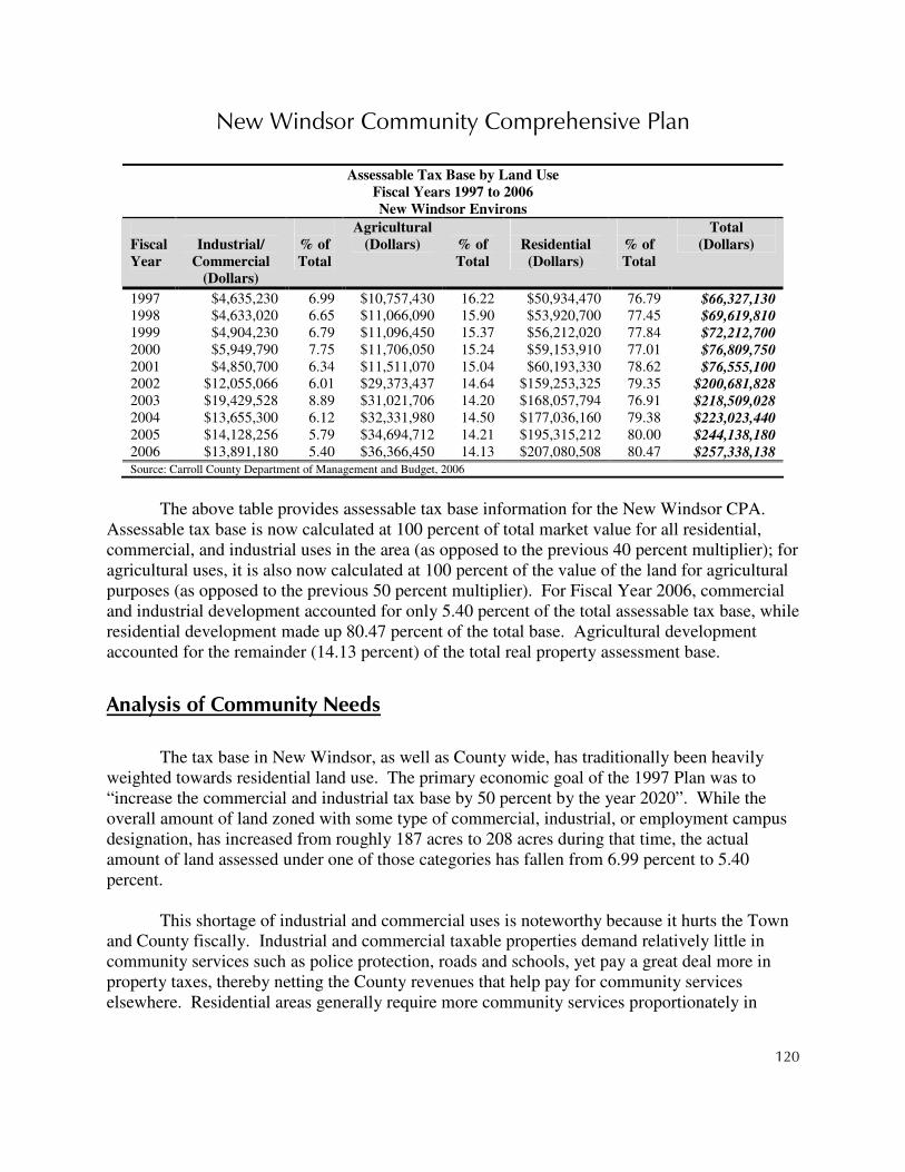
New Windsor Community Comprehensive Plan
120
The above table provides assessable tax base information for the New Windsor CPA.
Assessable tax base is now calculated at 100 percent of total market value for all residential, commercial, and industrial uses in the area (as opposed to the previous 40 percent multiplier); for agricultural uses, it is also now calculated at 100 percent of the value of the land for agricultural purposes (as opposed to the previous 50 percent multiplier). For Fiscal Year 2006, commercial and industrial development accounted for only 5.40 percent of the total assessable tax base, while residential development made up 80.47 percent of the total base. Agricultural development accounted for the remainder (14.13 percent) of the total real property assessment base.
Analysis of Community Needs
The tax base in New Windsor, as well as County wide, has traditionally been heavily weighted towards residential land use. The primary economic goal of the 1997 Plan was to “increase the commercial and industrial tax base by 50 percent by the year 2020”. While the overall amount of land zoned with some type of commercial, industrial, or employment campus designation, has increased from roughly 187 acres to 208 acres during that time, the actual amount of land assessed under one of those categories has fallen from 6.99 percent to 5.40 percent.
This shortage of industrial and commercial uses is noteworthy because it hurts the Town
and County fiscally. Industrial and commercial taxable properties demand relatively little in community services such as police protection, roads and schools, yet pay a great deal more in property taxes, thereby netting the County revenues that help pay for community services elsewhere. Residential areas generally require more community services proportionately in
Assessable Tax Base by Land Use
Fiscal Years 1997 to 2006
New Windsor Environs
Fiscal
Year
Industrial/
Commercial
(Dollars)
% of
Total
Agricultural
(Dollars)
% of
Total
Residential
(Dollars)
% of
Total
Total
(Dollars)
1997 $4,635,230 6.99 $10,757,430 16.22 $50,934,470 76.79 $66,327,130 1998 $4,633,020 6.65 $11,066,090 15.90 $53,920,700 77.45 $69,619,810 1999 $4,904,230 6.79 $11,096,450 15.37 $56,212,020 77.84 $72,212,700 2000 $5,949,790 7.75 $11,706,050 15.24 $59,153,910 77.01 $76,809,750 2001 $4,850,700 6.34 $11,511,070 15.04 $60,193,330 78.62 $76,555,100 2002 $12,055,066 6.01 $29,373,437 14.64 $159,253,325 79.35 $200,681,828 2003 $19,429,528 8.89 $31,021,706 14.20 $168,057,794 76.91 $218,509,028 2004 $13,655,300 6.12 $32,331,980 14.50 $177,036,160 79.38 $223,023,440 2005 $14,128,256 5.79 $34,694,712 14.21 $195,315,212 80.00 $244,138,180 2006 $13,891,180 5.40 $36,366,450 14.13 $207,080,508 80.47 $257,338,138 Source: Carroll County Department of Management and Budget, 2006
New Windsor Community Comprehensive Plan
121
relation to their property tax revenues. For industrial and commercial uses, the revenues exceeded the costs, but not by enough to offset the net loss incurred by serving a predominantly residential area. The lack of industrial and commercial uses results in pressure to raise property tax rates or limit services.
When zoning was originally put in place in many jurisdictions, many circumstances
affecting the selection of sites to be zoned for commercial and industrial uses were different. A higher emphasis and priority has been given to environmental considerations and constraints in the past couple of decades. As a result, factors which were not considered in the past provide constraints, often beneficial, through laws that protect citizens from the effects of harmful impacts on environmental resources. While these laws have improved the quality of life and the environment for the general public, they have also presented new challenges to existing and potential businesses.
Another factor affecting the appropriateness of sites for commercial and industrial use are
changes that have occurred through new trends in planning for communities. Current trends in communities indicate that citizens are seeking to maintain the existing community character through looking for improved quality of development, improved aesthetic appeal, and development design and amenities that reflect the traditional characteristics of our “old town” neighborhoods.
In the past, it was often assumed that public water and sewer service could be provided to
any site without difficulty. However, changes in federal and state laws as well as reductions in funds that are passed down to local governments have combined with other factors which influence the fiscal ability of many local jurisdictions to provide these services on their own. More and more, jurisdictions are providing these services through joint assistance from those who are creating the additional demand.
Among residents in New Windsor, the number of people employed in “Managerial and
Professional Specialty Occupations” grew by over 237 percent between 1990 and 2000. More residents of the area hold managerial and professional specialty jobs than any other category of job. This represents a large and growing professional labor force. However, few professional jobs are based in New Windsor or the environs. As a result, the area’s largest and fastest growing segment of workers must commute elsewhere in the County or in the region. Continuing this trend will require further investments in commuter roadway capacity or transit service. Commute times will increase as congestion increases. Commuters are also more likely to spend money outside of the New Windsor community, thereby supporting the tax bases and local economies of other communities.

New Windsor Community Comprehensive Plan
122
Recommended Actions
1 Continue to Coordinate Economic Development Efforts with the Carroll County Department of Economic Development
The Carroll County Department of Economic Development maintains staff that are experts in the area of economic development. These professionals can be very helpful to the Town in providing useful economic development and marketing assistance, directing appropriate potential commercial and industrial users to the available locations in the Town, and coordinating the efforts to recruit and retain businesses. As prospects investigate Carroll County as a potential area to locate new facilities, the majority of companies will contact the Department of Economic Development for assistance. A coordinated effort with this Department will ensure that the desired and appropriate prospects are directed toward the sites in New Windsor. The Department works to increase economic development opportunities in the county as a whole, including the towns; economic development in the incorporated areas also benefits the County at large, as well as providing coordination assistance on loans and financing.
2 Evaluate the Current and Vacant Supply of Industrial and Commercial Sites for Appropriateness and Feasibility
Many instances exist where the available undeveloped commercial and industrial sites are inappropriate for such uses. The Town needs to evaluate the existing, developed sites to determine if the assigned zoning is appropriate to the use that currently occupies the site or could occupy the site in the future. In addition, undeveloped sites should be evaluated to determine if they would indeed be attractive to potential new users. Existing sites should then be either reaffirmed or new sites identified (or a combination of both). New sites should be identified based on environmental constraints, the transportation network, market potential for the area, plans for extending public water and sewer services, available labor force, and community desires.
3 Evaluate Potential Areas to Market and Develop a Joint Marketing Plan with Carroll County Economic Development Department
Marketing certain areas for economic development involves not only identifying who will use or purchase certain goods and services once a business is here but also who we would be able to attract to the area to establish a new business. Some communities thrive on providing merely the basic traditional goods and services needed by the resident population. Others find that they need to identify or establish a certain “niche”. This niche emphasizes the advantages

New Windsor Community Comprehensive Plan
123
and amenities of the Town, capitalizes on the availability of other similar businesses, or builds on the proximity of another type of business that may be in need of support.
The Town should evaluate what types of businesses are most likely to locate in the area
and why. Once a market niche has been established, the Town should work with the County to develop a joint marketing strategy that will help to accomplish these goals.
4 Encourage Development of Attractive Business Areas
The Town wishes to preserve its small-town atmosphere, preserve its historic character, and retain the characteristics that make it unique. The design of traditional strip malls is inconsistent with those characteristics, not only in architectural design but in setbacks and parking requirements as well. Buildings should be set up close to the street, be pedestrian-oriented and friendly, and encourage parking to the rear of the building. These characteristics are not typically found in modern shopping center design, but that does not mean that shopping centers can not be made to fit in with the historic character of the Town. If a modern strip mall development is proposed anywhere in the town, the Town should be very adamant and steadfast in outlining requirements that would result in a shopping facility that did not look like a strip mall, was architecturally consistent with the historic atmosphere, and provided parking behind the facility that was well screened.
5 Promote Main Street Revitalization to Enhance Economic Viability of the Village Center
Main Street revitalization has a multitude of benefits, including increased attraction of visitors from outside of the Town and increased emphasis and interest on preserving the historic character. Visitors, whether from the local environs or from areas farther away, bring additional revenues to local merchants. Preserving the character of individual buildings and places within the Main Street area serves the dual purpose of increasing pride in history and community as well as improving the aesthetics of the streetscape. Main Street areas also are well-suited to attracting small businesses that can be the lifeblood of the local economy.
6 Identify Potential Additional Commercial Sites Close to the Village Center
If businesses are going to be directed to and concentrated in the village center area, additional sites will need to be identified to accommodate new businesses. While some vacant commercial spaces are available, an abundance of buildable land is not available fronting directly on Main or High Streets in what has been traditionally known as the downtown area. Potential new sites should be identified and should be located very close to the existing village center,

New Windsor Community Comprehensive Plan
124
preferably adjacent and adjoining to the village center and other mixed-use and commercial areas.
7 Evaluate and Build Upon the County Industrial Lands Study and Economic Development Element
The Department of Economic Development has developed and maintains responsibility for strategic marketing of the County for economic development purposes. Although the County and the Town will coordinate on issues that affect the Town and the Town will have input into the process, the Town may want to fully evaluate and consider additional measures it might take to enhance the attractiveness of New Windsor as a potential area for new industrial and commercial enterprises. Coordination with the Department of Economic Development will again provide the Town with the greatest opportunity for additional assistance.
8 Discourage Further Residential Development in Areas Designated for Future Industrial Use
The locations chosen for current and future industrial uses are carefully selected with very specific reasons and factors influencing these decisions. Several of the areas identified on the 2007 Land Use Designations map have already been compromised to some degree by small amounts of residential development. In these areas, additional steps will need to be taken by the industrial developers and users to minimize impacts to these homes. To make other parcels more attractive to potential industrial users, residential development in these areas should be discouraged and even prevented where possible.
9 Shift Priorities for Planned Water and Sewer Service Areas to Encourage Earlier Development of Industrial Areas
To be able to best respond quickly and efficiently when a potential industrial developer/user pursues a particular industrial site, public water and/or sewer service should be available or ready to be made available to further encourage the potential user to locate in New Windsor. This does not necessarily mean that the Town needs to invest in extending the water and sewer lines to the site prior to a potential user purchasing the site or submitting a development plan, although that would probably provide additional incentive. However, the Water and Sewer Master Plan and associated maps need to reflect the Town’s desire to be able to extend service at any time a new business is ready to locate there. The Water and Sewer Master Plan, as well as any projections or planned capital improvements to the water and/or sewer system, needs to also reflect the availability and possible reservation of capacity for this purpose. Projections of future system needs should take future industrial users into account.

New Windsor Community Comprehensive Plan
125
10 Consider Alternative Means to Finance Extension of Services to Tibbetts Industrial Area
If the Town invests in extending services to designated future industrial areas prior to actual demand, an incentive is provided to potential industries to come to New Windsor. Another incentive would be to ensure that adequate capacity of the water and sewer treatment systems will be readily available once needed. Each of these incentives may require costly improvements and investments. There are many other variables that impact this decision that the Town would need to consider, such as other parcels wanting to hook up to the system once the lines run in front of their property.
The Town may want to consider identifying potential sources of grant funds, such as
Community Development Block Grants for Economic Development (CDBG-ED) and other similar grants. In addition, the Town should seek assistance from the State, especially when the potential user would be significantly consistent with the State’s strategic economic development goals. The Town should consider working with the Department of Economic Development to solicit other funding sources from the State.
11 Adopt Legislation to Allow Town to Enter into Development Agreements with Potential Industrial Developers/Users
In 1995, the State of Maryland adopted legislation enabling local governments in Maryland to enter into “Development Rights and Responsibilities Agreements. This new law is now incorporated into '13.01 of Article 66B. “Development Rights and Responsibilities Agreements” (Development Agreements) are defined in Article 66B, '1.00(c) as “an agreement made between a governmental body of a jurisdiction and a person having a legal or equitable interest in real property for the purpose of establishing conditions under which development may proceed for a specified time”.
The adoption of local legislation by the Town enabling the Town to enter into
Development Agreements will provide the Town with additional tools necessary to move closer to accomplishing the goals and implementation strategies of the Town and its comprehensive plan. These Development Agreements could be especially useful in regard to the potential benefits involved with large-scale subdivisions. Plenty of time should be allotted, however, to identify the components that the Town would want included in the legislation and to proceed through the adoption process.

New Windsor Community Comprehensive Plan
126
12 Develop Bicycle/Pedestrian Pathway to Connect Tibbetts Industrial Area to the Village Center Allowing Multi-Modal Access to Industrial Areas by Employees
A bicycle/pedestrian pathway which provides linkage and access between the village center and the Tibbetts Industrial Area would provide a number of benefits. If new industrial users (which includes any use in the Employment Campus zone) provide additional jobs to the Town and the area, many of the labor force from which the business pulls may be people who live in or move to New Windsor. This pathway would reduce the number of automobile trips that might be necessary for those individuals who live within the Town. The pathway will eventually make a connection from the Tibbetts Lane terminus to the pathways that will be developed in the Employment Campus area on the north side of MD Route 31.
13 Consider Tax Abatement Program for Existing Commercial and Industrial Sites as Well as Homes Within the Main Street Area
Jurisdictions around the country are all competing for the same few industrial and business users that each year look at locations for new facilities. Therefore, it is important for the Town to be able to implement as many incentives as possible to give it even just that small edge over the next location.
One such incentive which has become especially important in recent history relates to tax
incentives. The Town should investigate employing a tax abatement program. This type of program would benefit a Main Street revitalization effort as well if applied within a designated area for revitalization in addition to other commercial and industrial areas. For these purposes, the program would allow residents to put additions on their homes, including rooms, decks and other home improvements up to a certain dollar amount (for ex. $25,000) without being assessed taxes on the improvements for a specified period of time (for ex. 5 years). Existing businesses could also benefit from a potential extra advantage of having no cap on the amount eligible for tax abatement and thereby encourage them to stay in the town center.
A tax abatement program encourages residents and businesses to make changes that
improve the Town and eventually results in higher tax revenues for the Town. Keeping accurate records will also be necessary to assure that the proper taxes are collected before the specified period of time ends.
14 Integrate Potential for “Mom and Pop” Convenience Uses into New Residential Neighborhoods to Promote a Sense of Community and Reduce Car Travel

New Windsor Community Comprehensive Plan
127
Individual neighborhoods should be part of the fabric of the community as a whole. For the most part, businesses should also be concentrated in the village center. Not only is it central to the majority of homes and services, it also draws the entire community to the village center. There are instances where it is also useful, however, to allow for new “mom and pop-type," small stores which provide basic staples such as groceries or services such as day care. To further minimize the reliance on automobiles and reduce the need for parking, the Town should consider allowing a limited amount of these types of stores, and possibly even require it in new developments. These small, family-run stores further help to increase community pride and character.
15 Incorporate Landscaping and Buffering Requirements into Industrial Areas to Protect Surrounding Uses and Community Character
Any type of industrial use, whether Light Industrial or Employment Campus, generates additional noise, traffic, and visual impacts to surrounding uses than were apparent prior to the development. As the Town has a unique and special small-town character, buffering between other uses, especially residential, will help to minimize those impacts and contribute to preserving community character. These buffers can provide a visual screen, help to absorb sound, and increase the aesthetic appeal, all of which can help to preserve property values as well.
Landscaping also provides a benefit to the businesses and their employees. Plants, open
spaces, and designated spots for employees may help to improve or maintain employee morale. They provide attractive places for employees to congregate, to take lunch breaks, and to increase pride in the company.
16 Encourage Potential Entertainment Rail Line Investors to Locate in the Area and Potentially Stop in Town
During its time of operation, the EnterTrainment Line attracted many visitors to the area. Many rumors have since circulated about potential new enterprises creating a similar operation in this area. How true these rumors are is unknown. However, the Town should take advantage of any opportunity to support and promote any potential to once again see this type of a service or entertainment available again on the Maryland Midland Rail Line. The Town may even want to go as far as to encourage someone considering such an operation to create a train station and/or other type of stop in New Windsor, rather than just passing through.

New Windsor Community Comprehensive Plan
128
17 Encourage the Use of Service Roads where Feasible for Access to MD 31 in Industrial Areas
MD Rt. 31 is currently operating at a high level of service because it is a limited-access highway. This level of service is a major benefit to the Town. It allows convenient, safe, and uninterrupted access to the Town for its residents. To maintain this high level of service, the Town should consider requiring service roads to be included in any new industrial development plan. This holds especially true in the Employment Campus district where the site will more than likely be subdivided to accommodate a number of enterprises. A service road will serve all users within the site but create only one access point onto the state highway. This will increase safety as the number of different access points will be minimized. It will also promote a better sense of oneness, interaction, and community among the users on the site.
The land designated for industrial use on the north side of MD Rt. 31 west of Wakefield
Valley Road would be a good candidate for requiring the service road to come out on Wakefield Valley Road rather than MD Rt. 31. This would further reduce potential traffic hazards.
Fiscal Implications
The recommendations contained in this plan may be policy-oriented or action-oriented, and their
implementation may be the responsibility of the County, other public agencies, private landowners and developers,
or a combination of these. This section is designed to identify the potential fiscal impacts to the County of each of
the recommendations. There could be “No Fiscal Impact,” meaning the County would not incur direct or
predictable expenses as a result of implementing the recommendation, an “Undetermined Impact,” meaning there
likely would be a cost associated with implementing the recommendation but that cost can not be determined at this
time for various reasons, or a “Fiscal Impact,” which likely would be incurred by the County if the recommendation
were implemented. For recommendations that have an identified fiscal impact, the cost of implementing that
recommendation is estimated to the best degree possible.
1 Continue to Coordinate Economic Development Efforts with the Carroll County Department of Economic Development
No Fiscal Impact
2 Evaluate the Current and Vacant Supply of Industrial and Commercial Sites for Appropriateness and Feasibility
No Fiscal Impact
New Windsor Community Comprehensive Plan
129
3 Evaluate Potential Areas to Market and Develop a Joint Marketing Plan with Carroll County Economic Development Department
No Fiscal Impact
4 Encourage Development of Attractive Business Areas
No Fiscal Impact
5 Promote Main Street Revitalization to Enhance Economic Viability of the Village Center
Undetermined Impact: While there likely would be a cost associated with the implementation of this recommendation, the project needs more development before a reasonable cost estimate can be determined
6 Identify Potential Additional Commercial Sites Close to the Village Center
No Fiscal Impact
7 Evaluate and Build Upon the County Industrial Lands Study and Economic Development Element
No Fiscal Impact
8 Discourage Further Residential Development in Areas Designated for Future Industrial Use
No Fiscal Impact
9 Shift Priorities for Planned Water and Sewer Service Areas to Encourage Earlier Development of Industrial Areas
No Fiscal Impact

New Windsor Community Comprehensive Plan
130
10 Consider Alternative Means to Finance Extension of Services to Tibbetts Industrial Area
Fiscal Note: The cost to extend public sewer to the Tibbetts Industrial Area is estimated to be $400,000 - $550,000. This includes approximately $100,000 for a pumping station and approximately 4,000 lineal feet of sewer main at approximately $75 per lineal foot. If the Town were to explore any grant opportunities to help finance this project, the total fiscal impact to the Town would vary greatly depending on the grantor and any other leveraging funds or contributions that might be used.
11 Adopt Legislation to Allow Town to Enter into Development Agreements with Potential Industrial Developers/Users
No Fiscal Impact
12 Develop Bicycle/Pedestrian Pathway to Connect Tibbetts Industrial Area to the Village Center Allowing Multi-Modal Access to Industrial Areas by Employees
Undetermined Impact: The cost to construct trails ranges from $100,000 per mile for a 6’ wide trail located on parkland to $500,000 per mile (including acquisition, construction and shoulder widening) for an 8-10’ wide trail located alongside a road. Because the trails proposed in this plan could be constructed in whole or in part by developers, the State Highway Administration, and/or the County, it is difficult to determine the direct fiscal impact that implementing this recommendation would have on the Town and/or County.
13 Consider Tax Abatement Program for Existing Commercial and Industrial Sites as Well as Homes Within the Main Street Area
Undetermined Impact: While there likely would be a cost associated with the implementation of this recommendation, the project needs more development before a reasonable cost estimate can be determined. Variables such as the amount of tax abatement and the time it was in effect could have varying impacts on the revenue that otherwise might accrue to the Town.

New Windsor Community Comprehensive Plan
131
14 Integrate Potential for “Mom and Pop” Convenience Uses into New Residential Neighborhoods to Promote a Sense of Community and Reduce Car Travel
No Fiscal Impact
15 Incorporate Landscaping and Buffering Requirements into Industrial Areas to Protect Surrounding Uses and Community Character
No Fiscal Impact
16 Encourage Potential Entertainment Rail Line Investors to Locate in the Area and Potentially Stop in Town
Undetermined Impact: While there likely would be a cost associated with the implementation of this recommendation, the project needs more development before a reasonable cost estimate can be determined. The fiscal impact might be influenced by various incentives or corollary programs that the Town might consider as a way of enticing investors to undertake this project.
17 Encourage the Use of Service Roads where Feasible for Access to MD 31 in Industrial Areas
No Fiscal Impact


New Windsor Community Comprehensive Plan
133
Chapter 11: Historic & Cultural Resources
Goals
• Increase outreach, awareness, and participation opportunities to enhance appreciation of New Windsor’s unique and rich heritage
• Protect and promote the historic character of New Windsor and its environs by improving the condition and stewardship of structures in its historic core
• Ensure that the best elements of community character and heritage are enhanced by current and future growth and redevelopment
Current Conditions
1 Historic Context
New Windsor is one of the smallest municipalities in Carroll County and is located in the western half of the county. Its history, development and architecture are rooted in the traditions of its Maryland piedmont location. In 1795, Isaac Atlee arrived in the area. In 1797, he laid out 28 lots, founding the town of New Windsor. Some time later, the town became known informally as Sulphur Springs, after the local springs that were thought to have medical value and later made the town a resort destination. The town didn’t see substantial growth until 1855, when increased residential interests in the town transformed New Windsor from a linear town into a town with a grid plan.
The stage coach and wagon roads which cut past the inn owned by Mr. Atlee on the
corner of Main and High Streets connected the area with Baltimore, Gettysburg, York and Philadelphia. New Windsor found itself the crossroads of much commercial activity and became a leading community for business. These roads also brought the Civil War armies of both the North and the South to New Windsor. In 1863, five thousand Union Calvary rode through the streets on their way to Gettysburg. The next summer, five hundred Confederate Cavalry raided the town and looted the stores of food, boots and clothing.
By 1862, New Windsor was the western end of the Western Maryland Railroad,
strengthening the town’s commercial base. This also led to new stores and hotels and the ability
New Windsor Community Comprehensive Plan
134
of the farmers to ship their produce to eastern areas of the state and nation. Religious services were first held in private buildings in New Windsor until the first
chapel was constructed in 1825. Andrew H. Baker took over an existing school in 1846 and named it New Windsor
Institution. The school operated with a 40-week term. When the existing structure became inadequate, Mr. Baker purchased land on which to erect a college building. When the new structure was completed, Calvert College took over the New Windsor Institution and was incorporated in 1856. Calvert College operated under the guidance of the Catholic Church. With the completion of the new building, the original building was no longer needed and was converted into the New Windsor Academy for Young Ladies.
Calvert College was sold to Dr. A.M. Jelly, who subsequently changed the name of the
college to New Windsor College. In 1912, the Church of the Brethren purchased the campus and relocated Blue Ridge College from Union Bridge to New Windsor. By 1944 the college was closed permanently. The site currently houses the New Windsor Brethren Service Center.
The first public school opened in the early 1870’s and was named New Windsor Public
School. New Windsor also had their first bank charted in 1860 and was titled First National Bank of New Windsor. Historians have noted that the town had quite a ‘building boom’ in the last few decades of the nineteenth century.
New Windsor boasts many distinctive architectural styles. The prominent styles include
the Pennsylvania Farm House, Queen Anne style, T-plan structures, bungalows and four-square. A variety of out buildings still exist in the town, which are mainly located in the alley ways. Although New Windsor architectural styles date back to the late 18th century, there is a strong presence of elegant Victorian homes that reflect the affluence that arrived with the railroad beginning in 1862. Many of the industrial buildings that once stood along the railroad tracks in town, along with the depot, have been demolished.
Virtually untouched by growth from World War II until the end of the 20th century, the
town has been “rediscovered” as a haven of old-time peace and tranquility. But despite the new popularity, old New Windsor remains a quaint small town set in the beautiful rolling hills and farmland of rural western Carroll County.
2 Inventory of Identified Historic Structures, Sites, and Districts
A number of inventoried historic structures, sites and districts exist in New Windsor and the surrounding area. Included is the New Windsor National Register Historic District, which encompasses most of the historic core of the town. The inventoried sites and district boundaries

New Windsor Community Comprehensive Plan
135
are shown on the Historic and Cultural Resources map and are listed in the table below.
Inventory of Historic Structures, Sites and Districts
New Windsor Community Planning Area
2006
ID Number Site ID Number Site
CARR 17 Old Main CARR 274 311 High Street
CARR 18 Sulphur Springs CARR 275 114 Church Street
CARR 148 A. Hibberd/ Buckey-Bixler Farm CARR 551 Bixler House
CARR 157 Bixler Barn CARR 877 Elhannon/The Englar Farm
CARR 169 New Windsor Presbyterian Church CARR 937 G. Hibberd House
CARR 175 Pipe Creek Church CARR 938 W. Hibberd House
CARR 176 Pipe Creek House CARR 939 Hibberd House, site
CARR 202 Avalon CARR 940 Windsor Castle
CARR 203 Sunny Brook Farm CARR 941 J. Frank Getty Farm
CARR 271 Englar House CARR 1402 Sensinig-Ecker House
CARR 272 312 High Street CARR 1407 Sullivan-Waesche House
CARR 273 Joseph Stouffer House CARR 1492 New Windsor Historic District
3 Description of Historic Preservation Resources
Many tools exist for the property owner interested in historic building or landscape preservation. Organizations and programs dedicated to providing technical and financial assistance for historic preservation exist at both the state and local level, in the public and private sector. Organizations and programs that can assist property owners in Carroll County are listed below.
Historic Preservation Resources
Resource
Type
Name Description
Organizations National Park Service Chief administrator of the National Historic Preservation Act of 1966 in concert with the states. Keeper of the National Register of Historic Places and lead agency for Section 106 review. Oversees National Historic Landmark program. Provides some funding to state preservation offices for operating expenses, some of which is passed on to local governments through the Certified Local Government program.
National Trust for
Historic Preservation National, private non-profit organization. Sponsors the National Main Street Center and a Heritage Tourism program, provides loan and grant programs for historic preservation efforts, and co-sponsors the Barn Again! program to encourage the preservation of barns.
Advisory Council on
Historic Preservation Independent Federal agency that advises the President and Congress on historic preservation matters, particularly Federal or Federally-assisted projects that impact National Register properties.

New Windsor Community Comprehensive Plan
136
Historic Preservation Resources
Resource
Type
Name Description
Maryland Historical Trust
The Division of Historical and Cultural Programs in the Maryland State Department of Planning acts as the State Historic Preservation Office by conducting historic and archaeological resource surveys and is the central repository for these records for all counties in the state; nominating properties to the National Register; carrying out Section 106 reviews administering Federal and State preservation grants; reviewing Federal and State tax incentive projects; and assisting with preservation planning statewide.
Maryland
Environmental Trust Organization created by the Maryland General Assembly to conserve and protect the state’s open space and natural environment. Core program is the conservation easement program. Also administers the Local Land Trust Assistance Program, the “Keep Maryland Beautiful” program, and Rural Historic Village Protection Program.
Preservation Maryland Private, non-profit preservation organization that works statewide to preserve historic buildings,
districts, and archaeological sites. Provides grants and loans for preservation projects. Maryland Historical
Society Private, non-profit organization dedicated to collecting, preserving, and interpreting the state’s history. Houses a library and research center as well as permanent and rotating exhibits.
Historical Society of
Carroll County Private, non-profit organization dedicated to preserving and interpreting the county’s past.
New Windsor
Heritage Committee Private, non-profit organization dedicated to preserving and interpreting New Windsor’s past. They maintain a large collection of photographs, documents and other artifacts as well as a recently opened museum.
Programs National Register of Historic Places
A listing of properties and districts significant in American history and culture. Significance is determined by a set of eligibility criteria. Nominations are made through the completion of a standard form submitted to MHT then NPS. Listing is voluntary and non-regulatory, and enables property owners to apply for Federal and State tax benefits, loans and grants for certain preservation work.
National Historic
Landmarks Program administered by the National Park Service that designates structures of national historical significance. Landmarks are subject to Section 106 Review and may be preserved through Congressional legislation if threatened. Landmarks are automatically entered on the National Register as well.
Local Historic
Districts Three local historic districts exist in Carroll County: Uniontown, Sykesville and Westminster. The Carroll County Preservation Commission has been authorized by the County government to establish and enforce design guidelines for Uniontown and any future local historic districts in the County so that the historical and architectural qualities of the district are preserved. Municipal historic district commissions were created to monitor the Sykesville and Westminster districts. Standards apply to alterations or demolitions that affect the exterior of the property.
Section 106 Review Section of the National Historic Preservation Act that requires Federal agencies to take into
consideration the impact of Federally funded or permitted projects on historic properties and allows the Advisory Council on Historic Preservation the opportunity to review the projects as well.
Federal Rehabilitation
Tax Credit Allows owners of income-producing property to receive a Federal investment tax credit for income taxes equal to 20% of the costs of rehabilitation if it is certified as complying with the Secretary of the Interior’s Standards for Rehabilitation. Administered by MHT and NPS.
Maryland
Rehabilitation Tax Credit
Provides investment tax credits for income taxes equal to 20% of capital costs for the rehabilitation of owner-occupied or income-producing properties. Work must conform to the Secretary of the Interior’s Standards for Rehabilitation and must be certified by MHT, which administers the program.

New Windsor Community Comprehensive Plan
137
Historic Preservation Resources
Resource
Type
Name Description
Easements A mechanism by which limitations are placed on development potential or structural alterations through a legal document that remains with the property regardless of ownership. Easements can be held by Federal, state, and local government agencies and private organizations that are tax-exempt, charitable, educational non-profits. The value of the donated easement is tax deductible and some tax benefits also my be realized through a reduced property value due to development restrictions.
Transfer of
Development Rights
A mechanism by which the right to develop a property is separated from the sending historic site and exchanged at an agreed market value to allow the development to occur at another location. Legal agreements document the transfer of the right from the original historic location and permanently protect it from alterations, development or demolition.
Rural Historic Village
Protection Program A program of the Maryland Environmental Trust. Seeks to protect the historic context of rural villages through the preservation of surrounding landscapes. Utilizes a combination of conservation easement, historic preservation easements, state agricultural easements, and county agricultural districts.
Certified Local
Government Provides competitive grants for historic sites survey, preservation planning, and heritage education to local governments that have legislation in place to designate and protect historic properties. Certified Local Governments also must have a qualified historic preservation review commission, must create and update an inventory of historic properties, and must allow public participation in local preservation programs.
Maryland Heritage
Preservation and Tourism Areas Program
Provides matching grants and loans and tax credits to historic or contributing non-historic properties within a Certified Heritage Area. Certification is obtained through MHT and the Maryland Heritage Areas Authority. Maryland’s “Heart of the Civil War Heritage Area” includes parts of Carroll County.
Rural Legacy Land preservation program administered by the Maryland Department of Natural Resources that
seeks to preserve areas rich in agricultural, natural, and cultural resources that will promote resource-based economies, protect green belts and greenways, and maintain the fabric of rural life.
Main Street Program Downtown revitalization program administered by the Maryland Department of Housing and Community Development. Competitively selected communities receive assistance in improving the economy, appearance and image of their traditional downtown business districts. The program is based upon the National Trust for Historic Preservation's Main Street Approach, which applies a four-point approach to revitalization: organization, promotion, design, and economic restructuring.
4 Heritage Tourism
The term heritage tourism refers to tourist activity that is oriented around the visitation of historic and cultural attractions, natural resources, and local dining and lodging establishments that impart a unique, regional experience not duplicated anywhere else. Heritage tourists are in search of the “real” and “authentic” qualities of a place. The heritage tourism market is a lucrative one to pursue since studies have shown that tourists who fit the heritage tourist profile often are more highly educated, older, and wealthier and, as a result, tend to spend more per trip than the average tourist. However, to attract the heritage tourist, a locality must be able to offer them the type of unique and authentic experience they seek. Carroll County is fortunate to have many of the requisite qualities for heritage tourism – quaint and attractive downtowns that have been preserved to a large extent, an array of unique local dining and shopping opportunities, a

New Windsor Community Comprehensive Plan
138
calendar of events that reflect the region, and beautiful rural scenery. But in order to capitalize upon the potential that exists, a conscious effort must be put forth to retain and attract unique businesses and cultural facilities, preserve the historic fabric of the towns, and protect the rural countryside and way of life.
One major boost to local efforts is the recent designation of Maryland’s “Heart of the
Civil War Heritage Area.” The “Heart of the Civil War Heritage Area” (HCWHA), along with its management plan, was certified by the Maryland Heritage Areas Authority in July 2006 as the eleventh heritage area in the state certified through Maryland’s Heritage Preservation and Tourism Areas Program. The heritage area includes significant portions of Carroll, Frederick, and Washington counties that contain Civil War battlefields and other sites related to the conflict. In Carroll County, these sites primarily relate to supply efforts and troop movements through the area prior to and after the Battle of Gettysburg. The County’s portion of the heritage area includes the corridors (defined as 500 feet from the centerline) of most of the major roadways. All of the incorporated municipalities contain at least one of these routes and, therefore, lie partially within the heritage area.
Certification enables Carroll County businesses and organizations to use State grants,
loans, and tax incentives to undertake projects that support the heritage area’s goals and capitalize on the area’s significant Civil War-related history. Additionally, Target Investment Zones (TIZs) have been identified as part of this process. TIZs are areas towards which substantial amounts of funding are to be directed as a result of their having concentrations of heritage resources and visitor services. In Carroll County, three activated and/or potential TIZs have been identified: Taneytown, Westminster, and Sykesville. Properties within activated TIZs are eligible for additional grants and loans for capital projects and economic development projects, as well as state income tax credits for the rehabilitation of certified heritage structures. Other jurisdictions may be deemed eligible if they choose to apply for TIZ certification.
Nearly all of the jurisdictions in the county have completed the needed documentation
that will make them eligible to apply for funding or other program designations. On September 6, 2006, the Mayor and Council of New Windsor passed a resolution amending the comprehensive plan to incorporate those portions of the Heart of the Civil War Heritage Area Management Plan that apply to the Town of New Windsor. That plan is incorporated by reference into this update of the comprehensive plan as well.
A similar national effort, underway beginning in the fall of 2006, may designate portions
of Carroll County as part of the “Journey Through Hallowed Ground National Heritage Area”. In its initial proposal this effort will tie broader themes including historical, cultural, social and political events that are core to our national identity into a geographically connected corridor. While the effort is in its relatively early stages, it will undoubtedly offer similar and perhaps more significant benefits to areas included within its jurisdiction.

New Windsor Community Comprehensive Plan
139
Analysis of Community Needs
The lifeblood of any community is the enthusiastic support and participation of its members. New Windsor’s population has had a long standing appreciation of its past, whether it be a part of an active group whose mission is to share New Windsor’s history or those many residents who are drawn to the quality of life in the area communicated by its quaint charm. By engaging all portions of the community as partners and stewards of this rich heritage to rehabilitate the historic structures and sites, not only will the physical presence of the town be improved but the sense of pride in place will be continually improved as well.
New Windsor is in the very fortunate position of having had a well documented and
comprehensive survey of its historic resources that ultimately led to its inclusion on the National Register of Historic Places in 1997. With this vital tool in place, much of the core of the town, as well as those areas that were part of the historic growth of the town spanning from the late 18th through the early 20th centuries, are eligible to apply for various funding programs to support the physical rehabilitation as well as the economic revitalization that the community wishes to see. Program resources may include tax credits, heritage area funding, community development grants, homeowner loan programs, and more.
Quality of life and sense of place are communicated by all of the elements of a
community. The impression created by not only residential development but by landscaping, signs, commercial and retail buildings as well as industrial development all combine to paint an ever-changing image of a community. The most effective way to protect and preserve community character is to develop a “toolkit” of many strategies that will ensure that the best elements of the community are understood and reinforced through the form and type of new growth.
The community desires to retain a small town feel by monitoring development design to
ensure it fits into the existing character of the community. Town officials are interested in developing design guidelines and/or a pattern book. This pattern book would serve as a guide for town officials, policy makers, and developers to the shared and agreed upon feel and character of the community.
New Windsor Community Comprehensive Plan
140
Recommended Actions
1 Encourage Local Groups to Develop Programs and Activities to Promote Awareness of the Town’s History, the Importance of Preservation, and Ways Residents Can Participate
The New Windsor Heritage Committee has worked diligently to promote and preserve the heritage of the Town. The Heritage Committee, although not affiliated with the Town government, has approximately 15 members, some Town residents and some not. The committee is concerned with activities that promote the heritage and history of the town as well as promote preservation of that history and the things which demonstrate that history. An on-going project, begun in cooperation with the Historical Society of Carroll County with funding from the Carroll Community Foundation, has been an archeological dig at the site of the Town’s Sulphur Spring. This effort has garnered volunteers and visitors of all ages from throughout the County and has successfully raised awareness and appreciation of the role of the spring and the springhouse on the site. Recently, in a cooperative effort with New Windsor State Bank, they have achieved a long term goal to open a museum to display their collections as well as make information and resources about the Town’s past more easily accessible.
Historically, the Committee has organized a New Windsor house tour every other year to
raise money for the Committee’s functions and to showcase the town’s architectural history. In 1994, a sesquicentennial celebration was organized to celebrate the 150th anniversary of the incorporation of the Town. Among many other activities that were part of this celebration, a walking tour was developed and remains part of the menu of activities for residents and tourists to the area. A program was created permitting residents to purchase a plaque identifying the year the house was built for display on the front of the house. The Heritage Committee, in addition to other interested partners and stakeholders, should continue to identify and promote activities which encourage town residents to take an active role in preserving the history and historical character of the town.
2 Review and Revise New Windsor Sign Code to Ensure that Signs Improve the Aesthetics of the Town as Well as Complement the Image of the Town
Attractively designed street signs tell a great deal about a community’s self-esteem, expressing a sense of neighborhood pride. They symbolize a community’s economic vitality, ethnic diversity, and culture. The visual impression that one carries of a place is largely shaped by sign design.

New Windsor Community Comprehensive Plan
141
The size, style, and materials of signage affect the appearance of the entire streetscape. A consistent aesthetic theme for the signs will help to create a more attractive environment. The following guidelines are recommended for design of these signs.
SIZE - The size of the sign should be determined by the scale of the building to which it
belongs as well as the scale of the surrounding buildings and streetscape. In addition to respecting the architectural character, the size of the sign and the wording should be determined by the viewer’s location and speed.
LETTERING - The lettering should be proportional and balanced, providing enough
surrounding space on the sign for it to be quickly readable. Lettering styles should complement the style of the building and should be easy to read.
ILLUMINATION - The surface of the sign should be evenly lit and not excessively bright.
Rather than internally illuminated signs, external direct lighting should be provided using appropriate spotlights or another type of light source shining directly on the sign. It is recommended that businesses do install lights with the signs to provide better lighting for customers when light is low or there is poor visibility.
COLOR - Colors should be chosen which complement the general tone of the building and
the surrounding streetscape. When more than one sign is used for one building, the colors on each sign should be coordinated with each other.
MATERIALS - Materials and textures should be selected which fit into the architectural
character of the building and streetscape. Materials that are durable and of high quality would ensure that the sign continues to look attractive over time.
RELATIONSHIP TO BUILDING AND STREETSCAPE - Signs should conform to the architectural
style of the streetscape. Rather than competing with each other, the signs should be designed to be consistent, compatible, and complement each other. The signs should not overwhelm the site or the streetscape.
LANDSCAPING - Freestanding signs should be integrated into the surrounding landscape
through the use of trees, shrubs, and flowers. The landscaping style and materials should be chosen to look attractive year-round.
STYLE - For those businesses with projecting signs hanging from storefronts, a double-
sided sign may be hung from a wrought-iron bracket. Wall signs may also be used above the storefront area. Awning, canopy, and window (painted) signs are encouraged as long as they do not serve to further clutter the building with too many signs. Roof signs are highly discouraged.

New Windsor Community Comprehensive Plan
142
The courts have upheld attempts by communities to prescribe sign control regulations as a means of maintaining, protecting, and improving their physical appearance in order to promote the general welfare. The courts have generally rejected the argument that sign ordinances improperly restrict the right of business owners to advertise.
3 Encourage the redevelopment of tax-credit eligible historic properties in Town to improve the overall condition of New Windsor’s income-producing and residential properties.
With the listing of the town’s historic district on the National Register of Historic Places in 1997, every contributing building in the district became eligible through both state and federal programs to receive investment tax credits against income taxes. For income-producing properties, including residential rentals, professional offices, and commercial uses, the federal tax credit of 20% of the cost of renovations may be combined with the state tax credit of 20% to help promote better renovation and stewardship of the structure. The state program also enables the portion of the tax credit that exceeds income taxes due to be refunded directly to the applicant. Residential properties in the district are eligible to use the state tax credit program to offset costs involved with renovations. A recent addition to the Maryland Historical Trust grant and loan program permits homeowners applying for tax credits to apply for special low interest loans to support exterior rehabilitation work.
4 Consider developing a municipal Main Street effort
With a track record of more than 20 years of successful community rebuilding, the National Main Street Center’s four-part program (developed by the National Trust for Historic Preservation) provides a very workable model for jurisdictions to begin to model their community revitalization efforts. Experience from the program has shown that a gradual, incremental approach is the most sustainable. As New Windsor and its adjacent communities continue to grow, market opportunities for appropriately-scaled businesses and commercial redevelopment in the Village Center, Neighborhood Business, Light Industrial, Commercial and related zones will grow as well. As the town begins to fulfill its residential density goals found in this and previous comprehensive plans, even further market opportunities will be created. Once the individual elements of this four-part strategy are analyzed and ranked by priority, the Town can begin efforts to recruit targeted businesses or commercial partners. To support this effort the Town may wish to develop some additional benefits such as a façade improvement grant program, an assessment freeze or abatement of town property taxes for a specified period of time as an additional support to attract these Main Street partners. Funding to support such efforts may be found through Maryland Department of Housing and Community Development’s Neighborhood Revitalization programs or through programs associated with heritage area grant funding.
New Windsor Community Comprehensive Plan
143
These efforts may be further supported with the physical streetscape enhancements sought from the State Highway Administration if and when funding becomes available.
5 Create Design Guidelines and/or a Pattern Book to Help Retain Small Town Character
New Windsor has a rich architectural heritage that has created a collection of neighborhoods, remarkable for its uniqueness in character. The architectural style of the houses varies from neighborhood to neighborhood, especially in the traditional neighborhoods located in the “Village Center” section of Town. In recent years, the distinctly different quality of the traditional architectural styles has been affected by the mass production of houses that seem the same wherever they are located. Also, homeowners often have a difficult time finding builders, architects or materials and components that are in keeping with the period and detailing of their original house.
Developing design guidelines or a pattern book would assist the Town Officials,
developers/builders, homeowners, and communities as they repair, rebuild and expand their houses and neighborhoods. In collaboration, the Town of New Windsor and the County should publish a Pattern Book for New Windsor that identifies the various styles found in different neighborhoods and then illustrates key components such as the shape of windows and doors, roof pitches, eave details and types of porches that are appropriate for the character of the community. Design guidelines and/or a pattern book would ensure that remaining developable areas within or adjacent to Town, as well as parcels that may see redevelopment or infill construction, are compatible with the desired traditional patterns and building types found in the Town.
From remodeling a front door or redevelopment of existing structures, to building a new
house or a whole new housing development, the pattern book will provide examples of the appropriate design and use of materials to ensure a result that is compatible with character of the community.
6 Review Town codes for elements that may contradict efforts to preserve, adapt and re-use existing historic structures in Town.
Zoning and other ordinances can have the unintended consequence of allowing or even encouraging changes to standing structures, landscapes, streetscapes or other features that contradict efforts to retain those elements of town that communicate its heritage, culture and history. From time to time, even with the most carefully considered regulations, it is only after actual implementation that these contradictions of purposes become apparent. In an effort to continue to improve the town, pressure for change and redevelopment can cause a short term project to override long term policies, goals and visions. To prevent those circumstances, a

New Windsor Community Comprehensive Plan
144
system of regular review to ensure that the code is continuing to meet and anticipate the balance of needs for the community is advised. This process also can involve the community into a more active and regular dialogue about their vision and preferences for their community.
7 Seek to ensure that development at the perimeter of the New Windsor CPA maintains consistency with community character and reinforces a distinct town edge or boundary.
As growth occurs at the edges of New Windsor and its community planning area, it becomes increasingly important to consider how these gateways to town create that all important “first impression”. While areas outside the village center are often appropriate for non-residential development, it is critical that this type of development maintains compatibility with and connection to the heart of New Windsor. Landscape controls, design expectations or guidelines, and similar review processes and ordinances, can be used to manage not only where needed development happens but how it looks and how it blends with the existing community. Tandem to this effort is establishing and maintaining a definable edge to Town as it expands. A variety of tools including easements, annexation plans and limitations of infrastructure and geographic boundaries may all be utilized to determine the ultimate boundaries of the Town’s growth and ensure its separation from adjoining communities.
Fiscal Implications
The recommendations contained in this plan may be policy-oriented or action-oriented, and their
implementation may be the responsibility of the County, other public agencies, private landowners and developers,
or a combination of these. This section is designed to identify the potential fiscal impacts to the County of each of
the recommendations. There could be “No Fiscal Impact,” meaning the County would not incur direct or
predictable expenses as a result of implementing the recommendation, an “Undetermined Impact,” meaning there
likely would be a cost associated with implementing the recommendation but that cost can not be determined at this
time for various reasons, or a “Fiscal Impact,” which likely would be incurred by the County if the recommendation
were implemented. For recommendations that have an identified fiscal impact, the cost of implementing that
recommendation is estimated to the best degree possible.
1 Encourage Local Groups to Develop Programs and Activities to Promote Awareness of the Town’s History, the Importance of Preservation, and Ways Residents Can Participate
Undetermined Impact: While there likely would be a cost associated with the implementation of this recommendation, the project needs more development before a reasonable cost estimate can be determined

New Windsor Community Comprehensive Plan
145
2 Review and Revise New Windsor Sign Code to Ensure that Signs Improve the Aesthetics of the Town as Well as Complement the Image of the Town
No Fiscal Impact
3 Encourage the redevelopment of tax-credit eligible historic properties in Town to improve the overall condition of New Windsor’s income-producing and residential properties.
No Fiscal Impact
4 Consider developing a municipal Main Street effort
Undetermined Impact: The fiscal impacts of undertaking this project primarily relate to the salary that would need to be paid to a part- or full-time Main Street manager. This could range anywhere from $30,000 - $60,000, depending on hours and benefits.
5 Create Design Guidelines and/or a Pattern Book to Help Retain Small Town Character
Undetermined Impact: The Town could choose to undertake this project on their own, or they could hire a historic preservation consultant to develop design guidelines or a pattern book. The cost to hire a consultant to do this work could cost in the range of $15,000 - $30,000, depending on the extent of services provided.
6 Review Town codes for elements that may contradict efforts to preserve, adapt and re-use existing historic structures in Town
No Fiscal Impact
7 Seek to ensure that development at the perimeter of the New Windsor CPA maintains consistency with community character and reinforces a distinct town edge or boundary
No Fiscal Impact

New Windsor Community Comprehensive Plan
147
Chapter 12: Community Involvement
Goals
• Increase citizen awareness of, and participation in, planning and other related community issues and processes
• Increase citizen awareness of, and participation in, implementing action strategies developed as a result of planning efforts and other related community initiatives
Citizen participation is an important component in the process of developing
comprehensive and facility plans and in the decision-making process of approving plans for development. The citizens of the New Windsor Community Planning Area have various opportunities to participate in and influence the Town’s and the County’s decision-making relating to future development in their community. Public participation includes activities such as voting for elected officials, running for public office, attending public meetings and hearings conducted by elected officials or appointed boards or commissions, attending public workshops or committee meetings, and participating as members of committees or appointed boards or commissions. The Carroll County Board of Commissioners appoints qualified citizens to numerous boards and commissions, including: Planning and Zoning Commission, Board of Zoning Appeals, Environmental Affairs Advisory Board, Agricultural Preservation Advisory Board, Board Of License Commissioners, Historic Preservation Commission, Economic Development Commission, Industrial Development Authority, Children’s Council, Commission on Aging, Recreation and Parks Board, and Board of Social Services.
Current Conditions
Several formal opportunities are available to the citizens of the New Windsor Community Planning Area to voice their concerns and provide input on issues that are important to them. Citizens are strongly encouraged to participate in the review and revision of both the Carroll County Comprehensive Plan and the New Windsor Community Comprehensive Plan.

New Windsor Community Comprehensive Plan
148
1 Government Structure
The Town of New Windsor is governed by a Charter. The Town Charter allows town residents the opportunity to vote for the town council and mayor. The town council and mayor are responsible for operating the municipality by adopting necessary legislation and undertaking the general administration of Town business. They serve for a four-year term. All qualified residents have the opportunity to register with the Town and vote for the town council and mayor.
The Board of Carroll County Commissioners is the local legislative body for the New
Windsor Community Planning Area that is outside of the Town limits. The members of the Board are elected at large for four-year terms. The County Commissioners serve as both an executive and legislative body, deriving their powers from the state legislature through enabling legislation. Since Carroll County is neither a code nor charter county, many of the laws that govern the County must be adopted by the Maryland Legislature.
In terms of State representation, the New Windsor election district is located in
Legislative District 4B, which is represented by one Senator and one Delegate in the Maryland Legislature in Annapolis. At the Federal level, the planning area is located in the Sixth Congressional District, which is represented by one member of the U.S. House of Representatives in Washington, D.C. Two Senators in the U.S. Senate also represent the State as a whole.
2 Current Citizen Participation Opportunities
A Town Planning Commission & Zoning Administrator
The Town Planning Commission is a seven-member commission created with powers and duties as set out in Article 66B, Zoning and Planning, of the Annotated Code of Maryland. Commission members are appointed by the Mayor and Council for terms of five years each, one member is a council member to serve in an ex officio capacity. The Commission meets on the fourth Tuesday of every month in the Town Hall. The duty of the Zoning Administrator is to process all zoning applications in accordance with town zoning codes. The Zoning Administrator may also make determinations of some zoning waivers in accordance with town code.
B Carroll County Planning and Zoning Commission

New Windsor Community Comprehensive Plan
149
The seven-member (plus alternate) Planning and Zoning Commission is an appointed body responsible for such planning-related activities as developing and approving comprehensive plans, approving subdivision and site development plans, and recommending a Capital Improvement Program to the County Commissioners. The Planning Commission also recommends to the County Commissioners amendments to planning-related regulations and ordinances such as the subdivision regulations and zoning ordinance (ordinance text and zoning map). The Planning Commission holds public meetings twice monthly to consider planning-related projects and issues. Citizens are welcome to attend; meetings are held on the third Tuesday of each month and in the evening on the fourth Monday of each month. The Planning Commission is required to hold public hearings to receive input on comprehensive plan elements, updates, or amendments. The Planning Commission considers the comments received before approving the plan and submitting it to the County Commissioners for adoption.
C The Planning Process
Article 66B of the Annotated Code of Maryland mandates that the Planning Commission develop and approve a comprehensive plan and recommend it to the local legislative body for adoption. Community meetings and workshops are held to encourage citizen input to help ensure that the vision and goals of the plan reflect the desires of the community.
D Town Board of Zoning Appeals
The Board of Zoning Appeals consists of three members appointed by the mayor for terms of three years each. In general the Board hears and decides on issues pertaining to special exceptions, and variances. The powers of the Board are defined in the Code of the Town of New Windsor.
E Carroll County Board of Zoning Appeals
The Board of Zoning Appeals (BZA) is a quasi-judicial body comprised of three members. The Board is empowered to hear and decide on requests for conditional uses and authorize appeals for variances to the zoning ordinance. The BZA may also hear and rule on appeals to orders, requirements, decisions, or determinations that are made by an administrative officer in the enforcement of Article 66B or any ordinance adopted under the article. These cases may involve, for example, appeals to actions of the planning commission. The BZA conducts public hearings to address all cases that are filed for its review and action. Public hearing notices are published in local newspapers, signs are posted on properties under review, and notices of the public hearings are mailed to adjoining property owners. The public hearings and notification of them provide an important opportunity for citizen input to these cases.

New Windsor Community Comprehensive Plan
150
F Carroll County Subdivision Advisory Committee
Citizens have an opportunity for input in the early stages of the review and approval process involved with the development of property. The Subdivision Advisory Committee (SAC) is comprised of County and State agencies that review and comment on subdivision and site development plans. SAC meets monthly to publicly review all development plans submitted to the County and to present its recommendations and requirements to the owner/developer of the property and the developer’s engineer. When a property owner is contemplating the improvement or subdivision of his or her property, notices of the SAC meeting are mailed to adjoining property owners and signs are posted on the property informing the public of the scheduled SAC meeting. Citizens are invited to attend the SAC meeting to voice their concerns on the proposed development at this early design stage.
3 Citizen Information Sources
A Media
Residents in the New Windsor area have a variety of sources of information to keep informed of local events and activities. The Town publishes a bi-monthly newsletter that contains a variety of local meeting notices, community events and articles relevant to area citizens. The Carroll County Times, the Carroll County edition of the Baltimore Examiner, and the Carroll County edition of The Baltimore Sun are general-circulation daily newspapers that focus on news in Carroll County, in addition to providing regional, state, national, and world news. Landmark Community Newspapers of Maryland, Inc., publisher of the Carroll County Times, also circulates two free monthly publications, Carroll Families and Carroll Seniors. These periodicals contain feature stories and County activities aimed at families and senior citizens, respectively. The Gazette Newspapers of Maryland are another publisher of weekly community papers; they also distribute their Mt. Airy Gazette in the New Windsor area.
Numerous television and radio stations broadcast regional news and information that may
include Carroll County. WTTR (1470 AM), located in Westminster, focuses on Carroll County news and events. In addition to its standard offering of network and cable stations, the county’s cable television service provider, Comcast, operates Cablevision Channel 3, a commercial local origination channel that covers local news and events, and Channel 24 (CCG24), a new channel devoted to Carroll County Government that broadcasts public meetings, events, and other programs related to local government. Additionally, Comcast broadcasts Carroll Community Television Channel 19, Carroll Community College Television Channel 18, and Carroll Educational Television Channel 21 (sponsored by Carroll County Public Schools), noncommercial local access channels that include information on local news and events as part of their scheduled programming.

New Windsor Community Comprehensive Plan
151
Carroll County Government posts its legal ads in the Carroll County Times and provides
press releases to the media regarding current events and issues. Additionally, notices of upcoming meetings are provided for inclusion in the community news and events sections of local papers. The County also uses WTTR, Cablevision Channel 3 and Channel 24, and Carroll Community Television Channel 19 to convey public information.
B Internet
The Internet is a growing resource of information for citizens. One website that contains information oriented to Carroll County is located at http://ccgov.carr.org. This site contains extensive information on the County, County government, municipalities located in the County, the public library system, schools, services and organizations, and businesses. Also available from this web site are either live web-streaming broadcasts of County meetings or archived video of County meetings or hearings for many boards and commissions. This resource is available for meetings dating back to July, 2006.
On-line information related to updates of the community comprehensive plans can be
found on the county website’s page for the Department of Planning within the Bureau of Comprehensive Planning section.
The Town of New Windsor maintains a website with a variety of useful facts including
meeting schedules, contact information, rosters of various committees and boards, and needed public information such as the Town’s charter and codes. This website is linked to the Carroll County website or may be reached directly via http://www.newindsormd.us.
Analysis of Community Needs
Numerous opportunities already exist for the community to be involved in government-related issues. Opportunities for improvement, however, do exist. When community surveys were conducted for the 1997 plan, many of the residents indicated that they receive information regarding public decisions, meetings and community participation opportunities from newspapers and mailed flyers. However, few people indicated they actually attended any pubic meetings held by County or Town officials. Public meeting agendas are posted and often printed in local newspapers, but these meetings are not broadcast on cable television for public viewing on a regular basis.
Although these conditions may lead to a lack of citizen involvement, the reality is that
most people will not participate in meetings or other public participation opportunities unless they feel directly and significantly impacted. This apathy often leaves the community unaware

New Windsor Community Comprehensive Plan
152
of the plans for the community or the issues within the community which need to be addressed. The effect is that a very small number of people often influence decisions meant to address the good of a much larger community.
Although a need always exists for local governments to find additional ways to solicit
input from a greater number of citizens, there also is an element of social and political apathy that must be addressed as well. One major impediment to overcoming the relative public apathy associated with the planning process is the length of time taken to produce the plans. Momentum built up in the initial phase of the public participation quickly is lost when the plans go into the “drafting” stage, where shifting priorities for staff and lengthy writing requirements can create a lag time of at least six months, sometimes much more.
Recommended Actions
1 Survey the community periodically to ensure that the desires of the residents are still being accomplished and to identify new desires
The success of a comprehensive planning effort is not just measured when the plan is adopted. It is an ongoing challenge to ensure that the plan continues to embody the desires of the community and is being implemented as recommended. Because old residents and businesses are continually leaving and new ones taking their place, the population served by the plan is always changing. Periodic surveys of the population about their goals and concerns for the environs will inform planners and others who are implementing the plan as to how well the plan is upholding or changing to meet the needs of the community.
2 Continue to provide updates on projects, events, and the implementation of specific plan recommendations through a community newsletter or website
Part of making a comprehensive plan a “living document” is to keep its relevance in the forefront of people’s minds. While this is more easily accomplished with those whose job it is to implement the plan, providing the general citizenry with updates on the progress of implementation will help them to understand the importance of the document and how it affects their everyday lives, and should provide some encouragement to them to participate in future planning efforts as well.
In addition to updates on the comprehensive plan process, it is important that all web-
based data is maintained so to be current and effective. Once community members become familiar that current data is easily available, they may also become confident to relying on the data provided.
New Windsor Community Comprehensive Plan
153
Ultimately, the users of this resource may become more informed and more active citizens thanks to the schedule flexibility afforded by electronic participation.
3 Form citizen committees to implement appropriate strategies from the comprehensive plan as well as other community projects
One of the best ways to keep citizens involved in the planning process is to vest them by giving them some measure of oversight or responsibility for implementing plans. Citizen committees that are charged with the implementation of specific items contained in the plan could serve as an opportunity for people to become involved in the process and perform the critical function of putting the plan’s recommendations into effect. Additionally, through this process, new issues or potential solutions may come to light. Citizens should also be enlisted in town-organized and directed efforts to research and develop solutions to address these current issues to the maximum extent possible.
4 Find ways in which the plan update process can be shortened to maintain interest and momentum
One of the greatest challenges posed by the planning process is finding ways to keep people’s interest and momentum throughout an effort that, by its very nature, is methodical and time-consuming. Great lengths are taken to reach out to as many people as possible and much time is spent gathering the information that will validate the plan’s recommendations. More frequent plan updates could reduce the amount of time needed to do this work, and concentrated points of public input could be programmed into the process so that momentum is not lost. Other creative ways to achieve these objectives should be sought as well.
Fiscal Implications
The recommendations contained in this plan may be policy-oriented or action-oriented, and their
implementation may be the responsibility of the County, other public agencies, private landowners and developers,
or a combination of these. This section is designed to identify the potential fiscal impacts to the County of each of
the recommendations. There could be “No Fiscal Impact,” meaning the County would not incur direct or
predictable expenses as a result of implementing the recommendation, an “Undetermined Impact,” meaning there
likely would be a cost associated with implementing the recommendation but that cost can not be determined at this
time for various reasons, or a “Fiscal Impact,” which likely would be incurred by the County if the recommendation
were implemented. For recommendations that have an identified fiscal impact, the cost of implementing that
recommendation is estimated to the best degree possible.

New Windsor Community Comprehensive Plan
154
1 Survey the community periodically to ensure that the desires of the residents are still being accomplished and to identify new desires
Undetermined Impact: While there likely would be a cost associated with the implementation of this recommendation, the project needs more development before a reasonable cost estimate can be determined. Fiscal impacts would vary depending upon the method used to survey community residents and could be minimized, if not eliminated, if integrated into existing forms of communication such as the Town newsletter or the Town’s website.
2 Continue to provide updates on projects, events, and the implementation of specific plan recommendations through a community newsletter or website
Undetermined Impact: While there likely would be a cost associated with the implementation of this recommendation, the project needs more development before a reasonable cost estimate can be determined. Fiscal impacts would vary depending upon the method used to survey community residents and could be minimized, if not eliminated, if integrated into existing forms of communication such as the Town newsletter or the Town’s website.
3 Form citizen committees to implement appropriate strategies from the comprehensive plan as well as other community projects
No Fiscal Impact
4 Find ways in which the plan update process can be shortened to maintain interest and momentum
No Fiscal Impact

New Windsor Community Comprehensive Plan
155
Chapter 13: Interjurisdictional Coordination & Communication
Goal
• Improve communication and coordination between the towns, county, and state and to increase partnering with other government bodies on local community projects Under the Planning Act, local comprehensive plans must include recommendations for
improving planning and development processes to encourage economic expansion and to direct future growth to appropriate areas. Such development and economic growth often have interjurisdictional impacts on transportation infrastructure, the environment, and other areas of concern. For this reason, it is necessary for planning, growth strategies, and policies to promote and encourage cooperation among adjacent jurisdictions.
No one will dispute that interjurisdictional coordination is important and valuable.
However, when real-world issues are confronted by jurisdictions with conflicting agendas, ideals often fade, and agreement can be difficult to achieve. It will be impossible to achieve the intent of the Planning Act without immediate and effective interjurisdictional coordination. It is necessary to identify potential conflicts, address them as an integral part of comprehensive plan preparation, and include provisions in the plan for continuing coordination and cooperation. As jurisdictions collaborate on issues of mutual interest in their respective comprehensive plans, they generally become more aware of one another’s needs and priorities. This contributes to their ability to better anticipate potential problems.
The most important benefit of timely interjurisdictional coordination is that it enables the
affected jurisdictions to identify and resolve issues at the earliest possible stage when they are usually easiest to address and manage.
Current Conditions
Carroll County Government has been practicing interjurisdictional coordination and communication with the Town of New Windsor, as well as the other municipalities in Carroll County, for many years. These activities have produced numerous benefits and provided mutual assistance between jurisdictions.

New Windsor Community Comprehensive Plan
156
1 Town/County Agreement
The primary instrument for interjurisdictional coordination and communication between the Town of New Windsor and Carroll County is the formal document generally known as the Town/County Agreement. Annually signed by both jurisdictions, the agreement enumerates services provided by the County to the Town and provides for the coordination of planning and other governmental functions. Both jurisdictions participate in coordinated planning efforts and joint review of subdivision and site plans, development proposals, master (or comprehensive) plans or revisions, draft amendments to development-related ordinances and regulations, rezoning proposals, and annexation petitions. Development plans and other proposals are exchanged between the Town and County for informational purposes and to provide staff and elected officials the opportunity to comment. County projects or proposals relating to land located within one mile of the town are submitted to the Town for review and comment. Certain County agencies also review plans for conformance with Town regulations and ordinances such as stormwater management and forest conservation. Town and County staffs also attend the other’s Planning and Zoning Commission meetings to keep apprised of planning activities in each jurisdiction. As specified in the agreement, the County also provides certain services to the Town, such as general planning and zoning services, and data processing services for tax and utility billing.
The Town/County Agreement with the Town of New Windsor creates a cooperative
relationship between the two jurisdictions that fosters open communication and the exchange of information regarding planning and development matters. As a result, a “joint planning approach” is cultivated that promotes consistency within the overall New Windsor environs. In addition, many planning-related issues can be resolved at the staff level early in the process.
2 Joint Comprehensive Plan
Traditionally, the County and its municipalities prepare, approve, and adopt comprehensive plans jointly. For each plan, a Community Planning Area (CPA) is delineated that includes the entire municipality and an area surrounding the municipality that forms the unincorporated portion of the overall community. In preparing the comprehensive plan jointly, the various elements of the plan (e.g., goals, land use, transportation, public water and sewer service, etc.) are developed so that they are compatible throughout the community planning area. The joint comprehensive planning process involves extensive participation by the County and Town planning staffs. The New Windsor Planning Commission approves the portion of the Community Planning Area located within the Town’s corporate limits, and the Town Mayor and Town Council adopt the same portion of the plan. Correspondingly, the Carroll County Planning Commission approves and the County Commissioners adopt the unincorporated portion of the comprehensive plan. The current New Windsor Community Planning Area Comprehensive Plan

New Windsor Community Comprehensive Plan
157
was jointly adopted in 1997.
3 County Provides Staff Assistance
As mentioned above, a provision of the Town/County agreement involves County staff assistance to the towns on planning-related issues. A County planning staff member acts as a liaison to the Town’s planning office and planning commission. This arrangement aids in the prevention of planning and development conflicts and the development of compatible plans, goals, and regulations.
4 Mutual Referral of Development Proposals and Other Planning Activities
As provided for in the Town/County Agreement, the County makes its development review staff available to the Town to review and comment on development plans located within the Town. Following submittal of a development plan by the Town, County staff reviews and provides comments on storm water management, grading and sediment control, forest conservation, water resources, and other technical issues. Development review staff checks development plans for conformance with applicable regulations and for practicality of design. Planning staff reviews for conformance with the comprehensive plan, major street plan, water and sewerage master plan, historic resources, and general design. The County provides inspections for sediment control, storm water management, and forest conservation for the Town. The County also collects the bonds for forest conservation.
In addition to the reciprocal review of development plans, both jurisdictions also notify
each other of planning-related activities within their respective jurisdictions (within one mile of New Windsor for County activities). These activities include proposals for rezonings, annexations, plan amendments, and amendments to development-related ordinances and regulations.
In addition to the mutual review of development plans between New Windsor and the
County, proposals for development projects located within the county are also submitted to various State agencies for review and comment, and in some cases, approval. The State Highway Administration and Health Department are the agencies most frequently involved.
5 Council of Governments
In the past, the County Commissioners met on a quarterly basis with the Mayors from all of the towns in an effort to foster interjurisdictional coordination and cooperation. These meetings have been replaced by a Council of Governments (COG). Included are representatives

New Windsor Community Comprehensive Plan
158
from all eight municipalities, the Finksburg Planning Area Council, the Freedom Area Citizen's Council, the Maryland Municipal League, State and County representatives, the Board of Education, and the Health Department. By state law, voting members are limited to member governments, towns and the County, but everyone is invited to participate. The group exercises no legislative power, however. The purpose of the COG is to bring these diverse groups together to discuss issues of mutual interest, which are decided upon by the members, thereby facilitating information sharing and promoting a new level of cooperation/coordination.
6 Policy Regarding Annexation
The Town/County Agreement between the Town of New Windsor and Carroll County contains a policy statement and procedure concerning annexation areas. The agreement states that future growth and development in the New Windsor area that is planned to be served by public facilities should take place within the Town’s corporate limits. This is because both jurisdictions recognize that the public health, safety, and welfare will be best served through mutual cooperation and the coordination of responsibility for those areas that logically should become part of the Town of New Windsor. This joint cooperation will serve to ensure the continuity of municipal services and maintain the effectiveness of planning functions.
To achieve this objective, the Town and County have mutually agreed upon and
designated a future corporate limit line (Growth Area Boundary). This line serves to guide and anticipate where municipal services (public water and sewer, fire hydrants, police, street lighting, garbage and recyclables collection, etc.) may logically be needed. When land located within the future corporate limits is proposed for development, the County, following input from the Town, will determine whether the land can be annexed into the Town prior to or following development.
7 Membership and Participation in Maryland Association of Counties
The Maryland Association of Counties, Inc.’s (MACo) members are the elected governing officials of Maryland’s twenty-three counties and Baltimore City. MACo’s members work in committees to determine policy and positions on executive and legislative proposals. Members also attend annual conferences to obtain timely information concerning the issues that face county government. The Association is an important communication link. It serves as a clearinghouse for information pertaining to county government in Maryland.
The Legislative Committee meets weekly during the Maryland General Assembly
Session, reviewing proposed legislation impacting county government. The Legislative Committee and MACo staff sponsor various legislative initiatives affecting local government and disseminate information to the Association’s membership on all bills relating to county

New Windsor Community Comprehensive Plan
159
government. In addition to its efforts during the legislative session, MACo works throughout the year advocating county interests on issues and specific bills.
MACo is an important voice for county government in Maryland. The Association
represents the viewpoint of the state’s twenty-four subdivisions before the Governor, the General Assembly, administrative officials of the executive branch, and federal decision-makers. MACo strives to ensure that issues important to the counties are heard whenever programs or problems affecting local government are discussed at the state or federal level.
8 Membership and Participation in Baltimore Metropolitan Council
Carroll County is a member jurisdiction of the Baltimore Regional Transportation Board (BRTB). The BRTB, which is the metropolitan planning organization (MPO) for the Baltimore region, is an organization of the region’s elected officials that serves as a forum for identifying regional interests and developing collaborative strategies, plans, and programs that will improve the quality of life and economic vitality throughout the region. The Council’s Board of Directors consists of the Mayor of Baltimore, the elected executives of Anne Arundel, Baltimore, Carroll, Harford, and Howard Counties, and the City of Annapolis. The Baltimore Metropolitan Council (BMC) provides staff support to the BRTB.
The BRTB’s mission is to provide a forum for cooperative regional planning; provide an
opportunity to discuss differences among its members in attaining regional goals, collect, analyze, and disseminate regional data; cooperate and communicate with neighboring regions; ensure cost-effective delivery of services through cooperation with all levels of government; and participate with citizens and others interested in solving regional problems.
To achieve these objectives, the Board provides the following activities or programs:
long-range regional transportation planning; development of demographic, economic, and geographic data; cooperative purchasing to provide cost-saving opportunities to member jurisdictions; assistance in environmental programs such as air and water quality; computerized mapping services; and acting as a regional information center.
Through its involvement on the Baltimore Regional Transportation Board, the County is
able to participate in regional planning efforts and ensure that the other member jurisdictions take into consideration issues that are important to Carroll County, including the towns. The County can also gain important information and services provided by the Council and share more fully in the benefits that accrue to the Baltimore region as a whole.

New Windsor Community Comprehensive Plan
160
Analysis of Community Needs
Carroll County has a long history of close interjurisdictional coordination between the County and its municipalities. Joint planning has been conducted for decades, voluntarily setting a precedent that only now is being mandated in other jurisdictions across the state. In New Windsor, the annual renewal of the Town/County agreement, cooperation on development issues, and monthly attendance at meetings by a liaison planner from the county staff all point to ongoing coordination and a close relationship between the Town and County.
The most notable improvement that could be made with respect to interjurisdictional
coordination lies with the annexation process. In the past, the Town has undertaken several annexations that have not followed the required process and have necessitated retroactive actions by the County. The recent annexation legislation passed in 2006 may address some of these inconsistencies by more clearly defining the annexation process.
Recommended Actions
1 Continue the close level of coordination between the Town and County regarding development issues
Through the use of the Town/County agreement and joint planning efforts, the Town and County have been able to work together to address ways to implement the vision and goals of the comprehensive plan. Whether it is working to approve a subdivision plan within established regulations, planning for long-range infrastructure improvements, or draft and adopting a zoning map, the close relationship enjoyed by the Town and County has benefited both jurisdictions and helped both achieve the vision and goals expressed by their citizenry.
2 Ensure that the required annexation process is followed
The Town and County should work together to ensure that the proper channels of action are followed to initiate and complete the annexation process. This is not an issue isolated to the Town of New Windsor; several annexations have occurred in the past in which towns undertook the, held public hearings, and passed annexation resolutions without notification to the County. This necessitated a retroactive action in which the annexation was acted upon on after the fact. The new annexation requirements adopted by the State legislature in 2006 in HB 1141 requires, among other things, that the State Department of Planning be given the opportunity to comment on annexation petitions and that, after October 1, 2009, all annexations be in compliance with the adopted municipal growth element of the comprehensive plan. These new requirements should

New Windsor Community Comprehensive Plan
161
help address the issues of coordination and communication with respect to annexations that have occurred in the past.
Fiscal Implications
The recommendations contained in this plan may be policy-oriented or action-oriented, and their
implementation may be the responsibility of the County, other public agencies, private landowners and developers,
or a combination of these. This section is designed to identify the potential fiscal impacts to the County of each of
the recommendations. There could be “No Fiscal Impact,” meaning the County would not incur direct or
predictable expenses as a result of implementing the recommendation, an “Undetermined Impact,” meaning there
likely would be a cost associated with implementing the recommendation but that cost can not be determined at this
time for various reasons, or a “Fiscal Impact,” which likely would be incurred by the County if the recommendation
were implemented. For recommendations that have an identified fiscal impact, the cost of implementing that
recommendation is estimated to the best degree possible.
1 Continue the close level of coordination between the Town and County regarding development issues
No Fiscal Impact
2 Ensure that the required annexation process is followed
No Fiscal Impact

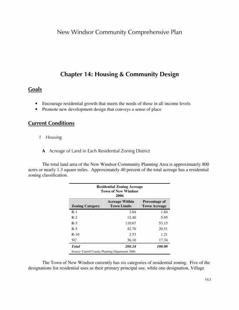
New Windsor Community Comprehensive Plan
163
Chapter 14: Housing & Community Design
Goals
• Encourage residential growth that meets the needs of those in all income levels
• Promote new development design that conveys a sense of place
Current Conditions
1 Housing
A Acreage of Land in Each Residential Zoning District
The total land area of the New Windsor Community Planning Area is approximately 800 acres or nearly 1.3 square miles. Approximately 40 percent of the total acreage has a residential zoning classification.
Residential Zoning Acreage
Town of New Windsor
2006
Zoning Category
Acreage Within
Town Limits
Percentage of
Town Acreage
R-1 3.84 1.84
R-2 12.40 5.95
R-3 110.67 53.15
R-5 42.70 20.51
R-10 2.53 1.21
VC 36.10 17.34
Total 208.24 100.00
Source: Carroll County Planning Department 2006
The Town of New Windsor currently has six categories of residential zoning. Five of the
designations list residential uses as their primary principal use, while one designation, Village

New Windsor Community Comprehensive Plan
164
Center (VC), is a mixed use designation with residential being an allowed use. The R-1 zone has a maximum density of 1 unit per acre. The R-2 zone has a maximum density of 2 units per acre; R-3 has a maximum density of 3 units per acre; R-5 has a maximum density of 5 units per acre and R-10 has a maximum density of 10 units per acre.
Carroll County currently has five categories of residential zoning but only four of those
categories within the New Windsor Community Planning Area. Conservation requires a maximum lot yield of 1 buildable lot per 3 acres, generally clustered into 2-3 acre lots. Suburban Residential, or R-10,000, requires an approximate minimum lot size of one-quarter acre. Medium-Density Residential, or R-20,000, requires a minimum lot size roughly equal to one-half acre. Low-Density Residential, or R-40,000, requires a minimum lot size of 1 acre. The following table presents a breakdown of the amount of land within each residential zoning category for the entire Community Planning Area.
Residential Zoning Acreage
New Windsor CPA Outside of Town Limits
2006
Zoning Category
Acreage Within
CPA
Percentage of
CPA Acreage
Conservation 43.79 28.40
R-10,000 39.69 25.74
R-20,000 20.99 13.61
R-40,000 49.72 32.25
Total 154.19 100.00
Source: Carroll County Planning Department 2006
B Percentage of Different Housing Types
Almost 83 percent of all units in the Town of New Windsor in 2000 were single-family detached and attached (townhouse) units, with multi-family making up the bulk of the remaining 17.5 percent. During the period of 1990-2000, the total number of units in the Town increased by 187 (or 56%), with single-family detached and attached being the only housing type to see a proportional increase during that time. The following table shows the percentage of housing types within the study area for 1990 and 2000.

New Windsor Community Comprehensive Plan
165
Housing Type
Town of New Windsor
1990 and 2000
1990 2000
Housing Type Units % Units %
Percent
Change (%)
Single-Family Detached/Attached 210 63.3 428 82.5 103.8
Multi-Family 116 34.9 90 17.3 -22.4
Mobile Home/Trailer 0 0.0 1 0.2 ------
Other 6 1.8 0 0.0 -100.0
Total Units 332 100.0 519 100.0 56.32
Source: U.S. Census
C Renters vs. Owners
Of the residential structures within the Town of New Windsor, approximately 72.8 percent were owner-occupied. Just over 20 percent were renter-occupied while roughly 6.5 percent were vacant. The following table exhibits the occupancy status by type of dwelling within the study area in 2000.
Occupancy by Type of Dwelling
Town of New Windsor
2000
Structure
Owner
Occupied
Renter
Occupied
Vacant
Total*
SF (Detached) 339 32 18 389
SF (Attached) 31 8 0 39
2 Units 7 30 1 38
3-4 Units 0 3 2 5
5-9 Units 0 17 1 18
10+ Units 0 17 12 29
Mobile Home 1 0 0 1
Total 378 107 34 519
Source: U.S. Census
Census data from 1990 and 2000 show that the number of owner-occupied dwellings had
increased within the town over that time period, while the number of rented dwellings remained unchanged. The number of vacant dwellings dropped during the decade. As a portion of the total dwellings available, owner-occupied dwellings increased significantly between 1990 and 2000, due to the completion of two subdivisions. The following table shows the shift between 1990 and 2000.

New Windsor Community Comprehensive Plan
166
Occupancy by Type of Tenant
Town of New Windsor
1990 & 2000
1990 2000
Occupant Units % Units %
Percent
Change (%)
Owner 184 55.4 378 72.8 105.4
Renter 107 32.2 107 20.6 0.0
Vacant 41 12.4 34 6.6 -17.1
Total 291 100.0 519 100.0 78.35
Source: U.S. Census
As of 2000, the largest percentage of owner-occupied residential units (45.7%) fell within the $100,000 - $149,999 range, with an overall median housing value of $146,200. The following table presents specified owner-occupied residence values in 2000.
Specified Owner-Occupied Value
Town of New Windsor
2000
Value # of Units % of Units
Less than $50,000 2 0.6
$50,000 - $99,999 31 8.6
$100,000 - $149,999 165 45.7
$150,000 - $199,999 132 36.6
$200,000 - $299,999 27 7.5
$300,000 or more 4 1.1
Total 361 100.0
Median Housing Value $146,200
Source: U.S. Census
Cash rent values were also tabulated for renter-occupied residences in the Town of New Windsor based on 2000 Census returns. The majority of the units (53.3%) fell into the $500 - $749 range, with a median contract rent of $595. The following table exhibits the monthly cash rent values for specified renter-occupied units in 2000.

New Windsor Community Comprehensive Plan
167
Specific Renter-Occupied
Residential (Cash Rent)
Town of New Windsor
2000
Rent # of
Units
% of
Units
Less than $300 2 1.9 $300 - $499 27 25.2 $500 - $749 57 53.3 $750 - $999 12 11.2 $1,000 or more 9 8.4
Total 107 100.0 Median Rent $595 Source: U.S. Census
D Current Affordable Housing Programs
There are currently several housing assistance programs available within the County. They are as follows: Section 8 Rental Assistance, Rental Assistance Program, Rural Development, and the Interfaith Self Help Program. Carroll County Section 8 Program exists to assure decent, safe, and sanitary housing communities of their choice, to eligible families, based on the family’s income, assets and deductions.
Roughly 25 households within the New Windsor area are currently receiving some sort of
housing assistance. The Rental Assistance Program offers temporary rental assistance for low-income households. Rural Development assistance can be used by low-income families to purchase, refinance, and rehabilitate a dwelling with no down payment. Interfaith Housing helps working families build their own affordable homes, working with their neighbors and with the assistance of a construction supervisor.
E General Assessment of Condition of Current Housing
A majority of the existing structures in the Town of New Windsor are of a relatively young age. Roughly 52.6 percent of the housing stock was built after 1960. The most rapid period of growth occurred between 1990 and 2000 with 45.1 percent of the housing stock being constructed within that time period. The following table indicates the age of the Town of New Windsor’s housing stock in 2000.

New Windsor Community Comprehensive Plan
168
Age of Housing
Town of New Windsor
2000
Year Built # of
Units
% of
Units
1990-March 2000 234 45.1
1980-1989 14 2.7
1970-1979 13 2.5
1960-1969 12 2.3
1940-1959 58 11.2
1939 or earlier 188 36.2
Total 519 100.0
Source: U.S. Census
Analysis of Community Needs
The median owner-occupied housing value for the Town area has risen from $108,900 in 1990 to $146,200 in 2000. The median cost per month for renter-occupied housing has risen from $423 in 1990 to $595 in 2000. During that same time period, median household income has risen from $33,167 in 1990 to $51,799 in 2000. So the general cost of housing and rental units relative to the average annual income in the study area has remained fairly stable. However, the overall availability of rental housing has declined as a part of the total housing stock from 32.2 percent to 20.6 percent during that same time period. When coupled with the rapid increase in the price of new single-family housing units throughout the region, low-income families and young families are finding it inherently more difficult to find affordable housing in the immediate area.
Affordable housing opportunities are increasingly limited. Within the Town, most of the
new housing constructed recently has been larger single-family housing. Additionally, the land within the CPA that is undeveloped, is generally designated for more of the same. Other than using a single family detached home as two units, the agriculture, conservation, and low-density residential zoning that exists outside of the Town limits does not permit multi-family housing and townhome style development. Higher-density housing, other than assisted living or continuing care facilities, is generally limited to municipalities and CPA’s that provide the applicable zoning and are served by public water and sewerage facilities.
Recent subdivisions have also lacked accessibility to the town and overall continuity with
the surrounding built environment. Preserving the character of the town may be unattainable if current large lot, disconnected development patterns persist in the future on the remaining developable lands within the Community Planning Area. Automobile-oriented developments

New Windsor Community Comprehensive Plan
169
tend to promote isolation and/or often fail to provide a sense of place or community feel.
Recommended Actions
1 Pattern new development after desirable qualities of established built environment
Smart Growth and the concept of traditional neighborhood design cannot be realized unless Town and County agencies become committed to implementing their defining characteristics. These include providing pedestrian links, creating through streets, adding streetscaping, and supporting the natural extension of development whenever possible. The center of Town should be maintained as the heart of the area, but at the same time as new properties develop, small pockets of civic and commercial activity around which neighborhoods are based could be established. This will begin to create a pattern of development that echoes the traditional pattern and provides opportunities for creating pedestrian-friendly environments and a sense of place.
In order to help preserve the rural atmosphere of the area, the Town is encouraged to
work with the County in creating design guidelines for both subdivisions and site plans, consider adopting cluster provisions, and provide the option for Planned Unit Development (PUD).
2 Allow for diversity of housing types
An increased number of housing options for residents has historically been offered in the growth areas of the County. This is due to the availability of services that allow development at greater densities and lower net cost. In order to provide for the housing needs of all Carroll County residents, providing a diverse housing stock must be a priority.
3 Maintain densities within the Community Planning Area that support the creation of compact communities
Fully utilizing the land and density that is available within the CPA will more effectively accommodate the future growth in the county. Support for the development of compact communities results in the reduction of infrastructure costs and a logical, predictable pattern of growth. To this end, the Town should consider amending its R3 zone to allow a maximum density of 3.5 units per acre. This will enable the undeveloped land to qualify for PFA designation.
New Windsor Community Comprehensive Plan
170
4 Amend subdivision/site plan regulations and the zoning ordinance to require architectural renderings with plans
Requiring the submission of architectural renderings during preliminary plan review will allow the Planning Commission to consider the aesthetic qualities of development and call for growth to fit in with and improve the appearance of the community. This will promote the development of the built environment that instills pride in the members of the community and is consistent with the architectural heritage of Carroll County.
Fiscal Implications
The recommendations contained in this plan may be policy-oriented or action-oriented, and their
implementation may be the responsibility of the County, other public agencies, private landowners and developers,
or a combination of these. This section is designed to identify the potential fiscal impacts to the County of each of
the recommendations. There could be “No Fiscal Impact,” meaning the County would not incur direct or
predictable expenses as a result of implementing the recommendation, an “Undetermined Impact,” meaning there
likely would be a cost associated with implementing the recommendation but that cost can not be determined at this
time for various reasons, or a “Fiscal Impact,” which likely would be incurred by the County if the recommendation
were implemented. For recommendations that have an identified fiscal impact, the cost of implementing that
recommendation is estimated to the best degree possible.
1 Pattern new development after desirable qualities of established built environment
No Fiscal Impact
2 Allow for diversity of housing types
No Fiscal Impact
3 Maintain densities within the Community Planning Area that support the creation of compact communities
No Fiscal Impact
4 Amend subdivision/site plan regulations and the zoning ordinance to require architectural renderings with plans
No Fiscal Impact

New Windsor Community Comprehensive Plan
171
Chapter 15: 2007 Land Use Designations The 2007 New Windsor Community Comprehensive Plan essentially validates the 1997
New Windsor Community Planning Area Comprehensive Plan, with some modifications to reflect issues that have emerged over the past ten years. While the plan contains a host of recommendations related to a variety of topics, one of the most important expressions of the plan’s vision, goals, and recommendations is the 2007 Land Use Designation map. In conjunction with the other maps and text recommendations contained in the plan, the 2007 Land Use Designations map will guide the future use of land both within Town and in the Community Planning Area. The desired land use in any given area is the starting point for nearly all other land development-related actions, including zoning changes, the provision of services, planning for anticipated population growth, and the creation of parks and other public facilities, among other things. For this reason, the plan culminates in the 2007 Land Use Designations map.
The following table summarizes the type, acreage, and percentage of land use
designations shown on the map.
Land Use Designations Acreage
2007 New Windsor CPA (Amended)
Land Use Category
Existing
Town
Percentage
of Town
Existing
County
Percentage
of County
Conservation Public Use 91.3 20.7 50.5 13.1 Employment Campus 28.4 6.4 42.0 10.9 Light Industrial* 75.6 17.1 72.2 18.8 Neighborhood Business 4.3 1.0 10.0 2.6 R1 3.0 0.7 68.7 17.9 R10 2.5 0.6 2.1 0.5 R2 13.2 3.0 70.0 18.2 R3 110.7 25.1 28.9 7.5 R5 42.7 9.7 10.0 2.6 Village Center 42.3 9.6 0.0 0.0
Total Acres 414.1 100.0 384.4 100.0 * An estimated 27.2 acres and 30.1 acres of Employment Campus Overlay are designated on areas of Light Industrial within the Town and County portions of the growth area, respectively
Source: Carroll County Planning Department, 2010 Revised to reflect removal of Lease properties from growth area (2010 Amendment)