Embed Size (px)
Citation preview

2 CASE STUDYBuckholt and Cranham Woods
Location: Buckholt and Cranham Woods
Water course: Painswick Stream
Sub-catchment: Painswick Valley, Stroud Frome
OwnershipThe woodland and stream are privately owned by two separate owners, with the stream forming the ownership boundary for part of the work site. On one side, the woodland is leased and managed by Natural England; the other is maintained privately.
AccessNearly all of the works are visible from public footpaths.
About the projectThe aim of this work was to slow down the fl ow of fl ood peaks into the valley and improve the habitat of the Painswick stream. Sixteen large woody debris (LWD) leaky dams constructed from tree trunks and branches were installed to create a partial blockage of the stream. In low fl ows, water can pass freely under the structure, but at high fl ows after very heavy rain, some water will be attenuated behind the leaky dam, slowing it down.
How it was achievedStructures within the NNR were specifi cally designed to be as natural as possible and to mimic natural tree fall. They are mostly composed of a single beech or ash tree trunk with branches left intact. Trees that had already fallen naturally were pulled into the channel and any cutting necessary was undertaken in-situ. There was no machine access on the NNR so structures were created using a hand winch and crow bar. These structures took three days to build and four volunteers from the AONB Cotswold Wardens worked for a day to help with this work. These structures were not pinned in place.
Leaky dams upstream of the NNR were created using several pre-felled alder tree trunks. These structures could be described as semi-natural. Machine access was possible on this part of the site so a tractor and winch were used to move the timbers. These fi ve structures are pinned in place using 1.2m reinforcing steel bars. The structures took two days to build and fi x, and six volunteers from the AONB Cotswold Wardens worked for a day to help.
A second technique used within Cranham woods was the diversion of surface drainage pathways. Originally, water draining from fi elds above the spring line fl owed down an eroded gully and into a well-formed ditch and footpath. The ditch had previously been well maintained so it carried silt and nutrient-laden water effi ciently and directly to the source of the Painswick Stream. As part of the project, the eroded gully was fi lled with brash and smaller pieces of timber and the fl ow route was blocked to keep the water out of the ditch and off the footpath. This diverted the water over the woodland fl oor to allow signifi cantly higher rates of infi ltration. The drainage diversion and fi lled gulley took one day to complete. A small 3 tonne excavator was used to block the original ditch and to create an initial fl ow route on the opposite side of the valley, while fi ve volunteers worked to fi ll the erosion gulley with brash.
The contract for all the work was awarded to the landowners’ own forestry contractor. The Rural SuDS project offi cer worked as a supervising labourer to oversee construction design and location. All timber was donated to the project by the landowners.
ConsentsThe works described above required three main types of consent:
Land drainage consent - a consent under Section 23 of the Land Drainage Act 1991 permitting works that may impede the fl ow of a water course. Issued by Stroud District Council under powers devolved from Gloucestershire County Council.
Felling licence - a consent issued by the Forestry Commission under the Forestry Act 1967 permitting felling of trees for any purpose that falls outside the exemptions listed by the act. In this case, the felling licence was part of an existing woodland management plan agreed with the Forestry Commission.
Buckholt Wood is part of the Cotswold Commons and Beechwood NationalNature Reserve [NNR] but these works also extended upstream of the NNR boundary into Cranham Wood. The woodland is an internationally important area which includes some of Britain’s fi nest beechwoods and limestone grasslands.
with this work. These structures were not pinned in place.
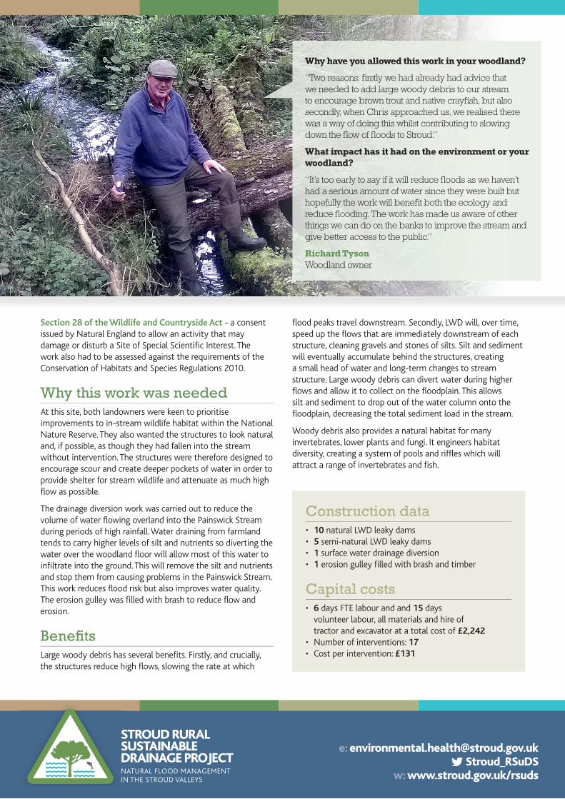
Why have you allowed this work in your woodland?
“Two reasons: fi rstly we had already had advice that we needed to add large woody debris to our stream to encourage brown trout and native crayfi sh, but also secondly, when Chris approached us, we realised there was a way of doing this whilst contributing to slowing down the fl ow of fl oods to Stroud.”
What impact has it had on the environment or your woodland?
“It’s too early to say if it will reduce fl oods as we haven’t had a serious amount of water since they were built but hopefully the work will benefi t both the ecology and reduce fl ooding. The work has made us aware of other things we can do on the banks to improve the stream and give better access to the public.”
Richard TysonWoodland owner
e: [email protected] Stroud_RSuDS
w: www.stroud.gov.uk/rsuds
STROUD RURALSUSTAINABLEDRAINAGE PROJECTNATURAL FLOOD MANAGEMENTIN THE STROUD VALLEYS
Section 28 of the Wildlife and Countryside Act - a consent issued by Natural England to allow an activity that may damage or disturb a Site of Special Scientifi c Interest. The work also had to be assessed against the requirements of the Conservation of Habitats and Species Regulations 2010.
Why this work was neededAt this site, both landowners were keen to prioritise improvements to in-stream wildlife habitat within the National Nature Reserve. They also wanted the structures to look natural and, if possible, as though they had fallen into the stream without intervention. The structures were therefore designed to encourage scour and create deeper pockets of water in order to provide shelter for stream wildlife and attenuate as much high fl ow as possible.
The drainage diversion work was carried out to reduce the volume of water fl owing overland into the Painswick Stream during periods of high rainfall. Water draining from farmland tends to carry higher levels of silt and nutrients so diverting the water over the woodland fl oor will allow most of this water to infi ltrate into the ground. This will remove the silt and nutrients and stop them from causing problems in the Painswick Stream. This work reduces fl ood risk but also improves water quality. The erosion gulley was fi lled with brash to reduce fl ow and erosion.
Benefi tsLarge woody debris has several benefi ts. Firstly, and crucially, the structures reduce high fl ows, slowing the rate at which
Construction data• 10 natural LWD leaky dams• 5 semi-natural LWD leaky dams• 1 surface water drainage diversion• 1 erosion gulley fi lled with brash and timber
Capital costs• 6 days FTE labour and and 15 days
volunteer labour, all materials and hire oftractor and excavator at a total cost of £2,242
• Number of interventions: 17• Cost per intervention: £131
fl ood peaks travel downstream. Secondly, LWD will, over time, speed up the fl ows that are immediately downstream of each structure, cleaning gravels and stones of silts. Silt and sediment will eventually accumulate behind the structures, creating a small head of water and long-term changes to stream structure. Large woody debris can divert water during higher fl ows and allow it to collect on the fl oodplain. This allows silt and sediment to drop out of the water column onto the fl oodplain, decreasing the total sediment load in the stream.
Woody debris also provides a natural habitat for many invertebrates, lower plants and fungi. It engineers habitat diversity, creating a system of pools and riffl es which will attract a range of invertebrates and fi sh.