Embed Size (px)
Citation preview

2011/9/21
1
VICENTE B. TUDDAO, JR., Ph.D.Executive DirectorRiver Basin Control OfficeRiver Basin Control OfficeDepartment of Environment and Natural Resources
Mandarin Oriental HotelMakati City, Metro ManilaSeptember 21, 2011
421 Principal rivers (421 river basins)
18 major river basins (with drainage area greater than1 000 sq km )than1,000 sq.km.)
72 lakes
Extensive groundwater aquifers

2011/9/21
2
Number Name of River Basin Drainage (sq. km.)
1 Cagayan 27,7532 Mindanao 23,1693 Agusan 11,9374 Pampanga 10,4345 Agno 5,9526 Abra 5,1257 Pasig-Laguna 4,6788 Bicol 3,7719 Abulug 3,37210 Tagum Libuganon 3,06411 Ilog-Hilabangan 1,94512 Panay 1,84313 Tagoloan 1,70414 1 614 Agus 1,64515 Davao 1,62316 Cagayan de Oro 1,52117 Jalaur 1,50318 Buayan-Malungan 1,434
TOTAL 112,473
37.50 % of the total land area of the Philippines

2011/9/21
3
25000
30000
5000
10000
15000
20000
MC
M
0
I Ab
ra
II C
agay
an
II A
bu
log
III P
amp
ang
a
III A
gn
o
IV P
asig
-Lag
un
a
V B
ico
l
VI J
alau
r
VI P
anay
VI I
log
- H
ilab
ang
an
VII
Ceb
u Is
lan
d
X A
gu
san
X T
ago
loan
X C
agay
an d
e O
ro
XI T
agu
m-
Lib
ug
ano
n
XI D
avao
XI B
uay
an-
Mal
un
go
n
XII
Ag
us
XII
Min
dan
ao
Water Resources Potential Water Demand in 2025
River Basin Information Brief
AGUS RIVER BASIN (RANAO RIVER BASIN)
6
Total Drainage Area: 1,645 Km Square

2011/9/21
4
TypeArea
ExtentAdministrative
CoverageInstitutional
Coordinating Agency
Type and Scope of River Basin/Watershed Management
PlansNation Whole Country National inter-agency
basin resources management forum/ national river basin
Coordination and prioritization of the different levels of basin management within a national strategy frameworknational river basin
management bodystrategy framework
River Basin Over
1000km2Typically the topographic boundaries would include land occurring within 3 or more provinces and 2 or more regions
River Basin Organization (RBO)/Authority that is inter-regional in extent
Plan aimed at broad sector development planning, and land use zoning. Identification of degraded and/or economically important medium to large watersheds within the river basin. Identification of medium-large areas in need of protected area statusstatus.
Large Watershed
500-1000 km2
Typically the topographic boundaries would include land occurring within 3 or more provinces and at least one but no more than 2 regions
Regional level watershed management council that is inter-provincial in extent
Plans aimed at identifying broad land use zones and areas (small to medium watersheds) where there is a need for improved watershed management. Identification of small-medium areas in need of protected area status.
Type Area ExtentAdministrative
CoverageInstitutional
Coordinating AgencyType and Scope of Basin
Management Plans
Medium Watershed
100-500 km2 Typically the topographic boundaries would include land occurring
Provincial level watershed ma
Plans aimed at identifying areaswithin the watershed where theris a need for field level activitiesImplementation plan targetsinclude land occurring
within at least one but no more than two provinces
Implementation plan targets activities only on the critical partof the watershed.
Small Watershed
10-100 km2 Typically the topographic boundaries would fall within one province and include land occurring within one or more municipalities
Provincial/ municipal level watershed management council/ committee
Plans aimed at field level implementation of improved watershed/ land management interventions. Plan covers the whole (or most of the) watershedand adjacent land of the participating communities.
Micro Watershed
Under 10 km2 Typically the topographic boundaries would fall within one municipality and include land occurring within one or at most two Barangays
Municipal/ Barangay community level watershed management council
Plans aimed at field level implementation of improved watershed/ land management intervention. Plan covers the whole watershed and adjacent land of the participating community

2011/9/21
5
Water Resource Water Resource Management Management FrameworkFramework
Watershed Managementframework
Integrated River Basin Integrated River Basin Management and DevelopmentManagement and Development
FrameworkFramework
Flood MitigationFlood Mitigationframeworkframework
Wetland Management Framework
FrameworkFrameworkPlan Plan
2011/9/21
6
UPLAND/FOREST
ECOSYSTEM
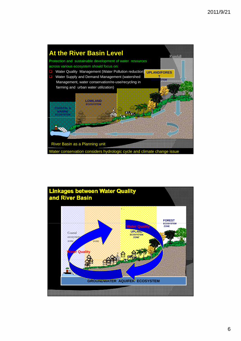
RainfallAt the River Basin LevelProtection and sustainable development of water resources
across various ecosystem should focus on:
Water Quality Management (Water Pollution reduction)
Water Supply and Demand Management (watershed
M t t ti / / li i
COASTAL & MARINE
ECOSYSTEM
+
LOWLANDECOSYSTEM
`Management, water conservation/re-use/recycling in
farming and urban water utilization)
River Basin as a Planning unit
Water conservation considers hydrologic cycle and climate change issue
• .
FOREST ECOSYSTEM
+
ECOSYSTEMZONE
UPLAND ECOSYSTEM
ZONE`
URBAN ecosystem zone
Coastal ecosystem zone
Water Quality
Water Quality
GROUNDWATER AQUIFER ECOSYSTEM

2011/9/21
7
The Philippine Clean Water Act 2004 The Philippine Clean Water Act 2004 (Republic Act No, 9275)(Republic Act No, 9275)
designate certain areas as water quality management area appropriate physiographic unitsmanagement area appropriate physiographic units such as watershed, river basins or water resources regions
similar hydrological, meteorological or geographic conditions which affect the physiochemical, biological and bacteriological reactions and diffusions of
ll t t i t b di th i hpollutants in water bodies or otherwise share common interest or face similar development programs, prospects, or problems
2011/9/21
8
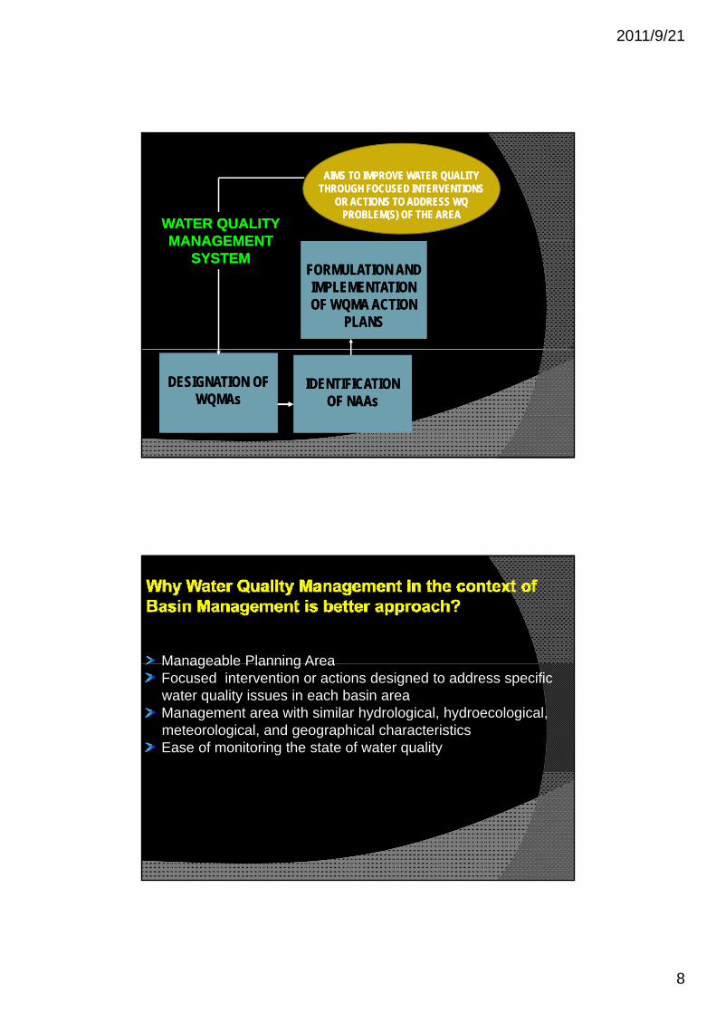
AIMS TO IMPROVE WATER QUALITY AIMS TO IMPROVE WATER QUALITY THROUGH FOCUSED INTERVENTIONS THROUGH FOCUSED INTERVENTIONS
OR ACTIONS TO ADDRESS WQ OR ACTIONS TO ADDRESS WQ PROBLEM(S) OF THE AREA PROBLEM(S) OF THE AREA
WATER QUALITYWATER QUALITYMANAGEMENTMANAGEMENT
WATER QUALITYWATER QUALITYMANAGEMENTMANAGEMENTMANAGEMENT MANAGEMENT
SYSTEMSYSTEMMANAGEMENT MANAGEMENT
SYSTEMSYSTEMFORMULATION AND FORMULATION AND IMPLEMENTATION IMPLEMENTATION OF WQMA ACTION OF WQMA ACTION
PLANSPLANS
DESIGNATION OF DESIGNATION OF WQMAsWQMAs
IDENTIFICATION IDENTIFICATION OF NAAsOF NAAs
Manageable Planning AreaManageable Planning AreaFocused intervention or actions designed to address specific water quality issues in each basin areaManagement area with similar hydrological, hydroecological, meteorological, and geographical characteristics Ease of monitoring the state of water quality

2011/9/21
9
Stakeholders Institutions EnvironmentStakeholders
Participation
Ownership
Voice and Representations
Poverty Reduction
Institutions
Laws and Policy
Capacity Building
Financial Sustainability
Environment
Quality
Life Support System
Productivity
Poverty Reduction Integrity
Dynamics of Water Quality, River Basin Managementand Governance in the Philippines
THE CASE OF THE CASE OF ILOILOILOILO--BATIANO RIVER BASIN:BATIANO RIVER BASIN:WATER QUALITY MANAGEMENT AREAWATER QUALITY MANAGEMENT AREA

2011/9/21
10
MAMBOG CREEK JIBAO
Sta. BarbaraSta. Barbara
San MiguelSan Miguel IloiloIloilo--BatianoBatianoRiver SystemRiver System
WQMAWQMA
ILOILO-BATIANO RIVER BASIN
CALAJUNAN CREEK
DUNGON CREEK
CREEK-JIBAO-AN RIVER
CABALUAN RIVER
PaviaPavia
OtonOton
ILOILO RIVER
BATIANO RIVER
Iloilo CityIloilo City
River Streamflow dynamics during high tideBackflow of water

2011/9/21
11
River Streamflow dynamics during low tide
WATER QUALITY
Delineation of WQMA and Sub-Basins Area
CABALUAN (SUB-BASIN 1)
MAMBOG-UPSTREAM
ILOILO (SUB-BASIN 2)
CALAJUNAN‐MIDSTREAM ILOILO
(SUB‐BASIN 3) DUNGON-DOWNSTREAM
BATIANO( SUB-BASIN 5)
( 3)DOWNSTREAM
ILOILO (SUB-BASIN 4)

2011/9/21
12
Monitoring Stations
Establishment of Water Quality Monitoring Stations
6 Stations Along Iloilo River (all in Iloilo City)
4 Stations Along Batiano River
3 Stations Along Calajunan Creek
2 Stations Along Dungon Creek
1 Station in Mambog Creek 1 Station in Mambog Creek
Calajunan Upstream
Calajunan Downstream
WATER QUALITY MONITORING STATIONS
Mambog Dam
Calajunan Downstream
Dungon Br.
Forbes Br.DungonCalajunan
Parola
Sooc Br.
Carpenter’s Bridge
Quirino Br.Mouth
B. Aquino Br.
Dumpsite
Sto Nino, Arevalo
CalumpangBr. Blvd Br.
Batiano Br., Oton

2011/9/21
13
Parameters Analyzed
Identification, Collection and Analysis of Water Quality Parameters
Parameters Analyzed
Biochemical Oxygen Demand, pH, Total Dissolved
Solid, Total Suspend Solid, Dissolved Oxygen,
Color and Temperature
Any effort to effectively and efficientlyAny effort to effectively and efficiently manage water quality of any water bodies can be achieved through river basin as aplanning unit.
The stakeholders and institution play major role in achieving effective water quality management using basin approach.

2011/9/21
14
Integration of water quality strategies and action plans at the river basin level integrated framework/master plan
Establishment and operationali ation of Ri er Basin Integrated Establishment and operationalization of River Basin Integrated Information Management System (RBIIMS) incorporating water quality parameters
Intensify law enforcement to apprehend violators of Clean Water Act
Strengthen participation and partnership in waterquality and river basin managementquality and river basin management
Creation and mobilization of River Basin Organization (RBO)in all river basin