Embed Size (px)
Citation preview
NEWHAVEN NEIGHBOURHOOD PLAN
Newhaven Town Council
REGULATION 16 SUBMISSION SUSTAINABILITY APPRAISAL (Including Strategic
Environmental Assessment)
January 2019
1

CONTENTS
Section Heading Page
1. Introduction 3
2. Background and Context 5
3. Appraisal Methodology 8
4. Regulation 14 Consultation and Scoping Report Comments 10
5. Newhaven Neighbourhood Plan and Town Portrait 12
6. Plans and Programmes 36
7. Sustainability Issues 41
8. Sustainability Framework - objectives 47
9. Policy Approaches and Options for Site Allocations 55
10. Appraising the Neighbourhood Plan Policies 63
11. Appraisal of alternatives and the cumulative effects of the plan 66
12 Mitigating and Monitoring 69
APPENDICES
A ChecklistB Responses to Scoping ReportC Relevant Plans and ProgrammesD Overall Policy ApproachesE Assessed policiesF Table of all policies assessed
2
1 INTRODUCTION
1.1 This report forms the Regulation 16 Sustainability Appraisal (SA) of the Submission
Newhaven Neighbourhood Plan. A Neighbourhood Plan, once adopted, becomes a
formal part of the planning system and will be a Local Development Plan document. The
Newhaven Neighbourhood Plan (NNP) is an important planning tool for shaping the
development and growth of the town.
What is a Sustainability Appraisal?
1.2 A Strategic Environmental Assessment (SEA) is a requirement of the EC Directive
2001/42/EC (the ‘Directive’) on the assessment of the effects of certain plans and
programmes on the environment. This is enshrined in United Kingdom (UK) law through
the Environmental Assessment of Plans and Programmes Regulations 2004, which
introduced environmental assessment as a requirement for most planning documents in
the UK. A sustainability appraisal is more comprehensive than strategic environmental
assessment since it covers the effects of plans on the economy and society, as well as
the environment. By undertaking a sustainability appraisal of the NP, the requirements of
the SEA Directive are fulfilled. Appendix A sets out the checklist which shows where the
SEA requirements are addressed in the report.
1.3 A Sustainability Appraisal (SA) is conducted in conformity with the SEA Directive.
However, while a SEA is concerned with environmental effects, the SA is an iterative
process that considers the environmental, social and economic consequences of a plan
and its policies and seeks to identify ways of achieving a proper balance between these
three considerations. For simplification, this report is referred to as the Sustainability
Appraisal throughout.
1.4 A SA is a systematic process to promote sustainable development by assessing the
extent to which a neighbourhood development plan, when judged against reasonable
alternatives, will help to achieve relevant environmental, economic and social objectives.
It is also a means of identifying and mitigating any potential adverse impacts that the
neighbourhood development plan might have. This can ensure that the policies in the
plan are the most appropriate, given the reasonable alternatives.
3
1.5 The NNP must be in conformity with the strategic policies of the local plan – the Lewes
District Local Plan Part 1 - Joint Core Strategy 2016 and the Submission South Downs
Local Plan 2018. These have been subject to its own sustainability appraisal
(incorporating a strategic environmental assessment) and this report has been informed
by information contained within that assessment.
1.6 This Report appraises the options (or reasonable alternatives) considered through the
preparation of the Newhaven Neighbourhood Plan, and subsequently the policies
contained within the Submission Neighbourhood Plan, against the sustainability
framework developed through the Scoping Report (September 2015). This will help to
gauge the extent to which the neighbourhood plan contributes towards sustainable
development.
4
2 BACKGROUND AND CONTEXT
What is Sustainable Development?
2.1 Sustainable development is defined as “development that meets the needs of the present
without compromising the ability of future generations to meet their own needs”. It is about
ensuring better quality of life for everyone, now and for generations to come. In doing so,
social, environmental and economic issues and challenges should be considered in an
integrated and balanced way.
2.2 The National Planning Policy Framework (NPPF) 2018 states the Government’s
intentions with regards to sustainable development, in particular the need for the planning
system to perform a number of roles:
a) an economic objective – to help build a strong, responsive and competitive economy,
by ensuring that sufficient land of the right types is available in the right places and at the
right time to support growth, innovation and improved productivity; and by identifying and
coordinating the provision of infrastructure;
b) a social objective – to support strong, vibrant and healthy communities, by ensuring that
a sufficient number and range of homes can be provided to meet the needs of present and
future generations; and by fostering a well-designed and safe built environment, with
accessible services and open spaces that reflect current and future needs and support
communities’ health, social and cultural well-being; and
c) an environmental objective – to contribute to protecting and enhancing our natural,
built and historic environment; including making effective use of land, helping to improve
biodiversity, using natural resources prudently, minimising waste and pollution, and
mitigating and adapting to climate change, including moving to a low carbon economy.
Consultation
2.3 An important part of the SA process is consultation with statutory environmental bodies,
wider statutory consultees and members of the community. The SA will be subject to the
same statutory consultation arrangements as the Neighbourhood Plan. Consultation
responses received in relation to the Scoping Report in 2015 are set out in Chapter 4.
5

2.4 The draft SA (April 2017) was consulted on as part of the Regulation 141 Pre-submission
stage. This exercise was undertaken between 3rd May and 21st July 2017. Details
regarding comments received are set out in Chapter 4.
Habitats Regulations Assessment
2.5 Article 6 of the Habitats Directive (92/43/EEC) requires all Member States to undertake an
‘appropriate assessment’ of any plan or project requiring authorisation which would be
likely to have a significant effect upon a European site (including Special Areas of
Conservation (SACs), Special Protection Areas (SPAs) and Ramsar wetland sites; this is
commonly referred to as a Habitats Regulations Assessment (HRA).
2.6 There are two internationally designated sites that lie within Lewes District. These are:
Castle Hill SAC located within Lewes District and Brighton & Hove; and,
Lewes Downs SAC located entirely within Lewes District.
Both of these are over 7km from the NP area and a direct impact from the policies or
objectives of the NNP is not expected.
2.7 A further two internationally designated sites are located within 20km of Lewes District.
These are: a). Pevensey Levels Ramsar & SAC located 10.3km east of Lewes District
within Wealden District; and, b) Ashdown Forest SPA and SAC located 5.1km north east
of Lewes District within Wealden District.
2.8 The Joint Core Strategy HRA scoped out any potential likely significant effects upon
Castle Hill SAC. It was therefore screened out from further consideration within the HRA.
With regard to Lewes Downs SAC, the Joint Core Strategy HRA undertook air quality
calculations (including consideration in combination with other projects and plans). This
concluded no adverse effect upon the integrity on Lewes Downs SAC would result alone
or ‘in combination’ with other projects and plans, a conclusion that has also been reached
in 2017 in the HRA of the South Downs Local Plan. As such Lewes Downs SAC was
screened out from further consideration in the HRA2.
2.9 The Joint Core Strategy HRA also concluded there to be no likely significant effects as a
result of development from Lewes District alone or in combination with other plans and
projects with regard to the Pevensey Levels Ramsar and SAC.
1 http://www.legislation.gov.uk/uksi/2012/637/regulation/14/made2 https://www.lewes-eastbourne.gov.uk/_resources/assets/inline/full/0/262298.pdf
6
2.10 The Joint Core Strategy HRA and a later Addendum undertook an ‘in combination’
assessment of Ashdown Forest SPA and SAC. This concluded that there would be no
adverse effect on the integrity of the designated site due to growth in Lewes ‘in
combination’ with that in other authorities, with the exception of ‘in combination’ impacts
resulting from increased recreational pressure. In response to this conclusion, Lewes
Joint Core Strategy policy was worded to include strategic recreational mitigation.
2.11 The Lewes Local Plan Part 2 HRA Assessment 2017 has undertaken a screening of
residential developments and settlements across the District. With regard to Newhaven it
states the following:
2.12 An HRA for Local Plan Part 2 was undertaken at Draft Plan stage and received
endorsement from Natural England on the conclusions of no Likely Significant Effect. The
HRA for the Pre-Submission Local Plan Part 2 and Neighbourhood Plans has been
updated and the conclusions remain the same3.
2.13 Lewes DC undertook a Habitat Regulations Screening Report fo the Newhaven
Neighbourhood Plan in 2015. Natural England agreed with the conclusion of the report
that there was no requirement to progress to further stages in the HRA process. It is
therefore concluded from the information set out in the HRAs for the Lewes Core Strategy
Parts 1 and 2 and the Screening Report 2015 that the NNP and its associated
development can be screened out of the Habitats Regulations Assessment.
3 https://www.lewes-eastbourne.gov.uk/_resources/assets/inline/full/0/276941.pdf
7
3 APPRAISAL METHODOLOGY
Introduction
3.1 The appraisal methodology has been prepared taking into account the processes set out
in the relevant guidance4.
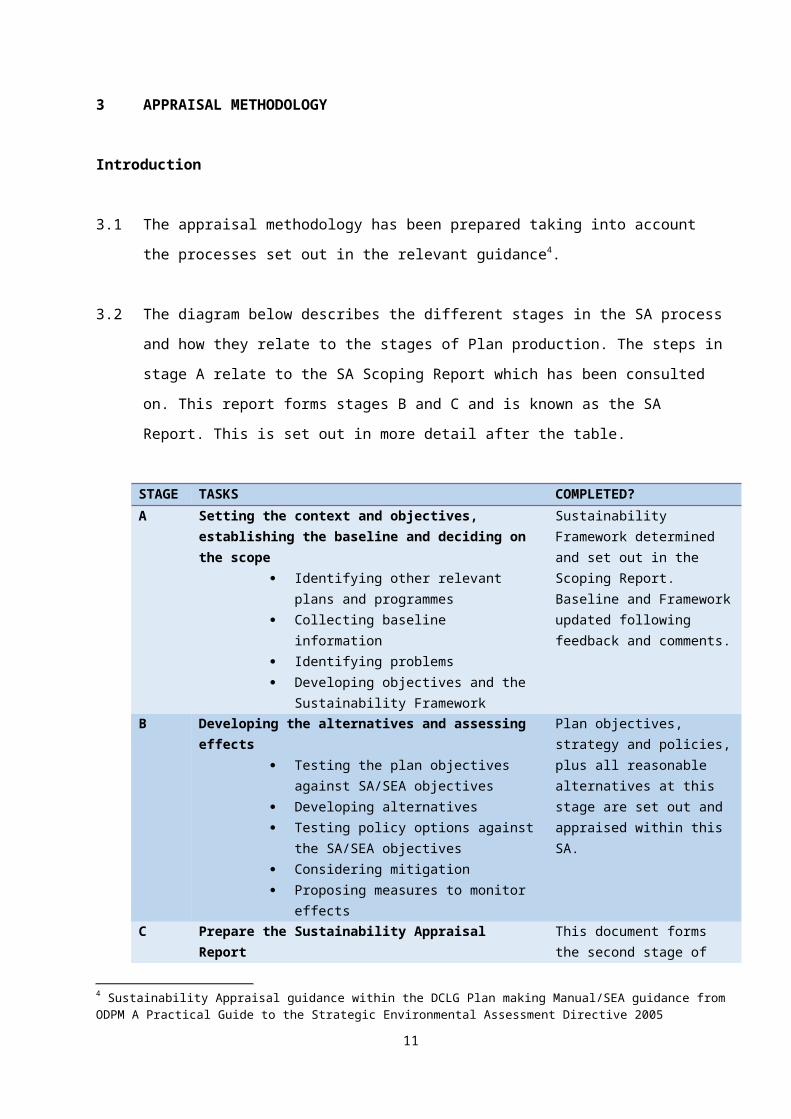
3.2 The diagram below describes the different stages in the SA process and how they relate
to the stages of Plan production. The steps in stage A relate to the SA Scoping Report
which has been consulted on. This report forms stages B and C and is known as the SA
Report. This is set out in more detail after the table.
STAGE
TASKS COMPLETED?
A Setting the context and objectives, establishing the baseline and deciding on the scope
Identifying other relevant plans and programmes
Collecting baseline information Identifying problems Developing objectives and the
Sustainability Framework
Sustainability Framework determined and set out in the Scoping Report. Baseline and Framework updated following feedback and comments.
B Developing the alternatives and assessing effects Testing the plan objectives against
SA/SEA objectives Developing alternatives Testing policy options against the
SA/SEA objectives Considering mitigation Proposing measures to monitor effects
Plan objectives, strategy and policies, plus all reasonable alternatives at this stage are set out and appraised within this SA.
C Prepare the Sustainability Appraisal Report This document forms the second stage of Stage C
D Consult on the SA Report Consultation undertaken on Pre-Submission SA in 2017. Consultation will be undertaken for the Submission version
E Monitor implementation of the plan To be completed
4 Sustainability Appraisal guidance within the DCLG Plan making Manual/SEA guidance from ODPM A Practical Guide to the Strategic Environmental Assessment Directive 2005
8
STAGE A: Setting the context and objectives, establishing the baseline and deciding on the scope
Sustainability Appraisal of the Newhaven Neighbourhood Plan – Scoping Report (September 2015)
3.3 Many of the tasks outlined in Stage A were undertaken during the Scoping report stage.
This included collecting the baseline information for Newhaven and developing the
Sustainability Appraisal framework. These areas of work have been updated to take into
account the responses received during the consultation period on the Scoping Report.
STAGE B: Developing the alternatives and assessing effects
Predicting Sustainability Effects of the Neighbourhood Plan
3.4 Stage B is the main focus of this Report. This stage uses the Framework set out in the
Scoping Report to appraise the planning policy options/reasonable alternatives consider
as a part of developing the Neighbourhood Plan.
3.5 The process of appraising the options/reasonable alternatives will highlight which option is
the most sustainable and also how, if necessary, it can be improved. Symbols are used to
record the performance of each option/alternative against each objective in the
sustainability framework.
3.6 The assessment and predictions of the effect of policy options on the sustainability
objectives is set out within the SA. These predictions and judgements have been made
based on the background baseline information and the comments/feedback provided by
the Town Council through their discussions with the residents and local community.
STAGES C, D AND E: Prepare the SA Report, Consult and Monitor the Plan
3.7 Stage C of the process is the preparation of this SA report and consultation at the stages
set out in the Regulations.
9
4. REGULATION 14 CONSULTATION AND SCOPING REPORT COMMENTS
Regulation 14
4.1 The Pre-submission version of the SA was consulted on at the same time as the NNP.
This was 3rd May and 21st July 2017. A wide range of organisations were consulted
including the environmental bodies, the County Council, South Downs National Park
Authority and Lewes District Council. Information was placed on the Town Council’s
website and members of the local community were encouraged to respond during the
consultation period.
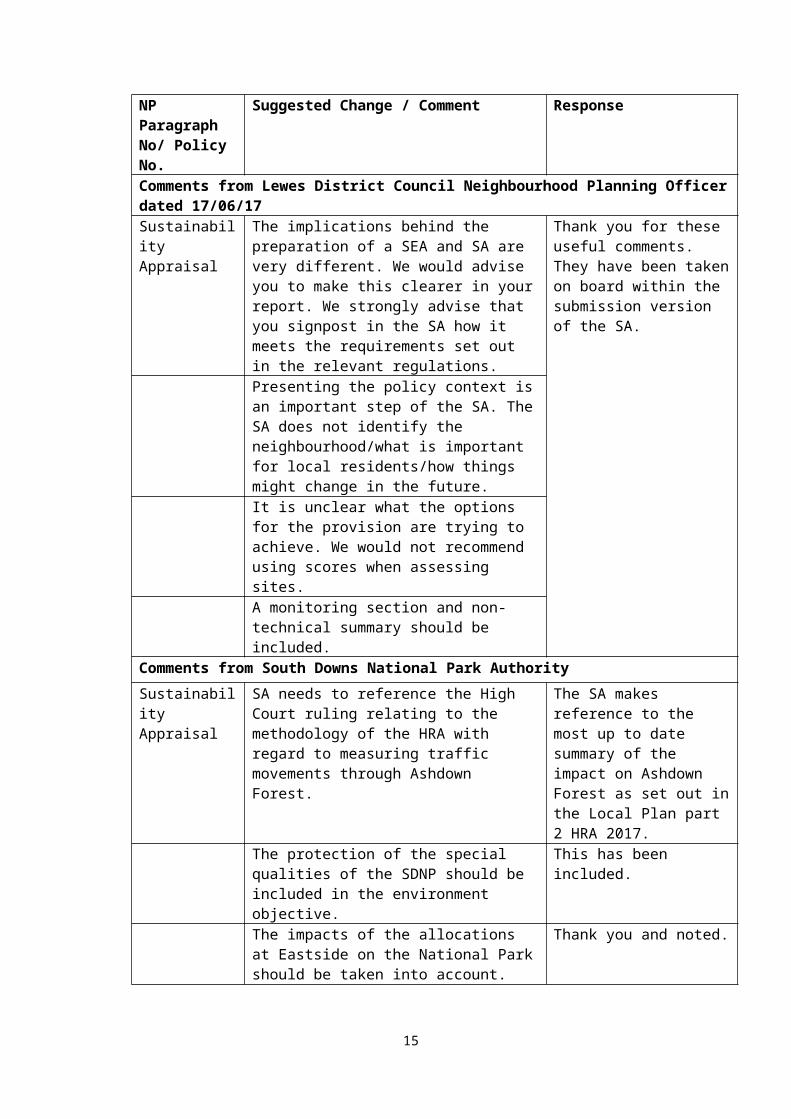
4.2 A range of detailed comments were received on most aspects of the NP. However –
comments on the SA were limited5. These are set out below together with the
recommended response:
NP Paragraph No/ Policy No.
Suggested Change / Comment Response
Comments from Lewes District Council Neighbourhood Planning Officer dated 17/06/17Sustainability Appraisal
The implications behind the preparation of a SEA and SA are very different. We would advise you to make this clearer in your report. We strongly advise that you signpost in the SA how it meets the requirements set out in the relevant regulations.
Thank you for these useful comments. They have been taken on board within the submission version of the SA.
Presenting the policy context is an important step of the SA. The SA does not identify the neighbourhood/what is important for local residents/how things might change in the future. It is unclear what the options for the provision are trying to achieve. We would not recommend using scores when assessing sites. A monitoring section and non-technical summary should be included.
Comments from South Downs National Park Authority
Sustainability Appraisal
SA needs to reference the High Court ruling relating to the methodology of the HRA with regard to measuring traffic movements through Ashdown Forest.
The SA makes reference to the most up to date summary of the impact on Ashdown Forest as set out in the Local Plan part 2 HRA 2017.
The protection of the special qualities of the SDNP should be included in the
This has been included.
5 Copies of all responses received on the draft SA and NNP are held with the Town Council.
10
environment objective.The impacts of the allocations at Eastside on the National Park should be taken into account.
Thank you and noted.
4.3 The Scoping Report identified a number of social, environmental and economic
sustainability issues facing the settlements. The Scoping Report was consulted on in
September 2015.
Consultation Responses on Scoping Report
4.4 The consultation included the statutory bodies with environmental responsibilities – the
Environment Agency, Historic England and Natural England as well as a number of other
organisations and authorities.
4.5 All the responses have been collated and those that are of relevance to the SA have been
considered and incorporated within this document. A summary of the comments made
and responses are set out in Appendix B of this report.
11

5. TOWN PROFILE
5.1 Lewes District Council has designated Newhaven Parish as a neighbourhood area in
order to allow the Town Council the opportunity to produce a Neighbourhood
Development Plan. Map 1 shows the Neighbourhood Plan boundary. This covers the
Parish area of which most of it is the urban town of Newhaven. However, a section either
side of the River Ouse is excluded from the neighbourhood plan rea. Within this report –
the word town is used rather than parish.
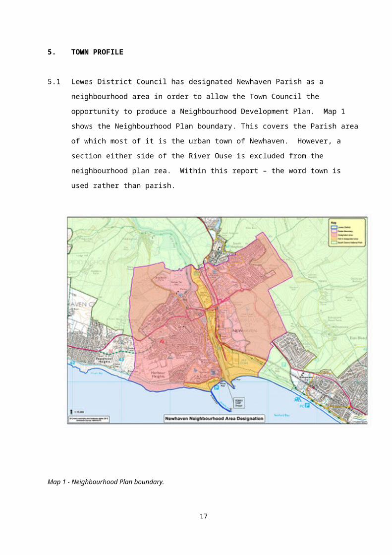
Map 1 - Neighbourhood Plan boundary.
5.2 Producing a Neighbourhood Plan is not compulsory and many areas have decided not to
plan locally for their area, but rather leave it to the local planning authority to decide how
their local areas are to grow and change. One of the comments often made by local
people is that over the years Newhaven has been forgotten and often had development
forced upon it that has been to its detriment, and that no other place would want. In
addition, over the last few decades, the town has suffered from a lack of investment, a
loss of industry and negative impacts on the public realm which have eroded community
and wider perceptions of the cultural value of the town.
12
5.3 In recent years the town has experienced some regeneration, but like other areas has
been the victim of the economic downturn, with investment reducing and previous
industries falling out of favour. Consequently, many local people seek work out of
Newhaven. It is recognised that Newhaven continues to need considerable investment,
and regeneration of the town remains a priority at regional and local government level.
5.4 These issues along with the reduction in public spending and private investment have put
a strain on the town and in certain areas, such as the town centre, this is particularly
evident.
5.5 Despite these challenges, there remains a strong sense of optimism and this is for good
reason. As well as its history and beautiful setting, Newhaven has redevelopment and
regeneration opportunities. Key to change will be respecting the characteristics and
qualities which give Newhaven its unique sense of place, whilst using opportunities
created by development to strengthen and enhance its image
5.6 Newhaven is identified in the Lewes District Joint Core Strategy at Spatial Policy 2 to
receive an additional 825 new homes. Spatial Policy 7 allocates 20 hectares of land at
Harbour Heights for a mixed-use development, including employment units and
approximately 400 dwellings. The remaining 425 can be allocated either through the
Neighbourhood Plan process or Lewes District Council’s Local Plan Part 2: Site
Allocations and Development Management Policies document, which is in the early
stages of preparation.
5.7 In addition to these ‘planned’ homes, planning permission has already been given for
some 700 dwellings on large and small sites. The availability of underused and vacant
areas of the town centre, the opportunities for redevelopment presented by many
brownfield sites, along with the designation of an Enterprise Zone have created a ‘once in
a generation’ opportunity for positive change, building on Newhaven’s maritime and
manufacturing past to enhance this unique and charming town.
5.8 Newhaven has a strong sense of identity which is enhanced by the background of the
South Downs, the adjacent River Ouse and the coast. It is a medium sized town with a
population of just under 13,000 and has a range of characteristics that are in parts urban,
rural and coastal.
13
5.9 In order to be able to identify the impact the Neighbourhood Plan will have on sustainable
development, it is important to have an understanding of the baseline conditions that exist
within the town and the trends that may continue if there were no Neighbourhood Plan
prepared. The information has been structured using a series of topics, which are
predominantly influenced and derived from those set out in the SEA Regulations 2004, in
particular Schedule 2.
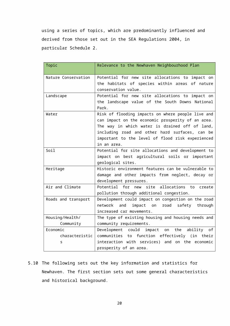
Topic Relevance to the Newhaven Neighbourhood Plan
Nature Conservation Potential for new site allocations to impact on the habitats of species within areas of nature conservation value.
Landscape Potential for new site allocations to impact on the landscape value of the South Downs National Park.
Water Risk of flooding impacts on where people live and can impact on the economic prosperity of an area. The way in which water is drained off of land, including road and other hard surfaces, can be important to the level of flood risk experienced in an area.
Soil Potential for site allocations and development to impact on best agricultural soils or important geological sites.
Heritage Historic environment features can be vulnerable to damage and other impacts from neglect, decay or development pressures.
Air and Climate Potential for new site allocations to create pollution through additional congestion.
Roads and transport Development could impact on congestion on the road network and impact on road safety through increased car movements.
Housing/Health/Community The type of existing housing and housing needs and community requirements.
Economic characteristics Development could impact on the ability of communities to function effectively (in their interaction with services) and on the economic prosperity of an area.
5.10 The following sets out the key information and statistics for Newhaven. The first section
sets out some general characteristics and historical background.
General Background to Newhaven
5.11 The modern parish of Newhaven has a wealth of evidence for past human activity for all
periods from the ‘Ice Age’ to the present day. This is reflected in the fact that there are 2
scheduled monuments, 21 listed buildings and 2 conservation areas. The name
‘Newhaven’ is derived from the artificial creation of a new mouth for the River Ouse from
the mid-16th Century and replaced the earlier name of ‘Meeching’ which is still referenced
throughout the town today.
14
5.12 Newhaven grew substantially in the late 19th Century and many of the buildings in the
central area are from this period. So too are the Lunette Battery, built in 1855 located on
the shore near the west pier and Newhaven Fort, commenced in 1862, both built to
defend the port of Newhaven. Post war development on the fringes of the town and more
recently waterfront development has added to the layers of Newhaven’s history but still
the towns is dominated by its local geography and maritime and manufacturing past.
5.13 Today the people of Newhaven remain proud of the town’s heritage which manifests most
strongly in its culture. Newhaven is still an important gateway to Europe and has a key
strategic location, placed within short distances of the City of Brighton, the County town of
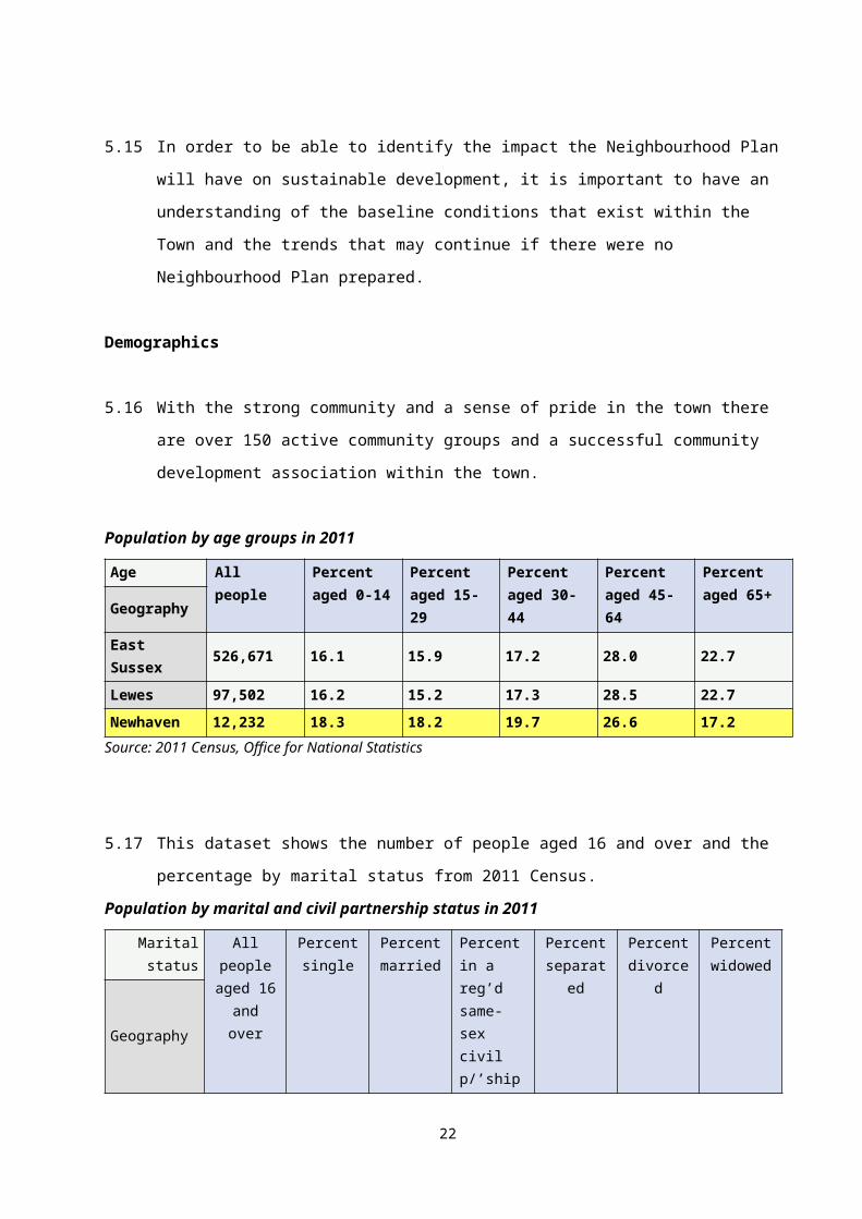
Lewes, the resort of Eastbourne and the South Downs National Park.
5.14 The following statistics and evidence are primarily drawn from the 2011 Census. These
are used to provide an overview of the current status of the community. Other sources of
data or information are acknowledged where applicable.
5.15 In order to be able to identify the impact the Neighbourhood Plan will have on sustainable
development, it is important to have an understanding of the baseline conditions that exist
within the Town and the trends that may continue if there were no Neighbourhood Plan
prepared.
Demographics
5.16 With the strong community and a sense of pride in the town there are over 150 active
community groups and a successful community development association within the town.
Population by age groups in 2011
Age All people Percent aged 0-14
Percent aged 15-29
Percent aged 30-44
Percent aged 45-64
Percent aged 65+Geography
East Sussex 526,671 16.1 15.9 17.2 28.0 22.7
Lewes 97,502 16.2 15.2 17.3 28.5 22.7Newhaven 12,232 18.3 18.2 19.7 26.6 17.2
Source: 2011 Census, Office for National Statistics
5.17 This dataset shows the number of people aged 16 and over and the percentage by
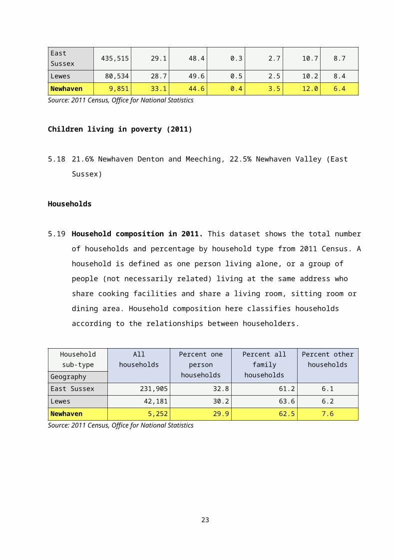
marital status from 2011 Census.
15
Population by marital and civil partnership status in 2011
Marital status All people aged 16 and over
Percent single
Percent married
Percent in a reg’d same-sex civil p/’ship
Percent separated
Percent divorced
Percent widowed
Geography
East Sussex
435,515 29.1 48.4 0.3 2.7 10.7 8.7
Lewes 80,534 28.7 49.6 0.5 2.5 10.2 8.4
Newhaven 9,851 33.1 44.6 0.4 3.5 12.0 6.4Source: 2011 Census, Office for National Statistics
Children living in poverty (2011)
5.18 21.6% Newhaven Denton and Meeching, 22.5% Newhaven Valley (East Sussex)
Households
5.19 Household composition in 2011. This dataset shows the total number of households
and percentage by household type from 2011 Census. A household is defined as one
person living alone, or a group of people (not necessarily related) living at the same
address who share cooking facilities and share a living room, sitting room or dining area.
Household composition here classifies households according to the relationships between
householders.
Household sub-type
Allhouseholds
Percent one person
households
Percent all family households
Percent other households
Geography
East Sussex 231,905 32.8 61.2 6.1
Lewes 42,181 30.2 63.6 6.2
Newhaven 5,252 29.9 62.5 7.6Source: 2011 Census, Office for National Statistics
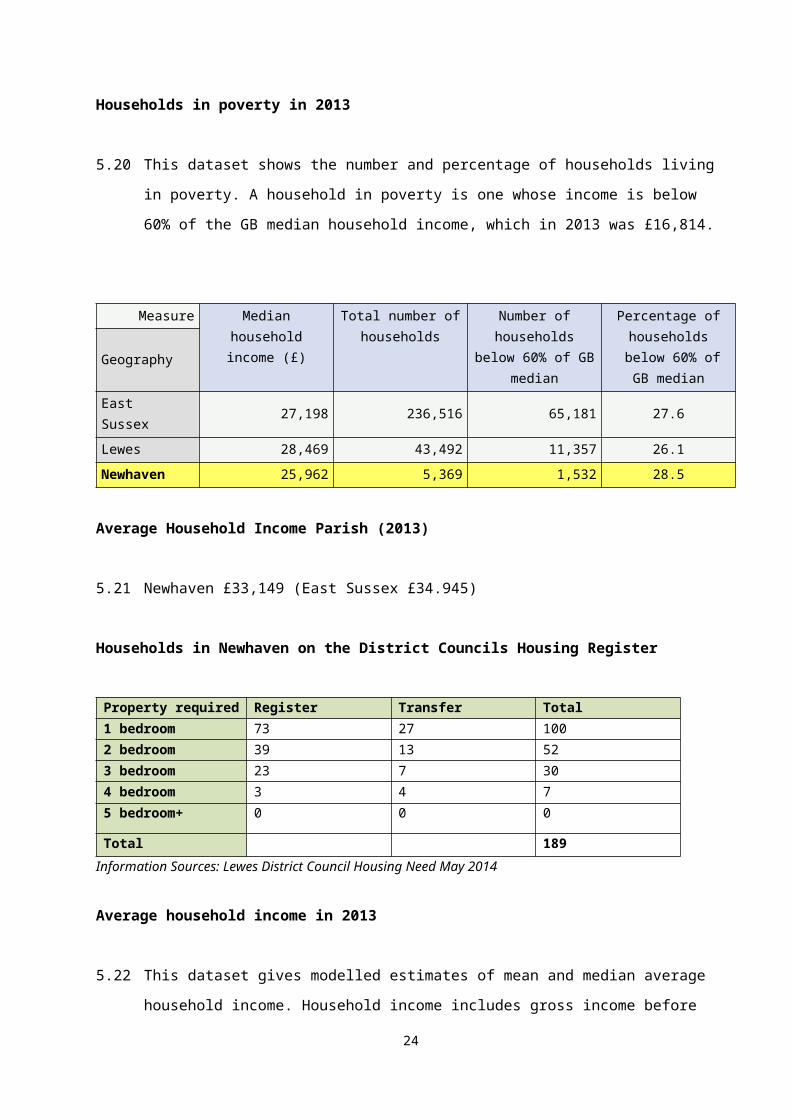
Households in poverty in 2013
16
5.20 This dataset shows the number and percentage of households living in poverty. A
household in poverty is one whose income is below 60% of the GB median household
income, which in 2013 was £16,814.
Measure Median household income (£)
Total number of households
Number of households below 60% of GB median
Percentage of households
below 60% of GB median
Geography
East Sussex 27,198 236,516 65,181 27.6
Lewes 28,469 43,492 11,357 26.1
Newhaven 25,962 5,369 1,532 28.5
Average Household Income Parish (2013)
5.21 Newhaven £33,149 (East Sussex £34.945)
Households in Newhaven on the District Councils Housing Register
Property required Register Transfer Total1 bedroom 73 27 1002 bedroom 39 13 523 bedroom 23 7 304 bedroom 3 4 75 bedroom+ 0 0 0
Total 189Information Sources: Lewes District Council Housing Need May 2014
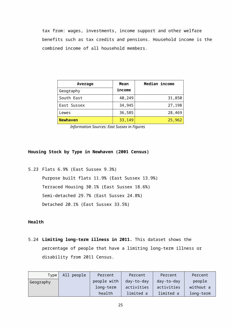
Average household income in 2013
5.22 This dataset gives modelled estimates of mean and median average household income.
Household income includes gross income before tax from: wages, investments, income
support and other welfare benefits such as tax credits and pensions. Household income is
the combined income of all household members.
Average Mean income
Median incomeGeography
South East 40,249 31,850
17
East Sussex 34,945 27,198
Lewes 36,585 28,469
Newhaven 33,149 25,962Information Sources: East Sussex in Figures
Housing Stock by Type in Newhaven (2001 Census)
5.23 Flats 6.9% (East Sussex 9.3%)
Purpose built flats 11.9% (East Sussex 13.9%)
Terraced Housing 30.1% (East Sussex 18.6%)
Semi-detached 29.7% (East Sussex 24.8%)
Detached 20.1% (East Sussex 33.5%)
Health
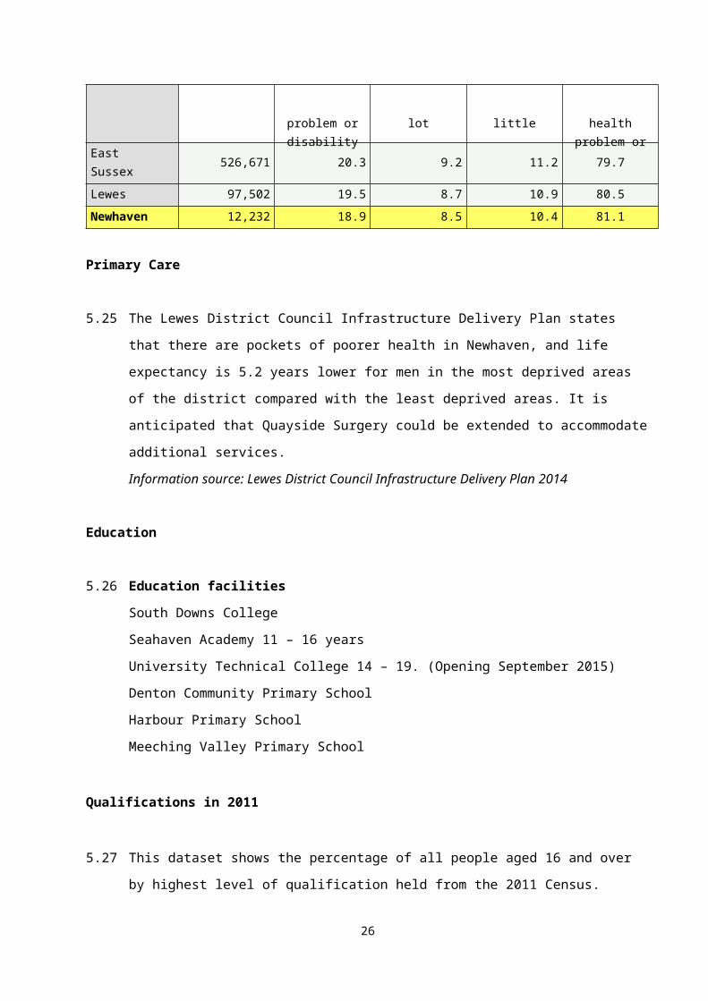
5.24 Limiting long-term illness in 2011. This dataset shows the percentage of people that
have a limiting long-term illness or disability from 2011 Census.
Type All people Percent people with long-term health problem
or disability
Percent day-to-day activities limited a lot
Percent day-to-day activities limited a little
Percent people without a long-
term health problem or disability
Geography
East Sussex 526,671 20.3 9.2 11.2 79.7
Lewes 97,502 19.5 8.7 10.9 80.5
Newhaven 12,232 18.9 8.5 10.4 81.1
Primary Care
5.25 The Lewes District Council Infrastructure Delivery Plan states that there are pockets of
poorer health in Newhaven, and life expectancy is 5.2 years lower for men in the most
deprived areas of the district compared with the least deprived areas. It is anticipated that
Quayside Surgery could be extended to accommodate additional services.
Information source: Lewes District Council Infrastructure Delivery Plan 2014
Education
5.26 Education facilities
18
South Downs College
Seahaven Academy 11 – 16 years
University Technical College 14 – 19. (Opening September 2015)
Denton Community Primary School
Harbour Primary School
Meeching Valley Primary School
Qualifications in 2011
5.27 This dataset shows the percentage of all people aged 16 and over by highest level of
qualification held from the 2011 Census.
Qualifications All usual residents aged 16 and over
No qualific-ations
Highest level of
qualification: Level
1
Highest level of
qualification: Level 2
Highest level of qualification:
Apprenticeship
Highest level of qualification:
Level 3
Highest level of
qualification: Level 4 and
above
Geography
East Sussex
100.0 22.6 14.1 16.8 3.5 12.0 26.2
Lewes 100.0 21.5 13.8 15.7 3.4 11.8 29.4
Newhaven 100.0 25.6 18.5 16.7 3.5 12.4 18.6
Five or more GCSE passes at A* – C (2011/2012)
5.28 Tideway School Seahaven Academy, in Newhaven has a 37.9% pass rate for Grades A*
to C, the lowest of all the secondary schools in the Lewes District. This falls below the
East Sussex average figure of 57.5%. The University Technical College is in its second
year of operation and there is no data available currently for Key Stage 4 performance.
Information Source: East Sussex in Figures
Early years and childcare
5.29 East Sussex County Council (ESCC) has advised that there will be shortfalls in Early
Years provision in Newhaven These shortfalls will be accommodated through the
establishment of new facilities on new sites (owned by the County Council) and/or
through expansion of existing provision in the respective settlements.
19
5.30 It is likely that further contributions from new housing development will be required if the
gap increases between government funding and the actual cost of providing necessary
Early Years provision in the right location. Future education infrastructure requirements
will be subject to review as new information on pupil/child number forecasts becomes
available.
Primary Schools
5.31 ESCC advise that the recent opening of Newhaven Academy (to be re-named High Cliff
Academy for 2018 admissions) along with the expansion of existing primary schools will
meet the primary school demand in Newhaven, over the Core Strategy (and
Neighbourhood Plan) period.
Secondary Schools
5.32 ESCC has advised that there will be shortfalls in secondary school provision in Newhaven
over the Core Strategy period. These shortfalls will be accommodated through the
establishment of new schools on new sites (owned by the County Council) and/or through
expansion of existing schools.
Green Infrastructure
5.33 Green infrastructure comprises of a range of open spaces such as formal and informal
recreation areas, green corridors, parks and gardens, allotments, accessible countryside
in urban fringe areas and cemeteries. Formal recreational facilities include:
Fort Road Recreation Ground
Lewes Road Recreation Ground
Denton recreation Ground
Eastside recreation Ground
Meeching Valley Recreation Ground
Valley Recreation Ground
5.34 Lewes District Council Outdoor Play space Review 2004 identified:
20
there is an overall undersupply (3.1 acres) in the total number of football pitches in
Newhaven
there are no hockey or rugby clubs based within the town as there are no facilities
and therefore no hockey or rugby pitch surpluses or shortfalls have yet been
identified. Newhaven Hockey Club is currently based in Seaford and would like to
relocate back to their home town.
there is a small number of football clubs with Newhaven based players who travel to
home grounds in other parts of district in order to have access to pitches.
there is a small under-supply of 1.5 cricket pitches.
5.35 Informal Recreational Space - Older parts of the town have little civic or amenity
greenspace, which indicates the need for pocket parks and improved linkages where
possible. Every opportunity should be explored and taken to enhance the river spaces
and the beach to provide high quality and characterful recreational spaces. Newhaven’s
setting enables local people in the north, west and southern parts to have access to the
surrounding countryside; downland, sea cliffs, river landscapes and seaside. People in
the Town Centre lack access to areas of high quality civic space. There is no area of
parkland with high quality gardens, but areas such as West Quay offer a high quality
amenity area of a maritime character. The river, while providing wonderful character, acts
as a severing agent, cutting the town in half, thus reducing linkages across. The ring-road
in the centre has a similar effect.
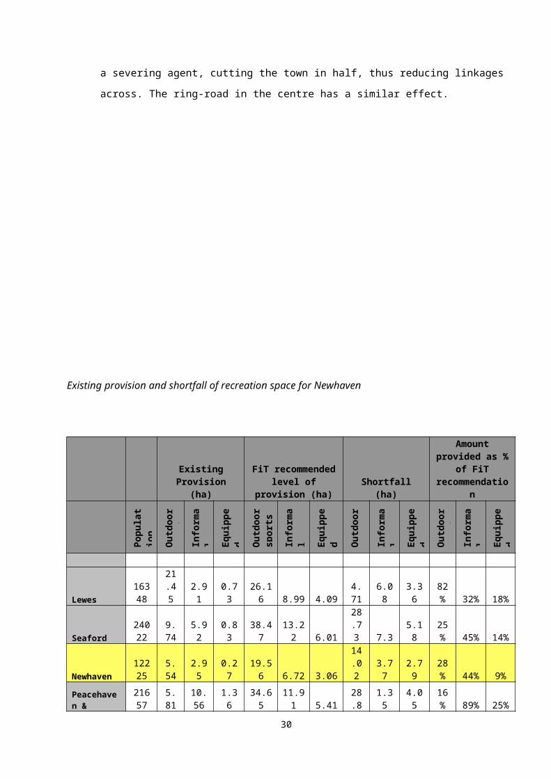
Existing provision and shortfall of recreation space for Newhaven
21
Allotments
5.36 47 allotment plots at land off Lewes Road, with 37 people on the waiting list as at May
2014.
Car ownership
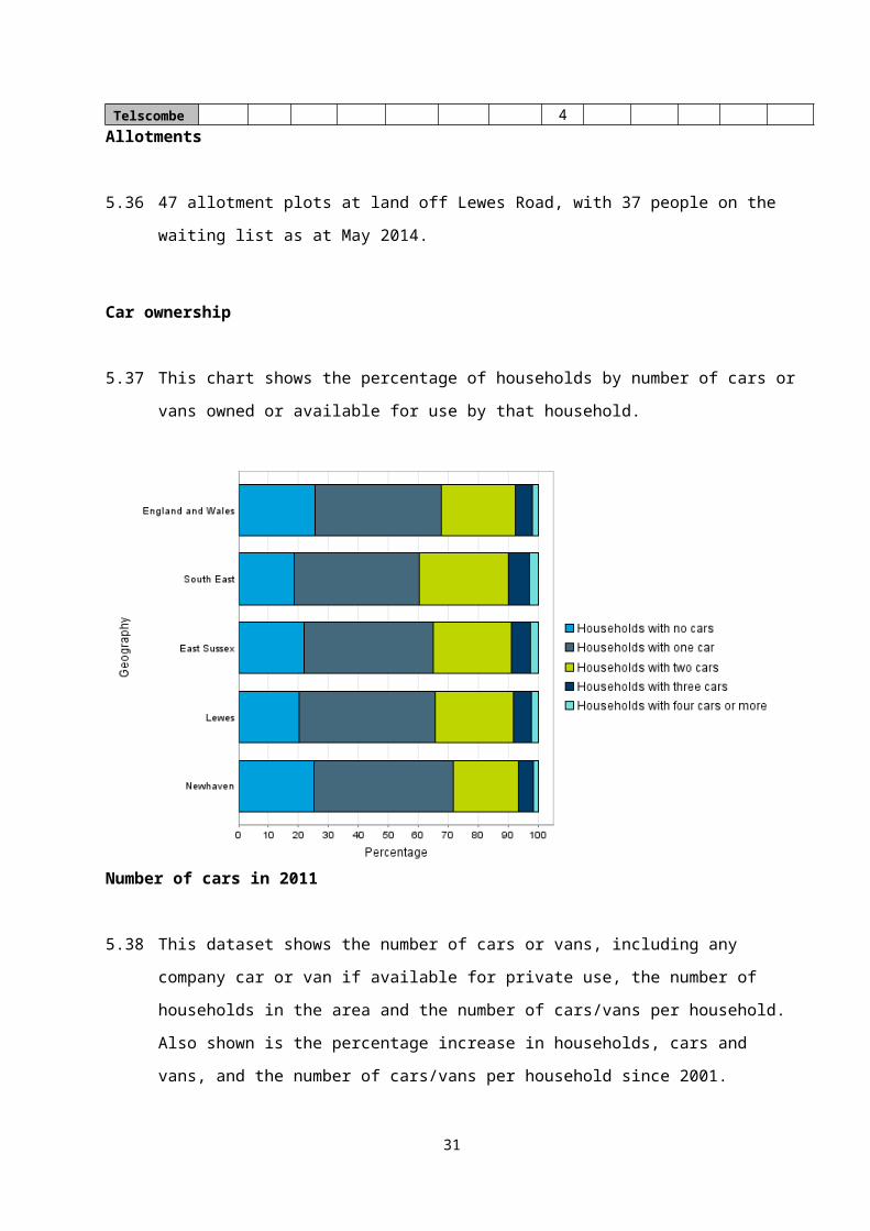
5.37 This chart shows the percentage of households by number of cars or vans owned or
available for use by that household.
22
Existing
Provision (ha)
FiT recommended level of provision
(ha) Shortfall (ha)
Amount provided as % of
FiT recommendation
Popu
lati
on Out
door
sp
orts
Info
rmal
ch
ildre
n'
Equi
ppe
d Out
door
sp
orts
Info
rmal
ch
ildre
n's
play
Eq
uipp
ed ch
ildre
n'O
utdo
or
spor
tsIn
form
al
child
ren'
Equi
ppe
d Out
door
sp
orts
Info
rmal
ch
ildre
n'
Equi
ppe
d
Lewes1634
821.45 2.91 0.73
26.16 8.99 4.09
4.71 6.08 3.36
82% 32% 18%
Seaford2402
29.74 5.92 0.83
38.47
13.22 6.01
28.73 7.3 5.18
25% 45% 14%
Newhaven1222
55.54 2.95 0.27
19.56 6.72 3.06
14.02 3.77 2.79
28% 44% 9%
Peacehaven & Telscombe
21657
5.81
10.56 1.36
34.65
11.91 5.41
28.84 1.35 4.05
16% 89% 25%
Number of cars in 2011
5.38 This dataset shows the number of cars or vans, including any company car or van if
available for private use, the number of households in the area and the number of
cars/vans per household. Also shown is the percentage increase in households, cars and
vans, and the number of cars/vans per household since 2001.
Measure All cars or vans in the area
All households
Number of vehicles per householdGeography
East Sussex 292,118 231,905 1.3
Lewes 53,124 42,181 1.3
Newhaven 5,853 5,252 1.1
Method of travel to work in 2011
5.39 This dataset shows which modes of transport are used by those who are in employment
to get to their place of work, by broad transport type. The information in this table has
been produced using only people's response to method of travel to work questions in the
2011 Census this data is not comparable with 2001.
Mode of travel to work
All people aged
16-74 in employment
Percentage of people
who work at or mainly
from home
Percentage of people who use public transport
Percentage of people who use a
private vehicle
Percentage of people
who walk or cycle
Percentage of people who use another mode of transport
Geography
East Sussex
239,319 7.9 11.4 66.8 13.3 0.6
Lewes 45,532 8.0 16.0 62.6 12.8 0.6
Newhaven 5,899 3.8 14.4 65.6 15.7 0.5
Information Sources: 2011 Census, Office for National Statistics
Trains
5.40 The town has two railway stations offering direct train services to London, Lewes, Seaford
and Brighton.
Buses
23
5.41 There is a regular bus service from Newhaven to Brighton, Seaford and Eastbourne
(Brighton and Hove Bus Company) and a more infrequent service to Lewes (Rider Bus)
Cycling
5.42 National Cycle route 2 (part of the London to Paris cycle way) goes through Newhaven
and provides a cycle path to Seaford and beyond.
Brighton to Newhaven Coast Loop cycle route (19.5 miles)
Brighton to Eastbourne Cycle route (34 miles)
5.43 A cycle route (Egrets Way) linking Newhaven to Lewes is partially complete with sections
yet to be identified and provided.
5.44 In November 2013 a public consultation exercise was undertaken by East Sussex County
Council to seek people’s views about proposed pedestrian, cycling and bus
improvements in Newhaven and Peacehaven. The following results were obtained:
75% of respondents supported or strongly supported the proposal for a
cycle/pedestrian facility from the A259 Brighton Road in Peacehaven to Newhaven
Town Centre;
45% of respondents preferred using the route that ran through Upper Valley Road,
Northdown Road, First Avenue and Second Avenue while 55% preferred using the
A259 then Polyclinic access road to the south to go to and from Newhaven town
centre;
50% of respondents supported or strongly supported the use of the High Street and
St Luke's Lane, Newhaven by cyclists;
66% of respondents supported or strongly supported the provision of additional
cycling and pedestrian facilities in the Denton area of Newhaven.
Local Highway and accessibility improvements
5.45 ESCC have identified that in Newhaven the planned development needs to be supported
by a range of transport measures to mitigate congestion and increase highway capacity,
including:
Junction improvements on the Newhaven town centre ring road
24
Improvements to the A259/A26 junction in Newhaven
Demand management measures on the A259 corridor, focussed on maximising bus
use
Improvements to bus infrastructure and the walking and cycling network
Heritage and Archaeology6
5.46 Newhaven’s history since the 16th century has been dominated by the physical and
economic development of its harbour, with large-scale expansion of shipping activity and
the town from the arrival of the railway (1847). Commercial development and associated
infrastructure (such as the inner ring road) have not favoured the conservation of historic
fabric, but some buildings have survived. The church is the sole remnant of the medieval
village, but there are several 18th -century houses in the town. Key survivals from the
19th century include the 1860s fort and adjacent lunette battery, and numerous works
from harbour improvements such as workshops on the eastern quay, the town station, the
west pier and the eastern breakwater. Less visible is the archaeological evidence of the
earlier town, whose origins lie in the pre-Conquest village.
5.47 Newhaven has eight buildings that date from c.1540-1845, six dating from the 18th
century and two from the early 19th century. The 18th-century buildings include a small
concentration near the junction of High Street and Chapel Street. The early 19th century
is marked by two buildings that reflect the expansion of emergent town: the
Congregationalist Church, South Way, of 1841. The survival of maps from the 18th
century onwards confirms what the minimal architectural and archaeological evidence
suggest: that the centre of the village/town at this date was the area around the lower end
of the High Street. As late as 1838 (tithe map), built-up streets were limited to the parts of
High Street and Chapel Street now encompassed by the ring road. The northern edge of
the town was skirted by what appears to have been a lesser street providing access to
the wharves north of the ferry/bridge, roughly along the line of modern North Way. Minor
lanes between High Street plots survive as South Lane and St Luke’s Lane, while what is
now Bridge Street was largely unbuilt and terminated at a large meadow (known as
‘Knowles’) that occupied the bend in the river to the east and south-east of the town.
5.48 There are 2 scheduled monuments, 21 listed buildings and 2 conservation areas within
the town. The extensive archaeological interest of the parish is represented by 13 6 Extracts taken from Newhaven Historic Character Assessment Report 2004 https://www.lewes-eastbourne.gov.uk/planning-and-building-control/conservation/extensive-urban-surveys/?p=7
25
archaeological notification areas and 58 recorded archaeological surveys, watching briefs
or archaeological excavations. These are shown on the plan below:
Areas of Archaeological Interest
Conservation Areas and Listed Buildings
5.49 Denton Conservation Area. The key positive characteristics are:
Location between the South Downs and the River Ouse;
26

Small linear village based around two streets;
The architectural and historic interest of the area's buildings, many of which are listed;
The prominent position of St. Leonard's Church;
Graveyard detached from the church;
Concentration of historic buildings around church;
Attractive mix of cottages, houses and converted farm buildings;
Semi-rural character reinforced by the flint walls and tree groups;
Use of vernacular materials including flint, brick, clay tiles and slate;
20th century development, while prominent, has not spoilt the historic core of the
village;
The lack of significant vehicular traffic through the village; the tranquil atmosphere.
5.50 Church Hill Conservation Area. The Conservation Area comprises three main
elements, the Parish Church of St Michael and All Angels, the Old Rectory and the Listed
walls. The buildings are detached structures set within spacious separate contained
areas.
5.51 Listed buildings. The following are the Listed Buildings within Newhaven:
Grade II 1-3, Chapel Street, Newhaven, Lewes, East Sussex, BN9
Grade II 19, High Street Newhaven, Lewes, East Sussex, BN9
Grade II 3, 4 and 5, Vicarage Close Newhaven, Lewes, East Sussex, BN9
Grade II 5, Chapel Street Newhaven, Lewes, East Sussex, BN9
Grade II 60-66, Denton Road Newhaven, Lewes, East Sussex, BN9
Grade II* Church of St Leonard Newhaven, Lewes, East Sussex, BN9
Grade II* Church of St Michael and All Angels Newhaven, Lewes, East Sussex, BN9
Grade II Manor House with Gate piers, Walls and Gates Newhaven, Lewes, East Sussex,
BN9
Grade II Memorial to Captain James Hanson and the Crew of Hms Brazen Newhaven,
Lewes, East Sussex, BN9
Grade II National Westminster Bank, Railings, Wall, Gate piers and Lamp Overthrow
Newhaven, Lewes, East Sussex, BN9
Grade II Newhaven Downs Hospital Newhaven, Lewes, East Sussex, BN9
Grade II Orchard Meadow Newhaven, Lewes, East Sussex, BN9
Grade II Remains of Priest's House, About 8 Metres North North West of the West End of
St Leonard's Church Newhaven, Lewes, East Sussex, BN9
Grade II St Michael's Cottage the Old Rectory Newhaven, Lewes, East Sussex, BN9
27

Grade II The Bridge Hotel Newhaven, Lewes, East Sussex, BN9
Grade II The Carpenter's Shop and Paint Store with Timber Seasoning Shed Newhaven,
Lewes, East Sussex, BN9
Grade II The Marine Workshops Newhaven, Lewes, East Sussex, BN9
Grade II Thomas Tipper Monument, 20 Metres West of Porch Photos Newhaven, Lewes,
East Sussex, BN9
Grade II Wall on the East Side of Church Hill, Returned Along Meeching Rise Newhaven,
Lewes, East Sussex, BN9
Grade II Walls Enclosing the Churchyard of the Church of St Michael and All Angels
Newhaven, Lewes, East Sussex, BN9
Grade II Walls Enclosing the Churchyard, Church of St Leonard Newhaven, Lewes, East
Sussex, BN9
5.52 The Scheduled Monuments in Newhaven are:
Newhaven military fort and lunette battery
Multiple ring-ditch at Mount Pleasant, Denton
Topography and Geology
5.53 Newhaven is located on the River Ouse, which flows southwards through a gap in the
South Downs. Harbour works extend to the outfall of the river in the English Channel. The
historic core of the town is located on a slight spur of the downs that projects into the west
side of the river valley.
5.54 Along with the whole of Sussex, the rocks in the vicinity of Newhaven are sedimentary.
The town lies on the South Downs, so that the entire area is underlain by the relatively
pure limestones of, from youngest to oldest, the Tarrant and Newhaven Chalk Formations
(Upper Cretaceous). The uppermost solid geology of south-west part of Newhaven Fort
and, outside the EUS study area, the western suburbs of the town (Northdown Road and
Tideway School), however, is the sandstone and mudstone (commonly clay) of the
Lambeth Group, being Tertiary (Palaeocene) irregular beds laid down on the eroded
chalk. The Cretaceous-Tertiary junction is exposed in the cliffs at Castle Hill, running west
from Newhaven Fort. The top of Castle Hill is surmounted by an outcrop of London Clay
(Eocene).
28
5.55 The drift geology of the Newhaven area shows that the scoured and embanked drainage
channel that is the River Ouse today is surrounded by reclaimed marshland. Alluvium
marks the location of the former marshy estuary of the Ouse7.
Nature Conservation
5.56 Newhaven has nationally and locally recognised areas of nature conservation importance.
The cliffs at Castle Hill form part of the Brighton and Lewes Downs Biosphere, are a
Special Scientific Interest (SSSI) as well as a Site of Nature Conservation Importance
(SNCI) and a Local Nature Reserve (LNR). Meeching Down, Bollen’s Bush and the Ouse
Estuary are SNCI’s. The South Downs National Park designation lies to the west, north
and east of the town, and provides a natural constraint to development spreading much
beyond its current extent. The South Downs form a green and valued gap between the
urban areas of Newhaven and Peacehaven, while the Ouse Estuary Nature Reserve and
Tide Mills - a large low lying area between the River Ouse and Downs to the east -
provides an important undeveloped gap between Newhaven and Seaford.
5.57 The Ouse estuary was formed thousands of years ago by the meandering of the River
Ouse between the chalk downs near Newhaven and Seaford. The land is shingle and
mud and was drained for farming in medieval times. However, the land remained wet and,
despite being intensively farmed, supported a rich variety of wildlife. The site was
designated as a Site of Nature Conservation Importance in 1993. created to conserve
wildlife and provide flood management when a new business park and road were built. It
is home to a wide variety of birds, insects, plants and amphibians including the Great
Crested Newt.
5.58 The Plan boundary contains many areas of priority (BAP) habitat outside the designated
sites, notably coastal and floodplain grazing marsh, lowland calcareous grassland,
maritime cliff and slope, coastal vegetated shingle, deciduous woodland, coastal
saltmarsh, mudflats. Details can be found at https://magic.defra.gov.uk/MagicMap.aspx
5.59 Work is well underway on the England Coast Path - a new National Trail around all of
England’s coast. Natural England expects to complete work on the England Coast Path in
7 https://www.lewes-eastbourne.gov.uk/planning-and-building-control/conservation/extensive-urban-surveys/?p=7
29
2020. Natural England has begun to investigate how to improve coastal access along a
50 km stretch of the Sussex coast between Shoreham-by-Sea and Eastbourne. This new
access is expected to be ready in 2019.
Landscape
5.60 The Landscape Capacity study 2012 states that the majority of the Newhaven’s urban
edge is bordered by the National Park or has local landscape value. Consequently, there
is little scope for substantial growth outside of the urban area. The area considered to
have the greatest scope for change, in landscape terms, is the land west of Meeching
Quarry. This area is bordered by existing residential and industrial use and, although the
landscape area sits slightly higher, is considered to be within the urban grain of
Newhaven.
5.61 The South Downs Integrated Landscape Character Assessment (ILCA) 8. was updated in
2011. It defines 18 general landscape types within the National Park as well as 49 more
place-specific ‘character areas’. Newhaven is covered by the Landscape Character Area
A1: Ouse to Eastbourne Open Downs. The Ouse to Eastbourne Open Downs landscape
character area occurs at the eastern end of the spine of chalk that forms the South
Downs. The area extends from the deep U-shaped Ouse Valley in the west to
Eastbourne/ Beachy Head in the east.
5.62 The town is also covered by the Landscape Character Area F2: Ouse Floodplain. This
occupies the flat valley floor of the Ouse Valley, a particularly wide valley that cuts though
the South Downs from Lewes to the coast of Newhaven. In addition, the town is also
covered by the Landscape Character Area - G2: Ouse Valley Sides. The Ouse Valley
Sides enclose the Ouse Floodplain, a particularly wide floodplain that cuts though the
South Downs between Lewes in the north and Newhaven in the south.
Flooding and Coastline
5.63 The Lewes District Strategic Flood Risk Assessment (SFRA) 2009 states that the vast
majority of flooding problems in the District can be attributed to the River Ouse or the sea
(primary sources). Other flood sources such as groundwater, sewers, surface water and
infrastructure failure have a limited effect in terms of extent but could have as much of an
impact as the primary sources. The tidal influence along the River Ouse extends 8 http://www.southdowns.gov.uk/wp-content/uploads/2015/03/ILCA-Appendix-F-Major-River-Floodplains.pdf
30
upstream from Newhaven at the mouth to Barcombe Mills. Along this stretch flooding can
be caused by a combination of high tides and significant river flows that individually may
not cause any problems to the system. The Environment Agency has identified seven
flood warning areas within the River Ouse Catchment, five of which are within Lewes
District.
5.64 The map below shows the extent of Flood Zone 39 (dark blue) within Newhaven.
5.65 The Environment Agency, in partnership with Lewes District Council, is developing a
scheme to reduce flood risk from the sea10. The scheme will reduce the risk of flooding to
approximately 430 homes and 390 businesses in and around the East Sussex town of
Newhaven. The scheme will be designed to provide a 1-in-200-year standard of
protection, taking into account the effects of climate change. This means that in any one
year there will be a 0.5% chance that Newhaven will experience flooding from the sea.
This greatly increases the flood protection to Newhaven. The scheme covers both banks
of Newhaven, including the commercial areas near the port. Construction of the scheme
started in January 2017 and is scheduled to be complete by autumn 2019.The scheme
has been divided into 5 areas:
9 Risk of fluvial flooding – Flood zone 3a - high probability – land assessed as having a 1 in 100 or greater annual probability of flooding (>1%). 10 https://www.gov.uk/government/publications/newhaven-flood-alleviation-scheme/newhaven-flood-alleviation-scheme
31
Area 1: A26 to Energy Recovery Facility
Area 2: Energy Recovery Facility to Swing Bridge (East)
Area 3: Riverside Park to Swing Bridge (West)
Area 4: Swing Bridge (West) to West Quay
Area 5: Swing Bridge (East) to Newhaven Beach
Soil/Air
5.66 Lewes District has a high standard of soil, the majority of which is considered to be “Good
to Moderate Quality” (Grade 3) agricultural land in the Agricultural Land Classification.
There are some areas of Grade 1 Agricultural Land to the North East of Newick. There is
some history of heavy industry in the Plan Area, particularly in Newhaven, and therefore
there are some contaminated sites which can present problems to future development
and degrade the soil quality11.
5.67 Within Lewes District air quality if generally of a good standard. However, there are
locations where pollutant levels are high, particularly in areas where there are properties
close to the road on either side of the street (i.e. Newhaven). A detailed assessment of air
quality in Newhaven was submitted to Department for the Environment, Food and Rural
Affairs (DEFRA) in January 2013, this revealed that levels of nitrogen dioxide in the area
around Newhaven ring-road were close to exceeding acceptable limits. Consequently,
this area was designated an Air Quality Management Area (AQMA) and an AQMA Action
Plan was implemented, with the aim of reducing atmospheric concentrations of nitrogen
dioxide12
Economy
5.68 Employment by industry in 2011. This dataset shows the percentage of people in
employment in Newhaven aged 16-74 by industry with comparison to East Sussex from
the 2011 Census.
Agriculture, miming and utilities - 2.7% (East Sussex 2.1%)
Manufacturing - 8.7% (East Sussex 6.1%)
Construction — 9.3% (East Sussex 9.4%)
Wholesale, retail, trade, repair of motors - 17% (East Sussex 16%)
11 https://www.lewes-eastbourne.gov.uk/_resources/assets/inline/full/0/276422.pdf12 https://www.lewes-eastbourne.gov.uk/_resources/assets/inline/full/0/276941.pdf
32
Transport and storage - 7.1% (East Sussex 4.1%)
Accommodation, food services — 5.2% (East Sussex 5.6%)
Information and communication - 2.1% (East Sussex 2.9%)
Financial, insurance and real estate — 5.1% (East Sussex 5.9%)
Professional, scientific and technical activities — 3.7% (East Sussex 6.2%)
Administrative and support services - 5.1% (East Sussex 4.5%)
Public administration and defence, compulsory social security — 6.3% (East
Sussex 5.5%)
Education — 8.7% (East Sussex10.3%)
Human Health and social work — 14.4% (East Sussex 15.6%)
Other— 4.7% (East Sussex 5.7%)
5.69 Unemployment. Newhaven was badly affected by the 2008 recession and generational
deprivation is entrenched in some parts of the community, with more than one in eight
(13%) of adult residents claiming out of work benefits.
5.70 The main industrial areas are at Avis way and Eastside, east of the river. The decline of
the town's manufacturing and industrial base has prompted developer interest in applying
for planning consent for residential use of some employment sites and these have been
generally supported by the District Council on the basis of viability and need. The Lewes
District Council Core Strategy does not identify any new land required to be allocated for
employment use. The LDC Employment Land Review 2012 recognised that there is a
qualitative need for new employment premises.
5.71 A high proportion of jobs in the town (31%) are still in manufacturing, which is significantly
above the regional and national averages. The town had and retains a concentration of
industry and a range of facilities involved in waste management. Consequently, there are
a significant number of potentially contaminated sites. The retail offer within the town
centre is declining with several vacant units.
5.72 Enterprise Zones (EZ) are a central pillar of the Government’s long-term plan to
rebalance the economy. In total, the Government is investing £330 million to support
Enterprise Zones to realise their potential as engine rooms of local economies. In the
Chancellor’s Autumn Statement (25 November 2015), Newhaven was one of 18 new
locations awarded Enterprise Zone status. Unlike the majority of Enterprise Zones,
however, Newhaven faces unique challenges as it comprises 8 strategic but non-
33
contiguous, primarily brownfield and privately-owned sites although significant proportions
of both the Town Centre and Avis Way sites are in Lewes District Council’s ownership.
5.73 Lewes District Council has undertaken a detailed analysis of the potential benefits of the
Enterprise Zone for Newhaven. This estimates that, commencing in April 2017, EZ status
will directly lead to the creation of around 55,000m² of new commercial floor space,
refurbish a further 15,000m² of commercial floor space and create and sustain around
2,000 jobs over the Zone’s 25-year lifespan. Alongside the other Newhaven-focused
regeneration activity, the Enterprise Zone therefore has the potential to have a significant
positive impact on local residents, businesses and economic growth. Enterprise Zone
status also places a strong emphasis on the commercial proposition ensuring effective
place-making and the need for a mix of residential, commercial and industrial
development across the eight key strategic sites identified.
5.74 Tourism is of high importance to the district’s economy, employing almost 2,300 people.
In 2010, tourism generated £155,080,000 worth of income for local businesses in the
entire district. 32% of this figure could be attributed to visitors to the town of Newhaven
and 39% to the town of Seaford. Tourism is expected to increase within parts of the
district, due to the creation of the South Downs National Park, which is likely to provide
additional income for the sector.
Assumptions and Limitations
5.75 Baseline data is only available for certain parts of the Lewes District including the land
which is within the South Downs National Park. The assessment of sites has been
undertaken as a desk-based exercise using the baseline information. No site visits have
been undertaken specifically for the purposes of the SA. However, the assessments of all
sites have been responded to by members of the Neighbourhood Plan Group for the
Neighbourhood Plan. In addition, many of the Town centre sites and those within the
Enterprise Zones have been brought forward in close consultation with Lewes District
Council. The red line boundaries for the potential site allocations have been provided to
the assessors based on the best of their knowledge and there may be some inaccuracies
in the boundaries assessed.
34
6. PLANS AND PROGRAMMES
6.1 As well as the key environmental, social and economic issues that affect the plan the
baseline for the Sustainability Appraisal also requires an understanding of the policies
and plans that influence the area and which the Neighbourhood Plan must operate within.
It must have regard to the National Planning Policy Framework (NPPF 2018), contribute
to the achievement of sustainable development and be in general conformity with
strategic policies in the relevant Development Plan.
6.2 This section of the Sustainability Appraisal highlights the relevant national policy and
guidance that should influence the Neighbourhood Plan for Newhaven. It also identifies
local planning documents that the Plan needs to conform with and that will also influence
the Neighbourhood Plan area. Neighbourhood Plans form the bottom tier of the planning
system and so are influenced by various higher-level plans, policies and guidance.
6.3 The Neighbourhood Plan together with the relevant local plans for the area and the NPPF
will be used to determine planning applications once the Neighbourhood Plan is made.
The Lewes Joint Core Strategy Local Plan Part 1 is the relevant local plan for Newhaven.
The Local Plan Part 2 was submitted on 21st December 2018 examination13. The South
Downs Local Plan was examined in November/December 201814. Appendix C provides a
list of the relevant plans.
6.4 The National Planning Policy Framework (NPPF) published by the Government in 2018
(an updated version to the original 2012 version) is an important guide in the preparation
of local plans and Neighbourhood Plans. The NNP must demonstrate that it is consistent
with the provisions of the NPPF. The following paragraphs of the NPPF are especially
relevant to the NNP:
Presumption in favour of sustainable development (paragraph 11)
Identifying land for homes (paragraph 69)
Supporting a prosperous rural economy (paragraph 83)
Promoting healthy and safe communities (paragraph 92)
Open space and recreation (paragraph 96)
Local Green Spaces (paragraph 99)
13 https://www.lewes-eastbourne.gov.uk/planning-policy/local-plan-part-2-examination/14 https://www.southdowns.gov.uk/planning/national-park-local-plan/
35
Achieving well-designed places (paragraph 127)
Conserving and enhancing the natural environment (paragraph 170)
The Basic Conditions Statement sets out how the NP complies with both the 2012 and
2018 NPPFs.
6.5 The Core Strategy Local Plan Part 1 was adopted by Lewes District Council on 11 May
2016 and by the South Downs National Park Authority on 23 June 2016. It now forms part
of the development plan for the district. It promotes sustainable development and sets
out the scale, type and location of key development proposed in the district to 2030. The
broad policy framework established in the Core Strategy will be supported by further more
detailed and non-strategic policies, including the Local Plan Part 2, the SDNP Local Plan,
as well as Neighbourhood Plans. Together, all these documents will form the
comprehensive Development Plan for the district.
6.6 The Local Plan Part 1 considers Newhaven to be a District Centre. It states that over the
coming years, Lewes District must evolve to accommodate new development; meet the
changing housing needs of the population; support the local economy; and develop the
services and facilities needed to support the local community. Therefore, an important
element of the spatial strategy is setting out the level of development that will be delivered
in the plan area over a given period of time, including how this development will be
distributed around the district. This includes the need for regeneration in areas such as
Newhaven. The location of new housing development is also limited by flood risk, which
affects significant parts of the district, especially in and around Newhaven. In terms of
infrastructure, the capacity of the road network continues to be a critical issue affecting
the district. This issue principally impacts upon the growth potential of Newhaven.
6.7 The policies below are some of the most relevant to Newhaven SA and the
Neighbourhood Plan.
Spatial Policy 2 – Distribution of Housing
Sets the over-arching approach for how new housing will be distributed across the plan area in the
period up until 2030.
Spatial Policy 7 – Land at Harbour Heights, NewhavenNewhaven is identified as the town to have the highest level of housing growth during the plan
period. The allocation of Land at Harbour Heights will be considered as a single development.
Core Policy 4 – Encouraging Economic Development and Regeneration
36
In order to stimulate and maintain a buoyant and balanced local economy through regeneration of
the coastal towns, support for local and key strategic businesses and the rural economy and
ensuring that the district’s economy does not become reliant on one or two sectors.
Core Policy 6 – Retail and town centresIn order to promote and enhance the vitality and viability of retail and town centres.
Core Policy 7 – InfrastructureThe creation of sustainable communities in the district where residents enjoy a high quality of life.
Core Policy 8 - Green InfrastructurePromoting a connected network of multifunctional green infrastructure by protecting and enhancing
the quantity, quality and accessibility of open spaces throughout the district.
Core Policy 9 - Air QualityThe local planning authority will seek to improve air quality, having particular regard to any Air
Quality Management Area (AQMA) designations.
Core Policy 10 - Natural Environment and LandscapeThe natural environment of the district, including landscape assets, biodiversity, geodiversity,
priority habitats and species and statutory and locally designated sites, will be conserved and
enhanced.
Core Policy 11 - Built and Historic Environment & DesignThe local planning authority will seek to secure high quality design in all new development in order
to assist in creating sustainable places and communities.
Core Policy 12 - Flood Risk, Coastal Erosion & DrainageThe local planning authority will seek to reduce the impact and extent of flooding and damage from
slope failure.
6.8 The Lewes District Local Plan Part 2 has now been submitted to the Secretary of State for
examination. Part 2 will only apply to the area of Lewes District outside the South Downs
National Park. It will allocate land for housing, including Gypsy and Traveller pitches, and
employment. It will also set out detailed planning policies to guide development and
change in the period to 2030. When adopted by the Council, these new policies will
replace most of the remaining ‘saved’ policies of the Lewes District Local Plan 2003.
6.9 The following policies include a specific reference to Newhaven:
Employment Site AllocationsPolicy E1: Land at East Quay, Newhaven Port.
Other policies of relevance to Newhaven include:
Creating Healthy, Sustainable CommunitiesPolicy DM14: Multi-functional Green Infrastructure
37
Protecting and Enhancing the Distinctive Quality of the EnvironmentPolicy DM20: Pollution Management
Policy DM21: Land Contamination
Policy DM22: Water Resources and Water Quality
Policy DM24: Protection of Biodiversity and Geodiversity
Policy DM25: Design
Policy DM34: Areas of Established Character
South Downs Local Plan
6.10 The South Downs was established as a National Park in 2010 and The South Downs
National Park Authority became the local planning authority for the National Park in 2011.
The South Downs Local Plan is the first Local Plan for the National Park as a single
entity. On adoption, this plan will become the statutory development plan for the whole
National Park, along with the minerals and waste plans and 'made' (adopted)
Neighbourhood Development Plans. The Local Plan sets the policies against which
planning applications will be considered and allocates land for a variety of uses. It will
replace the existing planning policies operating across the South Downs National Park. In
April 2018, the South Downs Local Plan was submitted to the Government for
examination15. The Examination is taking place during November and December 2018.
The following policies in the South Downs Local Plan are relevant to Newhaven:
Core Policy SD1: Sustainable DevelopmentLocal planning authorities should positively seek opportunities to meet the development needs of
their area. The National Park purposes are i) to conserve and enhance the natural beauty, wildlife
and cultural heritage of the area; and ii) to promote opportunities for the understanding and
enjoyment of the special qualities of the National Park by the public.
Strategic Policy SD4: Landscape CharacterDevelopment proposals will only be permitted where they conserve and enhance landscape
character.
Strategic Policy SD5: DesignDevelopment proposals will only be permitted where they adopt a landscape-led approach and
respect the local character, through sensitive and high quality design that makes a positive
contribution to the overall character and appearance of the area
Strategic Policy SD6: Safeguarding Views
Development proposals will only be permitted where they preserve the visual integrity, identity and
scenic quality of the National Park, in particular by conserving and enhancing key views and views
15 https://www.southdowns.gov.uk/planning/national-park-local-plan/
38

of key landmarks within the National Park
Development Management Policy SD11: Trees, Woodland and Hedgerows
Development proposals will be permitted where they conserve and enhance trees, hedgerows and
woodlands.
Strategic Policy SD17: Protection of the Water EnvironmentStrategic Policy SD19: Transport and Accessibility Development proposals will be permitted provided that they are located and designed to minimise
the need to travel or promote the use of sustainable modes of transport
Strategic Policy SD20: Walking, Cycling and Equestrian RoutesDevelopment proposals will be permitted provided they contribute to a network of attractive and
functional non-motorised travel routes, with appropriate signage, throughout the National Park.
Strategic Policy SD23: Sustainable TourismStrategic Policy SD34: Sustaining the Local Economy Development proposals that foster the
economic and social well-being of local communities within the National Park will generally be
permitted.
Strategic Policy SD45: Green Infrastructure
Development proposals will be permitted where they demonstrate that they: a) Maintain or
enhance green infrastructure assets, green infrastructure links and the overall green infrastructure
network; and b) Provide new green infrastructure, or improvements to existing green assets and
green linkages.
Strategic Policy SD49: Flood Risk Management Development proposals will be permitted that seek to reduce the impact and extent of all types of
flooding.
39
7. SUSTAINABILITY ISSUES
7.1 As part of the Sustainability Appraisal it is necessary to identify the key sustainability
issues facing the parish. These have been informed through the following sources:
• A review of the policies outlined in the Lewes Core Strategy Local Plan.
• A review of the policies of the Submission South Downs National Park Local Plan
• Collection and analysis of baseline data (Section 5 of this report).
• Feedback from local community and consultation events to date.
• The Profiles written for the NP – see below.
Social Characteristics
7.2 The following list sets out the key characteristics relating to the Social Profile of the Town:
Key Characteristics By virtue of its employment base and location on important public transport routes,
Newhaven is seen by the District Council as the most sustainable location for housing development and therefore the town will see a significant rise in population.
Need to balance housing needs identified in Lewes District Core Strategy with protection of urban, rural and coastal environments.
Current housing stock shows relatively low number of flats whilst relatively high number of single households. Newhaven has a relatively high proportion of young people under the age of 29. These are people that will be looking for smaller type of accommodation in the future.
Current higher evidence of single person households need through LDC Housing needs survey.
189 persons on District Councils Housing Need register as at May 2014 Relatively low choice of detached homes in the existing housing stock and therefore smaller
choice of homes to aspire to. Pockets of poorer health which may generate the need for homes suitable for adaptation Lower percentage of people work from home Higher incidence of people walking and cycling to work suggests local employment
opportunities Predicted shortfall in early years, primary school and secondary school provision Higher % with no qualification compared with Lewes and East Sussex. Fewer qualified to Level 4 and above compared to Lewes and East Sussex Higher % of 0 – 14 year olds than Lewes District and East Sussex Higher % of households in poverty below 60% of GB median compared to Lewes and East
Sussex average Lower average income than Lewes District and ESCC Relatively poorer educational achievement Undersupply of formal recreation provision and play space Waiting list for allotments Older parts of the town have little public amenity space Natural and man-made elements sever parts of the town from one another A259 which is a heavily congested urban road and to the trunk road network by the A26. Lower car ownership than Lewes, ESCC and South East
40
Economic
7.3 The following list sets out the key characteristics relating to the economic profile of the
town:
Key Characteristics.
The gradual decline of the town’s manufacturing and industrial base has compounded Newhaven’s decline although a high proportion of jobs are still in manufacturing
Less self-employed than the town of Lewes and East Sussex Relatively higher unemployment with 13% claiming out of work benefits Less retired Higher rate of long term unemployment (both male and female) including the 16-24 years age
range Higher long term sickness Significant number of contaminated sites which could impact on viability of sites for
development Economic activity growing with Enterprise centre and its proposed extension to provide ‘move
on’ space Impact of ring road on town centre Decline of town centre with few multiples and a number of empty shop units. Contraction of all types of retail Recent loss of last bank in Old Town centre has made impact Shift of retail offer from west to east of the river. Town centre would benefit from for visual enhancement of public realm Lewes District Council has identified Newhaven as area to encourage green technology
sector potentially creating new education, training and employment opportunities, with ‘clean green and marine’ focus.
Future market prospects for increased visitor accommodation Port activity will influence local job market
Environmental
7.4 The following list sets out the key characteristics relating to the environmental profile of
the town:
Key Characteristics
Improvement needed to public realm within town centre for community and visitors Strengthen connectivity of retail areas east and west of the river Improvement to quality and signage of routeways within the town to join up different
neighbourhoods Severance impact of ring road on town centre Severance impact of river between east and west sides of the town Poor environmental quality to town centre gateways Industrial ‘clutter’ on North Quay (outside Neighbourhood Plan scope as not within
NP designated area) Visual impact of older industrial/employment areas Stark contrast between urban and rural landscapes
41
Importance of urban and rural landscapes on tourism when approaching town from the sea
Flood risk identified to areas within the town Unprotected cliffs Part of Neighbourhood Plan area within South Downs National Park Impacts of Climate Change Poor air quality in congested parts of the town Brighton and Lewes Downs Biosphere within Parish SSSI and Local Nature Reserves within parish boundary Proximity of Scheduled Ancient Monument Current impact of flooding to be improved as Environment Agency start work 2016
on flood defences
7.5 A Profile of Newhaven 2014 produced by the Town Council identified a number of key
issues and challenges for the town in respect of housing. These are summarised in Topic
Paper 3: Housing16 for the Neighbourhood Plan along with additional evidence gathered
as follows:
Current housing stock shows relatively low number of flats whilst relatively high number of single households.
Newhaven has a relatively high proportion of young people up to the age of 29. These are people that will be looking for smaller type of accommodation in the future.
Identified need for more family homes. Relatively low choice of detached homes in the existing housing stock and therefore
smaller choice of homes to aspire to. Pockets of poorer health which may generate the need for homes suitable for
adaptation. Need to balance housing needs in Core Strategy with protection of urban, rural and
coastal environments. The need to provide housing for older people given the projected increase in the
number of households aged 65 and over, accounts for over half of the new households17. Newhaven has no private sheltered housing in the town centre area.
Significant amount of housing stock built late 19th and early 20th century with no off street parking.
7.6 The Government requires that local authorities should meet their objectively assessed
housing needs for market and affordable housing and Lewes District Council have set out
16 Topic Paper 3 Housing June 2014 http://www.newhaventowncouncil.gov.uk/assets/Topic%20Paper%203%20%20-%20Housing.pdf17 Department for Communities and Local Government Household Projections 2013
42
their over-arching approach to the distribution of housing in their Core Strategy. Out of
the 6,900 homes to be delivered in the Lewes District a minimum of 825 homes are to be
delivered in Newhaven. Spatial policy 2 in the Core Strategy allocates a minimum of 400
net additional units to be built at Harbour Heights, which leaves a minimum of 425 net
additional units to be identified.
7.7 The Neighbourhood Plan must also be in general conformity with other planning policy
and in the case of Newhaven, as part of the area lies within the South Downs National
Park designation, the Plan must be in alignment with the emerging South Downs National
Park Local Plan. This means that special regard will need to be paid to any development
that is suggested for land within the National Park.
7.8 Newhaven is the smallest of the four towns in the Lewes District but is identified as
delivering the most homes in the Core Strategy. Housing is seen as key to helping the
regeneration of Newhaven by encouraging additional investment, improving infrastructure
and increasing the population base to support local businesses.
7.9 West of the river is where the majority of the existing homes in the town are located,
along with three primary schools and the main secondary school. To the east of the river
lay the residential areas of Denton and Mount Pleasant which are located on the exposed
slopes of rising ground of the chalk downs. There is currently a scattering of homes
within the Eastside industrial area, however large scale residential development has been
approved and so the industrial character of the area is set to be diluted to more of a
mixed use.
7.10 Areas beyond the built form of the town have been assessed in the Neighbourhood Plan
process, but due to environmental considerations and in some cases isolation, were not
found to be sustainable locations for development. In addition, due to the emphasis for
the regeneration of Newhaven and the guidance of the National Planning Policy
Framework to encourage the effective use of land, the area of search has focused on
previously developed land and undeveloped areas within the existing urban fabric.
7.11 Seeking sites for residential allocation in the Neighbourhood Plan, included carrying out a
‘call for sites’ exercise firstly in 2014 to ask landowners and local residents if they were
aware of any available sites.
Facilities and Services
43
7.12 Key issues and challenges for the town in respect of facilities and services are as follows:
Predicted shortfall in early years, primary school and secondary school provision
Decline of town centre with few multiples and a significant number of empty shop units.
Shift of shops from west to east of the river. Strengthen connectivity of retail areas east and west of the river Predicted relocation of police and ambulance services
7.13 The provision of quality facilities and services are key to creating the character of a place,
as they provide the day to day experience that the community have in their local area,
which impacts on feelings of health and wellbeing. There is already a strong sense of
community in Newhaven with over 100 local groups and organisations, but much of the
indoor meeting spaces are small and of relatively poor quality.
7.14 The Policy Framework and Specific Aims of the Town Council published in 2010 included
the priority of providing a new multi-function community hall to accommodate
approximately 300 people. This is still an aspiration as there is a lack of a large indoor
meeting space which could meet the diverse needs of the community of over 12,000
people.
7.15 Nationally, less than half of retail spending is taking place in the high street with home
shopping, including internet shopping, changing the way people shop. What this means is
high streets cannot be like they were. Newhaven’s high street has suffered greatly as a
result of this national trend, as well as through changes that have occurred locally such as
the road system. It is hoped that the objectives set out above, are a catalyst to positive
change and that once again the town centre becomes vibrant, not just from retail activity,
but from a range of uses.
Transport and Access
7.16 Key issues and challenges for the town in respect of transport and access are as follows:
44
Impact of ring road on town centre Pedestrian movements from the shift of retail offer from west to east of the
river Higher incidence of people walking and cycling to work Natural and man-made elements severing one part of the town from another
and restricting access routes. A259 which is a heavily congested urban road and to the trunk road network
by the A26.
7.17 There are also other issues relating to the impact of traffic volume and congestion which
require improving and these may create opportunities for improving the environment for
pedestrians and driving experience for motorists. This could be through alterations to the
traffic light system, crossings and vehicle priorities and routes. As Newhaven is required
to take new development, East Sussex County Council will be a key partner in seeking to
resolve existing highway problems as well as mitigating against the vehicle impacts of
new development.
7.18 In respect of sustainable transport, this can be supported by the design of new
development enhancing the attractiveness of walking and cycling and being well linked to
public transport.
45
8. SUSTAINABILITY FRAMEWORK - OBJECTIVES
8.1 In order to assess the contribution the Submission Neighbourhood Plan will make towards
achieving sustainable development, a range of sustainability objectives have been
developed. These are based on social, economic and environmental objectives and each
is quantified by a number of indicators. The sustainability framework has emerged
through appraisal of relevant National, Regional, District and Local Plans and
Programmes, the collection of baseline data and local knowledge of sustainability
challenges faced in the town. The objectives and indicators make up the sustainability
framework.
8.2 The sustainability framework was consulted upon in 2017 as part of the Regulation 14
process. The objectives chosen represent the issues and challenges facing Newhaven.
8.3 When appraising the strategy and policies within the Neighbourhood Plan, an assessment
will be made as to their predicted impact on the sustainability framework. The main
intention of the Sustainability Appraisal is to identify the likely impacts (both positive and
negative) of approaches being considered through the Plan and subsequently the policies
contained within. It is not intended as a scoring system to justify particular options taken
forward but does form part of the evidence base which has led to the policies contained
within the Neighbourhood Plan itself.
8.4 The sustainability objectives and their corresponding indicators are as follows.
Objective Will development bring about the following:
SOCIAL
1. To ensure the delivery of the planned housing growth so that people who live and would like to live in Newhaven have the opportunity to secure a decent home to meet their current and changing needs.
reduce number of households considered homeless.
reduce households on the housing needs register.
additions to the housing stock. provision of affordable housing.
2. To ensure that residents have easy access to the services and facilities and to reduce crime and fear of crime.
improved residents’ health. recognise the needs of the elderly
and disabled population. development close to services and
facilities? provision of visible areas for
recreation.
46
enhance community facilities. provide increased satisfaction of
people of their local area.3. To maintain and improve local cultural, social and leisure provision and support individual and employment needs of education, skills and lifelong learning.
improved access to educational services
provision of recreation space/footpaths
improvement to environment reflect local needs to improve
wellbeing improve local amenities
4. To maintain and enhance built and historic assets of the town including the historic urban character areas of the High Street and Old Bridge Street (Old Town). To enhance the urban character of Newhaven and strengthen the ‘sense of place’.
positive impact on historic street frontage
positive contribution to visual strengths and amelioration of weaknesses
positive impacts on listed buildings positive impacts on historic
shopfronts opportunity to contribute to street
scene opportunity to provide civic and
public realm improvements.
5. To promote the town centre as an area for the community and visitors to socialise, shop, and spend leisure time enhancing the vitality and vibrancy of this central location.
reduce retail vacancy rates in town centre
increase footfall in the town centre
ECONOMIC Will development bring about the following:
6. To maintain and increase a prosperous local economy through the provision of employment for the local population, whilst recognising Newhaven’s role to provide employment for the wider area.
increase of employment land creation of jobs reduction of retail vacancy rates
7. To retain and encourage visitors to Newhaven by maintaining and increasing the contribution of tourism.
provide jobs in the tourism sector Increase visitor numbers recognise value of tourism
ENVIRONMENTAL Will development bring about the following:
8. To support efficiency in land use through the re-use of previously developed land.
best use of brownfield land protection to quality agricultural land intensification of residential use to
appropriate density
9. To enhance the biodiversity of the town and the rural hinterland/South Downs National Park surrounding Newhaven. SSSI and Local Nature Reserves within parish boundaryProximity of Scheduled Ancient
provide fauna and flora corridors protection to internationally and
nationally important wildlife and geological sites.
protect the special qualities of the National Park
47
Monument 10. To support sustainable forms of transport such as train, bus and cycle use. Improve facilities for pedestrians.
Number of new or improved pavements, crossings, signage and public realm areas
Improved bus stops or real time provision
Improvements to station area Number of proposed sites allocated
within a 30-minute walking distance of train station/bus stops.
11. To reduce the risk of tidal and fluvial flooding and reduce surface water run-off. To improve energy efficiency to minimise Newhaven’s contribution to climate change
low/nil impact on flooding reduce the risk of flooding sustainable building techniques
Newhaven Neighbourhood Plan objectives
8.5 The Submission Neighbourhood Plan sets out a number of strategic objectives. These
state what the Neighbourhood Plan is aiming to achieve through its overall strategy and
policies. An assessment has been made as to whether the 7 Neighbourhood Plan
objectives are consistent with the 11 objectives of the sustainability appraisal. This
exercise helps identify where potential areas of conflict lie and where mitigation may be
required.
8.6 The objectives for the Neighbourhood Plan are as follows:
Objective 1: The town centre (i.e. land within the ring road) The plan will seek ways to improve the vibrancy and viability of the town centre by:
encouraging a diversity of uses, including residential, business, retail and
community facilities, in an attractive pedestrian-friendly setting.
strengthening the identity of the ‘Old Town’ by protecting and enhancing buildings
of character and historic value in areas of the High Street and Bridge Street.
ensuring new development complements the valued elements of the current
townscape and adds to the interest and attractiveness of the street scene.
supporting high density town centre residential development for households less
likely to own or use cars.
encouraging a greener town centre by introducing more planting/trees/shrubs and
grassed areas.
48
supporting business and retail uses by facilitating access into the town centre on
foot, by bike and bus as well as by car.
Objective 2: Transport and accessThe Plan will support better movement and access in and around Newhaven by:
improving the safety and attraction of walking and cycling by creating a network of
pedestrian and cycle routes which are accessible for the disabled and reducing
traffic volumes and speeds.
ensuring that the traffic impacts of new developments are contained and
appropriately managed.
supporting measures to reduce the environmental, air quality and severance
impact of the A259 through Newhaven.
ensuring measures to improve traffic flow give priority to sustainable modes
(walking, cycling and buses) and local traffic.
supporting improvements to public transport links, including for rail, such as
connectivity along the East Coastway and to London.
Objective 3: Economy and employment The plan will help businesses create jobs by:
ensuring that existing employment sites are retained for employment use where
viable.
supporting refurbishment, adaptation and environmental improvements to attract
new employment uses in suitable locations including new mixed-use development.
realising Newhaven’s potential as a ‘green technology hub’ by supporting
appropriate development to attract and accommodate businesses in the
environment and energy sectors including those within the Greater Brighton
Economic Area.
supporting and developing existing cluster of marine and manufacturing
businesses and encouraging spill over media and creative clusters.
supporting special designations that help Newhaven’s industrial areas to attract
new investment.
supporting development or uses that enhance the visitor experience including
recreational and leisure uses.
improving the town’s attraction for tourism, arts and culture.
Objective 4: Open space, health and well-being
49
The Plan will protect the facilities and services considered important for a vibrant community and support the development of new amenities for the benefit of local people and visitors by encouraging:
the development of new facilities for families, the elderly, young people and
children.
the provision of a new multi-function community meeting space, and other
additional indoor recreational facilities.
the protection and improvement of existing open spaces and outdoor recreational
facilities and the provision of substantial new public open space.
the protection of allotments.
the protection and creation of existing and new multi-functional green
infrastructure
and identification of opportunities for the creation of green and blue recreational
corridors to link these areas.
Objective 5: Natural environment and biodiversityThe Plan will seek protection and enhancement of the natural environment and biodiversity and encourage new ways of reducing flood risk and water pollution by:
protecting and enhancing existing wildlife habitats and providing wildlife corridors
and habitats in new developments.
conserving and enhancing the natural beauty, wildlife and cultural heritage of the
South Downs National Park.
requiring developments, through their design and drainage systems, to be
sustainable.
Objective 6: Sustainable development, good quality design and imageAll future development will be well designed and will aim to enhance the image of the town by:
respecting the scale, style and setting of the site with special reference to historic
and maritime townscapes and infrastructure.
using materials which respect context, setting and local character.
using energy saving technologies, and seeking alternative heat and energy
infrastructure.
encouraging innovative and exemplary design in new build such as smart
technology and vertical horticulture.
providing additional areas of green space within new developments to meet the
needs of new residents.
50
creating attractive public space and linkages between neighbourhoods and
developed areas, closing gaps in existing networks with new rights of way where
possible.
encouraging new development to make contributions towards new and/or
enhanced multi-functional green infrastructure.
Objective 7: HousingTo meet the requirements of the Lewes District Proposed Submission Core Strategy, the Neighbourhood Plan will need to identify sites to deliver a minimum of 425 new homes for Newhaven. Housing development will:
support the redevelopment of brownfield sites to housing where appropriate with
due regard to ensuring the availability and viability of employment.
ensure that developments include a suitable mix of housing to meet local needs
and provide a range of dwelling sizes to help foster a balanced community with
homes in all sections of the market.
8.7 These have been assessed for compatibility with the Sustainability Objectives in the table
below:
51
Neighbourhood Plan ObjectivesSu
stai
nabi
lity
Obj
ectiv
es
1 2 3 4 5 6 7
1 √ x x x x √
2 √ √ √
3 √ √ √
4 √ √
5 √ √
6 √ √ √ x
7 √ √ √ √ √
8 √ √ √
9 √ √ x
10 √ √ x
11 √ x
Key:
√ Compatiblex Incompatible
No link/neutral
8.8 In summary, the key areas where there is incompatibility between the neighbourhood plan
objectives and the sustainability objectives are as follows:
Sustainability objective 1 – to ensure the delivery of planned housing growth may
have a negative impact on neighbourhood plan objectives 3,4 and 5 which seek to
bring forward new employment floorspace/provide and protect open space and the
natural environment. This is due to competing land uses the need to allocate sites
for housing may have an impact on these other needs/uses.
The neighbourhood plan objective of housing growth (objective 7) may also have a
negative impact on the sustainability objective of reducing flood risk. The key issue
is that by creating more hard surfaces and increasing the local population, it may
lead to problems with the inadequate drainage of surface water and a negative
impact on water quality. There are ways of mitigating this but nevertheless, there
may be a negative impact on the sustainability objective.
52
Housing may also impact on the sustainability objectives of protecting the rural
hinterland of Newhaven should sites come forward on greenfield/edge of town
sites.
Neighbourhood plan objectives 2 and 3 – transport & access and economy &
employment may be incompatible with the sustainability objectives of planning for
housing growth. An increase in housing numbers may result in greater traffic
issues and parking.
53
9 POLICY APPROACHES AND OPTIONS FOR SITE ALLOCATIONS
Appraising Policy Options
9.1 A key element of the SA process is the appraisal of ‘reasonable alternatives’ for the
Neighbourhood Plan. The SEA Regulations18 are not prescriptive as to what constitutes a
reasonable alternative, stating only that the SA Report should present an appraisal of the
‘plan and reasonable alternatives taking into account the objectives and geographical
scope of the plan’.
9.2 An important part of the SA process is the appraisal of different options for policy areas to
help identify the most sustainable approaches to be taken forward in the Neighbourhood
Plan. For some of the policy areas, a number of different potential approaches were
developed and appraised against the sustainability framework to identify the preferred
approaches. Although it is necessary to consider alternatives to a plan, only those that are
feasible and realistic (i.e. are reasonable) should be included in any assessment.
9.3 This exercise has taken into account the Lewes District Local Plan Joint Core Strategy
Sustainability Appraisals for Part 1 (2015) and Part 2 (2018).
The Lewes District Local Plan Sustainability Appraisal
9.4 The Neighbourhood Plan takes into account the assessments made for Newhaven within
the Sustainability Appraisal undertaken for the adopted Lewes District Local Plan Part 1.
The Core Strategy considered residential development ranges for
Peacehaven/Telscombe and Newhaven based primarily on capacity. Since that time work
undertaken by East Sussex County Council looking at transport pressures, has revealed
that there are constraints to development in both areas and that the ultimate housing
capacity at both Peacehaven/Telscombe and Newhaven depend on a relationship
between the two conurbations.
9.5 Three options for development in the area were appraised against the sustainability
framework:
A – Peacehaven/Telscombe should have a planned level of growth of 220
residential units and Newhaven should have a planned level of growth of 905
residential units (Overall 1,125)
18 Environmental Assessment of Plans and Programmes Regulations 2004
54
B – A higher level of growth for Peacehaven/Telscombe than option A, that in turn
reduces the level of growth for Newhaven. Overall this will reduce the level of
growth in the whole area below 1,125.
C – A lower level of growth for Peacehaven/Telscombe than Option A, that will
allow a higher level of growth for Newhaven. However, overall such an approach
will reduce growth in the whole area below 1,125.
9.6 A further option was to base the housing target on the capacity as outlined in the SHLAA
and to not restrict the housing target for these settlements in accordance with the
transport evidence:
D – Both Peacehaven/Telscombe and Newhaven should have a planned level of
growth reflecting the capacity as outlined in the SHLAA. This will increase the level
of growth in the whole area substantially above 1,125 residential units.
9.7 Option E included the housing allocation for Peacehaven/Telscombe being increased
contingent on solutions to highway capacity constraints being identified and approved by
East Sussex County Council.
E – Peacehaven/Telscombe should have a planned level of growth of 660
residential units and Newhaven should have a planned level of growth of 905
residential units (Overall 1,565).
9.8 The options were appraised against the sustainability framework. Option E appraised as
the most sustainable option. It could potentially provide a significant level of housing in an
area of housing need, particularly on brownfield land and would not impact negatively on
the transport network. The outcome of this appraisal, alongside the input of stakeholders,
the outputs from the evidence base and the need to achieve the plan objectives led to
option E being included within the Proposed Submission document.
9.9 The SA to the Local Plan Part 2 (this Plan has not been adopted but has been submitted
to the Government for examination) states that although the housing requirement is
expressed as an overall figure for the Lewes district in Spatial Policy 1 of the Joint Core
Strategy, Spatial Policy 2 sets out the distribution of the planned level of housing growth
across the settlements. It goes on to note that Newhaven is within a designated
neighbourhood area for which a neighbourhood plan has identified, or intends to allocate
housing sites that fulfil the housing requirement of Local Plan Part 1. Therefore, housing
site options have not been appraised for these settlements within the SA report but are, or
will be, considered through the neighbourhood planning process (paras 9.6 and 9.7).
55
9.10 As Local Plan Part 1 has been adopted and Part 2 has now reached an advanced stage
towards being adopted, it is not considered necessary to assess and appraise options
regarding the development ranges and levels of residential growth for Newhaven. Local
Plan Part 1 Spatial Policy 2 refers to a minimum of net 425 units in Newhaven.
9.11 The SA for Newhaven Neighbourhood Plan has considered a number of approaches
towards how sites are allocated within the Plan for housing and employment in order to
assess how these would best achieve the sustainable objectives. The approaches are as
follows and are set out in Appendix D:
Provision of Housing – 2 options consideredA – To deliver approximately 425 net additional dwellings within the Plan period on
allocated sites.
B – To not include a number for housing units within the Plan or allocate sites for
development.
Provision and distribution of Employment Land – 3 options consideredA – To identify sites that can accommodate employment floor space and include a policy
on retention of existing floorspace.
B – To not include an allocation for new employment floor space within the
neighbourhood plan.
C – To only include a policy on preventing the loss of existing floorspace and no new
allocations.
Distribution of Development (housing and employment) – 3 options consideredA – The Plan does not allocate specific sites or broad locations for development.
B – The Plan focusses development within broad locations and/or specific sites but all
within the built up area/urban area of Newhaven.
C – The Plan focusses on and allocates specific sites that will be within and outside the
built up area/urban area of Newhaven.
If the Plan identifies broad locations for growth? Where will these be located? - 3 Options (these are non-competitive – i.e. more than one option can be chosen for the NP)A – To consider a town centre broad location?
B – To consider an Enterprise Zone broad location?
56
C – To consider an East Side location?
9.12 The symbols and colour coding as set out below have been used in the assessment of
each approach.
++ Greater positive impact on the sustainability objective
+ Possible positive or slight positive impact on the sustainability objective
- No impact or neutral impact on the sustainability objective
? Possible negative or slight negative impact on the sustainability objective
?? Greater negative impact on the sustainability objective
Discussion on the Approaches
9.13 With regard to the approaches to be taken in the neighbourhood plan, the provision of
housing policy concluded that option A - to deliver approximately 425 net additional
dwellings within the Plan period on allocated sites was the most sustainable option. This
approach considered whether to allocate specific sites within the NP. This will have a
positive impact on SO 1 which seeks to deliver planned growth. It will also have a
positive impact on SO 8 which relates to re-using developed land. It is therefore
recommended that the NNP allocates sites that can deliver 425 houses. The options
considered for the provision and distribution of employment land concluded that option A -
to identify sites that can accommodate employment floor space and include a policy on
retention of existing floorspace was the most sustainable.
9.14 Three options were assessed against the approach of - distribution of development
(housing and employment). The preferred option is for the NP to focus development
within broad locations and/or specific sites but all within the built up area/urban area of
Newhaven. Three non-competitive approaches where assessed against - if the Plan
identifies broad locations for growth? Where will these be located? The location with the
least negative impacts was the town centre as a broad location.
The housing site allocations - options
57
9.15 A number of sites were put forward through the call for sites exercise (undertaken by the
Town Council and commenced on 19th May 2014) plus sites that were identified by the
community and the LDC SHELAA. In total 42 sites were appraised by members of the
Neighbourhood Plan steering group (the long list) taking into account site constraints and
other matters. These were also appraised against the original set of sustainability
objectives. The objectives have since been refined and amended and are now included
within this Report. The list of the 42 sites can be found on the Town Council’s website19.
9.16 Following this assessment, a short list of preferred sites was then compiled. The short list
of sites was as follows:
1. Seahaven Caravans, Railway Road
2. Southern Water Pumping Station Site, Fort Road
3. Land to West of St Luke’s Court
4. Part of the former ASDA site, Eastside
5. Hill Road (Rear of 7-10 Park Drive Close), Denton
6. Hill Road, Denton (South of Site 5 above)
7. Land at the Crescent, Denton
8. Land at Crest Road, Denton
9. South of Valley Road
10. South side of Western Road
11. Land at Kings Avenue (Part of Site developed. Woodland remains)
12. Robinson Road Depot, Robinson Road
13. LDC Offices at Fort Road
14. Land north of Holmesdale Road, Denton (Mount Pleasant)
15. Newhaven Police Station, South Way
16. Reprodux House & Bevan Funnell, Eastside
17. Eastside (light industrial use east of Beach Road) excluding Bevan Funnell
18. Grays School, Western Road
19. Old Conservative Club, Junction of South Way and Church Hill
20. Lower Place Car Park, North Way
21. Multi Story Car Park, Dacre Road
22. Neills Close
23. Plot of land south of Mariners Wharf, Fort Road
24. South of Shakespeare Hall, Fort Road
19 http://www.newhaventowncouncil.gov.uk/neighbourhood-plan
58
25. Land adjacent to 1 Denton Road
26. Garages at Valley Road
27. Land at Former Co-op building, Newhaven Square, town centre
28. 1, Nore Road
9.17 A site came forward in February 2016. This is Newhaven Square within the town centre
and it has now been included in the short list as Site 27. A further site come forward in
early summer 2016. This is number 28 above.
9.18 The short list of sites were appraised against the sustainability objectives and the full
assessment is set out in the Regulation 14 SA report which can be found on the Town
Council’s website. This exercise provided the Town Council with a number of housing
sites that could be taken forward for allocation within the NNP and they formed the basis
of the housing policies within the Regulation 14 NP version.
9.19 Further work on the NNP, following the responses to the consultation exercise at
Regulation 14 stage, the development of a masterplan for Newhaven Town Centre and
the designation of the Enterprise Zones, led to a number of housing sites being included
within overall policies for parts of the town (for example the town centre and Eastside)
rather than individual and separate policies for every housing site.
9.20 Two sites identified in the Regulation 14 consultation have been granted planning consent
namely Grays School and a Bevan Funnel which is within the overall number for Eastside.
They continue to be identified in the Neighbourhood Plan as these sites contribute to the
total of dwellings identified through the Neighbourhood Plan process, and were not
registered as commitments within the Joint Core Strategy figures for Newhaven.
9.21 An additional 40 homes will be delivered through the Neighbourhood Plan than are
required by the LDC Joint Core Strategy. In addition, information received through recent
public consultation and discussions with developers has provided robust evidence that
sites allocated in the Joint Core Strategy and/or granted planning permission, will yield
considerably more dwellings than first thought.
9.22 The final list of housing sites and regeneration areas within which housing sites are
located as set out in the Submission NP are as follows:
Former Police Station, South Road Sites within Eastside
59

Robinson Road Depot, Robinson Road Sites within the Town CentreFormer Lewes District Council Offices Grays School, Western RoadOld Conservative Club
9.23 The housing policies have been appraised against the sustainability objectives and are
set out in Appendix E.
Flood Risk Sequential Approach
9.24 A Sequential Test has been prepared to assess the flood risk of all sites within the parish
that have been considered for potential development in the Neighbourhood Plan and this
should be read in conjunction with the SA/SEA.
9.25 Neighbourhood Plans are a planning policy tool to enable town and parishes to plan how
their communities will change and develop in the future. In addition to the strategic sites
identified in the Lewes District Local Plan (which were subject to a separate strategic
flood risk assessment), the Neighbourhood Plan seeks to allocate a level of additional
homes for Newhaven.
9.26 A sequential approach is used to steer new development to areas at the lowest risk of
flooding. As the sites allocated in the Neighbourhood Plan were not assessed under the
District Sequential Test, the report submitted with the NNP addresses this.
9.27 The Sequential Test draws upon information gathered and detailed within the District
Council’s Strategic Flood Risk Assessment (SFRA) as well as the site assessment work.
The tests follow the steps outlined in the National Planning Policy Framework and
accompanying technical guidance and follows examples of best practice as highlighted by
the Environment Agency.
9.28 The National Planning Policy Framework 2018 (paragraphs 157 and 158) requires Plans
such as the District Plan and Neighbourhood Plans to ‘apply a sequential, risk-based
approach to the location of development – taking into account the current and future
impacts of climate change so as to avoid, where possible, flood risk to people and
property. The aim of the sequential test is to steer new development to areas with the
60
lowest risk of flooding. Development should not be allocated or permitted if there are
reasonably available sites appropriate for the proposed development in areas with a lower
risk of flooding’.
9.29 The NPPF states that ‘If it is not possible for development to be located in zones with a
lower risk of flooding (taking into account wider sustainable development objectives), the
exception test may have to be applied. The need for the exception test will depend on the
potential vulnerability of the site and of the development proposed’.20.
9.30 The Neighbourhood Plan Sequential Test report should be read in conjunction with this
SA.
20 https://assets.publishing.service.gov.uk/government/uploads/system/uploads/attachment_data/file/740441/National_Planning_Policy_Framework_web_accessible_version.pdf
61
10 APPRAISING THE NEIGHBOURHOOD PLAN POLICIES
10.1 A wide range of policy areas have been included within the draft Neighbourhood Plan. It
will be these areas that will be appraised in the SA to evaluate whether they have a
positive or negative impact on the future of the town, using the Sustainability Framework
to undertake the evaluation.
10.2 In the absence of the Neighbourhood Plan, it is considered there will be fewer
opportunities to address the issues and challenges facing Newhaven. Without the Plan,
opportunities for the following issues may be comprised:
Greater involvement of local people in local/community planning,
Be able to protect and retain community facilities
Opportunities to allocate sites that are supported by the local community,
Opportunities to improve the town centre and support a regeneration plan
Opportunities to improve the range and quality of new employment opportunities
Opportunities to resist the loss of employment sites
Opportunities to seek good design and layout within new developments
Opportunities to regenerate and redevelop sites that are in decline or in need of
improvements
10.3 All policies have been appraised in order to assess their impact on the 11 sustainability
objectives. This exercise ensures that the policies within the Neighbourhood Plan are the
most sustainable, given all the reasonable alternatives. The appraisal process has been
undertaken using the methodology outlined in this report. A summary of the appraisal is
given in each case. As before, the same colours and symbols have been used.
10.4 Whilst it is predicted that many of the policies will have an overall positive or
neutral/unknown impact, it is inevitable that some of the options appraised will present
negative sustainability impacts. This will be mostly in cases where the sustainability
objectives are not compatible with one another. Where negative impacts are predicted to
arise, mitigation has been suggested.
10.5 The policies assessed within this Regulation 16 SA report differ to those assessed at
Regulation 14 as several of the policies have been amended and revised following the
representations received during the consultation period. In addition, the Town centre
masterplan as developed by Lewes District Council and the work undertaken on the
Enterprise Zones has meant that these areas of the NNP have evolved and the policies
62
have been amended in consultation with the District Council. Many of the policies have
been rationalised and/or combined where appropriate. This has created a more focussed
and succinct NP.
10.6 The policies within the Regulation 16 Submission neighbourhood Plan are as follows:
Policy TC1 Regeneration of the Town Centre
Policy TC2 Leisure Centre Provision
Policy TC3 High Street Design and Shop Fronts
Policy E1 Avis Way Industrial Estate
Policy E2 Denton Island
Policy E3 The Visitor Economy
Policy E4 Employment clusters
Policy ES1 The Regeneration of Eastside
Policy ES2 New development for Eastside and the Enterprise Zones
Policy ES3 Nature Conservation
Policy T1 Congestion mitigation and sustainable movement
Policy T2 Accessibility to and within the Town Centre
Policy R1 Recreation, Leisure and Local Green Spaces
Policy R2 Lewes Road Recreation Ground
Policy NE1 Biodiversity protection and enhancement
Policy D1 Promoting Good Design
Policy D2 Design and Climate Change
Policy H1 A Spatial Strategy for Newhaven
Policy H2: Newhaven’s Former Police Station, South Road
Policy H3: Housing sites on Eastside
Policy H4: Robinson Road Depot, Robinson Road
Policy H5: Housing Sites in the Town Centre (land within the ring road)
Policy H6: Former Lewes District Council Offices, Fort Road
Policy H7: Former Grays School
Policy H8: Old Conservative Club, South Way
10.7 Tables Aa - Ay as attached in Appendix E set out all of the policies now included in the
Regulation 16 NNP and a set of reasonable alternatives (options) for each. In most cases
the policies have been assessed against a ‘do nothing’ option in order to assess which
one can achieve the vision and objectives. Otherwise known as 'business as usual' – this
63
being what would happen to the parish if a Neighbourhood Plan were not to be prepared
(e.g. by relying on national and local planning policies). Table B as attached in Appendix F summarises all of the policies together and assesses these against the objectives.
10.8 The following colours and symbols are used to assess each policy:
++ Greater positive impact on the sustainability objective
+ Possible positive or slight positive impact on the sustainability objective
- No impact or neutral impact on the sustainability objective
? Possible negative or slight negative impact on the sustainability objective
?? Greater negative impact on the sustainability objective
64
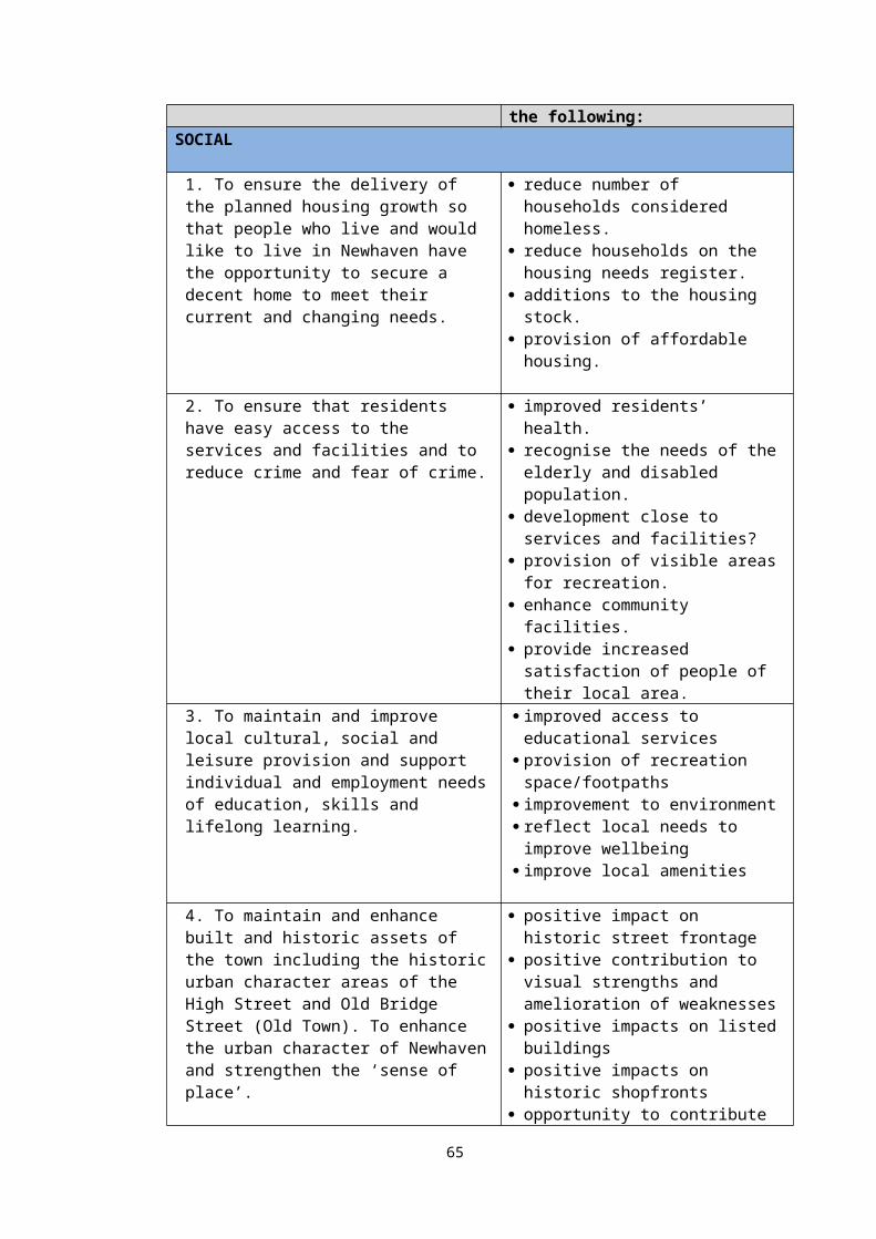
11 APPRAISAL OF ALTERNATIVE AND THE CUMULATIVE EFFECTS OF THE PLAN
11.1 The purpose of this report is to provide an assessment of any significant social,
environmental and economic effects resulting from the policies and proposals of the NNP
in accordance with EU Directive 2001/42 on strategic environmental assessment (“the
SEA”) and the Environmental Assessment of Plans & Programmes Regulations 2004
(“the EA Regulations”).
11.2 The Sustainability Appraisal (SA) seeks to address the wider sustainability objectives in
line with national guidance with the aim to achieving sustainable development as per the
National Planning Policy Framework.
11.3 The report seeks to undertake this wider assessment in a way that is proportionate to the
task and that recognises the limitations of the available data and means of measuring
direct and cumulative effects. In doing so, the SA/SEA must be proportionate and “does
not need to be done in any more detail … than is considered to be appropriate for the
content and level of detail in the Neighbourhood Plan” (National Planning Practice
Guidance ID:11-03121).
11.4 Throughout the development of the NP a number of modifications have been made to the
plan policies to reflect changes following consultation periods and time needed to finalise
policies. However, modifications to the SA/SEA only need to be considered where
appropriate and proportionate to the level of change being made to the Neighbourhood
Plan and the change is likely to be significant if it substantially alters the plan and/or is
likely to give rise to significant environmental effects (ID: 11-42). This SA/SEA Report is
considered to demonstrate that the NP, when taken as a whole, will achieve a significant
contribution to sustainable development.
11.5 Outlining the different approaches that could have been included in the plan as well as
different site options is an important part of the SA process. Analysing reasonable
alternatives demonstrates that the most sustainable options for the plan have been
identified. This part of the appraisal process considers different spatial strategies for the
plan, it then goes on to examine the effects on the sustainability of the area if a plan is not
“made”. This is the main alternative in terms of policy options for the plan. Finally, the
main sites that have been excluded from the Plan have been appraised. Appraising these
potential sites is, therefore, a reasonable alternative to those in the draft plan.
21 https://www.gov.uk/guidance/strategic-environmental-assessment-and-sustainability-appraisal
65
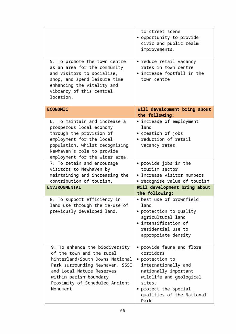
Alternative policy approach
11.6 The main reasonable alternative for the policies in the plan is the “do nothing scenario”;
that is the effect of the sustainability of the area if the Neighbourhood Plan is not in place.
Considering the effects of sustainability without the plan is also a requirement of the SEA
Directive.
11.7 Without the Neighbourhood Plan proposals for housing development, a vibrant town
centre and new employment floorspace with regeneration proposals, development in the
town would not be guided by the local community to ensure this can be achieved. Other
environmental assets, such as the setting of the National Park and the creation of Local
Green Space are also afforded greater protection from the Neighbourhood Plan.
Alternative sites
11.8 All sites submitted through the call for sites exercise were originally assessed against the
sustainability objectives.
Cumulative effects
11.9 Cumulatively the plan is likely to make a positive contribution to housing, economic
development, the town centre and the wider community. However, there are also likely to
be some cumulative negative effects such as increased surface water run off combined
with the existing flood zones and traffic generation with new housing development and
employment opportunities creating more car use.
11.10 A further potential impact from this spatial and site allocation approach is a cumulative
pressure on areas of open space or the potential effect on the landscape/setting of the
National park and heritage assets. However, given the clear protection policies in the
plan and the concentration of re-using existing brownfield sites, overall this effect is
unlikely to be a significant.
11.11 It is considered there will be no worsening of existing issues connected with the
environment and for a significant number (i.e. it is neutral in some aspects) will result in
positive impacts to the environment from the adoption and implementation of all the
66
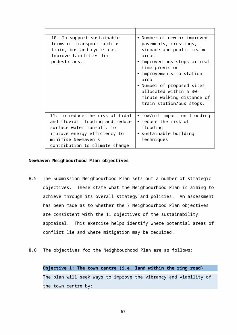
policies contained within the plan. This is the same for the impacts of new development of
the local community and the local economy.
11.12 SEA guidance requires measures to prevent, reduce or offset significant adverse effects
of implementing the plan. Where practical this report identifies the likely negative and
positive impacts each policy has on achieving sustainability objectives based on the
framework set out. It demonstrates that the policies of the NP will positively contribute
towards delivering the social, economic and environmental objectives set out in the SA
framework.
67
12 MITIGATING AND MONITORING
12.1 The SA has identified potential negative and positive effects arising from the plan.
Changes to the policies have been made as a result of the responses received at the
Regulation 14 stage. The final policies are now assessed in this SA. Appendix F lists the
policies in one table.
12.2 In addition to these specific changes, there are some general issues that have been
identified through the appraisal process. The plan is generally positive in terms of socio-
economic issues and certain environmental issues. Due to the significant need for
regeneration within the town, the Plan has sought to sufficiently address this through
focussing on identified locations where change can be made. The wide range of policies
focussing on protecting open space and creating new green areas as well as design and
urban enhancement has meant that mitigating the effects and impacts of new
development has been incorporated within the NNP.
12.3 The sustainability effect of the Neighbourhood Plan should be monitored for both its
positive and negative impacts. The most significant effects to be monitored will be in
terms of the provision of housing units constructed, impact on the
employment/social/community fabric of Newhaven, loss of open space/pressure from
development and traffic generation. Other impacts include flooding and effects on the
National Park.
12.4 Some monitoring measures are collected by Lewes District Council in its Authority
Monitoring Report as well as the South Downs National Park Authority. In other cases, the
Town Council will endeavour to collect data to report on the progress of the plan.
68
APPENDIX A
Checklist
69
SEA requirements and where they are addressed in SA Report
Requirements Where covered in the report
An outline of the contents, main objectives of the plan or programme, and relationships with other relevant plans and programmes.
Chapters 2,3 & 6, scoping report and Pre-Submission SA
The relevant aspects of the current state of the environment and the likely evolution thereof without implementation of the plan or programme
Chapter 5, scoping report and Pre-Submission SA
The environmental characteristics of areas likely to be significantly affected.
Chapter 5
Any existing environmental problems which are relevant to the plan or programme including, in particular, those relating to any areas of a particular environmental importance, such as areas designated pursuant to Directives 79/409/EEC and 92/43/EEC.
Chapter 7
The environmental protection objectives, established at international, community or national level, which are relevant to the plan or programme and the way those objectives and any environmental, considerations have been taken into account during its preparation.
Chapters 7 & 8
The likely significant effects on the environment, including on issues such as biodiversity, population, human health, fauna, flora, soil, water, air, climatic factors, material assets, cultural heritage including architectural and archaeological heritage, landscape and the interrelationship between the above factors. These effects should include secondary, cumulative, synergistic, short, medium and long-term, permanent and temporary, positive and negative.
Chapters 7 & 8
The measures envisaged to prevent, reduce and as fully as possible off-set any significant adverse effects on the environment of implementing the plan or programme.
Chapters 9 & 10
An outline of the reasons for selecting the alternatives dealt with, and a description of how the assessment was undertaken including any difficulties (such as technical deficiencies or lack of know-how) encountered in compiling the required information.
Chapters 9, 10 & 11
A description of measures envisaged concerning monitoring in accordance with Article 10.
Chapter 12
70
APPENDIX B
Responses to Scoping Report
71

Response to Scoping Report
Consultee Comments ResponseNatural England
16/10/2015
Section 2 – Background to Sustainability Appraisal1. We accept the conclusion that the Plan is unlikely to have a significant effect on Ashdown Forest SAC/SPA or the other international sites within its zone of influence (Castle Hill and Lewes Downs). We note that this section recognises that “Although the development target for the town has been appraised through the Lewes District Core Strategy SA/SEA, the precise location of sites was not known. The neighbourhood plan will allocate the sites and so likely significant environmental effects cannot be ruled out”. However, the same caveat should also apply to next section (g) “the effects on areas or landscapes which have a recognised national, Community or international protection status” as sites may also have the potential to impact on the special qualities of the South Downs National Park and/or its setting.
2. At this stage, yes. This may need reviewing when sites are allocated.
Section 3 – Town Portrait 3. Note that the entire Plan area is within the South Downs National Park itself or its impact risk zone 4. The Plan boundary contains many areas of priority (BAP) habitat outside the designated sites, notably coastal and floodplain grazing marsh, lowland calcareous grassland, maritime cliff and slope, coastal vegetated shingle,
The Town Council notes the points raised in terms of the potential impacts of any sites identified for development on the special qualities of areas of landscape value and this matter will be taken into account when assessing sites. There is a strong emphasis on developing brownfield land within the urban area and this will be taken forward through the SA and site assessment work.
We note the reference to the plan being within the National Park risk zone and will take this on board when considering sites.
Thank you for the reference to the coastal path network trail. The neighbourhood plan will consider a number of policy areas relating to access to the coast, recreation and tourism.
We have noted your comments on the minimizing impact on protected species and the Town Council would wish to ensure that policies included reference to securing opportunities to enhance biodiversity. The Town Council however, is unable to resource detailed biodiversity surveys for each site. However, advice will be sought from Natural England at East Sussex County Council on the preferred list of sites as part of the Sustainability Appraisal and site assessment work through the Reg 14 consultation. References to ensure there is no net loss together with securing new opportunities to improve biodiversity will be considered within neighbourhood plan policies.
72
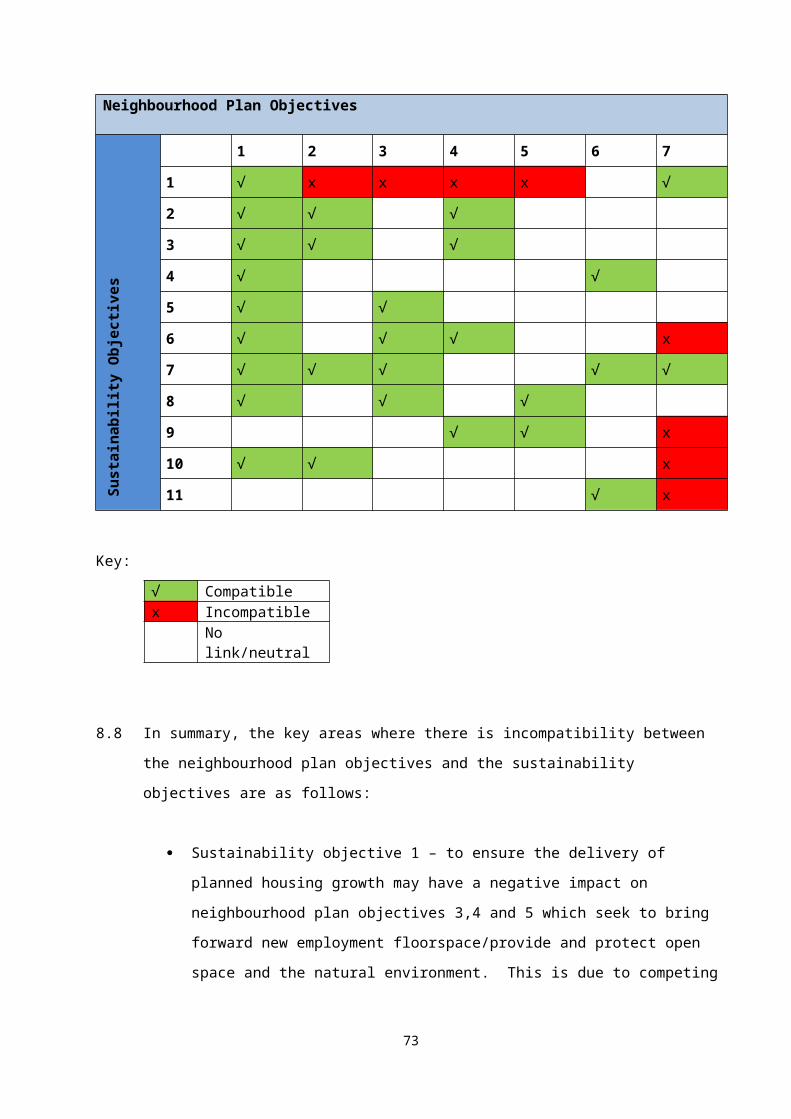
deciduous woodland, coastal saltmarsh, mudflats. The coast needs to be specifically referenced, particularly in light of the Coastal Path National Trail which will be implemented in this area in 2016-17. Local Planning Authorities must have regard to the NPPF which encourages improved public access to the coast and ensures new development does not hinder the creation of the Coastal Route. For more information, see https://www.gov.uk/government/publications/england-coast-path-overview-of-progress Section 5 – Sustainability Framework 8. We support the aspirations in #14 to (p11). This could also include a commitment to ensuring no net loss in priority habitat and minimising impact on protected species. To contribute towards the Government’s target to halt the decline in biodiversity (NPPF, Para 109), the plan should secure opportunities to enhance biodiversity. Objectives and Strategic Policies should aim for a net gain for nature. Development Management policies should promote the preservation, restoration and re-creation of priority habitats, ecological networks and the protection and recovery of priority species populations. Where it is known/likely that potential allocations are used by protected species, appropriate surveys be undertaken to inform the plan in respect of any constraints or requirement that may apply to development. Reference should also be made in the plan to the need for similar appropriate surveys of windfall sites, known/likely to be used by protected species, prior to determination of planning applications, to inform any
Thank you for the link to National Character Area information.
73
decision. Their protection should be one of the central considerations at the detailed planning stage and early reference to biological records would clarify where these issues may be acute. We look forward to seeing the draft plan in due course. Newhaven falls within the South Downs National Character Area. You may find it useful to refer to the profile while preparing the Plan:http://publications.naturalengland.org.uk/publication/7433354?category=587130 Due to the current pressure of consultations on land-use plans, I have not been able to spend the time I would have wished reviewing this document. Nevertheless, I hope you have found our comments helpful. If there are issues, I have not covered, please let me know and I will respond as quickly as possible. If discussion would be helpful, please contact me.
Environment Agency
16/11/15
Thank you for consulting us on your Neighbourhood Plan. The Environment Agency is a statutory consultee in the planning processproviding advice to Local Authorities and developers on pre-application enquiries, planning applications, appeals and strategic plans. In Section 5 Sustainability Framework, we are pleased to see that you have included objectives to protect and enhance the environment relating to the environmental constraints in your local area. We also recommend your SA takes account of relevant
Thank you for your comments which have been noted.
74
policies, plans and strategies including your local Strategic Flood Risk Assessment, flood risk strategies (https://www.gov.uk/government/collections/flood-risk-management-current-schemes-and-strategies), and the South East River Basin Management Plan (https://www.gov.uk/government/publications/south-east-river-basin-management-plan) Together with Natural England, English Heritage and Forestry Commission we have published joint advice on neighbourhood planning which sets out sources of environmental information and ideas on incorporating the environment into plans. This is available at:http://webarchive.nationalarchives.gov.uk/20140328084622/http://cdn.environment-agency.gov.uk/LIT_6524_7da381.pdf.
75
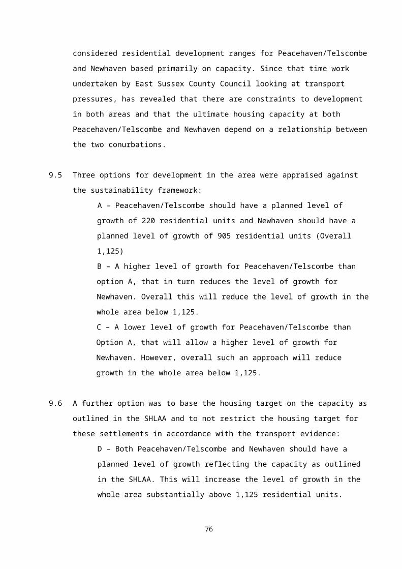
APPENDIX C
Relevant Plans and Programmes
76
Title DateInternational
European Landscape Convention 2004 European Strategy on Sustainable Development 2001 and
2009 Update
EU Seventh Environmental Action Plan to 2020 2013European Communities Directive on the Conservation of Wild Birds. Directive 2009/147/EC (this is the codified version of Directive 79/409/EEC as amended)
2009
EC Council Directive on the Conservation of Habitats and of Wild Fauna and Flora 92/43/EEC
1992
The Landfill Directive (1999/31/EC) 1999EU COM (2002) 581 final: Proposal for a Directive concerning the quality of bathing water
2002
EU Water Framework Directive (2000/60/EC) 2000EU Air Quality Directive - Ambient Air Quality and Cleaner Air for Europe 2008/50/EC
2008
NationalNational ‘Planning Practice Guidance’ (PPG) 2012National Planning Policy Framework 2012 &
2018Department of Health ‘White Paper - Healthy Lives, Healthy People’ 2010The Conservation of Habitats and Species Regulations 2010 (Chapter 8 covers Land Use Plans)
2010
Town and Country Planning Act 1990 1990Planning and Compulsory Purchase Acts 2004 and 2008 2004 &
2008DEFRA Sustainable Development Strategy ‘Foundations of our Future’ 2002DFT ‘Towards a Sustainable Transport System: Supporting economic Growth in a Low Carbon Economy’
2007
Planning (Listed Buildings and Conservation Areas) Act 1990White Paper Heritage Protection for the 21st Century 2007DCMS ‘The Historic Environment: A Force for Our Future’ 2001DEFRA ‘Future Water: The Government’s Water Strategy for England 2008ODPM ‘The Planning response to Climate Change: advice on better practice’
2004
DEFRA ‘Climate Change Act’ 2008The Air Quality (England) Regulations 2000 and 2002 Amendment 2000 &
2002DEFRA ‘Air Quality Strategy for England, Scotland, Wales and NI’ 2011DfT ‘Delivering a Sustainable Transport System’ 2008Wildlife and Countryside Act 1981 (as amended) 1981Biodiversity: UK Action Plan DEFRA Securing the future: delivering UK sustainable development strategy
2005
77
UK Climate Change Programme 2006Countryside and Rights of Way Act (CROW) 2000Making space for water Taking forward a new Government strategy for flood and coastal erosion risk management in England
2005
Safeguarding our soils: A Strategy for England Defra 2009The Flood and Water Management Act 2010 HMSO 2010Department for Transport Guidance on Accessibility Planning in Local Transport Plans
2004
Department for Transport Delivering a Sustainable Transport System 2008Department for Transport Active Travel Strategy 2010DEFRA Noise Policy Statement for England 2010Energy Act 2008DECC UK Renewable Energy Strategy 2009CLG & DfT ‘Manual for Streets 1 & 2’ 2007Environmental Protection Act 1990Ministry of State for Environment and Agri-Environment ‘Nottingham Declaration on Climate Change’
2000
Conservation (Natural Habitats &c) Regulations 2010Natural Environment and Rural Communities Act 2006DEFRA Natural Environment White Paper Defra 2011Air Quality Strategy for England, Scotland, Wales and Northern Ireland: Working Together for Clean Air
2011
CLG ‘Code for Sustainable Homes’: Setting the Sustainability Standards for New Homes and accompanying Technical Guidance - November 2010
2008 & 2010
Census Data 2001.Environment Agency mapping
Sub regional/DistrictLewes Air Quality Management Progress Report 2014Lewes District Council and South Downs National Park Authority, Landscape Capacity Study
2012
Lewes Employment Land Review 2010HRA Lewes Local Plan Part 2 with JCS Addendum 2017Strategic Housing Market Assessment LDC 2017Local Housing Needs Assessment LDC 2011Affordable Housing Needs Assessment LDC 2014Lewes Core Strategy Local Plan Part 1 2016Addendum to the Core Strategy Sustainability Appraisal Proposed Modifications
2017
Lewes District SFRA Main Report October 2009Strategic Housing and Economic Land Availability Assessment (SHELAA)
2018
Site allocations and development management policies 2018Lewes Local Plan Part 2 Sustainability Appraisal 2018 2018SE LEP Strategic Economic Plan 2017England Coast Path Shoreham-by-Sea to Eastbourne Natural England
78
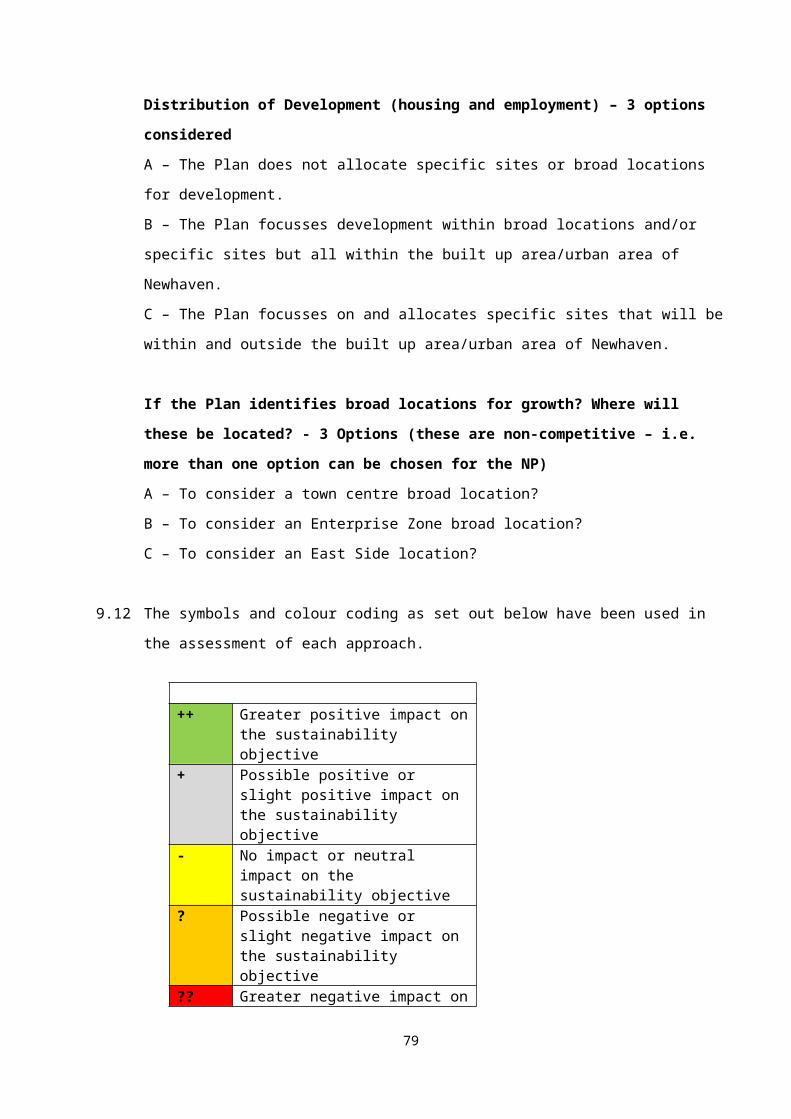
South Downs National Park Local Plan – Preferred Options 2015South Downs Local Plan – Submission 2018Partnership Management Plan: Shaping the Future of your South Downs National Park 2014-2019 (SNDP)SDNPA Water Cycle Study and Strategic Flood Risk Assessment 2015SDNPA Transport Study – Phase 1 Report 2013SDNPA Low Carbon and Renewable Energy Study 2012SDNPA Access Network and Accessible Natural Greenspace Study 2013SDNPA National Park Partnership Management Plan 2014-2019 2013SDNPA South Downs Integrated Landscape Character Assessment 2011Neighbouring Neighbourhood Plans
LocalNeighbourhood Plan Topic Papers 1-7 2014Town Centre Concept Masterplan and Options Study 2016Town Centre survey Report Newhaven 2015Newhaven Eastside Report 2006Newhaven Employment Land Review 2017Newhaven Transport Study 2011Newhaven neighbourhood Plan survey report 2014Newhaven Enterprise Zone Strategic Framework 2018A Profile of Newhaven – June 2014 2014Consultation Strategy – June 2014 2014Physical Development Vision for Newhaven 2008Peoples Report 2012Agendas and Meeting Notes of the Neighbourhood Plan Steering GroupNewhaven Air Quality Further Report 2014
79
APPENDIX D
Overall Policy Approaches
80
Table 1 Provision of Housing
Policy Approaches Sustainability Objectives Comment1 2 3 4 5 6 7 8 9 10 11
A – To deliver approximately 425 net additional dwellings within the Plan period on allocated sites.
++ - - + + ? - ++ ? + ? This approach considers the option to allocate sites that will deliver a certain number of houses. This will have a positive impact on SO 1 which seeks to deliver planned growth. It will also have a positive impact on SO 8 which relates to re-using developed land. Where this approach will have a slightly negative impact is on SO 6, 9 and 10. These relate to employment (in cases where employment land is allocated for housing), where sites maybe within or adjacent to protected areas and where sites are within flood zones or cause flooding. However, these matters all relate to where the sites are located and may not cause any negative impact once sites are selected. This is the preferred approach.
B – To not include a number for housing numbers within the Plan or allocate sites for development.
?? ? ? ? ? - - ?? - - - This approach considers the option of not allocating sites for housing or having a housing number. This could result in housing coming forward on sites that are not supported locally through the NP process. It is considered that this option has no positive impacts on the SO’s. It has a greater negative impact on SO1 which seeks to deliver planned housing growth. It has a slight negative impact on SO2,3,4,5 as it won’t enable funding and financial contributions through the development new housing to be spent on improving services, social and leisure infrastructure, the town centre and historic areas. It also won’t enable brownfield land to be developed.
81
Table 2 Provision and distribution of Employment Land
Policy Approaches Sustainability Objectives Comment1 2 3 4 5 6 7 8 9 10 11
A – To identify sites that can accommodate employment floor space and include a policy on retention of existing floorspace.
? - - - + ++ ++ ++ - - - This option relates to allocating sites that can accommodate a certain amount of new employment floorspace as well as retaining existing employment sites. This will have a greater positive impact on SO 6,7,8 as these relate to a prosperous economy, retaining jobs in the tourism sector and re-using brownfield land. It will have a slight negative impact on SO1 as it will reduce the amount of land available for housing. This is the preferred option.
B – To not include an allocation for new employment floor space within the neighbourhood plan
+ - - - ? ?? - ?? - - - This option relates to not including an allocation for employment space. This will have a greater negative impact on SO6 and 8 which refer to a prosperous economy and re-using brownfield land. It will also have a slight negative impact on SO5 which relates to the town centre but will have a slight positive impact on SO1 as it will allow more sites to be allocated for housing.
C – To only include a policy on preventing the loss of existing floorspace and no new allocations.
? - - - + ?? - ?? - - - This option is just for including a policy on retaining existing sites but no new allocations. AS above, it will have a greater negative impact on SO6 and 8 as it won’t enable new sites to be allocated for new and expanding businesses neither will it allow for the re-use of brownfield sites. It will have a slight negative impact on SO1 as it won’t free up old employment sites for new housing.
82
Table 3 Distribution of Development (housing and employment)
Policy Approaches Sustainability Objectives Comment1 2 3 4 5 6 7 8 9 10 11
A – The Plan does not allocate specific sites or broad locations for development.
?? ?? ? - ? ?? ? ?? - - - This option considers that no sites or locations for development are allocated. Whilst this is similar to some of the options in Tables 1 and 2 – it is to be assessed against other distribution of development options below. This scores greater negative impacts against SO1, 2, 6 and 7. This is because the option will not enable new housing, sites for new community facilities, employment sites or the re-use of brownfield land.
B – The Plan focusses development within broad locations and/or specific sites but all within the built up area/urban area of Newhaven22.
++ + + + + ++ - ++ ++ + - This option is to focus development on sites and locations solely within the urban area. It scores a greater positive impact on SO1, 6, 8 and 9. This is the opposite of the above option apart from SO9 which relates to protecting the rural hinterland. Whilst the option doesn’t outline specific protection proposals – it nevertheless offers protection from new development. Preferred option
C – The Plan focusses on and allocates specific sites that will be within and outside the built up area/urban area of Newhaven.
++ + + + + ++ - + ? ? - This option considers development both within the urban area and outside. It therefore has a slightly negative impact on SO9 which seeks to protect the rural areas. It hasn’t been scored as a greater negative impact as the selection of actual sites has not taken place and many will have no detrimental impact on protected areas. It also has a slight native impact on sustainable transport as some sites that are outside the urban area are located quite a distance away from central services.
22 Newhaven settlement boundary identified in Lewes Local Plan 2003
83
Table 4. If the Plan identifies broad locations for growth? Where will these be located? - 3 Options (these are non-competitive – i.e.
more than one option can be chosen for the NP)
Policy Approaches Sustainability Objectives Comment1 2 3 4 5 6 7 8 9 10 11
A – To consider a town centre broad location?
+ - + + ++ ? + ++ - ++ ? This policy approach considers the impacts of the town centre as a broad location for growth (both housing and employment development). It will have a greater positive impact on SO5 which is to promote the town centre. It will have a slight negative impact on flood risk (SO11) and SO6 on employment provision should sites allocated for employment be developed for housing. The town centre is identified as an Enterprise Zone and this needs to be considered when developing commercial sites for housing. In total, this approach contains negative impacts on two SO’s.
B – To consider an Enterprise Zone broad location?
?? - + - - ? + ++ - ++ ? This approach considers whether the Enterprise Zones (EZ) should be broad locations for growth. This scores as having a negative impact on SO 1, 6 and 11. The greater negative impact on SO1 relates to housing as the EZ are primarily for employment and business use. It will have a greater positive impact on SO8 and 10. In total this approach contains negative impacts on three SO’s.
C – To consider an East Side location?
? - + - - ? + ++ - ? ? This approach considers locating development on the East Side. This has a slightly negative impact on SO1, 6, 10 and 11. The reason for the impact on SO1 relates to the potential loss of some employment space to housing, for SO10 it relates to accessibility across the river to the town centre and services. This approach has a greater positive impact on SO8 as it enables sites for housing to be developed but this may negatively impact on SO6. In total this approach contains negative impacts on four SO’s.
84
APPENDIX E
Assessed Policies
85
Table Aa Policy TC1 - Regeneration of the Town CentreFinal policy in Submission NNP
1. A diverse range of retail and other uses within Newhaven Town Centre will be supported (those falling within retail use classes A1 A5, D1 non-residential institutions, D2 assembly and leisure and C1 hotels, boarding and guesthouses) and encouraged in order to support the retail, community and health hub functions of the area.2. Such uses will also be permitted in vacant retail units within the Newhaven Primary Shopping Area as indicated on Proposal Plan 1.3. Changes of use to residential and new residential development will be supported, except at street level in the Primary and Secondary Shopping Areas and at Primary and Secondary Frontages also on Proposal Plan 1 in order to support the vibrancy and vitality and increase footfall in the town centre.4. Applications for redevelopment within the town centre will be granted where proposals apply the following approaches:a) Any redevelopment of the town centre will need to have regard to the massing and character of buildings in the immediate vicinity and have regard to the design criteria as set out at Policy D1 (Chapter 7). Redevelopment of sites with residential, commercial, business and community use should contribute to an outward looking town centre environment by having visible active ground floor frontages onto the A259.b) Employment floorspace should form part of any development proposals which require the loss of existing employment provision in the primary and secondary shopping areas as identified at Proposal Plan 1, aiming for the desired uses identified in any implementation plan for the Enterprise Zone or range of uses appropriate for a retail and community hub.c) An appropriate level of car parking will need to be incorporated into any scheme that includes the removal of the existing multi-story car park in Dacre Road, to generate the same level of existing provision. Any loss of car parking will need to be justified through a car parking study.5. Proposals that seek to improve the public realm of the town centre such as new seating, signage, planting, new pavements and lighting will be supported. Measures to reduce the risk of surface water flooding will also be supported.
Options Obj 1 housing growth
Obj 2 access to services
Obj 3 social and leisure
Obj 4 heritage and urban
Obj 5 town centre
Obj 6local economy
Obj 7 visitors
Obj 8 brownfield land
Obj 9 biodiversity
Obj 10 sustainable transport
Obj 11 flood risk
A + ++ ++ ++ ++ ++ ++ ++ - - -B ?? ? ? ? ? ++ - - - - -C - + + + + + + ++ - - -Option A – To have a policy that supports the regeneration of the town centre and provides guidance on redevelopment proposals and sets out the primary and secondary shopping areas (existing policy). Option B – To have a policy that does not support any loss of retail unit and/or employment site within the town centre nor does it encourage the redevelopment of the town centre through other uses such as residential.Option C - To not have a policy and rely on the National Planning Policy Framework and strategic policies of the adopted Development Plan Document for the District
Appraisal: Option A scores as having a greater positive impact on a number of the sustainability objectives (SO) as it does encourage redevelopment and a diverse range of opportunities and facilities to serve the community including residential. This option scores highly against SO 2, 3, 4, 5, 6 and 8. There will be some restrictions on change of use within the primary and secondary shopping areas. Option B has a greater negative impact on SO 1 as it does not encourage residential through regeneration. It has a slight negative impact on SO 2, 3, 4 and 5 as it does not create urban regeneration opportunities due to the restrictive criteria on the loss of retail and employment. Option C scores as having a lesser positive impact on a number of SO as national and local district wide planning policies will support the revitalisation of town centres. However, these policies are not specifically focussed on Newhaven or in response from specific masterplan options produced by consultants for Newhaven town centre.
Preferred Policy Option: A
86
Table Ab Policy TC2 – Leisure Centre ProvisionFinal policy in Submission NNP
The Neighbourhood Plan supports the refurbishment or redevelopment of Seahaven Leisure Centre on the same site with any structural alterations or redevelopment featuring an outward facing active frontage onto the A259 ring road.
2. The replacement leisure facilities to be provided should not equate to any net loss of leisure facility floorspace compared to the existing facilities nor any reduction in the quality and range of facilities and the replacement facilities should be available for use prior to the closure of the existing facilities. The Town Council will require full consultation regarding the proposals with the local community.
Options Obj 1 housing growth
Obj 2 access to services
Obj 3 social and leisure
Obj 4 heritage and urban
Obj 5 town centre
Obj 6local economy
Obj 7 visitors
Obj 8 brownfield land
Obj 9 biodiversity
Obj 10 sustainable transport
Obj 11 flood risk
A - ++ + + ? - + - - - -B - ++ ++ ++ ++ - + + - - -C - ?? ?? + ? - ? + - - -D - + + + - - - - - - -Option A – To have a policy to demolish the existing leisure Centre and redevelop it on another site within Newhaven.Option B - To have a policy to refurbish the Leisure Centre on the existing site or to redevelop it on another site (existing policy).Option C – To have a policy to demolish the Leisure Centre but to not relocate or develop a new facility.Option D - To not have a policy and rely on the National Planning Policy Framework and strategic policies of the adopted Development Plan Document for the District.
Appraisal: The preferred option is B. This option has a greater positive impact on objectives 2, 3, 4 and 5. The option contains a number of possibilities to improve the leisure centre either by redeveloping it within the existing site or relocating it with Newhaven. This option also has a lesser positive impact on objectives 7 and 8. Redeveloping it on the existing site will enable the re-use of a brownfield site. A new facility may attract visitors to the town. Option A also involves a new leisure facility but the only option is to relocate it to a new site. Whilst a new site has not been found or referenced within this option, the proposal would have a greater positive impact on objective 2. It has only scored as having a lesser positive impact on objective 3 as a new site may not be accessible to all of the community depending on the location. It would also have a negative impact on the town centre if it was located some distance from there. Option C, which involves demolishing the existing leisure centre and not providing a replacement would have a greater negative impact on objectives 2 and 3. It would also have a negative impact on objectives 5 and 7. Finally option D would mean that there is a lesser positive impact on objectives 2, 3 and 4 as local and national policies would seek to protect and enhance leisure and recreational facilities however, these would not set out the detail required to bring forward a new or refurbished scheme in Newhaven but would merely seek to protect the existing.
Preferred Policy Option: B
87
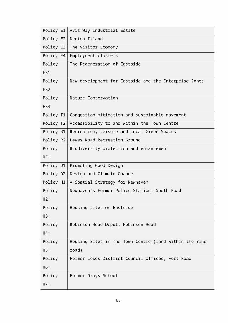
Table Ac Policy TC3 – High Street Design and Shop Fronts
Final policy in Submission NNP
1. The historic plot widths evident in the High Street, from its junction with Bridge Street at its eastern end, to South Way at its western end as indicated on Proposal Plan 2, should be replicated in any design approach for redevelopment of areas in the High Street. Where two shops or more become one, the design should include a representation of the original shop divisions.
2. Proposals for the alteration or construction of shop fronts in the High Street will be permitted, provided that the shop front is well proportioned and suited to the character of the building in which it is situated, through the use of appropriate materials, style, openings and size of windows and fascias and having regard to basic shop front components identified at Proposal Plan 3.
Options Obj 1 housing growth
Obj 2 access to services
Obj 3 social and leisure
Obj 4 heritage and urban
Obj 5 town centre
Obj 6local economy
Obj 7 visitors
Obj 8 brownfield land
Obj 9 biodiversity
Obj 10 sustainable transport
Obj 11 flood risk
A - - - ++ ++ + + - - - -B - - - + + + + - - - -Option A – To have a policy that focusses on the design of shop fronts and historic shop fronts in the High Street, Newhaven (existing policy).Option B - To not have a policy and rely on the National Planning Policy Framework and strategic policies of the adopted Development Plan Document for the District.
Appraisal: Option A is the preferred option as it relates to the specific historic nature of the High Street in Newhaven and seeks to ensure that the character of the area is preserved and enhanced through any redevelopment of the shop fronts. This option has a greater positive impact on objectives 4 and 5 and a lesser positive impact on objectives 6 and 7. Option B would still have a positive impact on these objectives but to a lesser extent than option A as the national and District wide policies will have a limited specific reference to Newhaven and to the characteristics of the town.
Preferred Policy Option: A
88
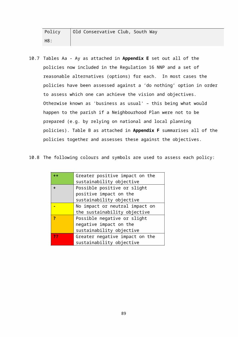
Table Ad Policy E1 – Avis Way Industrial Estate
Final policy in Submission NNP
Avis Way as shown on Proposal Plan 4 is allocated as a prime location for new and improved employment floor space. Retaining and improving key employment sites is a priority for the Neighbourhood Plan and reflects the Enterprise Zone designation.
2. Avis Way will be protected for a range of employment uses falling within Use Classes B1, B2 and B8. The Neighbourhood Plan supports a mix of employment floorspace including the provision of small and medium sized, flexible floorspace, start-up business space to support the town’s key employment sectors and retail.
3. Proposals to upgrade and refurbish existing office accommodation so that they meet modern standards required by business, are more resource efficient and improve the environment and townscape of the site or premises will be supported.
Options Obj 1 housing growth
Obj 2 access to services
Obj 3 social and leisure
Obj 4 heritage and urban
Obj 5 town centre
Obj 6local economy
Obj 7 visitors
Obj 8 brownfield land
Obj 9 biodiversity
Obj 10 sustainable transport
Obj 11 flood risk
A - - - - - ++ - ++ - - -B ++ - - - - + - ++ - - ?C + - - - - ++ - ++ - - -Option A –To have a policy that seeks to improve and retain Avis Way for employment uses (existing policy). Option B - To have a policy that seeks to retain employment uses plus appropriate residential/other uses.Option C - To not have a policy and rely on the National Planning Policy Framework and strategic policies of the adopted Development Plan Document for the District.
Appraisal: Option A relates to retaining the site as employment and Option B relates to enabling residential and other uses to come forward and to retain it as an employment site. Whilst this option appears to provide flexibility by supporting a range of uses, the preferred option depends on how the community see the future of the industrial estate. In a town like Newhaven, employment space is important and for an established estate like Avis Way – having a range of existing, new and improved employment sites is important. It is unlikely that residential would be appropriate in this area due to the presence of heavy and noisy commercial premises. Therefore, even though Option A was assessed originally as having a negative impact on SO1, there has been no objection to this policy in the Reg 14 version of the NP and it is therefore scored as having a neutral impact on SO1. Option C relates to District and local policies. There are no policies in the Lewes Core Strategy relating to Avis Way although there are general policies about protecting employment land.
Preferred Policy Option: A
89
Table Ae Policy E2 – Denton Island
Final policy in Submission NNP
On Denton Island (Proposal Plan 5) the Newhaven Enterprise Centre will be retained as an important location for small businesses. More prominent locations on the Island will include residential and enhanced business space. New areas of landscaping, planting and boundary treatment will be encouraged including a circular path around the island. Matters regarding land contamination will need to be addressed as part of proposed scheme for new development.
Options Obj 1 housing growth
Obj 2 access to services
Obj 3 social and leisure
Obj 4 heritage and urban
Obj 5 town centre
Obj 6local economy
Obj 7 visitors
Obj 8 brownfield land
Obj 9 biodiversity
Obj 10 sustainable transport
Obj 11 flood risk
A ++ - - - - ++ - ++ - - -B ++ - - - - ? - ++ - - -C + - - - - ++ - ++ - - -Option A –To have a policy that seeks to improve and redevelop Denton Island and retain the Newhaven Enterprise Centre (existing policy). Option B – To have a policy that seeks to re-locate the Newhaven Enterprise Centre in order to improve the offer of employment and residential on Denton Island. Option C - To not have a policy and rely on the National Planning Policy Framework and strategic policies of the adopted Development Plan Document for the District.
Appraisal: Both options A and B relate to retaining the Island for employment uses as well as including residential uses and improving the employment space. They both score as having a greater positive impact on objectives 1. All options previously scored as having a slight negative impact on objective 11 due to the location and the flood risk to Denton Island for residential use. However, with the Newhaven Flood Alleviations Scheme due for completion in 2019 and the policy not directly allocating a certain number of housing units for the site – the assessment now shows that there is a neutral impact on SO11 across all options. Option B involves the re-location of the Enterprise Centre and although this could be within Newhaven, the neighbourhood plan has not considered an alternative site. Therefore, option B scores as having a slight negative impact on objective 6 as it would result in the loss of some employment space on Denton Island. Option C relates to District and local policies. There are no policies in the Lewes Core Strategy relating to Denton Island although there are general policies about protecting employment land and supporting small and start-up businesses and improving employment floorspace as well supporting housing on brownfield land.
Preferred Policy Option: A
90
Table Af Policy E3 – The Visitor Economy
Final policy in Submission NNP
1. The Neighbourhood Plan supports the implementation of schemes that encourage tourism activity within Newhaven including:a) Café facilitiesb) Bike Hire Facilitiesc) Beach Huts for leisure and business used) New multi-purpose community centre at Lewes Road recreation grounde) Arts and Cultural centref) Artisans workshopsg) Clubhouse facilities for water craft by the riverh) Interpretation and visitor facilities at Newhaven Forti) Hotels and holiday rental accommodation
Options Obj 1 housing growth
Obj 2 access to services
Obj 3 social and leisure
Obj 4 heritage and urban
Obj 5 town centre
Obj 6local economy
Obj 7 visitors
Obj 8 brownfield land
Obj 9 biodiversity
Obj 10 sustainable transport
Obj 11 flood risk
A - - ++ ++ ++ ++ ++ - - - -B - - ++ ++ ++ ++ ++ - - - -Option A – To have a policy within the NNP that relates to the visitor economy and sets out a number of activities and locations the NP supports (existing policy)Option B - To not have a policy and rely on the National Planning Policy Framework and strategic policies of the adopted Development Plan Document for the District
Appraisal: Both options have the same impact on the objectives and have a greater positive impact on objectives 3, 4, 5, 6 and 7. There are a number of policies within the Lewes Core Strategy that relate to tourism including Core Policy 4, Core Policy 5, Core Policy 6 and Core Policy 8. However, the Core Strategy policies do not include a specific reference to activities and tourist locations as set out in the neighbourhood plan. This policy creates a local and community focus to a tourism policy.
Preferred Policy Option: A.
91
Table Ag Policy E4 – Employment Clusters
Final policy in Submission NNP
The Neighbourhood Plan seeks to retain the town’s key employment sectors and will support new development or improvement to existing facilities that enables them to stay and expand within the town. This includes:a) The Marine sector which is largely based at West Quay, land east of Robinson Road and Denton Island. Marine uses in these areas will be retained and loss of land or premises used by the marine sector will not be supported. New development on sites adjacent to the marine uses will need to take into account the needs and operations of the marine businesses. New uses will need to be able to coexist with the sector. b) Development within Use Class B1 that accelerates Newhaven’s transition to a new and higher value economic role including; high end manufacturing encompassing the ‘clean, green and marine’, creative and digital, advanced engineering, environmental technology and services and healthcare and biologics sectors will be supported.
Options Obj 1 housing growth
Obj 2 access to services
Obj 3 social and leisure
Obj 4 heritage and urban
Obj 5 town centre
Obj 6local economy
Obj 7 visitors
Obj 8 brownfield land
Obj 9 biodiversity
Obj 10 sustainable transport
Obj 11 flood risk
A - - - - - ++ - - - - -B - - - - - ++ - - - - -C - - - - - ++ - - - - -D - - - - - ++ - - - - -Option A – To have a policy within the supports the Marine sector and high end manufacturing sectors (existing policy).Option B – To have a policy that supports all high end/added value businesses regardless of sector.Option C – To have a policy that supports all types of businesses whether high end or not. Option D - To not have a policy and rely on the National Planning Policy Framework and strategic policies of the adopted Development Plan Document for the District.
Appraisal: All of these options relate to the local economy and therefore score as having a greater positive impact on objective 6. Regarding option D – Lewes Core Strategy Core Policy 4 refers to buoyant and balanced local economy so that the District doesn’t become reliant on one or two sectors. Whilst the NP policy includes only one sector and a wide ranging group of high end manufacturing, these are very relevant to Newhaven and supported by the community and in particular the marine sector should be retained within the current part of the town – this sector is part of the cultural heritage of Newhaven.
Preferred Policy Option: A
92
Table Ah Policy ES1 – The Regeneration of Eastside
Final policy in Submission NNP
In building on the current range of mixed uses at Eastside and enhancing the ‘sense of place’ new developments within the area identified at Proposals Plan 6 are expected to take into account:1. High quality design principles, ensuring that sustainable development is enshrined in development proposals for the Eastside. 2. Impacts on neighbouring uses as well as levels of parking and commercial traffic within residential areas. 3. New planting and landscaping as part of redevelopment and new development schemes especially along frontage areas where there is public access.4. New footpaths and links to bus stops and the railway station where possible to allow pedestrians a safe and pleasurable access to transport nodes. 5. Environmental quality and amenity with opportunities sought to enhance biodiversity and open, landscape and key employment clusters through development in the Enterprise Zone.6. The maintenance and improvement of existing surface water systems/drainage ditches.7. The location and design of residential development in regard to any noise or air quality issues from neighbouring port activity/industrial areas.
Options Obj 1 housing growth
Obj 2 access to services
Obj 3 social and leisure
Obj 4 heritage and urban
Obj 5 town centre
Obj 6local economy
Obj 7 visitors
Obj 8 brownfield land
Obj 9 biodiversity
Obj 10 sustainable transport
Obj 11 flood risk
A + + ++ ++ - + + ++ - ++ +B - - - - - ++ - ++ - + -Option A – To have a policy that supports the regeneration of Eastside to include a wide range of improvements and public realm projects (existing policy).Option B - To not have a policy and rely on the National Planning Policy Framework and strategic policies of the adopted Development Plan Document for the District
Appraisal: Option A originally score as having a slight negative impact on objective 1 as housing may not be appropriate is some parts of Eastside if there are heavy industry businesses nearby. However, this has been reassessed as having a slight positive impact on SO1. The policy specifically refers to taking the location of residential into account in terms of noise and air quality issues. In addition, the policy supports residential but as it does not contain specific allocated sites then if residential development does not come forward then it won’t have a detrimental impact on the delivery of the NP overall. Therefore, residential development will come forward as and when a suitable site is identified and in accordance with the policy. Option A has a positive impact on a number of objectives including objective 3 as the policy supports community uses and enhances the urban area (obj 4). It also has a positive impact on objectives 8 and 10. Eastside is mostly brownfield land and within a sustainable distance to the railway station, bus stops and areas of retail/shopping. Option B relies on District and national policies. There are no specific policies within the Lewes Core Strategy relating to Eastside but there are policies about protecting and enhancing areas of employment, brownfield land and sustainable transport.
Preferred Policy Option: A
93
Table Ai Policy ES2 New development for Eastside and the Enterprise Zones
Final policy in Submission NNP
1. The Eastside area of Newhaven as shown on Proposal Plan 6 is allocated as the prime location for new and improved employment floor space. Retaining and improving employment sites in Eastside will be a priority for the Neighbourhood Plan. The regeneration of Eastside will depend on a number of additional mixed and complementary uses coming forward on key sites including residential, leisure and tourism developments. 2. The Neighbourhood Plan supports a mix of employment floorspace (Use Classes B1, B8) including the provision of small and medium sized, flexible floorspace, move-on space for growing businesses and start up business space to support the town’s key employment sectors. Proposals to upgrade and refurbish existing office accommodation so that they meet modern standards required by business; are more resource efficient and safeguard or improve the environment and townscape of the site or premises will be supported. 3. To consolidate Newhaven’s tourism economy, proposals for hotel facilities will be supported at Eastside. 4. Leisure and recreation facilities will be supported in Eastside provided other policies within the Neighbourhood Plan, the Lewes District Joint Core Strategy 2016 and emerging South Downs Local Plan are considered such as parking and sustainable transport links, traffic generation and impact on neighbouring properties.5. New opportunities for food and drink outlets (Use Class A3) will be supported especially combined with leisure facilities in accordance with other neighbourhood plan policies and Lewes District Joint Core Strategy. 6. The Neighbourhood Plan supports up to 250 new residential units across the Eastside sites including the Enterprise zones. A viability/feasibility assessment report would need to accompany any planning application submitted that includes an element of residential development within an Enterprise Zone site to show that residential is an ‘enabler’ in order to bring forward modern commercial development and improvements to the sites. 7. Outside the Enterprise Zones as shown on Proposal Plan 6, residential development will be supported as part of mixed-use schemes provided the proposals comply with other policies within the neighbourhood plan and Lewes District Joint Core Strategy 2016. Sites within Eastside that could accommodate housing are set out in Policy H3.
Options Obj 1 housing growth
Obj 2 access to services
Obj 3 social and leisure
Obj 4 heritage and urban
Obj 5 town centre
Obj 6local economy
Obj 7 visitors
Obj 8 brownfield land
Obj 9 biodiversity
Obj 10 sustainable transport
Obj 11 flood risk
A ++ + + + - ++ + ++ - ++ -B ++ + + + - ++ + ++ - ++ -C ++ - - ? - + ? ++ - - -D ? - - - - ++ - ++ - - -Option A –To have an overarching policy that outlines support for a wide range of uses but with no specific sites identified for development (existing policy). Option B – To have a policy that supports redevelopment of sites for employment and residential mixed use to include leisure uses – each site (both inside and outside of the Enterprise Zones) to be identified together with the mix of uses and housing numbers.Option C – To have a policy that identifies sites for development that fall outside the Eastside Enterprise Zones only.Option D - To not have a policy and rely on the National Planning Policy Framework and strategic policies of the adopted Development Plan Document for the District
Appraisal: Options A and B have the same results and assessment ratings to each other. They both have a greater positive impact on Objective 1 (housing), Objective 6 (local economy) and Objective 10 (sustainable transport). The difference between the two options is that Option B seeks to identify each of the sites for development within the policy and to set down the exact mix of uses and housing numbers. In a large area such as Eastside where there are many existing businesses, brownfield sites and Enterprise Zone, it is not possible to identify all of the sites and set out the details for each. Both options were originally scored as
94

having a slight negative on Objective 5 as new retail units may impact on the town centre. However, the town centre policy has been enhanced and developed due to the work on the town centre masterplan and it is considered the options will have a neutral impact on the town centre. The options previously scored as having a slight negative impact on Objective 11 due to the flood risk to Eastside for residential use. However, with the Newhaven Flood Alleviations Scheme due for completion in 2019 and the policy not directly allocating a certain number of housing units for the site – the assessment now shows that there is a neutral impact on SO11 across all options. Option C relates to areas outside of the Enterprise Zones and this option scores as having a positive impact on Objective 1 as housing is likely to be supported on sites outside the Zones. However, this option does not provide an overall vision and strategy for all of Eastside and therefore has a slight negative on Objectives 4 and 7. Visitors will wish to visit Eastside if the entire area has been regenerated not just those locations outside of the Enterprise Zone. Option D will have a lesser negative impact on Objective 1 as there is no detailed District policy relating to the EZ sites or Eastside in terms of housing and therefore there is no certainty that these will come forward. District wide policies supporting the local economy and redeveloping brownfield land would support objectives 6 and 8. However, having a specific and detailed NP policy will be effective and provide an overall positive and spatial policy for the area.
Preferred Policy Option: A
95

Table Aj Policy ES3 - Nature Conservation
Final policy in Submission NNP
The natural environment of Eastside, including landscape assets, biodiversity, priority habitats and species and locally designated sites, will be conserved and enhanced by ensuring that new development will not harm nature conservation interests. In particular, the Ouse Estuary Nature Reserve identified at Proposal Plan 7 is to be protected from development and public access retained and enhanced where possible. New development within this area will need to consider the potential ecological impacts and will need to secure appropriate mitigation, compensation and enhancement.
Options Obj 1 housing growth
Obj 2 access to services
Obj 3 social and leisure
Obj 4 heritage and urban
Obj 5 town centre
Obj 6local economy
Obj 7 visitors
Obj 8 brownfield land
Obj 9 biodiversity
Obj 10 sustainable transport
Obj 11 flood risk
A - - ++ - - - - - ++ - -B ? - ++ - - ? - - + - -Option A –To have a policy that seeks to protect areas of nature conservation interest as part of any development plans for the Eastside (existing policy).Option B - To not have a policy and rely on the National Planning Policy Framework and strategic policies of the adopted Development Plan Document for the District
Appraisal: It is considered that both Options A and B have very similar impacts on the sustainability objectives. Whilst there isn’t a specific policy within National and District wide policies relating to Eastside, there are policies that cover protecting areas of nature conservation. However, the policy within the NP is specific to this part of Newhaven and therefore option B scores as only having a slight positive impact on objective 9. Options A and B will have a greater positive impact on objectives 3. The options were both originally assessed as having a slight negative impact on objectives 1 and 6 because through protecting areas of nature conservation value, this may limit the amount of housing and employment development coming forward. However, this policy is clear about how sites for employment and housing will need to take biodiversity into account.
Preferred Policy Option: A
96

Table Ak Policy T1 - Congestion mitigation and sustainable movement, including integrated footpaths and cycle-ways.
Final policy in Submission NNP
1. The Neighbourhood Plan seeks to improve sustainable movement throughout the town to reduce traffic impacts and support measures to improve air quality.2. Actions within new development which seek to minimise traffic impacts on the environment and improve air quality, including the provision of cycle storage, car sharing, and electric car charging points will be supported.3. Where possible, new development should encourage walking and cycling by the inclusion of pedestrian and cycle links to existing access network and areas of public access.4. New development will be expected to contribute towards the provision or improvement of cycle and pedestrian routes throughout and connections with the town to include links to the South Downs National Park, railway stations, bus stops and subway enhancements to encourage their use and improve cross town links. 5. Proposals which will lead to increased traffic flows or congestion must take proportionate steps through section 106 agreements or section 278 agreements under the Highways Act 1980 as appropriate, to mitigate traffic impacts of new development. Mitigation may include a range of approaches such as:a) Upgrading pedestrian crossing equipment including phasingb) Pedestrian and traffic signal enhancements (linking)c) Junction improvements6. To improve sustainable movement between the east and west sides of the town, a new mobile pedestrian/cycle bridge over the River Ouse of exemplary design will be supported.
Options Obj 1 housing growth
Obj 2 access to services
Obj 3 social and leisure
Obj 4 heritage and urban
Obj 5 town centre
Obj 6local economy
Obj 7 visitors
Obj 8 brownfield land
Obj 9 biodiversity
Obj 10 sustainable transport
Obj 11 flood risk
A - + ++ - ++ + + - - ++ -B - + + - - - - - - + -Option A –To have a policy that seeks to promote sustainable transport and links with new development sites and transport hubs and supports a new pedestrian/cycle bridge (existing policy) Option B - To not have a policy and rely on the National Planning Policy Framework and strategic policies of the adopted Development Plan Document for the District
Appraisal: Option A includes many of the policy statements that form national and District wide policies. However, it includes a reference to supporting a new bridge across the River Ouse to improve movement from one side of the town to the other. This option will have a greater positive impact on objectives 3, 5 and 10. It will also have a lesser positive impact on objectives 2, 6 and 7 as improvements to east/west movements will assist the local economy and access to services. Option B relies on national and District wide policies. These do support and promote sustainable transport but do not specifically outline schemes that directly improve Newhaven.
Preferred Policy Option: A
97

Table Al Policy T2 - Accessibility to and within the Town Centre
Final policy in Submission NNP
Proposals within the town centre which seek to improve accessibility and movement will be supported. All redevelopment will be expected to provide for or contribute towards:a) Improved accessibility and parking for the disabled and wheelchair and mobility scooter users.b) Improvements to the legibility and treatment of vehicle, pedestrian and cycle routes within the centre, including improved surfaces and signposting.c) Improvements to pedestrian and cycle linkages across the A259 into the predominantly residential areas to the south, west and north and towards the railway stations.
Options Obj 1 housing growth
Obj 2 access to services
Obj 3 social and leisure
Obj 4 heritage and urban
Obj 5 town centre
Obj 6local economy
Obj 7 visitors
Obj 8 brownfield land
Obj 9 biodiversity
Obj 10 sustainable transport
Obj 11 flood risk
A - ++ ++ - ++ - ++ - - ++ -B - + + - ++ - + - - - -Option A –To have a policy that seeks to improve accessibility to and within the town centre (existing policy) Option B - To not have a policy and rely on the National Planning Policy Framework and strategic policies of the adopted Development Plan Document for the District
Appraisal: Option A scores as having a greater positive impact on objectives 2, 3, 5, 7 and 10 in that it seeks to improve accessibility from the town centre to the pedestrian areas of the town. This proposal will have a substantial positive impact on local residents and their ability to access services and leisure/social facilities and the town centre. It will have a positive impact on visitors and providing space for pedestrians thus supporting sustainable transport. Whilst some of these issues are covered in national and local policies (option B), there is no specific reference to linkages across the A259.
Preferred Policy Option: A
98
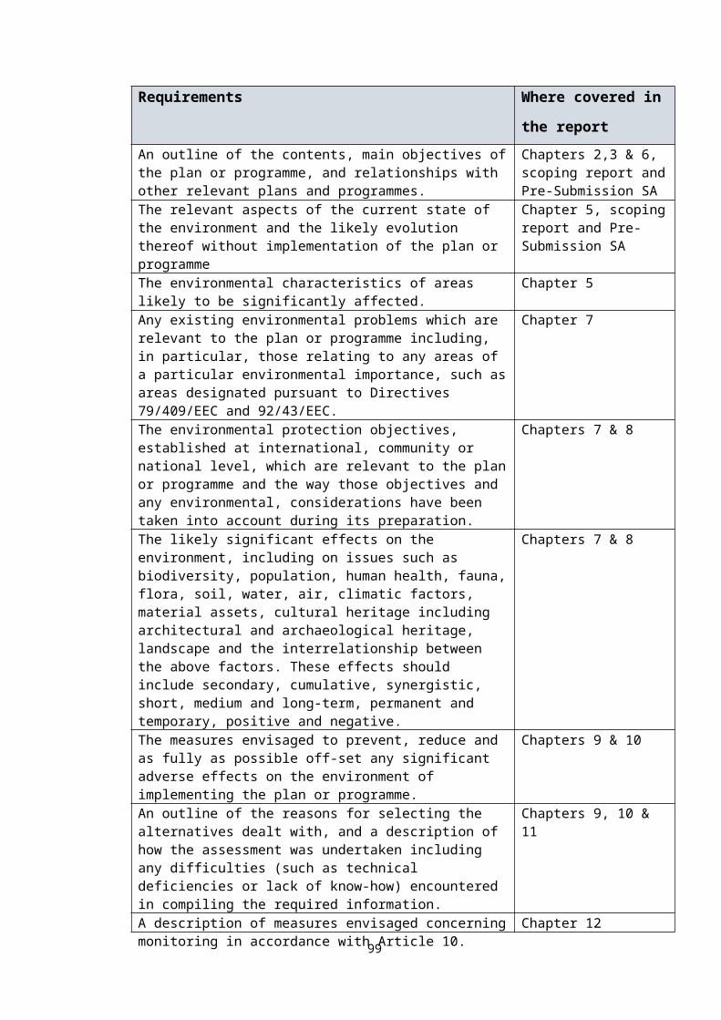
Table Am Policy R1 - Recreation, leisure and identified Local Green Spaces
Final policy in Submission NNP
1. New and improved quality formal and informal areas for recreation will be supported.2. Development proposals should take every opportunity to contribute to a connected recreational green network and provision of new open spaces/playing fields.3. Development which would result in the loss of existing areas of formal and informal recreation such as playing fields, amenity open spaces and allotments as listed below and identified on Proposal Plan 8 will not be permitted unless:a) An assessment has been undertaken which shows the facility to be surplus to the requirements of Newhaven residents.b) Alternative provision is made elsewhere within the parish area that is at least equivalent in terms of size and amount of facilities offered or would result in a net improvement in the quality of the facilities.Sites
1. Fort Road Recreation Ground2. Lewes Road Recreation Ground3. Eastside Recreation Ground4. Denton Recreation Ground5. Denton Cricket Ground6. Riverside Park7. Valley Road Play Area 8. Bay Vue Amenity Area9. Western Road Amenity Area
10. Huggetts Green11. West Quay Open Space12. Valley Ponds13. Drove Park14. Avis Road Open Space15. Bollens Bush16. Ouse Estuary Nature Reserve17. Eastside Allotments18. Lewes Road Allotments
4. New allotments will be supported within the area defined on Proposal Plan 12 (see Section 13), or near that area and be managed by a body such as the Town Council. Proposed land must be accessible by vehicles, have adequate off-street parking and have access to a water supply.5. The Neighbourhood Plan designates the following sites identified on the Proposal Plan 8 as Local Green Spaces.• Meeching Down (The Union), off Brighton Road• Castle Hill Nature ReserveOptions Obj 1
housing growth
Obj 2 access to services
Obj 3 social and leisure
Obj 4 heritage and urban
Obj 5 town centre
Obj 6local economy
Obj 7 visitors
Obj 8 brownfield land
Obj 9 biodiversity
Obj 10 sustainable transport
Obj 11 flood risk
A - - ++ + - - + - + - -B - - ? - - - - - + - -Option A – To have a policy that sets out the sites to be allocated as local green spaces and prevents the loss of areas for recreation (existing policy).Option B - To not have a policy and rely on the National Planning Policy Framework and strategic policies of the adopted Development Plan Document for the District
Appraisal: Option A is the culmination of extensive background research undertaken by the steering group. This policy has been assessed as having a greater positive impact on a number of objectives. The spaces have been assessed as being appropriate to include in the policy as judged against the criteria in the NPPF. In each case, the green spaces are an integral part of the town and are therefore regarded as special to the local community. Other sites were included in the initial trawl of suitable areas for allocation as local green spaces and these are included in the Local Green Spaces background document. The reason for rejecting some are set out in the document as they were not deemed to comply with the NPPF advice. Option B has been assessed as having a slight negative impact on objective 3. Whilst there could be an opportunity to include allocations for local green spaces within a review of the Lewes Local Plan, this is not guaranteed and it is unlikely a District wide document would include such allocations for each town. Therefore – without specific allocations within adopted development plans, there are no opportunities to protect these areas as green spaces of value to the local community.
Preferred Policy Option: A
99

Table An Policy R2 - Lewes Road Recreation Ground
Final policy in Submission NNP
1. The Neighbourhood Plan supports the development of a new community/visitor centre on land at Lewes Road Recreation Ground as shown on Proposal Plan 9, provided:a) The design of the facility provides flexible space to enable multi-purpose use if required to include bike/ hire, café, educational space and community use to serve the local community and visitors to riverside park area.b) Construction methods minimise energy and water use and the design promotes decentralised energy sources. c) The development can achieve satisfactory road access from Lewes Road and associated car and cycle parking.d) There is no significant harm to the countryside setting. 2. Improvements to ‘green’ linkages from Lewes Road recreation ground to the town centre and surrounding countryside will be supported to encourage residents and visitors walking and cycling to any new facility.
Options Obj 1 housing growth
Obj 2 access to services
Obj 3 social and leisure
Obj 4 heritage and urban
Obj 5 town centre
Obj 6local economy
Obj 7 visitors
Obj 8 brownfield land
Obj 9 biodiversity
Obj 10 sustainable transport
Obj 11 flood risk
A - + ++ - - - ++ - + ++ +B - + + - - - + - - + +C - - - - - - + - - + +Option A – To have a policy that supports a new community centre at Lewes Road Recreation ground (existing policy).Option B – To have a policy that supports a new community centre on another location within the town.Option D - To not have a policy and rely on the National Planning Policy Framework and strategic policies of the adopted Development Plan Document for the District.
Appraisal: Option A relates to a specific location which is set out in the policy and therefore can be accurately assessed against the objectives. This location for a community and visitor centre located within an existing country park is the result of consultation with the local community. Option B is more general and relates to the need for a community and visitor centre within the town but is not clear on the location. Therefore, it can only be assessed as having a lesser positive impact on objectives 2, 3 and 7. Option A has a greater positive impact on objectives 3, 7 and 10. The initial assessment found that Option A scored as having a slight negative impact on objective 8. However, there have been no objections to this policy during Reg 14 consultations and on balance, it is considered this particular use has been identified for this location and is not a development where many alternatives have been proposed or are suitable. There are no specific policies within District and National guidance on providing community centres in Newhaven but there is general support for facilities that provide the local community with access to the countryside.
Preferred Policy Option: A
100
Table Ao Policy NE1 - Biodiversity protection and enhancement
Final policy in Submission NNP
1. New development will seek to protect existing biodiversity assets including areas of priority in the Biodiversity Action Plan, notably; coastal and floodplain grazing marsh, lowland calcareous grassland, maritime cliff and slope, coastal vegetated shingle, deciduous woodland, coastal saltmarsh and mudflats, as well as statutory and non-statutory designations as identified on the biodiversity asset map at Proposal Plan 10 from any negative impacts. 2. Proposals that are likely to have a negative impact on biodiversity and habitats and species of principal importance should demonstrate how appropriate mitigation measures will be provided to rebalance any loss. New Development should avoid causing harm to the special qualities and setting of the National Park. 3. Proposals should also include actions that seek to enhance the ecological value of development sites by:a) the inclusion of enhanced or new biodiversity habitats, new green corridors, trees and hedges to allow the connectivity, passage and refuge of wildlife and the migration and transit of flora and fauna.b) planting species appropriate to the seaside and urban location and avoiding non-invasive species.c) the use of green (biodiverse) roofs should be promoted. Given Newhaven’s inclusion in the Biosphere, chalk grassland roofs are recommended.d) where appropriate by including ponds and wetland areas suitable for nature conservation and biodiversity enhancement, possibly as part of Sustainable Urban Drainage Systems.(Applicants are reminded to consult the biodiversity checklist on the Lewes District Council website before submitting a planning application for new development. Applicants will be encouraged to submit an Ecological Impact Assessment with their application).
Options Obj 1 housing growth
Obj 2 access to services
Obj 3 social and leisure
Obj 4 heritage and urban
Obj 5 town centre
Obj 6local economy
Obj 7 visitors
Obj 8 brownfield land
Obj 9 biodiversity
Obj 10 sustainable transport
Obj 11 flood risk
A - - - - - - - - ++ - -B - - - - - - - - ++ - -Option A – To have a policy that protects areas of biodiversity value (existing policy).Option B - To not have a policy and rely on the National Planning Policy Framework and strategic policies of the adopted Development Plan Document for the District.
Appraisal: Both Options score the same against the objectives. Options A and B score as having a greater positive impact on objective 9. National and District wide planning policies seek to protect areas of biodiversity value. The draft policy does make a small reference to Newhaven and it refers to the proposals map which identifies areas within the NP boundary. Therefore, on balance, option A provides a more local focus than District wide policies.
Preferred Policy Option: A
101
Table Ap Policy D1 – Promoting Good design
Final policy in Submission NNP
1. The development of sites or redevelopment of buildings fronting the A259 corridor in Newhaven should be of the highest quality design and construction quality, appropriate to its form and function. Higher residential densities in these locations are also supported. 2. Commercial premises adjacent to the ring road will have active frontages onto the road to signal the town centre location.3. Sculpture, installations and/or high-quality contemporary architecture innovative in design that is sustainable in its construction and operation will be encouraged at town centre gateways as shown on Proposal Plan 11 and other prominent locations.4. Development proposals are required to respond to the local surroundings, landscape and context as well as the built environment through: a) Making best use of the site;b) creation of a strong sense of place that relates well to surrounding development;c) Using good quality materials that complement the existing palette of materials used within the area; d) Using appropriate planting for highway boundaries wherever possible and in keeping with the existing streetscape; e) Ensuring safe access for pedestrians, cyclists and motorists; f) Providing adequate refuse and recycling storage incorporated into the scheme to minimise visual impact on the street scene;g) Ensuring that the design is compatible with deterring crime, including maximising opportunities for natural surveillance of public areas;h) Ensuring that the design of new residential development takes account of outside noise sources and mitigates against any material impacts of sound through building and layout orientation, provision of barriers and insulation;i) Providing a strong landscape framework, making the best use of existing trees and landscape features and providing soft and hard landscaping to enhance new development;j) Provision of green roofs on new commercial development where feasible to reduce the impact of large buildings when viewed from the surrounding National Park.
Options Obj 1 housing growth
Obj 2 access to services
Obj 3 social and leisure
Obj 4 heritage and urban
Obj 5 town centre
Obj 6local economy
Obj 7 visitors
Obj 8 brownfield land
Obj 9 biodiversity
Obj 10 sustainable transport
Obj 11 flood risk
A - + - ++ ++ + + - + + +B - - - - - - - - - - -Option A – To have a policy that sets out a range of design principles to ensure design is in keeping with the character of the surrounding area and sets out criteria for other matters such as lighting, landscape and public art and promotes sustainable development (existing policy). Option B – To not have a policy and rely on the National Planning Policy Framework and strategic policies of the adopted Development Plan.
Appraisal: Both options would ensure design is given due consideration. However, Option A seeks to ensure development is sympathetic and in keeping with the local area which will have a positive impact on sustainability objectives 2, 4, 5, 6, 7, 9, 10 and 11. It will provide greater detail on the characteristics of the NP area and the standards the community wish to see in all new development. Option B would not provide local context or local character and because of the wide ranging of issues this policy covers, it is not possible to highlight any particular objective that Option B supports positively. In effect all of the issues are covered to some extent by local and national policies but they are no brought together in a coherent locally focussed policy such as that drafted in the NP.
Preferred Policy Option: A
102
Table Aq - Policy D2 – Design and Climate Change
Final policy in Submission NNP
1. All new development within Newhaven should seek to achieve high standards of sustainable development and demonstrate in proposals how design, construction and operation has sought to:• Reduce the use of fossil fuels.• Promote the use of natural resources, the re-use and recycling of resources and the production and consumption of renewable energy.• Adopt and facilitate the flexible development of low and zero carbon energy through a range of technologies.• Adopt best practice in sustainable urban drainage (incorporating Sustainable Urban Drainage Systems).• Link the provision of low and zero carbon energy/heat infrastructure in new developments and where possible, to existing buildings.2. Residential, retail and employment development should provide accessible electric vehicle charging points (EVCP) in accordance with Lewes District Council’s EVCP Technical Guidance Note.3. Development will be expected to demonstrate how it is resilient to longer term impacts of climate change.
Options Obj 1 housing growth
Obj 2 access to services
Obj 3 social and leisure
Obj 4 heritage and urban
Obj 5 town centre
Obj 6local economy
Obj 7 visitors
Obj 8 brownfield land
Obj 9 biodiversity
Obj 10 sustainable transport
Obj 11 flood risk
A - + - ++ ++ + + - + + +B - - - - - - - - - - -Option A – To take a proactive approach by having a policy that sets out a range of design principles to achieve high standards of sustainable development to mitigate against and adapt to climate change (existing policy). Option B – To not have a policy and rely on the National Planning Policy Framework and strategic policies of the adopted Development Plan.
Appraisal: Both options would ensure design and climate change is given due consideration. However, Option A seeks to ensure development addresses a wide range of climate change issues and has a positive impact on sustainability objectives 2, 4, 5, 6, 7, 9, 10 and 11. It will provide greater detail on the characteristics of the NP area and the standards the community wish to see in all new development. Option B would not provide local context and because of the wide ranging of issues this policy covers, it is not possible to highlight any particular objective that Option B supports positively. In effect all of the issues are covered to some extent by local and national policies but they are not brought together in a coherent locally focussed policy such as that outlined in the NP.
Preferred Policy Option: A
103
Table Ar Policy H1 - A Spatial Strategy for Newhaven
Final policy in Submission NNP
1. In the period up to 2030, the spatial strategy of this Plan seeks to focus proposals for new residential and economic development within the existing built-up area of Newhaven as shown on Proposal Plan 12 (referred to as the development boundary). Within the development boundary proposals for new development will be supported, where they accord with other policies in the Neighbourhood Plan and other relevant development plan policies.2. Outside of the development boundary, priority must be given to protecting the countryside from development unless the proposal is essential to meet a necessary local-community facility need. Any such development must:a) Have no adverse impact on the rural character and natural beauty of the area, including the South Downs National Park:b) Have no adverse impact on biodiversity and wildlife habitats, c) Adopt best practice in sustainable building techniques.d) Be in accordance with other policies in the plan.
Options Obj 1 housing growth
Obj 2 access to services
Obj 3 social and leisure
Obj 4 heritage and urban
Obj 5 town centre
Obj 6local economy
Obj 7 visitors
Obj 8 brownfield land
Obj 9 biodiversity
Obj 10 sustainable transport
Obj 11 flood risk
A ++ - - + ++ ++ - + + - -B ++ - - + ++ ++ - + + - -C + - - - + + - - - - -Option A – To have a policy which states that only development proposals within the development boundary will be supported.Option B – To have a policy which states that development within the boundary will be supported but also states how development outside the boundary will be considered (existing policy).Option C – To not have a policy and rely on the National Planning Policy Framework and strategic policies of the adopted Development Plan.
Appraisal: The SA has already considered a number of spatial development options for the NP. This assessment considers the options for the actual policy. Option A has a positive impact on objectives 1, 4, 5, 6, 8 and 9. Whilst in theory Options A and B are similar in that the focus is on brownfield land – Option B provides clarity regarding what is acceptable outside of the development boundary. Whilst national and district wide policies do focus on development within development boundaries/protecting the countryside/developing brownfield sites/urban regeneration – these will be outlined within various and numerous policies and policy documents. Several policies within the Lewes Core Strategy will relate to Newhaven but not all. Therefore, this NP policy consolidates the priorities for Newhaven and confirms that all development and allocations within the NP are within the built up area boundary. The inclusion of the criteria relating to development within the countryside was as a result of the SA assessment at Reg 14 stage.
Preferred Policy Option: B
104
Table As Policy H2 – Newhaven’s Former Police Station, South Road
Final policy in Submission NNP
Land at Newhaven’s former police station as defined by Proposal Plan 13 is allocated for a minimum of 18 dwellings, subject to:a) the compliance with other policies within the Newhaven Neighbourhood Plan and the Lewes District Joint Core Strategy; andb) the following sites specific requirements;• the form, height and massing of any part of the development fronting South Road should reflect those of residential properties adjacent. A 2 or 3 storey building may be acceptable. • the residential units on this prominent site positively contributing to the street scene, creating interest and variety through a positive street frontage, distinctive massing and soft landscaping. • provision being made for the storage of cycles and bins for use by occupiers of the residential units.• Car parking for the residential development needs to be provided in accordance with East Sussex County Council parking standards. Where reduced car parking is sought, developer contributions are required to include a financial contribution towards car club infrastructure such as car club parking bays and other car club enabling measures, such as membership subsidy.c) Development of this site for sheltered housing is supported.Note: Affordable Housing should be provided in accordance with Lewes District Councils Affordable Housing Supplementary Planning Document July 2018. Proposals should have regard to Lewes Districts Joint Core Strategy Core Policy 2 – Housing Type, Mix and Density.
Policy H2 Obj 1 housing growth
Obj 2 access to services
Obj 3 social and leisure
Obj 4 heritage and urban
Obj 5 town centre
Obj 6local economy
Obj 7 visitors
Obj 8 brownfield land
Obj 9 biodiversity
Obj 10 sustainable transport
Obj 11 flood risk
++ - - + + - - ++ - ++ -
There is no assessment of alternative options against this policy as the preferred housing site has already been assessed against the sustainability objectives. However, the policy as written is now assessed against the objectives.
Recommend: To agree this is a policy that supports the sustainable objectives.
105
Table At Policy H3 - Housing sites on Eastside
Final policy in Submission NNP
The neighbourhood plan supports new housing as part of mixed-use developments on Eastside defined by Proposal Plan 14. This area can accommodate a minimum of 250 new dwellings. The following sites are allocated for new housing:a. Seahaven Caravans (minimum 22 dwellings)b. Land East of Reprodux House (80 dwellings) c. Bevan Funnell site (minimum 60 dwellings)d. Beach Road (minimum 60 dwellings) e. Land at Clinton Road, west of Railway Road (minimum 28 dwellings)Proposed development for each site needs to take the following into account: 1. Employment uses (class B1/B2/B8) are to be retained/new space provided on all sites apart from Seahaven Caravans. The exact type of floor area of employment to be agreed with Lewes District Council. 2. The design of new residential units are to be orientated within each site in order that future residents are protected from excessive noise and pollution from existing neighbouring businesses. 3. Parking is to be provided within the site boundary in accordance with East Sussex County Council parking standards. Where reduced car parking is sought, developer contributions are required to include a financial contribution towards car club infrastructure such as car club parking bays and other car club enabling measures, such as membership subsidy.4. The residential units positively contribute to the street scene using height and interest such as including elements of soft landscaping, integrated with the residential building/s.5. Any proposal must make provision for the storage of cycles and bins for use by occupiers of the residential units.6. Details setting out a landscaping scheme (to include hard and soft landscaping) will be submitted with each planning application.7. Any site within existing Flood Zone 2 and 3 shall include a site Flood Risk assessment with each planning application and consider the Neighbourhood Plan sequential test. 8. New footpaths/pedestrian and cycle routes linking the site to existing footpaths or routes to the town centre and/or National park will be encouraged.9. Where relevant, any application must include a land contamination report.Note: Affordable Housing should be provided in accordance with Lewes District Councils Affordable Housing Supplementary Planning Document July 2018. Proposals should have regard to Lewes Districts Joint Core Strategy Core Policy 2 – Housing Type, Mix and Density.
Options Obj 1 housing growth
Obj 2 access to services
Obj 3 social and leisure
Obj 4 heritage and urban
Obj 5 town centre
Obj 6local economy
Obj 7 visitors
Obj 8 brownfield land
Obj 9 biodiversity
Obj 10 sustainable transport
Obj 11 flood risk
A ++ - - ++ - ++ - ++ - ++ ++B ?? - - + - ++ - ++ - - -C + - - ++ - ++ - ++ - - ?D + - - ++ - ++ - ++ - - ?Option A – To have a policy that outlines possible housing sites and an overall figure for housing yield together with supporting employment and sustainable transport links/good design (existing policy). Option B – To have a policy that does not support housing on Eastside and focusses on employment development and growth.Option C – To have a policy that supports housing as well as employment but provides no indication on appropriate sites and/or provides no housing yield figure that can contribute towards the overall housing need for NewhavenOption D – To not have a policy and rely on the National Planning Policy Framework and strategic policies of the adopted Development Plan.
106
Appraisal: Option A provides certainty to the regeneration of Eastside by outlining sites for housing and employment development which will provide new opportunities to enhance this part of Newhaven. This option has a positive impact on objectives 1, 4, 6,8, 10 and 11. Option B has a negative impact on objective 1 as it does not support housing at Eastside. Whilst this option still has a positive impact on objective 6, it does mean that housing site will need to be found in other parts of Newhaven. In addition, this option will have limited positive impact on the regeneration of this urban area of the town (objective 4). It would still result in the development of brownfield sites. Option C does support housing at Eastside but provides no detail on where or the overall yield. Therefore, it only has a minor positive impact on objective 1 as there is no certainty that sites will come forward or are deliverable. It will also have a slight negative impact on objective 11. As sites are unknown then they won’t have been assessed through the NP sequential test. Whilst national and district wide policies do focus on regeneration of brownfield sites and mixed use development/urban design and sustainable transport – these will be outlined within various and numerous policies and policy documents. Several policies within the Lewes Core Strategy will relate to Newhaven but not all. Therefore, this NP policy consolidates the priorities for Newhaven and confirms where and what level of development is appropriate for Eastside.
Preferred Policy Option: A
107
Table Au Policy H4 – Robinson Road Depot, Robinson Road
Final policy in Submission NNP
Land as defined by Proposal Plan 15 is allocated for mixed use to provide a minimum of 40 residential units and 600m2 of employment floor space falling within Class B1, subject to:a) the compliance with other policies within the Newhaven Neighbourhood Plan and the Lewes District Joint Core Strategy; andb) the following site-specific requirements;• The removal of all existing buildings and restoration of all contaminated areas.• The units respond to the riverside setting and prominent location through exemplary design, the use of balconies or terraces to break up any massing to support delivery of a landmark building and key focal point.• Provision being made for the storage of cycles and bins for use by occupiers of the residential units.• Development integrating a pedestrian/cycle path linking Robinson Road to North Way to encourage access to the countryside and accessibility to town centre.• A site-specific Flood Risk Assessment to be submitted with any planning application with attention to floor levels, access, egress, safe refuge and flood protection scheme.• A transport statement to be submitted with ay planning application. Note: Affordable Housing should be provided in accordance with Lewes District Councils Affordable Housing Supplementary Planning Document July 2018. Proposals should have regard to Lewes Districts Joint Core Strategy Core Policy 2 – Housing Type, Mix and Density
Policy H4 Obj 1 housing growth
Obj 2 access to services
Obj 3 social and leisure
Obj 4 heritage and urban
Obj 5 town centre
Obj 6local economy
Obj 7 visitors
Obj 8 brownfield land
Obj 9 biodiversity
Obj 10 sustainable transport
Obj 11 flood risk
++ - - ++ + - - ++ - ++ ++
There is no assessment of alternative options against this policy as the preferred housing site has already been assessed against the sustainability objectives. However, the policy as written is now assessed against the objectives.
Recommend: To agree this is a policy that supports the sustainable objectives.
108
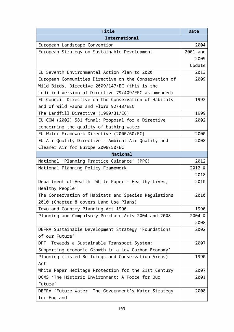
Table Av Policy H5: Housing Sites in the Town Centre (land within the ring road)Final policy in Submission NNP
1. The Neighbourhood Plan supports new housing as part of mixed-use redevelopment schemes within the town centre as defined by Proposal Plan 16, subject to the proposal following other policies within the Newhaven Neighbourhood Plan and the Lewes District Joint Core Strategy. In total the following sites can accommodate a minimum of 110 new dwellings at the following locations: a) Lower Place Car Park, North Laneb) Multi-Storey Car Park, Dacre Roadc) Co-op Building, Newhaven Squared) Seahaven Swimming Pool2. Development for residential development within the town centre needs to integrate the following approaches:i. New buildings respond to the prominent location of these sites on the A259 through exemplary design including welcoming pedestrian gateways and landmark architecture to help deliver a positive image of the town centre.ii. Redevelopment to take advantage of improving the public realm and green infrastructure, through the provision of green spaces, seating and an attractive mix of hard and soft landscaping including vertical horticulture and roof top gardens.iii. Provision is made for the storage of cycles and bins for use by occupiers of the residential units.iv. Car parking for the residential development needs to be provided in accordance with East Sussex County Council parking standards. Where reduced car parking is sought developer contributions are required to include a financial contribution towards car club infrastructure such as car club parking bays and other car club enabling measures, such as membership subsidy.3. Development of sheltered housing is supported within the town centre.Note: Affordable Housing should be provided in accordance with Lewes District Councils Affordable Housing Supplementary Planning Document July 2018. Proposals should have regard to Lewes Districts Joint Core Strategy Core Policy 2 – Housing Type, Mix and Density.Options Obj 1
housing growth
Obj 2 access to services
Obj 3 social and leisure
Obj 4 heritage and urban
Obj 5 town centre
Obj 6local economy
Obj 7 visitors
Obj 8 brownfield land
Obj 9 biodiversity
Obj 10 sustainable transport
Obj 11 flood risk
A ++ - - ++ ++ + + ++ - ++ -B + - - ++ ? + - ++ - - -C ? - - ++ + + - - - - -Option A – To have a policy that outlines possible housing sites and an overall figure for housing yield together with urban design/public realm improvements supporting employment and sustainable transport links/good design (existing policy). Option B – To have a policy that supports housing but provides no indication on appropriate sites and/or provides no housing yield figure that can contribute towards the overall housing need for NewhavenOption C – To not have a policy and rely on the National Planning Policy Framework and strategic policies of the adopted Development Plan.
Appraisal: Option A provides certainty for the town centre – setting out the proposed sites for development and an overall housing yield. This option has a positive impact on objectives 1, 4, 5, 6, 8 and 10. A separate policy within the NP focuses on the future of the swimming pool site. The policy includes sites that have been assessed through the SA process. Option B does not identify sites and therefor there is less certainty as to whether sites will come forward (objective 1). Due to this uncertainty, it may result in sites in retail use that form an integral part of the town centre function will come forward (objective 5). Whilst national and district wide policies do focus on regeneration of town centres - these will be outlined within various and numerous policies and policy documents. Several policies within the Lewes Core Strategy will relate to Newhaven town centre but as this is such an important part of the town and has an identified need for modernising and redeveloping, the NP policy consolidates the priorities for Newhaven town centre and confirms where and what level of development is appropriate for the area. Therefore, without a policy encouraging housing within the centre that will vitalise the area then option C has a slight negative impact on objective 1.
Preferred Policy Option: A
109
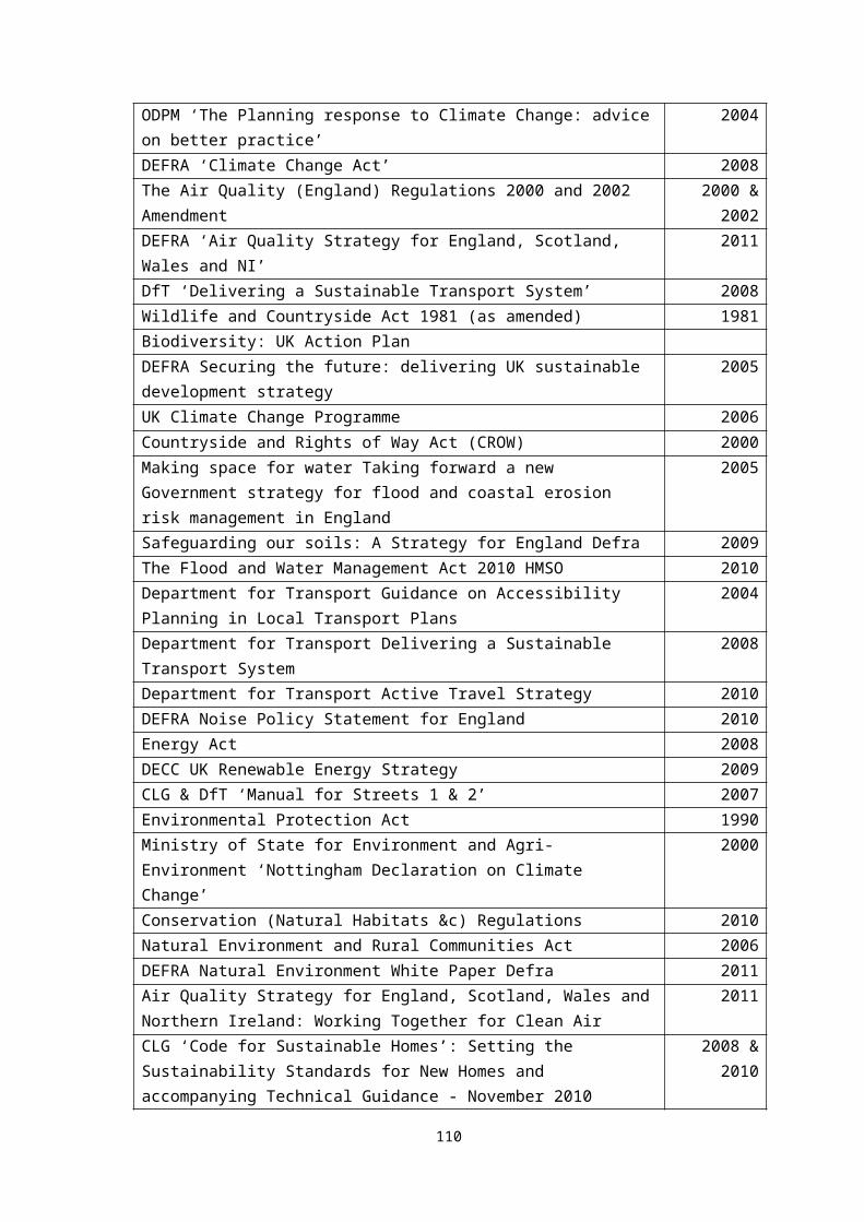
Table Aw Policy H6 – Former Lewes District Council Offices, Fort Road
Final policy in Submission NNP
Land as defined by Proposal Plan 17 is allocated for a minimum of 8 residential units, subject to:a) the compliance with other policies within the Newhaven Neighbourhood Plan and the Lewes District Joint Core Strategy; andb) the following site-specific requirements;• Redevelopment of the site should respect the surrounding scale and be of fine grain massing, to ensure compatibility with the existing street character.
Note: Affordable Housing should be provided in accordance with Lewes District Councils Affordable Housing Supplementary Planning Document July 2018. Proposals should have regard to Lewes Districts Joint Core Strategy Core Policy 2 – Housing Type, Mix and Density.
Policy H6 Obj 1 housing growth
Obj 2 access to services
Obj 3 social and leisure
Obj 4 heritage and urban
Obj 5 town centre
Obj 6local economy
Obj 7 visitors
Obj 8 brownfield land
Obj 9 biodiversity
Obj 10 sustainable transport
Obj 11 flood risk
++ - - ++ - - - ++ - - -
There is no assessment of alternative options against this policy as the preferred housing site has already been assessed against the sustainability objectives. However, the policy as written is now assessed against the objectives.
Recommend: To agree this is a policy that supports the sustainable objectives.
110
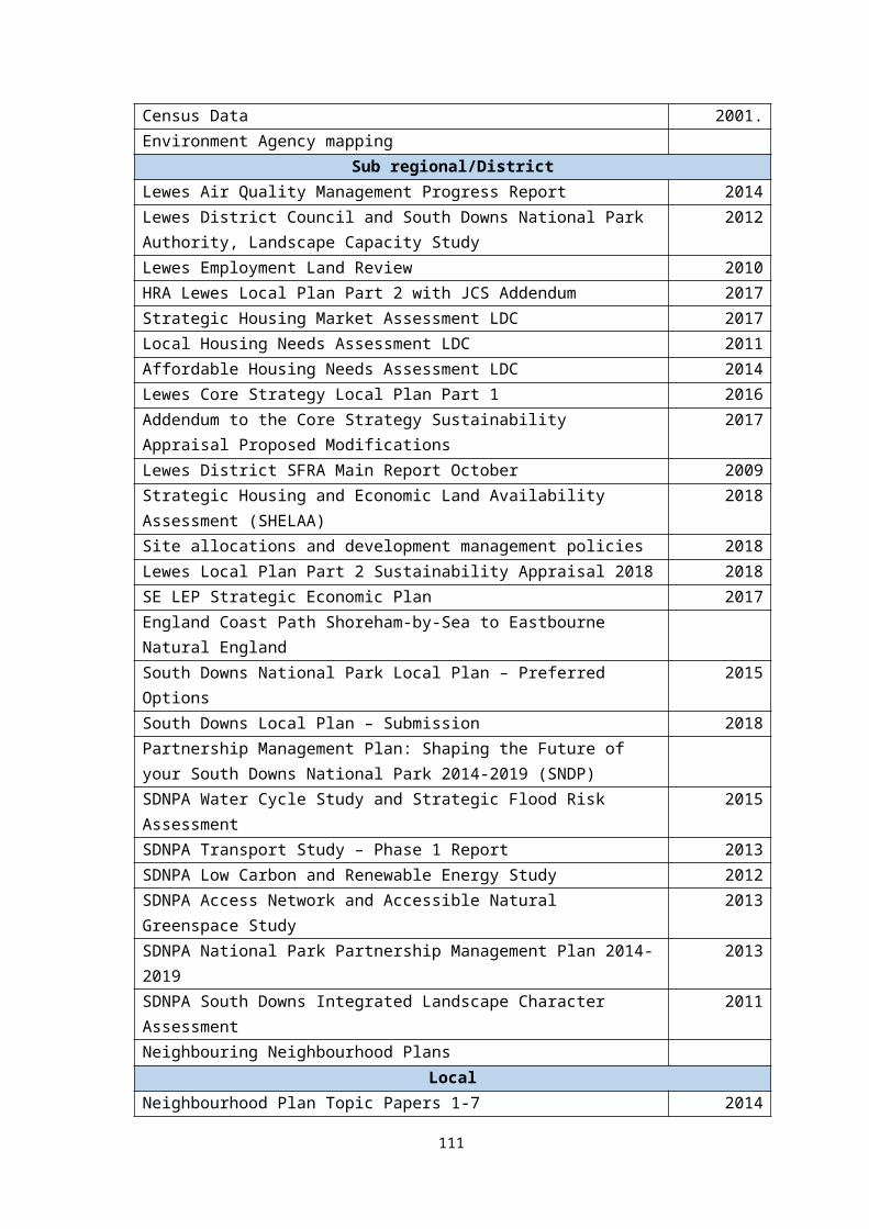
Table Ax Policy H7 – Former Grays School
Final policy in Submission NNP
Land at Grays School defined by Proposal Plan 18, is allocated for 27 dwellings:a) the compliance with other policies within the Newhaven Neighbourhood Plan and the Lewes District Joint Core Strategy; andb) the following site-specific requirements;• Submission of site layout drawing should include details of all trees on site, with a stem diameter of 100mm or greater. Drawings should include the crown spread of these trees.• An ecological survey of the site should be submitted as part of any planning application, including an assessment of the impact of the development on biodiversity and details of measures to alleviate any loss.• Development must produce a positive street frontage with outward facing properties overlooking existing streets.• Existing pedestrian accesses would need to be closed off and metal railings within the highway removed. New parking controls on Western Road (in place of the existing school keep clear markings) are required. Other required highway works include widening of the footway around the site to 2 metres together with dropped kerbs and/or tactile paving.
Policy H7 Obj 1 housing growth
Obj 2 access to services
Obj 3 social and leisure
Obj 4 heritage and urban
Obj 5 town centre
Obj 6local economy
Obj 7 visitors
Obj 8 brownfield land
Obj 9 biodiversity
Obj 10 sustainable transport
Obj 11 flood risk
++ - - ++ - - - ++ ++ - -
There is no assessment of alternative options against this policy as the preferred housing site has already been assessed against the sustainability objectives. However, the policy as written is now assessed against the objectives.
Recommend: To agree this is a policy that supports the sustainable objectives.
111
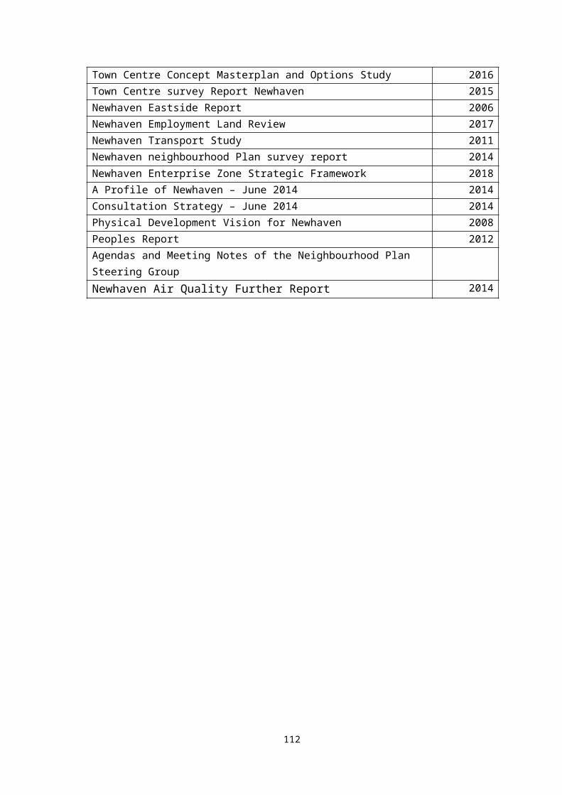
Table Ay Policy H8 – Old Conservative Club, South Way
Final policy in Submission NNP
Land as defined by Proposal Plan 19 is allocated for a minimum of 12 residential units, subject to:a) the compliance with other policies within the Newhaven Neighbourhood Plan and the Lewes District Joint Core Strategy; andb) the following site-specific requirements;• development in this location must make a positive impact on the A259 in terms of good design, be of appropriate scale and massing, and create a positive gateway building.• Due to restrictions in gaining access to the site, the type of unit and tenure would need careful consideration to allow for a reduction in the parking requirement.• Developer contributions are required to include a financial contribution towards car club infrastructure such as car club parking bays and other car club enabling measures, such as membership subsidy.• Provision is made for the storage of cycles and bins for use by occupiers of the residential units.
Note: Affordable Housing should be provided in accordance with Lewes District Councils Affordable Housing Supplementary Planning Document July 2018. Proposals should have regard to Lewes Districts Joint Core Strategy Core Policy 2 – Housing Type, Mix and Density.
Policy H8 Obj 1 housing growth
Obj 2 access to services
Obj 3 social and leisure
Obj 4 heritage and urban
Obj 5 town centre
Obj 6local economy
Obj 7 visitors
Obj 8 brownfield land
Obj 9 biodiversity
Obj 10 sustainable transport
Obj 11 flood risk
++ - - ++ - - - ++ - ++ -
There is no assessment of alternative options against this policy as the preferred housing site has already been assessed against the sustainability objectives. However, the policy as written is now assessed against the objectives.
Recommend: To agree this is a policy that supports the sustainable objectives.
112
APPENDIX F
Table of All Policies Assessed
113
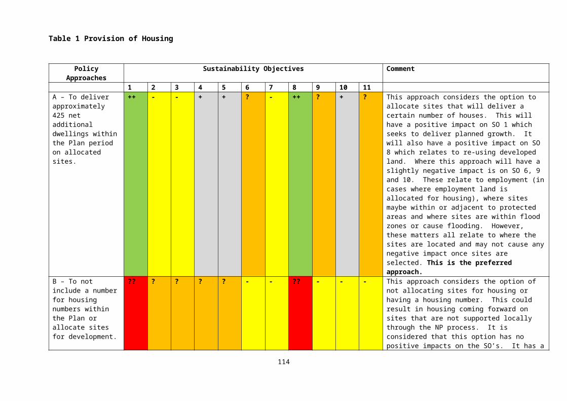
Policy Numbers
Obj 1 housing growth
Obj 2 access to services
Obj 3 social and leisure
Obj 4 heritage and urban
Obj 5 town centre
Obj 6local economy
Obj 7 visitors
Obj 8 brownfield land
Obj 9 biodiversity
Obj 10 sustainable transport
Obj 11 flood risk
Policy TC1 + ++ ++ ++ ++ ++ ++ ++ - - -Policy TC2 - ++ ++ ++ ++ - + + - - -Policy TC3 - - - ++ ++ + + - - - -Policy E1 - - - - - ++ - ++ - - -Policy E2 ++ - - - - ++ - ++ - - -Policy E3 - - ++ ++ ++ ++ ++ - - - -Policy E4 - - - - - ++ - - - - -Policy ES1 + + ++ ++ - + + ++ - ++ +Policy ES2 ++ + + + - ++ + ++ - ++ -Policy ES3 - - ++ - - - - - ++ - -Policy T1 - + ++ - ++ + + - - ++ -Policy T2 - ++ ++ - ++ - ++ - - ++ -Policy R1 - - ++ + - - + - + - -Policy R2 - + ++ - - - ++ - + ++ +Policy NE1 - - - - - - - - ++ - -Policy D1 - + - ++ ++ + + - + + +Policy D2 - + - ++ ++ + + - + + +Policy H1 ++ - - + ++ ++ - + + - -Policy H2: ++ - - + + - - ++ - ++ -Policy H3: ++ - - ++ - ++ - ++ - ++ ++Policy H4: ++ - - ++ + - - ++ - ++ ++Policy H5: ++ - - ++ ++ + + ++ - ++ -Policy H6: ++ - - ++ - - - ++ - - -Policy H7: ++ - - ++ - - - ++ ++ - -Policy H8: ++ - - ++ - - - ++ - ++ -
114