Embed Size (px)
Citation preview


CAROLINA GEOLOGICAL SOCIETYFIELD TRIP GUIDEBOOK
November 14-15, 1987
ANATOMY OF THE ALLEGHANIAN OROGENY AS SEEN FROM THE PIEDMONT OF SOUTH CAROLINA AND GEORGIA
(with a field trip guide on the bedrock geology of the Clark Hill Lake area)
Edited by
Donald T. Secor, Jr.Department of Geological SciencesThe University of South CarolinaColumbia, South Carolina 29208
Front cover: sketch showing the fabric elements of early and late Paleozoicage as observed in the Clark Hill Lake area, by Harmon D. Maher
Copies of this guidebook can be obtained fromSouth Carolina Geological Survey
Harbison Forest RoadColumbia, South Carolina 29210

CAROLINA GEOLOGICAL SOCIETY 1987 OFFICERS
President: Alexander W. RitchieDepartment of GeologyCollege of CharlestonCharleston, SC 29424
Vice-President: Edward F. StoddardDepartment of Marine, Earth,
and Atmospheric SciencesNorth Carolina State UniversityRaleigh, NC 27695
Secretary-Treasurer: S. Duncan Heron, Jr.Department of GeologyDuke UniversityDurham, NC 27706
Board of Directors: James A. DockalDepartment of Earth SciencesUniversity of North CarolinaWilmington, NC 28403
Gail G. GibsonDepartment of Geography and Earth SciencesUniversity of North CarolinaCharlotte, NC 28223
Kenneth A. GillonAmselco Exploration, Inc.1112 Mill StreetCamden, SC 29020
Lucille E. KiteSouth Carolina Geological SurveyHarbison Forest RoadColumbia, SC 29210
ii

CONTENTS
FOREWORD . . . . . . . . . . . . . . . . . . . . . . . . . . . . . . . . . . . . . . . . . . . . . . . . . . . . . . . . . . . . v
DEDICATION . . . . . . . . . . . . . . . . . . . . . . . . . . . . . . . . . . . . . . . . . . . . . . . . . . . . . . . . . . . vi
REGIONAL OVERVIEWDonald T. Secor, Jr. . . . . . . . . . . . . . . . . . . . . . . . . . . . . . . . . . . . . . . . . . . . . . . . . . . . . 1
THE MODOC ZONE – D2 (EARLY ALLEGHANIAN) IN THE EASTERN APPALACHIANPIEDMONT, SOUTH CAROLINA AND GEORGIA
Paul E. Sacks and Allen J. Dennis . . . . . . . . . . . . . . . . . . . . . . . . . . . . . . . . . . . . . . . . . 13
D3 FOLDING IN THE EASTERN PIEDMONT ASSOCIATED WITH ALLEGHANIANTHRUSTING
Harmon D. Maher. . . . . . . . . . . . . . . . . . . . . . . . . . . . . . . . . . . . . . . . . . . . . . . . . . . . . . 23
NATURE OF THE LATE ALLEGHANIAN STRIKE-SLIP DEFORMATION IN THE EAST-ERN SOUTH CAROLINA PIEDMONT: THE IRMO SHEAR ZONE
Allen J. Dennis, Paul E. Sacks, and Harmon D. Maher . . . . . . . . . . . . . . . . . . . . . . . . . 31
FIELD TRIP ITINERARY: ROAD LOG FOR SATURDAY AND SUNDAY, NOVEMBER 14-15, 1987
Harmon D. Maher, Scott McIntyre, Paul E. Sacks, and Donald T. Secor, Jr.. . . . . . . . . 43
iii

FOREWORDOctober, 1978 was the last time that the Carolina Geological Society met to examine the geology of Piedmont
rocks along the Fall Line in South Carolina. Then it had just been realized that the deformed granites and amphibolitefacies metamorphic rocks in the Kiokee belt were the products of an episode of late Paleozoic ductile deformationand regional metamorphism. This deformed belt was the central theme of the 1978 field trip, although at that time, itsregional significance was uncertain. Shortly after the 1978 meeting we began referring to this belt as “Hercynian”because we felt that the region had more in common with the Hercynian in Europe and/or northwestern Africa than itdid with the Alleghanian of the Appalachian foreland. More recently, it has become apparent that rocks in the south-eastern Piedmont comprise one or more exotic terranes that were proximal to Laurentia by the early or middle Paleo-zoic. COCORP seismic reflection studies have shown that the suture with rocks of clear African affinity is locatedbeneath the Coastal Plain in southern Georgia, and that the crystalline rocks north of the suture are most likely alloch-thonous and part of a northwest vergent crystalline thrust sheet that arrived in its present position during the late Pale-ozoic Alleghanian orogeny. Thus, it now appears that the late Paleozoic deformed belt in the Piedmont and theAlleghanian foreland fold and thrust belt are both manifestations of the same regional decollement. We now refer tothe late Paleozoic deformation in the Piedmont as “Alleghanian” because the deformation is thought to be kinemati-cally and chronologically linked to the Alleghanian foreland deformation.
The central theme of this year’s field trip is the Alleghanian deformations along the Georgia-South Carolina bor-der in the Carolina slate, Kiokee and Belair belts. We believe that the chronology and kinematics of these Alleghaniandeformational events furnish important clues regarding plate interactions that occurred during the late Paleozoic col-lision between Gondwana and Laurentia. The detailed mapping in the Clark Hill Reservoir area described in this fieldguide has important implications both for the regional geology and for the mechanics of plate interactions in colli-sional orogens.
v

Dedicated to Duncan Heronin appreciation for his service
to the Carolina Geological Society
vi

CAROLINA GEOLOGICAL SOCIETYGuidebook for 1987 Annual Meeting
Pages 1-11
INTRODUCTIONGeological and geochronological studies have indicated
that important belts of late Paleozoic penetrative deforma-tion and regional metamorphism are present in the Appala-chian Piedmont Province (Snoke and others, 1980; Pavlidesand others, 1982; Glover and others, 1983; Farrar, 1985;Russell and others, 1985; Dallmeyer and others, 1986; Hor-ton and others, 1987). This late Paleozoic deformation in thePiedmont is contemporaneous with the Alleghanian orogenyrecorded in the western Appalachian foreland (Secor andothers, 1986b; Elliott and Aronson, 1987), and seismicreflection data has been interpreted to indicate that the Pied-mont is structurally linked via a regional decollement to boththe Alleghanian foreland to the northwest (Cook and others,1983) and to the late Paleozoic suture with Gondwana to thesoutheast (Nelson and others, 1985). Since 1984, we havebeen engaged in detailed geologic mapping and structuralstudies in rocks that were intensely deformed during the
1
Alleghanian orogeny in the Clark Hill Reservoir area ofSouth Carolina and Georgia. Our results have importantimplications regarding the kinematics of both theAlleghanian orogeny and the late Paleozoic collision withGondwana. The purpose of this field trip and guide is topresent our data and interpretations from the Clark Hill Res-ervoir area.
The effects of the Alleghanian orogeny in the Piedmontare overprinted on rocks that were penetratively deformedand regionally metamorphosed in the early and/or middlePaleozoic. This chapter presents necessary backgroundinformation on the regional geology. The deformational epi-sodes of the Alleghanian orogeny are detailed in subsequentchapters.
LITHOTECTONIC BELTSEarly workers (Crickmay, 1952; King, 1955; Hatcher,
1972) subdivided the Piedmont into several northeast trend-
REGIONAL OVERVIEW
Donald T. Secor, Jr.Department of Geological Sciences
The University of South Carolina, Columbia, SC 29208
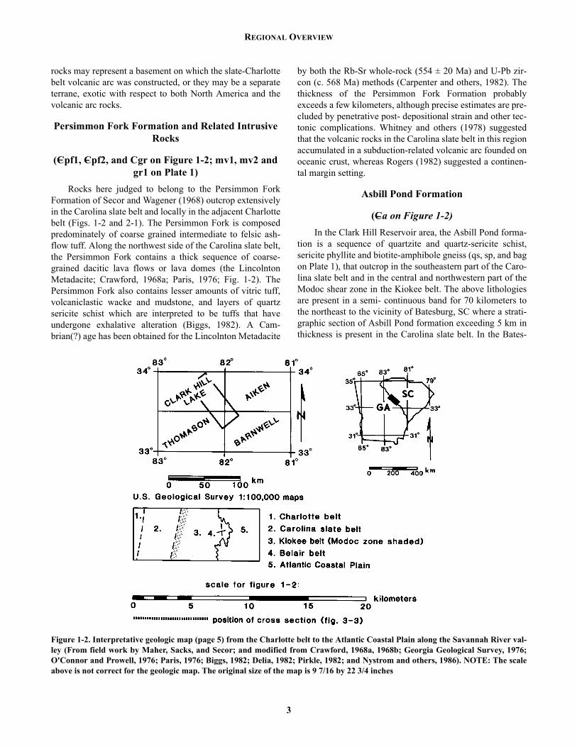
Figure 1-1. Index map of a part of the Southern Appalachian orogen showing some geographic and geologic features referred to inthe text. Massifs of crystalline basement rock are shown in black (modified from Secor and others, 1986b; and from Williams, 1978).

DONALD T. SECOR, JR.
ing lithotectonic belts (Fig. 1-1). In South Carolina, beltscharacterized by low to medium grade regional metamor-phism (Belair, Carolina slate, Kings Mountain, Chauga)alternate with medium to high grade belts (Kiokee, Char-lotte, Inner Piedmont). The
lithotectonic belts of the Piedmont are interpreted tohave formed as a result of folding and faulting of paleoiso-thermal surfaces (Secor and others, 1986b) and the belts aretherefore thought to have little or no fundamental regionalstratigraphic significance. The general area of the field trip(Fig. 1-2) encompasses parts of the Charlotte, Carolina slate,Kiokee, and Belair belts as well as the Atlantic Coastal PlainProvince. The Clarks Hill and Leah quadrangles (Plate 1) arelocated along the boundary between the Carolina slate andKiokee belts.
STRATIGRAPHY
Gneisses and Schists in the Charlotte Belt
(PCgn1 on Figure 1-2) In central and western South Carolina the Charlotte belt
contains sequences of paragneiss, mica schist, feldspathicquartzite, and amphibolite, with small amounts of calc-sili-cate rock and altered ultramafic rock. In places, some of theabove lithologies contain relict textures indicating derivationfrom sedimentary and/or volcanic protoliths. The relation-ship of the gneisses and schists in the Charlotte belt to theless metamorphosed rocks in the Carolina slate belt is con-troversial and uncertain. Higgins and others (1984; 1987)have suggested that the Charlotte belt is predominately madeup of rocks that were incorporated in a late Precambrian-Cambrian accretionary complex located adjacent to a sub-duction- related volcanic arc. In the Blair-Salem Crossroadsarea near Monticello Reservoir, Hauck (1984) noted similar-ities between the rocks in the Charlotte belt and those in theslate belt and suggested that the rocks in the two belts were,at least in part, stratigraphic equivalents. Along the south-eastern edge of the Charlotte belt, the metavolcanic andmetasedimentary rocks are characteristically cut by sheetsand irregular intrusive bodies of variably deformed felsicorthogneiss (these are not shown on Figure 1-2). In manyplaces these orthogneisses are porphyritic and/or containrelict
granophyric texture suggesting that they originated ashypabyssal, sub-volcanic plutons. In South Carolina, it hasbeen suggested that the above plutons represent the intrusiveequivalents of eruptive felsic volcanic rocks in the adjacentCarolina slate belt (Weisenfluh and Snoke, 1978; Peck,1981; Simpson, 1981; Secor and others, 1982; Halik, 1983;Kirk, 1985). Petrologic and geochemical comparisons ofintrusive hypabyssal rocks in the Charlotte belt with theirsupposed extrusive equivalents in the Carolina slate belt
2
have indicated that some of the hypabyssal rocks are richerin potassium than any of the volcanic rocks in the slate belt(Biggs, 1982; Secor and others, 1982; Halik, 1983). Thesedifferences may indicate more intensive diagenetic alterationof the originally glassy extrusive rocks. Alternatively, asargued by Biggs (1982), the hypabyssal intrusive rocks maynot be the equivalents of the felsic volcanic rocks in the slatebelt. A recent U-Pb zircon upper intercept age of 550 ± 4 Mafor the hypabyssal Little Mountain pluton (Dallmeyer andothers, 1986) indicates a Lower Cambrian(?) age for thehypabyssal rocks. The sequences of metasedimentary andmetavolcanic rocks in the Charlotte belt that are cut by theabove Lower Cambrian(?) intrusives must therefore besomewhat older, perhaps late Precambrian.
Migmatitic Gneisses and Schists in the Interior of the Kiokee Belt
(PCgn2 and PC um on Figure 1-2)The interior of the Kiokee belt is a migmatitic complex
made up of biotite amphibole paragneiss (mbag on Plate 1),leucocratic paragneiss (lpg, Plate 1), sillimanite schist (ms,Plate 1), amphibolite locally containing ultramafic schistsand serpentinite (ma, Plate 1), and feldspathic metaquartzite(not present on Plate 1). Thin layers and nodules of rock con-taining calcium rich garnet and plagioclase, diopside, andepidote (calc-silicate assemblage?) are a ubiquitous butminor component of the migmatitic complex. The ba andbag units in the southeastern part of the Modoc zone may bedeformed equivalents of ma and mbag in the interior of theKiokee belt (Sacks and Dennis, this volume, and Plate 1).The rocks in the interior of the Kiokee belt are thought to bebounded by faults on both the southeast and northwest. Thesoutheast boundary is the Augusta fault which juxtaposes themigmatitic rocks against the low-grade metavolcanic rocksof the Belair belt (Maher, 1987; Fig. 1-2). The northwestboundary is interpreted to be a cryptic fault embedded in theModoc shear zone (Sacks and Dennis, this volume) whichjuxtaposes deformed equivalents of the migmatic complexagainst the rocks of the Asbill Pond formation (Fig. 1-2).Farrar (1985) suggested that the rocks in the interior of theKiokee belt might be middle Proterozoic basement similar tothat thought to be present in the interior of the Raleigh belt.However, neither anorthosites nor textural evidence for relictPrecambrian granulite facies metamorphism have beenfound in the Kiokee belt. Structural evidence presented bySacks and Dennis (this volume) suggests that the migmaticrocks in the interior of the Kiokee belt were located relativeto the Carolina slate belt at least tens of kilometers north-northeast of their present position prior to the Alleghanianorogeny. The migmatic rocks may be stratigraphic equiva-lents of the POAL(C,_)gn1 unit in the Charlotte belt whichthey resemble lithologically. Alternatively, the migmatic
REGIONAL OVERVIEW
rocks may represent a basement on which the slate-Charlottebelt volcanic arc was constructed, or they may be a separateterrane, exotic with respect to both North America and thevolcanic arc rocks.
Persimmon Fork Formation and Related Intrusive Rocks
(Cpf1, Cpf2, and Cgr on Figure 1-2; mv1, mv2 and gr1 on Plate 1)
Rocks here judged to belong to the Persimmon ForkFormation of Secor and Wagener (1968) outcrop extensivelyin the Carolina slate belt and locally in the adjacent Charlottebelt (Figs. 1-2 and 2-1). The Persimmon Fork is composedpredominately of coarse grained intermediate to felsic ash-flow tuff. Along the northwest side of the Carolina slate belt,the Persimmon Fork contains a thick sequence of coarse-grained dacitic lava flows or lava domes (the LincolntonMetadacite; Crawford, 1968a; Paris, 1976; Fig. 1-2). ThePersimmon Fork also contains lesser amounts of vitric tuff,volcaniclastic wacke and mudstone, and layers of quartzsericite schist which are interpreted to be tuffs that haveundergone exhalative alteration (Biggs, 1982). A Cam-brian(?) age has been obtained for the Lincolnton Metadacite
3
by both the Rb-Sr whole-rock (554 ± 20 Ma) and U-Pb zir-con (c. 568 Ma) methods (Carpenter and others, 1982). Thethickness of the Persimmon Fork Formation probablyexceeds a few kilometers, although precise estimates are pre-cluded by penetrative post- depositional strain and other tec-tonic complications. Whitney and others (1978) suggestedthat the volcanic rocks in the Carolina slate belt in this regionaccumulated in a subduction-related volcanic arc founded onoceanic crust, whereas Rogers (1982) suggested a continen-tal margin setting.
Asbill Pond Formation
(Ca on Figure 1-2)In the Clark Hill Reservoir area, the Asbill Pond forma-
tion is a sequence of quartzite and quartz-sericite schist,sericite phyllite and biotite-amphibole gneiss (qs, sp, and bagon Plate 1), that outcrop in the southeastern part of the Caro-lina slate belt and in the central and northwestern part of theModoc shear zone in the Kiokee belt. The above lithologiesare present in a semi- continuous band for 70 kilometers tothe northeast to the vicinity of Batesburg, SC where a strati-graphic section of Asbill Pond formation exceeding 5 km inthickness is present in the Carolina slate belt. In the Bates-
Figure 1-2. Interpretative geologic map (page 5) from the Charlotte belt to the Atlantic Coastal Plain along the Savannah River val-ley (From field work by Maher, Sacks, and Secor; and modified from Crawford, 1968a, 1968b; Georgia Geological Survey, 1976;O'Connor and Prowell, 1976; Paris, 1976; Biggs, 1982; Delia, 1982; Pirkle, 1982; and Nystrom and others, 1986). NOTE: The scaleabove is not correct for the geologic map. The original size of the map is 9 7/16 by 22 3/4 inches

DONALD T. SECOR, JR.
4

REGIONAL OVERVIEW
5

DONALD T. SECOR, JR.
burg area, the Asbill Pond formation is less stronglydeformed than it is in the Clark Hill Reservoir area, and ithas experienced only low-grade regional metamorphism. Inthe Batesburg area, the following protolithologies can be rec-ognized in the Asbill Pond Formation:
1) thin bedded (1-10 mm) fine-grained quartz sandstonecontaining relict sedimentary structures suggestive of depo-sition in a tidal shelf environment.
2) medium to coarse grained quartzofeldspathic sand-stone containing lenticular crossbeds 2-200 cm thick. Insome places these crossbeds are draped by thin pelitic part-ings, suggestive of deposition in an environment where sedi-ment transport was dominated by tidal currents.
3) thin-bedded to massive mudstone and feldspathicwacke.
4) intermediate tuff and tuff breccia, and/or flow brec-cia.
The above lithologies intergrade with each other andalso are interlayered with the underlying Persimmon ForkFormation indicating that the Asbill Pond is conformableabove the Persimmon Fork. Along the northwest side of theClouds Creek granite near Batesburg, the upper part of theAsbill Pond formation contains a mudstone sequence whichhas yielded an assemblage of Middle Cambrian, Acado-Bal-tic trilobites (Samson, 1984). This assemblage indicates thatthe South Carolina slate belt was faunally isolated fromNorth America (Laurentia) during the Middle Cambrian andhas been interpreted to indicate that the slate belt comprisesan exotic terrane (the Carolina terrane) that was accreted toNorth America subsequent to the Middle Cambrian (Secorand others, 1983).
Richtex Formation
(Cr on Figure 1-2; mm on Plate 1)The Richtex Formation is a sequence of thin bedded to
massive mudstone and wacke interlayered with intermediateto mafic tuffs and flows, and intruded by sheets and plugs ofhypabyssal (?) mafic igneous rocks. The thickness of theRichtex Formation probably exceeds a few kilometers; moreprecise estimates are not possible because of penetrativestrain and extensive folding. The Richtex Formation is awidespread stratigraphic unit in the slate belt of central andwestern South Carolina (Fig. 2-1). Structural relationships incentral South Carolina (Simpson, 1981; Peck, 1982; Halik,1983; Kirk, 1985; Secor and others, 1986a) indicate that theRichtex overlies the Persimmon Fork; however, it is uncer-tain if the contact is stratigraphic or tectonic. The followingworking hypotheses are considered in a subsequent analysisof the relationship between the Richtex Formation and theother stratigraphic units in the Carolina slate belt:
1) the Richtex and Asbill Pond Formations representdifferent depositional environments; however, they are both
6
approximately the same age and both conformably overliethe Persimmon Fork Formation;
2) the Richtex Formation is younger than both the AsbillPond and the Persimmon Fork Formations and is separatedfrom them by an angular unconformity;
3) there is a fault separating the Richtex Formation fromthe Asbill Pond and Persimmon Fork Formations.
The following observations are useful in discriminatingbetween the above hypotheses:
1) On Bussey Point in Clark Hill Reservoir, outcropbands of Richtex Formation and Asbill Pond formationoccur within 500 meters of each other on opposite sides of anoutcrop band of Persimmon Fork Formation (Plate 1). Theirproximity here would seem to rule out an interpretation[such as 1) above] wherein they are the same age and con-formable above the Persimmon Fork but accumulated in dif-ferent depositional environments.
2) Mafic hypabyssal rocks are scarce or absent in manyareas of the Persimmon Fork Formation whereas they arecommon in the Richtex Formation. The Persimmon ForkFormation should contain more mafic intrusive rocks if theRichtex Formation had been deposited (either conformablyor unconformably) on top of it.
3) On a regional scale, the surface separating the Rich-tex and Persimmon Fork Formations is discordant to litho-logic subunits within both Formations.
4) The Richtex Formation contains the same penetrativedeformational fabrics (D1, discussed subsequently) inapproximately the same orientations as in the adjacent Per-simmon Fork and Asbill Pond Formations.
5) At least locally in central South Carolina (near Stop14 in Secor and Wagener, 1968), the contact between theRichtex and Persimmon Fork Formations has been observedin outcrop to be a ductile, pre- to early syntectonic fault (rel-ative to D1 deformational fabrics).
An interpretation in which the Richtex is in depositionalcontact with the Persimmon Fork (either conformably orunconformably) is difficult to reconcile with the evidencelisted above, whereas an interpretation in which the Richtexis in fault contact with the Persimmon Fork and Asbill Pondseems to be compatible with the evidence. We therefore ten-tatively interpret the Richtex to be part of a regional alloch-thon that was emplaced prior to or during the D1deformation. Hopefully, during the next few years, the abovehypothesis will be tested by additional field and geochrono-logical studies.
The age of the Richtex Formation is uncertain. If it is indepositional contact above the Persimmon Fork, it must beyounger than c. 550 Ma (Cambrian? or younger). However,if the Richtex is allochthonous, it could be older than thePersimmon Fork. A late Precambrian age would be compati-ble with the observed very unfossiliferous character of theRichtex.

REGIONAL OVERVIEW
D1 (DELMAR) DEFORMATIONIn South Carolina, the slate belt has been affected by an
early to middle Paleozoic deformational event (the Delmardeformation of Secor and others, 1986a) characterized bypenetrative strain, tight to isoclinal folding and greenschistfacies (Carolina slate belt) to amphibolite facies (Charlottebelt) regional metamorphism. Major D1 folds (such as theSaluda synclinorium, Plate 1 and Figure 1-2) are primarilyresponsible for the distribution of stratigraphic units in theCarolina slate belt. D1 must have occurred more recentlythan Middle Cambrian because the fossiliferous MiddleCambrian rocks in the Asbill Pond formation contain D1 fab-ric elements. D1 is constrained to be older than c. 340 Ma by40Ar/39Ar whole-rock phyllite ages in central South Carolina(Dallmeyer and others, 1986). Field studies along the slatebelt-Charlotte belt border (Secor and others, 1982; Halik,1983; Kirk, 1985) suggest that the same D1 fabric elementsare present in the Charlotte belt. In the Charlotte belt of cen-tral South Carolina, the c. 415 Ma Newberry granite (Fulla-gar, 1981) contains xenoliths which contain rotated D1 fabricelements. If the D1 events in the slate and Charlotte belts arethe same, D1 in the slate belt must have occurred prior to c.415 Ma.
SILURO-DEVONIAN(?) INTRUSIVE ROCKS
(SDgb on Figure 1-2)The Charlotte belt of North and South Carolina contains
a suite of post-D1 intrusive rocks (granite, syenite, gabbro)which range in age from c. 385-415 Ma (Fullagar, 1971;Butler and Fullagar, 1978; McSween and others, 1984). Thebodies of intrusive gabbro in the Charlotte belt at the north-west end of Figure 1-2 are tentatively interpreted to belongto this Siluro-Devonian suite. The regional tectonic signifi-cance of the Siluro-Devonian intrusive rocks is uncertain.
MIDDLE PALEOZOIC DEFORMATIONIn North Carolina the Siluro-Devonian intrusive rocks
in the Charlotte belt are interpreted to have experienced arelatively mild mid-Paleozoic deformation (Butler and Fulla-gar, 1978). It is uncertain if the above deformational effectsextend eastward into the Carolina slate belt (Glover and oth-ers, 1983) or southwestward as far as the Georgia- SouthCarolina border. In central South Carolina, 40Ar/39Ar whole-rock phyllite age spectra from the northwestern Carolinaslate belt and 40Ar/39Ar hornblende age spectra from thesoutheastern Charlotte belt indicate rapid cooling from a midPaleozoic (c. 340-360 Ma) thermal event. It is uncertain ifthis event was accompanied by deformation or if it affectedthe Carolina slate and Charlotte belts in the Clark Hill Reser-voir area.
7
LATE PALEOZOIC GRANITIC INTRUSIVE ROCKS
(gr2 and dgr on Plate 1; Cgr and Cdgr on Figure 1-2)An intrusive magmatic arc, containing dozens of indi-
vidual granitic plutons of Carboniferous and Permian age,extends through the Piedmont from Maryland to Georgia(Sinha and Zietz, 1982). In most places, the above plutonshave not been penetratively deformed, and their contactmetamorphic aureoles overprint fabric elements in the sur-rounding rocks. Conversely, in some places along the FallLine (Kish and Fullagar, 1978; Secor and Snoke, 1978;Snoke and others, 1980; Pavlides and others, 1982; Farrar,1985; Russell and others, 1985; Dallmeyer and others, 1986)and locally within the Kings Mountain belt (Horton and oth-ers, 1987) the late Paleozoic plutons contain a moderate tostrong, locally mylonitic deformation fabric. Thesedeformed late Paleozoic granites are an important manifesta-tion of Alleghanian deformation in the Piedmont. In theClark Hill Reservoir area, undeformed granitic rocks at thenorthwest and southeast ends of Figure 1-2 (the Goshen andAppling granites, respectively) are interpreted to be of latePaleozoic age. Within the Modoc zone (Plate 1), there arenumerous sheets of strongly deformed granitic rock, up to 1km in thickness and several kilometers long, that are inter-preted to be of late Paleozoic age. This belt of deformedgranites in the Modoc zone extends continuously into centralSouth Carolina where the inferred late Paleozoic ages havebeen confirmed by Rb-Sr whole-rock dating (Snoke and oth-ers, 1980) and by U-Pb zircon dating (Dallmeyer and others,1986). Geochronological studies in central South Carolinaindicate that the late Paleozoic plutonic activity and peak ofregional amphibolite facies metamorphism coincidedapproximately in time with the most intense deformation.
LATE PALEOZOIC (ALLEGHANIAN) TEC-TONOTHERMAL ACTIVITY
IntroductionIn central South Carolina field and geochronological
studies indicate that the effects of the Alleghanian orogenycan be divided into the following deformation phases: D2(Lake Murray deformation, 295-315 Ma), D3 (Clark Hilldeformation, 285-295 Ma), and D4 (Irmo deformation, 268-290 Ma), (Dallmeyer and others, 1986; Secor and others,1986a). Our studies indicate that these same deformationphases are present in the Clark Hill Reservoir area, and thatfabric elements attributable to these phases are present atmany intermediate locations in the northwestern Kiokee beltbetween Clarks Hill and Columbia. Maher (1987) hasobtained a few conventional potassium-argon ages from theSavannah River area which are compatible with the more

DONALD T. SECOR, JR.
detailed geochronological studies (Dallmeyer and others,1986) completed in central South Carolina. Therefore, weare confident that the above correlation of deformationphases is correct.
The effects of the Alleghanian orogeny are exception-ally well exposed in the Clark Hill reservoir area, and fieldstudies here have greatly improved our understanding of theAlleghanian deformation events and their regional signifi-cance. The results of our studies are detailed in subsequentchapters (this volume) by Sacks and Dennis (D2), Maher(D3), and Dennis and others (D4). These chapters supplementthe following brief summary of Alleghanian deformation inthe Savannah River area.
The Modoc ZoneIn the Clark Hill Reservoir area, the Modoc zone is an
approximately 5 km thick D2 ductile shear zone that sepa-rates the upper amphibolite facies migmatites in the interiorof the Kiokee belt from the greenschist facies Carolina slatebelt. The quartzite, phyllite, and paragneiss units within theModoc zone are, for the most part, interpreted to be correla-tive with the Asbill Pond formation in the low-grade Caro-lina slate belt of central South Carolina. The elevatedmetamorphic grade of the Asbill Pond in the Modoc zone(M2 regional amphibolite facies) is interpreted to be a conse-quence of tectonic juxtaposition against the hot rocks in theinterior of the Kiokee belt during D2. The Modoc zone isthought to have originally dipped gently to the northwest andto have had major components of normal slip and dextralstrike slip. The net slip of the Modoc zone is at least tens ofkilometers. The Modoc zone contains virtually all of thestrongly deformed Permo-Carboniferous granite in theSavannah River area and may be the only D2 structurepresent in the northwestern Kiokee belt. The age of the tec-tonic fabrics in the interior of the Kiokee belt is uncertain.
The Augusta FaultThe Augusta fault is located along the southeast side of
the Kiokee belt where it juxtaposes low-grade metavolcanicrocks of the Belair belt against migmatic rocks in the Kiokeebelt. The fault is spectacularly exposed in the Martin-Mari-etta quarry near Augusta (Stop 12) where it is associatedwith 100-200 meters of mylonite and dips c. 45o southeast-ward. The Augusta fault approximately coincides with aseries of prominent aeromagnetic anomalies (Daniels, 1974)that are interpreted to indicate a regionally important “east-ern Piedmont fault system” (Hatcher and others, 1977). TheAugusta fault has been variously interpreted as a strike slipfault (Bobyarchick, 1981), as a thrust (Maher, 1978, 1979;Snoke and Secor, 1982), and as a low angle normal fault(Maher, 1978). A recent study of shear-sense criteria in themylonite (Maher, 1987) indicates a major component of nor-mal displacement. Secor and others (1986a) suggested that
8
the Modoc zone may be folded over the crest of the Kiokeeanticlinorium and may correlate with the Augusta fault. Thisinterpretation is incompatible with the observed shear senseand is here abandoned. Although the time of movement ofthe Augusta fault is not well constrained by geochronologi-cal data, field studies suggest that it was active near the peakof M2 amphibolite facies regional metamorphism (c. 295-315 Ma).
The Kiokee AntiformThe D3 Kiokee antiform is defined by folded foliation
surfaces of various ages. These include the S1 foliation in theCarolina slate and Belair belts, the S2 foliation in the Modoczone, and the migmatic layering of uncertain age in the inte-rior of the Kiokee belt. The Kiokee belt and adjacent por-tions of the Carolina slate and Belair belts contain apopulation of horizontal to gently plunging, northwest ver-gent mesoscopic folds that are interpreted to be F3. Secor andothers (1986b) interpreted the Kiokee antiform to be a ramp-antiform associated with northwestward motion along aregional decollement. Maher (this volume) finds that thegeometry of the antiform more closely approximates theform to be expected for a fault propagation fold. The verticalto steep northwest dips in the Modoc zone and throughoutmuch of the Carolina slate belt in the Clark Hill Lake areaare interpreted to be a result of rotation in the steep limb ofthe fault propagation fold. Geochronological studies in cen-tral South Carolina (Dallmeyer and others, 1986) suggest anepisode of uplift, erosion and cooling during c. 285-295 Ma,which is interpreted to be a consequence of northwestwardvergent thrusting and F3 folding.
The Irmo Shear ZoneThe D4 Irmo shear zone was first recognized in central
South Carolina (Secor and others, 1986a; Dennis and Secor,1987) where it crosses from the Kiokee belt to the Carolinaslate belt (Fig. 2-1). The primary manifestation of the Irmoshear zone are normal slip and reverse slip crenulationswhich overprint D2 and D3 fabric elements and which indi-cate a predominately horizontal dextral shear- sense. At theeast end of Lake Murray, the D2 Modoc zone is dextrallyfolded by the northeast plunging Irmo antiform and Lexing-ton synform. This dextral pattern is interpreted to result fromthe constructive interference of F3 and F4 folds. Structuralstudies in the above area suggest that the displacement on theD4 Irmo shear zone is at most c. 30 km. In the Clark HillLake area, D4 strain is in part concentrated in two narrowbands of sericite phyllite, leading to the development ofspectacular normal slip crenulations (Stops 4 and 5).
The Belair FaultIn the vicinity of Augusta, the southeastern edge of the
Kiokee belt and the Augusta fault are offset by the north-

REGIONAL OVERVIEW
northeast trending Belair fault (Fig. 1-2; Stop 12). the laststages of movement on the Belair fault were high- anglereverse resulting in cumulative offsets of 30 meters and 12meters for Late Cretaceous and Eocene strata, respectively,in the Atlantic Coastal Plain (O'Connor and Prowell, 1976;Prowell and O'Connor, 1978). The horizontal separation ofthe late Paleozoic Augusta fault by the Belair fault is c. 23km (sinistral, Prowell and O'Connor, 1978). Bramlett andothers (1982) have suggested that in the late Paleozoic theBelair fault functioned as a tear, genetically related to move-ment on the Augusta fault.
SUMMARY OF REGIONAL GEOLOGICAL HIS-TORY OF THE SAVANNAH RIVER AREA1. The Persimmon Fork and Asbill Pond Formations
were deposited during the early and middle Cambrian inassociation with a subduction related (?) volcanic arc.
2. The Richtex Formation of unknown age is tentativelyinterpreted to comprise an allochthon that was emplaced inthe early Paleozoic.
3. During the D1 Delmar deformation (sometime duringc. 415 and 525 Ma), the rocks in the Carolina slate and Char-lotte belts were penetratively deformed and tightly folded.M1 was geeenschist facies in the slate belt and amphibolitefacies in the Charlotte belt.
4. During c. 385-415 Ma a mafic to felsic suite of plu-tonic rocks were emplaced in the Charlotte belt.
5. It is uncertain if mid-Paleozoic deformation and/orthermal activity affected the rocks in the Savannah Riverarea.
6. The Savannah River area contains granitic plutonsfrom a regionally extensive late Paleozoic (c. 285-330 Ma)magmatic arc. These plutons are strongly deformed in thenorthwestern part of the Kiokee belt (Modoc zone) but areweakly deformed to undeformed elsewhere in the SavannahRiver area.
7. Three deformation events (D2-D4) comprise theAlleghanian orogeny in the Savannah River area.
a. The D2 (Lake Murray) deformation (295-315 Ma) isassociated with deformation in the c. 5 km thick Modocshear zone. The Modoc zone originally dipped gently north-west and had important components of both normal slip anddextral strike slip. The Augusta fault, along the southeastside of the Kiokee belt, has an important component of nor-mal movement and may also be a D2 structure.
b. The D3 (Clark Hill) deformation (285-295 Ma) isassociated with northwestward motion of the Piedmont crys-talline thrust sheet above a regional decollement. The D3Kiokee anticlinorium is interpreted to be a fault propagationfold above the decollement.
c. The D4 (Irmo) deformation (268-290 Ma) is associ-ated with dextral motion in the northeast trending Irmo shearzone. In the Clark Hill area, the Irmo shear zone coincides
9
with the Modoc zone and overprints the associated D2 struc-tures. The Irmo shear zone is interpreted to indicate dextralmotion between Laurentia and Gondwana in the final stagesof the Alleghanian orogeny.
8. During the Triassic and/or Jurassic the Piedmontrocks were cut by northeast trending brittle faults andintruded by northwest trending diabase dikes.
9. During the late Mesozoic and early Cenozoic, theCoastal Plain and Piedmont near Augusta were cut by thenorth- northeast trending Belair fault. The Belair fault is ahigh angle reverse fault which moved approximately 18meters and 12 meters in the Upper Cretaceous and LowerTertiary, respectively (Prowell and O'Connor, 1978). TheBelair fault may be a reactivated late Paleozoic tear fault(Bramlett and others, 1982).
ACKNOWLEDGMENTSMy ideas about the geological history of the Savannah
River area have been shaped by discussions with Allen Den-nis, Harmon Maher, and Paul Sacks during the last fewyears. I also appreciate the expert help of Terry Dennis withdrafting and Joyce Goodwin with typing. Ole Olson andAlan Zupan of the South Carolina Geological Survey havebeen especially helpful in matters pertaining to the publica-tion of this guide. This work was supported by National Sci-ence Foundation grant EAR-8508123.
REFERENCES CITEDBiggs, T.H., 1982, The geology of the McCormick area, McCor-
mick County, South Carolina: Athens, University of GeorgiaMaster's Thesis, 222 p.
Bobyarchick, A.R., 1981, The eastern Piedmont fault system and itsrelationship to Alleghanian tectonics in the southern Appala-chians: Journal of Geology, v. 89, p. 335-347.
Bramlett, K.W., Secor, D.T., Jr., and Prowell, D.C., 1982, TheBelair fault: A Cenozoic reactivation structure in the easternPiedmont: Geological Society of America Bulletin, v. 93, p.1109-1117.
Butler, J.R., and Fullagar, P.D., 1978, Petrochemical and geochro-nological studies of plutonic rocks in the southern Appala-chians: III. Leucocratic adamellites of the Charlotte belt nearSalisbury, North Carolina: Geological Society of America Bul-letin, v. 89, p. 460-466.
Carpenter, R.H., Odom, A.L., and Hartley, M.E., III, 1982, Geo-chronological investigation of the Lincolnton metadacite, Geor-gia and South Carolina, in Bearce, D.N., Black, W.W., Kish,S.A. and Tull, J.F., eds., Tectonic studies in the Talladega andCarolina slate belts, southern Appalachian orogen: GeologicalSociety of America Special Paper 191, p. 145-152.
Cook, F.A., Brown, L.D., Kaufman, S., and Oliver, J.E., 1983, TheCOCORP seismic reflection traverse across the southern Appa-lachians: Tulsa, Oklahoma, American Association of PetroleumGeologists Studies in Geology, no. 14, 61 p.
Crawford, T.J., 1968a, Geologic map, Lincoln County, Georgia:

DONALD T. SECOR, JR.
Atlanta, Georgia Geological Survey, Central Savannah RiverArea Planning and Development Commission.
Crawford, T.J., 1968b, Geologic map, Columbia County, Georgia:Atlanta, Georgia Geological Survey, Central Savannah RiverArea Planning and Development Commission.
Crickmay, G.W., 1952, Geology of the crystalline rocks of Georgia:Atlanta, Georgia Geological Survey Bulletin 58, 54 p.
Dallmeyer, R.D., Wright, J.E., Secor, D.T., Jr., and Snoke, A.W.,1986, Character of the Alleghanian orogeny in the southernAppalachians: Part II. Geochronological constraints on the tec-tonothermal evolution of the eastern Piedmont in South Caro-lina: Geological Society of America Bulletin: v. 97, p. 1329-1344.
Daniels, D.L., 1974, Geologic interpretation of geophysical maps,central Savannah River area, South Carolina and Georgia: U.S.Geological Survey, Geophysical Investigations Map GP-893,1:250,000, 3 sheets, text.
Delia, R.G., 1982, The geology of the southern half of the Willing-ton 7 1/2' quadrangle, South Carolina-Georgia: Athens, Univer-sity of Georgia Master's Thesis, 174 p.
Dennis, A.J., and Secor, D.T., Jr., 1987, A model for the develop-ment of crenulations in shear zones with applications from thesouthern Appalachian Piedmont: Journal of Structural Geology,in press.
Elliott, W.C., and Aronson, J.L., 1987, Alleghanian episode of K-bentonite illitization in the southern Appalachian Basin: Geol-ogy, v. 15, p. 735-739.
Farrar, S.S., 1985, Tectonic evolution of the easternmost Piedmont,North Carolina: Geological Society of America Bulletin, v. 96,p. 362-380.
Fullagar, P.D., 1971, Age and origin of plutonic intrusions in thePiedmont of the southeastern Appalachians: Geological Societyof America Bulletin, v. 82, p. 2845-2862.
Fullagar, P.D., 1981, Summary of Rb-Sr whole-rock ages for SouthCarolina: South Carolina Geology, South Carolina GeologicalSurvey, South Carolina State Development Board, v. 25, p. 29-32.
Georgia Geological Survey, 1976, Geologic map of Georgia:Atlanta, 1:500,000.
Glover, L., III, Speer, J.A., Russell, G.S., and Farrar, S.S., 1983,Ages of regional metamorphism and ductile deformation in thecentral and southern Appalachians: Lithos, v. 16, p. 223-245.
Halik, R.S., 1983, Characterization of the Charlotte/Carolina slatebelt boundary in the Silverstreet and Denny quadrangles, SouthCarolina: Columbia, University of South Carolina Master'sThesis, 83 p.
Hatcher, R.D., Jr., 1972, Developmental model for the southernAppalachians: Geological Society of America Bulletin, v. 83, p.2735-2760.
Hatcher, R.D., Jr., Howell, D.E., and Talwani, P., 1977, EasternPiedmont fault system: Speculations on its extent: Geology, v.5, p. 636-639.
Hauck, M.L., 1984, Geologic characterization of the Charlotte beltin South Carolina: Columbia, University of South CarolinaMaster's Thesis, 74 p.
Higgins, M.W., Atkins, R.L., Crawford, T.J., Crawford, R.F., III,and Cook, R.B., 1984, A brief excursion through two thruststacks that comprise most of the crystalline terrane of Georgiaand Alabama: Atlanta, Georgia Geological Society 19th Annual
10
Field Trip Guidebook, 67 p.Higgins, M.W., Crawford, R.F., III, Atkins, R.L., and Crawford,
T.J., 1987, The Macon complex; an ancient accretionary com-plex in the southern Appalachians: Geological Society ofAmerica Special Paper, in press.
Horton, J.W., Jr., Sutter, J.F., Stern, T.W., and Milton, D.J., 1987,Alleghanian deformation, metamorphism, and granite emplace-ment in the central Piedmont of the southern Appalachians:American Journal of Science, v. 287, p. 635-660.
King, P.B., 1955, A geologic section across the southern Appala-chians: An outline of the geology in the segment in Tennessee,North Carolina and South Carolina, in Russell, R.J., ed., Guidesto southeastern geology: Boulder, Colorado, Geological Societyof America, p. 332-373.
Kirk, P.D., 1985, Geology of the southern half of the Prosperity 7 1/2' quadrangle and the northern half of the Delmar 7 1/2' quad-rangle, South Carolina: Columbia, University of South CarolinaMaster's Thesis, 30 p.
Kish, S.A., and Fullagar, P.D., 1978, Summary of geochronologicaldata for late Paleozoic plutons from high grade metamorphicbelts of the eastern Piedmont of North Carolina, South Caro-lina, and Virginia, in Snoke, A.W., ed., Geological investiga-tions of the eastern Piedmont, southern Appalachians:Columbia, South Carolina Geological Survey, Carolina Geo-logical Society Guidebook for 1978, p. 61-64.
Maher, H.D., Jr., 1978, Stratigraphy and structure of the Belair andKiokee belts near Augusta, Georgia, in Snoke, A.W.,ed., Geo-logical investigations of the eastern Piedmont, southern Appa-lachians: Columbia, South Carolina Geological Survey,Carolina Geological Society Guidebook for 1978, p. 47-54.
Maher, H.D., Jr., 1979, Stratigraphy, metamorphism and structureof the Kiokee and Belair belts near Augusta, Georgia: Colum-bia, University of South Carolina Master's Thesis, 94 p.
Maher, H.D., Jr., 1987, Kinematics of Augusta fault zone mylo-nites, Savannah River area, South Carolina and Georgia: Amer-ican Journal of Science, in press.
McSween, H.Y., Jr., Sando, T.W., Clark, R.S., Harden, J.T., andStrange, E.A., 1984, The gabbro-metagabbro association of thesouthern Appalachian Piedmont: American Journal of Science,v. 284, p. 437- 461.
Nelson, K.D., Arnow, J.A., McBride, J.H., Willemin, J.H., Huang,J., Zheng, L., Oliver, J.E., Brown, L.D., and Kaufman, S., 1985,New COCORP profiling in the southeastern United States. PartI: Late Paleozoic suture and Mesozoic rift basin: Geology, v.13, p. 714-718.
Nystrom, P.G., Jr., Willoughby, R.H., and Kite, L.E., 1986, Creta-ceous- Tertiary stratigraphy of the upper edge of the CoastalPlain between North Augusta and Lexington, South Carolina:Columbia, South Carolina Geological Survey, Carolina Geo-logical Society Field Trip Guidebook 1986, 82 p.
O'Connor, B.J., and Prowell, D.C., 1976, The geology of the Belairfault zone and basement rocks of the Augusta, Georgia area; inChowns, T.M., compiler, Stratigraphy, structure, and seismicityin slate belt rocks along the Savannah River: Georgia Geologi-cal Survey, Guidebook 16, p. 21-32.
Paris, T.A., 1976, The geology of the Lincolnton 7 1/2' quadrangle,Georgia-South Carolina: Athens, University of Georgia Mas-ter's Thesis, 191 p.
Pavlides, L., Stern, T.W., Arth, J.G., Muth, K.G., and Newell, M.F.,

REGIONAL OVERVIEW
1982, Middle and upper Paleozoic granitic rocks in the Pied-mont near Fredericksburg, Virginia: Geochronology: U. S.Geological Survey Professional Paper 1231-B, 9 p.
Peck, L.S., 1981, Geology of the Little Mountain and Chapin quad-rangles, South Carolina: A study of the stratigraphic relation-ship between the Carolina slate belt and the Charlotte belt:Columbia, University of South Carolina M.S. Thesis, 50 p.
Pirkle, W.A., 1982, Geological framework of the Winterseat quad-rangle in the southwestern portion of the Carolina slate belt,South Carolina: Columbia, South Carolina Geological Survey,South Carolina Geology, v. 26, p. 69-79.
Prowell, D.C., and O'Connor, B.J., 1978, Belair fault zone: Evi-dence of Tertiary fault displacement in eastern Georgia: Geol-ogy, v. 6, no. 11, p. 681-684.
Rogers, J.J.W., 1982, Criteria for recognizing environments of for-mation of volcanic suites; Application of these criteria to volca-nic suites in the Carolina slate belt, in Bearce, D.N., Black,W.W., Kish, S.A., and Tull, J.F., eds., Tectonic studies in theTalladega and Carolina slate belts, southern Appalachian oro-gen: Geological Society of America, Special Paper 191, p. 99-107.
Russell, G.S., Russell, C.W., and Farrar, S.S., 1985, Alleghaniandeformation and metamorphism in the eastern North CarolinaPiedmont: Geological Society of America Bulletin, v. 96, p.381- 387.
Samson, S.L., 1984, Middle Cambrian fauna of the Carolina slatebelt, central South Carolina: Columbia, University of SouthCarolina Master's Thesis, 54 p.
Secor, D.T., Jr., and Wagener, H.D., 1968, Stratigraphy, structureand petrology of the Piedmont in central South Carolina:Columbia, South Carolina Geological Survey, Geologic Notes,v. 12, p. 67-84.
Secor, D.T., Jr., and Snoke, A.W., 1978, Stratigraphy, structure andplutonism in the central South Carolina Piedmont, in Snoke,A.W., ed., Geological investigations of the eastern Piedmont,southern Appalachians: Columbia, South Carolina GeologicalSurvey, Carolina Geological Society Guidebook for 1978, p.65-123.
Secor, D.T., Jr., Peck, L.S., Pitcher, D.M., Prowell, D.C., Simpson,D.H., Smith, W.A., and Snoke, A.W., 1982, Geology of the areaof induced seismic activity at Monticello Reservoir, SouthCarolina: Journal of Geophysical Research, v. 87, p. 6945-6957.
Secor, D.T., Jr., Samson, S.L., Snoke, A.W., and Palmer, A.R.,1983, Confirmation of the Carolina slate belt as an exotic ter-rane: Science, v. 221, p. 649-651.
Secor, D.T., Jr., Snoke, A.W., Bramlett, K.W., Costello, O.P., andKimbrell, O.P., 1986a, Character of the Alleghanian orogeny inthe southern Appalachians: Part I. Alleghanian deformation inthe eastern Piedmont of South Carolina: Geological Society ofAmerica Bulletin, v. 97, p. 1319-1328.
Secor, D.T., Jr., Snoke, A.W., and Dallmeyer, R.D., 1986b, Charac-ter of the Alleghanian orogeny in the southern Appalachians:Part III. Regional tectonic relations: Geological Society ofAmerica Bulletin, v. 97, p. 1345-1353.
Simpson, D.H., 1981, The Wateree Creek fault zone: Columbia,University of South Carolina Master's Thesis, 35 p.
Sinha, A.K., and Zietz, I., 1982, Geophysical and geochemical evi-dence for a Hercynian magmatic arc, Maryland to Georgia:
11
Geology, v. 10, p. 593-596.Snoke, A.W., Kish, S.A., and Secor, D.T., Jr., 1980, Deformed Her-
cynian granitic rocks from the Piedmont of South Carolina:American Journal of Science, v. 280, p. 1018-1034.
Weisenfluh, G.A., and Snoke, A.W., 1978, An epizonaltrondhjemite-quartz keratophyre complex near Calhoun Falls,South Carolina: South Carolina Geological Survey, GeologicNotes, v. 22, no. 2, p. 48-73.
Whitney, J.A., Paris, T.A., Carpenter, R.H., and Hartley, M.E., III,1978, Volcanic evolution of the southern slate belt of Georgiaand South Carolina: A primitive oceanic island arc: Journal ofGeology, v. 86, p. 173-192.
Williams, H., 1978, Tectonic lithofacies map of the Appalachianorogen: St. Johns, Newfoundland, Memorial University, Mapno. 1, 1:1,000,000.

CAROLINA GEOLOGICAL SOCIETYGuidebook for 1987 Annual Meeting
Pages 13-21
VIEW AND INTRODUCTIONGeologic and geochronologic studies summarized by
Secor and others (1986a), Dallmeyer and others (1986), andSecor (1987 this issue) demonstrate a long history of defor-mation in the eastern Appalachian Piedmont. Briefly, theDelmar deformation (D1) of early or middle Paleozoic age,produced the S1 slaty cleavage in the Carolina slate belt andthe regional scale (F1) anticlinoria and synclinoria whichcontrol the outcrop pattern of slate belt stratigraphic units. Atthe beginning of the Alleghanian orogeny, the Lake Murraydeformation (D2) produced greenschist facies regional meta-morphism in the southeastern part of the Carolina slate beltand amphibolite facies regional metamorphism in the Kiokeebelt. This metamorphism was accompanied by granitic plu-tonism in both belts. At the same time, intense shearingalong the boundary between the slate belt and the Kiokeebelt juxtaposed migmatites of the Kiokee belt against lowergrade rocks of the Carolina slate belt. The D2 shear zone wasfolded during Clark Hill (D3) deformation (Secor and others,1986a; Maher, 1987 this issue). Map scale F3 folds includethe Kiokee and Irmo antiforms and the Lexington synform(Fig. 2-1). The latest Alleghanian deformation involved duc-tile shear during the Irmo deformation (D4). Shear criteriaformed during D4 indicate dextral shear along a nearly verti-cal, northeast trending shear zone - the Irmo shear zone(Dennis and Secor, 1987a; Dennis and others, 1987 thisissue). In central South Carolina, the Irmo shear zone cutsacross the nose of the F3 Irmo antiform; in the Clark HillLake area of western South Carolina and Eastern Georgia,the Irmo shear zone is parallel to and overprints the D2 shearzone.
The boundary between the Carolina slate belt and theKiokee belt is a tectonic feature that formed during LakeMurray deformation (D2). This boundary, which is called theModoc zone, and the D2 structures that are within it are thesubjects of this paper.
THE MODOC ZONE The northwest boundary of the Kiokee belt with the
Carolina slate belt was first recognized as a tectonic featureby Overstreet and Bell (1965) and Daniels (1974). On thebasis of studies of the boundary along Clark Hill Lake nearModoc, SC, Howell and Pirkle (1976) named the feature the“Modoc fault zone”. Subsequent reports have described and
13
emphasized the polyphase deformation and metamorphichistory of the rocks along the Carolina slate belt/Kiokee beltboundary (Secor and Snoke, 1978; Snoke and others, 1980;Snoke and Secor, 1982; Secor and others, 1986a). Otherreports have discussed the Modoc fault zone in the context ofan “Eastern Piedmont fault system” (Hatcher and others,1977; Bobyarchick, 1981, 1982).
The Modoc zone in the Clark Hill Lake area is a 4-5 kmwide zone of steeply northwest dipping, strongly deformedmetamorphic rocks (Plate 1). To the northwest are green-schist facies rocks of the Carolina slate belt and to the south-east are migmatites of the Kiokee belt. The Modoc zone isrecognized by the following features which are interpreted tohave formed during the Lake Murray deformation (D2) ofSecor and others (1986a):
1) As the Modoc zone is approached from the north-west, the S1 slaty cleavage is overprinted by upper green-schist and amphibolite facies mineral assemblages whichcomprise a locally mylonitic foliation (S2s) in the Kiokeebelt,
2) Within the Modoc zone, numerous sheets of felsicorthogneiss, from a few centimeters to more than 1 km thickare oriented approximately parallel to S2s. These orthog-neisses have a strong foliation (S2g) approximately parallelto S2s and a strong mineral elongation lineation (L2),
3) The Modoc zone contains an M2 metamorphic gradi-ent between greenschist facies in the Carolina slate belt andupper amphibolite facies in the Kiokee belt,
4) The northwest edge of the Modoc zone coincideswith a deformation front that marks the northwestern limit ofintense penetrative D2 deformation,
5) The southeastern edge of the Modoc zone coincideswith the northwestern limit of partially melted migmatite andthe sillimanite isograd.
These characteristics suggest that the Modoc zoneformed as a synmetamorphic, synplutonic ductile shear zone(or ductile fault in the terminology of Wise and others,1984).
In the Clark Hill Lake area, the Modoc zone includesdeformed rocks of both the Carolina slate and Kiokee belts.Although recrystallized and highly deformed, rocks in thenorthern part of the Modoc zone bear strong lithologic affin-ity to rocks of the Carolina slate belt, especially to those ofthe Asbill Pond formation. The rocks in the southern part ofthe Modoc zone and in much of the interior of the Kiokee
THE MODOC ZONE - D2 (EARLY ALLEGHANIAN) IN THE EASTERN APPALACHIAN PIEDMONT, SOUTH CAROLINA AND GEORGIA
Paul E. Sacks and Allen J. DennisDepartment of Geological Sciences The University of South Carolina
Columbia, S.C. 29208

PAUL E. SACKS AND ALLEN J. DENNIS
Figure 2-1. Generalized geologic map of west-central South Carolina and eastern Georgia showing some geographic and geologicfeatures referred to in the text (modified from: Secor and others, 1986a; Halik, 1983; Kirk, 1985).
14

THE MODOC ZONE
belt seem to be lithologically distinct from the Carolina slatebelt. The approximate location of the ill-defined boundarybetween these two packages of rocks is along the trend of thesericitic phyllite units (sp) on Plate 1 and along the line sepa-rating Ca from PCgn2 on Figure 1-2.
D2 SHEAR SENSE CRITERIA AND KINEMATICSIn this section, structures that formed in the Modoc zone
during D2 are described. The kinematic significance of themicrostructures are discussed with reference to Simpson andSchmid (1983). The kinematic significance of crenulationsand lineations is discussed with reference to Dennis andSecor (1987a, 1987b).
D2 Structures In the Modoc zone, S0 || S1 surfaces and compositional
banding are folded by antiform-synform pairs. These foldpairs are intrafolial, and characteristically have the axis ofthe synform located northwest of the antiform (Fig. 2-2). Inthe Clark Hill Lake area, where the Modoc zone is situatedon the southwest limb of the Saluda synclinorium (F1) and
15
the northwest limb of the Kiokee antiform (F3), the intrafo-lial folds have the wrong sense of vergence to be parasitic toF1 or F3. Because these folds deform S0 || S1, and becausetheir axial planes are folded by parasitic F3, the intrafolialfolds are interpreted to be F2.
The F2 hingelines typically plunge at a shallow angletoward the southwest (Fig. 2-3a), and their axial planes dipnorthwest at a shallower angle than the layer that is folded(Fig. 2-2). The F2 folds in rocks of slate belt affinity that liewithin the Modoc zone typically have an approximatelyaxial planar foliation (S2c). This S2c foliation is present to amuch lesser degree in paragneisses of the central part of theModoc zone where it is defined as a second alignment ofbiotites with a more shallow northwest dip than an earlierlayer-parallel foliation. This S2c foliation has typically notbeen observed south of the northern belt of crenulated seric-itic phyllite (sp unit on Plate I). The intersection of S2c withcompositional banding produces a lineation that is parallel toF2 hingelines.
Orthogneiss sheets are present throughout the Modoczone. These are oriented approximately parallel to, butlocally cut across compositional banding. A strong foliation
Figure 2-2. Photo and sketch showing a shallowly southwest plunging, northwest vergent F2 (RSC2) fold in the Modoc zone at fieldtrip Stop #6; the view is to the southwest. Here, S0 layering in the volcaniclastic rocks is parallel to the S1 foliation. The S0||S1 surfaceis deformed by F2 (RSC2); the foliation axial planar to F2 is S2. Photo provided by H. D. Maher.

PAUL E. SACKS AND ALLEN J. DENNIS
(S2g) is defined by aligned micas and quartz ribbons. A verystrong lineation (L2) defined by pulled- apart feldspar augenand the long axis of quartz ribbons trends 072 and is horizon-tal in the Clark Hill Lake area (Fig. 2-3b). This lineation isalso present in some of the orthogneiss sheets in the Modoczone in central South Carolina between Edgefield and Lex-ington where it has a gentle plunge to the northeast. Locally,S2g is folded by small intrafolial folds with the geometry ofF2, and thin sheets of orthogneiss are folded by F2. Orthog-neiss sheets and S2g within them are folded by mesoscopicand macroscopic scale F3 folds that are parasitic to the Kio-kee antiform.
D2 Sense of Shear Microstructures present in the orthogneisses include
quartz ribbons, augen with asymmetric tails, fractured and
Figure 2-3. Lower hemisphere equal area net plots of: a) 185 F2(RSC2) hingelines (contours of 0%, 5%, 10%, 20% of 1% area,b) 132 L2 mineral elongation lineations in orthogneiss sheets(contours of 0%, 2%, 15%, 25%, and 50% of 1% area).
16
faulted feldspar augen, “mica fish” and crenulations (Simp-son and Schmid, 1983). Where these features are present insections cut normal to the elongation lineation and the folia-tion, they consistently show a northwest side down sense ofshear. In sections cut parallel to the lineation and perpendic-ular to the foliation, asymmetric tails on augen and crenula-tions consistently indicate a dextral sense of shear.
The uniform northwest sense of vergence of F2 folds iscompatible with the interpretation that they formed as aresult of simple shear during movement on the Modoc zone.The observation that F2 are locations where slip has `ramped'across foliation suggests that slip on foliation is an importantpart of strain in the shear zone.
The role of slip on foliation and its consequences inzones of simple shear has been addressed by Dennis andSecor (1987a, 1987b). They find that where foliation is ori-ented at a small oblique angle to the shear zone wall, compo-nents of slip on that foliation that are normal to the shearzone wall are compensated by slip on crenulations. Foliationand crenulation slips are simple shears, acting along foliationand crenulation planes, in a plane normal to crenulation axes(Fig. 2-4). These crenulation axes lie within the shear zonewall. If the foliation and crenulation pair slip in a planeoblique to the zone's overall shear direction, a third simpleshear is required in order to preserve the required overallsimple shear path (Fig. 2-4b). Mathematically, the require-ments for this third simple shear are that: 1) its shear plane isparallel to the shear zone wall, and 2) its displacement direc-tion parallels crenulation axes. A consequence of this thirdsimple shear is that its maximum principal axis of strain willinitiate at 45o from the direction of the third simple shear in aplane perpendicular to the shear zone wall; with progressivestrain, the axis will rotate toward parallelism with the dis-placement direction of the third simple shear.
Where foliation in a shear zone is oriented at a smallangle clockwise from the shear direction, crenulations willform at an anticlockwise angle to the shear direction. Thesecrenulations are reverse slip crenulations (RSC) and the slipdirection is in the direction of RSC vergence (Dennis andSecor, 1987a). In the Modoc zone, the morphology of F2folds suggests that they are reverse slip crenulations andhereafter, F2 will be referred to as RSC2. Because the crenu-lation axis lies within the plane of the shear zone wall (Den-nis and Secor, 1987b), the orientation of the Modoc zone canbe determined as the plane that contains the strike line, asshown by the geologic map, and the orientation of the RSC2axes; this plane has a strike and dip of about 254-75NW(Fig. 2-5a). The direction of simple shear resulting fromcombined foliation and crenulation slip will be along a linein the plane of the shear zone and perpendicular to the crenu-lation axes. This line plunges moderately steeply north-northeast. The sense of vergence of RSC2 indicates that thenorthwest side of the shear zone, the hanging wall, moveddown to the north-northeast relative to the footwall.

THE MODOC ZONE
17
The mineral elongation lineation (L2) indicates a thirdcomponent of simple shear strain in the Modoc zone. Thelineation is interpreted to initiate parallel to the maximumprincipal strain axis of the third simple shear and to rotatewith the maximum principal strain axis in a plane perpendic-ular to the shear zone wall. The path that the L2 mineral elon-gation lineation should follow with progressively increasingshear strain is indicated in Figure 2-5a. In the Modoc zone,the pole representing the average L2 orientation does not fallexactly on the predicted path (Fig. 2-5b), as it should if it hadformed in strict adherence to the theory presented above.The disparity between the observed and predicted orienta-tions for L2 suggests that additional components of simpleshear may have acted prior to or following the time that foli-ation and crenulation slip were occurring in the Modoc zone.Perhaps the penetrative mineral elongation fabric in theModoc zone began to form prior to the time that foliationslip was initiated. Alternatively, the simple shear deforma-tion in the Modoc zone may have been spatially partitionedinto a normal down-dip component in the paragneisses thatcontained a strong pre-existing S1 foliation and a strike slipcomponent in the synkinematic intrusive rocks which werehot, easily deformed and initially unfoliated. If such parti-tioning has occurred, then the condition that the third simpleshear system's displacement vector act parallel to crenulationaxes may be relaxed and the line 073-01 (Fig. 2-5b) may rep-resent the direction of the third simple shear. The orientationof L2 is slightly oblique to the shear plane, and this indicateslarge strains due to the slip on the third simple shear system.
The bulk shear direction for the Modoc zone lies in theshear plane between the vectors representing the displace-ment for combined foliation/crenulation slip and the dis-placement for the third simple shear system (Fig. 2- 5b). Therelative magnitudes of these vectors will give the orientationof the bulk shear direction. The amount of strain due to slipon foliation and crenulation surfaces is not known, but it isprobably small relative to the amount of strain recorded bythe third simple shear in the lineated orthogneiss. However,the amount of crenulated paragneiss relative to the amount oflineated orthogneiss in the Modoc zone is large. If weassume 1) that shear strain in the Modoc zone has been parti-
Figure 2-4. In parallel-sided zones deformed in simple shear, crenulations form in order to preserve the zone's width and orientationwhen slip on foliation is an important deformation mechanism. a) This stereo diagram depicts angular relationships with respect tothe zone wall. The wall is the primitive circle, the shear direction is at the top of the diagram. Slip sense on foliation and crenulationis consistent and perpendicular to the crenulation axis. Crenulation slip compensates for the component of foliation slip normal tothe zone wall, and restores the bulk deformation path to simple shear. b) When foliation slip has components of movement 1) normalto the zone wall and 2) within the wall but normal to the shear direction, a third simple shear is also required to maintain an overallsimple shear path. Crenulation slip compensates for displacement components of foliation slip normal to the zone wall, and bothcrenulation and foliation slip perpendicular to crenulation axes. The third simple shear compensates for displacement componentsof the crenulation-foliation pair within the zone wall, and normal to the shear direction. The third simple shear is required to have ashear plane parallel to the zone wall and slip direction parallel to crenulation axes. According to the model, a mineral elongation lin-eation oblique or parallel to crenulation axes is interpreted to be the maximum principal axis of strain in the third simple shear.(Adapted from Dennis and Secor, 1987b).

PAUL E. SACKS AND ALLEN J. DENNIS
18
tioned into slip on foliation and crenulation surfaces withinthe paragneisses and displacements due to the third simpleshear within the orthogneisses, and 2) that the total contribu-tion of each of these to the bulk shear strain could be approx-imately equal, then the bulk shear vector will lie in the shearzone wall about halfway between the vector representingdisplacement for combined foliation/crenulation slip and thevector representing the displacement direction for the simpleshear in the orthogneisses. If we further assume (with fullcognizance of the limitations of the data and the overprintingof two subsequent deformations) that the average of RSC2,L2, and shear plane data are representative of the shear zone,then the bulk slip vector would plunge 34o toward 064 in thepresent orientation of the shear zone (Fig. 2-5b).
Original Orientation of the Modoc Zone Mesoscopic and macroscopic evidence show that the
Modoc zone is folded (Secor and others, 1986a; Maher, 1987this issue). Sheets of orthogneiss and D2 fabric elementswithin the Modoc zone are folded on an outcrop scale and onthe map scale (Plate 1, and Fig. 2-1). In central South Caro-lina, the Modoc zone is folded around the northeast plungingIrmo antiform and the Lexington synform (Tewhey, 1977;Kimbrell, 1984). Secor and others (1986b) suggest the Kio-kee antiform formed over a ramp in a decollement at depthduring northwestward transport of the crystalline thrustsheet. Maher (1987 this issue) suggests that the Kiokee anti-form is a fault propagation fold. In any case, the Modoc zonehas been rotated to its present steep orientation as a result ofD3 folding. The point of interest in this discussion is its orig-inal orientation when it formed during D2.
The amount of D3 rotation of the Modoc zone is notknown. However, several bits of evidence suggest that theModoc zone had a shallow northwest dip at the time itformed. An important piece of evidence is the juxtapositionof rock types across the Modoc zone. High grade migmatiticmid- to lower-crustal rocks of the interior of the Kiokee beltcontrast markedly with the lower grade, and therefore proba-bly shallower crustal rocks of the Carolina slate belt. A
Figure 2-5. a) Lower hemisphere equal angle projection showing the orientation of the Modoc zone wall and the average orientationof RSC2 hingelines. L2 is the average orientation of the mineral elongation lineation in orthogneiss sheets. The predicted displace-ment direction for combined foliation and crenulation slip is 90o from the orientation of RSC2 along the wall of the Modoc zone. Theplane perpendicular to the shear zone wall that goes through the crenulation axis (RSC2) is shown by the dotted line, and the pre-dicted path of rotation of the maximum principal strain axis associated with the third simple shear is shown by the arrows along thesolid portion of that line. b) Lower hemisphere equal angle projection showing the orientation of the Modoc zone wall, the averageorientation of RSC2 hingelines, and the average orientation of the mineral elongation lineation (L2). The dotted line shows the orien-tation of the plane perpendicular to the shear zone wall that contains L2. If strain due to the third simple shear has been partitionedinto the synkinematic orthogneisses, then the path of rotation of the maximum principal strain axis of the third simple shear and theassociated mineral elongation lineation (L2) is expected to follow the arrows along the solid portion of the dotted line. The predicteddirection of displacement due to the third simple shear is along the line of intersection of the shear zone wall and the perpendicularplane that contains L2. If the total contributions of the foliation-crenulation slip component and the third simple shear displacementcomponent to the bulk shear strain are equal, then the bulk shear direction will lie within the shear zone wall about halfway betweenthe directions for these two simple shear systems.

THE MODOC ZONE
thrust fault origin for this juxtaposition seems unlikely inthat shallower crustal rocks were emplaced on top of deepercrustal rocks. There is no evidence to support the possibilitythat the high grade rocks were originally emplaced on top ofthe lower grade rocks and then subsequently structurallyinverted into the present orientation.
In its present orientation, the Modoc zone strikes north-east and dips steeply northwest. To the northwest, at depth,COCORP data shows shallowly northwest dipping reflectors(Cook and others, 1983). These reflectors are at the southend of Georgia line 1, just north of the surface trace of theModoc zone, and have dips of 18-25o (unmigrated). Thesereflectors are probably sheets of orthogneiss within theModoc zone. This northwest dip here may be a result of D3folding. Alternatively, the shallow dips in the Modoc zone atdepth to the northwest may represent an original dip, andonly the steeper dips at the surface may be due to the prox-imity to the crest of the Kiokee antiform and the effects ofD3 folding.
If the Kiokee antiform is a ramp antiform, then theamount of rotation of the hanging wall block might be esti-mated from the geometry of the fold. Maher (1987 this issue)estimates that the ramp below the antiform dips ~30-35o tothe southeast. If the dips in the northwest limb have beensteepened by an amount approximately equal to the dip ofthe subsurface ramp, then the Modoc zone may have had anoriginal dip of ~40-45o to the northwest.
Regional geological relations also support the possibil-ity of an original northwest dip of the Modoc zone. Struc-tural studies in the Charlotte belt of central South Carolinasuggest that these high grade rocks are exposed in the crestof a D3 ramp antiform (Halik, 1983; Kirk, 1985; Secor andothers, 1986b). Geochronological studies by Dallmeyer andothers (1986) indicate that the Charlotte belt rocks were atmid-crustal depths during D2, but was not penetrativelydeformed at that time. There is no evidence that the Modoczone reemerges along the southeastern edge of the Charlottebelt or within the Charlotte belt. Therefore the Modoc zonemust have cut down to deeper crustal levels to the northwestin its original orientation.
The Modoc zone probably formed as a shallowly north-west dipping shear zone with Kiokee belt rocks in the foot-wall and Carolina slate belt rocks in the hanging wall. Thedirection of shear indicated for the Modoc zone is toward thenorth-northeast and has components of normal and dextralshear. There was sufficient displacement along the shearzone to juxtapose deeper crustal rocks of the Kiokee beltagainst the shallower crustal rocks of the Carolina slate belt.The north-northeast movement of the hanging wall of theModoc zone relative to the footwall, with a significant com-ponent of normal slip, indicates the Modoc zone formed dur-ing an episode of extensional deformation.
19
Regional Implications Knowledge of the sense of shear on the Modoc zone
provides information about some aspects of the pre-Alleghanian geology of the eastern Piedmont. It also pro-vides information about the tectonic evolution of the meta-morphic core of the Alleghanian orogeny.
The sense of shear on the Modoc zone indicates that therocks of the migmatitic interior of the Kiokee belt werelocated to the north-northeast of their present position rela-tive to the Carolina slate and Charlotte belts prior to the ear-liest Alleghanian deformation (D2). The amount ofdisplacement on the Modoc zone is not known. However, theKiokee belt may have originally underlain the Carolina slatebelt and/or the Charlotte belt. If this is true, then the rockswithin the Kiokee belt, like those of the Charlotte belt, mayhave originated as the roots to the slate belt volcanic arc.Alternatively, the Kiokee belt may have been the basementon which the slate belt arc accumulated, or the Carolina slatebelt and the Kiokee belt may not have had any connection toeach other prior to the Alleghanian orogeny.
Geologic relations in the Raleigh belt are somewhatsimilar to those observed in the Kiokee belt. In the Raleighbelt (Fig. 1-1), a late Precambrian to early Cambrian volcan-ogenic sequence is juxtaposed on top of a high grade base-ment terrane of possible Grenville age. The contact betweenthe two terranes is the D2 decollement of Farrar (1985). Far-rar suggests that the volcanic cover sequence was thrust overthe basement from the southeast. The movement on the faultis constrained to be prior to the emplacement of the Castaliagranite (301 Ma, Stoddard, 1987, pers. comm.). The D2 dec-ollement and the cover sequence has been overprinted byamphibolite facies metamorphism, similar to the metamor-phic overprint on slate belt lithologies in the upper part of theModoc zone. The D2 decollement in the Raleigh belt hasbeen folded and overprinted by steeply dipping dextral shearzones, like the D3 and D4 Alleghanian events along the Kio-kee belt. These similarities between the Modoc zone and theD2 decollement in the Raleigh belt suggests that they mayrepresent similar events or even possibly the same event.
An extensional tectonic regime is indicated by the senseof movement that occurred on the Modoc zone during theLake Murray deformation (D2). The direction of extensionindicated by the sense of shear on the Modoc zone is nearlyorthogonal to the suture between the Carolina terrane and theSuwannee terrane in the subsurface of Florida. Radiometricdating or rocks from the Wiggins Uplift suggests collisionalong the suture between 307-315 Ma (Dallmeyer, 1987 inpress). At the same time, clastic wedge sediments were beingshed into the Alleghanian foreland basin (Secor and others,1986b, Fig. 2). Following the extensional event, northwest-ward vergent folding and thrusting occurred in both the east-ern Piedmont and the Valley and Ridge (Dallmeyer andothers, 1986; Secor and others, 1986b; Elliott and Aronson,

PAUL E. SACKS AND ALLEN J. DENNIS
1987). Subsequent to folding in the eastern Piedmont, dex-tral shear occurred on several steeply dipping, northeasttrending zones; examples of these include the Irmo shearzone (Dennis and Secor, 1987a), the Brookneal shear zone(Gates and others, 1986), and the Nutbush Creek, Macon andHollister mylonite zones (Farrar, 1985) (Fig. 4-1).
The geochronological data and overprinting deforma-tion events indicate that extension in the eastern Piedmontoccurred early during the collision of Laurentia and Gond-wana. Timing and geometric relationships between theModoc zone and the Suwannee terrane boundary suggest agenetic relationship between the extension and collision.Therefore, models for the Alleghanian orogeny in the south-ern Appalachians must include an episode of extensionaccompanied by metamorphism and granitic igneous activitybefore major amounts of crustal shortening.
ACKNOWLEDGEMENTSThe authors would like to thank Don Secor and Harmon
Maher for numerous discussions, support and encourage-ment throughout the course of these investigations. We havebeen supported in part by Graduate Teaching Assistantshipsfrom the Department of Geological Sciences at the Univer-sity of South Carolina, and by National Science FoundationGrant EAR 8508123 to Donald T. Secor, Jr. Paul Sacksacknowledges additional support through a Grant-in-Aid ofResearch from the American Association of Petroleum Geol-ogists. We thank Joyce Goodwin for typing the manuscript.We also thank Terry Dennis for drafting the figures and forencouragement.
LIST OF REFERENCES Bobyarchick, A., 1981, The eastern Piedmont fault system and its
relationship to Alleghanian tectonics in the southern Appala-chians: Journal of Geology, v. 89, p. 335-347.
Bobyarchick, A., 1982, The eastern Piedmont fault system and itsrelationship to Alleghanian tectonics in the southern Appala-chians: A reply: Journal of Geology, v. 90, p. 209-213.
Cook, F.A., Brown, L.D., Kaufman, S., and Oliver, J.E., 1983, TheCOCORP seismic reflection traverse across the southern Appa-lachians: American Association of Petroleum Geologists Stud-ies in Geology, no. 14, 61 p.
Dallmeyer, R.D., 1987, 40Ar/39Ar ages from subsurface crystallinebasement of the Wiggins Uplift and southwesternmost Appala-chian Piedmont: Implications for late Paleozoic terrane accre-tion during assembly of Pangea: American Association ofPetroleum Geologists Bulletin, in press.
Dallmeyer, R.D., Wright, J.E., Secor, D.T., Jr., and Snoke, A.W.,1986, Character of the Alleghanian orogeny in the southernAppalachians: Part II. Geochronological constraints on the tec-tonothermal evolution of the eastern Piedmont in South Caro-lina: Geological Society of America Bulletin, v. 97, p. 1329-1344.
Daniels, D.L., 1974, Geologic interpretation of geophysical maps,
20
central Savannah River area, South Carolina and Georgia, U. S.Geological Survey, Geophysical Investigations Map GP-893.
Dennis, A.J., and Secor, D.T., Jr., 1987a, A model for the develop-ment of crenulations in shear zones with applications from thesouthern Appalachian Piedmont: Journal of Structural Geology,in press.
Dennis, A.J., and Secor, D.T., Jr., 1987b, Resolving conflictingshear- senses in rocks deformed by simple shear: GeologicalSociety of America Abstracts with Programs, v. 19, in press.
Elliott, W.C., and Aronson, J.L., 1987, Alleghanian episode of K-bentonite illitization in the southern Appalachian basin: Geol-ogy, v. 15, p. 735-739.
Farrar, S.C., 1985, Tectonic evolution of the easternmost Piedmont,North Carolina: Geological Society of America Bulletin, v. 96,p. 362-380.
Gates, A.E., Simpson, C., and Glover, L., III, 1986, AppalachianCarboniferous dextral strike-slip faults: an example fromBrookneal, Virginia: Tectonics, v. 5, p. 119-133.
Halik, R.S., 1983, Characterization of the Charlotte/Carolina slatebelt boundary in the Silverstreet and Denny quadrangles, SouthCarolina: A stratigraphic, structural and metamorphic study:Columbia, University of South Carolina M.S. Thesis, 83 p.
Hatcher, R.D., Jr., Howell, D.E., and Talwani, P., 1977, EasternPiedmont fault system: Speculations on its extent: Geology, v.5, p. 636-640.
Howell, D.E., and Pirkle, W.A., 1976, Geologic section across theModoc fault zone, Modoc, South Carolina: in Chowns, T.M.,Comp., Stratigraphy, structure and seismicity in slate belt rocksalong the Savannah River: Atlanta, Georgia Geologic SurveyGuidebook 16, p. 16-20.
Kimbrell, O.P., 1984, Character of Alleghanian deformation in theIrmo- Lake Murray East area of South Carolina: Columbia,University of South Carolina M.S. Thesis, 45 p.
Kirk, P.D., 1985, Geology of the southern half of the Prosperity 7.5'quadrangle and the northern half of the Delmar 7.5' quadrangle,South Carolina: Columbia, University of South Carolina M.S.Thesis, 30 p.
Overstreet, W.C., and Bell, H., III, 1965, The crystalline rocks ofSouth Carolina: U.S. Geological Survey Bulletin 1183, 126 p.
Secor, D.T., Jr., and Snoke, A.W., 1978, Stratigraphy, structure andplutonism in the central South Carolina Piedmont: in Snoke,A.W., ed., Geological investigations of the eastern Piedmont,southern Appalachians: Columbia, South Carolina GeologicalSurvey, Carolina Geological Society Guidebook for 1978, p.65-123.
Secor, D.T., Jr., Snoke, A.W., Bramlett, K.W., Costello, O.P., andKimbrell, O.P., 1986a, Character of the Alleghanian orogeny inthe southern Appalachians: Part I. Alleghanian deformation inthe eastern Piedmont of South Carolina: Geological Society ofAmerica Bulletin, v. 97, p. 1319-1328.
Secor, D.T., Jr., Snoke, A.W., and Dallmeyer, R.D., 1986b, Charac-ter of the Alleghanian orogeny in the southern Appalachians:Part III. Regional tectonic relations: Geological Society ofAmerica Bulletin, v. 97, p. 1345-1353.
Simpson, C., and Schmid, S.M., 1983, An evaluation of criteria todeduce the sense of movement in sheared rocks: GeologicalSociety of America Bulletin, v. 94, p. 1281-1288.
Snoke, A.W., Secor, D.T., Jr., Bramlett, K.W., and Prowell, D.C.,1980, Geology of the eastern Piedmont fault system in South

THE MODOC ZONE
Carolina and eastern Georgia: in Frey, R.W., ed., Excursions insoutheastern geology: Falls Church, Virginia, American Geo-logical Institute, v. 1, p. 59-100.
Snoke, A.W., and Secor, D.T., Jr., 1982, The eastern Piedmont faultsystem and its relationship to Alleghanian tectonics in thesouthern Appalachians: A discussion: Journal of Geology, v.90, p. 209-211.
Tewhey, J.D., 1977, Geology of the Irmo quadrangle, Richland andLexington counties, South Carolina: Columbia, South CarolinaGeological Survey Map Series, MS-22, 42 p.
Wise, D.U., Dunn, D.E., Engelder, J.T., Geiser, P.A., Hatcher, R.D.,Jr., Kish, S.A., Odom, A.L., and Schamel, S., 1984, Faultrelated rocks: Suggestions for terminology: Geology, v. 12, p.391-394.
21

CAROLINA GEOLOGICAL SOCIETYGuidebook for 1987 Annual Meeting
Pages 23-30
INTRODUCTIONThe eastern Piedmont has long been characterized as a
series of alternating high-grade and low grade belts (Crick-may, 1952). The high-grade Kiokee and Charlotte belts formasymmetric foliation anticlinoria, whereas the interveningCarolina slate belt is a complex synclinorium (Fig. 1-1). Thesoutheastward dip of Belair belt rocks, flanking the Kiokeebelt on the southeast, also show evidence of shallowing tothe southeast and could be part of another synclinorium pres-ently mostly hidden under Atlantic Coastal Plain sediments.These large scale crustal folds, which expose rocks fromdeeper crustal levels in the anticlinoria cores, along withassociated smaller scale structures and fabrics, are defined asD3 structures.
D2 fabrics in orthogneisses in the northwest limb of theKiokee belt antiform in the Lake Murray region have beenconstrained in age between 295 and 315 Ma, whereas D4fabrics are constrained between 268 and 290 Ma (Dallmeyerand others, 1986). D3 is therefore narrowly bracketed bythese time spans, although considering the error bars on thedates and probable transition periods between Alleghaniandeformation events, it is possible that the time span for D3structures is longer than the 5 Ma suggested above. The timeof D3 coincides with the 10-20 Ma period between horn-blende and biotite 40Ar/39Ar ages in Kiokee belt rocks andCharlotte belt rocks, with plateaus for hornblende at 292-298Ma and for biotite at 278-288 Ma (Dallmeyer and others,1986). This indicates that D3 occurred during a retrogrademetamorphic path from D2 amphibolite facies conditions togreenschist facies conditions or lower.
The age of D3 in the eastern Piedmont is roughly syn-chronous with the thin-skinned Alleghanian crustal shorten-ing evident in the Valley and Ridge and in the Blue Ridge.This led Secor and others (1986b) to propose that the largescale D3 anticlinoria evident in the eastern Piedmont areramp antiforms associated with Alleghanian thrusting ofcrystalline thrust sheets in the hinterland of the southernAppalachians.
Another model, loosely used in earlier attempts (Metz-gar, 1977; Maher, 1979) to explain the relationship of Kio-kee belt rocks to Carolina slate and Belair belt rocks, is avariant of the stockwerk model of Wegmann (1935). In thismodel a diapirically rising, mobile Kiokee belt infrastructureformed beneath a semi-rigid slate belt suprastructure andresulted in the Kiokee belt foliation arch. A zone of mylo-nitic rocks, the abscherungszone, developed between the
23
infrastructure and a detached superstructure. However, thismodel does not explain: 1) the asymmetric character of theKiokee belt foliation arch with a steep northwest limb, 2) thedifference between the age of metamorphism in the Char-lotte and in the Kiokee belts, or 3) the tectonic context ofAlleghanian strain, metamorphism and igneous activity. Forthese reasons the model is clearly inadequate. What followsis a detailed description of D3 structures in the study area,and an evaluation of the ramp-antiform model.
DISTRIBUTION OF D3 MESOSCOPIC STRUC-TURES IN THE STUDY AREA
Mesoscopic D3 folds and lineations occur sporadicallythroughout the Kiokee belt and within the flanking Carolinaslate and Belair belts, but are concentrated in three subparal-lel zones (Fig. 3-1). The two northernmost zones are withinthe Modoc zone (where D2 strain is concentrated) on thenorthwest flank of the Kiokee belt foliation arch, and areseparated by a zone of sericitic phyllite (sp – Plate 1) whereD4 strain is concentrated. The southernmost zone is alongthe crest of the Kiokee belt foliation arch and involves mig-matitic gneisses and schists. D3 folds are much more regularin geometry in the northern two zones than in the southernzone on the arch crest (Fig. 3-1). This difference is probablyattributable to the more irregular migmatitic layering in thesouthern D3 crest zone.
F3 FOLD STYLE
F3 folds are usually well rounded in cross section view(Fig. 3-2) and are open to tight (average interlimb anglestypically from 80°-45°; Fig. 3-1). Only in some of the verytightest F3 folds (interlimb angle of about 30°) is significantlimb attenuation/hinge thickening evident; i.e., the majorityof the folds are approximately parallel in geometry. In sev-eral large lake shore outcrops (alternate stop CH-3), whereF3 is conspicuous, conical ends to individual folds wereobserved. Generally however, fold continuity along the axisis a minimum of tens of meters and the folds can be wellapproximated as concentric (a geometry also confirmed bythe great-circle fits of poles to S2 where D3 is well devel-oped, Fig. 3-1). This style suggests that the compositionallayering was acting with substantial strength and stiffnessand that buckling was a major folding mechanism (Suppe,1985). The decreased temperatures that would favor buck-
D3 FOLDING IN THE EASTERN PIEDMONT ASSOCIATED WITH ALLEGHANIAN THRUSTING
Harmon D. MaherDepartment of Geography and GeologyThe University of Nebraska at Omaha
Omaha, NE 68182-01999

HARMON D. MAHER
Figure 3-1: Summary diagram of lower hemisphere, equal-area, projection data of D3 fabric elements. Lower right of each plot is thenumber of data points; lower left is values of contours. The small circle on each plot represents either the pole to the best-fit greatcircle girdle (pi plots, a-d) or the mean orientation in plots of linear elements. An index map for three subdomains in the Clark Hillquadrangle where F3 structures are concentrated is included.a) Plot of poles to S2 in northern subdomain within Modoc zone.b) Plot of poles to S2 in southern subdomain within Modoc zone.c) Plot of poles to S2 in subdomain centered on crest of Kiokee belt foliation arch.d) Plot of poles to S2 from all three above subdomains and from Kiokee belt rocks in Martinez quadrangle to the southeast on thesoutheast limb of the foliation arch.e) Plot of F3 axes in Clark Hill and Leah quadrangles.f) Plot of L3 in Clark Hill and Leah quadrangles.g) Uncontoured plot of poles to S3 in Clark Hill and Leah quadrangles. Note girdle spread due to fanning and refraction.
24

D3 FOLDING IN THE EASTERN PIEDMONT
ling are consistent with D3 being a retrograde, post-main-metamorphic event.
One of the more unusual aspects of F3 fold style is thewidely variable wavelength that exists, from map scale downto wavelengths on the order of centimeters. Much of thevariation is attributable to variation in layering thickness.However, within an individual folded layer, several orders ofwavelength can be observed. Multi-layered sequences,where individual layer thickness was on the order of 4-10cm, have fold wavelengths of several meters to tens of centi-
25
meters. On a smaller scale, folding of the layer boundarywith a wavelength of several cm or less occurs (see discus-sion on L3).
Whereas a notable asymmetry in limb length of map-scale F3 is present, mesoscopic folds may show no notableequivalent asymmetry and do not appear to have formed asflexural-slip drag folds. In that mesoscopic folds are concen-trated on the short, southeast dipping limb of map scale F3,and absent on the steep northwest dipping limbs, the two D3subdomains within the Modoc zone can be described as
Figure 3-2: a) Photograph looking northeast of lakeshore outcrop (CH-3, alternate stop) where F3 is well developed. Depicted is onefold in a train of folds at least 30-40 m long. Field of view is 1-2 m. Dashed lines trace some of the folded S2 surfaces. Note the irregu-larly developed fracture cleavage that is crudely axial planar. b) Photograph of a folded S2 surface crinkled by D3. This is one mani-festation of L3. View is to the north so this is a southeast-dipping F3 limb. c) Photomicrograph (plain light) of thin section scale D3crinkles (view is along L3 to the northeast, and scale is about 6.6 mm across). Note that a biotite subpopulation is axial planar (S3) tothe D3 crinkles. The parallel compositional layering and mineral alignment being folded is S2. d) Photomicrograph of poorly devel-oped biotite-opaque folia (S3) highly oblique to compositional layering and mineral alignment of S2 (subhorizontal). Scale is 6.6 mmacross and specimen was taken from an F3 hinge. e) Photomicrograph of fairly tight F3 fold with axial planar S3. Scale is 6.6 mmacross.

HARMON D. MAHER
highly corrugated steps on the northwest limb of the Kiokeebelt foliation arch (Fig. 3-3, cross section).
F3 folds can be distinguished from F2 and F4 on thebasis of orientation, vergence or style. F4 folds have a steepplunge and an intrafolial RSC style (Dennis and Secor,1987), and hence are difficult to confuse with the shallowlyplunging F3. F2 have a similar subhorizontal orientation toF3, but have a well developed, consistent north-side downvergence and a intrafolial RSC style in contrast to F3.Whereas F2 and F4 are associated with slip on S2 foliation,F3 seems to be a buckling phenomena.
CHARACTER OF L3
Where F3 folding is concentrated in paragneisses, afairly strong lineation often occurs parallel to the subhori-zontal fold axes (Fig. 3-1f, Fig. 3-2c). An earlier, differentlineation, which is 5°-15° clockwise (plunging shallowly tothe SW, i.e. an L2 position) of the strong lineation, is foldedby F3 folds. Where F3 folds are not present, these two linea-tions can be confused. Whereas D4 might be expected to alsoproduce a lineation in this approximate orientation (subhori-zontal), no other evidence for notable D4 strain exists in thesame locale. Indeed, the S2 fabric is in an inappropriate ori-entation for accommodating D4 slip where F3 and theaccompanying lineation is particularly strong. Finally, if thisstrong lineation were L4 then it should kinematically be astretching lineation, which it is not. The close spatial associ-ation with other D3 fabrics and inappropriate character forD4 indicate this strong lineation is a D3 fabric.
Upon close inspection L3 is not penetrative, but is foundmost commonly at the interface of quartzo-feldspathic com-positional bands, especially where a thin (1 to several grainsthick) surface of intervening sericite exists. L3 is a crinklingof that surface (Fig. 3-2). In some specimens the crinklinghas a cuspate character suggesting the interface was a viscos-ity boundary, perhaps due to differing quartz/feldspar ratiosor grain sizes. Where S3 is locally developed L is manifest asan intersection lineation.
CHARACTER OF S3
Locally, a weakly developed foliation approximatelyaxial planar to mesoscopic F3 folds occurs in the parag-neisses. This S3 foliation is manifest as a parting plane (Fig.3-2) and a weak preferred orientation of micas. Both outcropobservations and a stereonet plot (Fig. 3-1) indicate that thefoliation both fans and refracts, but the majority of S3 orien-tations dip steeply southeast in a position that is also approx-imately axial planar to the large scale Kiokee belt foliationarch. In thin sections from paragneisses, S3 (when present)consists of thin discordant folia of biotite and minor chlorite.The biotite is notably finer grained than biotite and musco-vite aligned in the S2 plane (Fig. 3-2). This finer grained
26
biotite is the only metamorphic phase demonstrably of D3age.
Within some of the granitic intrusives (gr2 – Plate I) inthe migmatic interior of the Kiokee belt there is a weak tomoderate foliation manifest and an alignment of micas andslight strain of quartz (undulose extinction without recrystal-lization). The foliation in the gr2 granites is discordant tothat in the country rock and therefore these granitoids clearlypostdate themigmatitic layering and foliation in the interiorof the Kiokee belt. A lack of any dextral sense-of-shear indi-cators suggests that the foliation in the gr2 granites is not S4– D4 is largely localized elsewhere. The granite fabric is inan appropriate orientation to be axial planar to F3 and is mostlikely a S3 fabric. If so, the suite of gr2 granitoids could beearly to syntectonic with respect to Alleghanian thrusting.
KIOKEE BELT D3 FOLIATION ARCH
A cross section from the Carolina slate belt to the Belairbelt, through the Kiokee belt (Fig. 3-3) shows some of thefollowing salient features of this large scale (tens of kilome-ters wide) F3 foliation arch:1. The foliation arch is markedly asymmetric with a steep
northwest limb – a geometry which strongly impliesnorthwestward vergence and transport.
2. The are has a fairly sharp corrugated crest (map width ofa kilometer or less), i.e., it is not a classic flat-toppedramp antiform.
3. Whereas most of the southeast limb dips moderately(30°-50°), there are zones, one of which is coincidentwith a well defined lithologic map unit contact, whichare significantly steeper (60°-80°).
4. Within the Kiokee belt the northwest limb has a struc-tural thickness about half that of the southeast limb.This last observation suggests structural complications
beyond that of a simple asymmetric antiform of tabular andoriginally horizontal units. In that substantial penetrative D3strain has not been observed, ductile limb thinning isunlikely. The style of mesocopic F3 is also inconsistent withsuch a thinning. Three possible explanations exist for thedisparity in limb thickness.
First, subsequent D4 strain associated with the ductile,dextral, strike-slip movement concentrated in the steepnorthwest limb could have thinned the limb. Indeed, mapunits in the Carolina slate belt that can be traced into the Kio-kee belt northwest limb where D4 shear is concentrated dobecome substantially thinner (Fig. 1-2). Estimates of suchthinning due to D4 strain can be made as a function of theoriginal angle (φ) of discordance between D4 shear zoneboundaries and the lithologic units involved (assuming sim-ple shear, i.e. no change in shear zone width). In the Irmo,S.C. area the amount of offset across the D4 shear zone canbe constrained to a maximum of 30 km (Sector and others,1986a; Secor, pers. comm.). In the study area the D4 shear
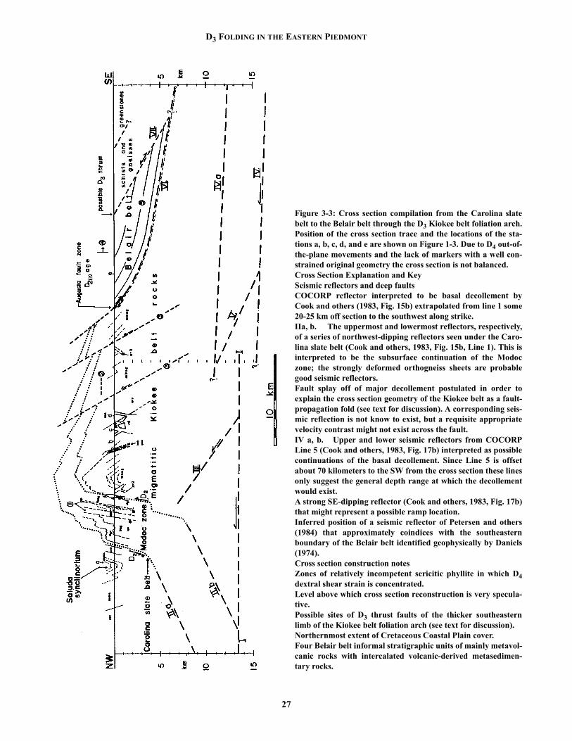
D3 FOLDING IN THE EASTERN PIEDMONT
27
Figure 3-3: Cross section compilation from the Carolina slatebelt to the Belair belt through the D3 Kiokee belt foliation arch.Position of the cross section trace and the locations of the sta-tions a, b, c, d, and e are shown on Figure 1-3. Due to D4 out-of-the-plane movements and the lack of markers with a well con-strained original geometry the cross section is not balanced.Cross Section Explanation and KeySeismic reflectors and deep faultsCOCORP reflector interpreted to be basal decollement byCook and others (1983, Fig. 15b) extrapolated from line 1 some20-25 km off section to the southwest along strike.IIa, b. The uppermost and lowermost reflectors, respectively,of a series of northwest-dipping reflectors seen under the Caro-lina slate belt (Cook and others, 1983, Fig. 15b, Line 1). This isinterpreted to be the subsurface continuation of the Modoczone; the strongly deformed orthogneiss sheets are probablegood seismic reflectors.Fault splay off of major decollement postulated in order toexplain the cross section geometry of the Kiokee belt as a fault-propagation fold (see text for discussion). A corresponding seis-mic reflection is not know to exist, but a requisite appropriatevelocity contrast might not exist across the fault.IV a, b. Upper and lower seismic reflectors from COCORPLine 5 (Cook and others, 1983, Fig. 17b) interpreted as possiblecontinuations of the basal decollement. Since Line 5 is offsetabout 70 kilometers to the SW from the cross section these linesonly suggest the general depth range at which the decollementwould exist.A strong SE-dipping reflector (Cook and others, 1983, Fig. 17b)that might represent a possible ramp location.Inferred position of a seismic reflector of Petersen and others(1984) that approximately coindices with the southeasternboundary of the Belair belt identified geophysically by Daniels(1974).Cross section construction notesZones of relatively incompetent sericitic phyllite in which D4dextral shear strain is concentrated.Level above which cross section reconstruction is very specula-tive.Possible sites of D3 thrust faults of the thicker southeasternlimb of the Kiokee belt foliation arch (see text for discussion).Northernmost extent of Cretaceous Coastal Plain cover.Four Belair belt informal stratigraphic units of mainly metavol-canic rocks with intercalated volcanic-derived metasedimen-tary rocks.

HARMON D. MAHER
zone is approximately 6 km wide. An average finite shearstrain of 5 results. For φ = 20° the stretch (final over originallength) of lithologic unit thickness is 0.37; for φ = 5° thestretch is 0.69. Final angles of discordance (φ′) are 7.4° and3.5° in these respective cases. However, much of the discor-dance between Carolina slate belt lithologic units and theModoc zone (Fig. 1-2) is attributable to D2 strain. D4 strainwithin the study area seems to occur within the Modoc zone,is subparallel to map contacts, and not to transgress it. Theangle of discordance, although difficult to estimate, must befairly low. In conclusion, D4 could account for a significantproportion of the limb thinning, but an initial discordancebetween the Modoc zone and D4 shear zone strain bound-aries of close to 18° is necessary to explain all of it. Thisseems unlikely.
A second explanation lies in the mature of the surfacesbeing used to gauge Kiokee belt anticlinorium limb thick-ness. Simply, limb thickness is taken as the distance in crosssection measured in a direction perpendicular to the averagefoliation dip from the fold crest to the Modoc line on the NWside, and from the crest to the August fault zone on the SEside (Fig. 3-3). An implicit, underlying assumption inexpecting roughly equal limb thickness would then be thatthese surfaces (the Modoc zone and Augusta fault zone)were subhorizontal and are the same surface. Both theseassumption are possibly in error.
Substantial differences exist between the August faultzone and Modoc zone, even though both do separate high-grade, migmatitic Kiokee belt rocks from low-grade, Pre-cambrian to Cambrian slate belt rocks and are thought to bebroadly contemporaneous (both Alleghanian). The Augustfault zone is much thinner (several hundred meters versus 6kilometers). The granitic intrusives in the August fault zoneare invariably high strained and concordant. Finally, andmost importantly, the sense-of- shear textures in the twozones gibe directions and senses incompatible with being thesame ductile shear zone simply folded by D3. The two duc-tile shear zones are likely different surfaces and this interpre-tation is depicted in Figure 3-3.
An assumption that the Modoc zone and August faultzone were subhorizontal in a pre-D3 position might followfrom the observation that they are subparallel to metamor-phic isograds, and by inference to paleoisotherms, both ofwhich are easily envisioned as originally subhorizontal.However, isotherms are mobile with time, and if related toan intrusion front and involved in ductile faulting, as they arehere, there is no reason a significant original dip could notexist. Indeed, analysis of D2 structures (Sacks and Dennis,this vol.) suggests a Carolina slate belt, hanging wall-downcomponent for the Modoc zone, with an original dip of thezone shallowly to the northwest. A northwest-dipping sur-face being folded over a deeper flat- lying detachment sur-face would form an asymmetric foliation arch with a thinner,northwest limb and thicker southeast limb.
28
A third, intriguing explanation for the disparity of limbthickness is that cryptic D3 thrusts may exist within thesoutheast limb, resulting in a greater width. This would beconsistent with the convergent nature of D3. Some candi-dates exist for the location of such thrusts (Fig. 3-3). A rathersharp and continuous contact (otherwise rare in the migmati-tic Kiokee belt core) between a two-mica sillimanite schistand a variety of paragneisses is one possibility. Another can-didate is a zone where dips change fairly abruptly from 30-40°SE to 55-65°SE. The existence of these faults is admit-tedly speculative. Map scale F3 folds would also produce anapparently thicker southeast anticlinorium limb in a similarway to that ascribed to the thrust faults above. The zones ofsteep dip may thus be overturned F3 limbs. However, associ-ated hinge zones have not been observed.
Two sets of equivalent lithologic map units may exist onthe foliation arch limbs. The first set are two belts of pods ofultramafic rocks, the northern one of which is much thinnerthan the southern (Burks Mtn. Belt). The disparity in thick-ness may be due to D2 strain (Paul Sacks, pers. comm.). Thetwo belts are almost equidistant from the arch crest. The sec-ond correlation is more speculative, but the thick sillimaniteschists midway on the southeast limb (just under one of theinferred thrust faults discussed above) could represent ahigher grade version of the pelitic portion of the Asbill Pondformation phyllites and sericitic quartzites seen within theModoc zone on the northwest limb.
D3 FOLDING AND CRYSTALLINE THRUST SHEETS
Secor and others (1986b) interpret the Kiokee and Char-lotte belts each as “a D3 ramp antiform which developed dur-ing northwestward translation of the crystalline thrust sheet”(p. 1350). COCORP data (Cook and others, 1980) suggeststhe decollement for the eastern Piedmont crystalline thrustsheet lies in the 12 to 15 km depth range, and regional rela-tions suggest a minimum of 175 km of transport on the dec-ollement (Secor and others, 1986b).
The geometry of a ramp antiform is controlled by theheight and dip of the ramp and by the amount of offset.Ramp antiforms where all of the hanging wall cut-off hasmoved off the ramp and onto the flat develop a flat top. Withincreased transport the flat top grows in width in direct pro-portion to fault displacement. Whereas the Charlotte belt hasan appropriate flat top to be a ramp antiform the Kiokee beltdoes not. The fairly sharp crest of the Kiokee belt suggestseither: 1) a limited amount of movement (equal to or lessthan ramp length), which is inconsistent with a direct associ-ation with the basal major decollement, or 2) suggests analternate geometry. A fault-propagation fold (Suppe, 1985)can explain the observed asymmetry and sharp crest of theKiokee belt foliation arch, and it is this interpretation whichis depicted in Figure 3-3 (surface III).

D3 FOLDING IN THE EASTERN PIEDMONT
40AR/39AR DATA AND D3
Six 40Ar/39Ar dates on biotite separates from the Kiokeebelt in central South Carolina have a spread of 278 to 283Ma and a mean of 282 Ma (Dallmeyer and others, 1986).These ages are thought to reflect uplift and cooling throughthe 300 + 25° biotite Ar retention temperature (Jager, 1979;Harrison and others, 1985) during D3 thrusting and foldingof Kiokee belt rocks (Dallmeyer and others, 1986). Interest-ingly, Charlotte belt rocks have a range of ages from 251 to292 (n=15) and a mean of 271 Ma (Dallmeyer and others,1986).
If the Kiokee belt and Charlotte belt were both rampantiforms formed by transport over the same major basaldecollement, then it might be expected that the Charlotte beltwould have older (since it would have been formed bymovement over a higher ramp along the same detachmentsurface) or equivalent ages to the Kiokee belt. However, ifthe Kiokee belt is formed as a fault propagation fold over asplay then there is no constrained relative age relationshipbetween uplift in the two belts. Younger Charlotte belt agesmay merely reflect foreland migration of thrust movement.This is a speculative conclusion since all the dates from theKiokee belt are from the northwest limb and a complete sam-pling traverse does not exist as it does the Charlotte belt.Assuming the disparity of 10-20 Ma between hornblendeand biotite 40Ar/39Ar cooling ages (Dallmeyer and others,1986) represents the age of Alleghanian convergent relatedthrusting and folding throughout the southern Appalachians,a minimum estimate of shortening rate can be made. With aminimum shortening of 175 km documented (Secor and oth-ers, 1986b), a minimum rate of 0.875 cm/yr results – a ratecomparable with that observed in modern orogens. This esti-mate is based on limited data and a lot of assumptions, but itclearly shows the potential 40Ar/39Ar data has for furtherelucidating and constraining the history of thrusting in thePiedmont.
A COMPARISON OF D3 IN THE RALEIGH AND KIOKEE BELTS
Farrar (1985) describes a deformational chronology forthe easternmost Piedmont in North Carolina that includes aD3 event that is similar, in part, to D3 described here for theSouth Carolina eastern Piedmont. Farrar’s D3 includes twogroups of structures: 1) regional scale folds interpreted tohave been formed by late Alleghanian compression, and 2)three mylonite zones on the limbs of these major folds.
The following similarities exist between F3 in the twoareas: a) an open to tight, and microscopic to regional-scalefold geometry, b) an associated S3 that is approximatelyaxial planar to regional scale F3 folds, and c) an Alleghanianage. However, one substantial difference exists that is espe-cially significant to the discussion here. The largest F3 fold
29
in North Carolina, the Wake-Warren antiform with high-grade Raleigh belt rocks in the core, has a southeastwardoverturned limb in its northern portion, and a more uprightgeometry in its southern portion. If F3 regional scale folds ofNorth Carolina are related to emplacment of crystallinethrust sheets, as we propose they are in the guidebook area,then a different geometry must exist in the two areas. Asoutheast directed backthrust would be one possibility forthe Wake-Warren antiform.
Farrar (1985) also includes the Nutbush Creek, Maconand Hollister mylonite zones as part of D3. The NutbushCreek and Hollister mylonites have sense-of-shear indicatorssuggesting an important dextral movement component.These zones might be better equated to the D4 dextral eventwell documented in South Carolina (Secor and others,1986a; Dennis and Secor, 1987; Dennis and others, this vol-ume). Although it is likely that a continuum of deformationexisted between D3 and D4 the fact that they represent differ-ent kinematic regimes warrants their differentiation. In SouthCarolina D4 fabrics localized along the steep limbs of D3folds and therefore D3 is not completely coeval but musthave preceded D4.
SUMMARY AND DISCUSSIONSecor and others (1986b) suggest that the Kiokee belt
and Charlotte belt anticlinorium are ramp antiforms associ-ated with Alleghanian emplacement of crystalline thrustsheets. Geochronologic data (Dallmeyer and others, 1986),geophysical data (Cook and others, 1980; Petersen and oth-ers, 1984), and field studies can be used to further test anddevelop this basic model. With these considerations in mind,the Kiokee belt along the Savannah River is proposed to be alarge fault-propagation fold over the major Southern Appala-chian decollement.
To the southwest in Georgia, near Washington, theCarolina slate belt terminates (Anon, Georgia Geologic Sur-vey, 1976; Williams, 1978) in what may be NE-plunging F3folds and the Charlotte belt and Kiokee belt are adjoining.This is a critical spot for further elucidating the large scaleD3 crustal architecture. On a very speculative note, this areacould be the location of a lateral ramp. In any case the D3architecture changes along strike. Finally, 40Ar/39Ar datesfrom a sampling traverse across the Kiokee belt and into theBelair belt would provide valuable constraints in developingand testing such models. This work was supported by theUniversity of Nebraska, Omaha, and National Science Foun-dation grant EAR-8508184.
REFERENCES CITEDAnon, 1976, Geological map of Georgia: Georgia Geological Sur-
vey, 1: 500,000.Cook, F.A., Brown, L.D., Kaufman, S., and Oliver, J.E., 1983, The
COCORP seismic reflection traverse across the southern Appa-

HARMON D. MAHER
lacians: American Association of Petroleum Geologists Studiesin Geology, #14, 61 p.
Crickmay, G.W., 1952, Geology of the crystalline rocks of Georgia:Georgia Geological Survey Bulletin 58, 54 p.
Dallmeyer, R.D., Wright, J.E., Secor, D.T., Jr., Snoke, A.W., 1986,Character of the Alleghanian orogeny in the southern Appala-chians: Part II. Geochronological constraints on the tectono-thermal evolution of the eastern Piedmont in South Carolina:Geological Society of America Bulletin, v. 97, p. 1329-1334.
Dennis, A.J. and Secor, D.T., Jr., 1987, A model for the develop-ment of crenulations in shar zones with applications form thesouthern Appalachian Piedmont: Journal of Structural Geology,in press.
Farrar, S.S., 1985, Teconic evolution of the easternmost Piedmont,North Carolina: Geological Society of America Bulletin, v. 96,p. 362-380.
Harrison, T.M., Duncan, I., and McDougall, I., 1985, Diffusion of40Ar in biotite: Temperature, pressure and compositionaleffects: Geochemica et Cosmochimica Acta, v. 49, p. 2461-2468.
Jager, E., 1979, Introduction to geochronology, in Jager, E., andHunziker, J.C., eds., Lectures in isotope geology: Berlin,Springer-Verlag, p. 1-12.
Maher, H.D., Jr., 1979, Stratigraphy and structure of the Kiokee andBelair belts near Augusta, Georgia: Columbia, University ofSouth Carolina M.S. Thesis, 94 p.
Maher, H.D., Jr., 1987, Kinematic history of mylonitic rocks fromthe Augusta fault zone, South Carolina and Georgia: AmericanJournal of Science, in press.
Metzgar, C.R. 1977, The petrology and structure of the Edgefield7.5’ quadrangle, South Carolina Piedmont: Columbia, Univer-sity of South Carolina M.S. Thesis, 51 p.
Petersen, T.A., Brown, L.A., Cook, F.A. Kaufman, S., Oliver, J.E.,1984, Structure of the Riddleville Basin from COCORP seis-mic data and implications for reactivation tectonics: Journal ofGeology, v. 92, p.
Secor, D.T., Jr., Snoke, A.W., Bramlett, K.W., Costello, O.P., Kim-brell, O.P., 1986a, Character of the Alleghanian orogeny is thesouthern Appalachians: Part I. Alleghanian deformation in theeastern Piedmont of South Carolina: Geological Society ofAmerica Bulletin, v. 97, p. 1319-1328.
Secor, D.T., Jr., Snoke, A.W., Dallmeyer, R.D., 1986b, Character ofthe Alleghanian orogeny in the southern Appalachians: Part III.Regional tectonic relations: Geological Society of AmericaBulletin, v. 97, P. 1345-1353.
Suppe, J., 1985, Principles of Structural Geology: EnglewoodCliffs, New Jersey, Prentice Hall, Inc., 537 p.
Wegmann, C.E., 1935, Zur Deutung der Migmatite: GeologischeRundschau, v. 26, p. 305-350.
Williams, H., Jr., 1978, Tectonic lithofacies map of the Appalachianorogen: St. Johns, Newfoundland, Memorial University, Map,1:1,000,000.
30

CAROLINA GEOLOGICAL SOCIETYGuidebook for 1987 Annual Meeting
Pages 31-42
INTRODUCTIONAlong the fall line in North Carolina, South Carolina,
and Georgia, steeply dipping, dextral shear zones transectthe Alleghanian front of metamorphism and ductile deforma-tion at a small angle. These zones include the Hollister,Macon, and Nutbush Creek mylonites in North Carolina, theIrmo shear zone in South Carolina, and the Towaliga mylo-nites in Georgia (Fig. 4-1). By both radiometric methods andoverprinting relationships, these zones represent the last duc-tile deformation in Southern Appalachian Piedmont (Table1). This short contribution outlines the Irmo shear zone andits structures in the context of late Paleozoic strike slip defor-mation.
Recently Secor and others (1986a) have presented a
31
deformation chronology for the eastern Piedmont of SouthCarolina. Because we refer to this chronology throughoutthis report, we summarize it here. D1 or Delmar deformationis expressed as the slaty cleavage, S1, and greenschist faciesmetamorphism, M1, in the Carolina slate belt. The cleavageis axial planar to map-scale structures: the Delmar synclino-rium, Emory anticlinorium, and Saluda synclinorium. D1 isinterpreted to be pre-Alleghanian and may reflect the accre-tion of the Carolina arc to the ancient North American mar-gin. D2, or Lake Murray deformation, is the earliestrecognized Alleghanian (ca. 325 ma) deformation in theeastern South Carolina Piedmont. D2 is recognized asamphibolite facies metamorphism (M2) and deformation(S2) in the Kiokee belt. The Modoc zone defined by the gar-net isograd and the pervasive intrusion of orthogneiss sheets
NATURE OF THE LATE ALLEGHANIAN STRIKE-SLIP DEFORMATION IN THE EASTERN IRMO SHEAR ZONE
Allen J. Dennis and Paul E. SacksDepartment of Geological Sciences
The University of South Carolina, Columbia, S.C. 29208
Harmon D. MaherDepartment of Geography and Geology
The University of Nebraska at Omaha, Omaha, NE 68182-01999
Figure 4-1. Sketch map of southern Appalachians showing the distribution of documented Alleghanian strike slip faulting (italics)relative to the Blue Ridge Fault and the Cumberland Plateau.

Allen J. Dennis AND OTHERS
marks the northwestern limit of D2. As S1 is not recognizedin the Kiokee belt, neither is S2 recognized in the Carolinaslate belt. Clarks Hill deformation or D3 upright foldingabout axes shallowly plunging to the east is responsible forthe alternating low and high grade belts in the Carolinas: theBelair, Carolina slate, and Kings Mountain belts are exposedas synclinoria, while the Kiokee, Raleigh, Charlotte andInner Piedmont belts are antiformal cores of deeper-seatedmetamorphism. 40Ar/39Ar hornblende and biotite mineralages (Dallmeyer and others, 1986) support the hypothesisthat uplift of high grade belts in the metamorphic core of theorogen accompanied crustal shortening and folding andthrusting in the Valley and Ridge. Secor and others (1986b)have suggested that belt boundaries may be interpreted asapproximating the strikes of mid-crustal ramps of theAlleghanian decollement, and that the high grade belts areexposed as ramp antiforms. While mesoscopic F3 and L1x3are common in the Carolina slate belt, rarely is a mesoscopiccleavage apparent. The Kiokee and Irmo antiforms and the
32
Lexington synform are map-scale expressions of the D3 inthe eastern Piedmont of South Carolina. Finally D4, or Irmodeformation, dextral shearing overprints some of the subver-tical belt boundaries. Strike slip displacements are typicallysmall, on the order of 10 km, and shear strains averagedacross the width of the zones are also small, on the order of 1to 2.
In this report the Irmo shear zone is defined to be anapproximately 10 km wide zone of heterogeneous ductiledeformation which refolds the core of the D3 Irmo antiformin a dextral sense, and those splays off the main zone, forexample in the Clouds Creek complex (Fig. 4-2). The Irmoshear zone has been mapped from Blythewood and Ridge-way north of Columbia (Dennis, 1985), to Leah, Georgia andwest into northern Warren County, Georgia (Crawford,1968). Along its entire exposed length, the Irmo shear zoneappears to be localized near and overprinting the Modoczone (see Sacks and Dennis, this volume). Hatcher and oth-ers (1977) defined the eastern Piedmont fault system on the
Table 1. Compilation of geochronology of Southern Appalachian Alleghanian strike slip zones.
ZONE CUTS FABRIC AGE
Brevard Palmetto granite ca. 325, U/Pb zircon1
Ben Hill granite ca. 325, U/Pb zircon1
?
Brookneal Melrose granite 512±5, U/Pb zircon2
fabric in Arvonia fm. 324±3, 40Ar/39Ar hbd3300±5, Rb/Sr biot, w.r.2
Hollister Butterwood Creek granite 292±13, Rb/Sr w.r.4 251, Rb/Sr biot, w.r.4
Irmo Batesburg augen gneiss 291±4 , Rb/Sr w.r.5
Batesburg lineated gneiss 284 ±17, Rb/Sr w.r.5
Lexington metagranite 292±15, Rb/Sr w.r.6
Clouds Creek granite 319 ± 27, Rb/Sr w.r.6 Clouds Creek granite 240 ±75, U/Pb zircon7
amphibolite fabric, 315-295, 40Ar/39Ar7
268±5, 40Ar/39Ar biot7
Kings Mountain High Shoals granite 317, U/Pb zircon8
amphibolite fabric 318-323, 40Ar/39Ar8
?
Macon amphibolite fabric ca. 300, 40Ar/39Ar 3 ?
Nutbush Creek Buggs Island granite 313±8, Rb/Sr w.r.9
Wilton granite 285±10, Rb/Sr w.r.6
Lillington granite 290, Rb/Sr w.r.9
?
Towaliga High Falls granitic gneiss ca. 325, U/Pb zircon10
amphibolite fabric, ca. 36511
?
1 Higgins and Atkins, 19812 Gates and others, 19863 Glover and others, 19834 Russell and others, 19855 Snoke and others, 19806 Fullagar and Butler, 19797 Dallmeyer and others, 19868 Horton and others, 19879 Kish and Fullagar, 197810R.L. Atkins, personal communication11Russell, 1976

LATE ALLEGHANIAN STRIKE-SLIP DEFORMATION -- EASTERN IRMO SHEAR ZONE
33
Figure 4-2. Structural geology of the Irmo shearzone. Shear pattern, rocks containing Irmo crenula-tions; Stipple pattern, Kiokee belt; Oriented linepattern, deformed Carboniferous granitic rocks;Isotropic line pattern, undeformed Carboniferousgranitic rocks. Axial traces of major D1 foldsshown. D4 structures in previously foliated rocks

Allen J. Dennis AND OTHERS
basis of a continuous, linear, geophysical signature coinci-dent with known exposures of mylonitic rocks along the fallline. They suggested that the Nutbush Creek mylonite repre-sented a northward continuation of the Modoc zone. Map-ping by Druhan and Rollins (1984), Bartley and others(1984), Farrar (1985), and Horton and others (1986) has sub-stantiated this correlation. Based on the coincidence of theIrmo shear zone with the Modoc zone, the Irmo shear zone isinferred to continue southwest to at least Sparta, and northtowards North Carolina and the Nutbush Creek mylonite.
The other late Alleghanian strike slip zones also reacti-vate pre-existing crustal weaknesses defined by thermal con-trasts, faulting or both. In North Carolina, the Nutbush Creekmylonite (Casadevall, 1977) on the western side of theRaleigh belt reactivates the contact of the Falls Lake terrane,interpreted to be a tectonic melange by Horton and others(1986), with the Raleigh block, in a dextral strike slip sense.The Nutbush Creek mylonite outcrops within 5 km west ofFarrar's (1985) D2 decollement between allochthonous Caro-lina terrane lithologies and the Proterozoic Raleigh blockwithin the Raleigh belt. The Nutbush Creek mylonitediverges from the folded D2 decollement south of Raleigh,and continues southwest towards Hartnett County (Casade-vall, 1977). The Hollister and Macon mylonite zones outcropon either side of the folded D2 decollement on the easternside of the Raleigh belt.
The Macon and Hollister mylonites are interpreted byFarrar (1985) to be related to F3 (his notation) Alleghanianfolding about a shallowly plunging axis. Farrar's cross sec-tions suggest that 1) mylonitization is related to attenuationalong the limbs of major F3 structures - the Spring Hope syn-form to the east and the Wake-Warren antiform to the west;and 2) folding in the mylonites is parasitic on the F3 folds.However, kinematic indicators show that mylonitization wascontemporary with dextral strike slip movement. Boltin andStoddard (1987) recognized asymmetric tails on porphryo-clasts in felsic orthogneisses deformed by the Macon mylo-nite (their fig. 3), that suggest dextral movement. TheHollister mylonite is another D3 structure, on the easternflank of the Raleigh belt, in fact, separating the Raleigh beltfrom the eastern slate belt. Mylonitic textures in the Butter-wood Creek pluton include dextral S-C fabrics and asym-metric, recrystallized tails on feldspar augen indicatingdextral shear. Farrar (1985) and Boltin and Stoddard (1987)have noted the subhorizontal biotite mineral lineation whichparallels the trend of the Hollister zone. Unfortunately theHollister zone becomes less mappable in the metavolcanicand metasedimentary terranes to the south.
The Nutbush Creek, Macon, Hollister and Irmo shearzones are associated spatially, if not genetically, with leuco-cratic orthogneisses: the Falls leucogneiss, the Bens Creekleucogneiss, the unnamed leucogneiss of Boltin and Stod-dard (1987), and the Modoc zone orthogneisses, respec-tively. Indeed, Secor and others (1986a), Farrar (1985) and
34
Boltin and Stoddard (1987) all consider these orthogneissesto be D2 structures. In North Carolina, the orthogneisses aregenetically related to decollement and thrusting of the volca-nogenic Carolina terrane over the Raleigh block basementcomplex. In South Carolina, they are considered related tothe down-to-the-north shear zone origin of the Modoc zone.Incidentally, while Farrar (1985) and Sacks and Secor (1986)disagree on the mechanism of the earliest Alleghanian defor-mation, both models recognize the same shear sense acrossearly pre-thermal peak shear zones. This suggests to us thestrong case for reactivation of early, fundamental features inthe Piedmont as strike slip zones, particularly as they arefolded into subvertical orientations by D3 ramp folding assuggested by Secor and others (1986a,b) and Horton andothers (1987).
The Towaliga mylonites may be correlative with theKings Mountain shear zones recognized by Horton (1982),by way of the Middleton-Lowndesville zone (Griffin, 1970)and the Hartwell extension to the Towaliga fault, proposedon the State Geologic Map of Georgia, 1976. Interpretingseismic reflection data in the context of the geologic map-ping presented by Schamel and others (1980), Nelson andothers (1985) confirmed that the Towaliga fault representeda post-thrusting, normal fault dipping steeply towards theforeland. On the basis of the seismic data, Nelson and others(1985) interpreted a 7 km normal offset of the decollementon the Towaliga, with the Pine Mountain belt in the footwalland Piedmont in the hangingwall. In detailed shear sensestudies of the Towaliga mylonites, Hooper and Hatcher(1988) present data that indicates subhorizontal, dextralmovement on the fault. This suggests that if the Towaligamylonites formed as a post-thermal peak, post-thrusting nor-mal fault, then subsequently, they were reactivated as a strikeslip fault in later Alleghanian time. Gates and others (1986)have correlated the Brookneal mylonite zone, on the westernflank of the Carolina terrane, in the vicinity of the CentralPiedmont Suture with the Kings Mountain shear zones ofHorton (1982).
1) The Irmo, Nutbush Creek, Macon, and Hollisterzones, 2) the Towaliga, Kings Mountain, and Brooknealzones, and 3) the Brevard zone (Bobyarchick, 1984, andVauchez, 1987) define three roughly parallel linear zones ofAlleghanian strike slip deformation. All of these zones seemto be related to earlier tectonic boundaries that, with theexception of the Towaliga, have been rotated into a subverti-cal orientation by Alleghanian ramp folding and reactivatedas strike slip faults. The approximately 100 km across strikespacing of these zones may offer clues to the spacing ofthese major ramps. Within the limits of error of the availabledating methods, the zones are contemporary with each otherand with continuing deformation in the foreland (see espe-cially Secor and others, 1986b).

LATE ALLEGHANIAN STRIKE-SLIP DEFORMATION -- EASTERN IRMO SHEAR ZONE
THE IRMO SHEAR ZONE The Irmo shear zone affected foliated and unfoliated
rocks under upper greenschist facies conditions in the period291-268 Ma. The Irmo shear zone cuts para- and orthog-neisses of the Kiokee belt, the previously unfoliated Bates-burg augen and lineated gneisses, the Clouds Creek complexand the Lexington metagranite, and the foliated, greenschistfacies metasediments and metavolcanics of the Carolinaslate belt. Interpretation of map pattern suggests approxi-mately 10 km of subhorizontal displacement over a 10 kmwide zone of heterogeneous deformation. Because the Irmoshear zone cuts a variety of rock types which were both wellfoliated and unfoliated, many different mesoscopic shearsense indicators are recognized within it. We have definedthe boundaries of the Irmo shear zone using the outcrop dis-tribution of these mesoscopic structures and the interpretedrefolding of units by the shear zone.
In the Kiokee and Carolina slate belts, composite planarfabrics yield consistent, dextral shear sense. Reverse andnormal slip crenulations deform S1 and S2 foliations. In theCarolina slate belt F3 fold axes and L1x3 lineations are recog-nized folded by F4 reverse slip crenulations. Reverse andnormal slip crenulations are structures common to many
35
sheared anisotropic rocks (Fig. 4-3). Reverse slip crenula-tions are rootless, intrafolial folds of foliation with the samevergence as the shear zone. The rootless aspect of these foldsis typically controlled by microfaults subparallel to theiraxial planes that root in foliation surfaces. They are inferredto form as a consequence of slip on foliation when that folia-tion is inclined at a clockwise acute angle to the shear zonewall (Fig. 4-4a). Normal slip crenulations offset the foliationin a normal sense, consistent with the shear sense of thezone. Normal slip crenulations are inferred to form when aslipping foliation is oriented at a clockwise obtuse angle tothe shear zone wall (Fig. 4-4b). Displacement sense is con-sistent on slipping foliation and crenulation surfaces and theshear zone as a whole. Elsewhere we have presented the casefor considering RSC and NSC as mechanisms to conservethe shear zone’s width and orientation when slip on a folia-tion inclined to zone boundaries is an important mode ofdeformation in the zone (Dennis and Secor,1987a).
Several lines of evidence support this interpretation: 1)RSC and NSC are best developed in strongly anisotropicrocks, whether that anisotropy is a compositional layering(Asbill Pond formation laminated siltstone) or a foliation(Persimmon Fork Formation metavolcanics or foliatedClouds Creek complex). 2) RSC and NSC are best devel-
Figure 4-3. Field sketches of reverse and normal slip crenulations, from the south side of Lake Murray and the Ridge Road buttonschist zone, respectively.

Allen J. Dennis AND OTHERS
oped when the foliation is oriented within 5° of the shearzone wall. 3) RSC and NSC planes commonly root in slip-ping foliation. 4) RSC and NSC are best developed in rocksdeformed under conditions that enhance the mechanicalanisotropy, i.e., greenschist facies in quartz-mica schists. 5)Mineral lineations interpreted to be stretching or transportlineations are normal to crenulation axes. 6) Slip on RSC andNSC surfaces may be recognized as marker horizons are off-set along crenulation surfaces (Fig. 4-5). 7) Angular rela-tionships between crenulations, foliations and the shear zonewall are consistent.
The outcrop distribution of these crenulations may beexplained by the reorientation of S1 and S2 surfaces duringD3 time, and the reactivation of those foliations as slip sur-faces in D4 time. Because the Irmo shear zone transects theF3 Irmo antiform, RSC4’s are formed north-northeast of theof the core of the map-scale D3 fold as the S1 and S2 folia-tions are folded into the “overturned” limbs of the D3 struc-tures (Irmo Northeast Domain). As the S1-S2 foliations arefolded about the D3 axes over the map view “crest” of theIrmo antiform, they are reoriented: S1 and S2 make an acuteangle, measured clockwise, from the inferred boundary ofthe Irmo shear zone (Fig. 4-4a). In the foliated rocks on the“trailing” limbs of these D3 folds, NSC developed becausethe orientation of the slipping foliation is obtuse when mea-sured clockwise from the inferred orientation of the Irmo
36
shear zone wall (Fig. 4-4b). In the previously unfoliated gra-nitic rocks deformed during D4, Irmo shear zone time,NSC’s developed because the foliation that developed, and isinferred to have slipped formed at a clockwise obtuse angle(≈15° to 45°) to the shear direction (Fig. 4-4c).
D4 structures in previously unfoliated rocks In the Kiokee belt, the Batesburg augen and lineated
gneisses and the Lexington metagranite are interpreted to bepost-D2, synkinematic intrusions. The fabric in this post-D2suite of granitic rocks is defined by a parallel alignment ofK-feldspar augen and biotite flakes, and locally a minerallineation of recrystallized quartz and feldspar material. Thefoliation is subvertical and has a strike of approximately 062.The lineation is subhorizontal within that plane. Within thatlineation, an oblique grain shape fabric indicates dextralshear (Lister and Snoke, 1985). Well developed core-mantlestructures on feldspar augen yield material for asymmetrictails on porphryoclasts; these asymmetric tails indicate dex-tral shear (Simpson and Schmid, 1984). The slightly retortshape of these recrystallized tails suggests that recrystalliza-tion proceeded under retrograde conditions at approximatelyan order of magnitude slower rate than the deformation(Passchier and Simpson, 1986) Additionally, augen frac-tured and offset along mineral cleavage planes indicate dex-tral shear sense. Quartz is not a matrix mineral in these
Figure 4. From Dennis and Secor, 1987a. Reverse and normal slip crenulations form so that the orientation and width of the shearzone is not changed when slip on foliation is an important mode of deformation in the zone. a) Reverse slip crenulations form theslipping foliation is oriented at an acute clockwise angle to the shear zone boundary. b) Normal slip crenulations form when that slip-ping foliation is oriented at an obtuse clockwise angle to the shear zone boundary. c) When an isotropic rock develops a foliation, andthat foliation begins to slip, normal slip crenulations form, because according to all models of foliation formation, that foliation willform at an obtuse clockwise angle to the shear zone wall.

LATE ALLEGHANIAN STRIKE-SLIP DEFORMATION -- EASTERN IRMO SHEAR ZONE
granitic gneisses, so the orientation of a quartz crystallo-graphic fabric may not be used as a shear sense indicator,though it has been tested.
North of the Modoc zone, a prominent splay of the Irmoshear zone cuts an up-to-3 km thick swath oriented at aboutN50E through granitic rocks of the Clouds Creek complex.Within this splay, foliation is variably developed, and locallynormal slip crenulations deform this foliation. Again, folia-tion is defined by the parallel alignment of augen and biotiteflakes and is typically penetrative only to the mesoscopicscale. Fracture patterns and asymmetric tails on feldsparaugen suggest dextral movement. Normal slip crenulationsare defined by discontinuous surfaces of biotite spaced atirregularly wider increments than foliation, into which thatfoliation is deflected. While the biotite flakes defining crenu-lation surfaces do appear shredded, they are typically not ret-rograded to chlorite.
The apparent back-rotation of foliation in but-ton schists
In the sheared pelitic rocks of the Irmo shear zone, folia-tion is consistently penetrative to the microscopic scalewhile crenulations are penetrative only to the mesoscopicscale. In our interpretation, this helps to explain the apparentback-rotation of foliation between crenulation surfaces in
37
button schists (Dennis and Secor, 1987b). Foliation slip mayrotate crenulation planes, but crenulation slip, because itoccurs on planes penetrative to the mesoscopic scale, canonly translate foliation packets relative to one another.Therefore, in the case of NSC, as foliation slip progresses,the angle between NSC and foliation is expected to increase,while in the case of RSC, the angle the axial plane of thecrenulation makes with the foliation is expected to decrease,resulting in highly appressed RSC folding, and an exagger-ated intrafolial aspect (Fig. 4-6). Recognizing this effect insheared pelitic schists suggests that in a plane normal tocrenulation axes, the shear strain of lines parallel and per-pendicular to foliation prior to deformation, as a result of slipon foliation surfaces, may be estimated by recognizing therotation of crenulation surfaces by foliation slip.
Figure 7 presents angular relationships between NSCand foliation at sites where NSC was measured, and RSCand foliation in the Irmo shear zone. Often the shear strainacross a crenulation surface may be estimated by recogniz-ing the amount some marker, e.g., intrafolial quartz segrega-tions, has been displaced across the crenulation (Fig. 4-5). Ifthe angular relationship between the crenulations and thefoliations they deform can be calibrated to shear strain acrossfoliation, then we will have described the contributions ofslip on foliation and crenulation to the overall shear strain of
Figure 4-5. Using a foliation parallel quartz vein offset by slip on crenulation to estimate shear strain of lines parallel and perpendic-ular to crenulation, in a plane normal to crenulation axes. In this sample from the Ridge Road zone, assuming that the quartz vein isparallel to foliation surfaces (a) and that it is the same quartz vein that we see deflected across at least two NSC surfaces (a'), then wecan estimate the shear strain due to slip on crenulation, using the relation-ship g = cot a - cot a': cot(19°) - cot(42°) = 1.8. So the shearstrain of lines parallel and perpendicular to crenulation in the plane normal to crenulation axes due to crenulation slip is about 1.8.

Allen J. Dennis AND OTHERS
the zone.The results presented here are preliminary. Field evi-
dence and the model suggest the RSC’s initiate at an angle ofÝ 50-60° to the foliation they deform, and as that foliationcontinues to slip, are rotated to within 20-30° of that folia-tion. Following Ramsay (1967, equation 3-71, also his fig. 3-24, p.88), the slip on foliation required to effect this rotationis calculated to be in the range g =1.3 to 2.0 (Fig. 4-6). Simi-larly, NSC is interpreted to initiate at an angle of 150-140° tothe slipping foliation. This observation is in agreement withdata presented by Boyer (1984) and Casas (1986). With pro-gressive simple shear along that foliation, the NSC is rotatedto an angle of 120-110° with that foliation. Again, modellingthe slip on foliation as a homogeneous simple shear alongfolia surfaces, the finite shear strain along folia required toeffect this rotation of NSC is in the range 0.5 to 1.4. That theangle NSC makes with its foliation can be rotated by such a
38
small foliation slip shear strain may explain the apparentlymore normal, less skewed distribution of the NSC angle his-togram. Furthermore, the apparent back rotation of foliationslip surfaces in button schists may be enhanced by the devel-opment of a penetrative fabric, as a consequence of a simpleshear acting parallel to the boundaries of the zone, whichwill rotate NSC surfaces clockwise more rapidly than thefoliation they crenulate. In any case, it seems reasonable toconsider the shear strain of lines parallel and perpendicularto foliation, in a plane normal to crenulation axes, to beapproximately equal to 1. This seems in good agreementwith finite shear strains of 1 to 2, recognized by displacedmarker horizons, for lines parallel and perpendicular tocrenulation, in the plane normal to crenulation axes. Thissuggests that the contribution of foliation and crenulationslip shear strains to the overall shear strain of the Irmo shearzone is probably less than g = 3. This is consistent with shear
Figure 6. Because foliation, and therefore foliation slip, is penetrative to a finer scale than crenulation, finite slip on foliation sur-faces, modelled by us as a simple shear, rotates crenulation surfaces relative to foliation, and early angular relationships are not pre-served. Foliation slip shear strain may be estimated by the rotation of axial surfaces of crenulations. a) NSC surfaces’ angles withfoliation increase as a consequence of finite slip on foliation. b) RSC axial surfaces approach parallelism with foliation, as slip on thatfoliation continues.

LATE ALLEGHANIAN STRIKE-SLIP DEFORMATION -- EASTERN IRMO SHEAR ZONE
strain across the width of the zone of about 1, interpretedfrom the map pattern, or a dextral strike slip displacement ofabout 10 km.
In the vicinity of Clark Hill Lake, two subvertical zones
39
of button schist with traces of about N68E have been recog-nized. These are informally referred to as the Ridge Roadand Gundy Creek zones. An intense button schist fabric,defined by the intersecting NSC4 and the foliation, distin-
Figure 7. Angle-frequency histogram for the angle between foliation and crenulation for RSC (a), and NSC (b). c) The same dataplotted as a rose diagram with 10° petals normalized to a common foliation. Angle measure shown on the perimeter of the diagramfollows the convention drawn in Fig. 4-6. These graphs were prepared by calculating poles to foliation and crenulation at a givenlocation, taking the dot product of these poles, then calculating the Arccosine of the dot product, equal to the angle between the twopoles.

Allen J. Dennis AND OTHERS
guishes these zones which are developed primarily in quartzmica schists. Locally they contain RSC4 and conjugate NSC.Development of D4 crenulations is not restricted to thesezones, but the crenulated fabric is not typically developed sointensely outside of them. A third domain of less intenselydeveloped button schists is referred to as the Northern ClarksHill Domain. Two stops on this trip visit sites within theRidge Road and Gundy Creek zones (5 and 4). These sitesdemonstrate that with more intense NSC fabric develop-ment, the range of angles foliation makes with crenulationincreases, i.e. slipping crenulations continue to initiate as“more mature” ones, those with greater and greater angles,continue to evolve.
While this interpretation, that an increasing anglebetween NSC and foliation surfaces in pelitic schists repre-sents an increasing foliation slip shear strain, is perhapsunconventional (see Simpson, 1984, or Gates and others,1986), it is no less valid than a model that suggests that asmaller angle between foliation and crenulation planes repre-sents a higher shear strain. In contrast a more conventionalmodel predicts that with increasing shear strains, the anglebetween foliation (S) and crenulation (C) decreases (Bertheand others 1981, p.33-34). S is interpreted to initiate at 45° tothe zone boundary, and C is interpreted to initiate and remainsubparallel to the zone boundary. With progressive homoge-neous deformation, S is interpreted to track the XY plane ofthe finite strain ellipsoid, rotating towards C, until the twosurfaces are indistinguishable. Based on our mapping wehave several objections to this model: 1) crenulation surfacesoccur at finite angles to the mapped zone boundaries. 2) Inthe zones where normal slip crenulations are best developed,for example the Ridge Road and Gundy Creek zones in theClark Hill area, at any given outcrop a broad range of folia-tion crenulation angles are recorded from 20-30° up to 60-70°. 3) At sites where crenulations are developed, foliationslie within 10° of the interpreted zone boundaries. It is hopedthat the evidence in support of our hypothesis will leadworkers to consider it in their evaluation of shear strain increnulated pelitic schists. It is possible that both models arevalid under different conditions. We have here presented evi-dence that suggests that in sheared anisotropic rocks, withincreasing foliation slip the angle between foliation and nor-mal slip crenulations should increase.
CONCLUSIONS Along the fall line in the Southern Appalachians, a
record of late Alleghanian dextral strike slip reactivation ofearly Alleghanian and older features is preserved. Reactiva-tion was effected as the older features were rotated into steeporientations by ramp folding contemporary with folding andthrusting in the Valley and Ridge. The late Pennsylvanianand Permian ages of this strike slip deformation suggest thatit is a late stage, intraplate readjustment to collisional
40
stresses, and not generally a response to transpression or“tectonic escape.” Furthermore, while large scale strike slipmovement is well known in the Piedmont, the rotation ofearly flat-lying features, e.g., isograds, decollements, intosubvertical orientations documents the role of dip slip move-ments in the metamorphic core of the orogen.
In the eastern South Carolina Piedmont specifically, theIrmo shear zone overprints the Modoc zone. Nominally over150 km along strike and up to 10 km in width, the Irmo shearzone experienced about 10 km of dextral strike slip move-ment in the late Paleozoic. Overprinting relationships andgeochronologic studies confirm that this shearing was thelast ductile deformation in the Piedmont. Along its length theIrmo shear zone overprints previously unfoliated graniticrocks, well cleaved, greenschist facies metavolcanics andmetasediments, and amphibolite facies ortho- and parag-neisses. Many mesoscopic shear sense indicators are presentin these rocks, and they consistently show dextral shear.These mesoscopic structures include asymmetric, recrystal-lized tails on feldspar augen, fracture and sinistral offsetalong feldspar cleavage planes, and the development ofzone-orientation-and-width-preserving reverse and normalslip crenulations. Crenulation planes are steeply dipping, andaxes are steeply plunging. Subhorizontal mineral lineationsdeveloped in orthogneisses suggest strike slip transport, andsubgrains typically show an dextral, oblique grain shape fab-ric.
In this report, we have presented evidence that foliationslip shear strains may be estimated by looking at the anglecrenulation, penetrative to only the mesoscopic scale, makeswith microscopically penetrative foliation in shearedstrongly anisotropic rocks. Microscopically penetrative foli-ation slip will rotate normal slip crenulation planes so thatthe angle between foliation and crenulation increases withprogressive foliation slip. This results in apparently back-rotated foliation surfaces between crenulation planes. Simi-larly the angle between reverse slip crenulations and folia-tion deceases with progressive deformation, resulting in anincreasingly intrafolial aspect to these folds. A consequenceof this effect may be a misunderstanding of a region's defor-mation chronology, and an assignment of the most recentfolds to an “early isoclinal phase.” If the shear strain alongcrenulation surfaces may be estimated using offset markerhorizons, then contribution of foliation and crenulation slipsto the overall shear strain of the zone may be calculated.
ACKNOWLEDGEMENTSWe thank Don Secor for financial support over the
period when this work was done (National Science Founda-tion Grant EAR 8508123), and for our discussions of south-ern Appalachian geology. We thank Terry Dennis for herhelp and support. Maher acknowledges support from theUniversity of Nebraska, Omaha, and National Science Foun-

LATE ALLEGHANIAN STRIKE-SLIP DEFORMATION -- EASTERN IRMO SHEAR ZONE
dation grant EAR-8508184.
BIBLIOGRAPHYBartley, J.M., Turner, R.D., Mies, J., Druhan, R. and Butler, J.R.,
1984, Kinematic analysis of the Nutbush Creek mylonite zoneat Satterwhite Point, Kerr Lake, North Carolina, GeologicalSociety of America Abstracts with Programs, 15, 124.
Bobyarchick, A.R., 1984, A late Paleozoic component of strike slipin the Brevard zone, Southern Appalachians, Geological Soci-ety of America Abstracts with Programs, 15, 126.
Boltin, R. and Stoddard, E.F., 1987, Transition from eastern slatebelt to Raleigh belt in the Hollister quadrangle, North Carolina,Southeastern Geology, 27, 185-205.
Boyer, S.E., 1984, Origin and significance of compositional layer-ing in late Pre-Cambrian sediments, Blue Ridge Province,North Carolina, U.S.A., Journal of Structural Geology, 6, 121-133.
Casadevall,T., 1977, The Nutbush Creek dislocation, VanceCounty, North Carolina and Mecklenburg County, Virginia - aprobable fault of regional significance, Geological Society ofAmerica Abstracts with Programs, 9, 127-128.
Casas, J-M., 1986, Shear bands and related extensional structures ina mylonitized quartz dyke, Journal of Structural Geology, 8,693-699.
Crawford, T.J., 1968, Geologic Map of Warren County, Georgia,Central Savannah River Area Planning and Development Com-mission, Augusta.
Dallmeyer, R.D., Wright, J.E., Secor, D.T. and Snoke, A.W., 1986,Character of the Alleghanian orogeny in the southern Appala-chians. Part II. Geochronological constraints on the tectono-thermal evolution of the eastern Piedmont in South Carolina,Geological Society of America Bulletin, 97, 1329-1344.
Dennis, A.J., 1985, A model for the development of crenulations inshear zones with applications from the southern AppalachianPiedmont, University of South Carolina M.S. thesis, Columbia,21 p.
Dennis, A.J. and Secor, D.T., 1987a, A model for the developmentof crenulations in shear zones with applications from the south-ern Appalachian Piedmont, Journal of structural Geology, 9, inpress.
Dennis, A.J. and Secor, D.T., 1987b, An explanation for back-rotated foliations in button schists, Geological Society ofAmerica Abstracts with Programs, 19, 640.
Druhan, R.M. and Rollins, F.O., 1984, The Nutbush Creek FaultZone in the eastern Piedmont of North Carolina, GeologicalSociety of America Abstracts with Programs, 15, 135.
Farrar, S.S., 1985, Tectonic evolution of the easternmost Piedmont,North Carolina, Geological Society of America Bulletin, 96,362-380.
Fullagar, P.D. and Butler, J.R., 1979, 325 to 265 million year oldgranitic plutons in the Piedmont of the southern Appalachians,American Journal of Science, 279, 161-185.
Gates, A.E., Simpson, C. and Glover, L., 1986, Appalachian Car-boniferous dextral strike slip faults: An example fromBrookneal, Virginia, Tectonics, 5, 119-133.
Georgia Department of Natural Resources, 1976, Geologic Map ofGeorgia, Atlanta.
Glover, L., Speer, J.A., Russell, G.S., Farrar, S.S., 1983, Ages of
41
regional metamorphism and ductile deformation in the centraland southern Appalachians, Lithos, 16, 223-245.
Griffin, V.S., Position of the Kings Mountain belt in AbbevilleCounty, South Carolina, Southeastern Geology, 12, 105-113.
Hatcher, R.D., Howell, D.E. and Talwani, P., 1977, Eastern Pied-mont fault system: Speculations on its extent, Geology, 5, 636-640.
Higgins, M.W. and Atkins, R.L., 1981, The stratigraphy of thePiedmont southeast of the Brevard zone in the Atlanta, Georgiaarea, in Wigley, P.B. ed., Latest thinking on the stratigraphy ofselected areas in Georgia: Georgia Department of NaturalResources, Atlanta, 3-40.
Hooper, R.J. and Hatcher, R.D., 1988, Mylonites fron the Towaligafault zone, central Georgia: Products of heterogeneous non-coaxial deformation, Tectonophysics, submitted.
Horton, J.W., 1982, Shear zone between the Inner Piedmont andKings Mountain Belt in the Carolinas, Geology, 9, 28-33.
Horton, J.W., Sutter, J.F., Stern, T.W., Milton, D.J., 1987,Alleghanian deformation, metamorphism, and granite emplace-ment in the central Piedmont of the Southern Appalachians,American Journal of Science, 287, 635-660.
Horton, J.W., Blake, D.E., Wylie, A.S. and Stoddard, E.F., 1986,Metamorphosed melange terrane in the eastern Piedmont ofNorth Carolina, Geology, 14 551-553.
Kish, S.A. and Fullagar, P.D., 1978, Summary of geochronologicaldata for the late Paleozoic plutons from high grade metamor-phic belts of the eastern Piedmont of North Carolina, SouthCarolina, and Virginia, in Snoke, A.W. ed., Geological investi-gations of the eastern Piedmont, southern Appalachians: Caro-lina Geological Society 1978 Guidebook, South CarolinaGeological Survey, Columbia, 61-64.
Lister, G.S. and Snoke, A.W., 1984, S-C mylonites, Journal ofStructural Geology, 6, 617-638.
Nelson, K.D., Arnow, J.A., McBride, J.H., Willemin, J.H., Huang,J., Zheng, L., Oliver, J.F., Brown, L.D., Kaufman, S., 1985,New COCORP profiling in the southeastern United States. Part1: Late Paleozoic suture and Mesozoic rift basin, Geology, 13,714-718.
Passchier, C.W. and Simpson, C., 1986, Porphyroclast systems askinematic indicators, Journal of Structural Geology, 8, 831-843.
Ramsay, J.G., 1967, Folding and fracturing of rocks, McGraw-Hill:New York, 568p.
Russell, G.S., 1976, Rb-Sr evidence from cataclastic rocks forDevonian faulting in the southern Appalachians, GeologicalSociety of America Abstracts with Programs, 8, 1081.
Russell, G.S., Russell, C.W., and Farrar, S.S., 1985, Alleghaniandeformation and metamorphism in the eastern North CarolinaPiedmont, Geological Society of America Bulletin, 96, 381-387.
Sacks, P.E. and Secor D.T., 1986, Alleghanian down-to-the-northslip along the Modoc zone in the Appalachian Piedmont, Geo-logical Society of America Abstracts with Programs, 18, 737.
Schamel, S., Hanley, T.B. and Sears, J.W., 1980, Geology of thePine Mountain Window and adjacent terranes in the PiedmontProvince of Alabama and Georgia, Alabama Geological Soci-ety, University.
Secor, D.T., Snoke, A.W., Bramlett, K.W., Costello, O.P., and Kim-brell, O.P., 1986a, Character of the Alleghanian orogeny in thesouthern Appalachians. Part I. Alleghanian deformation in the

Allen J. Dennis AND OTHERS
eastern Piedmont of South Carolina, Geological Society ofAmerica Bulletin, 97, 1314-1328.
Secor, D.T., Snoke, A.W., Dallmeyer, R.D., 1986b, Character of theAlleghanian orogeny in the southern Appalachians. Part I.Regional tectonic relationships, Geological Society of AmericaBulletin, 97, 1345-1353.
Simpson, C. and Schmid, S.M., 1983, An evaluation of criteria todeduce sense of movement in sheared rocks, Geological Soci-ety of America Bulletin, 94, 1281-1288.
Simpson, C., 1984, Borrego Springs-Santa Rosa mylonite zone: alate Cretaceous west-directed thrust in Southern California,Geology 12, 8-11.
Snoke, A.W., Kish, S.A., Secor, D.T., 1980, Deformed Hercyniangranitic rocks from the Piedmont of South Carolina, AmericanJournal of Science, 280, 1018-1038.
Vauchez, 1987, Brevard fault zone, southern Appalachians: Amedium-angle, dextral, Alleghanian, shear zone, Geology, 15,669-672.
42

CAROLINA GEOLOGICAL SOCIETYGuidebook for 1987 Annual Meeting
Pages 43-63
NOTE: All field trip stops are on the following U.S.G.S. 7 1/2 minute quadrangles: Appling, Clarks Hill, Evans, Leah,Martinez, and Parkville.
Distance Cumulativebetween distancepoints (miles)
0.0 0.0 The road log begins at the lodge at HickoryKnob State Park on Clark Hill Lake nearMcCormick, SC.Proceed southeast along park road toward parkentrance.
3.8 3.8 Entrance to Hickory Knob State Park. Turnright and proceed southeast on SC-7 towardUS-378.
1.6 5.4 Junction SC-7 and US-378. Turn left on US-378and proceed east toward McCormick.
1.1 6.5 Bridge over Little River branch of Clark HillLake.
0.9 7.4 Entrance to Baker Creek State Park.3.7 11.1 Outcrop of felsic metatuff of the Carolina slate
belt on the left.0.1 11.2 Downtown McCormick. Intersection of US-378
with US-221/SC-28. Turn right and proceedsouth on US-221 toward Plum Branch. McCor-mick was a local center for gold mining duringthe 19th century.
4.8 16.0 Plum Branch. Turn left on SC-283, cross overrailroad tracks and proceed east through towntowards Stevens Creek.
2.0 18.0 STOP 1: Bridge over Stevens Creek. At thislocality we are in a band of felsic metatuff [Per-simmon Fork Formation(?); Figs. 1-2, 2-1]. Thebest exposure is just below the dam, in the creekbed, north of the highway bridge (Fig. 5- 1a).The rock here is a felsic crystal-lapilli tuff
43
(probably an ashflow). It has been stronglyoverprinted by static contact metamorphism thatpostdates the development of the tectonic fab-rics in the tuff. This contact metamorphism maybe related to the parent magma body which fedthe small mafic dikes that can be seen in theadjacent highway roadcuts. The primary fea-tures of the tuff and the secondary tectonic fea-tures are best seen on slightly weatheredsurfaces in the outcrop in the creek (Fig. 5-1b).The rock contains a strong foliation that isdefined by the plane of flattening of lapilli. Thisfoliation is interpreted to be at least in part pri-mary (S0) and due to collapse of pumice lapilliduring ashflow emplacement. This primary foli-ation may have been enhanced and/or trans-posed by subsequent tectonic strain. Carefulscrutiny of the creek outcrop reveals that thereare numerous mesoscopic folds varying fromopen to subisoclinal. These are interpreted tohave developed at various times during a pro-tracted D1 deformation. The tight folds have S1(c. N40oE 85oNW) as their axial surface. S1may be folded by some of the later more openfolds, and locally a weak second cleavage isdeveloped. The plunge and vergence of F1 foldsare variable.Except for the contact metamorphism, this rockis typical of the Persimmon Fork Formation (c.550-565 Ma) which outcrops widely in the slatebelt of central and western South Carolina. Thisparticular belt of Persimmon Fork is flanked onthe northwest and southeast by belts containingintermediate to mafic metavolcanic rocks, meta-mudstone, and metawacke in varying propor-tions (Figs. 1-2, 2-1). These flanking belts areinterpreted to be Richtex Formation in synfor-mal structures. The stratigraphic relationship
ROAD LOG FOR SATURDAY AND SUNDAY
NOVEMBER 14-15, 1987
Harmon D. MaherScott McIntyre
Department of Geography and GeologyThe University of Nebraska-Omaha, Omaha, NE 68182
Paul E. SacksDonald T. Secor, Jr.
Department of Geological SciencesThe University of South Carolina, Columbia, SC 29208

HARMON D. MAHER, Scott McIntyre, Paul E. Sacks and Donald T. Secor, Jr.
between the Richtex and Persimmon Fork isuncertain. Secor (this volume) favors an inter-pretation wherein the Richtex is allochthonousand the contact between the Richtex and Per-simmon Fork is an early syntectonic (D1) fault.Turn around and proceed west along SC-283 toPlum Branch.
2.1 20.1 Plum Branch. Turn left on US-221 and proceedsouth.
5.3 25.4 Parkville traffic light.
44
2.0 27.4 Modoc Speedway.0.3 27.7 Hamilton Branch State Park.1.7 29.4 Hutto's Sporting Goods. Turn left on SC-23 and
proceed toward Edgefield.1.3 30.7 Bridge over Stevens Creek.2.2 32.9 Turn left on national forest road 631. Proceed to
turn-around area at the end of the road, andpark.Follow footpath for several hundred feet down
Figure 5-1. a) Map from Parksville quadrangle (scale 1: 24,000) showing location of outcrop at Stop 1. b) Weathered vertical outcropface at Stop 1 showing lapilli and folds.
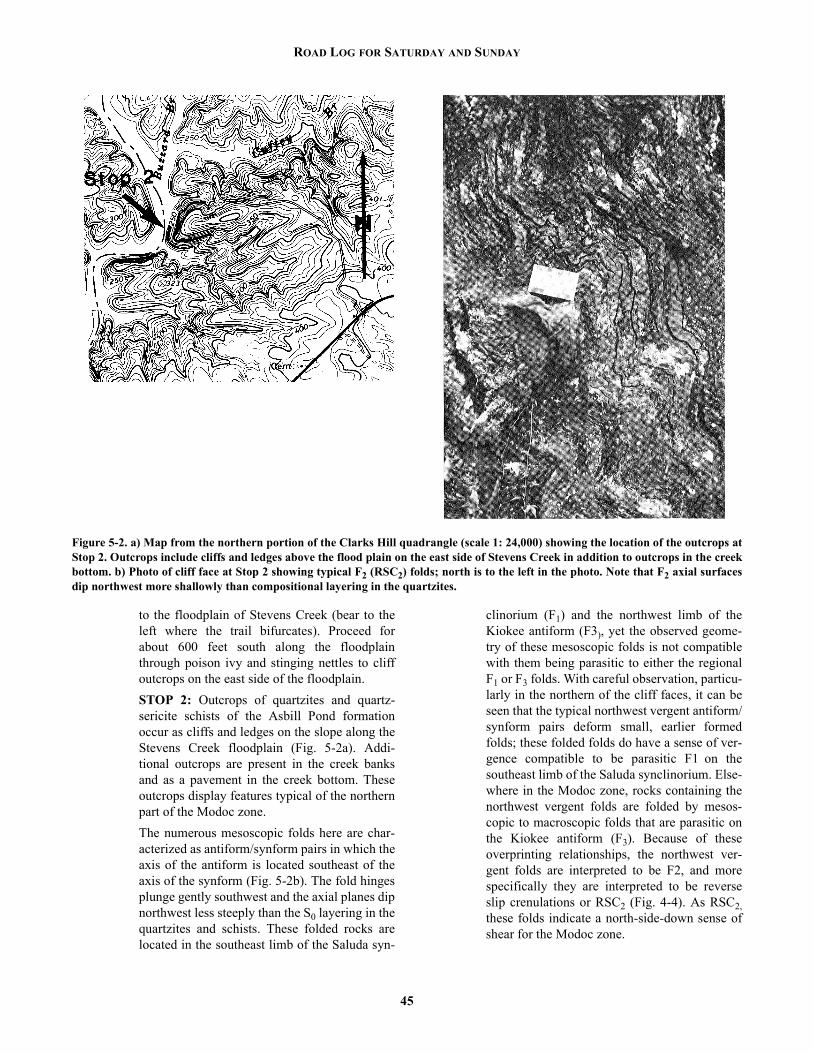
ROAD LOG FOR SATURDAY AND SUNDAY
to the floodplain of Stevens Creek (bear to theleft where the trail bifurcates). Proceed forabout 600 feet south along the floodplainthrough poison ivy and stinging nettles to cliffoutcrops on the east side of the floodplain.STOP 2: Outcrops of quartzites and quartz-sericite schists of the Asbill Pond formationoccur as cliffs and ledges on the slope along theStevens Creek floodplain (Fig. 5-2a). Addi-tional outcrops are present in the creek banksand as a pavement in the creek bottom. Theseoutcrops display features typical of the northernpart of the Modoc zone.The numerous mesoscopic folds here are char-acterized as antiform/synform pairs in which theaxis of the antiform is located southeast of theaxis of the synform (Fig. 5-2b). The fold hingesplunge gently southwest and the axial planes dipnorthwest less steeply than the S0 layering in thequartzites and schists. These folded rocks arelocated in the southeast limb of the Saluda syn-
45
clinorium (F1) and the northwest limb of theKiokee antiform (F3), yet the observed geome-try of these mesoscopic folds is not compatiblewith them being parasitic to either the regionalF1 or F3 folds. With careful observation, particu-larly in the northern of the cliff faces, it can beseen that the typical northwest vergent antiform/synform pairs deform small, earlier formedfolds; these folded folds do have a sense of ver-gence compatible to be parasitic F1 on thesoutheast limb of the Saluda synclinorium. Else-where in the Modoc zone, rocks containing thenorthwest vergent folds are folded by mesos-copic to macroscopic folds that are parasitic onthe Kiokee antiform (F3). Because of theseoverprinting relationships, the northwest ver-gent folds are interpreted to be F2, and morespecifically they are interpreted to be reverseslip crenulations or RSC2 (Fig. 4-4). As RSC2,these folds indicate a north-side-down sense ofshear for the Modoc zone.
Figure 5-2. a) Map from the northern portion of the Clarks Hill quadrangle (scale 1: 24,000) showing the location of the outcrops atStop 2. Outcrops include cliffs and ledges above the flood plain on the east side of Stevens Creek in addition to outcrops in the creekbottom. b) Photo of cliff face at Stop 2 showing typical F2 (RSC2) folds; north is to the left in the photo. Note that F2 axial surfacesdip northwest more shallowly than compositional layering in the quartzites.

HARMON D. MAHER, Scott McIntyre, Paul E. Sacks and Donald T. Secor, Jr.
Although F2 folds are the most prominent fea-tures present in this outcrop, other structures arealso present. Flat or gently sloping outcrop sur-faces display D4 normal slip crenulations(NSC4). It should be noted that both the NSC4and the foliation (DSF4) that is crenulated areoblique to the overall strike of the composi-tional layering that contains the crenulations.The foliation is always oriented at a small anglecounterclockwise from the strike of the layer-ing, and the crenulation is at a small angleclockwise from the strike of the layer; this rela-tionship indicates dextral strike slip. It is alsoworth noting that small markers (e.g. smallquartz veins) parallel to the foliation are offsetin a dextral manner by the crenulations.Although D4 crenulations like these are morepervasively developed elsewhere (see Stops 4and 5), the development of these textures here istypical of the style by which the Irmo shearzone overprints the Modoc zone.Follow national forest road 631 back out to SC-23.
2.0 34.9 Turn right on SC-23 and proceed towardModoc.
2.2 37.1 Bridge over Stevens Creek. Park just beyond thewest end of the bridge and walk west along SC-23 to powerline crossing. Walk south along thepowerline. At the first pole beyond the smallbrook, turn left and follow gully downhill tooutcrop along brook (Fig. 5-3a).STOP 3: The good-sized, unweathered, streampavement and bank outcrop at this locality is notuncommon in this area. Stream dissection oneither side of Steven's Creek and along GundyCreek in Clark Hill quad has downcut throughthe saprolitic cover to fresh bedrock. Mappingalong roads, which typically follow topographicridges where saprolitic cover is at its thickest,gives a false impression of outcrop quality inthis part of the Piedmont. Hence it is imperativewhen mapping in the Piedmont to walk all thestreams possible.The highly strained leuco-orthogneiss exposedat this locality is representative of many aspectsof the intrusive activity and deformation thatdefines, in part, the Modoc zone. The orthog-neiss here consists of quartz, plagioclase, andK-feldspar with 1% or less green-brown biotite,muscovite and opaque oxides. Common alter-ation minerals are epidote, chlorite and a veryfine-grained sericite. This outcrop locality
46
occurs within the northmost and largest (mapwidth of ≈ 1 km and minimum strike length of14 km) orthogneiss sheet within the Modoczone (Plate 1). Elsewhere in this same sheet agarnet-rich, muscovite orthogneiss and a biotiterich (1-2%) orthogneiss occurs. Either the sheetconsists of several intrusions of slightly differ-ent compositions or local contamination bycountry rocks has produced the compositionalvariations. Based on field observations, the gar-net muscovite orthogneiss is found adjacent tothe pelitic quartz-sericite (qs) unit (Plate 1) andthe biotite orthogneiss is usually found adjacentto biotite-amphibole gneisses. This correlationis suggestive of, perhaps, some contamination.The fabrics evident at this outcrop are a strong,subhorizontal, elongation lineation, a weakly tomoderately developed, steeply-dipping folia-tion, and local small folds of the foliation. Theelongation lineation is manifest as recrystallizedtails of quartz and feldspar with a central smallaugen of feldspar (Fig. 5- 3b). While commonlyan asymmetry to the augen tails is difficult todiscern, it is consistently dextral where apparent(e.g. east end of outcrop at this locality). Astrong subhorizontal, dextral elongation linea-tion would be consistent with D4 kinematics,but the evidence points to a D2 age. Map scaleF3 clearly fold some of the orthogneiss sheets(Plate 1) and hence the lineation was clearly D2or earlier. The extensive recrystallization ofquartz and feldspar is compatible with M2 peakmetamorphic conditions, but is incompatiblewith the low or sub-greenschist facies condi-tions of D4. The orthogneiss sheets were proba-bly relatively competent bodies by the time ofD4. D2 strain was partitioned into two compo-nents, and this elongation lineation (L2) in theorthogneiss is one - the other component isthought to reside in the paragneisses (Sacks andDennis, this vol.). Small folds of the orthogneissfoliation at the E end of the outcrop have a stylethat indicates they are RSC2 - these probablydeveloped late in the D2 strain history.Upstream and around the bend, outcrops ofbiotite-amphibole paragneiss occur. These aremapped as a country rock screen within theorthogneiss sheet (Plate 1). Screens of all sizesare common.Turn around and proceed east along SC-23.
1.1 38.2 Turn right on S-19-384.0.6 38.8 At “T” intersection turn right on S-19-139. Out-

ROAD LOG FOR SATURDAY AND SUNDAY
crop of Carboniferous orthogneiss on right.1.6 40.4 Bridge over Gundy Greek.
STOP 4: This location (Fig. 5-4a) containsgood exposures of three rock types: a sericitephyllite of the `button schist' zone; a thin bandof orthogneiss; and the biotite-amphibolegneiss. Outcrop is nearly continuous for morethan 100 meters downstream from the bridge(Fig. 5-4d). Similar stretches of outcrop occurfurther upstream and downstream.
47
Normal slip crenulations (NSC4) are well-developed in the `button schist'. Crenulationsare spaced two to four centimeters apart, and areoriented clockwise to the dominant slip foliation(alignment of micas). This unit also containsseveral tectonic inclusions: isolated small bod-ies composed primarily of alkali feldspar,quartz, and small tourmaline crystals. The inclu-sions are frequently elongate in the dominantslip foliation plane, and the size ranges from 5
Figure 5-3. a) Map from the north-central part of the Clarks Hill quadrangle (scale 1: 24,000) showing the location of the outcrop atStop 3. b) Subhorizontal pavement of orthogneiss with prominent L2. Note dextral sense-of-shear on some of the small augen.

HARMON D. MAHER, Scott McIntyre, Paul E. Sacks and Donald T. Secor, Jr.
Figure 5-4. a) Map from the eastern part of the Clarks Hill quadrangle (scale 1: 24,000) showing the location of outcrops in GundyCreek at Stop 4. b) Photo showing series of folds in biotite amphibole gneiss at Stop 4. The dextral overall fold sense coupled with amoderate plunge indicate these could be folds that formed in a D3 to D4 transition period. Location marked in central part of theoutcrop map. c) NSC-style foliation lozenge found along brittle fault in biotite amphibole gneiss. Location is marked in the south-western end of the outcrop map. d, next page) Outcrop map of Stop 5.
48

ROAD LOG FOR SATURDAY AND SUNDAY
49

HARMON D. MAHER, Scott McIntyre, Paul E. Sacks and Donald T. Secor, Jr.
to more than 40 centimeters. Thin, alkali feld-spar-rich layers exhibiting small dextrally-verg-ing folds occur in the southern portion of thebutton schist. These folds appear to plungesteeply to the northeast, and are probably F4 innature. (Erosion by the stream has produced asmooth, 2-dimensional surface; measurement ofactual plunge is not possible)The thinnest unit here is the orthogneiss. Com-posed primarily of alkali feldspar, micas, andsmall tourmaline crystals, this rock is foliated,crenulated and lineated. The lineation trendsN78E, plunges 16o, and is apparent as an elon-gation of minerals. In association with thecrenulations, numerous small faults, with dex-tral shear of the gneissic fabric, are present.Thin bodies of orthogneiss that extend into thebutton schist near the contact vary in thicknessfrom about 10 to more than 50 centimeters, andare up to three meters long.The biotite-amphibole gneiss comprises morethan half of the outcrop at this location. Theeffects of S2 deformation are manifested ascompositional layering and mineral alignmentin these rocks. Very thin, more felsic bandsalternate with thin mafic-rich layers, makingeven small folds easily visible (Fig. 5-4b).There appears to be a transition between F3 andF4 folds, evident by a continuous range of foldaxes oriented from horizontal to steeply plung-ing. In several places, shallowly-plunging F3fold surfaces have been refolded by steeper F4folds. F4 deformation here does not seem to besevere; F4 folds have produced wrinkles on theF3 folds, but have not obscured them.A brittle fault surface is present in the lowerportion of the outcrop. Small folds of composi-tional layers to the south of the fault are trun-cated, while layers to the north are concordant.Small quartz bodies are found along the faultsurface, as well as fine-grained chlorite. Minorantithetic faults to this brittle fault are present atsome places. Small, quartz-filled fractures, gen-erally perpendicular to compositional layering,are also found in this area. A large dextral NSCstructure is located along the fault (Fig. 5-4c).The effects of the various deformational epi-sodes are well-preserved in the rocks at thislocation. Textures in the 'button schist' are dom-inated by D4 structures, while the more compe-tent orthogneiss and biotite-amphibole gneissshow a superposition of D2, D3, and D4 struc-
50
tures.Continue south along S-19-139.
0.5 40.9 Turn right on S-19-143 and proceed towardClarks Hill.
3.0 43.9 Town of Clarks Hill. Cross railroad tracks andturn right on SC-28.
0.3 44.2 Turn left toward Clark Hill Dam on US-221.1.0 45.2 Visitors center, Clark Hill Dam (powerhouse
tours available).0.2 45.4 East end of Clark Hill Dam. As we travel across
the dam, you can see Burks Mountain and otherhills underlain by ultramafic rocks on the sky-line to the left.
1.1 46.5 West end of Clark Hill Dam.3.6 50.1 Turnoff to Petersburg Campground.2.1 52.2 Pollards Corner. Turn right and proceed north
on GA-104 toward Leah.2.3 54.5 Keg Creek Bridge. Migmatitic biotite amphib-
ole gneiss on right.1.8 56.3 Turn right on Ridge Road. Proceed east toward
Ridge Road Campground.4.4 60.7 Entrance to Ridge Road Campground.0.1 60.8 Turn left into boat ramp parking area. Numer-
ous outcrops are within walking distance.STOP 5: Lakeshore exposures of sericiticphyllite (sp), quartz-sericite schist (qs) andamphibolitic biotite amphibole paragneiss (bag)occur along the north side of the peninsula (Fig.5-5a). These rock units are some of the structur-ally lowest of rocks of Carolina slate belt affin-ity in the Modoc zone. Structures present inthese outcrops illustrate the effects of D2,D3,and especially D4. F2 folds with nearly hori-zontal hinge lines are present in the quartz-sericite schist and the biotite amphibole parag-neiss. Shallow northwest dips in the quartz-sericite schist are due to D3 folding. These rockunits here are also within the Irmo shear zoneand have a D4 crenulation fabric that overprintsto varying degrees the other structures. The D4fabric is most strongly developed in the sericiticphyllite (Fig. 5-5b) and is least developed in thebiotite amphibole paragneiss. The D4 crenula-tion fabric consists of a northeast striking, andsteeply dipping foliation (DSF4) that is crenu-lated by an approximately east-west striking,and steeply dipping normal slip crenulation sur-face (NSC4) (Dennis and Secor, 1987). Both ofthese D4 fabric elements (DSF4 & NSC4) are

ROAD LOG FOR SATURDAY AND SUNDAY
noticeably oblique to the zone boundaries (Plate1). Dextral strike slip is the sense of shear indi-cated by the NSC4.
The sericitic phyllite is well exposed at location5A. This unit of pervasively crenulated phyllite,like the crenulated phyllite unit at Stop 4(Gundy Creek) is traceable across the map areaof Plate 1. This rock weathers to form “but-tons,” and this rock is informally known as a“button schist.” Noteworthy features hereinclude the discontinuous nature of the NSC4surfaces, and the angular relationship betweenthe penetrative foliation and the spaced NSC4and the evidence of back rotation (Dennis andothers, this issue). Locally, tightly foldedquartzite veins or layers are present within thecrenulated phyllite. Typically, only fold hingesare present, but in some cases, fold vergencecan be determined. Some of the folds haveapproximately horizontal hinges and northwestvergence; these are probably RSC2. Other foldshave steeply plunging hinges and are dextral inplan view; these are probably RSC4.
The biotite amphibole paragneiss at 5B isamphibole rich. The rock at this part of the out-crop weathers to elongate, splintery or pencilshaped fragments. The fold hinges are typically
51
parallel to the long axis of the pencils. The longaxes of amphibole needles are in many cases,but not all cases, parallel to fold hinges. Thefolds are characteristically tight isoclinal foldswith highly attenuated or detached limbs.At 5C, outcrops of quartz-sericite schist exhibitthe overprint of the D4 crenulation fabric onolder structures. Here the interlayered quartzoseschist and sericitic quartzite have shallow tomoderate northwest dips. This is interpreted tobe due to the position of these rocks on the shal-low dipping part of an F3 fold. Note thatalthough DSF4 and NSC4 are present, they aremuch less developed here where foliation has ashallow dip than in the sericitic phyllite to thesouth. The D4 crenulation fabric is best devel-oped in steeply dipping limbs of F3 folds.A few small RSC2 are present in these rocks.These are difficult to find because of the over-print of D4 crenulations. These are most easilyfound by examining steeply northeast or south-west sloping outcrop faces.Turn around and proceed west along RidgeRoad toward GA-104.
4.5 65.3 Turn right on GA-104 and proceed to the north.0.5 65.8 Downtown Leah. Junction GA-104 and GA-47.
Figure 5-5. a) Map showing the location of the outcrops at Stop 5 in the eastern part of the Leah, GA quadrangle (scale 1: 24,000).5A shows the location of outcrops of the crenulated sericitic phyllite (sp). 5B shows the location of outcrops of the amphiboliticbiotite amphibole paragneiss, and 5C shows the location of outcrops of the quartz- sericite schist. Outcrops 5B and 5C may be con-cealed if lake levels are at 329' or higher (full pool). b) Photo showing crenulated sericitic phyllite, informally known as “buttonschist” at Stop 5. Toothpick which is 2 inches long, points north. Note that the penetrative foliation (DSF4) strikes northeast, and thecrenulation surface (NSC4) strikes approximately east-west.

HARMON D. MAHER, Scott McIntyre, Paul E. Sacks and Donald T. Secor, Jr.
Continue north (straight ahead) on GA-47.0.7 66.5 Turn right into entrance to Fort Gordon Recre-
ation Area (also known as Clark Hill RecreationArea). Proceed east along park road toward pic-nic area.
1.3 67.8 Operations center, check in with park superin-tendent.
0.2 68.0 Bear right on Pike Avenue.0.8 68.8 Park in camping area number six. Outcrops on
north side of peninsula.STOP 6: These lakeshore outcrops (Fig. 5-6)display rocks and structures characteristic of thenorthern part of the Modoc zone in this area.These rocks are located structurally on thenorthwestern limb of the Kiokee antiform (F3)and the southeastern limb of the Saluda syncli-norium (F1). The trace of the fold axis of theSaluda synclinorium is located about 1 km tothe north in the middle of the Little River arm ofClark Hill Lake. The rocks here consist of bedded volcaniclasticsediments of the Persimmon Fork formation(mv2 on Plate 1, and OAL(C,_)pf2 on Fig. 1-2).These rocks include felsic crystal tuff, lapillituff and mafic tuff with interlayers of brownpelitic schist. Quartz-sericite rich pelitic schists,silver-grey in color are also present, particularlyin the southern parts of the outcrop. Severalsmall lenses of boudins of pink felsic orthog-neiss are also present here. These are some ofthe northernmost orthogneisses in the Modoczone. Larger, map scale orthogneiss sheets areabundant approximately 1 km to the south(Plate 1).
52
Compositional layering here is S0, and thelayer-parallel foliation (S1) is defined by flat-tened lapilli and aligned micas. A second folia-tion (S2) is overprinted on S0||S1. The S2foliation is approximately axial planar to thenumerous shallowly southwest plunging folds(F2). S2 dips moderately northwest and defines aprominent parting surface in the outcrops. Likethe F2 folds seen in other stops, the folds heredeform S0||S1 into northwest vergent antiform/synform pairs (Fig. 2-2). In each fold pair, theantiform axis is located southeast of the syn-form axis, the fold axes plunge gently southwestand the axial planes dip moderately northwest.The folds are intrafolial. Like at Stop 2, thesefolds here are interpreted to be RSC2 and theyindicate a north side down sense of shear. In addition to D2 deformation as part of theModoc zone, these rocks were also deformedduring D4 as part of the Irmo shear zone. Manyof the pelitic rocks here show an overprint ofDSF4 and NCS4. In some places, competent lay-ers of tuff between incompetent pelitic layersare offset dextrally along east-west strikingNSC4-like faults; the faults merge parallel tofoliation in the crenulated schists. Where schistscontained earlier D2 structures, the overprint ofD4 crenulations has produced complicated andcontorted structures. This is the case in theschists in the southern part of the outcrop.Turn around and proceed back to GA-47.
2.2 71.0 Turn right on GA-47 and proceed north.0.9 71.9 South end of causeway and bridge over Little
River. Turn right into parking area at lakeshore.STOP 7: Extensive outcrops are present both
Figure 5-6. Map showing the location of the outcrops at Stop 6 in the central part of the Leah, GA quadrangle (scale 1: 24,000).Parking is available at Camping Area #6 and the outcrops are along the lakeshore around this point.
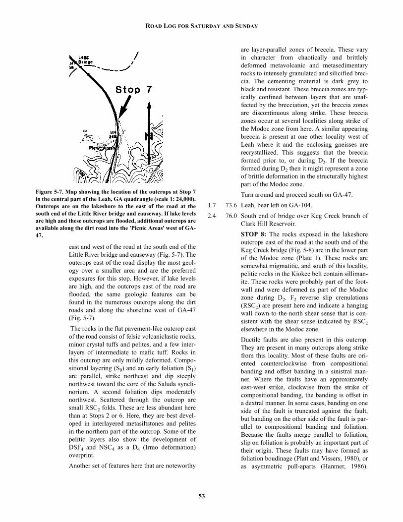
ROAD LOG FOR SATURDAY AND SUNDAY
east and west of the road at the south end of theLittle River bridge and causeway (Fig. 5-7). Theoutcrops east of the road display the most geol-ogy over a smaller area and are the preferredexposures for this stop. However, if lake levelsare high, and the outcrops east of the road areflooded, the same geologic features can befound in the numerous outcrops along the dirtroads and along the shoreline west of GA-47(Fig. 5-7). The rocks in the flat pavement-like outcrop eastof the road consist of felsic volcaniclastic rocks,minor crystal tuffs and pelites, and a few inter-layers of intermediate to mafic tuff. Rocks inthis outcrop are only mildly deformed. Compo-sitional layering (S0) and an early foliation (S1)are parallel, strike northeast and dip steeplynorthwest toward the core of the Saluda syncli-norium. A second foliation dips moderatelynorthwest. Scattered through the outcrop aresmall RSC2 folds. These are less abundant herethan at Stops 2 or 6. Here, they are best devel-oped in interlayered metasiltstones and pelitesin the northern part of the outcrop. Some of thepelitic layers also show the development ofDSF4 and NSC4 as a D4 (Irmo deformation)overprint.Another set of features here that are noteworthy
Figure 5-7. Map showing the location of the outcrops at Stop 7in the central part of the Leah, GA quadrangle (scale 1: 24,000).Outcrops are on the lakeshore to the east of the road at thesouth end of the Little River bridge and causeway. If lake levelsare high and these outcrops are flooded, additional outcrops areavailable along the dirt road into the 'Picnic Areas' west of GA-47.
53
are layer-parallel zones of breccia. These varyin character from chaotically and brittlelydeformed metavolcanic and metasedimentaryrocks to intensely granulated and silicified brec-cia. The cementing material is dark grey toblack and resistant. These breccia zones are typ-ically confined between layers that are unaf-fected by the brecciation, yet the breccia zonesare discontinuous along strike. These brecciazones occur at several localities along strike ofthe Modoc zone from here. A similar appearingbreccia is present at one other locality west ofLeah where it and the enclosing gneisses arerecrystallized. This suggests that the brecciaformed prior to, or during D2. If the brecciaformed during D2 then it might represent a zoneof brittle deformation in the structurally highestpart of the Modoc zone.Turn around and proceed south on GA-47.
1.7 73.6 Leah, bear left on GA-104.2.4 76.0 South end of bridge over Keg Creek branch of
Clark Hill Reservoir.STOP 8: The rocks exposed in the lakeshoreoutcrops east of the road at the south end of theKeg Creek bridge (Fig. 5-8) are in the lower partof the Modoc zone (Plate 1). These rocks aresomewhat migmatitic, and south of this locality,pelitic rocks in the Kiokee belt contain silliman-ite. These rocks were probably part of the foot-wall and were deformed as part of the Modoczone during D2. F2 reverse slip crenulations(RSC2) are present here and indicate a hangingwall down-to-the-north shear sense that is con-sistent with the shear sense indicated by RSC2elsewhere in the Modoc zone.Ductile faults are also present in this outcrop.They are present in many outcrops along strikefrom this locality. Most of these faults are ori-ented counterclockwise from compositionalbanding and offset banding in a sinistral man-ner. Where the faults have an approximatelyeast-west strike, clockwise from the strike ofcompositional banding, the banding is offset ina dextral manner. In some cases, banding on oneside of the fault is truncated against the fault,but banding on the other side of the fault is par-allel to compositional banding and foliation.Because the faults merge parallel to foliation,slip on foliation is probably an important part oftheir origin. These faults may have formed asfoliation boudinage (Platt and Vissers, 1980), oras asymmetric pull-aparts (Hanmer, 1986).

HARMON D. MAHER, Scott McIntyre, Paul E. Sacks and Donald T. Secor, Jr.
Another possible origin is as lateral ramps ofRSC2. RSC form where slip on foliation is animportant mechanism of strain (Dennis andSecor, 1987). Where the slip surface “rampsupward” from one foliation to another foliation,RSC folds form along the front of the ramp. Theductile faults may form as lateral ramps of theRSC, and be equivalent to the larger scale lat-eral ramps that are observed in fold and thrustbelts.Continue south on GA-104.
2.2 78.2 Pollards Corner, turn right on US-221/GA-304.0.7 78.9 Roadcut in ultramafic rocks of Burks Mountain
belt.2.5 81.4 Bridge over Greenbrier Creek. After crossing
bridge immediately turn left onto Kiokee Road.Outcrop of banded migmatitic biotite gneissalong Kiokee Road immediately after turn.
0.7 82.1 Outcrops of banded biotite gneiss and minoramphibolite.
0.3 82.4 Biotite gneiss and amphibolite intruded by gra-nitic sheets in roadcut on left.
0.3 82.7 Bridge over Kiokee Creek.
54
0.2 82.9 Marshall Historical Site sign.1.4 84.3 Turn right on Louisville Road.1.7 86.0 Turn left on dirt road leading to Heggies Rock.0.2 86.2 Drive to residence and park.
STOP 9: About one-third of a mile walk alongpath to Heggies Rock (Fig. 5-9a). Heggies Rockis an exceptional place, both biologically andgeologically, that is being returned to its pristinecondition by careful Nature Conservancy man-agement (Figs. 5-9b, 5-9c, 5-9d). PLEASELEAVE HAMMERS ON THE BUS. WHILEON THE OUTCROP, TREAD CAREFULLYAND AVOID DAMAGING THE PLANTSGROWING IN THE WEATHERING PITS OROTHER SOIL COVERED AREAS. Heggies Rock is regarded as the most importantof the Piedmont flat-rocks from a biologicalpoint of view, both because of the diversity ofrare plants that it contains and because it is lessdisturbed than most other flat rocks (Godfrey,1980).Geologically, Heggies Rock is an exceptionalexposure of the Appling Granite (Hurst and oth-
Figure 5-8. Map showing the location of outcrops along the lake shore at Stop 8 in the south-central part of the Leah, GA quadrangle(scale 1: 24,000). Additional outcrops are located to the east of the road at the north end of the bridge and along an unnamed creek1/2 mile east of the outcrops at Stop 8. 'Sill' notes the location of one of the northernmost outcrops of sillimanite bearing schist in thispart of the Kiokee belt and Modoc zone.

ROAD LOG FOR SATURDAY AND SUNDAY
Figure 5-9. a) Map showing the location of outcrops at Stop 9. b-d) Photos showing different parts of the flat rock exposures at Heg-gies Rock (Stop 9). e, next page) Photo showing xenolith of gneiss within the Appling granite at Stop 9. Note the K-feldspar mega-crysts.
55

HARMON D. MAHER, Scott McIntyre, Paul E. Sacks and Donald T. Secor, Jr.
ers, 1966). The essential minerals are quartz (c.20%) and feldspar (c. 75%) with accessorybiotite and amphibole(?) and a trace of epidote.Prominent euhedral K-feldspar megacrystsmake up c. 35% of the rocks (Fig. 5- 9e). Theseare locally aligned in a variably oriented flowfoliation. A few small gneissic and schistosexenoliths in various stages of assimilation canbe found (Fig. 5-9e). The Appling granite isinterpreted to be late Paleozoic in age becauseof its undeformed condition and lithologicalsimilarity to other late Paleozoic granitoids. Anaccurate igneous crystallization age has not yetbeen determined for the Appling. It has anexceptionally young biotite-whole-rock coolingage of c. 237 Ma (S.A. Kish, personal commu-nication, 1987). It is uncertain whether the gran-itoids in the interior of the Kiokee belt areweakly deformed to undeformed because theyare exceptionally young or because the Kiokeebelt interior has not experienced the intense latePaleozoic deformation that is manifested in theadjacent Modoc zone.Turn around and return to paved road.
0.1 86.3 Turn right on Lewistown Road and proceednortheast.
1.7 88.0 Turn right on Delph Road and proceed east.2.8 90.8 Turn left on GA-104 and proceed north toward
Pollards Corner.0.8 91.6 Bridge over Kiokee Creek.0.7 92.3 Migmatitic biotite gneiss and ultramafic rock in
roadcut on left.1.1 93.4 Silicified ultramafic rocks of the Burks Moun-
56
tain belt.0.5 93.9 Pollard's sawmill.0.5 94.4 Pollards Corner. Turn right on US-221. Proceed
east toward Clark Hill Dam.
END OF ROAD LOG FOR SATURDAY.
BUSES RETURN TO HICKORY KNOB STATE PARK.
SUNDAY ROAD LOG CONTINUES HERE.5.0 99.4 Turn right into road leading to the “Below Dam
Georgia Launching Ramp.”0.5 99.9 Turn left into parking area. Walk down steep
slope to rock outcrops in spillway to Clark HillDam.STOP 10: The spillway to Clark Hill Dam (Fig.5- 10a) contains an exceptionally good series ofoutcrops for viewing the lithologic and tectonicfeatures characteristic of the interior of the Kio-kee belt. The most common rock type is migma-titic biotite paragneiss containing layers orlenses of migmatitic biotite-sillimanite schist(Fig. 5-10b). The above units are intruded bystrongly deformed orthogneiss (Figs. 5-10b, 5-10c) containing mafic xenoliths. Finally, all ofthe above units are cut by sheets of weaklydeformed to undeformed fine- grained graygranite (Fig. 5-10b). The orthogneiss containsan intense foliation that has been stronglyrefolded, suggesting at least two different defor-mational episodes. The local presence of eye-

ROAD LOG FOR SATURDAY AND SUNDAY
Figure 5-10. a) Map showing the location of outcrops at Stop 10 (scale 1: 24,000). b-d) Photos of some features in the outcrops nearthe dam at Stop 10 (see text for explanation).
57

HARMON D. MAHER, Scott McIntyre, Paul E. Sacks and Donald T. Secor, Jr.
folds in the paragneiss (Fig. 5- 10d) also sug-gests a complex deformational history. Theage(s) of the earlier deformational episode(s) inthe spillway are unknown and cannot be corre-lated with certainty with D1 and/or D2 in theCarolina slate belt or Modoc zone. However, inthe spillway, there is a series of open to tight,northwest vergent flexural folds that are inter-preted to be F3 folds based on orientation, ver-gence, and style. On average, the migmatiticlayering is flat- lying, and the spillway is inter-preted to be near the crest of the F3 Kiokee anti-clinorium (Maher, this volume; Plate 1) The age and stratigraphic affinities of the mig-matitic sequence in the interior of the Kiokeebelt are uncertain (Sacks and Dennis, this vol-ume). Structural data from the Modoc zone sug-gest that the migmatitic sequence originated atleast tens of kilometers to the north-northeastrelative to nearby parts of the Carolina SlateBelt. The migmatitic sequence may be Grenvillebasement (as suggested by Farrar, 1985) but itdoes not resemble known Grenville basementlithologically, nor is it associated with a “NorthAmerican” cover sequence. The migmatiticsequence may be a basement terrane on whichthe volcanic arc(s) of the slate and Charlottebelts was constructed, or it may correlate withfelsic gneiss sequences in the Charlotte beltwhich it resembles lithologically. Finally, it ispossible that the migmatitic sequence is com-pletely exotic with respect to other rocks in thePiedmont, and is in fault contact with the AsbillPond formation along a line that is located in thesoutheastern part of the Modoc zone (Fig. 1-2).Turn around and return to US-221.
0.6 100.5Turn left onto US-221 and proceed west towardPollards Corner.
5.0 105.5Pollards Corner. Turn left on GA-104 and pro-ceed south toward Evans.
0.7 106.2Left turn immediately beyond lumber yard onOld Middleton Ferry Road leading to SecondMt. Carmel Church.
1.6 107.8Cross Old Petersburg Road. Continue straightahead on gravel road.
0.9 108.7Electric substation on left. Biotite gneiss out-crop on left also.
0.5 109.2Turn around and park. STOP 11: Burks Mountain ultramafics. Pro-ceed on foot about 500 m east along badly rut-ted and washed dirt road to base of slope (Fig.
58
5-11). Turn left and climb uphill to the northalong a path to a quarry in serpentinite. Out-crops extend east and west from the quarryalong the south side, crest and north side ofBurks Mountain. Hurst and others (1966) reportthat serpentinite was mined here in 1946-1947for production of magnesia. They also report thepresence of chromite and nickel anomalies asso-ciated with the ultramafic rocks. A talc- serpen-tine body approximately 2 km west of here isbeing investigated by the Georgia Geologic Sur-vey (Phil Perley, pers. comm.). Several prospectpits are scattered throughout the area of theultramafic bodies. This serpentinite body is one of several in theBurks Mountain belt of ultramafics (Sacks andothers, 1987). The rock here consists of massiveserpentinite. A mesh texture, which can beobserved in hand sample, and which is espe-cially prominent in thin section, suggests thatthe serpentine formed from the alteration ofperidotite consisting of olivine and pyroxene. Insome places, chromites in the serpentinite seemto define a foliation. In some places, alterationalong closely spaced, approximately planar sur-faces defines a parting in the outcrop. Metamor-phism of the serpentinite has resulted in thedevelopment of a talc overprint. This overprintvaries from the crystallization of isolated flakesof talc within the serpentinite to completereplacement to form soapstone or talc-amphib-ole schists. Some parts of this and other serpen-tinite bodies have been silicified. The result ofsilicification is a replacement of the serpentinewith quartz, but with the preservation of themesh texture.The serpentinite body here and the associatedultramafic and mafic bodies along strike areenclosed within migmatitic biotite amphibolegneiss (mbag on Plate 1 and POAL(C,-)gn2 onFig. 1-2). The northern and structurally lowercontact of the serpentinite body at Burks Moun-tain is marked by float of banded recrystallizedquartzite with magnetite and minor amphibole.Float of the quartzite is traceable along the northside of Burks Mountain eastward to the Savan-nah River. To the south, the serpentinite ismostly altered to talc-amphibole chlorite schistsand soapstone. The ultramafic and mafic rocksare enclosed in migmatitic gneisses that diptoward the southeast (Fig. 1-2 and Plate 1).The serpentine body here at Stop 11 is one ofseveral bodies of ultramafic and mafic rock in

ROAD LOG FOR SATURDAY AND SUNDAY
Figure 5-11. a) Map showing the location of outcrops at Stop 11 in the northern part of the Evans, GA-SC quadrangle (scale 1:24,000). Park at the location shown. Walk east along the badly rutted and eroded road approximately 500 m to the base of the slope,then follow path to the left (north) uphill to the serpentinite quarry and numerous outcrops on Burks Mountain.
59

HARMON D. MAHER, Scott McIntyre, Paul E. Sacks and Donald T. Secor, Jr.
this part of the Kiokee belt (Fig. 1-2). Thesebodies occur in a 20-30 km long concordant beltin the southeast limb of the Kiokee antiform.This belt has been called the Burks Mountainbelt of ultramafics (Sacks and others, 1987).Smaller bodies of similar ultramafic rocks arepresent in the northwestern limb of the Kiokeeantiform (Plate 1); these are probably a continu-ation of the Burks Mountain belt over the crestof the antiform. The geologic relationships ofthe ultramafic rocks and the enclosing gneissessuggests that they have similar metamorphicand deformation histories. Their origin and his-tory prior to the Alleghanian is as yet poorlyknown.Also of geologic interest at this stop is the effectof the serpentine on the plant life. Burks Moun-tain is the southernmost serpentine barren in thePiedmont (Godfrey, 1980). Magnesium richsoil, especially with chromium and nickel, thatdevelops on the serpentinite retards or elimi-nates most types of plants. The result is thesavannah characterized by dwarf blackjack oak,short and long leaf pines, and grassy open areas.Return to Old Petersburg Road.
1.3 110.5 Turn left on Old Petersburg Road and proceedsouth.
0.2 110.7 Outcrop of serpentinite partly altered to talc oneast side of road.
0.2 110.9 Migmatitic biotite amphibole gneiss, dippinggently southeast, cut by granitic dike on westside of road.
0.3 111.2 Migmatitic biotite gneiss with boudins ofbiotite-amphibole gneiss.
0.5 111.7 Intersection of Old Petersburg Road and GA-104. Turn left on GA-104 and proceed southeasttoward Evans.
0.1 111.8 Bridge over Kiokee Creek.7.6 119.4 Evans, GA. Junction of Belair Road Extension.
Continue south on GA-104.5.7 125.1At second traffic light before I-20 overpass (at
Gulf Station), turn left on Stevens Creek Road.0.3 125.4Intersection of Stevens Creek Road and Claus-
sen Road. Continue straight ahead on ClaussenRoad.
0.7 126.1After crossing railroad tracks, turn left ontoMurray Road.
0.3 126.4Turn right on entrance road toward MartinMarietta quarry.
60
1.1 127.5Parking lot at quarry office. Obtain permissionbefore entering.STOP 12: This large crush rock quarry providesan excellent exposure of the ductile Augustafault (Figs. 5-12a, 5-12b), which separatesBelair belt rocks to the SE from Kiokee beltrocks to the NW. Rocks in the structurally lowerNW quarry benches are Kiokee belt gneissesand schists without a mylonitic fabric, but witha more irregular gneissic layering. Rock types inthe structurally highest, SE quarry benches are amuscovite schist and a several meter thick,orthogneiss sheet. As suggested by Prowell(1980) the muscovite schist is likely a higher-grade, highly strained and recrystallized versionof the lowest stratigraphic unit within the Belairbelt. In between are mainly fine- grained,quartzo-feldspathic, blastomylonites. The com-position of the mylonites varies notably, and inturn the textures vary. Ductile shear was clearlyinhomogenous. Within the mylonites are numerous graniticveins that vary from discordant and unstrainedto semi-concordant, highly folded and internallystrained (Fig. 5-12c). Granitic veins, thus, wereinjected syn- and post-ductile shear and record aportion of the strain history. Analysis of the ori-entation and geometry of granitic veins suggestthey intruded during movement with a hangingwall-down component (Maher, 1987, in press).Occasional intrafolial folds within the myloniteare also consistent with such a kinematic setting(Fig. 5-12d).While the mylonites are well foliated, only amoderate to weakly developed lineation exists.This lineation is parallel to fold axes, plunging20-30o to the south. In thin sections cut parallelto the lineation numerous sense-of- shear indi-cators (Figs. 5-12e, 5-12f) consistently indicatehanging wall-down motion (Maher, in press).Occasionally, s and c surfaces are visible in out-crops of some of the coarser grained mylonites.Small brittle faults parallel to the mylonitic foli-ation show a hanging wall-down apparent offsetof discordant granitic veins. Striae on chloriticseams on the mylonite foliation are parallel tothe mylonitic lineation. Both these observationssuggest that Augusta fault movement continuedfrom a ductile into a brittle regime. The timingof movements is uncertain and needs to beascertained. A ductile to brittle transition is con-sistent with a D3 age, but the magmatic activity

ROAD LOG FOR SATURDAY AND SUNDAY
Figure 5-12. a) Map showing the location of Stop 12 in the Martinez quadrangle (scale 1: 24,000). b) View of SW end of Martin Mari-etta crush rock quarry. Note the moderate dip of the foliation to the left (SE). This is the mylonitic foliation of the Augusta fault zone.c) View to SW of intrafolial fold in mylonitic gneisses. Note the vergence. d, next page) View to SW of discordant folded granitic vein(arrows) with down-dip vergence. Dashed line represents trace of mylonitic foliation. e, next page) C surfaces in quartzo-feldspathicmylonite. View to SW in thin section parallel to the lineation; crossed Nichols. f, next page) Edge of quartz vein with well developedquartz subgrain fabric discordant to the quartz vein margin (arrows).
61

HARMON D. MAHER, Scott McIntyre, Paul E. Sacks and Donald T. Secor, Jr.
62

ROAD LOG FOR SATURDAY AND SUNDAY
suggests it is perhaps late D2 (assuming themagmatic activity is the same age it is on theNW limb of the Kiokee belt).The SW end of the quarry is cut by one of thebrittle faults of the Belair fault zone (Prowell,1980). This steep fault with well documentedCenozoic movement (Prowell, 1978; Prowelland O'Connor, 1978) offsets the Augusta faultzone in a sinistral fashion. Bramlett and others(1982) discuss the relationship of Augusta andBelair fault zones in more detail. We would liketo thank Martin Marietta for permission to bringthe field trip here. Permission can and must beobtained at the quarry office before entering thequarry.
END OF SUNDAY ROAD LOG.
BUSES RETURN TO HICKORY KNOB STATE PARK.
REFERENCES CITEDBramlett, K.W., Secor, D.T., Jr., and Prowell, D.C., 1982, The
Belair fault: A Cenozoic reactivation structure in the easternPiedmont: Geological Society of America Bulletin, v. 93, p.1109-1117.
Dennis, A.J. and Secor, D.T., Jr., 1987, A model for the develop-ment of crenulations in shear zones with applications from thesouthern Appalachian Piedmont: Journal of Structural Geology,in press.
Farrar, S.S., 1985, Tectonic evolution of the easternmost Piedmont,North Carolina: Geological Society of America Bulletin, v. 96,p. 362-380.
Godfrey, M.A., 1980, A Sierra Club naturalist's guide to the Pied-mont: San Francisco, California, Sierra Club books, 497 p.
Hanmer, S., 1986, Asymmetrical pull-aparts and foliation fish askinematic indicators: Journal of Structural Geology, v. 8, p.111- 122.
Hurst, V.J., Crawford, T.J., and Sandy, J., 1966, Mineral resourcesof the central Savannah River area: Atlanta, Georgia GeologicalSurvey, 467 p.
Maher, H.D., 1978, Stratigraphy and Structure of the Belair andKiokee belts near Augusta, Georgia, in Snoke, A.W., ed., Geo-logical investigations of the eastern Piedmont, southern Appa-lachians: Columbia, South Carolina Geological Survey,Carolina Geological Society Guidebook for 1978, p. 47-54.
Maher, H.D., Jr., 1979, Stratigraphy, metamorphism, and structureof the Kiokee and Belair belts near Augusta, Georgia: Colum-bia, University of South Carolina Master's Thesis, 94 p.
Maher, H.D., Jr., 1987, Kinematic history of mylonitic rocks fromthe Augusta fault zone, South Carolina and Georgia: AmericanJournal of Science, in press.
Maher, H.D., Jr., Palmer, A.R., Secor, D.T., Jr., and Snoke, A.W.,1981, New trilobite locality in the Piedmont of South Carolina,
63
and its regional implications: Geology, v. 9, p. 34-36.Platt, J.P., and Vissers, R.L.M., 1980, Extensional structures in
anisotropic rocks: Journal of Structural Geology, v. 2, p. 397-410.
Prowell, D.C., 1978, Distribution of crystalline rocks aroundAugusta, Georgia, and their relationship to the Belair Faultzone; in Snoke, A.W., ed., Geological Investigations of the east-ern Piedmont, southern Appalachians: Columbia, South Caro-lina Geological Survey, Carolina Geological SocietyGuidebook for 1978, p. 55-60.
Prowell, D.C., 1980, Ductile and brittle faulting in the southernKiokee belt and Belair belt of eastern Georgia and South Caro-lina: in Frey, R.W., ed., Excursions in southeastern geology:Leesburg, Virginia, American Geological Institute, p. 80-89.
Prowell, D.C., and O'Connor, B.J., 1978, Belair fault zone: Evi-dence of Tertiary fault displacement in eastern Georgia: Geol-ogy, v. 6, p. 681-684.
Sacks, P.E., Maher, H.D., Jr., and Secor, D.T., Jr., 1987, The BurksMountain belt of ultramafic rocks in the Kiokee belt, southernAppalachian Piedmont: Geological Society of America,Abstracts with Programs, v. 19, p. 127.