Embed Size (px)
Citation preview
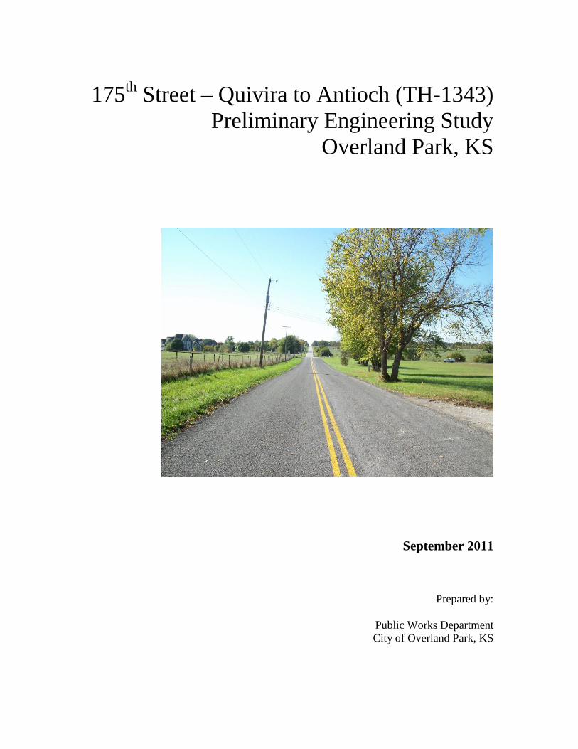
175th
Street – Quivira to Antioch (TH-1343)
Preliminary Engineering Study
Overland Park, KS
September 2011
Prepared by:
Public Works Department
City of Overland Park, KS
EXECUTIVE SUMMARY ............................................................................ 2
INTRODUCTION .......................................................................................... 3
BASIC INFORMATION AND PROCEDURES .......................................... 4
EXISTING CONDITIONS ............................................................................ 5
EXISTING UTILITIES ................................................................................. 7
TURN LANE STORAGE REQUIREMENTS ............................................. 8
PRELIMINARY DESIGN ............................................................................. 9
Design Criteria ........................................................................................................................... 9 Proposed Typical Sections ...................................................................................................... 10 Proposed Right-of-Way........................................................................................................... 10 Proposed Horizontal Alignments ........................................................................................... 10 Proposed Vertical Alignments ................................................................................................ 10 Proposed Drainage .................................................................................................................. 11 Historical Considerations ....................................................................................................... 11 Retaining Walls ........................................................................................................................ 11 Existing Lakes and Ponds ....................................................................................................... 11 Permitting................................................................................................................................. 12 Construction ............................................................................................................................. 12 Estimated Earthwork Volumes .............................................................................................. 12
OPINIONS OF PROBABLE COST ........................................................... 13
Total Project Cost Summary .................................................................................................. 13 Right-of-Way Costs ................................................................................................................. 14 Utility Relocation Costs ........................................................................................................... 19 Construction Costs .................................................................................................................. 20
APPENDIX .................................................................................................. 22
2
EXECUTIVE SUMMARY
This preliminary engineering study presents the results of the preliminary analysis to establish a
horizontal and vertical alignment for 175th Street from Quivira Road to Antioch Road. The
purpose of this study was to perform a preliminary design to minimize impacts to existing
development and to serve as a planning tool for future development.
More specifically, the major objectives of this study were as follows:
Establish design guidelines, typical roadway sections and right-of-way widths for 175th
Street, Quivira Road to Antioch Road.
Develop preliminary horizontal and vertical alignments for 175th Street, Quivira Road to
Antioch Road.
Size facilities for major drainage crossings (bridges and culverts).
Identify impacts to existing developments and infrastructure.
Provide opinion of probable total project cost including construction, utility relocation,
right-of-way, administration, legal and engineering costs based upon 2010 costs.
The comprehensive solution to meet the objectives set forth is summarized in subsequent pages in
this report.
175th Street is classified as a super-collector in the 2009 Master Plan and is designed to meet the
City’s super-collector standards consisting of a four-lane undivided roadway with two through
lanes in each direction. The roadway section also includes a single left turn lane at designated
locations, curb and gutter, enclosed drainage systems, sidewalks, bike/hike trails as designated by
the Greenway Linkages Master Plan and street lighting.
3
INTRODUCTION
The study presented herein was conducted by City staff and was required to include the
preparation of a preliminary engineering study and report together with preliminary scaled plans
and drawings.
The study establishes a recommended horizontal and vertical alignment for 175th Street from
Quivira Road to Antioch Road. Specifically, the study includes the following:
Recommended typical sections.
Required right-of-way widths.
Proposed horizontal and vertical roadway alignments.
Plan sheets showing existing right-of-way, ownership, utilities, and topographic features,
locations for retaining walls, construction limits and locations of major drainage
structures.
Drainage structure analyses including type, size, and location.
Roadway cross sections.
Opinion of probable project costs.
Each of these items is discussed in the following sections. In addition, plan and profile drawings
are part of the report appendix to illustrate the recommended roadway improvements.
This Preliminary Engineer Study has been prepared by City of Overland Park engineering staff at
the direction of the Director of Public Works and represents the best information available to the
City Engineer.
4
BASIC INFORMATION AND PROCEDURES
In the development of the preliminary design study, the following information and procedures
were utilized.
Topographic information along the 175th Street corridor was obtained from 2006 Johnson
County LIDAR data and incorporated into Plan and Profile sheets. Johnson County
provided the LIDAR data.
City ownership and plat maps were utilized to determine property owners and to plot
existing R/W and property lines.
Utility information was obtained through the Collaborative Utility Exchange (CUE) and
by contacting the utility companies. The utility information shown on the plan sheets
was taken from the CUE, and additional maps supplied to City staff, and does not
represent field-verified locations.
The existing surface was modeled from Bare Earth files in the 2006 LIDAR data set. The
created surface model has a tolerance of +/- 1 ft. at any given point.
The December 2009 Future Development Plan was obtained from the City of Overland
Park Planning and Development Services Department.
The City of Overland Park Planning and Development Services Department provided
turn bay locations and storage length requirements.
Design Criteria is in accordance with current ordinances for the City of Overland Park,
the Kansas Department of Transportation, and the American Association of State
Highway and Transportation Officials publication, A Policy on Geometric Design of
Highways and Streets.
Opinions of probable construction costs were based on 2010 dollar values. Recent bid
tabs and other historical cost information were utilized to establish 2010 unit prices.
“175th Street – 179
th Street to Quivira Road” prepared by BHC Rhodes, submitted
February 2008.
“Antioch Road from 167th Street to 179
th Street” prepared by Olsson Associates,
submitted August 2006.
5
EXISTING CONDITIONS
Roadways
175th Street is an east/west super-collector corridor serving Overland Park residents. It is a two
lane paved roadway with no shoulders and open ditches.
There are three intersecting thoroughfares – Quivira Road, Switzer Road, and Antioch Road.
Quivira Road and Switzer Road are currently two-lane undivided roadways with no shoulders and
open ditches. Antioch Road is currently a two-lane undivided roadway with no shoulders and
open ditches that ties into 175th Street from the south in an L intersection.
There are three intersecting side streets – Cody Street, Bond Avenue, and Bluejacket (Private).
All three are currently T intersections, and the study assumes that all three will remain the same.
There are 24 intersecting private drive entrances and one intersecting field entrance within the
study limits.
Existing Right-of-Way
The existing right-of-way ranges between 20 feet and 55 feet on either side of the section lines
through undeveloped tracts of land and between 40 feet and 60 feet on either side of the section
lines where subdivisions have been platted. The existing right-of-way is shown on the plan
drawings in the Appendix.
Traffic Counts
Traffic data from the City of Overland Park indicate 500 Average Daily Traffic (ADT) along
175th Street from the year 2010. A projected count of 9,000 ADT from 175
th Street is anticipated
for the year 2030. 175th Street is currently signed for 35 mph.
Land Use
The properties adjacent to the roadways in this study include small subdivisions as well as a mix
of small and large tracts of land. The current planned zoning for the majority of the study
corridor is low-density and very-low-density residential with parks, recreation, and open space on
the east end near Coffee Creek. Blue Valley Southwest High School is located on the southwest
corner of 175th Street and Quivira.
Existing Vertical Alignments
According to AASHTO design criteria, adequate stopping sight distance and/or intersection sight
distance is not currently available at several locations along 175th Street at the proposed design
speeds, particularly between Switzer Road and Antioch Road. Currently, the posted speed limit
along 175th Street is 35 mph. Because the proposed design speed for 175
th Street is 40 mph,
existing high spots in the profiles will need to be cut down and low spots will need to be filled in
to meet the new criteria.
6
Existing Drainage
There are currently open ditches adjacent to 175th Street. Eight (8) existing drainage structures
cross 175th Street. A 2’ x 3’ arched concrete culvert with a drop inlet structure crosses 175
th
Street approximately 435 ‘ east of Bond Avenue. A double 36” corrugated metal pipe crosses
175th Street approximately 415 west of Switzer Road. A 24” corrugated metal pipe crosses 175
th
Street approximately 0.3 miles east of Switzer Road. A 24” corrugated metal pipe crosses 175th
Street approximately 0.47 miles east of Switzer Road. A 18” HDPE pipe crosses 175th Street
approximately 0.47 miles west of Antioch Road. A 36” corrugated metal pipe crosses 175th
Street approximately 0.25 miles west of Antioch Road. A 21” corrugated metal pipe crosses
175th Street approximately 740 feet west of Antioch Road. A 21” corrugated metal pipe crosses
175th Street approximately 150 feet west of Antioch Road. None of these structures are sized to
pass the 100-year event. None of the structures are long enough to accommodate the proposed
typical section with adequate clear zone.
7
EXISTING UTILITIES
The major utilities in the study area are telephone, water, power, gas, sanitary sewers and fiber
optic. These utility lines and their respective sizes are shown on the plan drawings located in the
Appendix and are described in the following paragraphs. Note that all utility line locations are
approximate and are not guaranteed to be correct.
AT&T
AT&T has buried fiber optic facilities along the west side of Quivira Road north of 175th Street.
There are underground facilities along the south side of 175th Street from Quivira Road to Cody
Street, from Bond Avenue east 540’, and from Bluejacket Street east to Switzer Road. There are
underground facilities along the west side of Switzer Road north and south of 175th Street and
along the north side of 175th Street from Switzer Road to Antioch Road.
Water District No. 1 of Johnson County
WaterOne has a 36” transmission main along the north side of 175th Street from 179
th Street to
just east of Quivira Road and on the east side of Quivira Road from 175th extending to the north.
There is a 24” transmission main along the east side of Quivira Road south of 175th Street. There
is a 4” line along the south side of 175th Street beginning at Quivira Road, crossing to the north
side 0.5 miles west of Switzer Road, then crossing back to the south side at Switzer Road. A 2”
PVC line extends to a point 1,475’ west of Antioch Road. All of the lines appear to be in existing
waterline easement and would be a project cost.
Atmos Energy
Atmos Energy has a 4” plastic gas line along the west side of Switzer Road.
Kansas City Power & Light
KCP&L has overhead facilities along the north side of 175th Street beginning west of Quivira
Road. The line crosses to the south side of 175th Street approximately 1,000’ east of Quivira
Road and extends along the south side to a point approximately 1,350’ west of Antioch Road.
There are overhead facilities along the west side of Quivira Road north of 175th Street and along
the east side of Switzer Road south of 175th Street. There are overhead facilities along the west
side of Switzer Road north of 175th Street and along the east side of Switzer Road south of 175
th
Street. There are several underground crossings of 175th Street along the alignment.
Time Warner Cable
Time Warner Cable has overhead facilities attached to KCP&L’s poles along 175th Street from
Quivira Road east to a point 400’ east of Switzer Road; along Quivira Road south of 175th Street;
and along Switzer Road north and south of 175th Street. There are underground facilities on the
south side of 175th Street west of Quivira Road and at several crossings along 175
th Street.
Blue Valley School District
Blue Valley School District has a buried fiber optic line along the west side of Quivira Road
beginning at 179th Street. The line crosses to the east side approximately 300’ north of 175
th
Street.
8
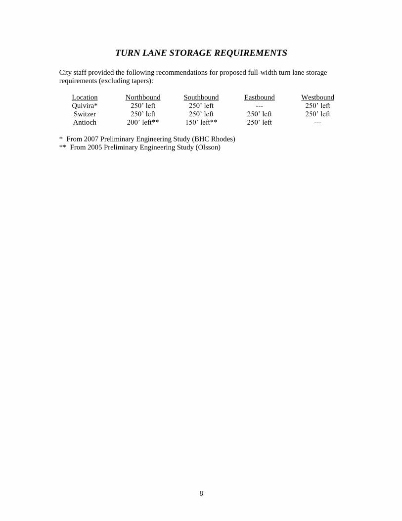
TURN LANE STORAGE REQUIREMENTS
City staff provided the following recommendations for proposed full-width turn lane storage
requirements (excluding tapers):
Location Northbound Southbound Eastbound Westbound
Quivira* 250’ left 250’ left --- 250’ left
Switzer 250’ left 250’ left 250’ left 250’ left
Antioch 200’ left** 150’ left** 250’ left ---
* From 2007 Preliminary Engineering Study (BHC Rhodes)
** From 2005 Preliminary Engineering Study (Olsson)
9
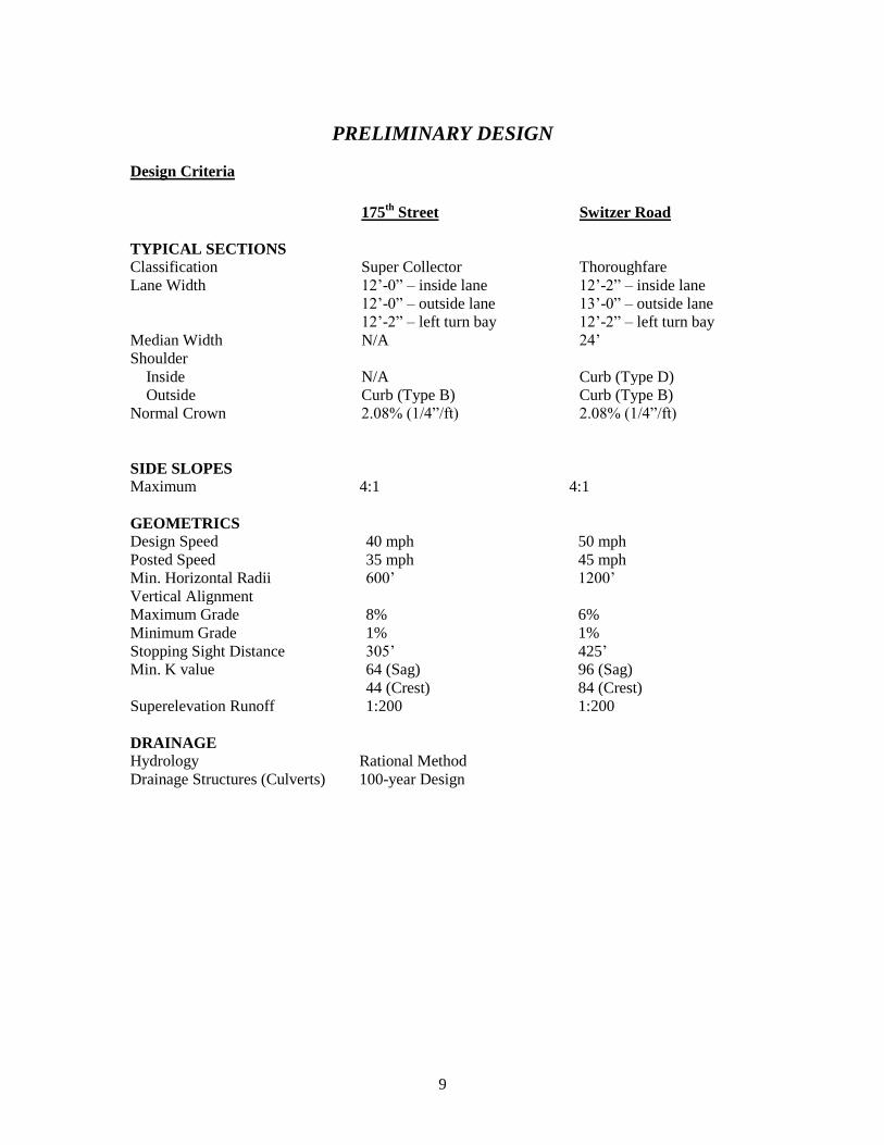
PRELIMINARY DESIGN
Design Criteria
175th
Street Switzer Road
TYPICAL SECTIONS
Classification Super Collector Thoroughfare
Lane Width 12’-0” – inside lane 12’-2” – inside lane
12’-0” – outside lane 13’-0” – outside lane
12’-2” – left turn bay 12’-2” – left turn bay
Median Width N/A 24’
Shoulder
Inside N/A Curb (Type D)
Outside Curb (Type B) Curb (Type B)
Normal Crown 2.08% (1/4”/ft) 2.08% (1/4”/ft)
SIDE SLOPES
Maximum 4:1 4:1
GEOMETRICS
Design Speed 40 mph 50 mph
Posted Speed 35 mph 45 mph
Min. Horizontal Radii 600’ 1200’
Vertical Alignment
Maximum Grade 8% 6%
Minimum Grade 1% 1%
Stopping Sight Distance 305’ 425’
Min. K value 64 (Sag) 96 (Sag)
44 (Crest) 84 (Crest)
Superelevation Runoff 1:200 1:200
DRAINAGE
Hydrology Rational Method
Drainage Structures (Culverts) 100-year Design
10
Proposed Typical Sections
The typical sections for the proposed roadways are shown in the Appendix. All thoroughfare and
super collector sections consist of a 10” thick asphaltic concrete pavement over a 6” aggregate
base course and a 8” fly ash treated subgrade.
Page 3 of the plans in the Appendix shows the four-lane super collector section recommended for
175th Street (Quivira Road to Antioch Road). The roadway width consists of a 12’ outside lane
and a 12’ inside lane. The roadway widens as it approaches the intersections of Quivira Road,
Switzer Road and Antioch Road to include a 12’-2” left turn lane and 4’ raised median. Five-foot
sidewalks are located 1’ inside the proposed right-of-way line. An 8’ hike/bike trail will be
utilized in locations designated by the Greenway Linkages Master Plan and will be located 1’
inside the proposed right-of-way line. The trail locations are shown in the plans.
Page 4 of the plans in the Appendix shows the standard four-lane thoroughfare section
recommended for Switzer Road. The roadway width consists of a 13’ outside lane and a 12’-2”
inside lane. This section includes a 24’ raised median which can be narrowed to 13’ or 4’ to
accommodate single of dual left turn lanes, respectively. Five-foot sidewalks are located 1’
inside the proposed right-of-way line. A 10’ hike/bike trail will be utilized in locations
designated by the Greenway Linkages Master Plan and will be located 1’ inside the proposed
right-of-way line. The trail locations are shown in the plans.
Proposed Right-of-Way
Right-of-way requirements are indicated on the plan drawings as well as the typical sections on
pages 3-4 of the Appendix. The super collector roadway section will require an 80’ right-of-way
corridor with an additional 20’ of right-of-way required to accommodate a left turn lanes at
Quivira Road, Switzer Road, and Antioch Road. The thoroughfare roadway section will require a
120’ right-of-way corridor.
Permanent drainage easements will be necessary for any stormwater treatment facilities and at the
ends of the crossroad drainage structures. Temporary construction easements will be necessary
along most properties adjacent to construction. There are also locations where utility easements
will be required for utility relocations. The exact locations of proposed utility easements should
be determined during the project design phase when more accurate utility information is
available.
Proposed Horizontal Alignments
A super collector section, centered on section line, is recommended for 175th Street as shown in
the Appendix. A thoroughfare section, centered on section line, is recommended for Switzer
Road as shown in the Appendix.
Proposed Vertical Alignments
The minimum design criteria for super collector and thoroughfare roadways are established by
Volume 1 of the Overland Park Design and Construction Standards and the 2004 edition of “A
Policy on Geometric Design of Highways and Streets” published by the American Association of
State Highway and Transportation Officials. In order to provide the required Stopping Sight
Distance (S.S.D.) for crest vertical curves on a super collector section, a minimum “K” value of
44 is required. The minimum “K” for sag curves on a super collector section based on headlight
sight distance is 64. In order to provide the required Stopping Sight Distance (S.S.D.) for crest
11
vertical curves on a thoroughfare section, a minimum “K” value of 84 is required. The minimum
“K” for sag curves on a super collector section based on headlight sight distance is 96.
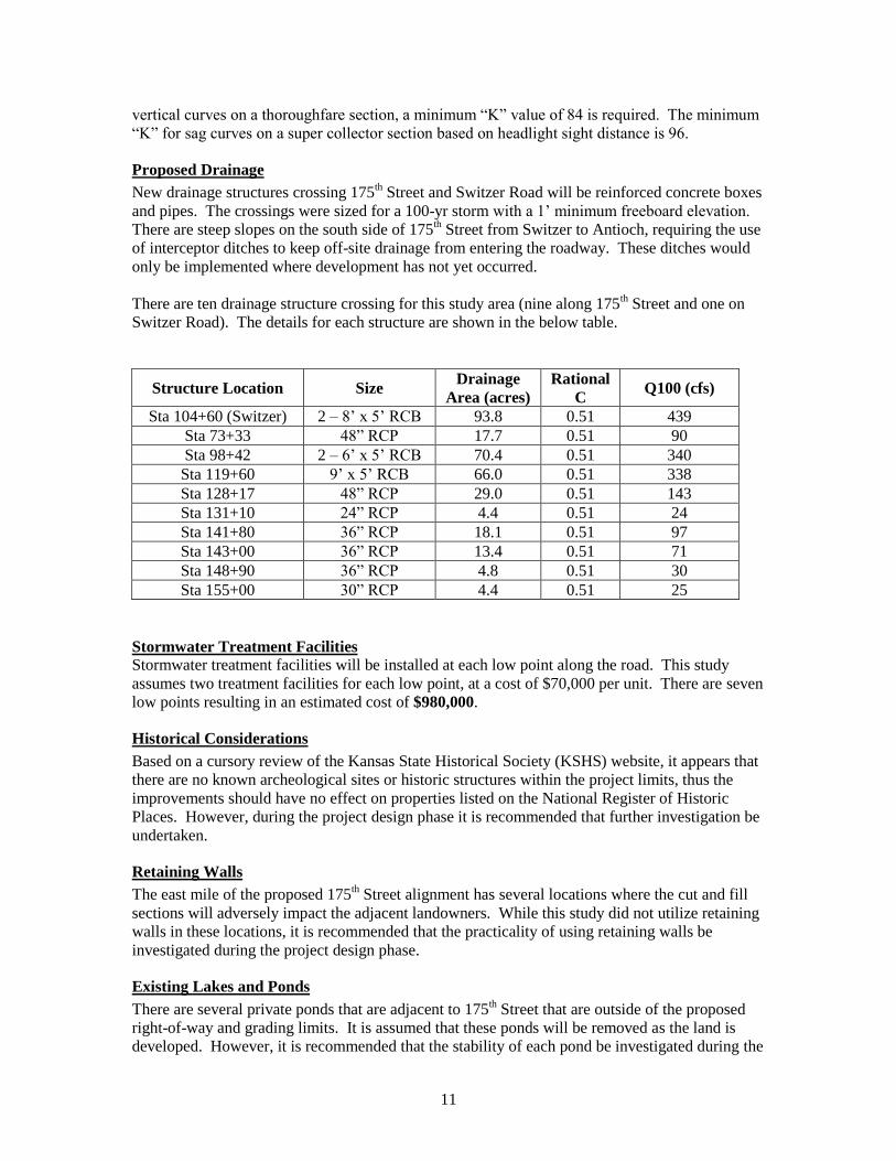
Proposed Drainage
New drainage structures crossing 175th Street and Switzer Road will be reinforced concrete boxes
and pipes. The crossings were sized for a 100-yr storm with a 1’ minimum freeboard elevation.
There are steep slopes on the south side of 175th Street from Switzer to Antioch, requiring the use
of interceptor ditches to keep off-site drainage from entering the roadway. These ditches would
only be implemented where development has not yet occurred.
There are ten drainage structure crossing for this study area (nine along 175th Street and one on
Switzer Road). The details for each structure are shown in the below table.
Structure Location Size Drainage
Area (acres)
Rational
C Q100 (cfs)
Sta 104+60 (Switzer) 2 – 8’ x 5’ RCB 93.8 0.51 439
Sta 73+33 48” RCP 17.7 0.51 90
Sta 98+42 2 – 6’ x 5’ RCB 70.4 0.51 340
Sta 119+60 9’ x 5’ RCB 66.0 0.51 338
Sta 128+17 48” RCP 29.0 0.51 143
Sta 131+10 24” RCP 4.4 0.51 24
Sta 141+80 36” RCP 18.1 0.51 97
Sta 143+00 36” RCP 13.4 0.51 71
Sta 148+90 36” RCP 4.8 0.51 30
Sta 155+00 30” RCP 4.4 0.51 25
Stormwater Treatment Facilities
Stormwater treatment facilities will be installed at each low point along the road. This study
assumes two treatment facilities for each low point, at a cost of $70,000 per unit. There are seven
low points resulting in an estimated cost of $980,000.
Historical Considerations
Based on a cursory review of the Kansas State Historical Society (KSHS) website, it appears that
there are no known archeological sites or historic structures within the project limits, thus the
improvements should have no effect on properties listed on the National Register of Historic
Places. However, during the project design phase it is recommended that further investigation be
undertaken.
Retaining Walls
The east mile of the proposed 175th Street alignment has several locations where the cut and fill
sections will adversely impact the adjacent landowners. While this study did not utilize retaining
walls in these locations, it is recommended that the practicality of using retaining walls be
investigated during the project design phase.
Existing Lakes and Ponds
There are several private ponds that are adjacent to 175th Street that are outside of the proposed
right-of-way and grading limits. It is assumed that these ponds will be removed as the land is
developed. However, it is recommended that the stability of each pond be investigated during the
12
project design phase to determine what impact, if any, they might have on the roadway during
construction if the land remains undeveloped.
Permitting
Permits will be required before beginning construction activities on this project. Due to the
continually changing nature of permitting requirements, it is recommended that the engineer
analyze permitting requirements during the project’s preliminary phase. The following permits
may be required and should be investigated:
USACE 404 Permit
Kansas DWR Permit
National Pollution Discharge Elimination System (NPDES) Permit
Federal Aviation Administration Form 7460-1
City Land Disturbance Permit
City Flood Plain Permit
Other
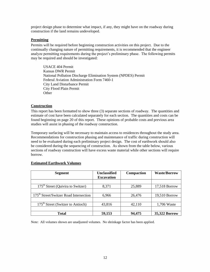
Construction
This report has been formatted to show three (3) separate sections of roadway. The quantities and
estimate of cost have been calculated separately for each section. The quantities and costs can be
found beginning on page 20 of this report. These opinions of probable costs and previous area
studies will assist in phasing of the roadway construction.
Temporary surfacing will be necessary to maintain access to residences throughout the study area.
Recommendations for construction phasing and maintenance of traffic during construction will
need to be evaluated during each preliminary project design. The cost of earthwork should also
be considered during the sequencing of construction. As shown from the table below, various
sections of roadway construction will have excess waste material while other sections will require
borrow.
Estimated Earthwork Volumes
Segment Unclassified
Excavation
Compaction Waste/Borrow
175th Street (Quivira to Switzer) 8,371 25,889 17,518 Borrow
175th Street/Switzer Road Intersection 6,966 26,476 19,510 Borrow
175th Street (Switzer to Antioch) 43,816 42,110 1,706 Waste
Total 59,153 94,475 35,322 Borrow
Note: All volumes shown are unadjusted volumes. No shrinkage factor has been applied.
13
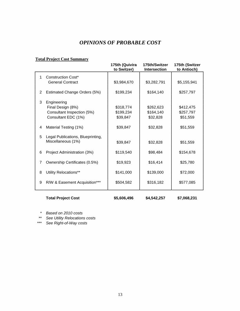
OPINIONS OF PROBABLE COST
Total Project Cost Summary
175th (Quivira to Switzer)
175th/Switzer Intersection
175th (Switzer to Antioch)
1 Construction Cost*
General Contract $3,984,670 $3,282,791 $5,155,941
2 Estimated Change Orders (5%) $199,234 $164,140 $257,797
3 Engineering
Final Design (8%) $318,774 $262,623 $412,475
Consultant Inspection (5%) $199,234 $164,140 $257,797
Consultant EDC (1%) $39,847 $32,828 $51,559
4 Material Testing (1%) $39,847 $32,828 $51,559
5 Legal Publications, Blueprinting,
Miscellaneous (1%) $39,847 $32,828 $51,559
6 Project Administration (3%) $119,540 $98,484 $154,678
7 Ownership Certificates (0.5%) $19,923 $16,414 $25,780
8 Utility Relocations** $141,000 $139,000 $72,000
9 R/W & Easement Acquisition*** $504,582 $316,182 $577,085
Total Project Cost $5,606,496 $4,542,257 $7,068,231
* Based on 2010 costs ** See Utility Relocations costs *** See Right-of-Way costs
14
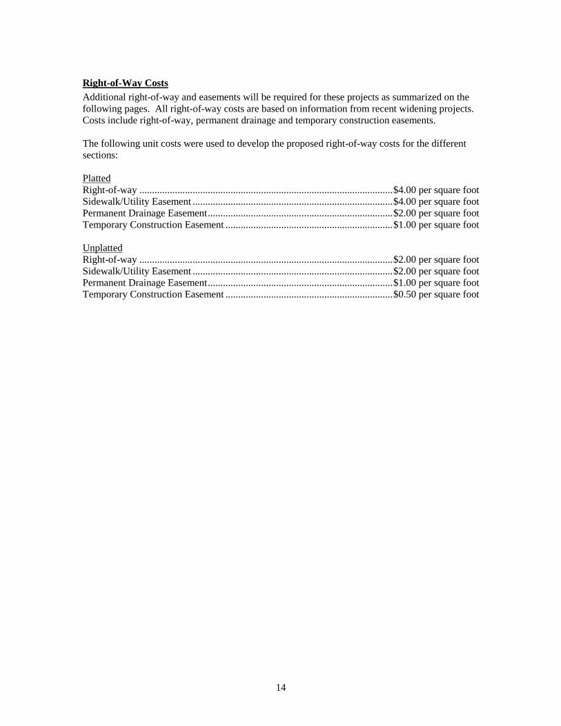
Right-of-Way Costs
Additional right-of-way and easements will be required for these projects as summarized on the
following pages. All right-of-way costs are based on information from recent widening projects.
Costs include right-of-way, permanent drainage and temporary construction easements.
The following unit costs were used to develop the proposed right-of-way costs for the different
sections:
Platted
Right-of-way .................................................................................................... $4.00 per square foot
Sidewalk/Utility Easement ............................................................................... $4.00 per square foot
Permanent Drainage Easement ......................................................................... $2.00 per square foot
Temporary Construction Easement .................................................................. $1.00 per square foot
Unplatted
Right-of-way .................................................................................................... $2.00 per square foot
Sidewalk/Utility Easement ............................................................................... $2.00 per square foot
Permanent Drainage Easement ......................................................................... $1.00 per square foot
Temporary Construction Easement .................................................................. $0.50 per square foot
15
175th Street (Quivira to Switzer)
Tract No. Easement Type
Approximate Area (sq. ft.)
Approximate Cost
Right-of-Way 0 $0
1 Temporary Construction 4,849 $4,849
Drainage 0 $0
Right-of-Way 0 $0
2 Temporary Construction 3,825 $3,825
Drainage 0 $0 Right-of-Way 0 $0
3 Temporary Construction 6,212 $6,212
Drainage 0 $0
Right-of-Way 0 $0
4 Temporary Construction 12,300 $12,300
Drainage 0 $0
Right-of-Way 0 $0
5 Temporary Construction 11,057 $11,057
Drainage 0 $0 Right-of-Way 0 $0
6 Temporary Construction 5,697 $5,697
Drainage 0 $0
Right-of-Way 0 $0
7 Temporary Construction 15,576 $15,576
Drainage 1,812 $3,625
Right-of-Way 0 $0
8 Temporary Construction 2,830 $2,830
Drainage 0 $0 Right-of-Way 6,000 $12,000
9 Temporary Construction 9,754 $4,877
Sidewalk/Utility 3,000 $6,000
Drainage 0 $0
Right-of-Way 5,504 $11,008
10 Temporary Construction 9,244 $4,622
Sidewalk/Utility 2,751 $5,501
Drainage 0 $0
Right-of-Way 12,663 $25,325
11 Temporary Construction 14,513 $7,257
Sidewalk/Utility 6,331 $12,663
Drainage 0 $0 Right-of-Way 2,424 $4,849
12 Temporary Construction 4,256 $2,128
Sidewalk/Utility 1,214 $2,429
Drainage 0 $0
16
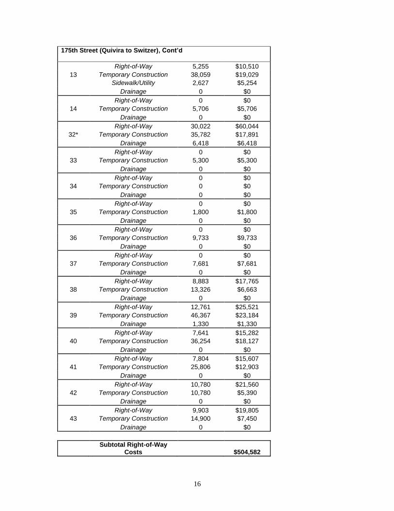
175th Street (Quivira to Switzer), Cont’d
Right-of-Way 5,255 $10,510
13 Temporary Construction 38,059 $19,029
Sidewalk/Utility 2,627 $5,254
Drainage 0 $0
Right-of-Way 0 $0
14 Temporary Construction 5,706 $5,706
Drainage 0 $0 Right-of-Way 30,022 $60,044
32* Temporary Construction 35,782 $17,891
Drainage 6,418 $6,418
Right-of-Way 0 $0
33 Temporary Construction 5,300 $5,300
Drainage 0 $0
Right-of-Way 0 $0
34 Temporary Construction 0 $0
Drainage 0 $0 Right-of-Way 0 $0
35 Temporary Construction 1,800 $1,800
Drainage 0 $0
Right-of-Way 0 $0
36 Temporary Construction 9,733 $9,733
Drainage 0 $0
Right-of-Way 0 $0
37 Temporary Construction 7,681 $7,681
Drainage 0 $0 Right-of-Way 8,883 $17,765
38 Temporary Construction 13,326 $6,663
Drainage 0 $0
Right-of-Way 12,761 $25,521
39 Temporary Construction 46,367 $23,184
Drainage 1,330 $1,330
Right-of-Way 7,641 $15,282
40 Temporary Construction 36,254 $18,127
Drainage 0 $0 Right-of-Way 7,804 $15,607
41 Temporary Construction 25,806 $12,903
Drainage 0 $0
Right-of-Way 10,780 $21,560
42 Temporary Construction 10,780 $5,390
Drainage 0 $0
Right-of-Way 9,903 $19,805
43 Temporary Construction 14,900 $7,450
Drainage 0 $0
Subtotal Right-of-Way
Costs $504,582
17
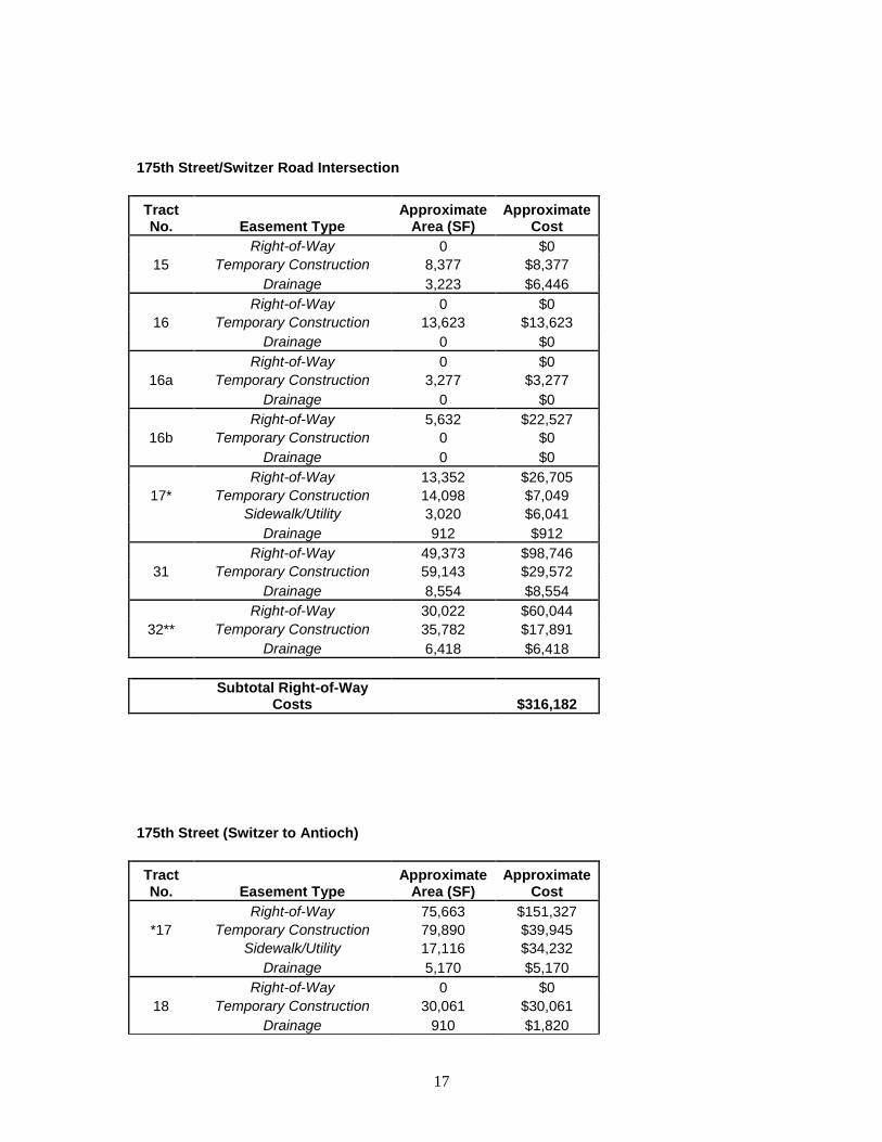
175th Street/Switzer Road Intersection
Tract No. Easement Type
Approximate Area (SF)
Approximate Cost
Right-of-Way 0 $0
15 Temporary Construction 8,377 $8,377
Drainage 3,223 $6,446
Right-of-Way 0 $0
16 Temporary Construction 13,623 $13,623
Drainage 0 $0
Right-of-Way 0 $0
16a Temporary Construction 3,277 $3,277
Drainage 0 $0 Right-of-Way 5,632 $22,527
16b Temporary Construction 0 $0
Drainage 0 $0
Right-of-Way 13,352 $26,705
17* Temporary Construction 14,098 $7,049
Sidewalk/Utility 3,020 $6,041
Drainage 912 $912 Right-of-Way 49,373 $98,746
31 Temporary Construction 59,143 $29,572
Drainage 8,554 $8,554
Right-of-Way 30,022 $60,044
32** Temporary Construction 35,782 $17,891
Drainage 6,418 $6,418
Subtotal Right-of-Way
Costs $316,182
175th Street (Switzer to Antioch)
Tract No. Easement Type
Approximate Area (SF)
Approximate Cost
Right-of-Way 75,663 $151,327
*17 Temporary Construction 79,890 $39,945
Sidewalk/Utility 17,116 $34,232
Drainage 5,170 $5,170 Right-of-Way 0 $0
18 Temporary Construction 30,061 $30,061
Drainage 910 $1,820
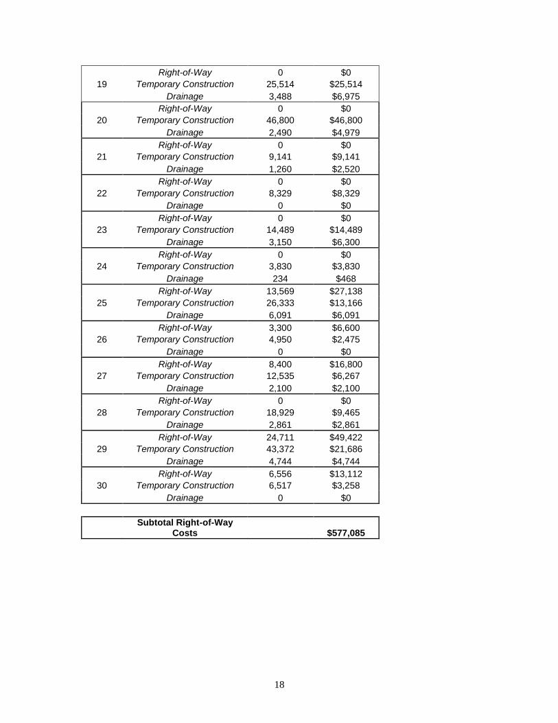
18
Right-of-Way 0 $0
19 Temporary Construction 25,514 $25,514
Drainage 3,488 $6,975
Right-of-Way 0 $0
20 Temporary Construction 46,800 $46,800
Drainage 2,490 $4,979 Right-of-Way 0 $0
21 Temporary Construction 9,141 $9,141
Drainage 1,260 $2,520 Right-of-Way 0 $0
22 Temporary Construction 8,329 $8,329
Drainage 0 $0
Right-of-Way 0 $0
23 Temporary Construction 14,489 $14,489
Drainage 3,150 $6,300 Right-of-Way 0 $0
24 Temporary Construction 3,830 $3,830
Drainage 234 $468 Right-of-Way 13,569 $27,138
25 Temporary Construction 26,333 $13,166
Drainage 6,091 $6,091
Right-of-Way 3,300 $6,600
26 Temporary Construction 4,950 $2,475
Drainage 0 $0 Right-of-Way 8,400 $16,800
27 Temporary Construction 12,535 $6,267
Drainage 2,100 $2,100 Right-of-Way 0 $0
28 Temporary Construction 18,929 $9,465
Drainage 2,861 $2,861
Right-of-Way 24,711 $49,422
29 Temporary Construction 43,372 $21,686
Drainage 4,744 $4,744 Right-of-Way 6,556 $13,112
30 Temporary Construction 6,517 $3,258
Drainage 0 $0
Subtotal Right-of-Way
Costs $577,085
19
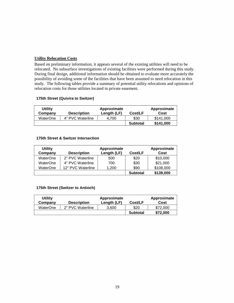
Utility Relocation Costs
Based on preliminary information, it appears several of the existing utilities will need to be
relocated. No subsurface investigations of existing facilities were performed during this study.
During final design, additional information should be obtained to evaluate more accurately the
possibility of avoiding some of the facilities that have been assumed to need relocation in this
study. The following tables provide a summary of potential utility relocations and opinions of
relocation costs for those utilities located in private easement.
175th Street (Quivira to Switzer)
Utility Company Description
Approximate Length (LF) Cost/LF
Approximate Cost
WaterOne 4" PVC Waterline 4,700 $30 $141,000
Subtotal $141,000
175th Street & Switzer Intersection
Utility Company Description
Approximate Length (LF) Cost/LF
Approximate Cost
WaterOne 2" PVC Waterline 500 $20 $10,000
WaterOne 4" PVC Waterline 700 $30 $21,000
WaterOne 12" PVC Waterline 1,200 $90 $108,000
Subtotal $139,000
175th Street (Switzer to Antioch)
Utility Company Description
Approximate Length (LF) Cost/LF
Approximate Cost
WaterOne 2" PVC Waterline 3,600 $20 $72,000
Subtotal $72,000
20
Construction Costs
Detailed preliminary opinions of cost are shown on the following pages. Separate quantities and
construction costs have been figured for each of the following sites:
175th Street (Quivira to Switzer)
175th Street & Switzer Road Intersection
175th Street (Switzer to Antioch)

21

22
APPENDIX