Embed Size (px)
Citation preview

16.2
122
On this spread you will find out about the erosion and deposition landforms along a stretch of the River Tees in County Durham, in north east England
River landforms on the River Tees
Where is the River Tees?
The River Tees is an important river in the north east
of England. Its source is high in the Pennine Hills near
Cross Fell (height 893 m). From there it flows roughly
east for around 128 km to reach the North Sea at
Middlesbrough (map A). Look back to page 95 to
locate the River Tees on the atlas map of the UK.
High Force waterfall and gorge
High Force on the River Tees is one of the UK’s most
impressive waterfalls. It is located close to Forest-in-
Teesdale in the river’s upper course. The river drops
20 m as a single sheet of water into the foaming and
turbulent plunge pool below. It then continues its
course through a spectacular gorge.
The waterfall was formed due to a resistant band of
igneous rock (cooled volcanic lava) called dolerite,
which cuts across the river valley. Unable to erode this
tougher band of rock, the river has formed a step in
the long profile of the river. This has developed over
hundreds of years to form High Force waterfall.
The underlying darker rock with horizontal layers
(called beds) is the Carboniferous limestone. The
overlying slightly lighter-coloured rock with vertical
joints is the dolerite. As the river plunges over the
waterfall, it undercuts the weaker limestone forming an
overhang. This eventually collapses and the waterfall
gradually retreats upstream to form a gorge. You
can see the steep side of the gorge to the left of the
waterfall in photo B.
Meanders, levees and floodplains near
Darlington
Map C is a 1:50 000 extract of the River Tees south of
Darlington (map A). Here the river is flowing from west
to east over relatively flat and low-lying land. All along
this stretch of the River Tees there are good examples
of meanders, levees and floodplains.
Locate grid square 3810 on map C. Look closely at the
river and notice the embankments, or levees, running
alongside the river meander. Notice also the extensive
white area of the map alongside the river. The lack of
brown contour lines in this area tells us that the land is
flat. This is the river’s floodplain.
MiddlesbroughDarlington
R
i ve
r Te es
N0 50
km
A The location of the River Tees in north-east England
B High Force on the River Tees
Stretch yourself
Use online mapping to find an aerial satellite
photograph of the mouth of the River Tees at Teesport
(Middlesbrough).
• Add labels to identify the wide river estuary (what is
its width?) and the mudflats.
• Try to identify the industries located alongside the
river.
• Why do you think this area has been developed for
industries?
11.5Ex
ampl
e

123
River landscapes
123
C OS 1:50 000 map
extract of the
River Tees near
Darlington
© Crown copyright
ACTIVITIES
1 Draw a sketch of High Force waterfall using
photo B. Add detailed labels to describe
its main characteristics and the fluvial
processes that are operating.
2 a What is the evidence from photo B that
the waterfall used to be more extensive
in the past?
b What is the evidence that the waterfall
is retreating to leave a gorge?
Practice question
To what extent does the River Tees illustrate
the features normally associated with a river’s
course from its source to its mouth? (6 marks)
8 cm
8 cm
09
08
07363534
3 Locate Sockburn on map C in 3408. Here a sweeping meander
passes through four grid squares.
a Draw an enlarged sketch map of the four grid squares but
doubling the scale, so that each square is 4 cm (diagram D).
b Now draw the course of the river and the 20 m contour
that runs alongside the river on either side.
c Draw any levees that have formed on either side of the river.
d Carefully label the following:
• the meander • the floodplain
• the direction of river flow • levees.
e How might the course of this meander change in the future?
Use a simple sketch to support your answer.
D Sketch map area
for activity 3
3433 3735 3836 39 40
09
11
08
07
10
12
13
14
1 kmN

124
11.6
On this spread you will find out about how physical and human factors can increase the risk of flooding
Factors increasing flood risk
What is flooding?
On 19 November 2009 a remote mountain weather
station at Seathwaite in the Lake District recorded an
astonishing 314.4 mm of rain in just 24 hours. This was
the wettest day ever recorded in the UK. It unleashed a
devastating flood that tore through valleys, washing away
bridges and inundating the small town of Cockermouth
(photo A).
Flooding is where land that is not normally underwater
becomes inundated. A river flood occurs when a river
channel can no longer hold the amount of water flowing
in it. Water overtops the banks and floods the adjacent
land – the floodplain.
What causes flooding?
River floods usually occur after a long period of rainfall,
often during the winter. The volume of water steadily
increases causing river levels to rise. Eventually the river
may overtop its banks to cause a flood.
Sudden floods can occur following torrential storms.
These are called flash floods. They are more often
associated with heavy rainstorms that occur in the summer.
We can identify both physical and human factors that
increase flood risk.
A Cockermouth floods, 2009
Physical factors
◆ Precipitation – torrential rainstorms
can lead to sudden flash floods as river
channels cannot contain the sheer
volume of water flowing into them. Steady
rainfall over several days can also lead to
flooding in lowland river basins.
◆ Geology (rock type) – impermeable rocks
(rocks that do not allow water to pass
through them) such as shales and clays
encourage water to flow overland and into
river channels. This speeds up water flow
and makes flooding more likely.
◆ Steep slopes – in mountain environments
steep slopes encourage a rapid transfer
of water towards river channels. This
increases the risk of flooding.
Human factors (land use)
◆ Urbanisation – building on a floodplain creates
impermeable surfaces such as tarmac roads,
concrete driveways and slate roofs. Water is
transferred quickly to drains and sewers and then into
urban river channels. This rapid movement of water
makes flooding more likely.
◆ Deforestation – much of the water that falls on
trees is evaporated or stored temporarily on leaves
and branches. Trees also use up water as they
grow. When trees are removed much more water
is suddenly available and transferred rapidly to river
channels, increasing the flood risk.
◆ Agriculture – in arable farming, soil is left unused and
exposed to the elements for periods of time. This can
lead to more surface runoff. This is increased if the
land is ploughed up and down steep slopes, as water
can flow quickly along the furrows.

125
River landscapes
125
Dis
char
ge (m
3 /sec
)
Time
Lag time(time between peak rainfall
and peak discharge)
Storm flow(overland flow
and throughflow)
Risinglimb
Rainfall
Falling limb
Peak discharge
Baseflow (groundwater flow)
What is a hydrograph?
The volume of water flowing along a river
is its discharge. It is measured in cumecs
– cubic metres per second. A hydrograph
is a graph that plots river discharge after a
storm (graph B). It shows how discharge
rises after a storm, reaches its peak and
then returns to the normal rate of flow.
One of the most important aspects of a
hydrograph is the time lag. This is the time
in hours between the highest rainfall and the
highest (peak) discharge. This shows how quickly water is transferred
into a river channel and is a key factor in the flood risk. The shorter the
time lag the greater the risk of flooding.
What affects the shape of a hydrograph?
The shape of a hydrograph is affected by rainfall and by drainage
basin characteristics (table C).
C Factors affecting the
shape of a hydrograph
ACTIVITIES
1 Describe the effects of the flooding in
Cockermouth (photo A). Consider the
social, economic and environmental
impacts.
2 What is the difference between a
normal river flood and a flash flood?
3 What features of the urban environment
increase the risk of flooding? Give
reasons for your answer.
4 What physical and human factors are
likely to produce a hydrograph (table C)
with a short time lag and a high peak?
Stretch yourself
Research online about the Cockermouth flood of 2009.
• What were the main physical and human causes of the flood?
• What were the impacts?
• What has been done since 2009 to reduce the likelihood of
future flooding?
• How successful were the post-2009 defences in coping with
the extreme rainfall in December 2015?
Practice question
‘River flooding is a natural phenomenon.’
To what extent do you consider this statement to be correct? (6 marks)
B A flood hydrograph
Drainage
basin and
precipitation
characteristics
‘Flashy’ hydrograph
with a short lag time
and high peak
Low, flat hydrograph
with a low peak
Basin size Small basins often lead to a rapid water transfer. Large basins result in a relatively slow water transfer.
Drainage density A high density speeds up water transfer. A low density leads to a slower transfer.
Rock type Impermeable rocks encourage rapid overland
flow.
Permeable rocks encourage a slow transfer by
groundwater flow.
Land use Urbanisation encourages rapid water transfer. Forests slow down water transfer, because of
interception.
Relief Steep slopes lead to rapid water transfer. Gentle slopes slow down water transfer.
Soil moisture Saturated soil results in rapid overland flow. Dry soil soaks up water and slows down its transfer.
Rainfall intensity Heavy rain may exceed the infiltration capacity of
vegetation, and lead to rapid overland flow.
Light rain will transfer slowly and most will soak into
the soil.

126
11.7
Clywedog reservoir, Llanidloes, Wales
The Clywedog reservoir (photo B) was constructed in
the 1960s to help prevent flooding of the River Severn.
Its concrete dam is over 70 m high and 230 m wide and
the reservoir stretches for nearly 10 km. It has been in
continuous use since 1967, filling up in the winter and
gradually releasing water in the summer to retain a
constant flow. Although some flooding has continued to
affect settlements further downstream, Clywedog has
undoubtedly prevented catastrophic floods.
On this spread you will find out about the costs and benefits of hard engineering to manage river flooding
Managing floods – hard engineering
What is hard engineering?
Hard engineering involves using man-made structures to
prevent or control natural processes from taking place.
This form of flood management is usually very expensive –
individual projects can cost several million pounds. But this
is the preferred option for protecting expensive property or
land, such as housing estates, railways and water treatment
works. The costs have to be weighed against the benefits.
◆ Costs – the financial cost of the scheme, and any
negative impacts on the environment and on
people’s lives
◆ Benefits – financial savings made by preventing
flooding, along with any environmental improvements
Diagram A shows the most common hard engineering
options to manage flooding.
Dams and reservoirs
Dams and reservoirs are widely used around the world to
regulate river flow and reduce the risk of flooding. Most
dam projects are multi-purpose, having several functions,
for example:
◆ flood prevention
◆ irrigation
◆ water supply
◆ hydro-electric power generation
◆ recreation.
Dams can be very effective in regulating water flow.
During periods of high rainfall, water can be stored in the
reservoir. It can then be released when rainfall is low. But
the construction of dams can be very controversial. They
cost huge amounts of money and the reservoir often floods
large areas of land. Many people may have to be moved
from their homes.
Afforestation to increase interception, reduce soil erosion, and use up some of the water
Construction of reservoir to regulate water flow
Land use zoning –new developments constructed away from flood risk areas
Controlled flooding to reduce serious floods downstream
By-pass channel
Creation of wetland areas for water storage
River bank conservation involving tree planting
Channel straightening to speed up water flow
Embankment to enlarge the channel and reduce the likelihood of flooding
Concrete-lined channel – semi-circular in shape to increase the speed of flow
Channel enlarged by dredging – taking sediment from the river bed and using it to build up the banks, so the river is lowered and the banks raised, increasing the channel's capacity
B The Clywedog dam and reservoir
A Flood prevention options
using hard engineering

127
River landscapes
127
The Jubilee River, Maidenhead
In the UK a flood relief channel, named the Jubilee
River, has been constructed on the River Thames near
Maidenhead in Berkshire (map C). The 11 km channel
was opened in 2002. It cost £110 million to construct
and with a length of nearly 12 km is the longest man-
made channel in the UK. As well as reducing the risk
of flooding for over 3000 properties, the Jubilee River
has had a positive impact on the environment by
creating new wetlands. It is also popular for recreational
activities such as walking and fishing.
Maidenhead
Eton
Windsor
Wraysbury
Jubilee RiverRiver Thames
N0 5
km
ACTIVITIES
1 Draw a diagram in the style of diagram A to
illustrate the different types of hard engineering
described on this spread.
2 Consider the costs (disadvantages) and benefits
(advantages) of dams and reservoirs such as at
Clywedog.
3 Construct a summary table to describe the costs
and benefits of the following hard engineering
options:
• channel straightening
• embankments
• flood relief channels.
Stretch yourself
Search online for more information about the Jubilee
River flood relief channel.
• Why was it built? (Had there been some serious
floods in the past?)
• What have been the environmental and social
benefits of the flood relief channel?
• Try to assess the costs and benefits of the Jubilee
River.
Practice question
To what extent are hard engineering schemes
sustainable? (6 marks)
C The Jubilee River
Channel straightening
River straightening involves cutting
through meanders to create a straight
channel. This speeds up the flow of water
along the river. Whilst river straightening
may protect a vulnerable location from
flooding, it may increase the flood risk
further downstream. The problem is not
really solved but shifted somewhere else!
In some places straightened sections of
river are lined with concrete. This speeds
up the flow and prevents the banks from
collapsing, which can cause the channel
to silt up. But the concrete channels
create a very unattractive and unnatural
river environment and can damage
wildlife habitats.
Embankments
An embankment is a raised
riverbank. Raising the level
of a riverbank allows the river
channel to hold more water
before flooding occurs.
Hard engineering structures
involving concrete walls or
blocks of stone are frequently
used in towns or cities to
prevent flooding of valuable
property. Sometimes mud
dredged from the river may
be used. This is cheaper and
more sustainable and looks
more natural.
Flood relief channels
A flood relief channel is a
man-made river channel
constructed to by-pass
an urban area.
During times of high
flow, sluice gates can be
opened to allow excess
water to flow away into
the flood relief channel
and reduce the threat of
flooding.

128
11.8
On this spread you will find out about the costs and benefits of managing river flooding using soft engineering
Managing floods – soft engineering
What is soft engineering?
Soft engineering involves working with natural river processes to
manage the flood risk. Unlike hard engineering it does not involve
building artificial structures or trying to stop natural processes. It aims
to reduce and slow the movement of water into a river channel to help
prevent flooding. In common with all forms of management there are
costs (disadvantages) and benefits (advantages).
Planting trees to establish a woodland or forest is called afforestation.
Trees obstruct the flow of water and slow down the transfer to river
channels. Water is soaked up by the trees or evaporated from leaves
and branches. Tree planting is relatively cheap and has environmental
benefits.
Wetlands and flood storage areas
Wetland environments on river floodplains are very efficient in storing
water (photo A). Wetlands are deliberately allowed to flood to form
flood storage areas. Water can be
stored to reduce the risk of flooding
further downstream.
Floodplain zoning
Floodplain zoning restricts different
land uses to certain locations on the
floodplain (diagram B). Areas close to
the river and at risk from flooding can
be kept clear of high-value land uses
such as housing and industry. Instead
these areas can be used for pasture,
parkland or playing fields. Floodplain
zoning can reduce overall losses
caused by flood damage. But it
can be difficult to implement on
floodplains that have already been
developed and can cause land
prices to fall.
River restoration
Where the course of a river has been
changed artificially, river restoration
can return it to its original course .
River restoration uses the natural
processes and features of a river,
such as meanders and wetlands
to slow down river flow and reduce
the likelihood of a major flood
downstream (photo C).
River
Pasture for
grazing
Playing
fields
Industry
Housing
Avoid areas
very near river
Roads and
car parks
A Flood storage area, near Rye,
East Sussex
B Floodplain zoning
C Restoration of the River Glaven, Norfolk
129
River landscapes
129
Preparing for floods
Rivers and river basins are monitored remotely using satellites and computer
technology. Instruments are used to measure rainfall and to check river levels.
Computer models can then be used to predict discharges and identify areas at
risk from flooding.
In England and Wales the Environment Agency issues flood warnings if flooding
is likely. Warnings are sent to the emergency services and the public using social
media, text and email. There are three levels of warning:
◆ Flood Watch – flooding of low-lying land and roads is expected. People should
be prepared and watch river levels.
◆ Flood Warning – there is a threat to homes and businesses. People should
move items of value to upper floors and to turn off electricity and water.
◆ Severe Flood Warning – extreme danger to life and property is expected.
People should stay in an upper level of their home or leave the property.
The Environment Agency makes maps identifying areas at risk from flooding.
People living in these areas are encouraged to plan for floods. This might include:
◆ planning what to do if there is a flood warning (e.g.
moving valuable items upstairs)
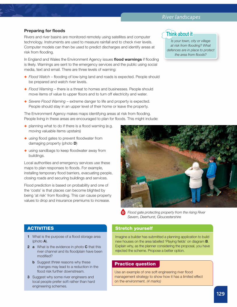
◆ using flood gates to prevent floodwater from
damaging property (photo D)
◆ using sandbags to keep floodwater away from
buildings.
Local authorities and emergency services use these
maps to plan responses to floods. For example,
installing temporary flood barriers, evacuating people,
closing roads and securing buildings and services.
Flood prediction is based on probability and one of
the ‘costs’ is that places can become blighted by
being ‘at risk’ from flooding. This can cause property
values to drop and insurance premiums to increase.
D Flood gate protecting property from the rising River
Severn, Deerhurst, Gloucestershire
ACTIVITIES
1 What is the purpose of a flood storage area
(photo A).
2 a What is the evidence in photo C that this
river channel and its floodplain have been
modified?
b Suggest three reasons why these
changes may lead to a reduction in the
flood risk further downstream.
3 Suggest why some river engineers and
local people prefer soft rather than hard
engineering schemes.
Stretch yourself
Imagine a builder has submitted a planning application to build
new houses on the area labelled ‘Playing fields’ on diagram B.
Explain why, as the planner considering the proposal, you have
rejected the scheme. Propose a better option.
Practice question
Use an example of one soft engineering river flood
management strategy to show how it has a limited effect
on the environment. (4 marks)
Is your town, city or village
at risk from flooding? What
defences are in place to protect
the area from floods?
Think about it