Embed Size (px)
Citation preview

1Onga river, Japan
J-river engineering for Vietnam
Workshop on erosion control in the Mekong DeltaSoc Trang, June 2015
Dr. MATSUKI Trung: JICA Expert
2
Project for Building Disaster Resilient Society in Vietnamhas an activity for
“small-scale and low-cost riverbank protection works”.
Contents1. Rivers make the rivers2-1. Foot protection mattress in Hue (2010)2-2. Single groyne in Quang Nam (2010)2-3. Foot protection groynes in Quang Binh (2014)2-4. Thalweg control in Ha Tinh (2015)3. Recommendations for Mekong Delta
Niyodo river, Japan

3Tsutami river, Japan
Rivers flow not only water but also sedimentthrough erosion, transport and deposition.
In a waterfall pocket, all process can be seen.
1. Rivers make the rivers
4
Water flow has tractive force which works on the riverbed.
Sediment resists against it with gravity and friction.
Riverbed morphology shows an equilibrium of the tractiveforce and the resistive forces.
Equilibrium on sediment

5
At a channel bend,
fast-moving surface water shift toward the outside due tothe centrifugal force, causing counter flow at the bottom.
These secondary flow and longitudinal flow combined tomake a spiraling flow, which scours riverbank leaving scourholes and a thalweg in front of the riverbank.
Spiraling flow
6
During a flood,water rises higher and runs faster.The spiraling flow gets larger to make the scour larger.The thalweg shifts downward and outward.
In the end of the flood,recession flow deposits sediment into the scour hole.The thalweg shifts back to upward and inward.
Thalweg shift

7Monobe river, Japan
Japanese traditional river engineering is a trial of using natural process of floods.
This is a basic concept of “rivers make the rivers”.
8
Japanese river engineering standards say that a dyke shall be protected from river flow by groynes and revetments. Groynes weaken the flow and revetments cover the dyke.
Kiso river, Japan Kagami river,Japan
Fuji river, Japan Onga river,Japan

9
2-1. Foot protection mattress- Ta Trach river at Kim Ngoc ward, T. T. Hue (2010)
Hue
Huong river
Ta Trach riverKim Ngoc village
10
Eroding bank after Flood 2009
100 m
Ta Trach river
Eroding bank
Jetty

11
Eroding bank after Flood 2009
To cover the eroding bank, a designed revetmentsystem was installed. The system has slopeprotection and foundation standardized inVietnam, and foot protection mattress made ofbamboo gabion under the water.
12
Eroding bank after Flood 2009
Tributary
Stream
Riverbak Protection Works
Existing Bank Protection Works(stone placing)
Flow direction
Community Road
Residential area of Kim Ngoc Ward (120 households)
Ferry service
Flow direction
(1)
(2)
(1) Slope Protection Works with Bamboo Stone Box (total length : 250m )
(2) Foot Protection Works by Bamboo Stone Gabion or Stone Riprap
13
Revetment has a set of structures namely;(1) slope protection, (2) foundation and (3) foot protection.
14
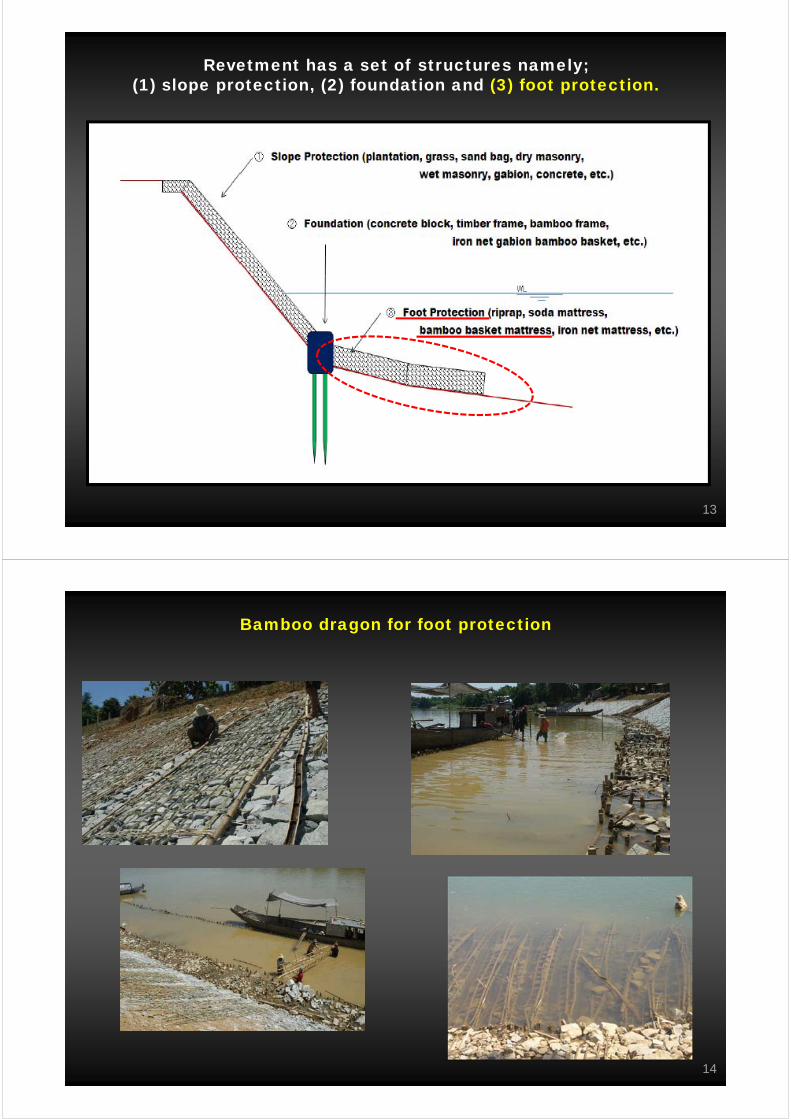
Bamboo dragon for foot protection

15
Bamboo dragon mattress 2 years after construction
16
Bamboo dragon 4 years after construction
The gabions foot protection prevents the rivergetting deeper during floods, so that the flowdoesn’t attack the bank that used to. After 4years, the river deposits 20cm sediment on thegabions and invites grass and crops.

17
2-2. Single groyne- Thu Bon river at Thanh Xuyen ward, Quang Nam (2010)
Hoi AnThu Bon river
Thanh Xuyen village
18
Eroding bank after Flood 2009
100 m
Eroding bank
Bamboo groyne (negative impact)
Natural groyne (rock outcrop)

19
Eroding bank after Flood 2009
To protect an eroding bank, a masonry groynestands on the crucial point and bamboo basketlay on the riverbank as a guide wall of deflectedflow.
……. ………. ………. …..………. …. ………
……….
………. …
....
Sand bar
Sand bar
Flow direction
Natural ? stone groin(existing)
Bamboo groin (existing)(sand bar length by spur dyke : 50 m in long Eroded slope
Flow direction
Community roadResidential area of Thanh Xuen Ward (250 households)
Rock(existing)
Rock(existing)
(1) Stone Groin (total length : 20m )
(2) Bamboo Stone Box(1m wide*1m long* 1m deep)
(3) Bamboo Groin (18m long* 5 sets with 50m internal)
(4) Bamboo Stone Gabion (1.5 m diameter* 1m high)
(5) Slope Protection (leveling and sodding, site works mainly by community people)
(1)
(2)
(3)
(4)
(5)
20
Eroding bank after Flood 2009

21
Masonry groyne completed
22
Bamboo fence/basket as foot protection
Bamboo Stone Gabion
Diameter: 1.5m
Height 1.0m
Prefablication of bamboo gabion net : It is simple net. Can be purchased at market.However, this gabion net can be prefablicated by community people.(strongly desired in view of livelihood improvement)
Lowest water level
Beacon sign
Stone size 10- 20 cm
Points to be reconsidered
Bamboo gabion in the first layer in the above Figure :
Gabion net : can be replaced by wire netStone to be filled in the net: can be replaced by gravel (not only sand) Material of bag ???

23
Masonry groyne 4 years after construction
24
Sand deposition after 4 years
The single groyne deflects strong flow and thebamboo wall guides the flow to downstream.The bank, now on a deposition area, is movingforward in this 4 years.

25
2-3. Foot protection groynes- Ran Nan river at Quang Son commune, Quang Binh (2014)
Ba Don
Gianh river
Quang Son communeRao Nan river
Song river
26
Eroding bank after Flood 2010
100 m
Rao Nan river
Eroding bankMarket
Natural rock
Bathymetric survey section
Protection section

27
Eroding bank after Flood 2010
Flood flowed on both banks ofa meandering channel leavingsome scour holes near amarket.This village sits on a low-lyingarea and river water flowedover roads and paddy field inthe flood 2010.
28
Proposed designed by a consultant

29
Revised design for non-negative impact and cost-cutting
Bathymetric survey was conducted before designing to select agrave section for cost-cutting. 6 small groynes were laid out onthe eroding bank.
30
Design of groyne
31
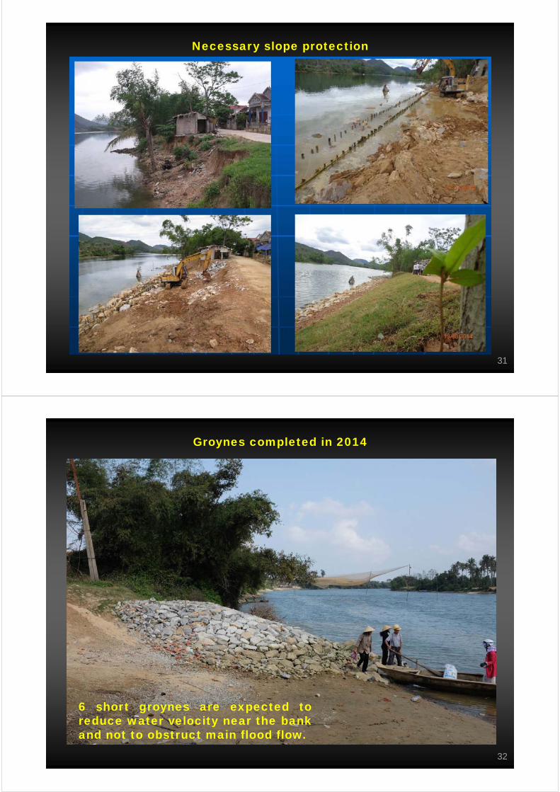
Necessary slope protection
32
Groynes completed in 2014
6 short groynes are expected toreduce water velocity near the bankand not to obstruct main flood flow.

33
2-4. Thalweg control - La river at Duc La commune, Ha Tinh (2015)
VinhLam river
Duc La commune
Ca river
Ngan Sau river
Ngan Pho riverLa river
34
Site designing on 2 February 2015

35
Groynes for thalweg control- Groynes let the river scour riverbed around its head part.
- Flood flow connects the scour holes to develop a thalweg.- The thalweg attracts strong spiral flow to go downstream.
- The river stops riverbank erosion and starts sand deposition.
Design process
Step 1: Field/boat survey to find out visible and touchable damages
Step 2: Bathymetric survey to draw a contour map
Step 3: Buried thalweg under the normal water level
Step 4: Active thalweg which might cause the damages
Step 5: Design thalweg witch doesn’t come close to the riverbank
Step 6: Groyne layout staring from the crucial point
Step 7: Groyne design to guide the thalweg to downstream
36
Step 1: Field/boat survey to find out visible and touchable damages
100 mBroken irrigation

37
Step 2: Bathymetric survey to draw a contour map
100 m
-6m-8m
-10m
Step 3: Buried thalweg under the normal water level
38
Step 4: Active thalweg which might cause the damages
100 m
-6m-8m
-10m
Step 5: Design thalweg witch doesn’t come close to the riverbank

39
Step 6: Groyne layout staring from the crucial point
100 m
Step 7: Groyne design to guide the thlweg to downstream- All groynes should touch at right angle to the design thalweg.
- Their crowns should not higher than the riverbank and the opposite-deposition.- The 1st and 2nd groynes should have a steep-angle (m=1.50) head on rock mattress.
- The 5th and 6th groynes should be a low structure declining in less than m=5.00.
40
Construction work on 15/22 April 2015

41
In delta areas,small size sediment is sensitive for tractive force anda thalweg is easily changeable on the wide channel.
Those conditions are severe for riverbank management butchallengeable to use the concept of “rivers make the rivers”.
Be aware that- riverbed and riverbank show us a power balance in flood,so that stronger flow promotes erosion and
milder flow puts sediment.
- flood-end period is a chance to get sediment.
- Erosion control is thalweg management on riverbed,rather than revetment on riverbank.
3. Recommendations for Mekong Delta
42
Revetments cover a dyke and decreases roughness.Smaller roughness make flow velocity faster and the spiralflow comes closer to the riverbank. Enlarged tractive forcescours deeper to destroy the revetments.
Rough-less disease (Be careful!)

43
Soda mattress is used in slow-flowing rivers as riverbankprotection or riverbed stabilization works. It has flexibilityand resiliency enough to prevent excessive local scour.Its fascine materials best fit fine silt in delta areas.
Soda mattress (Recommendable!)
44
For erosion control in Mekong Delta,there are 7 recommendations to be reconsider.
- Check geology, topography and river morphology.- Understand eroding-depositing process.- Use scientific theory and experimental know-hows.- Learn from the river and design at the site.- Order local material for cost-cutting and reparability.- Never make faster flow near riverbanks.- Gain sediment on the riverbanks from floods.
Finally I would like to continue this discussion at the site.Thank you very much.