Embed Size (px)
Citation preview

1/37
September 9, 2010September 9, 2010
Macao, ChinaMacao, China
Kamoto Kamoto
Report of WReport of WGHGH

2/37
• Progresses of Progresses of WGH AOP 2010 WGH AOP 2010
• New Proposed Projected and WGH AOP 2011
• Budget for WGH Budget for WGH 20112011

3/37
DateDate66 ~~ 8 Sept 8 Sept. 2010. 2010
ParticipantsParticipants
2233 from from 1010 Members Members (China, (China, DPRKorea, DPRKorea, Japan, Japan, Laos, Malaysia, Laos, Malaysia, Philippines, RPhilippines, ROOKorea, Korea, Thailand, USA, VietThailand, USA, Viet Nam) Nam) and ESCAP, TCSand ESCAP, TCS

4/37
ObjectivesObjectives1.1.To exchange information on To exchange information on
priorities and key areaspriorities and key areas2.2.To review progress of the To review progress of the
AAOPOP 2010 2010 3.3.To consolidate achievements To consolidate achievements
of priority projectsof priority projects4.4.To identify priority and To identify priority and
strategic needs of the TC strategic needs of the TC MembersMembers
5.5.To propose budget for WGH To propose budget for WGH in 2011in 2011

AOP1:On-the-job Training on Flood Forecasting between TC members
AOP2:
Urban Flood Risk Management in TC region
AOP3:
Assessment System of Socio-economic Impacts of Water-related Disasters for Infrastructure
AOP4:
Hazard Mapping for Sediment-related disasters
AOP5:Establishment of Flood Disaster Preparedness Indices
5/37
ProgressesProgresses of AOPs 2010 of AOPs 2010

6/37
AOP1AOP1 On-the-Job Training on On-the-Job Training on Flood Forecasting Flood Forecasting forfor TC TC membersmembers
KRA 1,KRA 1, 6 and 7 6 and 7
DDriver: river: MalaysiaMalaysia
Launched in 2002Launched in 2002
To be closed in To be closed in 2010 2010

7/99
OJT ObjectivesOJT Objectives• gain knowledge, appreciation and gain knowledge, appreciation and
experience on use of the Tank Model for experience on use of the Tank Model for flood forecastingflood forecasting ;;
• configure a flood forecasting model configure a flood forecasting model based on the Tank Model for a selected based on the Tank Model for a selected catchment in the participant’s countrycatchment in the participant’s country ;;
• calibrate the Tank Model and preparing calibrate the Tank Model and preparing the model for operational use in the the model for operational use in the participant’s respective organizationparticipant’s respective organization ;;
• develop expertise in writing simple develop expertise in writing simple macros (MSExcel) to automate model macros (MSExcel) to automate model computations – a skill which can be used computations – a skill which can be used to customize the model and further to customize the model and further enhance the model in the future.enhance the model in the future.

8/37
Main Benefit to Main Benefit to Trainees Trainees • understand the concept of understand the concept of
the Tank Model in the Tank Model in simulating flood runoff. simulating flood runoff.
• configure and calibrate a configure and calibrate a Tank Model for a river Tank Model for a river basin in the participant’s basin in the participant’s country.country.
• develop expertise in develop expertise in simple programming simple programming techniques which is useful techniques which is useful for future continual for future continual enhancement of the model enhancement of the model which is to be expectedwhich is to be expected

9/37
The 1st OJT: 21 Jan – 28 Feb. 2008
The 2nd OJT: 01– 31 Dec. 2008
The 3rd OJT: 21 July – 23 Aug. 2009
The 4th OJT: 12 July~ 06 Aug. 2010

10/37
Participants at Participants at the OJTsthe OJTs
TC Members DID
1st OJT2--Philippines, Vietnam
5
2nd OJT3--China, Laos, Vietnam
7
3rd OJT3--China, Laos, Thailand
16
4th OJT3--China, Laos, Vietnam
15
•11 trainees from TC 11 trainees from TC MembersMembers•43 trainees for Malaysia43 trainees for Malaysia

11/37
FundingFundingTCTF Malaysia
1st OJT US$2000 RM49,870 (~US$14,200)
2nd OJT US$3000 RM49,860 (~US$14,200)
3rd OJT US$3000 RM49,520 (~US$14,100)
4th OJT US$3000 RM49,520 (~US$14,100)
TotalUS$11,00
0US$42,600
12/37
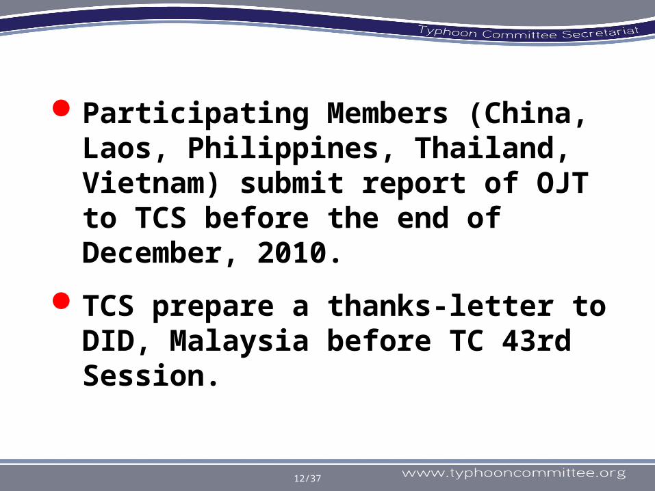
Participating Members (China, Laos, Philippines, Thailand, Vietnam) submit report of OJT to TCS before the end of December, 2010.
TCS prepare a thanks-letter to DID, Malaysia before TC 43rd Session.
13/37
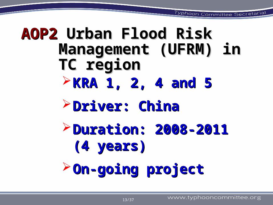
AOP2 AOP2 Urban Flood Risk Urban Flood Risk Management (UFRM) in Management (UFRM) in TC regionTC regionKRA 1,KRA 1, 2, 4 and 5 2, 4 and 5
DDriver: river: ChinaChina
Duration: 2008-2011 Duration: 2008-2011 (4 years)(4 years)
On-going project On-going project

14/37
Major FootprintsMajor Footprints2008 September IWS in Beijing
- Proposed by MWR China as a new WGH project
2009 January 41st Annual Session in Cheng Mai
- Confirmed as new project- Decision to survey TC WGH Focal Point
2009 September IWS in Cebu- Introduced results of survey by MWR
China
2009 December Telecom of WGHAWG meeting in Macao
- Discussed Mechanism and Major activities

15/37
Major Footprints (Cont.)Major Footprints (Cont.)2010 January 42nd Annual Session
in Singapore- Confirmed as cross-cutting project of TC - Decision to survey 3 Members (China,
Japan and R. of Korea) as good practice on UFRM (Side
meeting) - Decision to have a Task Force (TF) Meeting - Decision to consult with ESCAP to fund an
expert meeting of UFRM and the possibility of
contracting consultants to push forward the project.
2010 July Expert (TF) Meeting in Bangkok
- Finalize the Roadmap - establishment of the Task Force for UFRM
2010 September 5th TC IWS in Macao

China Japan R. o. Korea
WGM
WGH
WGDRR
16/37
• QQuestionnaire uestionnaire for collecting good for collecting good practicepractice
Progress in Progress in 20102010
TC Circular Letter to:
•Shanghai (China)
•Yokohama (Japan)
•Ansung (R. of Korea)

Good practices in urban flood management
a To establish the comprehensive urban flood management strategy
To highlight the land use planning.b
To enhance meteor-hydrological monitoring, forecasting and warning to provide timely, accurate and all-sided information support to the urban flood management.
c
To build up various dissemination ways of flood warning information to individual residents
e
To apply flood hazard/risk map widely as an important technique of urban flood preparedness.
d
To emphasize on the function of retarding basins and discharge ponds in the urban flood management
f
18/37
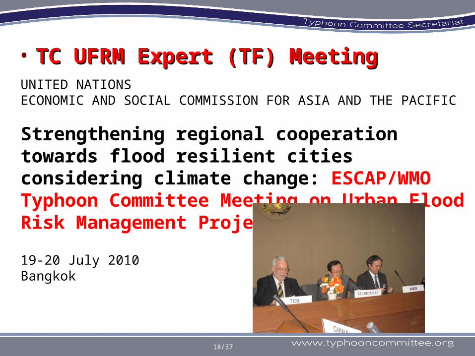
• TC UFRM Expert (TF) MeetingTC UFRM Expert (TF) MeetingUNITED NATIONSECONOMIC AND SOCIAL COMMISSION FOR ASIA AND THE PACIFIC
Strengthening regional cooperation towards flood resilient cities considering climate change: ESCAP/WMO Typhoon Committee Meeting on Urban Flood Risk Management Project
19-20 July 2010Bangkok

19/37
• 12 representatives from TC Members: China; Hong Kong, China; Japan; Macao, China; Philippines; Republic of Korea; Thailand and Vietnam;
• 3 resource persons from International Centre for Water Hazard and Risk Management (ICHARM), Japan Aerospace Exploration Agency (JAXA) and the ESCAP publication on Innovative Strategies for Flood Resilient Cities;
• 15 representatives from UNDP, UN/ISDR, UNOCHA, ADPC, ESCAP, WMO and TCS.
Participants

20/37
Topics for discussion
Project Overview and Information exchange
Mechanism of implementing UFRM
Selection of Pilot Cities for the UFRM
Activities of next steps
−Make clearly Objectives, Target areas and Outputs
−Roll of Task Force−Roll of National Focal Points in Pilot City−Support groups−Financial Resources

21/37
Background information on UFRM as the cross-cutting project among the 3 TC Working Groups was introduced by Chair of WGH;
The analysis of the questionnaire on good practices of UFRM project of 3 cities: Shanghai, Yokohama and Busan was reported by project leader;
Representatives from Philippines, Viet Nam, Thailand and Macao made the presentation on the impacts of flooding in Manila, Hanoi, Hat Yai and Macao.
Project Overview

22/37
Support GroupsESCAP, WMO
UFRM TF Chairs Vice-chairs TCS
National Focal Point of P.C.
TC AWG
Typhoon Committee
Structure of UFRM project (draft)
- Report to TC Session- Guidebook (Pilot Studies) (Recommendations) (Good Practice Inventory) (Useful materials)
- Guidance material- Advice- Materials- Analysis
-Contribute to other TC Members
Observer
CoachPlayer
- Consultation- Workshop
- Information- Results- Outputs
- Advice-Fund Rising- Project Formation
SupporterSupporter- Advice- Materials
- Advice- Materials
- Advice- Materials- Fund
Mechanism of Implementing UFRM

23/37
The Terms of Reference (TOR) of TF 1. The main objective of the Task Force is to
provide technical advisory to the cross cutting project of UFRM, including the following activities:a) Inventory of good practices b)Develop manual for implementation of the
projectc) Provision of technical advisory for pilot case
studies.
2. The Task Force will also create guidance material for UFRM based on the good practices and the pilot city studies, which can be used in other countries.
Objective of Task Force

24/37
Structure and Organization of TF
1)The Task Force consists of the three chairs and vice-chairs of the three Working Groups of TC, and TC Secretariat.
2)The chair of the WGH is the leader of the Task Force.
3)Support Groups which are approved by the Task Force can participate, fund and give advice to the pilot case studies.
4)Activities of Task Force members will be supported by in-kind contribution of Task Force members, however, contributions from donors are to be sought. In kind contribution from TC members and interested partners is encouraged.
5)The Task Force will be coordinated and supported by the Advisory Working Group (AWG) of TC.

25/37
Reporting of TFThe Task Force is required to provide timely progress report at TC session and seek advice when necessary.

26/37
Pilot Cities of UFRM Project
The criteria for selecting pilot cities:1)Cities which their national focal points are
willing to conduct studies and have agreed on using the study result in the guidance material;
2)Cities which were frequently affected by floods or storm surges induced by typhoons;
3)Cities which are socio-economically and environmentally important in their countries, as well as in the region or areas.
The pilot case studies will be implemented by national focal points, based on the manual for implementation of the project, with supports from various sources.

27/37
Four pilot Cities and the contact persons:
1)Metro Manila, Philippines, Dr. Susan R. Espinueva,
2)Hanoi, Viet Nam, Ms. Nguyen Lan Chau3)HatYai, Thailand, Mr. Thosakdi
Vanichkajom4)Macao, China, Mr. TANG Iu Man

28/37
• receiving the technical advices in view of reducing urban flood risk in the city in perspectives of meteorology, hydrology, disaster risk reduction as well as TC members such as exchanging the experiences on members’ good practices;
• potentially receiving financial support to hold workshop on urban flood risk reduction from Support Groups of UFRM;
• receiving the technical advices and the latest information from TC network on specific topics as requested by the cities; and
• receiving TC-AWG’s support to liaise with donors on urban flood risk reduction projects formulation.
The Pilot Cities will be benefited by:

29/37
TC is suggested to seek the further technical cooperation or funding support from UN agencies, international organizations, private companies or individuals as Support Groups of UFRM. 1)WMO, ADPC, ADRC, ICHARM and JAXA were
initially proposed as support groups of the project;
2)MLIT-Japan, MLTM- RoK, JICA, KOICA, ADB, WB-GFDRR also are suggested as the potential Support Groups, Although we need negotiation in advance.
Support Groups of UFRM Project

30/37
• excellent opportunity to show their visibility in the TC network;
• excellent opportunity to introduce their knowledge, technology and system to reduce flood risk in the pilot cities;
• excellent information on urban flood risk management in the pilot cities in perspectives of meteorology, hydrology, disaster risk reduction as well as their well-planned collaboration, e.g. other TC Members’ good practices; and
• opportunities to participate in the workshops on urban flood risk reduction which are organized and supported by the Support Groups of UFRM.
The Support Groups will be benefited from:

31/37
September 2010• Task force (TF) prepare and discuss draft guidance
material for pilot study;• Send invitation of pilot study to TC Members;• Send invitation letter to potential support group (SG).• Confirmation of Pilot Cities (PC); January 2011• Finalize of guidance material for pilot study and sent
it to PC;• Confirmation of SG.March 2011• PC prepare the implementation plan in consultation
with TF;• Implementation of pilot study (TF members visit PC). January 2012• TF reports to the Annual TC Session
Timeline of UFRM project
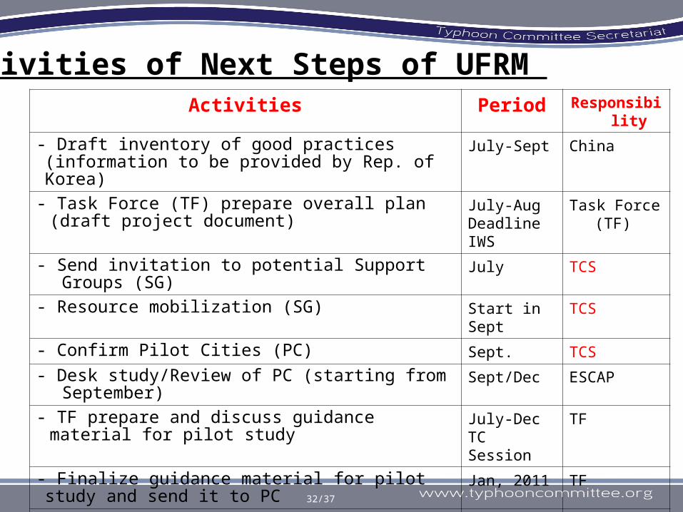
Activities Period Responsibility
- Draft inventory of good practices (information to be provided by Rep. of Korea)
July-Sept China
- Task Force (TF) prepare overall plan (draft project document)
July-AugDeadline IWS
Task Force (TF)
- Send invitation to potential Support Groups (SG) July TCS
- Resource mobilization (SG) Start in Sept TCS
- Confirm Pilot Cities (PC) Sept. TCS
- Desk study/Review of PC (starting from September) Sept/Dec ESCAP
- TF prepare and discuss guidance material for pilot study July-DecTC Session
TF
- Finalize guidance material for pilot study and send it to PC Jan, 2011 TF
- PC prepare the plan in consultation with TF March2011 TF
- TF provide additional information/advice 2011 TF
- Implement pilot study (TF member visit PC) March, 2011 PC
- TF report to Annual session Jan 2012 TF
32/37
Activities of Next Steps of UFRM

33/37
ESCAP is ready to provide USD 5,000 for consultancy on the desk review of the proposed cities. The money must be spent by the end of this year. ESCAP will seek funding to suppot TF member mission to PC in 2011Small meeting in June/July...

34/37
AOP3AOP3 Assessment System of Socio-economic Impacts of Water-related Disasters for Infrastructure
KRA 1, 2, 4 and 5KRA 1, 2, 4 and 5
Driver: Republic of KoreaDriver: Republic of Korea
Duration: 2008-2012 Duration: 2008-2012 (5years)(5years)
On-going project ---- On-going project ---- Korean side is arranging Korean side is arranging one-day WS. on Jan. 2011one-day WS. on Jan. 2011

35/37
• to establish the assessment to establish the assessment system of flood control system of flood control measuresmeasures
• To develop the highly To develop the highly applicable system for applicable system for international cooperation international cooperation among member countries.among member countries.
• to analyze socio-economic to analyze socio-economic impacts of flood control impacts of flood control measures, and to present measures, and to present standards for selecting an standards for selecting an optimal alternate.optimal alternate.
The purposeThe purpose

36/37
Assessment system construction Assessment system construction
Integrated and consistent processconstruction for the assessment and deduction of flood control measures Construction of program and
user manual available in domestic and abroad region
Objective assessment & deductionObjective assessment & deduction
Objective assessment and deduction of flood control measures
Socio-Economic impact analysisSocio-Economic impact analysis
Multilateral consideration of flood damage
Construction of independent shell program
Integrated Assessment systemIntegrated Assessment system
Suggesting reasonable standards of flood control measures
Integrated assessment system completion of flood control measures
Expected results

37/37
Investigation of domestic and foreign floodcontrol assessment system and establishment of plans
D/B, module, andsystem construction
Damage estimation and economic module construction
Flood control
assessment system
2008
2009
2010
2011
2012Module design of the system andmodule D/B design
Present status analysis &
establishment of plans
Present status analysis &
establishment of plans
Requirements analysis of users and analysis of structural measures
Requirements analysis of users and analysis of structural measures
System construction
System construction
Inside module
construction
Inside module
construction
Maintenance and
utilization
Maintenance and
utilization
Framing the plans for maintenance and utilization
Framing the plans for maintenance and utilization
Project schedule

38/37
AOP4AOP4 Hazard Mapping for Hazard Mapping for Sediment-related Sediment-related disasters disasters KRA 1,KRA 1, 2, 4 and 5 2, 4 and 5
DDriver: river: JapanJapan
Duration: 2009-2011Duration: 2009-2011
On-going project On-going project

39/37
• To develop & modify a method to designate area with high risk of sediment-related disasters
• To apply the method to some pilot areas of TC Member
ObjectiveObjectiveSediment-re
lated
disaste
r warning area
Special Sedim
ent-related
disaste
r hazard area
torrent where occurrenceof debris flow is predicted
Gradient of ground: morethan or equal to 2 degrees
Fig. Conceptual image of identification of area with high risk of sediment-related disaster caused by debris flow.
In case of JAPANIn case of JAPANGovernment controls developments in area where are designated as the “Special Sediment-related Disaster Hazard Area”. And government releases information on sediment-related disaster through Internet, TV and so on.

40/37
ProgressesProgresses• 1st year (2009)
– Japan distributed a draft of guideline and opened THD.
– Member countries selected model sites.
GuidelineGuideline
Help-DeskHelp-Desk
• China• Hongkong, China• The Philippines• Thailand • United States• Japan

41/37
• 2nd year (2010)– Field Training (priot to 5th TC IWS)– Member countries draw hazardous area in
the model sites.– Discuss technical problems at WS.
• 3rd year (2011)– Members countries make Hazard map.– Publish the guideline to reduce damage of
sediment-related disaster and to spread Japanese technique in Typhoon Committee Region.
Plan in next Plan in next yearyear

42/37
AOP5AOP5 Establishment of Flood Establishment of Flood Disaster Preparedness Disaster Preparedness Indices Indices KRA 1,KRA 1, 2, 4 and 5 2, 4 and 5
DDriver: river: JapanJapan
Duration: 2009~2011Duration: 2009~2011
On-going project On-going project

43/37
• When facing disasters, while role of central When facing disasters, while role of central government is important, in many countries, government is important, in many countries, assistance from the central government is often assistance from the central government is often insufficient and not timely. insufficient and not timely.
• Therefore enhancing disaster preparedness level Therefore enhancing disaster preparedness level of local Governments/communities is the key for of local Governments/communities is the key for flood management, by objectively flood management, by objectively checking/assessing the basic requirement items. checking/assessing the basic requirement items.
• It is necessary to develop and apply common and It is necessary to develop and apply common and convenient tools to assess and measures the level convenient tools to assess and measures the level of flood preparedness level of LGs. of flood preparedness level of LGs.
• There is, however, no well-structured set of widely There is, however, no well-structured set of widely recognized indicators that can be used for recognized indicators that can be used for periodical self-assessment by local governments. periodical self-assessment by local governments.
Target:Improvement of disaster preparedness level of local governments

44/37
Development and Development and application of application of commonly applicable commonly applicable indices possibly by indices possibly by questionnaire survey questionnaire survey

45/37
Requirements for FDPI • Designed for self and periodicalDesigned for self and periodical
self-assessment by local self-assessment by local governmentsgovernments
• Usable for bothUsable for both developing and developing and developed countriesdeveloped countries
• Should be assessed objectively by Should be assessed objectively by available data/information andavailable data/information and avoid arbitral evaluationavoid arbitral evaluation by by different evaluatorsdifferent evaluators
• Indicators need to beIndicators need to be appropriately appropriately weighedweighed for detecting weakness for detecting weakness factorsfactors
• Useful for not only LGs, but also for Useful for not only LGs, but also for national governments and donor national governments and donor communities for identifying communities for identifying support needssupport needs
For positive spiral of disaster management cycle
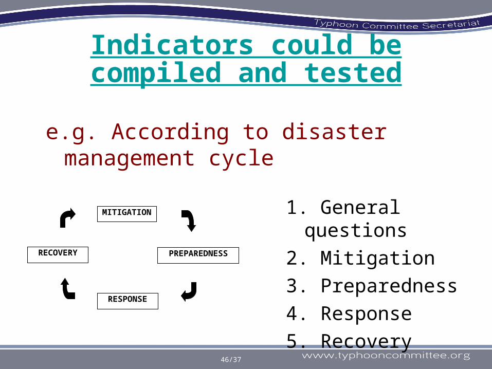
46/37
Indicators could be compiled and tested
e.g. According to disaster management cycle
MITIGATION
RESPONSE
PREPAREDNESSRECOVERY
1. General questions
2. Mitigation
3. Preparedness
4. Response
5. Recovery

1. Before the IWS at Macao; ICHARM, lead organization of this Flood Disaster Preparedness Indices (FDPI) project, had developed a set of disaster preparedness indices (a questionnaire survey including 78 points to be checked). At the same time, ICARM acquired the web site at http://www.fdpi.jp/fdpi/ where proposed questionnaire survey will be taken.
2. During Macao IWS; Japan will present in detail the configuration of questionnaire set together with introduction of the usage of newly-opened web-page from where questionnaire surveys will be taken. TC Members are then requested to cater this info. to disaster managers in many municipalities/communities in each territory.
3. By end-2010; Questionnaire survey will hopefully be participated by numerous number of municipalities/communities in TC members. Answers will be compiled and processed by ICHARM. Municipalities/communities will receive from ICHARM results of overall situation paper for flood preparedness level in TC region, as well as diagnosis report of flood preparedness level of each participating body.
Project Timeline for 2010

We have just prepared the site
http://www.fdpi.jp/fdpi/
-Terms and Condition
-78 questions
- Confirmation and sending

49/37
New Proposed Projected and WGH AOP 2011

50/37
1. Assessment of the 1. Assessment of the Variability of Water Variability of Water Resources Impacted by Resources Impacted by Climate ChangeClimate Change
KRA:KRA:
Proposed dProposed driver: river: PhilippinesPhilippines
Proposed in: 2009 at Proposed in: 2009 at Cebu IWSCebu IWS
New Proposed ProjectNew Proposed Project

51/37
To promote the actions of local government bodies/ communities to strengthen the level of preparedness and adaptation measures for problems on water resources impacted by Climate Change.
ObjectiveObjective

52/37
Philippine side was encouraged to prepare a proposal for 2010 Integrated Workshop.
To be discussed further

2. Satellite-based 2. Satellite-based information utilized on information utilized on reducing water-related reducing water-related disaster risksdisaster risks
KRA: 1, 4, 5, 6KRA: 1, 4, 5, 6
DDriver: river: ESCAPESCAP
Proposed Duration: 2010-Proposed Duration: 2010-20122012
New Proposed ProjectNew Proposed Project
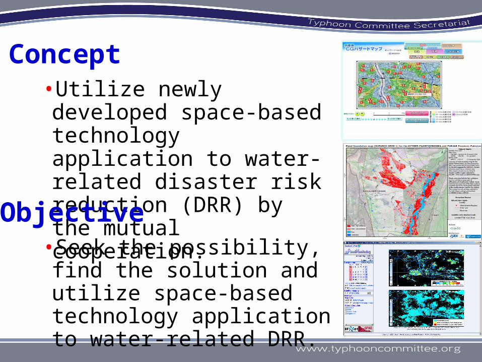
•Seek the possibility, find the solution and utilize space-based technology application to water-related DRR.
Concept•Utilize newly developed space-based technology application to water-related disaster risk reduction (DRR) by the mutual cooperation.Objective

Draft project plan
• First step(2010): Hold a workshop to
---- Share the information of newly developed space-based information technology status and the issues of water-related disaster risks;
---- Seek the utilization possibility of the space-based information technology to reduce water-related disaster risks

• Second step (2011; draft):
---- Find solutions of the issues
• Third step (2012; draft):
---- Make the load map and/or handbooks to apply the space-based information
Enlarged images of the swollen rivers at Shadan Lund (324 square km, left: August 6, 2010; right: October 2, 2009) provided by JAXA. http://www.eorc.jaxa.jp/ALOS/en/img_up/dis_opt_pakflood_100806.htm

Draft topics of the workshop on 7-9 December 2010 @ Bangkok• Driver/Cordination: ESCAP• Utilization potential of Satellite-based
information on reducing water-related risks (JAXA, ICHARM, ….)
• Issues of water-related disaster management to utilize space-based information (TC members)
• Discussion to find potential solutions to apply the space-based information.

Workshop Concept
IFAS Application
Satellite-based Information
Disaster Risk ManagementESCAP/WMO Typhoon Committee /Meteorology WG /Hydrology WG
/Disaster Prevention and p reparedness WG
GSMaP
Sentinel Asia /Disaster images and maps /GFAS web-site /MTSAT web-site
Ground-based Information

Draft Schedule of the Workshop(i) ICHAM will hold the topics of introduction
and usage of Integrated Flood Analysis System (IFAS) taking one and a half day.
(ii)JAXA will introduce the Sentinel Asia system which provides the disaster related information and Global Satellite Mapping of Precipitation (GSMaP).
Report of the WS will be made at TC Session in Jan. 2011.

Preparation Schedule of the Workshop• 25 Sept: ESCAP will send the
invitation letters to TC members with/without travel cost.
• 30 Sept: ICHARM will send the invitation letters to candidate agency with/without travel cost.
• 15 Oct: Close the participant response.
• 7-9 Dec: The workshop in Bangkok.

AOP1:
Urban Flood Risk Management in TC region
AOP2:
Assessment System of Flood Control Measures on Socio-economic Impacts
AOP3:
Hazard Mapping for Sediment-related disasters
AOP4:Establishment of Flood Disaster Preparedness Indices
AOP5:
Assessment of the Variability of Assessment of the Variability of Water Resources Impacted by Water Resources Impacted by Climate ChangeClimate Change
AOP6:
Satellite-based information Satellite-based information utilized on reducing water-related utilized on reducing water-related disaster risksdisaster risks
61/37
WGH AOP 2011WGH AOP 2011

62/99
Budget for WGH 2010

63/37
Item 2011
1
Support to attend Integrated Workshop (IWS) $10,000
2UFRM TF and PC WS for 3 cities $9000
Subtotal USD19,000

64/37
ThanksThanks
“The Shapers of New Asia”
“They include YOU and ME….”