Embed Size (px)
Citation preview
P A R T C
L o ca l Go ve rn m en t B i od i ve rsi ty Pl a n n in g Gu id e li n e s fo r th e Pe rth Me tro p o l i ta n R e gi o n
1 6 0
Lo
cal G
ove
rnm
ent p
olicy te
mp
late
s
13. Local Government policy templates
The templates and examples provided here have been developed by the Perth Biodiversity Project to give guidance to Local Government officers involved in the local biodiversity planning process. Templates and examples have been provided for the following:
sample Council agenda item sample Local Planning Policy for Biodiversity Conservation terms of reference for the Local Biodiversity Planning Steering Committee.
13.1. Sample agenda item to Council: initiating a local biodiversity planning process Obtaining Executive staff and Council support for preparation of a Strategy is an important first step of the local biodiversity planning process.
The following sample agenda item is provided to Local Governments who are seeking a Council resolution to prepare a Local Biodiversity Strategy. It is provided as an example only and should be read in conjunction with Part B of these Guidelines.
Local Government officers may model local items on this sample, but will need to amend it to suit each individual circumstance.
13.1.1. Sample agenda Item
LOCAL BIODIVERSITY STRATEGY FOR Shire/Town/City of (insert name)
In Brief
Council is requested to endorse the preparation of a local biodiversity Discussion Paper and Strategy using the ‘Local Government Biodiversity Planning Guidelines for the Perth Metropolitan Region’. A Discussion Paper is to be produced as a precursor to the Strategy to help in setting local objectives and consulting with the community and other stakeholders.
Background Biodiversity is the variety of all life forms – the different plants, animals and micro-organisms, the genes they contain, and the ecosystems of which they form a part.
There is a worldwide trend of decreasing biodiversity as development clears natural ecosystems and introduces new threats to native species and ecosystems.
The conservation of biodiversity is the responsibility of all levels of Government and all landholders. It is especially important given that the Perth Metropolitan Region forms part of one of 25 biodiversity hotspots recognised in the world (Myers et al. 2000).
At the national level, the Federal Government has passed legislation and provides funds for the conservation of biodiversity.
At the state level, legislation is in place to protect native flora and fauna, conservation estate lands are managed, and the Bush Forever initiative has identified specific sites of regional significance within the PMR that are to be protected.
At the regional level, community-led natural resource management (NRM) organisations (eg Swan Catchment Council) have produced regional strategies that have been accredited by the State and Federal Governments. These regional strategies will be used to allocate federal and state funds to projects. Local Governments can apply for funds under the regional strategy to prepare and implement parts of their local biodiversity strategies.
The Shire/Town/City of (insert name) has already recognised the importance of biodiversity conservation through various projects and policies (list relevant
I MPO RT ANT I NF ORM AT ION T O H E LP IN DE VE LOP ING A L OCA L B IOD IVE R SI TY S TUDY
L o ca l Go ve rn m en t B i od i ve rsi ty Pl a n n in g Gu id e li n e s fo r th e Pe rth Me tro p o l i ta n R e gi o n
1 6 1
Lo
cal
Go
vern
men
t p
oli
cy t
em
pla
tes
initiatives). It has also signed a Memorandum of Understanding with the Western Australian Local Government Association for the Protection of Native Vegetation.
However, it is now appropriate that local biodiversity conservation is addressed more strategically to address some of the following questions:
1) How much bushland and wetland must we/should we/can we protect as our shire or city is developed?
2) How much will it cost to manage our Local Natural Areas to conserve biodiversity?
3) How can we ensure that we will meet our legal requirements to protect Local Natural Areas on private and public lands?
4) How should we encourage the protection of bushland and wetlands on private lands?
5) How can we use our Town Planning Scheme and planning policies to ensure significant natural areas are protected? [May be appropriate to scope out the local needs that would be addressed by the preparation of a Strategy].
It is proposed that the Shire/Town/City of (insert name) prepare a Local Biodiversity Strategy to address these strategic questions. The preparation of the Strategy will be guided by the Local Biodiversity Planning Guidelines published by the Western Australian Local Government Association in 2004.
Strategies are non-statutory documents which plan for the protection and management of Locally Significant Natural Areas (LSNAs) across private and public lands. The strategies are designed to set long term targets (10-25 year horizons) and shorter term targets. These targets will enable the Shire/Town/City of (insert name) to demonstrate compliance with State and Federal Government policy and legislation and regional NRM targets.
Generally, a Local Biodiversity Strategy has four major components:
Local Planning Policy for Biodiversity Conservation Incentives Strategy for Private Land Conservation planning for the management of local reserves and other Local Government lands
to conserve biodiversity formalisation of the protection status of LSNAs.
These components are built and implemented over the four-phase process described in the Guidelines:
Phase One: Project scoping (this item is a part of Phase One)
Phase Two: Discussion paper preparation (6 to 12 months estimated)
Phase Three: Strategy preparation and establishment of its components such as Local Planning Policy and Incentives Strategy) (1 to 3 years estimated)
Phase Four: Strategy implementation (ongoing)
The Strategy will form part of Council’s Local Planning Strategy and some parts will need to be incorporated into the Town Planning scheme to have effect.
Local biodiversity planning Phases Phase 1. Scoping
This involves initiating the local biodiversity planning process by:
scoping out the local biodiversity planning and conservation process
obtaining Council commitment to the process commitment of resources to complete Phase 2
forming a steering committee/working group.
P A R T C
L o ca l Go ve rn m en t B i od i ve rsi ty Pl a n n in g Gu id e li n e s fo r th e Pe rth Me tro p o l i ta n R e gi o n
1 6 2
Lo
cal G
ove
rnm
ent p
olicy te
mp
late
s
Phase 2: Discussion Paper
The Guidelines encourage a Discussion Paper (Phase 2) to be prepared before the full Strategy is drafted. This is so that local biodiversity conservation objectives can be set which take into account the local community aspirations, and the prevailing constraints and opportunities in the Local Government area.
The key outputs from the Discussion Paper are:
identification, quantification and mapping of the biodiversity resource
development of a vision and objectives for the Strategy establishment of Natural Area Condition targets to formalise the ecological criteria
to be used to identify which Local Natural Areas are locally significant (LSNAs) identification of the four key components of a Strategy that will help meet the local
biodiversity targets.
Following community consultation on the Discussion paper, Council will be able to endorse specific local biodiversity targets to allow the preparation of the Strategy.
Phase 3: Preparation of Local Biodiversity Strategy
An Action Plan is developed at the beginning of this Phase to guide the Strategy’s preparation and implementation (Phase 4). It will contain detailed information on how the Strategy’s targets and objectives will be met.
The following are key components of Phase 3:
preparing a Local Planning Policy for Biodiversity Conservation preparing a Incentives Strategy for Private Land Conservation planning for the management of biodiversity on Local Government land
formalising the protection status of LSNAs endorsing and finalising the Strategy.
The Local Planning Policy, Incentives Strategy for Private Land Conservation and the planning for the management of Local Government lands provide the process for strategic assessment of all natural areas (on private and public lands) to determine those that are locally significant. The assessment of natural areas to determine those that are locally significant requires completion of a thorough desktop and field assessment utilising information and natural area assessment templates provided within the Local Biodiversity Planning Guidelines.
Phase 4. Implementation of Local Biodiversity Strategy
Upon completion of the Strategy there will be a number of new activities and existing policy and processes that will need to be implemented, these include:
staff training and technical support
review/amendment of Town Planning Scheme application of Local Planning Policy
application of private land biodiversity Incentives Strategy management of Local Government land for biodiversity outcomes monitoring and review of the Strategy.
Parts of the Shire/Town/City of (insert name) covered by the Local Biodiversity Strategy The Strategy focuses on Local Natural Areas. Local Natural Areas are natural areas that exist outside of Bush Forever Sites (Swan Coastal Plain), the Department of Conservation and Land Management (CALM) Managed Estate and Regional Parks. Local Natural Areas occur on public and private lands. The Strategy also includes Bush Forever sites managed by the Local Government.
Local natural areas do not have any existing process to assess biodiversity values for their protection and management, other than existing general environmental and planning processes.
I MPO RT ANT I NF ORM AT ION T O H E LP IN DE VE LOP ING A L OCA L B IOD IVE R SI TY S TUDY
L o ca l Go ve rn m en t B i od i ve rsi ty Pl a n n in g Gu id e li n e s fo r th e Pe rth Me tro p o l i ta n R e gi o n
1 6 3
Lo
cal
Go
vern
men
t p
oli
cy t
em
pla
tes
A Strategy will also address how Local Natural Areas relate to and support the biodiversity values of the CALM estate, Bush Forever Sites and Regional Parks. Our local Strategy will also need to consider the relationships of Local Natural Areas to other natural areas at the regional, national and international level.
The term ‘natural area’ is used in biodiversity planning to describe an area that contains native species or communities in a relatively natural state and hence contains biodiversity. Natural areas can be areas of native vegetation, vegetated or open water bodies (lakes, swamps), or waterways (rivers, streams, creeks), estuaries, springs, rock outcrops, bare ground (generally sand or mud), caves, coastal dunes or cliffs (adapted from Environmental Protection Authority 2003a). Note that natural areas exclude parkland cleared areas, isolated trees in cleared settings, ovals and turfed areas.
Broad description of natural areas in the Shire/Town/City of (insert name) Whilst the amount of biodiversity in the Shire/Town/City of (insert name) cannot be easily measured, statistics on natural areas, such as the amount of native vegetation and wetlands and the condition of these provide an indicative measure of the state of our biodiversity at a regional scale.
Natural areas in the Shire/Town/City of (insert name)
(Insert statistics for Local Government as provided by the Perth Biodiversity Project):
For example:
area of mapped native vegetation by vegetation complex area of wetlands by wetland type
area of wetlands by wetland management category number and occurrences of Declared Rare Flora (DRF), and Threatened Ecological
Communities (TECs).
The above statistics have limited value in decision-making and cannot be used to make decisions at the local or site scales. This will be achieved through the Local Biodiversity Strategy.
Statutory environment The preparation of a Local Biodiversity Strategy will enable the Shire/Town/City of (insert name) to proactively address the requirements of the following legislation as they relate to biodiversity conservation:
Environment Protection and Biodiversity Conservation Act 1999 Wildlife Conservation Act 1950 Environmental Protection Act 1986 Soil and Land Conservation Act 1945 (to be replaced by amendments to the
Environmental Protection Act 1986: Clearing Controls regulations) The conservation of biodiversity is also a relevant factor in the application of the Town Planning and Development Act 1928 and the Shire/Town/City of (insert name) Town Planning Scheme.
Once prepared, parts of a Local Biodiversity Strategy will need to be incorporated into the Shire/Town/City of (insert name) Town Planning Scheme to have effect and standing in town planning processes. This will require the approval of the Western Australian Planning Commission.
Local Biodiversity Strategies are proposed under the draft Statement of Planning Policy: Bushland Policy for the Perth Metropolitan Region (a policy under Section 5AA of the Town Planning and Development Act 1928) (Western Australian Planning Commission in preparation).
The Local Planning Policy that is recommended within a Local Biodiversity Strategy is a policy under Part 2 of the Town Planning Amendment Regulations 1999.
P A R T C
L o ca l Go ve rn m en t B i od i ve rsi ty Pl a n n in g Gu id e li n e s fo r th e Pe rth Me tro p o l i ta n R e gi o n
1 6 4
Lo
cal G
ove
rnm
ent p
olicy te
mp
late
s
State Government environmental policies that will be addressed in a Local Biodiversity Strategy include:
Bush Forever (Government of Western Australia 2000a, 2000b & 2000c) and related bushland policies (e.g. Urban Bushland Strategy)
Environmental Protection Authority (EPA) Guidance Statement No. 10: Guidance for the Assessment of Environmental Factors – Level of assessment for proposals affecting natural areas within the System 6 region and Swan Coastal Plain portion of the System 1 region (Environmental Protection Authority 2003a)
EPA Guidance Statement No. 33 (Draft): Policies, Guidelines and Criteria for Environmental Impact Assessment - Guidelines for Environment and Planning (Environmental Protection Authority 1997)
Forest Management Plan 2004 – 2013 (Conservation Commission 2003)
System 6 report (Department of Conservation & Environment 1983) and the System 6 Update program (Department of Environmental Protection unpub. 1996)
Wetlands Conservation Policy for Western Australia (Government of Western Australia 1997)
EPA Position Statement No. 4: Environmental Protection of Wetlands (preliminary) (Environmental Protection Authority 2001)
EPA Position Statement No 2: Environmental Protection of Native Vegetation in Western Australia (Environmental Protection Authority 2000b)
State Weed Plan (State Weed Plan Steering Group 2001); Draft Policy Statement No. 9 Conserving Threatened Species and Ecological
Communities (Department of Conservation and Land Management 2003a) EPA Guidance Statement No. 51: Guidance for the Assessment of Environmental
Factors – Terrestrial flora and vegetation surveys for environmental impact assessment in Western Australia. (Draft) (Environmental Protection Authority 2003c)
EPA Guidance Statement No. 56: Guidance for the Assessment of Environmental Factors – Terrestrial fauna surveys for environmental impact assessment in Western Australia. (Draft) (Environment Protection Authority 2003d)
Draft Statement of Planning Policy: Bushland Policy for the Perth Metropolitan Region (Western Australian Planning Commission in preparation)
Western Australian State Sustainability Strategy (Government of Western Australia 2003a)
Environment and Natural Resources Statement of Planning Policy No. 2 (Government of Western Australia 2003b)
Peel-Harvey Coastal Plain Catchment Statement of Planning Policy No. 2.1 (Government of Western Australia 1992d)
Jandakot Groundwater Protection Policy Statement of Planning Policy No. 2.3 (Government of Western Australia 1998b)
Public Drinking Water Source Policy Statement of Planning Policy No. 2.7 (Government of Western Australia 2003g).
Development Control Policy No. 2.3 Public Open Space in Residential Areas (Western Australian Planning Commission 2002)
Position Statement: Wetlands. (Water and Rivers Commission 2001)
Wildlife Conservation (Rare Flora) Notice 2001 (Government of Western Australia 2001b)
Wildlife Conservation (Specially Protected Fauna) Notice 2001 (Government of Western Australia 2001c)
Statement of Planning Policy No. 2.6: State Coastal Planning Policy (Government of Western Australia 2003c).
I MPO RT ANT I NF ORM AT ION T O H E LP IN DE VE LOP ING A L OCA L B IOD IVE R SI TY S TUDY
L o ca l Go ve rn m en t B i od i ve rsi ty Pl a n n in g Gu id e li n e s fo r th e Pe rth Me tro p o l i ta n R e gi o n
1 6 5
Lo
cal
Go
vern
men
t p
oli
cy t
em
pla
tes
Financial implications Approximations on costs of preparing a Strategy (Phases One, Two and Three) and implementing a Strategy (Phase Four) are included in Section 21.
The Shire/Town/City of (insert name) may be able to access external funds for preparation and implementation of parts of the Local Biodiversity Strategy.
Timing and scheduling See Section 21 for advice on approximate times required to undertake various activities.
It is estimated that Phase 2 (Discussion paper) could take between 6 and 12 months. Phase 3 could take a number of years, depending on the initiatives required in the Strategy, resourcing issues etc. Phase 4 is an ongoing phase, with biennial reporting to Council and the community.
Strategic implications The Strategy will place the Shire/Town/City of (insert name) in a much stronger position when assessing developments, rezonings and structure plans. Given that the Strategy will clearly articulate targets for protection of natural areas, Council will be able to demonstrate how biodiversity is being conserved over the long-term.
The Strategy will also provide clearer pathways for development by identifying important natural areas at the earliest possible stage.
Hence, the preparation of a Local Biodiversity Strategy is key to the Shire/Town/City of (insert name) achieving its sustainability objectives.
(Insert other implications as they relate to Council’s Strategic Plan, environmental management plan etc).
Community consultation Involvement of the community is important to ensure that the Strategy is widely understood and accepted by the local community.
Formal community consultation should occur once the Discussion Paper has been finalised.
The Steering Group guiding the preparation of the Strategy should also include community representatives of the environment and development sectors, and Indigenous communities.
The community’s existing involvement in management of local bushland and other natural areas will be strengthened by the Strategy. The Strategy will identify priorities for management of local reserves based on biodiversity values and this should complement (not replace) existing work by community groups.
Comment The preparation of a Strategy will be a significant environmental and land planning initiative.
Whilst the Strategy will focus on biodiversity as a primary concern, it will allow the Shire/Town/City of (insert name) to integrate biodiversity targets into land planning decisions, reserve management and other aspects of Council’s business.
The Discussion Paper will set the context for the Strategy and allow Council to determine targets for local biodiversity conservation.
The Local Planning Policy will provide a rigorous ongoing process to assess developments for their impact on biodiversity. With each development proposal, Council will be able to see whether they are moving towards or away from their biodiversity targets.
The management needs of lands managed by the Shire/Town/City of (insert name) will be identified and prioritised. Preliminary management costings may also be estimated.
P A R T C
L o ca l Go ve rn m en t B i od i ve rsi ty Pl a n n in g Gu id e li n e s fo r th e Pe rth Me tro p o l i ta n R e gi o n
1 6 6
Lo
cal G
ove
rnm
ent p
olicy te
mp
late
s
Council will be able to assess what types of private landholder conservation incentives would be most effective and how they should be delivered at the local level.
Implementation of the Strategy will require relevant staff to have skills in ecological assessment, or for these skills to be easily accessed.
Officer recommended resolution: That Council:
1) Prepares a Local Biodiversity Discussion Paper and Strategy in accordance with the Local Government Biodiversity Planning Guidelines for the Perth Metropolitan Region.
2) That $XXX is allocated to completing Phases One and Two of the local biodiversity planning process for preparation of the Discussion Paper and Strategy.
3) That a Steering Group/Working Group is formed to Guide preparation of the Discussion Paper and Strategy made up of the following representatives:
2x Local Government Councillor(s) (aim to have one representative from both environmental advisory and planning committees or equivalent if they exist)
1x Executive Manager (preferably from the directorate that has the greatest influence over land use planning decisions)
1x Department of Conservation and Land Management 1x Department of Environment (DoE)
1x Department for Planning and Infrastructure 2x Community (aim to have representative(s) from the conservation and
development sectors)
1x Indigenous community.
I MPO RT ANT I NF ORM AT ION T O H E LP IN DE VE LOP ING A L OCA L B IOD IVE R SI TY S TUDY
L o ca l Go ve rn m en t B i od i ve rsi ty Pl a n n in g Gu id e li n e s fo r th e Pe rth Me tro p o l i ta n R e gi o n
1 6 7
Lo
cal
Go
vern
men
t p
oli
cy t
em
pla
tes
13.2. Sample Local Planning Policy for Biodiversity Conservation
13.2.1. Background The following sample policy assists Local Governments to meet one of the primary outputs of a Local Biodiversity Strategy: that is, to have a mechanism to assess the impacts of proposed development on biodiversity and natural areas. While Local Governments may already be considering biodiversity impacts as part of wider development assessments, this policy ensures a greater rigour and accountability for decisions made and implements State and Federal Government biodiversity legislation and policy. It also ensures that a Local Government can form a position on impacts on biodiversity which meets local (in addition to regional, state and national) objectives.
The policy represents a component of a broader local biodiversity planning framework being developed by Council (the Local Biodiversity Strategy) and ensures that biodiversity values are adequately considered in Council’s land-use planning decision making processes. The Local Biodiversity Strategy provides the policy framework for achieving Council’s objectives and targets for retention, protection and management of biodiversity.
Legislation and State Government policy The sample policy ensures Local Government is able to meet legislative and procedural requirements related to biodiversity conservation in the Perth Metropolitan Region.
The policy is particularly relevant to the requirement for clearing permits to be obtained under the Environmental Protection Act 1986 (2003 amendments). Once the regulations required under the Environmental Protection Act amendments are passed by Parliament, permits will be required for any clearing of native vegetation, unless that clearing is specifically exempt under the Environmental Protection Act 1986.
It is important that a Local Government’s development assessment process complements the Clearing Permits system and that a Local Government is able to reach its own position on each clearing application in light of its own Local Biodiversity Strategy and objectives.
An application to clear may be refused by the Department of Environment (DoE) where the proposed clearing does not comply with the principles set out under the Environmental Protection Act (See Appendix 5 for a copy of the Principles). The principles in the Act are environmental principles, and only the Department’s Chief Executive Officer is able to take into account social or economic considerations.
In assessing an application for a permit to clear, DoE will seek the comment of the Local Government. Therefore Local Government should have a position on each individual application. With a Local Biodiversity Strategy and this policy forming a component of it, a Local Government can more easily comment on individual applications and the local biodiversity agenda will be more transparent to the community and Government.
An overview of other key legislation and policy which is relevant to decisions made by Council under this policy is included in Part A, Section 3 of the Guidelines.
Implementation issues Local Government should consider how the policy will integrate with existing planning assessment processes, and ensure that the Local Government can access the appropriate skills and resources to implement the policy.
A key requirement is for staff to have sufficient skills to determine whether proponents have collected information on ecological values to a sufficient standard. The Initial Natural Area Assessment Templates (Section 12) provide guidance on the types of information to be collected.
When State Government has the ultimate decision making responsibility (eg structure planning and subdivision proposals) Local Government will need to negotiate an
P A R T C
L o ca l Go ve rn m en t B i od i ve rsi ty Pl a n n in g Gu id e li n e s fo r th e Pe rth Me tro p o l i ta n R e gi o n
1 6 8
Lo
cal G
ove
rnm
ent p
olicy te
mp
late
s
agreement to ensure that information submitted with structure planning and subdivision proposals is adequate to allow application of the measures and procedures outlined in the policy.
13.2.2. Sample Policy Start of sample policy
Key definitions Biodiversity is “the variety of all life forms – the different plants, animals and micro-organisms, the genes they contain, and the ecosystems of which they form a part. Biodiversity is not static, but constantly changing; it is increased by genetic change and evolutionary processes and reduced by processes such as habitat degradation, population decline and extinction (Commonwealth of Australia 1996). Biodiversity has two key aspects:
its intrinsic value at the genetic level, individual species level, and species assemblages levels
its functional value at the ecosystem level.
Two species assemblages may have different intrinsic values but still have the same functional value in terms of the part they play in maintaining ecosystem processes.” (Commonwealth of Australia, 1996)
Development (according to the Town Planning and Development Act 1928) means the development or use of any land, including the demolition, erection, construction, alteration of or addition to any building or structure on the land and the carrying out on the land of any excavation or other works and, in the case of a place to which a Conservation Order made under section 59 of the Heritage of Western Australia Act 1990 applies, also includes any act or thing that:
a) is likely to change the character of that place or the external appearance of any building or
b) would constitute an irreversible alteration of the fabric of any building depicted on a subdivisional plan or diagram, whether so exhibited or deposited or not, but which is, either before or after the coming into operation of the Town Planning and Development Act Amendment Act 1956, approved by the Commission.
Local Natural Areas (LNAs) are natural areas that exist outside of Bush Forever Sites (Swan Coastal Plain), the Department of Conservation and Land Management (CALM) Managed Estate and Regional Parks.
Locally Significant Natural Areas (LSNAs) are Local Natural Areas that have been field assessed by a suitable expert and meet at least one Local Significance Criteria as determined by a Local Government.
Mitigation of impacts (or offsets, or compensation) - Mitigation includes any one or more of the following approaches with an emphasis on attempting measures in the sequence in which they are listed:
1) avoiding the impact altogether by not taking a certain action or parts of an action
2) minimizing impacts by limiting the degree or magnitude of the action and its implementation
3) rectifying the impact by repairing, rehabilitating, or restoring the impacted environment
4) reducing or eliminating the impact over time by preservation and maintenance operations during the life of the action
5) compensating for the impact by replacing or providing substitute resources or environments.
Mitigation measures are those that are added to a project to reduce, prevent, or correct its impact. This term is sometimes used interchangeably with “compensation” which accurately means “replacement.”
I MPO RT ANT I NF ORM AT ION T O H E LP IN DE VE LOP ING A L OCA L B IOD IVE R SI TY S TUDY
L o ca l Go ve rn m en t B i od i ve rsi ty Pl a n n in g Gu id e li n e s fo r th e Pe rth Me tro p o l i ta n R e gi o n
1 6 9
Lo
cal
Go
vern
men
t p
oli
cy t
em
pla
tes
Natural areas are any physical area that contains native species or communities in a relatively natural state and hence contains biodiversity. Natural areas can be areas of native vegetation, vegetated or open water bodies (lakes, swamps), or waterways (rivers, streams, creeks), estuaries, springs, rock outcrops, bare ground (generally sand or mud), caves, coastal dunes or cliffs (adapted from Environmental Protection Authority 2003a). Note that natural areas exclude parkland cleared areas, isolated trees in cleared settings, ovals and turfed areas.
1. Background The Shire/Town/City of (insert name) values biodiversity and recognises the importance of protecting natural areas for present and future generations. The protection of natural areas and biodiversity is a priority to deliver the following benefits:
protection of native species of flora and fauna, including uncommon species maintenance of evolutionary processes maintenance of environmental services (eg clean air, water, biological pest control)
stabilisation of soil/ prevention of erosion prevention of siltation and eutrophication of wetlands, including rivers and
estuaries protection of local sense of place and character sustainable uses, including commercial opportunities (eg seed supply, tourism)
landscape amenity passive recreation buffering land uses (e.g. residential from industrial)
cultural connection to land (European and Indigenous). The policy recognises that natural areas within the Shire/Town/City of (insert name) can be broadly categorised according to their protection status, with those natural areas existing within the CALM estate, Regional Parks or Bush Forever Sites considered to have some level of protection. Natural areas that exist outside the Department of Conservation and Land Management (CALM) estate, Regional Parks and Bush Forever Sites, are considered to be Local Natural Areas (LNA).
2. Legislative and policy context The Shire/Town/City of (insert name) recognises that it has a role in the identification, assessment and protection of biodiversity and natural areas as set out in this policy. It also acknowledges the roles and responsibilities of the State and Federal Governments in this area, as set out in legislation and policy incorporated into this local policy. Related Federal and State legislation and policy is included in Schedule 2.
3. Purpose and objectives of Policy
3.1 Purpose
The purpose of this Local Planning Policy (LPP) is to provide guidance to Council on the identification, assessment and protection of natural areas that may be subject to land development proposals, which may adversely impact biodiversity values.
The policy recognises that to adequately assess the impact of proposed developments on natural areas, then new information will often be required to be collected on biodiversity and other natural area values through application of consistent methodologies.
3.2 Objective
The objective of this policy is to provide Council with guidance on the information required and the process to be undertaken by Council when assessing proposals that seek to rezone, subdivide and develop lands that contain natural areas or are adjacent to lands identified as Bush Forever Sites or which form part of the CALM estate, in accordance with the biodiversity objectives and targets of the Shire/Town/City of (insert name).
P A R T C
L o ca l Go ve rn m en t B i od i ve rsi ty Pl a n n in g Gu id e li n e s fo r th e Pe rth Me tro p o l i ta n R e gi o n
1 7 0
Lo
cal G
ove
rnm
ent p
olicy te
mp
late
s
Shire/Town/City of (insert name) has the following biodiversity objectives and targets: (Objectives and targets should be those presented in the ‘Shire/Town/City of (insert name) local biodiversity planning Discussion Paper’)
(Insert biodiversity objectives and targets)
4. Application of the Policy This policy applies to any proposals that may impact on a natural area or occur on land adjacent to Bush Forever Sites or CALM Estate within the Shire/Town/City of (insert name) including rezonings, structure plans, subdivisions and development applications. The policy shall also apply where the Local Government is the development proponent.
It is intended that this policy should be applied at the earliest stage in the planning process. Where sound and thorough ecological information is collected at the rezoning or district structure planning stages, then subsequent stages of development are less likely to find ‘unexpected’ natural features. It should also assist in the assessment of clearing permits where they may be required.
In assessing development proposals and determining whether or not to grant planning consent that would impact on natural areas, Council should have due regard to the objective and policy measures of this policy. This policy is to be used as a tool in the decision-making process by providing information on the ecological significance of natural areas and a process for considering the impacts of development proposals on natural areas.
This policy is applied in conjunction with all Council’s policies, and all Federal, State, regional and local legislative and policy requirements. Application of the policy will not obviate the need for proponents wishing to clear vegetation to obtain a permit for that clearing as required under the Environmental Protection Act 1986.
5. Policy measures
5.1 Identification of values of natural areas and potential impact
This policy recognises that any Local Natural Areas that are subject to proposals to rezone, subdivide or develop need to be assessed against Local Significance Criteria (outlined in Schedule 1) using information collected through desktop and field assessment. Council shall request proponents to collect and submit natural area information as part of their application according to the process outlined in Schedule 3 and the information standard contained in Schedule 4 for any development proposal occurring over part or all of a natural area.
Council shall ensure that the information is collected to a satisfactory standard to make determination of the natural area’s values according to Local Significance Criteria and the level of potential impact on those values.
Where a development proposal occurs on land adjacent to Bush Forever Sites, CALM Estate or could otherwise impact on natural areas or biodiversity, a statement of the potential impacts of the proposal and how they will be mitigated should be prepared.
5.2 Presumption against clearing
The Shire/Town/City of (insert name) supports a presumption against clearing of any Local Natural Area occurring on rural (insert other zonings with rural land use focus eg special rural etc, or other zonings as desired) zoned land that is confirmed through collection of field information to meet any of the Local Significance Criteria listed in schedule 1 as ‘LG Resolution (High)’.
5.3 Mitigation of impacts
The Shire/Town/City of (insert name) supports consideration of mitigation measures to limit or offset any loss of:
any natural area occurring on residential or industrial (Insert other intensive development zones) zoned land that is confirmed through collection of field information to meet any of the Local Significance Criteria listed in schedule 1 as ‘LG Resolution (High)’
I MPO RT ANT I NF ORM AT ION T O H E LP IN DE VE LOP ING A L OCA L B IOD IVE R SI TY S TUDY
L o ca l Go ve rn m en t B i od i ve rsi ty Pl a n n in g Gu id e li n e s fo r th e Pe rth Me tro p o l i ta n R e gi o n
1 7 1
Lo
cal
Go
vern
men
t p
oli
cy t
em
pla
tes
any natural area that is confirmed through collection of field information to meet any of the Local Significance Criteria listed in schedule 1 as ‘LG Resolution (Low)’.
5.4 Consideration of other environmental factors
Council recognises that natural areas may also have other environmental values other than those identified under the Local Significance Criteria (e.g. importance for protecting surface or ground water resources) and that these benefits shall be identified as part of Council’s consideration of proposals, along with all other considerations.
5.5 Relationship to Federal and State Government decision making processes
5.5.1 Requirement to obtain a clearing permit under Environmental Protection Act 1986 (2003 amendments)
Council recognises that proponents wishing to clear native vegetation will require a permit under the proposed amendments to the Environmental Protection Act to undertake that clearing, unless the proposed clearing is specifically exempt under the Act.
Council shall use information collected under this policy to form its comment to other decision-making authorities on applications to clear vegetation. It is recognised that Council’s development assessment process and the State Government’s assessment of clearing permit applications must be complimentary.
5.5.2 Referral to Federal or State Government
Any Local Natural Area that is confirmed through collection of desktop and field information to meet any of the Local Significance Criteria should be referred to the relevant Agency as indicated in Schedule 1, if significant impacts on these Locally Significant Natural Areas (LSNAs) can not be prevented.
The Shire/Town/City of (insert name) will endeavour to resolve the protection of Local Natural Areas meeting any of the criteria that are referrable (as indicated in Schedule 1), prior to actual referral of the development proposal to the relevant agency.
Any proposals to develop land within or adjacent to Conservation Estate (CALM managed land) and proposed conservation areas (includes System 6 recommendations that have not been superseded and Forest Conservation areas) should be referred to the EPA as indicated in Guidance Statement No. 10 (Environmental Protection Authority 2003a). Additionally any proposals to rezone, subdivide or develop land within or adjacent to Bush Forever Sites require approval from the Western Australian Planning Commission.
5.6 Protection of Locally Significant Natural Areas
Where a LSNA is to be retained (in part or full) by application of this policy, then Council may give consideration to formal protection of that area by one or more of the following mechanisms where this is supported by the Council’s biodiversity targets and objectives:
protective land zonings
Special Control Areas reservation and purchase
management and conservation agreements subdivision for conservation provision of incentives.
In determining protection mechanisms, Council shall give considerations to the opportunities and constraints to protection and the incentives that may be applied to encourage protection.
(Note: Council’s decision to retain a LSNA does not provide sufficient protection to consider the site to be formally protected).
P A R T C
L o ca l Go ve rn m en t B i od i ve rsi ty Pl a n n in g Gu id e li n e s fo r th e Pe rth Me tro p o l i ta n R e gi o n
1 7 2
Lo
cal G
ove
rnm
ent p
olicy te
mp
late
s
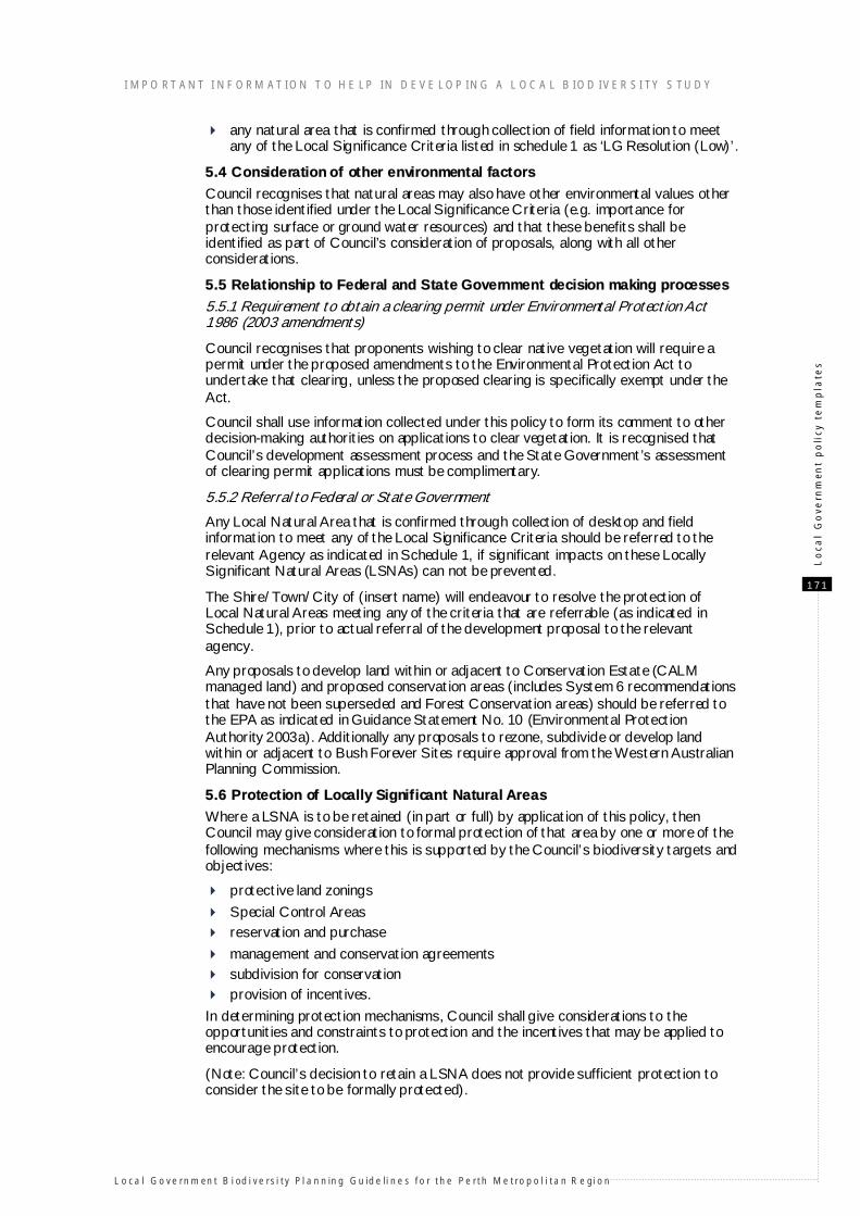
Schedule 1: Local Significance Criteria and Referral Responsibilities
Criteria Refer to DEH
Refer to EPA/ DoE
Refer to CALM
Refer to SRT
Refer to
WAPC/DPI
LG Resolution (High)
LG Resolution (Low)
1. Representation a) Regional
i) recognised International, National, State or Regional Conservation Value (outside Bush Forever Sites and CALM Managed Estate), for example, System 6 Areas in the Jarrah Forest outside CALM Managed Estate
X X X
ii) of an ecological community with only 1500 ha or 30% or less (whichever is the greater) remaining in the IBRA subregion (Swan Coastal Plain)
X
ii) of an ecological community with only 1500 ha or 30% or less (whichever is the greater) remaining in the IBRA subregion (Jarrah Forest)
X
iii) large (greater than 20 ha), viable natural areas in good or better condition of an ecological community with more than 30% remaining within the IBRA subregion
X
iv) of an ecological community with only 1500 ha or 15% or less (whichever is the greater) protected for conservation in the Jarrah Forest IBRA subregion
X
v) Of an ecological community with only 400 ha or 10% or less (whichever is the greater) protected for conservation in Bush Forever Study Area
X
1. Representation b) Local
i) of an ecological community with 10% or less remaining within Local Government area
X
ii) of an ecological community with 30% or less remaining within Local Government area
X
iii) large, viable natural areas in good or better condition of an ecological community with more than 30% remaining within Local Government area
X
2. Diversity
i) natural area in good or better condition that contains upland and wetland structural plant communities
X
3. Rarity
i) of an ecological community with only 1500 ha or 10% or less (whichever is the greater) remaining in IBRA subregion
X
ii) of an ecological community with only 400 ha or 10% or less (whichever is the greater) remaining in Bush Forever Study Area
X
I MPO RT ANT I NF ORM AT ION T O H E LP IN DE VE LOP ING A L OCA L B IOD IVE R SI TY S TUDY
L o ca l Go ve rn m en t B i od i ve rsi ty Pl a n n in g Gu id e li n e s fo r th e Pe rth Me tro p o l i ta n R e gi o n
1 7 3
Lo
cal
Go
vern
men
t p
oli
cy t
em
pla
tes
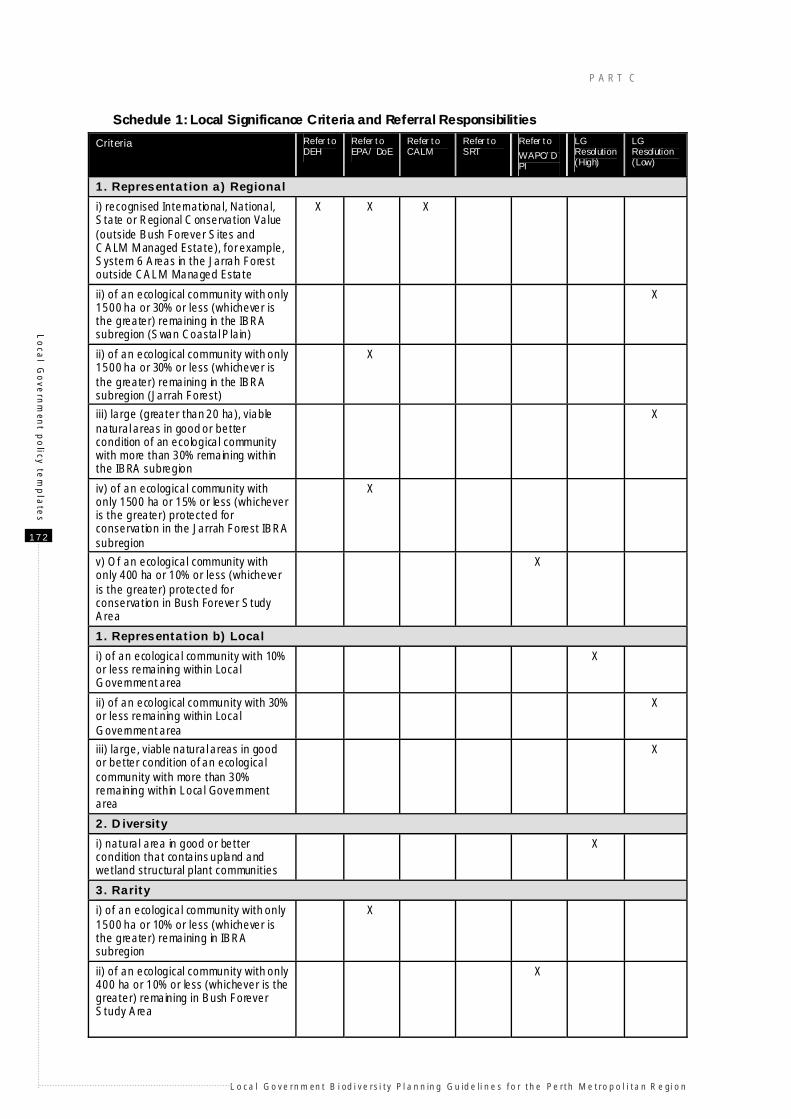
Criteria Refer to DEH
Refer to EPA/ DoE
Refer to CALM
Refer to SRT
Refer to
WAPC/DPI
LG Resolution (High)
LG Resolution (Low)
iii) contains a threatened ecological community (TEC)
X X X
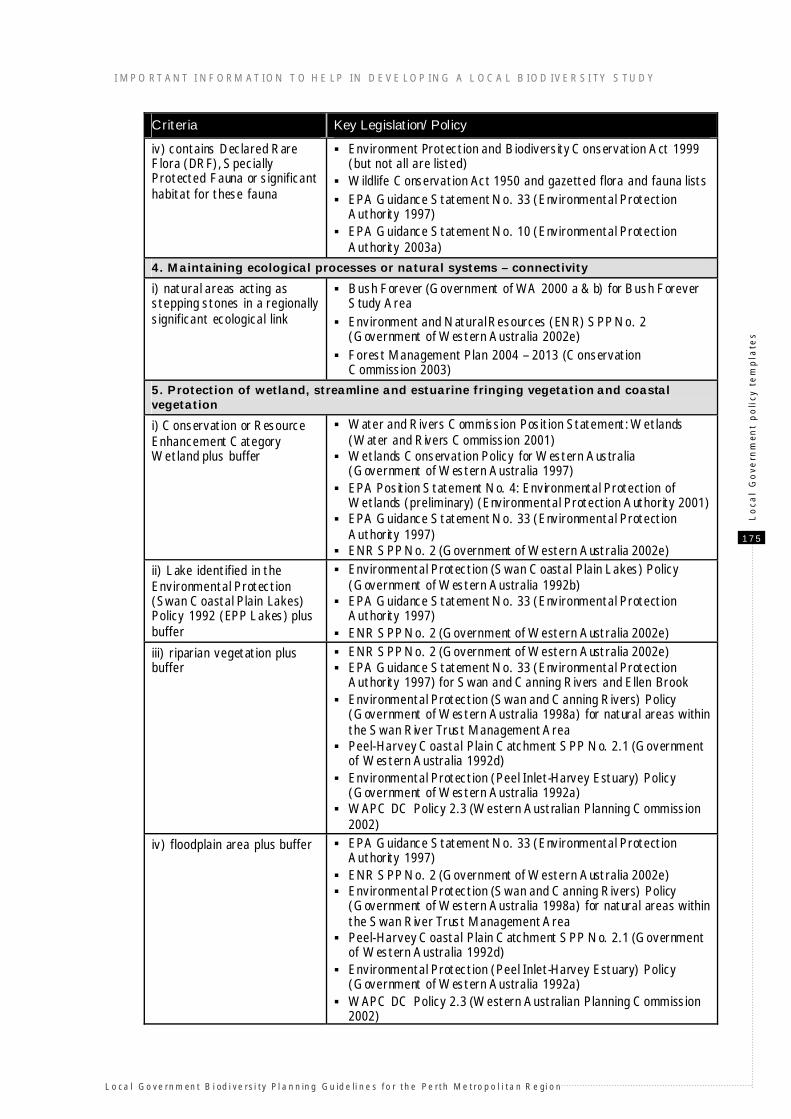
iv) contains Declared Rare Flora (DRF), Specially Protected Fauna or significant habitat for these fauna
X X X
v) contains Priority or other significant flora or fauna or significant habitat for these fauna
X X X
4. Maintaining ecological processes or natural systems – connectivity
i) natural areas acting as stepping stones in a regionally significant ecological link
X
ii) natural areas acting as stepping stones in a locally significant ecological link
X
5. Protection of wetland, streamline and estuarine fringing vegetation and coastal vegetation
i) Conservation or Resource Enhancement Category Wetland plus buffer
X
ii) EPP Lake plus buffer X
iii) riparian vegetation plus buffer X
iv) floodplain area plus buffer X
v) estuarine fringing vegetation plus buffer
X
vi)coastal vegetation on foredunes and secondary dunes
X
Note:
all proposals to clear native vegetation require a permit under the Environmental Protection Act, unless the clearing is specifically exempt under that Act
Local Government should endeavour to resolve the protection of Local Natural Areas meeting any of the criteria that are referrable prior to actual referral of the development proposal to the relevant agency.
Key to table: Criteria - Describes the Local Significance Criteria against which field information collected
on Local Natural Area is assessed. Refer to DEH - X indicates that LNA that meet these criteria are referrable to the
Department of Environment and Heritage if significant impacts can not be prevented. Refer to CALM - X indicates that LNA that meet these criteria are referrable to the
Department of Conservation and Land Management if significant impacts can not be prevented.
Refer to SRT - X indicates that LNA that meet these criteria are referrable to the Swan River Trust if significant impacts can not be prevented.
Referral to EPA/DoE- X indicates that LNA that meet these criteria are referrable to the Environmental Protection Authority/Department of Environment if significant impacts can not be prevented.
Referral to WAPC/DPI - X indicates that LNA that meet these criteria are referrable to the Western Australian Planning Commission/Department for Planning and Infrastructure if significant impacts can not be prevented.
LG Resolution (High) - X indicates that LNA that meet these criteria are a high priority for retention and protection and it is predominantly Local Government responsibility for providing the justification for the retention and protection of the natural area.
LG Resolution (Low) - X indicates that LNA that meet these criteria are a lower priority for retention and protection and it is predominantly Local Government responsibility for providing the justification for the retention and protection of the natural area.
P A R T C
L o ca l Go ve rn m en t B i od i ve rsi ty Pl a n n in g Gu id e li n e s fo r th e Pe rth Me tro p o l i ta n R e gi o n
1 7 4
Lo
cal G
ove
rnm
ent p
olicy te
mp
late
s
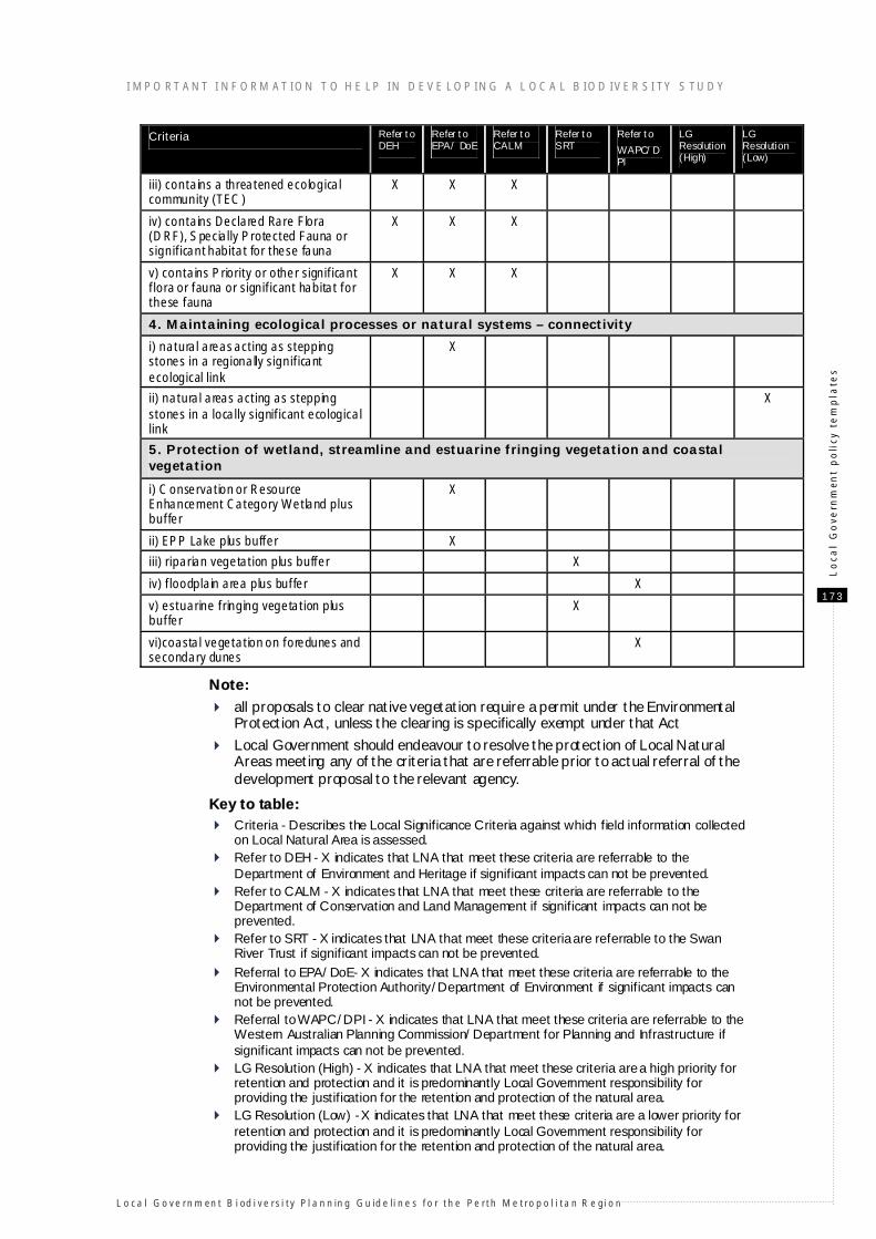
Schedule 2: State and Federal Government legislation and policy supporting Local Significance Criteria
Criteria Key Legislation/Policy
1. Representation a) Regional
i) Recognised International, National, State or Regional Conservation Value (outside Bush Forever Sites and CALM Managed Estate), for example, System 6 Areas in the Jarrah Forest outside CALM Managed Estate
Environment Protection and Biodiversity Conservation Act (EPBC Act) for some areas
EPA Guidance Statement No. 33 (Environmental Protection Authority 1997)
Forest Management Plan 2004 – 2013 (Conservation Commission 2003) for proposed conservation reserves
System 6 recommendations in the Jarrah Forest outside CALM Managed Estate (Department of Conservation and Environment 1983)
EPA Guidance Statement No. 10 (Environmental Protection Authority 2003a)
Environment and Natural Resources (ENR) SPP No. 2 (Government of Western Australia 2002e)
ii) of an ecological community with only 1500 ha or 30% or less (whichever is the greater) remaining in the IBRA subregion
National Targets and Objectives for Biodiversity Conservation 2001–2005 (Commonwealth of Australia 2001b)
EPA Guidance Statement No. 10 (Environmental Protection Authority 2003a)
iv) of an ecological community with only 1500 ha or 15% or less (whichever is the greater) protected for conservation in the Jarrah Forest IBRA subregion
Forest Management Plan 2004 – 2013 (Conservation Commission 2003)
EPA Guidance Statement No. 10 (Environmental Protection Authority 2003a)
v) of an ecological community with only 400 ha or 10% or less (whichever is the greater) protected for conservation in Bush Forever Study Area
Bush Forever (Government of WA 2000 a & b) EPA Guidance Statement No. 10 (Environmental Protection
Authority 2003a)
3. Rarity
i) of an ecological community with only 1500 ha or 10% or less (whichever is the greater) remaining in the Interim Bioregionalisation of Australia (IBRA) subregion
National Targets and Objectives for Biodiversity Conservation 2001–2005 (Commonwealth of Australia 2001b)
EPA Guidance Statement No. 10 (Environmental Protection Authority 2003a)
ii) of an ecological community with only 400 ha or 10% or less (whichever is the greater) remaining in Bush Forever Study Area
Bush Forever (Government of WA 2000 a & b) EPA Guidance Statement No. 10 (Environmental Protection
Authority 2003a)
iii) contains a threatened ecological community (TEC)
Environment Protection and Biodiversity Conservation Act 1999 (but only for the most threatened TECs)
CALM Draft Policy Statement No. 9 (Department of Conservation and Land Management 2003a) and database of TECs
EPA Guidance Statement No. 33 (Environmental Protection Authority 1997)
EPA Guidance Statement No. 10 (Environmental Protection Authority 2003a)
I MPO RT ANT I NF ORM AT ION T O H E LP IN DE VE LOP ING A L OCA L B IOD IVE R SI TY S TUDY
L o ca l Go ve rn m en t B i od i ve rsi ty Pl a n n in g Gu id e li n e s fo r th e Pe rth Me tro p o l i ta n R e gi o n
1 7 5
Lo
cal
Go
vern
men
t p
oli
cy t
em
pla
tes
Criteria Key Legislation/Policy
iv) contains Declared Rare Flora (DRF), Specially Protected Fauna or significant habitat for these fauna
Environment Protection and Biodiversity Conservation Act 1999 (but not all are listed)
Wildlife Conservation Act 1950 and gazetted flora and fauna lists EPA Guidance Statement No. 33 (Environmental Protection
Authority 1997) EPA Guidance Statement No. 10 (Environmental Protection
Authority 2003a)
4. Maintaining ecological processes or natural systems – connectivity
i) natural areas acting as stepping stones in a regionally significant ecological link
Bush Forever (Government of WA 2000 a & b) for Bush Forever Study Area
Environment and Natural Resources (ENR) SPP No. 2 (Government of Western Australia 2002e)
Forest Management Plan 2004 – 2013 (Conservation Commission 2003)
5. Protection of wetland, streamline and estuarine fringing vegetation and coastal vegetation
i) Conservation or Resource Enhancement Category Wetland plus buffer
Water and Rivers Commission Position Statement: Wetlands (Water and Rivers Commission 2001)
Wetlands Conservation Policy for Western Australia (Government of Western Australia 1997)
EPA Position Statement No. 4: Environmental Protection of Wetlands (preliminary) (Environmental Protection Authority 2001)
EPA Guidance Statement No. 33 (Environmental Protection Authority 1997)
ENR SPP No. 2 (Government of Western Australia 2002e)
ii) Lake identified in the Environmental Protection (Swan Coastal Plain Lakes) Policy 1992 (EPP Lakes) plus buffer
Environmental Protection (Swan Coastal Plain Lakes) Policy (Government of Western Australia 1992b)
EPA Guidance Statement No. 33 (Environmental Protection Authority 1997)
ENR SPP No. 2 (Government of Western Australia 2002e)
iii) riparian vegetation plus buffer
ENR SPP No. 2 (Government of Western Australia 2002e) EPA Guidance Statement No. 33 (Environmental Protection
Authority 1997) for Swan and Canning Rivers and Ellen Brook Environmental Protection (Swan and Canning Rivers) Policy
(Government of Western Australia 1998a) for natural areas within the Swan River Trust Management Area
Peel-Harvey Coastal Plain Catchment SPP No. 2.1 (Government of Western Australia 1992d)
Environmental Protection (Peel Inlet-Harvey Estuary) Policy (Government of Western Australia 1992a)
WAPC DC Policy 2.3 (Western Australian Planning Commission 2002)
iv) floodplain area plus buffer EPA Guidance Statement No. 33 (Environmental Protection Authority 1997)
ENR SPP No. 2 (Government of Western Australia 2002e) Environmental Protection (Swan and Canning Rivers) Policy
(Government of Western Australia 1998a) for natural areas within the Swan River Trust Management Area
Peel-Harvey Coastal Plain Catchment SPP No. 2.1 (Government of Western Australia 1992d)
Environmental Protection (Peel Inlet-Harvey Estuary) Policy (Government of Western Australia 1992a)
WAPC DC Policy 2.3 (Western Australian Planning Commission 2002)
P A R T C
L o ca l Go ve rn m en t B i od i ve rsi ty Pl a n n in g Gu id e li n e s fo r th e Pe rth Me tro p o l i ta n R e gi o n
1 7 6
Lo
cal G
ove
rnm
ent p
olicy te
mp
late
s
Criteria Key Legislation/Policy
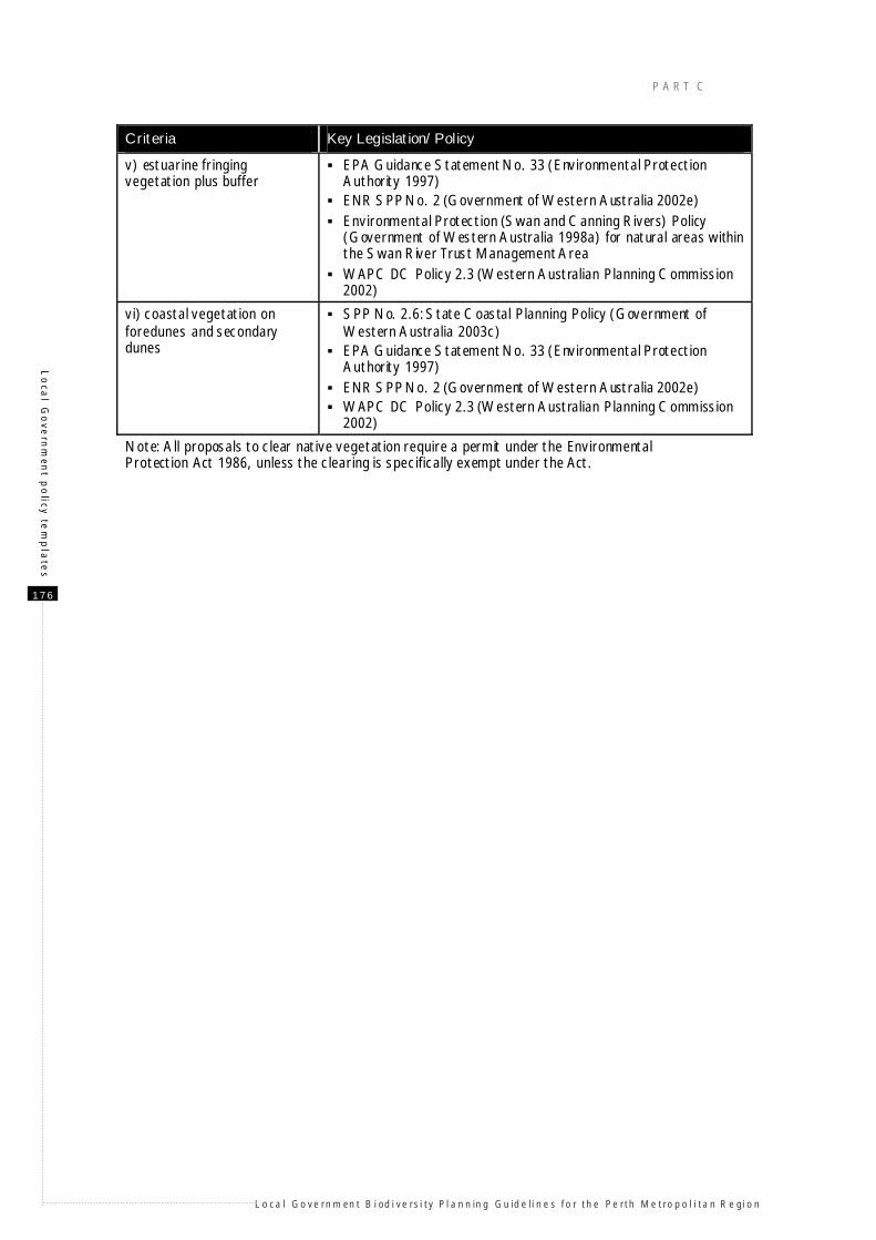
v) estuarine fringing vegetation plus buffer
EPA Guidance Statement No. 33 (Environmental Protection Authority 1997)
ENR SPP No. 2 (Government of Western Australia 2002e) Environmental Protection (Swan and Canning Rivers) Policy
(Government of Western Australia 1998a) for natural areas within the Swan River Trust Management Area
WAPC DC Policy 2.3 (Western Australian Planning Commission 2002)
vi) coastal vegetation on foredunes and secondary dunes
SPP No. 2.6: State Coastal Planning Policy (Government of Western Australia 2003c)
EPA Guidance Statement No. 33 (Environmental Protection Authority 1997)
ENR SPP No. 2 (Government of Western Australia 2002e) WAPC DC Policy 2.3 (Western Australian Planning Commission
2002)
Note: All proposals to clear native vegetation require a permit under the Environmental Protection Act 1986, unless the clearing is specifically exempt under the Act.
I MPO RT ANT I NF ORM AT ION T O H E LP IN DE VE LOP ING A L OCA L B IOD IVE R SI TY S TUDY
L o ca l Go ve rn m en t B i od i ve rsi ty Pl a n n in g Gu id e li n e s fo r th e Pe rth Me tro p o l i ta n R e gi o n
1 7 7
Lo
cal
Go
vern
men
t p
oli
cy t
em
pla
tes
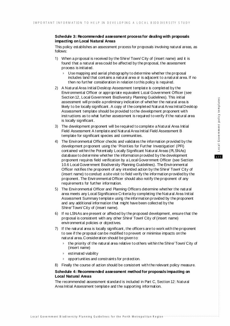
Schedule 3: Recommended assessment process for dealing with proposals impacting on Local Natural Areas
This policy establishes an assessment process for proposals involving natural areas, as follows:
1) When a proposal is received by the Shire/Town/City of (insert name) and it is found that a natural area could be affected by the proposal, the assessment process is initiated.
Use mapping and aerial photography to determine whether the proposal includes land that contains a natural area or is adjacent to a natural area. If no then no further consideration in relation to this policy is required.
2) A Natural Area Initial Desktop Assessment template is completed by the Environmental Officer or appropriate equivalent Local Government Officer (see Section 12, Local Government Biodiversity Planning Guidelines). This initial assessment will provide a preliminary indication of whether the natural area is likely to be locally significant. A copy of the completed Natural Area Initial Desktop Assessment template should be provided to the development proponent with instructions as to what further assessment is required to verify if the natural area is locally significant.
3) The development proponent will be required to complete a Natural Area Initial Field Assessment A template and Natural Area Initial Field Assessment B template for significant species and communities.
4) The Environmental Officer checks and validates the information provided by the development proponent using the ‘Priorities for Further Investigation’ (PFI) contained within the Potentially Locally Significant Natural Areas (PLSNAs) database to determine whether the information provided by the development proponent requires field verification by a Local Government Officer (see Section 10.6 Local Government Biodiversity Planning Guidelines). The Environmental Officer notifies the proponent of any intended action by the Shire/Town/City of (insert name) to conduct a site visit to field verify the information provided by the proponent. The Environmental Officer should also notify the proponent of any requirements for further information.
5) The Environmental Officer and Planning Officers determine whether the natural area meets any Local Significance Criteria by completing the Natural Area Initial Assessment Summary template using the information provided by the proponent and any additional information that might have been collected by the Shire/Town/City of (insert name).
6) If no LSNAs are present or affected by the proposed development, ensure that the proposal is consistent with any other Shire/Town/City of (insert name) environmental policies or objectives.
7) If the natural area is locally significant, the officers are to work with the proponent to see if the proposal can be modified to prevent or minimise impacts on the natural area. Consideration should be given to:
the priority of the natural area relative to others within the Shire/Town/City of (insert name)
estimated viability opportunities and constraints for protection.
8) Finally the course of action should be consistent with the relevant policy measure.
Schedule 4: Recommended assessment method for proposals impacting on Local Natural Areas The recommended assessment standard is included in Part C, Section 12: Natural Area Initial Assessment template and the supporting information.
P A R T C
L o ca l Go ve rn m en t B i od i ve rsi ty Pl a n n in g Gu id e li n e s fo r th e Pe rth Me tro p o l i ta n R e gi o n
1 7 8
Lo
cal G
ove
rnm
ent p
olicy te
mp
late
s
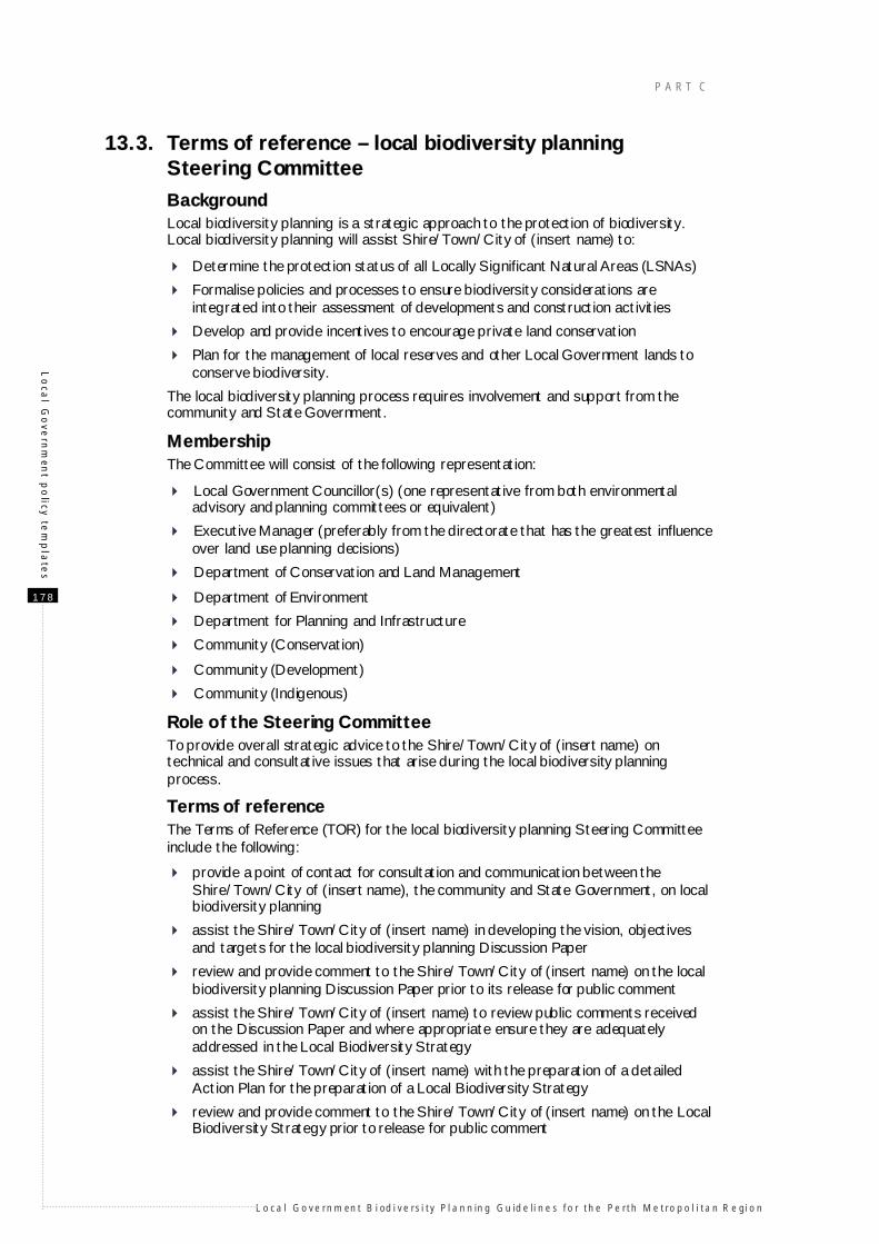
13.3. Terms of reference – local biodiversity planning Steering Committee
Background Local biodiversity planning is a strategic approach to the protection of biodiversity. Local biodiversity planning will assist Shire/Town/City of (insert name) to:
Determine the protection status of all Locally Significant Natural Areas (LSNAs)
Formalise policies and processes to ensure biodiversity considerations are integrated into their assessment of developments and construction activities
Develop and provide incentives to encourage private land conservation
Plan for the management of local reserves and other Local Government lands to conserve biodiversity.
The local biodiversity planning process requires involvement and support from the community and State Government.
Membership The Committee will consist of the following representation:
Local Government Councillor(s) (one representative from both environmental advisory and planning committees or equivalent)
Executive Manager (preferably from the directorate that has the greatest influence over land use planning decisions)
Department of Conservation and Land Management
Department of Environment
Department for Planning and Infrastructure
Community (Conservation)
Community (Development)
Community (Indigenous)
Role of the Steering Committee To provide overall strategic advice to the Shire/Town/City of (insert name) on technical and consultative issues that arise during the local biodiversity planning process.
Terms of reference The Terms of Reference (TOR) for the local biodiversity planning Steering Committee include the following:
provide a point of contact for consultation and communication between the Shire/Town/City of (insert name), the community and State Government, on local biodiversity planning
assist the Shire/Town/City of (insert name) in developing the vision, objectives and targets for the local biodiversity planning Discussion Paper
review and provide comment to the Shire/Town/City of (insert name) on the local biodiversity planning Discussion Paper prior to its release for public comment
assist the Shire/Town/City of (insert name) to review public comments received on the Discussion Paper and where appropriate ensure they are adequately addressed in the Local Biodiversity Strategy
assist the Shire/Town/City of (insert name) with the preparation of a detailed Action Plan for the preparation of a Local Biodiversity Strategy
review and provide comment to the Shire/Town/City of (insert name) on the Local Biodiversity Strategy prior to release for public comment
I MPO RT ANT I NF ORM AT ION T O H E LP IN DE VE LOP ING A L OCA L B IOD IVE R SI TY S TUDY
L o ca l Go ve rn m en t B i od i ve rsi ty Pl a n n in g Gu id e li n e s fo r th e Pe rth Me tro p o l i ta n R e gi o n
1 7 9
Lo
cal
Go
vern
men
t p
oli
cy t
em
pla
tes
assist the Shire/Town/City of (insert name) to review public comments received on the Strategy and where appropriate ensure that any issues arising are adequately resolved
support the Shire/Town/City of (insert name) with implementation of the Strategy through:
facilitating regular review of the progress of the Strategy
representation on Incentives Strategy Assessment Panel.
P A R T C
L o ca l Go ve rn m en t B i od i ve rsi ty Pl a n n in g Gu id e li n e s fo r th e Pe rth Me tro p o l i ta n R e gi o n
1 8 0
A g
uid
e to
the
Pla
nnin
g S
ystem
14. A guide to the Planning System By Gary Middle, Environmental Planning Consultant
14.1. What is Planning? The land use planning system (‘Planning’) is the general process of allocating land for a general use and then providing ongoing controls for specific land uses. Planning is necessary because the free market does not always deliver the optimum use of land and can, instead, cause conflicts between land uses.
The Planning process can be complex and highly technical, which can be quite confusing to the untrained person. This Guide is an attempt to explain and make sense of Planning.
The key questions to be answered are:
who does Planning? what are the tools of Planning? what are the steps in the process? what are the levels of Planning?
14.2. Who does Planning? The Western Australian Planning Commission (WAPC) and Local Governments have legal responsibility for Planning in Western Australia, under the ultimate control of the Minister for Planning. The WAPC is a statutory authority set up under its own Act. Its members, including the Chairman, are part-time. The Department for Planning and Infrastructure (DPI) provides administrative support to the WAPC as well as having delegated authority to make some Planning decisions, mostly subdivisions. Planning by Local Government is the legal responsibility of the elected members (that is, Council), and most Local Governments employ professional planners to give advice to Council on Planning matters.
14.3. Planning tools
Overview Planners use the following tools or mechanisms to control the Planning process:
Strategies Structure Plans Statutory Planning Schemes Policies Conditions.
Strategies Strategies are documents applied to a particular region and developed and agreed to by a range of State Government agencies and affected Local Governments. Strategies show how those agencies will co-operate on land use and development and have a 10-year to 30-year time frame.
Structure Plans Structure plans show a much greater level of detail about how the affected land is to be developed and have shorter time frames than Strategies, from five to 10 years. Structure plans flag which areas of land are to be used for the following broad uses:
urban rural industrial regional open space regional reserves.
I MPO RT ANT I NF ORM AT ION T O H E LP IN DE VE LOP ING A L OCA L B IOD IVE R SI TY S TUDY
L o ca l Go ve rn m en t B i od i ve rsi ty Pl a n n in g Gu id e li n e s fo r th e Pe rth Me tro p o l i ta n R e gi o n
1 8 1
A g
uid
e t
o t
he
Pla
nni
ng
Sys
tem
Whilst a structure plan is not a statutory document (that is, it does not have the weight of law), once a plan has been through a public consultation process and received the endorsement of a planning agency it is seen as an official blueprint for what will happen in the subsequent statutory Planning process.
Statutory Planning Schemes Statutory Planning Schemes are used to give effect to structure plans by allocating pieces of land as a zone or a reserve. Zones are used for private land and reserves are used for Crown land (publicly owned land). Generally, a Scheme is made up of two parts:
maps that show the Zoning or Reservation status of all of the land covered by a Scheme
Scheme text that describes in some detail what specific land uses are allowed within each zone. Reserves are usually allocated for a specific public purpose for a particular Government agency and Scheme text is not normally required.
Schemes can cover a whole Local Government area (a Town Planning Scheme [TPS]) or a specific area (for example, District Planning Scheme).
The statutory nature of a Scheme means that it can take several years to prepare from scratch, and up to 18 months to amend a portion of it.
Policies It is not possible to make a Scheme so comprehensive that it covers all of the matters that need to be considered when making Planning decisions. Further, some issues are highly complex and a more flexible approach may be required than allowed for in Statutory Schemes. Issue-specific Planning policies are developed in these cases as a complement to the Scheme.
Local policies are, in effect, guides to how future Planning decisions will be made and are not fixed sets of binding rules.
Policies at the regional level (that is, Statements of Planning Policy [SPPs] developed under Section 5AA of the Town Planning and Development Act 1928 [TPD Act]) tend to be more specific and are used to guide Local Governments in how they should amend their TPSs to deal with a particular regionally significant issue (for example, protecting groundwater in a public water supply area).
Conditions A Condition is a legal requirement on a land owner or developer to carry out certain actions as part of subdivision or development. Conditions can relate to but not limited to:
providing public open space free of cost providing a sewerage system building a suitable drainage system
defining where a building can be located within a particular lot how an industrial plant is to be designed.
Conditions have to be complied with before subdivision or development is given final approval. Whilst Council can set conditions related to the ongoing use of the land related to a development application (e.g operating hours), they cannot for subdivisions. This can be done through the provisions of the TPS or through the issuing of a Licence (for example, under Part V of the Environmental Protection Act 1986).
14.4. The Planning Steps In Western Australia, Planning is highly organised and structured, with four broad steps:
strategic planning – a process of showing future intended broad uses for a large area of land

P A R T C
L o ca l Go ve rn m en t B i od i ve rsi ty Pl a n n in g Gu id e li n e s fo r th e Pe rth Me tro p o l i ta n R e gi o n
1 8 2
A g
uid
e to
the
Pla
nnin
g S
ystem
land zoning or reservation – a legally binding (statutory) process of allocating a specific piece of land for a specific use(s) and setting broad controls on those uses
subdivision – the formal process of arranging or rearranging land into parcels so that the future land use can be carried out
development – the formal process of giving approval for a specific use of a lot (for example, building a house, building a factory or creating a market garden).
It should be noted that in most cases development of land follows the above orderly hierarchical process. There are, however, two complicating factors. Firstly, the subdivision and development processes are not legally linked to the land zoning process, and a land owner can apply and be granted permission to subdivide or develop a parcel of land ahead of the land being rezoned. In practice this rarely happens but when it does it can cause problems in that appropriate land use controls would not be in place to control the land following the subdivision or development. Secondly, there can be strategic planning and land zoning at both the regional and local levels, and they can add a layer of complexity to Planning, as discussed in the next section.
14.5. Planning Levels
Overview Sitting above all the levels of Planning is the WAPC's State Planning Strategy, which sets out the broad framework and objectives for Planning in Western Australia. Underneath this state-wide Strategy, Planning is done at both the regional and local level. The WAPC does all of the regional Planning (corridor Planning in Perth and country regional planning, for example, Bunbury–Wellington) whereas Local Governments tend to do Planning at the local level.
Strategic Planning – regional and local Strategic Planning at the regional level covers a large area of land and its recommendations tend to be broad scale. As discussed above, there are two types of documents produced at this level of planning: Strategies and Structure Plans.
The WAPC has produced a range of regional strategies and plans but has not applied a uniform naming system. For example, the Bunbury–Wellington Region Plan is considered a Strategy. Strategies have a longer time frame than Plans but it does not always mean that Strategies cover a larger geographic area. For example, WAPC has produced a South West Corridor Structure Plan for the whole area from Fremantle to Rockingham, but it has also produced regional strategies for Kwinana and Fremantle, sub-areas within the South West Corridor.
Local Governments follow up regional strategic Planning with their own, more specific and usually shorter term local area planning that flags more specific land uses based on the regional categories. For example, under an ‘urban’ regional use a local plan will show proposed zoning for residential areas, shopping centres, primary schools and public open space.
Local Governments adopt different names for these local plans including district structure plans, local area plans and neighbourhood plans. These plans can also be prepared at different points in the planning process. District structure plans cover a large area and are usually required before rezoning occurs at the local level, particularly where the area affected involves several land owners wanting to develop their land. This will allow for the orderly allocation of public open space, shopping centres, schools and so on.
In other cases local planning will be carried out during or after the rezoning process, depending on the nature of the zoning, the size of the parcel of land and the ownership pattern.
Schemes – regional and local Schemes can be regional (Region Schemes) or local (TPSs). As with Strategic Planning, Region Schemes are broader in the zoning applied whereas TPSs use more specific zoning and more detailed provisions.
I MPO RT ANT I NF ORM AT ION T O H E LP IN DE VE LOP ING A L OCA L B IOD IVE R SI TY S TUDY
L o ca l Go ve rn m en t B i od i ve rsi ty Pl a n n in g Gu id e li n e s fo r th e Pe rth Me tro p o l i ta n R e gi o n
1 8 3
A g
uid
e t
o t
he
Pla
nni
ng
Sys
tem
Only Perth and Peel have Region Schemes and Bunbury has a Region Scheme in preparation. The Region Scheme for Perth is called the Metropolitan Region Scheme or MRS.
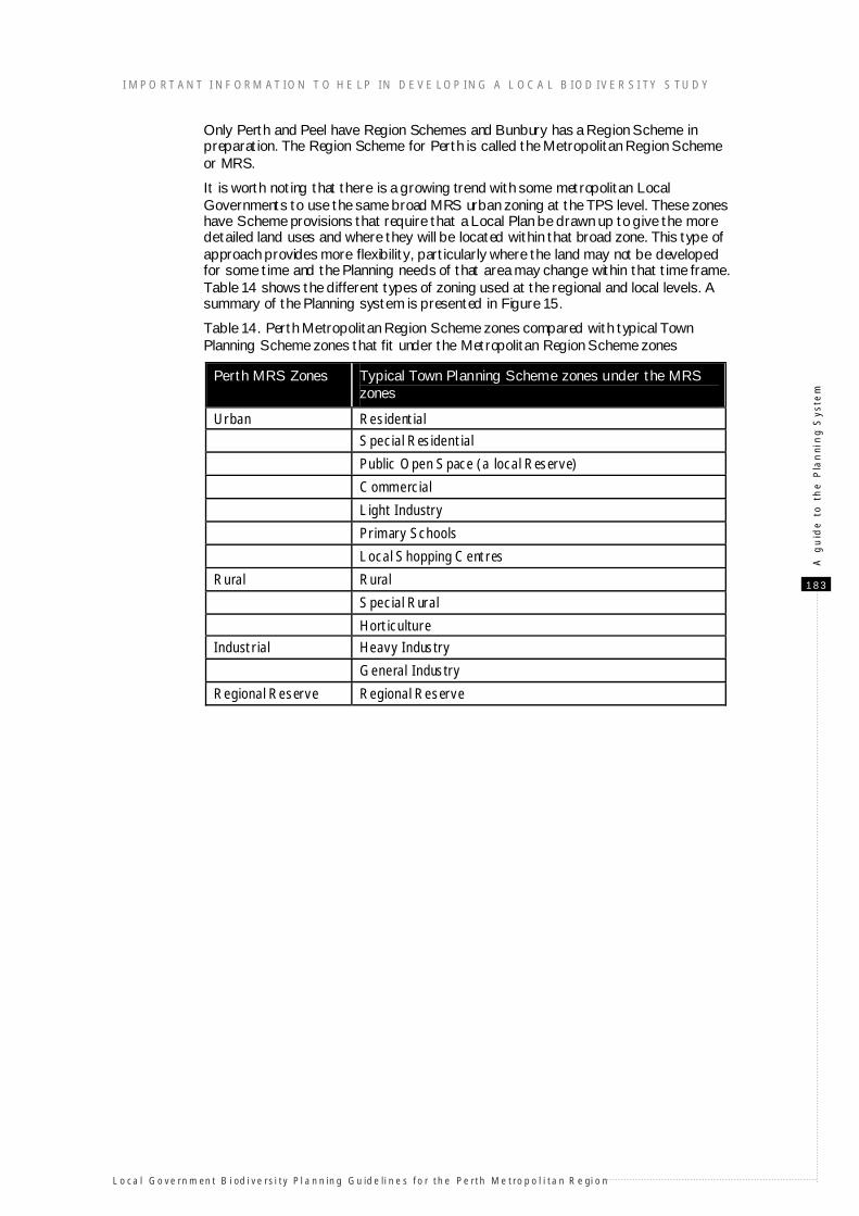
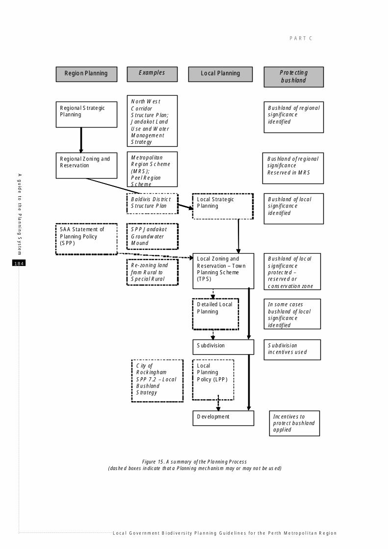
It is worth noting that there is a growing trend with some metropolitan Local Governments to use the same broad MRS urban zoning at the TPS level. These zones have Scheme provisions that require that a Local Plan be drawn up to give the more detailed land uses and where they will be located within that broad zone. This type of approach provides more flexibility, particularly where the land may not be developed for some time and the Planning needs of that area may change within that time frame. Table 14 shows the different types of zoning used at the regional and local levels. A summary of the Planning system is presented in Figure 15.
Table 14. Perth Metropolitan Region Scheme zones compared with typical Town Planning Scheme zones that fit under the Metropolitan Region Scheme zones
Perth MRS Zones Typical Town Planning Scheme zones under the MRS zones
Urban Residential
Special Residential
Public Open Space (a local Reserve)
Commercial
Light Industry
Primary Schools
Local Shopping Centres
Rural Rural
Special Rural
Horticulture
Industrial Heavy Industry
General Industry
Regional Reserve Regional Reserve
P A R T C
L o ca l Go ve rn m en t B i od i ve rsi ty Pl a n n in g Gu id e li n e s fo r th e Pe rth Me tro p o l i ta n R e gi o n
1 8 4
A g
uid
e to
the
Pla
nnin
g S
ystem
Region Planning Local Planning
Regional Strategic Planning
Regional Zoning and Reservation
Local Strategic Planning
Local Zoning and Reservation – Town Planning Scheme (TPS)
Detailed Local Planning
Subdivision
Development
Examples
North West Corridor Structure Plan;Jandakot Land Use and Water Management Strategy
Metropol itan Region Scheme (MRS);Peel Region Scheme
5AA Statement of Planning Policy (SPP)
Local Planning Policy (LPP)
Protecting bushland
SPP Jandakot Groundwater Mound
Re-zoning land from Rural to Special Rural
Bushland of regional significance identified
Bushland of regional signi ficance Reserved in MRS
Bushland of local significance identified
Bushland of local s ignificance protected –reserved or conservation zone
Subdivision incentives used
Incentives to protect bushland appl ied
In some cases bushland of local significance identified
Baldivis District Structure Plan
City of Rockingham SPP 7.2 – Local Bushland Strategy
Figure 15. A summary of the Planning Process (dashed boxes indicate that a Planni ng mechanism may or may not be us ed)
I MPO RT ANT I NFORM AT ION T O HE LP IN DEVE LOP ING A L OCA L B IOD IVER SI TY S TUDY
L o ca l Go ve rn m en t B i od i ve rsi ty Pl a n n in g Gu id e li n e s fo r th e Pe rth Me tro p o l i ta n R e gi o n
1 8 5
A g
uid
e t
o t
he
Pla
nni
ng
Sys
tem
14.6. The role of the Environmental Protection Authority The Environmental Protection Authority (EPA) is a statutory authority that operates under the Environmental Protection Act 1986 with the broad objective of protecting Western Australia’s environment. The EPA becomes involved in the planning process in the situations outlined below.
Town Planning Schemes and Scheme Amendments All Town Planning Schemes and amendments (both the Town Planning Scheme [TPS] and Metropolitan Region Scheme [MRS] have to be referred to the EPA under Section 48A of Environmental Protection Act. If the EPA formally assesses a scheme or amendment to a scheme, both the Planning and Infrastructure and Environment and Heritage Ministers have to agree on conditions before approval can be given (Environmental Protection Authority 2002).
Proposals to subdivide or develop Where there is a proposal to subdivide or develop land the Environmental Protection Act requires that the decision making authority (in the case of subdivisions it is the WAPC and for most development applications it is Local Government) must refer the proposal to the EPA. If the EPA considers that the proposal is likely to have a significant effect on the environment it can then require a Environmental Impact Assessment (EIA) to be undertaken.
Special referral requirements apply to a proposal that is an application for the approval of any development or subdivision under what is known as an assessed scheme. Usually, an assessed scheme will be a planning scheme or planning scheme amendment that has been referred to the EPA and is the subject of either a level of assessment set by the EPA as “not assessed” or a statement of environmental conditions set by the Minister for the Environment following the formal EIA process. An assessed scheme may also be a scheme that is required to be made following an amendment to a regional scheme (MRS) where the amendment to the regional scheme is itself an assessed scheme (Environmental Protection Authority 2002).
A proposal under an assessed scheme that is likely to have a significant effect on the environment requires referral to the EPA only if it does not comply with the assessed scheme, or if the proposal raises environmental issues that were not considered by the EPA when it set the level of assessment for the scheme (Section 48I of the Environmental Protection Act 1986).
P A R T C
L o ca l Go ve rn m en t B i od i ve rsi ty Pl a n n in g Gu id e li n e s fo r th e Pe rth Me tro p o l i ta n R e gi o n
1 8 6
Th
e P
lann
ing
Syste
m a
nd
pro
tectio
n m
ech
anism
s for L
SN
A’s
15. The Planning System and protection mechanisms for Locally Significant Natural Areas
By Gary Middle, Environmental Planning Consultant
This paper deals with measures that Local Governments can use to protect Locally Significant Natural Areas (LSNAs). Mechanisms in the planning system used to protect Regionally significant natural areas (for example, Bush Forever Sites) are covered in the Bush Forever policy (Government of Western Australia 2000a; 2000b; 2000c) and the Draft Statement of Planning Policy: Bushland Policy for the Perth Metropolitan Area (Western Australian Planning Commission, in preparation).
15.1. Summary of protection mechanisms The formal mechanisms available to Local Government to protect LSNAs are:
protective land zonings
reservation and purchase management and conservation agreements subdivision for conservation
provision of incentives for LSNA protection self-funding arrangements
conditions on approval of application refusal of an application.
In addition, Local Government can:
provide additional resources for management create education and training for land owners
encourage community involvement in the management of protected LSNAs monitor and report on the status for LSNAs protected in the area, for example
through State of the Environment reporting.
Other than ‘reservation’, it is unlikely that any one mechanism will be used on its own to protect privately owned natural areas. For example, land owners will not normally agree to a Conservation Zoning on their land unless some additional incentives are offered such as rate relief. Some of the case studies in this section demonstrate use of more than one mechanism.
15.1.1. Protection and retention mechanisms
Special Rural Zones Special Rural Zones have been used extensively to control large lot subdivision in rural areas, and in many cases the land involved contains bushland and other natural areas. The main purpose of these zones is to create a rural living environment rather than to specifically protect natural areas. Special Rural Zones normally have Town Planning Scheme (TPS) provisions that prevent clearing of natural areas outside prescribed building envelopes, access tracks, firebreaks and fire access tracks.
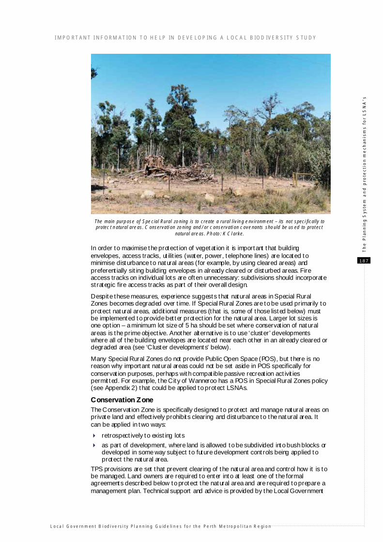
I MPO RT ANT I NFORM AT ION T O HE LP IN DEVE LOP ING A L OCA L B IOD IVER SI TY S TUDY
L o ca l Go ve rn m en t B i od i ve rsi ty Pl a n n in g Gu id e li n e s fo r th e Pe rth Me tro p o l i ta n R e gi o n
1 8 7
Th
e P
lan
nin
g S
yste
m a
nd
pro
tect
ion
me
chan
ism
s fo
r L
SN
A’s
The main purpose of Special Rural zoning is to create a rural living environment – its not speci fically to protect natural areas. Conservati on zoning and/or conservati on covenants should be us ed to protect
natural areas. Photo: K Clarke.
In order to maximise the protection of vegetation it is important that building envelopes, access tracks, utilities (water, power, telephone lines) are located to minimise disturbance to natural areas (for example, by using cleared areas) and preferentially siting building envelopes in already cleared or disturbed areas. Fire access tracks on individual lots are often unnecessary: subdivisions should incorporate strategic fire access tracks as part of their overall design.
Despite these measures, experience suggests that natural areas in Special Rural Zones becomes degraded over time. If Special Rural Zones are to be used primarily to protect natural areas, additional measures (that is, some of those listed below) must be implemented to provide better protection for the natural area. Larger lot sizes is one option – a minimum lot size of 5 ha should be set where conservation of natural areas is the prime objective. Another alternative is to use ‘cluster’ developments where all of the building envelopes are located near each other in an already cleared or degraded area (see ‘Cluster developments’ below).
Many Special Rural Zones do not provide Public Open Space (POS), but there is no reason why important natural areas could not be set aside in POS specifically for conservation purposes, perhaps with compatible passive recreation activities permitted. For example, the City of Wanneroo has a POS in Special Rural Zones policy (see Appendix 2) that could be applied to protect LSNAs.
Conservation Zone The Conservation Zone is specifically designed to protect and manage natural areas on private land and effectively prohibits clearing and disturbance to the natural area. It can be applied in two ways:
retrospectively to existing lots
as part of development, where land is allowed to be subdivided into bush blocks or developed in some way subject to future development controls being applied to protect the natural area.
TPS provisions are set that prevent clearing of the natural area and control how it is to be managed. Land owners are required to enter into at least one of the formal agreements described below to protect the natural area and are required to prepare a management plan. Technical support and advice is provided by the Local Government
P A R T C
L o ca l Go ve rn m en t B i od i ve rsi ty Pl a n n in g Gu id e li n e s fo r th e Pe rth Me tro p o l i ta n R e gi o n
1 8 8
Th
e P
lann
ing
Syste
m a
nd
pro
tectio
n m
ech
anism
s for L
SN
A’s
or a relevant State Environmental agency (for example, Department of Conservation and Land Management and their Land for Wildlife program).
Where the zoning is applied retrospectively, it is done with the agreement of the land owner, often at their initiation. Typically, the owner will agree to constraints on land uses provided the Local Government offers a financial trade-off as an incentive as well as giving some technical support (see below). This is normally included as part of the formal agreement.
In cases where the zoning is applied as part of development (eg subdivision) then other conservation opportunities may arise (see the Subdivision for Conservation section below).
Special Control Areas In some cases the use of a Special Control Area might work in retaining a natural area. A Special Control Area defines an area of land where a particular Planning issue needs to be addressed (eg a special landscape feature or a buffer area around noxious industry) and the affected land is covered by different zones and/or reserves. The Special Control Area sets additional requirements or land use controls but does not affect the underlying zoning or reservation. It may be, for example, that an important piece of a natural area extends beyond a reserve onto adjacent private land and private land owners agree to protect the natural area (perhaps subject to other incentives). Adopting a Special Control Area is usually simpler to do than having the land rezoned to a Conservation Zone and may be seen by the land owner as less restrictive.
In summary, the Special Control Area retains the base zoning whilst introducing special provisions as an overlay on the zoning and additional management constraint for a reserve.
Town Planning Scheme (TPS) Review Local Governments are required to regularly update and review their TPS. A Scheme review is an ideal opportunity to introduce into outdated Schemes the ability to have Conservation Zones and set Special Control Areas. Further, as part of a review a study can be carried out that identifies important natural areas and affected land owners can be approached seeking agreement to have the natural area protected and covered by one of these control mechanisms. The recommendations of a Local Biodiversity Strategy should be directly fed into a TPS Review process.
Tree and vegetation protection clauses in Town Planning Schemes
Local Governments should carefully consider the practice of using clauses in TPSs to protect vegetation on specific subdivisions or to protect trees throughout the Local Government area (for example, tree preservation clauses). The effectiveness of these clauses in protecting native vegetation is usually very limited. As stated above, the viability of natural areas in conventional Special Rural subdivisions is very low, and experience throughout Perth has shown that the vegetation is removed or degraded by many actions. This is sometimes referred to as ‘death of a thousand cuts’ as the degrading impacts are often individually small, but occur over a period of years or decades.
These types of measures have very limited value in protecting biodiversity, but may have other benefits in terms of protecting basic landscape amenity and raising landholders’ awareness of basic land management responsibilities. Local Governments considering these mechanisms in the future will need to ensure that they complement the proposed Clearing Control amendments to the Environmental Protection Act 1986.
15.1.2. Protection mechanisms – reservation and purchase It may be possible to set aside some of the 10% POS provided in residential areas to protect natural areas. The best time to consider this is during the structure planning stage or prior to or as part of the TPS amendment process, as structure planning is normally the stage when sites for POS are selected.
I MPO RT ANT I NFORM AT ION T O HE LP IN DEVE LOP ING A L OCA L B IOD IVER SI TY S TUDY
L o ca l Go ve rn m en t B i od i ve rsi ty Pl a n n in g Gu id e li n e s fo r th e Pe rth Me tro p o l i ta n R e gi o n
1 8 9
Th
e P
lan
nin
g S
yste
m a
nd
pro
tect
ion
me
chan
ism
s fo
r L
SN
A’s
In some cases the combined area of natural area(s) that is desirable for protection and the amount needed for active open space would be greater than the 10% POS allocation. In theses cases, Local Government has three options:
stay with the 10% and select the most appropriate portion of natural area to protect
purchase the additional natural area (refer to self-funding options below) cost sharing the additional area of POS.
The Western Australian Planning Commission has recently established model TPS provisions that allow cost sharing for the development of residential land in certain cases. These provisions were established to deal with the development of residential land where land ownership is highly fragmented in order to develop the land in a coordinated manner. In these cases the cost of providing common infrastructure like sewerage, regional roads, drainage systems and POS can be shared evenly across all land owners. It avoids the problem of, for example, every landholder giving up 10% of their land as POS resulting in many small POS areas of less than optimal size in less than optimal locations. Instead, the size and location of POS can be planned properly, and where a land owner has to give up more than 10% for POS they are compensated financially by those owners who have to give up none or less than 10%.
In cases where an area of POS greater than 10% is required (for example, to protect LSNAs) the cost of that additional land can be shared amongst all the land owners as part of the total cost sharing package.
Another possibility in residential areas is to design the stormwater drainage system to include degraded wetlands (Multiple Use category wetlands) but not good quality wetland areas. While some loss of existing environmental value of the degraded wetlands would be expected, it is possible to design stormwater basins to provide a range of additional wetland functions that are important to complement upland natural areas. Using Conservation or Resource Enhancement wetlands to directly receive stormwater is not permitted under State Government policy (Water and Rivers Commission 2003).
Reservation of land through subdivision Subdivision conditions to create reserves are most effective when they are supported by a rezoning guide plan or structure plan or local policy (such as the City of Wanneroo’s Special Rural Zone Public Open Space Policy – See Appendix 2). Other considerations include the viability of the natural area and the ongoing management of the land.
Subdivision conditions to establish a reserve are often worded as:
“The proposed reserve(s) shown on the plan submitted by the applicant being shown on the diagram or plan of survey (Deposited Plan) as a “Reserve for Recreation” and vested in the Crown under Section 20A of the Town Planning and Development Act, such land is to be ceded free of cost” (Western Australian Planning Commission 2003).
Reserves created under Section 20A of the Town Planning and Development Act 1928 in subdivisions are usually vested for the purposes of recreation or drainage. However, under the Town Planning and Development Act 1928, Section 20A reserves can be vested for the ‘purpose of conservation or protection of the environment or a waterway, pedestrian access way, right-of-way or reserve for water supply, sewerage, drainage, foreshore management, waterway management or recreation’ (Government of Western Australia 2003e).
Rural zoned land There are a number of mechanisms to enable private land owners to protect natural areas in Rural zoned areas, as described in Section 15.1.4. However, where it is not possible to come to an agreement with the landholders about retention of a natural area, outright purchase should be considered. A number of options are available to fund land purchase (see ‘Self funding arrangements’ below).
P A R T C
L o ca l Go ve rn m en t B i od i ve rsi ty Pl a n n in g Gu id e li n e s fo r th e Pe rth Me tro p o l i ta n R e gi o n
1 9 0
Th
e P
lann
ing
Syste
m a
nd
pro
tectio
n m
ech
anism
s for L
SN
A’s
Another possibility is for Local Government to work with a private organisation that supports the purchase of natural areas. These include:
Bush Brokers which is a collaboration between the World Wildlife Fund, the Real Estate Institute of Western Australia and the Soil and Land Conservation Council, with support from the Department of Agriculture Western Australia. http://www.bushbrokers.com.au/
Australian Wildlife Conservancy, a charitable organisation (under the appropriate Act) that is funded by donations from the public, and currently owns or leases over 450,000 ha of bushland. http://www.australianwildlife.org/
Australian Bush Heritage Fund, a charitable organisation (under the appropriate Act) that is funded by donations from the public, and currently owns or leases over 131,228 ha of conservation value natural areas in four states (69,829 ha in Western Australia).
The Western Australian branch of the National Trust has a similar program called Bush Bank where funds are raised to purchase bushland areas.
There are tax concessions available to individuals and organisations that contribute to any of these funds (see ‘Tax concessions’ below).
If Local Government buys land outright it can choose to retain ownership of the land and ultimately have it reserved or on-sell it subject to the conservation values of the land being protected. Reservation should be used where the natural area is of the highest local conservation value and/or public access to the land is desirable for a range of purposes (for example, education and passive recreation). In these cases, management by Local Government is the best way to achieve these conservation and social objectives. Where the natural area is of lesser value and there is no need for public access to the site, Local Government could on-sell the land subject to some of the conservation mechanisms mentioned below being applied. Money raised by the sale of the land can be use to fund some of the other conservation mechanisms (see ‘Self funding arrangements’ below).
15.1.3. Protection mechanisms – management and conservation agreements
Covenants A covenant is a legally binding agreement between the land owner and a covenanting organisation. Covenants are registered on the title of the land and bind current and future land owners. Conservation covenants control the uses of the land so as to protect the remaining vegetation. Activities like clearing, collection and removal of firewood, wildflower collection and location of buildings are strictly controlled by the agreement.
There are three covenanting agencies in Western Australia: National Trust, CALM and Department of Agriculture Western Australia. These agencies offer a range of technical support and advice to land owners but no direct financial support. The National Trust and CALM offer the best range of services for land owners.
The following Acts allow for the establishment of conservation covenants:
Soil and Land Conservation Act 1945, under a program run by Department of Agriculture Western Australia
National Trust of Australia (WA) Act 1964, under a program run by National Trust Transfer of Land Act 1893, under a program run by CALM.
For the most part, covenants have long lifetimes of up to 30 years, and can only be removed earlier by agreement of both parties. Covenants under the second two Acts are restrictive only: that is, they can only specify activities that are restrictive and can not specify positive measures, for example, requirements to fence or rehabilitate. Positive measures can be agreed to but can not be part of the covenant. Other mechanisms will need to be used and will lapse once the terms of that agreement conclude or if the land ownership changes. Positive measures can be agreed to under covenants drawn up under the Soil and Land Conservation Act 1945.
I MPO RT ANT I NFORM AT ION T O HE LP IN DEVE LOP ING A L OCA L B IOD IVER SI TY S TUDY
L o ca l Go ve rn m en t B i od i ve rsi ty Pl a n n in g Gu id e li n e s fo r th e Pe rth Me tro p o l i ta n R e gi o n
1 9 1
Th
e P
lan
nin
g S
yste
m a
nd
pro
tect
ion
me
chan
ism
s fo
r L
SN
A’s
The State Government is proposing to introduce a Biodiversity Conservation Bill to update and replace the Wildlife Conservation Act 1950, to allow, amongst many other things, conservation covenants to be placed on properties that include positive measures as well as restrictions on land uses.
Local Governments can become covenanting agencies under the Transfer of Land Act 1893, although Local Governments will need to provide resources and expertise to service these agreements.
Conservation covenants can also be made a requirement of subdivision approval under sections 20 and 24 of the Town Planning and Development Act 1928 (TPD Act). A Local Government can include provisions in its TPS that require the creation of restrictive covenants as part of subdivision or as part of a development application. If the State’s planning system is used to require that a conservation covenant is drawn, the conservation covenant itself must be created under one of the above Acts. The planning system only provides a mechanism to ensure that they are entered into as part of the development process.
It is worth noting that Western Australian Planning Commission (WAPC) believes that a restrictive covenant is not a relevant planning consideration in the determination of a development application except where it arises from a planning decision. In other words, if the TPS and a restrictive covenant are incompatible, the Planning agency (the WAPC or the Local Government) must determine any application consistent with the TPS, not the covenant. It is advisable, therefore, that where a conservation covenant is to be applied, the land should be zoned consistent with the conditions of the covenant.
For more information regarding Conservation Covenants and Agreements to Reserve under the Soil and Land Conservation Act, contact the Office of the Commissioner of Soil and Land Conservation on (08) 9368 3282. For more information regarding CALM Conservation Covenants, the Conservation Covenant Coordinator in the Wildlife Branch of CALM should be contacted on (08) 9334 0455. For information regarding National Trust Conservation Covenants, contact the Project Manager, National Trust of Australia (WA) on (08) 9321 0693.
Tax concessions The Commonwealth Government has recently amended the taxation legislation to allow land owners who enter into conservation covenants to receive tax deductions.
Two types of tax concessions are available:
where a conservation covenant is entered into, capital gains tax provisions will apply as if it were a sale or gift of the land
an income tax deduction for any decrease in land value as a result of entering into a conservation covenant (provided the landholder receives no payment for entering into it). The deduction is only allowed where there is a decrease in land value. However, in some cases land values may actually increase following the introduction of the covenants.
More information can be obtained from Department of Environment and Heritage’s web site at http://www.deh.gov.au/biodiversity/publications/ fact-sheets/incentives.html
Voluntary Conservation Agreements Voluntary Conservation Agreements (VCAs) are legally binding agreements entered into between a land owner and Local Government to protect natural areas on private property. It is a mutually beneficial arrangement where the land owner agrees to protect the natural area subject to Local Government providing some assistance and incentives to help with that protection, for example, rate relief, special grants and technical help.
VCAs operate in both a restrictive sense (that is, certain activities are not allowed) and in a positive sense (for example, fencing and ongoing management are agreed to). In this regard VCAs can be better than legally binding covenants, but their disadvantage is that they last only as long as the land stays in the original ownership and both parties agree to continue with the agreement.
P A R T C
L o ca l Go ve rn m en t B i od i ve rsi ty Pl a n n in g Gu id e li n e s fo r th e Pe rth Me tro p o l i ta n R e gi o n
1 9 2
Th
e P
lann
ing
Syste
m a
nd
pro
tectio
n m
ech
anism
s for L
SN
A’s
15.1.4. Protection mechanisms – subdivision for conservation
Subdivision and zoning The mechanisms listed here focus on the subdivision process and the ways that it can be used to better protect natural areas. It is likely that the land would need to be zoned appropriately to give the statutory basis for the subdivision and to provide some ongoing protection through provision in the TPS. Put another way, the subdivision process controls how the land is broken up into parcels whereas the TPS gives added certainty that the land will be subdivided in the way intended and provides for ongoing land use controls.
Strata Title subdivisions The Strata Titles Act can be used creatively to protect land containing natural areas. In cases where only a portion of the land to be subdivided has natural areas, that natural area can be made Common Property and administered by the Strata Company as a collective. All owners would have access to the land but it would remain undeveloped and managed accordingly. The cost of managing the land would be borne by the various owners as with any common property of a strata development. It also means that houses, roads and other infrastructure can be placed on the cleared land or on natural areas of lesser value.
The Western Australian Planning Commission’s Development Control Policy on Strata Titling (DC 1.3 Strata Titles, May 1998) provides the framework for carrying out this mechanism.
The case study described in Section 15.2.4 used strata titling to re-subdivide an existing parcel of lots that was originally under one common ownership. The subdivision was designed to protect the bushland on the site and then some of the new lots were sold.
Cluster developments Cluster developments take the Strata Titling concept a step further and could be used in cases where most of the land to be subdivided consists of natural areas. The principle here is to cluster the buildings and infrastructure in one or two locations, leaving most of the natural area undisturbed. This has the added advantage of making the provision of infrastructure (for example, water and electricity) much easier and cheaper.
Clustering can be done by one of two methods. The first way is to make the common property very large and residential lots much smaller and clustered near each other. The other way would be to have larger individual lots, but cluster the building envelopes near each other. In this way individuals have their own natural areas that back onto the common natural area. The net result in terms of the size of natural area left in one unit is effectively the same with each method.
Cluster developments could be implemented under the Strata Titles Act or as a Special Zone, as is described in the case study below.
Subdivision concessions Local Governments can use the subdivision process as an incentive to protect natural areas in two very clever ways. Firstly, where a land owner is prepared to give protection to a natural area as part of a proposed development (subdivision) Local Government could allow for additional lots to be created above and beyond what would normally be allowed, by careful design, using conservation covenants and supporting conservation zoning. This has the joint benefit of providing protection for the natural area and providing the opportunity to increase profit for the developer.
This opens a second opportunity: the rates from these additional lots (that is, Local Government wouldn’t receive this money without the subdivision concessions) can be used to fund protection of natural areas in other areas within the Local Government area where the same development potential does not exist. It could fund rate rebates, special purpose grants and outright purchase of land.
I MPO RT ANT I NFORM AT ION T O HE LP IN DEVE LOP ING A L OCA L B IOD IVER SI TY S TUDY
L o ca l Go ve rn m en t B i od i ve rsi ty Pl a n n in g Gu id e li n e s fo r th e Pe rth Me tro p o l i ta n R e gi o n
1 9 3
Th
e P
lan
nin
g S
yste
m a
nd
pro
tect
ion
me
chan
ism
s fo
r L
SN
A’s
15.1.5. Protection mechanisms – provision of incentives for natural area protection
Rate rebate Annual or once off rebates on rates can be offered to land owners who voluntarily agree to protect natural areas. The value of the rebate can be tied to the size of the natural area to be protected, the condition of the natural area, and/or the Management Actions implemented by the landholder.
Funding for this incentive can be out of general revenue (that is, the cost is spread across all other ratepayers) or a self funding program is established.
Rate rebates or differential rating is a common practice and is used for a variety of purposes. For example, some canal estates have higher rates to cover the cost of managing the common waterways.
Special grants Local Governments can make once-off grants available to land owners to help them manage and protect natural areas. Usually, the money is used for measures like fencing and weed spraying.
Other financial incentive mechanisms currently being trialed in WA and across Australia include management payments made to landholders under programs such as Bush Tender.
Technical support and advice Local Government can also provide ‘in-kind’ support by giving free professional advice and technical support as part of an agreement to protect natural areas.
CALM have a program called Land for Wildlife where land owners who have agreed to protect their bushland can receive technical advice on managing their bushland, regular visits from officers and information on how to obtain other assistance.
15.1.6. Protection mechanisms – self funding arrangements It is clear from the above discussions that if LSNAs are to be protected, Council needs to provide additional resources and funds. It is likely to be difficult to get Council to agree to allocate funds from its normal budgetary processes other than to fund the additional staff necessary to carry out the agreed Local Natural Areas protection program, and so self-funding options need to be found to fund the other measures.
The additional rates collected from the subdivision concessions (see above) are best used to fund rate rebate and special grants mechanisms.
To fund the purchase of land Councils could establish a Natural Area Purchase Trust or Reserve Fund, and money from this Fund would be used to buy land as the opportunities arise.
Money for this Fund could come from:
a revolving land purchase program where natural areas are purchased at rural property values, a rezoning and subdivision is planned and implemented that ensures protection of the natural area. The new lots are then on-sold to new private land owners, and the profits are added to the Fund.
private individuals donate to the fund, and Council allows the naming of bush reserves to acknowledge those who contribute to the fund.
a bush reserve can be set aside for memorial purposes. Individuals and families can opt to have ashes scattered in the reserve and/or have trees planted in memory of deceased family members. A fee can be charged to allow the dispersal of ashes and/or tree planting which would then go into the Fund.
Council could adopt a ‘development no-net-loss of natural areas’ strategy (that is, not a formal planning policy but a statement of intent) where developers wanting to develop land containing natural areas are asked to contribute to the Fund as an off-set to the loss of natural areas as part of the development.
P A R T C
L o ca l Go ve rn m en t B i od i ve rsi ty Pl a n n in g Gu id e li n e s fo r th e Pe rth Me tro p o l i ta n R e gi o n
1 9 4
Th
e P
lann
ing
Syste
m a
nd
pro
tectio
n m
ech
anism
s for L
SN
A’s
reserve rationalisation, where under-utilised reserves are transferred into freehold title and the ownership made over to Council (subject to a purchase price determined by Department of Land Information [DLI]). This land can then be sold off and the funds used to purchase land for reservation in areas where POS is at a premium.
15.1.7. Protection mechanisms – refusal Local Governments always has the option of refusing an application that involves the clearing of natural areas, but to do this it must have a firm policy basis for this decision. In some cases the presence of a LSNA on its own may not be enough to allow refusal, and other impacts of the intended land use would need to be considered. It is important that Council develops a strong and comprehensive strategy to protect natural areas such as a Local Biodiversity Strategy. This would include providing incentives to retain natural areas and alternatives for land owners wanting to develop land that provide financial reward but also encourage natural area protection in a direct way or indirectly as a trade-off.
15.1.8. Protection mechanisms – conditions on approval of applications for development or subdivision The setting of conditions on developments or subdivisions is often the last, and least effective means of conserving biodiversity. Nonetheless, a number of opportunities may exist, which if used wisely can conserve natural areas and biodiversity values into the long-term.
Conditions which protect natural areas and conserve biodiversity either:
require natural areas to be protected as part of subdivision or development (either through reservation for conservation or conservation agreements)
provide a physical barrier to control access of stock or people (e.g. a fence)
reduce the impact of the development on the natural areas during construction (e.g. dieback preventative measures) or
otherwise reduce the ongoing impact of the development on the natural area (e.g. planting of a buffer of local native plants between a development and the natural area to reduce the impact of the development on the area).
Prior to setting conditions on subdivisions or developments, Local Governments can play a role in moulding the shape and nature of the proposal. It is in these formative stages that larger design issues and variations can be discussed with proponents (e.g. The re-siting of a development to a cleared portion of a property rather than the bushland portion. Or the allocation of sufficient land to manage stormwater quality on the development site to prevent increases in nutrients and sediments to downstream environments).
When setting conditions, Local Governments should ensure that the proposed condition is within legislative constraints, the powers of the Local Government, relevant to the application, reasonable, auditable and enforceable. It is recommended that conditions that are not directly related to legislation are supported by formal State or Local Government Policy.
Subdivision conditions The most effective subdivision conditions are those that are linked to the previous plans made for the land (e.g. rezoning conditions, structure plan land allocations etc). Subdivision conditions must, in most cases, be met before land titles to the new lots are released. They cannot be used to control ongoing use of the land or an approved activity. These are controlled through the TPS and amendments to the TPS that usually precede the subdivision application).
The community should be aware that on subdivisions, Local Governments recommend conditions to Western Australian Planning Commission, and it is the Commission that is the final determinant on subdivision conditions. Once the Commission sets conditions, the Local Government may be responsible for advising the Commission on compliance.
I MPO RT ANT I NFORM AT ION T O HE LP IN DEVE LOP ING A L OCA L B IOD IVER SI TY S TUDY
L o ca l Go ve rn m en t B i od i ve rsi ty Pl a n n in g Gu id e li n e s fo r th e Pe rth Me tro p o l i ta n R e gi o n
1 9 5
Th
e P
lan
nin
g S
yste
m a
nd
pro
tect
ion
me
chan
ism
s fo
r L
SN
A’s
Conditions on developments Imposing conditions on development for the objective of biodiversity conservation is not new. However, like any development condition, Local Governments need to ensure that the conditions are soundly-based, legally binding, relevant to the application, reasonable, auditable and enforceable.
Where developments can not be varied to avoid loss of natural areas, proponents should endeavour to minimise the amount of clearing required, ensure development design maximises the ecological viability of the natural areas remaining, and minimise impacts on natural areas during construction (See Ecological Viability Guidelines).
When setting conditions on developments, the objectives Local Governments should aim to achieve, in priority order are:
maximise ecological viability of natural areas through development design
physically protect natural area (e.g. fence) when stock or people are likely to create impact
formally protect natural area (through incentive base agreement or covenant)
retain individual trees. Physically delineating natural areas to be protected in developments, both on development plans and diagrams and on the ground (e.g. fences, curbing etc) is essential.
Revegetation conditions Local Governments often set conditions for revegetation to be undertaken as part of the development or subdivision to off-set impacts of the development on natural areas or other natural resources. Revegetation with locally indigenous species can contribute towards achieving local biodiversity conservation objectives as well as meeting numerous other environmental objectives (e.g improved water quality, erosion control, carbon sequestration). However it is important to place these conditions in context and realise that the revegetation will not be able to replace original native vegetation.
15.2. Case studies Some good case studies and examples of protection mechanisms for natural areas are discussed below.
15.2.1. City of Brisbane, Queensland – a comprehensive bush protection program The City of Brisbane has four programs designed to protect bushland:
Land for Wildlife Vegetation Protection Orders (VPOs)
Voluntary Conservation Agreements Habitat Brisbane.
Land for Wildlife Land for Wildlife is a program where interested land owners register with the program and, in return for agreeing to protect their bushland, receive:
advice on how wildlife habitat can be integrated with other uses of their land to benefit the landholder and wildlife
expert advice on how to manage the bushland, wildlife and habitat protection
information on how to obtain other forms of assistance or incentives available to landholders
regular visits by Local Government staff to provide ongoing support.
To stay part of the program a minimum standard of bushland management is expected. Membership to the program ceases when the land is on-sold, although it can be used as a selling point for the land.
P A R T C
L o ca l Go ve rn m en t B i od i ve rsi ty Pl a n n in g Gu id e li n e s fo r th e Pe rth Me tro p o l i ta n R e gi o n
1 9 6
Th
e P
lann
ing
Syste
m a
nd
pro
tectio
n m
ech
anism
s for L
SN
A’s
It should be noted that Land for Wildlife is jointly sponsored by Local Governments in Queensland, with most of the Local Governments in the south-east of the State taking part. There is a web site for the project: http://www.env.qld.gov.au/environment/ environment/conservation/lfw.html.
Vegetation Protection Orders Brisbane has developed a special local law that allows for VPOs to be placed on bushland that is deemed to be significant. A VPO prevents clearing of the vegetation until Council has considered how to deal with the application. If a VPO is to be maintained the land owner is offered rate relief.
VPOs can be placed on bushland at the request of the land owner, following investigation by Local Government officers, or when a development application is received.
Voluntary Conservation Agreements VCAs offer a higher level of protection than that discussed above, reflecting the higher level of commitment by the land owner involved. Under the VCA program, the land owner agrees to set aside and manage the portion of their property they wish to conserve, which becomes known as the ‘Conservation Area’.
The property owner works with Local Government to identify conservation goals for the whole property and to develop a Property Vegetation Management Plan.
Local Government provides free technical advice on how to manage the area and organises training for the land owners involved in the program. Financial assistance can also be provided, for example, for fencing.
Land owners may choose either a General VCA or Higher VCA. With the General VCAs, land owners enter into a legally binding contract to manage the land according to the management plan, which can only be broken if the property is sold. Future owners are not affected by the conditions of an existing General VCA.
With Higher VCAs, the land set aside for conservation is reclassified as a 'Conservation Area' under the Brisbane City Plan. This reclassification will not change even if the property is sold. This means future owners will be bound to comply with the new classification conditions.
As an extra measure of security or as an alternative to a VCA, statutory covenants may also be applied under the Queensland Land Title Act 1994.
Whilst VCAs provide for protection of bushland, they do not give the public or the Local Government any additional rights of access or affect private property rights in any way.
Habitat Brisbane Habitat Brisbane is a community-based program that supports conservation works of volunteer groups mostly on Crown land, including stream reserves.
Financial assistance offered by Brisbane include:
grants for specific works, for example, purchasing tools, herbicide, labour and plant hire
annual cash payments may be provided to the property owner to reimburse them for works completed during the preceding year. The amount of assistance is based on the percentage of land under the VCA and the cost of general rates. The maximum cash assistance is $1500 a year or 50% off the annual general rates, whichever is less.
an additional payment of up to $1000 a year for the first two years is made to property owners signing a Higher VCA, to recognise the additional commitment of the land owners who opt for this classification.
straight out rate discounts are offered based on the portion of land set aside for conservation and its habitat quality.

I MPO RT ANT I NFORM AT ION T O HE LP IN DEVE LOP ING A L OCA L B IOD IVER SI TY S TUDY
L o ca l Go ve rn m en t B i od i ve rsi ty Pl a n n in g Gu id e li n e s fo r th e Pe rth Me tro p o l i ta n R e gi o n
1 9 7
Th
e P
lan
nin
g S
yste
m a
nd
pro
tect
ion
me
chan
ism
s fo
r L
SN
A’s
Funding for this program comes from a Bushland Preservation Levy introduced in 1990. The levy is $30 a year from each rateable property, and to date Council has spent over $58 million on purchasing and restoring over 1600 ha of natural bushland.
Brisbane also offers a range of non-financial support including:
public recognition through newspaper stories and its own newsletter; technical advice educational material
opportunistic use of Local Government workers.
15.2.2. Shire of Yarra Ranges, Victoria – Local Planning Policy The Shire of Yarra Ranges has developed a Local Planning Policy to protect remaining vegetation in the Shire, to be applied when a development application is received that would involve the removal of bushland. The policy was necessary because the Planning Scheme requires Planning approval for the removal of bushland and guidance was, therefore, needed to deal with any application to clear.
The policy applies three broad strategies:
any applications to remove bushland, mature trees or remnant vegetation has to demonstrate a clear need for that removal.
alternative locations for the proposed development need to be examined. a net environmental gain principle is applied where limited vegetation removal
might be permitted provided long-term protection and enhancement is given to other remnant vegetation on the site or within the immediate area.
The key points here are that the Scheme gives authority to the policy by requiring planning approval for any clearing of vegetation, and the use of the policy actually promotes proposals that demonstrate a net environmental gain.
This policy could be a useful model for Western Australian Local Governments.
15.2.3. Shire of Serpentine–Jarrahdale, Western Australia – Conservation Zone The Shire of Serpentine–Jarrahdale introduced into its TPS a Conservation Zone category where interested land owners could have the bushland on their land protected and receive a reduced Council rate of up to 50%. To date, three properties totalling 1600 ha of bushland have been zoned Conservation and received rate relief, totally around $6000 a year. The rate relief is in recognition of the costs involved in managing bushland. This is the first time this Conservation zoning has been applied in Western Australia.
Areas eligible for a Conservation zoning are nominated by the landholder or by Council. Landholders must agree to rezone the land to Conservation Zone and the land must be considered a ‘High Conservation Area’ as set out in special criteria.
A management plan needs to be prepared by the land owner to ensure that the site’s conservation value can be maintained into the future. Council funds the cost of the rezoning process and helps the land owner prepare the management plan.
Site specific TPS provisions are drawn up that address the conservation values of the site and the land owner’s requirements. It is expected that the money saved through the rate rebate will be used to manage the land.
Appendix 3 is a summary sheet and media release produced by the Shire that provides more details on the zoning and the criteria used to assess the significance of the bushland.
15.2.4. Cordingup South, Western Australia – Strata Title Subdivision Keith and Christine Rowe, Rosemary Jasper, Ron Richards and Keith Bradby jointly purchased some bushland located on an existing farm in the Ravensthorpe area of Western Australia. The bushland was contained on nine separate titles and included some cleared land as well. In order to protect the bushland and to provide separate
P A R T C
L o ca l Go ve rn m en t B i od i ve rsi ty Pl a n n in g Gu id e li n e s fo r th e Pe rth Me tro p o l i ta n R e gi o n
1 9 8
Th
e P
lann
ing
Syste
m a
nd
pro
tectio
n m
ech
anism
s for L
SN
A’s
lots for houses for themselves and other interested people, they organised to have the land re-subdivided as a Strata Title. This created one large bush block as Common Property to be managed by the Strata Title company and a mixture of cleared and bush blocks for the houses. Approval for the subdivision was granted in 1999.
For more information, see the website: http://www.cordingup.com/values.html
15.2.5. Shire of Busselton, Western Australia – Biodiversity Incentive Strategy The Shire of Busselton adopted a Biodiversity Incentive Strategy in 2002 that involves the following key conservation elements:
rate rebates when land owners agree to protect bushland small grants for fencing subdivision incentives where developers agree to protect bushland as part of the
development establishing a special fund to pay for the above incentives.
The Shire will make available $15,000 annually for rate rebates for land owners who agree to one of the two following measures to protect bushland on their property. Rebates are offered based on the size of bushland (minimum 10 ha) to be protected provided it meets a minimum condition standard. A 50% rebate (based on area) is offered if the land owners enter into a conservation covenant agreement. A 35% rebate is offered if a 10-year management agreement is agreed to as well as the land owners joining CALM’s Land for Wildlife program. Between $150 to $1500 is available to each landholder.
In addition, small grants are made available annually to help land owners fence their bushland once it has been protected.
Land suitable for larger lot subdivision that contains bushland can receive subdivision incentives if the bushland is protected as part of that subdivision. This normally involves the creation of extra lots above and beyond what would normally be allowed by the TPS. The lots will also be covered by a new ‘Bushland Protection Zone’.
Council would then use the rates from these extra lots to fund the rebate and small grants initiatives. Conservation, therefore, would be self funding.
More information can be obtained by contacting the Shire’s Environment Officer, William Oldfield, on 9781 0464.
15.2.6. City of Wanneroo, Western Australia – proposed cluster development The City of Wanneroo’s proposed cluster development relates to Amendment No. 837 Rezone From Rural To Rural Community, Lots 201 and 202 Breakwater Drive, Two Rocks. The proposal was assessed by the Environmental Protection Authority (EPA) partly because of the significance of the vegetation adjacent to the site (Bush Forever Sites are directly to the north, west and east of the site). The site is in the far north of the City and the eastern boundary of the area abuts the proposed northern extension of the Mitchell Freeway. The vegetation on the site is mostly degraded, but some areas would be considered locally significant.
A cluster development was proposed for the site for several reasons:
it would ensure that building, infrastructure and resulting human impacts (eg trampling and the spread of weeds) could be kept away from the regionally significant bushland.
the locally significant bushland could be protected in one block. there are underground caves throughout the area which could endanger buildings
and other infrastructure. Locating the buildings and infrastructure in one or two places where there are no underground caves would avoid potential hazards.
The proponent has produced a Scheme Amendment that allows for either a cluster development or a conventional rural type subdivision. At this time, no specific site plan for the cluster development has been produced.