Embed Size (px)
Citation preview

12/27/2017 Passive vs Active Sensors in Remote Sensing - GIS Geography
http://gisgeography.com/passive-active-sensors-remote-sensing/ 1/10
121SHARES
HOME REMOTE SENSING Passive vs Active Sensors inRemote Sensing
Passive vs Active Sensors inRemote Sensing
Last Updated: Aug 8, 2017
If the sun disappeared, would passive or active sensors missit most?
If you can answer this question, it will help you understand theconcept of active and passive sensors in remote sensing.
5 Free Global DEMData Sources – DigitalElevation ModelsWant to elevate your chances of�nding a digital elevation model?Sure you do. You should dive intoour list of free global DEMdata sources.
13 Open SourceRemote SensingSoftware Packages(2017)There is an abundance of choicefor open source remote sensingsoftware. This list of 13 freeapplications describes what eachone brings to the table.
ANALYSIS CAREER DATASETS MAPPING SATELLITES SOFTWARE
LATEST [ October 24, 2017 ] IKONOS Satellite Imagery: First SEARCH …
Subscribe
HELPFUL RESOURCES
DATA SOURCES
SOFTWARE
12/27/2017 Passive vs Active Sensors in Remote Sensing - GIS Geography
http://gisgeography.com/passive-active-sensors-remote-sensing/ 2/10
Active sensors have its own source of light or illumination. Inparticular, it actively sends a wave and measures thatbackscatter re�ected back to it.
But passive sensors measure re�ected sunlight emitted fromthe sun. When the sun shines, passive sensors measure thisenergy. But more on this later.
Cameras are passive AND active sensors
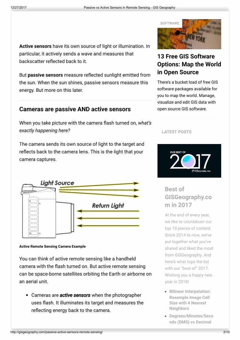
When you take picture with the camera �ash turned on, what’sexactly happening here?
The camera sends its own source of light to the target andre�ects back to the camera lens. This is the light that yourcamera captures.
Active Remote Sensing Camera Example
You can think of active remote sensing like a handheldcamera with the �ash turned on. But active remote sensingcan be space-borne satellites orbiting the Earth or airborne onan aerial unit.
Cameras are active sensors when the photographeruses �ash. It illuminates its target and measures there�ecting energy back to the camera.
13 Free GIS SoftwareOptions: Map the Worldin Open SourceThere’s a bucket load of free GISsoftware packages available foryou to map the world. Manage,visualize and edit GIS data withopen source GIS software.
SOFTWARE
LATEST POSTS
Best ofGISGeography.com in 2017At the end of every year,we like to countdown ourtop 10 pieces of content.Since 2014 to now, we’veput together what you’veshared and liked the mostfrom GISGeography. Andhere’s what tops the listwith our “best of” 2017.Wishing you a happy newyear in 2018!
Bilinear Interpolation:Resample Image CellSize with 4 NearestNeighbors
Degrees/Minutes/Seconds (DMS) vs Decimal
12/27/2017 Passive vs Active Sensors in Remote Sensing - GIS Geography
http://gisgeography.com/passive-active-sensors-remote-sensing/ 3/10
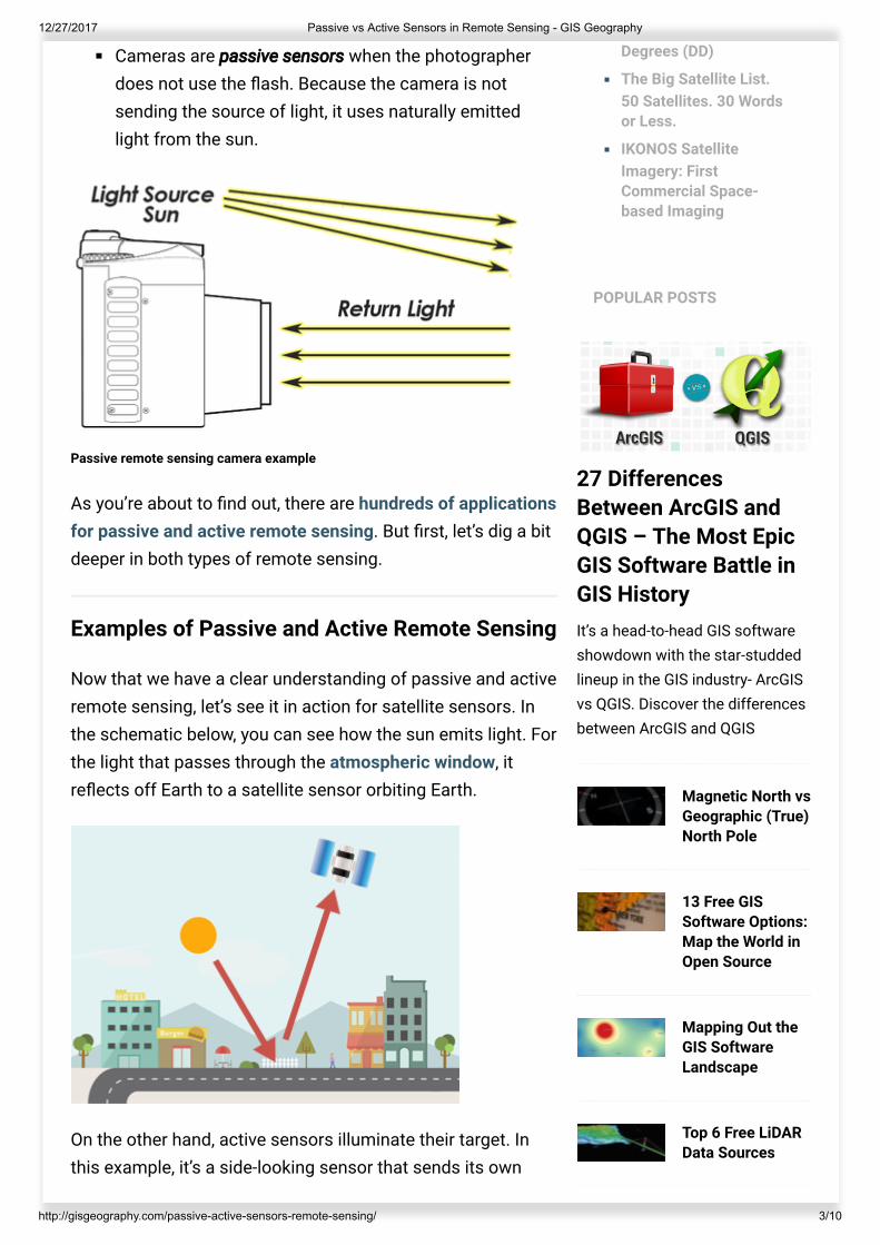
Cameras are passive sensors when the photographerdoes not use the �ash. Because the camera is notsending the source of light, it uses naturally emittedlight from the sun.
Passive remote sensing camera example
As you’re about to �nd out, there are hundreds of applicationsfor passive and active remote sensing. But �rst, let’s dig a bitdeeper in both types of remote sensing.
Examples of Passive and Active Remote Sensing
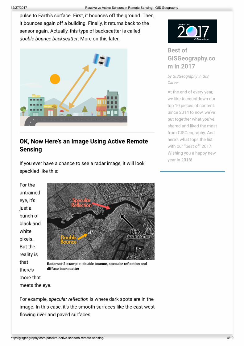
Now that we have a clear understanding of passive and activeremote sensing, let’s see it in action for satellite sensors. Inthe schematic below, you can see how the sun emits light. Forthe light that passes through the atmospheric window, itre�ects off Earth to a satellite sensor orbiting Earth.
On the other hand, active sensors illuminate their target. Inthis example, it’s a side-looking sensor that sends its own
27 DifferencesBetween ArcGIS andQGIS – The Most EpicGIS Software Battle inGIS HistoryIt’s a head-to-head GIS softwareshowdown with the star-studdedlineup in the GIS industry- ArcGISvs QGIS. Discover the differencesbetween ArcGIS and QGIS
Magnetic North vsGeographic (True)North Pole
13 Free GISSoftware Options:Map the World inOpen Source
Mapping Out theGIS SoftwareLandscape
Top 6 Free LiDARData Sources
Degrees (DD)
The Big Satellite List.50 Satellites. 30 Wordsor Less.
IKONOS SatelliteImagery: FirstCommercial Space-based Imaging
POPULAR POSTS
12/27/2017 Passive vs Active Sensors in Remote Sensing - GIS Geography
http://gisgeography.com/passive-active-sensors-remote-sensing/ 4/10
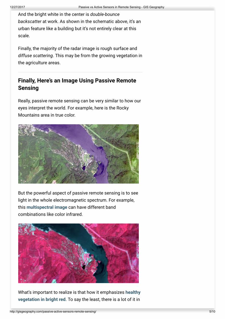
Radarsat-2 example: double bounce, specular re�ection anddiffuse backscatter
pulse to Earth’s surface. First, it bounces off the ground. Then,it bounces again off a building. Finally, it returns back to thesensor again. Actually, this type of backscatter is calleddouble bounce backscatter. More on this later.
OK, Now Here’s an Image Using Active RemoteSensing
If you ever have a chance to see a radar image, it will lookspeckled like this:
For theuntrainedeye, it’sjust abunch ofblack andwhitepixels.But thereality isthatthere’smore thatmeets the eye.
For example, specular re�ection is where dark spots are in theimage. In this case, it’s the smooth surfaces like the east-west�owing river and paved surfaces.
Best ofGISGeography.com in 2017by GISGeography in GISCareer
At the end of every year,we like to countdown ourtop 10 pieces of content.Since 2014 to now, we’veput together what you’veshared and liked the mostfrom GISGeography. Andhere’s what tops the listwith our “best of” 2017.Wishing you a happy newyear in 2018!
12/27/2017 Passive vs Active Sensors in Remote Sensing - GIS Geography
http://gisgeography.com/passive-active-sensors-remote-sensing/ 5/10
And the bright white in the center is double-bouncebackscatter at work. As shown in the schematic above, it’s anurban feature like a building but it’s not entirely clear at thisscale.
Finally, the majority of the radar image is rough surface anddiffuse scattering. This may be from the growing vegetation inthe agriculture areas.
Finally, Here’s an Image Using Passive RemoteSensing
Really, passive remote sensing can be very similar to how oureyes interpret the world. For example, here is the RockyMountains area in true color.
But the powerful aspect of passive remote sensing is to seelight in the whole electromagnetic spectrum. For example,this multispectral image can have different bandcombinations like color infrared.
What’s important to realize is that how it emphasizes healthyvegetation in bright red. To say the least, there is a lot of it in
12/27/2017 Passive vs Active Sensors in Remote Sensing - GIS Geography
http://gisgeography.com/passive-active-sensors-remote-sensing/ 6/10
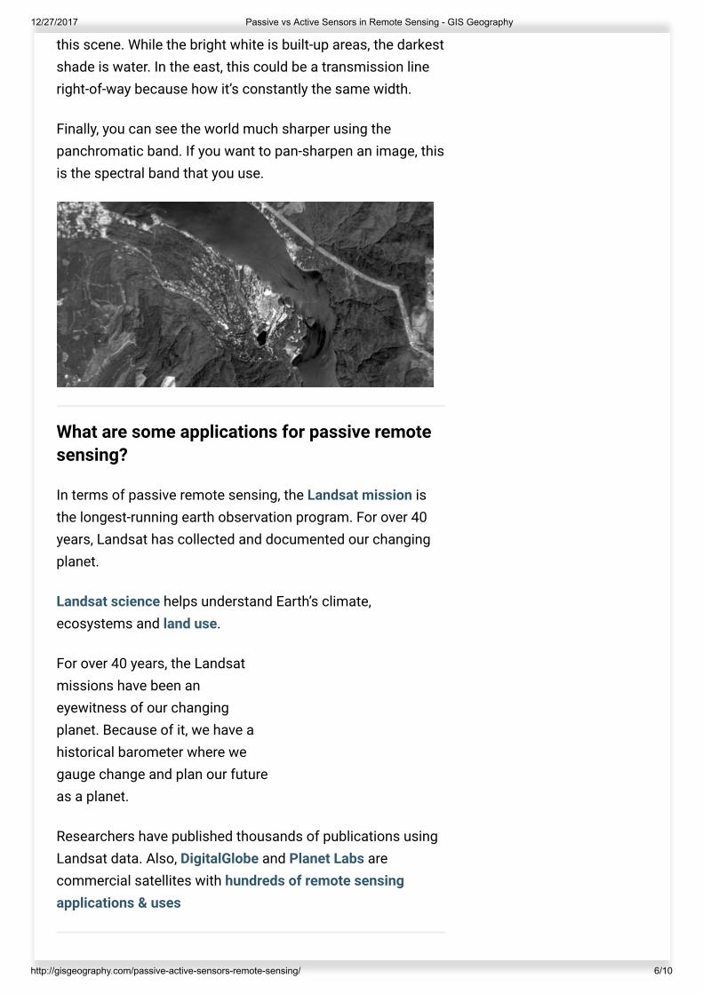
this scene. While the bright white is built-up areas, the darkestshade is water. In the east, this could be a transmission lineright-of-way because how it’s constantly the same width.
Finally, you can see the world much sharper using thepanchromatic band. If you want to pan-sharpen an image, thisis the spectral band that you use.
What are some applications for passive remotesensing?
In terms of passive remote sensing, the Landsat mission isthe longest-running earth observation program. For over 40years, Landsat has collected and documented our changingplanet.
Landsat science helps understand Earth’s climate,ecosystems and land use.
For over 40 years, the Landsatmissions have been aneyewitness of our changingplanet. Because of it, we have ahistorical barometer where wegauge change and plan our futureas a planet.
Researchers have published thousands of publications usingLandsat data. Also, DigitalGlobe and Planet Labs arecommercial satellites with hundreds of remote sensingapplications & uses