Embed Size (px)
Citation preview

10 Years Down the Road:The State Road 7/ U.S. 441 Collaborative
Prepared by the South Florida Regional Planning Council2011


TABLE OF CONTENTS
Introduction ............................................................................................................................................................................................1
State Road 7 Corridor Segment Map .............................................................................................................................................3
Florida Department of Transportation .........................................................................................................................................5
Broward County .....................................................................................................................................................................................6
Broward Metropolitan Planning Organization ...........................................................................................................................7
Segment 1City of Coconut Creek ..........................................................................................................................................................................9City of Coral Springs .............................................................................................................................................................................9City of Parkland ................................................................................................................................................................................... 10
Segment 2City of Margate .................................................................................................................................................................................... 10
Segment 3City of North Lauderdale ................................................................................................................................................................. 12City of Tamarac .................................................................................................................................................................................... 12
Segment 4City of Lauderdale Lakes .................................................................................................................................................................. 13City of Lauderhill ................................................................................................................................................................................ 17
Segment 5City of Plantation ................................................................................................................................................................................ 20City of Fort Lauderdale ..................................................................................................................................................................... 23
Segment 6Town of Davie ...................................................................................................................................................................................... 24City of Hollywood ............................................................................................................................................................................... 26
Segment 7Town of Miramar ................................................................................................................................................................................. 29City of West Park ................................................................................................................................................................................. 29
Segment 8City of Miami Gardens ...................................................................................................................................................................... 30City of North Miami ........................................................................................................................................................................... 31
South
Florida R
egional Planning
Council


South
Florida R
egional Planning
Council
10 Years Down the Road
At its inception in 2001, the Collaborative was formed as a regional partnership to address the economic and aesthetic conditions of Broward County’s deteriorating State Road 7/U.S. 441 Corridor and its impact on abutting cities. The original group and their representatives included: City of Lauderhill Commissioner Leanna “Lee” Mirsky; Plantation Mayor Rae Carol Armstrong; Miramar Mayor Lori Mosely; Lauderdale Lakes Commissioner Hazzelle Rogers; and Hollywood Mayor Giulianti. It wasn’t long before they invited the remaining 11 area jurisdictions to join the effort.
The communities conducted regular monthly meetings, rotating locations among the jurisdictions, and shared the common goal of improving the Corridor. The group asked the South Florida Regional Planning Council for assistance, and the Council responded with funding from the Florida Department of Community Affairs and the Florida Department of Community Affairs. The group was then able to organize and establish the Partnership Agreement, Mission Statement, Organizational Structure, and long-term plan. Thus, the State Road 7/U.S. 441 Collaborative was official.
The Partnership Agreement created a Steering Committee comprised of one representative from each of the Corridor jurisdictions, and extended ex-officio membership to the Broward County Metropolitan Planning Organization, Broward County School Board, Broward County Planning Council, Florida Department of Transportation, South Florida Water Management District, Florida Department of Community Affairs, and South Florida Regional Planning Council. A portion of State Road 7/U.S. 441 also includes the Seminole Nation.
The Collaborative targeted various funding opportunities to develop the State Road 7 Strategic Master Plan. In 2002, the Regional Plan Association and the Lincoln Land Institute studied the Corridor and analyzed its redevelopment potential. (The Sustainable Corridor Study is available at www.sfrpc.com/sr7.htm.)
The Collaborative’s work was supported by local in-kind services and funding from the Department of Community Affairs, Florida Department of Transportation, Broward County Metropolitan Planning Organization, South Florida Regional Resource Center, John D. and Catherine T. MacArthur Foundation,
“We should have a local concept. We should cherish a love and pride in local conditions and local achievements. In a word, we should frame a concept, an ideal of what we wish the city to be, and then we should make it one of the controlling purposes in the development of the city plan.”
John Nolen: From his book, “Replanning Existing Cities” 1912
1

and the Federal Highway Administration. Additionally, the SFRPC leveraged technical assistance services from the Regional Plan Association, Lincoln Land Institute, the Urban Land Institute, and the Department of Housing and Urban Development.
In 2003, the Collaborative received a $1.9 million grant from the Federal Highway Administration to fund a Corridor Strategic Master Plan that included tasks to promote smart growth principles, planning studies, and implementation strategies for the future. The first task was a market assessment for the entire Corridor that was conducted in partnership with the Urban Land Institute (ULI), and included nearly 54,000 new Corridor residential units by 2030, in addition to a mix of retail, office, hotel, and flex space. Initial projections indicated potential new Corridor development was over $17 billion.
The development of each Corridor community’s vision was the next task. The Corridor was divided into 9 distinct planning segments that facilitated seven-day planning charrettes, starting in 2003 and concluding in 2005. Each charrette had a citizen steering committee that engaged local citizens and business sectors in the development and ownership of the plan. The steering committee members were the plan’s “champions” and made certain that the plan was followed. The Design Studio of the Treasure Coast Regional Planning Council, a recognized leader in smart growth through community design and active community participation, conducted each of the charrettes.
The charrettes identified implementation issues that included the need for new land use category. The Collaborative worked with the Broward County Planning Council to create the Transit Oriented Corridor, which was adopted in 2005 to accommodate “The People’s Plan.” It allowed each corridor community to amend its Future Land Use Plan to conform to its vision. The County also waived the $7,200 amendment application fees, resulting in a combined savings of $100,800.
The Collaborative process fostered a new-found trust between local jurisdictions and agencies that helped resolve Corridor-wide issues associated with right-of-way reservations, roadway configuration, and regional transit. The Collaborative was able to identify inconsistencies by working with regional transportation agencies to ensure that future transportation needs and community visions were accommodated in a thoughtful and beneficial manner. The results were so impressive that the Collaborative was invited to serve on technical review committees of the State Road 7 Rapid Bus Project, the State Road 7 Bus Rapid Transit Project, and the Broward County Transit 2030 Master Plan, and asked to provide for the development of the Central Broward East-West Transit Study.
The Collaborative, a multi-jurisdictional and agency partnership, is the representative for the longest and most inclusive corridor in the country, with 32 miles of roadway and 16 municipal jurisdictions. It has attracted state and national attention for its comprehensive and innovative planning approaches and is truly a model for regional cooperation that can be replicated on many levels. The Collaborative’s legacy is realistic economic and aesthetic improvements that play a crucial role in South Florida’s sustainable growth.
Experience 10 years of collaborative success by taking an enjoyable ride down the improved State Road 7/U.S. 441 Corridor!
2

3

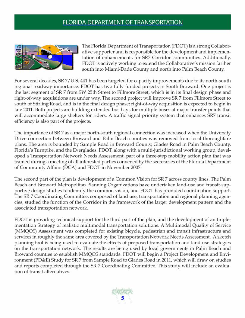
FLORIDA DEPARTMENT OF TRANSPORTATION
The Florida Department of Transportation (FDOT) is a strong Collabor-ative supporter and is responsible for the development and implemen-tation of enhancements for SR7 Corridor communities. Additionally, FDOT is actively working to extend the Collaborative’s mission farther south into Miami-Dade County and north into Palm Beach County.
For several decades, SR 7/U.S. 441 has been targeted for capacity improvements due to its north-south regional roadway importance. FDOT has two fully funded projects in South Broward. One project is the last segment of SR 7 from SW 25th Street to Fillmore Street, which is in its final design phase and right-of-way acquisitions are under way. The second project will improve SR 7 from Fillmore Street to south of Stirling Road, and is in the final design phase; right-of-way acquisition is expected to begin in late 2011. Both projects are building extended bus bays for multiple buses at major transfer points that will accommodate large shelters for riders. A traffic signal priority system that enhances SR7 transit efficiency is also part of the projects.
The importance of SR 7 as a major north-south regional connection was increased when the University Drive connection between Broward and Palm Beach counties was removed from local thoroughfare plans. The area is bounded by Sample Road in Broward County, Glades Road in Palm Beach County, Florida’s Turnpike, and the Everglades. FDOT, along with a multi-jurisdictional working group, devel-oped a Transportation Network Needs Assessment, part of a three-step mobility action plan that was framed during a meeting of all interested parties convened by the secretaries of the Florida Department of Community Affairs (DCA) and FDOT in November 2007.
The second part of the plan is development of a Common Vision for SR 7 across county lines. The Palm Beach and Broward Metropolitan Planning Organizations have undertaken land-use and transit-sup-portive design studies to identify the common vision, and FDOT has provided coordination support. The SR 7 Coordinating Committee, composed of land use, transportation and regional planning agen-cies, studied the function of the Corridor in the framework of the larger development pattern and the associated transportation network.
FDOT is providing technical support for the third part of the plan, and the development of an Imple-mentation Strategy of realistic multimodal transportation solutions. A Multimodal Quality of Service (MMQOS) Assessment was completed for existing bicycle, pedestrian and transit infrastructure and services in roughly the same area covered by the Transportation Network Needs Assessment. A sketch planning tool is being used to evaluate the effects of proposed transportation and land use strategies on the transportation network. The results are being used by local governments in Palm Beach and Broward counties to establish MMQOS standards. FDOT will begin a Project Development and Envi-ronment (PD&E) Study for SR 7 from Sample Road to Glades Road in 2011, which will draw on studies and reports completed through the SR 7 Coordinating Committee. This study will include an evalua-tion of transit alternatives.
5

BROWARD COUNTY
Broward County has been an integral partner in the SR 7/U.S. 441 Collaborative since the group organized in 2002. Although only small segments of the Corridor lie within the unincorporated area of Broward County (a total of 3.5 acres), the Collaborative is regional and important land use and transportation issues require the County’s support and participation.
Broward County’s 2008 Transit and Housing Oriented Redevelopment (THOR) initiative relied on information gathered during a Corridor Charrette to plan and direct redevelopment along the transportation corridor, which runs a quarter mile east and west of the Corridor between Peters Road/ Davie Boulevard and I-595, and has the capacity and infrastructure to accommodate mixed-use development. THOR’s goal was to protect existing residential neighborhoods while addressing livability issues such as walkability and affordable housing. Input was gathered through a series of public.
A multi-disciplined team of design professionals reviewed the Corridor’s issues and opportunities and created a final report that included redevelopment recommendations naming areas with potential, identifying incentives for economic development and models for phased redevelopment. Other recommendations were a Transit Oriented Corridor (TOC) land use plan amendment, new zoning districts, transit enhancements, design guidelines to promote pedestrian scale, and multi-modal redevelopment that responds to local cultures and the sub-tropical climate.
“State Road 7 is an evolving premium transit corridor. Through the years BCT and its partners lay important transit and beautification infrastructure investments that have attracted new riders to BCT service and provide the framework for future service enhancements along the corridor. During the past decade Broward County Transit has provided enhanced services (headway improvements and span of service) on Route 18 and limited stop route (441 Breeze) to meet the increased demand. To date this corridor carries the highest ridership within the BCT system. Future plans have high frequency Rapid bus service (BRT) along this corridor and the remodeling of the Lauderhill City Center transit terminal among others.”
6
State Road 7 Corridor Study Area

BROWARD MPO
Since 2002, the Broward Metropolitan Planning Organization (MPO) has been a key participant and contributor, as well as a founding member, to the Collaborative. The MPO helped prepare a $1 million Transportation and Community System Preservation (TCSP) grant, and through its chairman, Mayor Richard Kaplan, requested a federal earmark for up to $1.5 million for Corridor master planning and redevelopment efforts.
Along with Corridor master planning, the MPO provides funding for the betterment of the area. In the past year alone, the MPO allocated $685,000 planning and engineering funds toward the design/build of transit facilities along the Corridor, as well as $2.8 million for the design/build phase (construction). Broward County Transit and the Florida Department of Transportation (FDOT) partnered to make transit bus shelters and amenities a reality. The MPO has also provided $6.145 million for landscaping and other Corridor enhancements, plus $700,000 for pedestrian-safety improvements.
The recently adopted 2035 Long Range Transportation Plan (LRTP) outlines a new direction for sustainable transportation and community participation, while allowing the Collaborative to continue its partnership with the MPO to advance transportation improvements, address land use amendments, propose rezoning and design guidelines, support business retention, and attain affordable housing. The recommended changes encourage a balanced and forward thinking system of investments for mass transit, bicycle, pedestrian, and smart growth policies, according to its mission to “promote the safe, secure, and efficient movement of people and goods by providing balanced transportation choices that support superior mobility through improvements in all modes with a focus on mass transit and transit-supportive land use in key corridors and mobility hubs.”
The Collaborative passed a resolution fully supporting the plan. For more information about Broward’s 2035 LRTP, please visit our website at http://www.broward2035lrtp.com/projectdocuments.html.
7

8
Coconut Creek/Coral Springs/Parkland Master Plan
1. Parkland Entrance Feature2. Hillsboro Pineland Natural Area Entrance and Nature Center3. Wal-Mart Reconfigured4. Linear Park5. Neighborhood Center6. Target Reconfigured7. Seminole Nation Casino

CITY OF COCONUT CREEK
The City of Coconut Creek’s estimated population is 47,804 and the City is approximately 12 square miles, with 3.8 miles fronting SR 7/U.S. 441 from Sample Road north to the Broward/Palm Beach County line. Since the Corridor Charrette was completed in December 2005, the City has incorporated several redevelopment initiatives and continues to plan for future economic development and
sustainable growth, including land use changes and rezoning.
A Regional Activity Center (RAC) land use was adopted in 2006 for 2,700 residential units, 1.2 million square feet of commercial space and 800,000 square feet of office space within the City’s Main Street at Coconut Creek development. In addition, almost 350,000 square feet of commercial space was completed in 2008 - 2009.
Coconut Creek received funding for median improvements and installed transit shelters along the Corridor that revitalized the roadway and enhanced pedestrian safety. The City supports the Collaborative and continues to implement the Corridor Master Plan with an Open Space and Public Amenity Study for the Main Street development and plans for a Gateway Transit Hub at the Sample Road intersection. The Seminole Tribe’s Coconut Creek Casino is planning an expansion with proposed rezoning for the construction of a hotel, parking structures, retail shops and entertainment venues.
CITY OF CORAL SPRINGS
The City of Coral Springs has an estimated population of 127,198 and encompasses approximately 25 square miles, with 3.5 miles of frontage on the northern border of Broward County along SR 7/U.S. 441. The City has been involved with the planning for the transition of the Corridor from the more urbanized roadway profile to the south to the more rural roadway profile of limited access to residential areas and commercial clusters to the north.
9

10
CITY OF PARKLAND
The City of Parkland has an estimated population of 23,647 and encompasses approximately 12.8 square miles, with 1.9 miles of frontage on SR 7/U.S. 441. As Broward’s northernmost Collaborative Community, Parkland plays an important role as the Corridor transitions into a residential land use with commercial and retail nodes. A major development since the
City’s 2006 Charrette was the incorporation of new land into Broward County from Palm Beach County, including 684 acres into Parkland in 2009. Access to the proposed development is currently only from SR 7/U.S. 441, prompting the need for a series of mobility studies for the northern Broward and southwest Palm Beach Counties to address connectivity and plan for increased usage by future residents who will rely on the Corridor. To date, several studies have been completed, including a “Common Vision for SR 7,”which analyzes Corridor land uses and explores the potential for increased transit in the area.
CITY OF MARGATE
The City of Margate has an estimated population of 56,000 and encompasses approximately 9 square miles, with 7.8 miles of frontage on SR 7/U.S. 441. The Corridor Charrette was completed in October 2003, and since that time, the Margate Community Redevelopment Agency (CRA) and City staff have implemented its recommendations. A Transit Oriented Corridor (TOC) land use was adopted for the entire Corridor area in October 2007, and a year later the City adopted Corridor form-based land development regulations.
The entire Corridor area is within the City’s CRA district and benefits from Tax Increment Funds (TIF), as well as State and Federal grants. The Margate Corridor was landscaped between 2000-2004, and the State of Florida repaved SR 7 in Margate as part of a resurfacing, restoration and rehabilitation project in June 2010, which includes additional landscaping in the amount of $1.066 million.
A new bus shelter was designed and constructed at Coconut Creek Parkway and SR 7 and six additional bus shelters are planned for construction this year.
Margate’s top priority is the transformation of the intersection of SR 7 and Margate Blvd. to a vibrant City Center. The Master Plan for the City Center and Market Study were refined and completed in 2008 with assistance from the South Florida and Treasure Coast Regional Planning Councils and Economic Research Associates. Margate also received a matching grant from the Economic Development Administration for a Small Business Development Program, which was completed in September of 2009.

11
North Lauderdale/Tamarac Master Plan
1. Proposed rapid transit stops2. New park and botanical/sculpture garden3. Imperial Estates redevelopment4. New school5. Village Park redevelopment6. Sunshine Plaza redevelopment7. SW 17th Street redevelopment8. Triangle infill redevelopment9. Kimberly Plaza10. Home Depot/Publix Plaza11. Champion Plaza

CITY OF NORTH LAUDERDALE
The City of North Lauderdale has an estimated population of 41,310 and encompasses approximately 3.9 square miles, with 2.8 miles of frontage on SR 7/U.S. 441. Since the 2007 Corridor Charrette, the City has worked with the area’s business community and residents to implement their goals. During the past three years, the City has added two housing developments, San Remo and Altis, along with a gas station, as part the redevelopment efforts along Corridor. The City remains committed to the efforts of redeveloping the SR 7 Corridor
TAMARAC
CITY OF TAMARAC
The City of Tamarac has an estimated population of 59,151 and encompasses approximately 12 square miles, with only 1 mile of frontage on SR 7/U.S. 441. Although the Corridor is not part of the City’s central business district, it has been the focus of the City’s Collaborative designees since the Collaborative was initiated. Tamarac benefited from the Trafficways Plan amendment by Lauderdale Lakes to the south that reduced the reserved right of way and increased usable frontage along the Corridor. In addition,
the City benefited from the Corridor-wide landscape audit and will be working with the Florida Department of Transportation on the installation of proposed landscape enhancements.
12

13
CITY OF LAUDERDALE LAKES
The City of Lauderdale Lakes has an estimated population of 32,000 and encompasses approximately 4.5 square miles, with 3.9 miles of frontage on SR 7/U.S. 441. In 2004, the City held its first visioning sessions that morphed into a week-long design Charrette for city officials, residents, business owners and planning professionals, which then led to months of research,
stakeholder interviews, and ultimately a “Citizens’ Master Plan” that set the goals and vision for the community’s future. Identified goals included: a mixed-use Town Center; new City identity, library, cultural center, housing, community pool and parks; roadway improvements, beautification, and the revitalization of business corridors. All new City projects are regulated to support the Citizens’ Master Plan, which was adopted by the City Commission and Community Redevelopment Agency (CRA) in 2005.
In 2005, City residents overwhelmingly approved the $15-million Great Lakes General Obligation Bond Program to fund public improvements that included: four new municipal parks, a new public swimming pool complex, and a Greenway/Blueway Trail on the C-13 Canal. Broward Metropolitan Planning Organization (MPO)/ Florida Department of Transportation (FDOT) funded 12 bus shelters that cost $60,000 each and committed to 10 additional shelters. The City, in conjunction with FDOT, has invested hundreds of thousands of dollars into Corridor improvements since adopting the Master Plan, which added sidewalks, street lights, landscaping and other hardscape improvements.
In 2005, construction began on Bella Vista, a 30-acre, mixed-use development with 541 dwelling units and 18,000 sq. ft. of retail space, a village green, gazebo, fountain, clubhouse and pool, with an estimated build-out value of $150 million. Between 2006 and 2007, the City added four new municipal parks, including the C-13 Canal Greenway Trail, a mile-long, multi-use trail that runs along the northern end of the South Florida Water Management District’s C-13 Canal between the Corridor and NW 31st Ave. in the City. While the Trail is an ideal place for community events, relaxation, reflection and rejuvenation, it also provides a safe route to school and recreation facilities, and a pedestrian and bicyclist connection
to commercial areas on a dedicated, safe, non-motorized pathway.
The City was required to make several land use and zoning changes following the adoption of the CRA Citizen’s Master Plan. In 2006, the City amended its Comprehensive Plan to include the mixed-use Local Activity Center (LAC) land use designation. The amended map changed 144 acres from
Bella Vista Groundbreaking
SR 7 Bus Shelter

14
commercial land use designation to LAC, and the amendment’s text stipulated a total of 3,000 dwelling units, 300 lodging rooms, 500,000 square feet of commercial, 5 acres recreation and open space and 5 acres community facility use within the LAC.
The City commissioned several additional redevelopment studies to implement its vision. Examples are the City’s 2007 Retail and Marketing Study that provided strategies for business retention and recruitment efforts; and the 2008 Streetscape Master Plan that designed and beautified specific City corridors and identified a landscape palette and theme.The City adopted two Broward County Trafficways Amendments that reduced the Corridor’s ultimate right-of-way. The first amendment completed in 2007 reduced the right-of-way from 200’ to 150’ of mainline, and 187’ of expanded intersections from NW 19th Street to Oakland Park Blvd. The second amendment was completed in 2008 and reduced the Corridor right-of-way from 200’ to 150’ of mainline, and 175’ of expanded intersections from Oakland Park Blvd. to Commercial Blvd. The 2009 CRA Plan update was also a direct outcome of Master Plan implementation, because the City needed a new plan since all public projects in the original 2005 Master Plan were completed.
In response to local demands in community visioning/public participation process for efficient and modern transportation alternatives and the intensity of South Florida weather, the Lauderdale Lakes and the CRA completed the design and development of six new bus shelters at a cost of $60,000 each during 2007-2008. Additional grant funding from the MPO and FDOT has been committed for the development of up to 10 more shelters to be added in future years.
On January 26, 2010, the City Commission approved two Corridor-related resolutions. The first resolution supports two studies of light-rail and bus rapid transit technologies. The Central Broward East-West Transit Study and Draft Environmental Impact Statement suggested light-rail transit along the Corridor, bus rapid transit west of the Corridor, and the appropriate technology as determined for alignment east of the
Corridor. The second resolution supports the proposed Central Broward East-West Transit Study Alignment Option 9 along Oakland Park Boulevard to promote mobility, economic vitality and quality of life along the Corridor.
Following the 2006 adoption of the text and map amendment to the Comprehensive Plan, the City also adopted two new mixed-use zoning districts in the LAC. The first new zone is a Traditional Neighborhood–Planned Unit Development (TN-PUD) district, which provides land owner flexibility in devising standards to be considered by the City and must be specifically applied for by the land
owner and granted by the City. The second zone is the Town Center (TC), which provides concrete and inflexible standards for implementing traditional neighborhood design. In 2006, the City also adopted single architectural style for the City and accompanying design criteria.
Charrette Town Center Perspective
Library on the Green

15
Lauderdale Lakes Master Plan
16
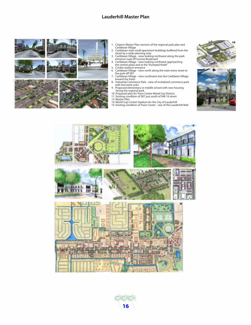
Lauderhill Master Plan
1. Citizens’ Master Plan verrsion of the regional park plan and Caribbean Village2. Caribbean-style small apartment buildings buffered from the street by a wide planning strip3. Caribbean Village - view looking northwest along the park entrance road off Sunrise Boulevard4. Caribbean Village - view looking northwest approaching the central plaza and at the ‘Stumped Hotel”5. Cricket stadium entrance6. Caribbean Village - view north along the main entry street to the park off SR7.7. Caribbean Village - view southwest into the Caribbean Village toward the hotel8. Industrial Commerce Park - view of revitalized commerce park with live/work units9. Proposed elementary or middle school with new housing facing the regional park.10. Proposed plan for Town Center Mixed Use District.11. Existing condition of SR7 just south of NW 16 street13. Master Plan14. World Cup Cricket Stadium for the City of Lauderhill15. Existing condition of Town Center - rear of the Lauderhill Mall

17
CITY OF LAUDERHILL
The City of Lauderhill has an estimated population of 64,000 and encompasses approximately 8.6 square miles, with 2.9 miles of frontage on SR 7/U.S. 441. The area’s Corridor Charrette was held from March 6, 2004 through March 12, 2004. The City Commission adopted Resolution No. 05R-09-326 on September 12th, 2005, thereby formally adopting the SR 7/U.S. 441 Citizen’s Master Plan or final Charrette document.
Improvements made possible by City General Obligation Bonds in the amount of $4.3 million for Corridor roadway improvements included: $675,385 for intersection improvements at NW 16th Street, NW 19th Street, NW 21st Street, and NW 21st Street/ SR 7/U.S. 441; $1,650,000 for traffic signals at NW 11th Place (Avenue of the Arts)/ SR 7/U.S. 441 (entrance to Central Broward Regional Park); $600,000 for landscaping improvements.
Since 2000, the Florida Department of Transportation (FDOT), District 4, has constructed right-of-way improvements along the Corridor from NW 11th Place to NW 28th Street. Lauderhill has also supplemented the FDOT Corridor improvements through a series of intersection improvements with significant public and private development and redevelopment Corridor investments.
Additional studies include:
Expendable Income Market Comparison Study - The Planning and Zoning Department (PZD) conducted a 1-, 3- and 5-mile radius market comparison of the University Drive/Commercial
Boulevard intersection and the SR 7 /Sunrise Boulevard intersection based on expendable income and not gross income. Although the former market area was assumed to have substantially greater expendable income than the latter, the PZD Study determined that the difference was not substantial. The study also served as the basis for the City’s acquisition of property at the SR 7/Sunrise Boulevard intersection, the former K-mart Plaza and former McArthur Dairy site. Other studies are:
Corridor Right-of-Way Reduction from Sunrise Boulevard to NW 19th StreetState Road 7/U.S. 441 Slum and Blight Study (a/k/a CRA findings of fact)Corridor Right-of-Way Reduction from NW 19th Street to Oakland Park Boulevard Market Study Citywide Master Plan (2006)Street Improvement Project (2006)
21st Street - Public Open SpaceCharrette Image
Lauderhill Charrette Image

The City of Lauderhill has not amended the Citizen’s Master Plan since its adoption.
Transit enhancements include:
• Five City of Lauderhill community shuttle routes with terminus at Lauderhill Mall and coordinated shuttle routes from Plantation and Lauderdale Lakes;
• Four signature bus shelters along SR 7/U.S. 441 with next bus real time data;
• A DRI the for Lauderhill City Center, which proposes the relocation, expansion and enhancement of the existing public transit station and its redevelopment as a gateway transit hub; and
• Acquiring a 32’ wide landscape easement along the west side of SR 7 at the Lauderhill Mall for placement of a signature public transit shelter and amenities
• Since 2000, the City Commission has adopted Comprehensive Plan regulation amendments or text changes and Land Development Regulations amendments. The City Commission has acted to stimulate Corridor redevelopment with land acquisition and assembly, land disposition, and other activities.
18
Lauderhill Bus Station
Industrial Park South

19
Plantation Master Plan
1. Redevelopment/intensification of northern car dealerships2. Continued extension of slip street and redevelopment along SR73. Infill redevelopment around Plantation General Hospital4. Mixed-use neightborhood-scaled redevelopment5. Mixed-use transit-oriented development at the four corners of SR7 and Broward Boulevard6. Possible location of transit station for future east-west rail connector7. Continued extension of slip street along SR78. New mixed-use redevelopment with townhouse buffere to neighborhood along SR7.9. Existing slip street along SR7.10. Propsed Peters Road/Davie Boulevard extension traffic circle11. Peters Road redevelopment area12. Historic water treatment plan13. Improved park and residential development in Broadview Park neighborhood.14. Redevelopment/intensification of southern car dealerships15. New civic building in Broadview Park16. New public park.17. New neighborhood scaled redevelopment18. New ‘gateway’ redevelopment along SR7 at I-595 Interchange (Town of Davie jurisdiction)

CITY OF PLANTATION
The City of Plantation has an estimated population of 84,725 and encompasses approximately 22.8 square miles, with 4.5 miles of frontage on SR 7/U.S. 441. The City’s redevelopment of the Corridor has been funded primarily with City bonds issued in 2002 and 2003 totaling $4.6 million, and a bank note for $1.3 million issued in 2005. The funds were used for capital infrastructure along the Corridor and a Catalytic Investment Grant program. Additionally, an Economic Incentive Grant program was funded by City general funds.
The Catalytic Investment Grant and Economic Incentives programs were competitive grant processes opened to all interested CRA businesses. The purpose was to leverage funds from property and business owners to redevelop existing buildings/sites or develop new commercial projects. Both grant programs awarded just over $5.5 million to property and business owners, leveraging over $50 million over a seven year period.
CDBG federal funds in the amount of $574,000 financed additional capital infrastructure, such as street-end enhancements and landscaping along SR 7 and Sunrise Blvd., and enhancements at the Sunrise Blvd./SR 7 retention pond.
In 2006, the City obtained a Bus Shelter Grant for $80,000 from the South Florida Regional Planning Council to construct four bus shelters, and again in 2009, the City was awarded $8,000 in matching funds (50/50) from FDOT to build one additional bus shelter.
The City will construct the Park East neighborhood Multi-Use Recreational Trail (MURT) that starts at the NW corner of Sunrise Blvd. and SR 7. MURT will run west along the south side of the South Florida Water Management District C-12 canal, and will connect the Trail to the existing Park East Trail at NW 9th Court/NW 9th Drive west of SR 7. The project is funded through a 2005 federal earmark grant for $500,000 and will be administered through the Local Agency Participation program (LAP), administered by FDOT District IV. The City’s federal grant match will be in-kind services of design and administration. The MURT section will provide direct access to SR 7 for bikers and pedestrians, and it was recently completed.
Construction of the Old Peters Road Sewer Main was completed in June 2010, and now provides sanitary sewer access to all properties along the north side of Old Peters Road within the City limits, eliminated septic tank use, and will enhance the future of potential real estate development. To date, the City has approved two office/commercial projects that are expected to break ground in the near future. The project’s total investment was $618,604, $333,155 from federal CBDG funds and $285,449 from the CRA.
20
Plantation established a special purpose zoning district (SPI-2) in 2004 that includes six zoning sub-districts comprised of an auto mall, four corners, healthcare, hybrid commercial, professional office,
and artisan commerce sub-districts. Prior to 2004, the redevelopment district was controlled by citywide zoning and land use designations applicable at the time. In September 2004, the City took an additional step and adopted a Local Activity Center (LAC) to spur redevelopment and economic activity, and create residential land use capacity. The LAC is 400 acres and allows 1,960 residential units in the Plantation Gateway, 749 of which are existing occupied units. The remaining 1,211 residential units are available for future development of mixed-use or single-use residential projects.
The LAC designation provides higher density for future long-term residential, mixed-use residential, commercial and office developments similar to Park Place and Grove East in other areas of the District, where people can live, work, play, and create a sufficient critical mass of potential transit riders. A bonus for businesses or residents located in the Gateway District is the ease of public transportation with several Broward County Transit lines moving people from north and south into the Plantation Gateway District, west into the center of Plantation, and east to downtown Fort Lauderdale.
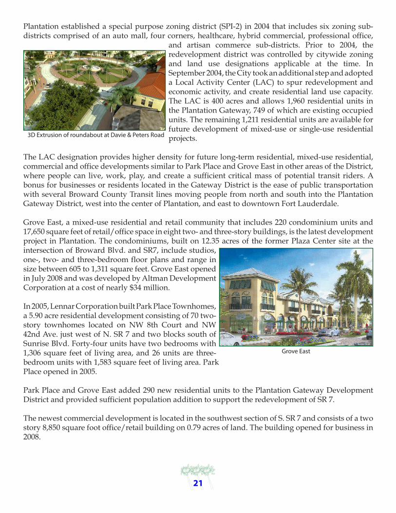
Grove East, a mixed-use residential and retail community that includes 220 condominium units and 17,650 square feet of retail/office space in eight two- and three-story buildings, is the latest development project in Plantation. The condominiums, built on 12.35 acres of the former Plaza Center site at the intersection of Broward Blvd. and SR7, include studios, one-, two- and three-bedroom floor plans and range in size between 605 to 1,311 square feet. Grove East opened in July 2008 and was developed by Altman Development Corporation at a cost of nearly $34 million.
In 2005, Lennar Corporation built Park Place Townhomes, a 5.90 acre residential development consisting of 70 two-story townhomes located on NW 8th Court and NW 42nd Ave. just west of N. SR 7 and two blocks south of Sunrise Blvd. Forty-four units have two bedrooms with 1,306 square feet of living area, and 26 units are three-bedroom units with 1,583 square feet of living area. Park Place opened in 2005.
Park Place and Grove East added 290 new residential units to the Plantation Gateway Development District and provided sufficient population addition to support the redevelopment of SR 7.
The newest commercial development is located in the southwest section of S. SR 7 and consists of a two story 8,850 square foot office/retail building on 0.79 acres of land. The building opened for business in 2008.
21
3D Extrusion of roundabout at Davie & Peters Road
Grove East

A second commercial development is located in the northwest section of N. SR 7, and is a two-story 7,614 square foot building on .30 acres of land. It has 5,000 square feet of retail space on the ground floor, and 2,500 square feet of office space on the second floor. The building opened for business in 2006.
NW 38th Way roadway beautification project from N. SR 7 to Broward Boulevard was completed in September 2007, and included new curbing, irrigation, and landscape material. The roadway’s dual jurisdiction of Plantation and Broward County led to a project partnership to complete the project, which began in early 2005 and was completed in June 2008.
Parallel shopping drive improvements in the northwestern section of SR 7 from the Florida Department of Children Services north to NW 5th Street were completed in June 2007, and included enhanced parking and access ramps in compliance with the American with Disabilities Act (ADA), better drainage, and pedestrian crosswalks with brick pavers, decorative street lighting poles, landscaping with Royal Palms and Cocoplum hedges, which is consistent with
the other landscape treatments throughout the Corridor.
All properties in the Plantation Gateway Development District must comply with the Gateway Enhancement Ordinance adopted on January 2001 and the Used Car Lot Ordinance adopted in June 2001, and must meet minimum development standards including adequate property maintenance, property improvements ranging from disabled parking spaces to sufficient customer parking, landscaping, signage and facade improvements. The standards are diligently overseen by the City’s Code Enforcement Unit, and compliance has been very successful.
Ordinances designed to match site plans and provide implementation through the zoning codes were adopted between 2002 and 2004. In April 2002, the City adopted the Plantation Tropical Design Guidelines, which addresses structure styles and colors.
An important component of District’s success is the City’s strategic implementation of a new zoning ordinance adopted in July 2003. It includes a special purpose zoning district (SPI-2) that clusters uses into six zoning sub-districts, including Auto Mall, Four Corners Commercial, Hybrid/Commercial, Healthcare, Professional Office, and Artesian Commerce. Within each zoning sub-district, a range of compatible land uses are permitted to allow for new business growth and development/redevelopment opportunities. On September 2004, the City adopted an updated citywide Sign Code and the Local Activity Center (LAC) designation for the Plantation Gateway District.
The SR 7 Citizen’s Master Plan is an integral part of the CRA Redevelopment Plan, which was updated in January 2006 to reflect the adoption of the latest City ordinances and anticipated impacts on future development and redevelopment of the Gateway District. Due to the current changing economic conditions and the impacts on area demographics, job creation, and development/redevelopment pace, the next CRA Plan update is expected to contemplate revisions to areas in the Citizen’s Master Plan.
22
Corner of Broward and SR7

23
CITY OF FORT LAUDERDALE
The City of Fort Lauderdale, a mature urban city, has an estimated population of 180,706 and encompasses approximately 35.5 square miles, with 1.9 miles of frontage on SR 7/U.S. 441. While the City is generally thought to be built-out, it has approximately 750 acres of vacant land scattered throughout the City on small parcels, including along SR 7/U.S. 441. The Florida Department of Transportation began construction of landscape enhancements along this portion of the Corridor in 2010.

24
TOWN OF DAVIE
The Town of Davie’s estimated population is 91,056 and encompasses approximately 35.5 square miles, with 3.5 miles of frontage on SR 7/U.S. 441. Since the Corridor Charrette was adopted in September 2005, the Town has followed the recommendations to adopt a Transit Oriented Corridor (TOC) land use designation for 925 acres adjacent to the roadway
and is creating form-based land development regulations for the TOC area. The redevelopment potential for the Town’s TOC area includes 6,428 residential units, 1.7 million square feet of office space, 3.6 million square feet of industrial/flex space, 600,000 square feet of commercial space and 750 hotel rooms. The Town is working closely with their Community Redevelopment Agency to develop a stormwater master plan for the TOC, along with a capital improvements program and an assessment of long term funding strategies.
Key TOC goals are:
Encourage transit supported development along the Corridor with an interconnected system of streets, sidewalks and other pathways to public transit stops and public parking areas that will enhance the economic development potential of the regional transit and transportation systems.
Establish the desired level of public facilities and services for the area, including water, wastewater, drainage, transit and affordable housing, while ensuring the fair-share costs are paid by new development and/or landowners, as appropriate.
In 2010, the Town coordinated with FDOT on the installation of landscape improvements and bike lane striping on SR7/U.S. 441 as part of the resurfacing project.
In May of 2011, using Transportation Enhancement Grant Funds, the Town completed improvements along Oakes Road to create a safe pedestrian route from an existing bus stop along SR7/U.S. 441.
Master Plan Buildout Area.

25
Hollywood/Seminole Nation Master Plan
Points of Interest
1. Seminole Nation Gaming District2. Intersection of SR7 and Sheridan Street - a transition intersection marking the entrance to Hollywood from the north and the beginning of the Seminole Nation.3. Linear parkway4. Taft Street and SR7.5. Hollywood Boulevard - The buildings along SR7 are the tallest and reduce their height heading east to match the context of the existing conditions in the surrounding neighborhoods.6. Melinium Mall redevelopment - the intersection of SR7 and Hollywood Boulevard could attract a signature office building as part of a mixed-use transti-oriented neighborhood.+ The plan should provide public streets and city park space.

26
CITY OF HOLLYWOOD
The City of Hollywood has an estimated population of 142,397 and encompasses approximately 30.8 square miles, with 7.3 miles of frontage on SR 7/U.S. 441. Since the completion of the Charrette in 2004, the City has been working to revitalize the only remaining Broward County portion of the Corridor with West Park and Miramar. The City is undertaking a road widening project for the underused portion of the Corridor from Pembroke Road to Fillmore Street, and plans to add one northbound lane and one southbound lane thereby increasing the number of lanes to six. Additional improvements include a landscaped median on SR 7/U.S.
441 along with strategically placed turning lanes, redeveloping the drainage ponds on the east and west side of the road to resemble parks, and adding bike lanes and additional landscaping along the Corridor. The property acquisition is approximately $110 million and construction cost is approximately $27 million. Widening from Fillmore to Stirling is fully funded for the first time, and is in the design phase. Construction is scheduled to begin in 2017, following the completion of the previous section.
FDOT will widen one small Corridor area at a time to minimize traffic disruption by avoiding construction during peak traffic hours and keeping at least four lanes open at all times. FDOT will place signs strategically along the Corridor directing traffic to business or shopping center entrances, and will keep businesses informed about work schedules.
The City held public forums in 2008 and 2009, and the City Commission heard a presentation in 2009, which led to an amendment of the existing Corridor land uses to Transit Oriented Corridor (TOC). Hollywood is proactively ensuring that proper TOC developments are implemented in cooperation with the countywide development of transit-supportive land uses. Mixed-use developments that incorporate residential, commercial, and office uses are allowed since the proposal of the following TOC Development Standards:
Boundaries: Pembroke Road to the south, South Fork New River Canal to the north, Florida’s Turnpike to the west and SW 58th Ave. to the east.
Total Acreage: Approximately 980 acres
Hollywood’s 2005 EAR recognized the City’s approaching build-out and identified new land use categories as a possible way to support population demands and facilitate redevelopment. A denser population equates to an increased demand for mass transit and close proximity to everyday services, so transit-based land use designations, like TOC, become very important by allowing mixed uses in City areas suited for the developments. The Corridor was rezoned in 2004 in anticipation of future demands and districts were tailor-made for the desired mixed-use and transit-focused characteristics. TOC land use category was added to the Comprehensive Plan/Future Land Use Map in 2005 to compliment the new zoning districts.

27
Hollywood and Broward County Transit anticipate the construction of 11 new Corridor transit shelters shortly. The City’s Department of Public Utilities is making water and sewer infrastructure improvements along the Corridor in two phases: Phase I is from Hollywood Blvd. north to Atlanta Street; Phase II is from Hollywood Blvd. south to Pembroke Road. Phase I design and permitting ran from January 2009 until July 2010. Due to ongoing negotiations with FDOT, the construction schedule has not been finalized as yet. Phase II design and permitting will begin in January 2012 and end in July 2013, and construction is scheduled to begin September 2014 and end June 2015. Phase I construction costs are $7.5 million, and $3 million for Phase II. Improvements include replacing the existing 6- and 8-inch water mains with new 8- or 12-inch water mains for improved water service, and the installation of a new gravity sewage collection system with two sewer lift stations along SR 7/U.S. 441. When the improvements are completed, area property owners will be required to connect their water to the lateral connection.
CITY OF CITY OF CITY OF CITY CITY
Land Use Designation
Commercial
Community Facilities
Industrial
O�ce
TOTAL
Hotel
Residential*
Acreage Square Feet Square Feet
408.78 53,419,370 15,000,000
34.7 4,534,596 1,000,000
38.27 5,001,124 1,000,000
7.99 1,044,133 2,000,000
63,999,223 19,000,000
EXISTING PROPOSED
0 rooms 2,500 rooms 2,400 single713 single family homes family homes2,183 townhomes 2,400 townhomes2,072 garden apts. 168 garden apts.
Existing Land Use Proposed TOC

28
Miramar/West Park
1. Mixed-use neighborhood2. Neighborhood center3. St. Stephens Church property4. New traffic signal5. Miramar warehouse district6. Utopia7. Hallandale Beach Boulevard street improvements8. Proposed West Park City Hall9. Sutton Road street improvements10. New neighborhood park and water storage/treatment location (possible school site)11. New traffic signal12. New residential street and dealership conversion13. Water collection, storage, and treatment14. New infill neighborhood

CITY OF MIRAMAR
The City of Miramar has an estimated population of 112,552 and encompasses approximately 19,969 acres, with 1.6 miles of frontage on SR 7/U.S. 441. The Corridor Charrette for the area was in February 2005, and the City has continually moved forward with redevelopment initiatives and roadway improvements since that time. Miramar has invested Community Development Block Grant (CDBG) funding along the Corridor, as well as local and state infrastructure investments to improve roadway conditions. The City has adopted a Transit Oriented Corridor
(TOC) Land Use for its portion of the roadway, and plans to construct new transit shelters with Federal Stimulus funds and create form-based land development regulations for the TOC area.
CITY OF WEST PARK
The City of West Park has an estimated population of 13,721 and encompasses approximately 2.2 square miles, with 1.6 miles of frontage on SR 7/U.S. 441. The Corridor’s Charrette for this segment was held between February 5, 2005 and February 11, 2005, prior to the City’s incorporation.
Right-of-way improvements include improvements by the Florida Department of Transportation (FDOT). In 2007, a 131,000-square foot commercial project was approved. Land use changes in 2006 include moving the entire Corridor to Transit
Oriented Corridor (TOC). A storm water analysis was completed by the City and a hotel market analysis was completed by a private hotel company.
Transit enhancements include providing bus shelters for the area.
Regulations for the area are rezoning to TOC with design guidelines. Phase II of the FDOT expansion should commence shortly.
29

30
CITY OF MIAMI GARDENS
The City of Miami Gardens has an estimated population of 109,730 and encompasses approximately 20 square miles, with 5.6 miles of frontage on SR 7/U.S. 441. The Corridor Charrette for this segment was held on August 23, 2006 and November 29, 2006. The City Council adopted the Resolution of Livable Communities Corridor Study on April 4, 2007, which was funded with a $75,000 grant from the Florida Department of Transportation (FDOT). Other public works’ projects are funded through local initiatives.
Roadway improvements include right-of-way and median landscaping. The City has committed $672,000 for an upcoming FDOT resurfacing project from NW 176th Street to 1200 feet south of NW 215th Street. The 2009-10 City Budget included $75,000 for landscaping design on SR 7/U.S. 441 from NW 183rd Street to NW 214th Street, while the estimated future project cost is $1.8 million. There is a possibility of a City-FDOT partnership for a grant that would include bus shelter installations by Transit Stimulus.
Resolutions include a $672,000 FDOT agreement for resurfacing, and a City Council adoption by resolution of Livable Communities Corridor Study on April 4, 2007. Mixed-use Planned Corridor District (PCD) regulations with landscape and streetscape standards are being drafted for the Corridor and other major corridors in the City as part of the Land Development Regulations rewrite.

31
CITY OF NORTH MIAMI
The City of North Miami has an estimated population of 60,000 and encompasses approximately 10 square miles, with 2.7 miles of frontage on SR 7/U.S. 441.
City right-of-way improvements were completed in 2009 with the Florida Department of Transportation’s (FDOT) major landscaping projects
along SR 7 in North Miami, from NW 107th Street to NW 137th Street. Additionally, ADA-compliant pedestrian ramps and decorative crosswalks were installed. The cost was approximately $2 million.
The City’s Comprehensive Plan designated the entire Corridor as Commercial Office with maximum heights up to 55 feet and 85% lot coverage. Policy 1.5.10 states that the City shall “encourage mixed-use developments along NW 7th Ave. that incorporate Transit Oriented Development (TOC) and green design standards that enhance both the aesthetic and economic vitality of the NW 7th Ave. Corridor and help to create a sense of place.”
The North Miami Community Redevelopment Agency (CRA) hired the Buxton Company to assist in identifying and matching potential retailers with the City’s consumer needs. The Corridor was one of the target areas analyzed and efforts are underway to attract specific businesses that best fit the opportunities from the surrounding area.
The City’s bus circulator, NOMI Express, serves the entire City with four fixed routes and an approximate ridership of 24,000 per month. The Green Route primarily serves the western part of the City and SR 7/U.S. 441, and is the busiest route on the system with about 7,500 riders. Efforts are underway to expand the system, enhancing links with Miami-Dade Transit Buses and providing bus shelters as well as bicycle parking at transit stops.
The City revised its zoning map in 2010, amending the entire zoning designation for properties fronting NW 7th Ave. from the B-1 to C-1 zoning district, which allows for heights up to 55 feet.
The North Miami’s Community Redevelopment Agency (CRA) has two Commercial Grant Programs to improve the façades of businesses along the City’s primary corridors. NW 7th Ave., the local name for SR 7/U.S. 441, is home to nine businesses that have received funding for improvements, including Arnold’s Royal Castle.

How The Master Plan Was Created: Public Process

How The Master Plan Was Created: Public Process


Revolving Loan FundThe South Florida Regional Planning Council Revolving Loan Fund is accepting applications from small to medium-sized businesses in Miami-Dade, Broward and Monroe Counties.
Miami-Dade County Renovation for Energy Efficient Loan Program REELMiami-Dade Energy Efficient Loan program is a revolving loan fund that provides funding to businesses in Miami-Dade County to institute improvements to their properties that result in a reduction in the electrical energy con-sumed by the business.
Developments of Regional Impact (DRIs)Pursuant to Chapter 380, Florida Statutes, Regional Planning Councils are charged with the coordination of multi-jurisdictional agency review of large-scale development projects, which may impact more than one County. These projects, known as Developments of Regional Impact (DRIs), are typically complex and require input from numer-ous reviewing agencies. The South Florida Regional Planning Council maintains a very active DRI program.
Southeast Florida Regional PartnershipThe Southeast Florida Regional Partnership is a growing partnership of public, private, non-profit, and civic stake-holders from the seven-county region of Monroe, Miami-Dade, Broward, Palm Beach, Martin, St. Lucie, and Indian River Counties. Regional Transportation and Land Use Planning The Council works with the region’s Metropolitan Planning Organizations, Florida Department of Transportation, other state and federal agencies, counties, cities and the private and nonprofit sectors to make sure that transpor-tation initiatives and improvements are supportive of the goals and policies articulated in the Strategic Regional Policy Plan. Florida Gold Coast Clean Cities CoalitionThe Florida Gold Coast Clean Cities Coalition is part of the U.S. Department of Energy’s National Clean Cities initia-tive. Clean Cities supports local decisions to reduce petroleum consumption in the transportation sector through the use of alternative fuels, advanced technology vehicles, and fuel economy measures. The Florida Gold Coast Clean Cities Coalition focuses on Broward, Martin, Miami-Dade, Monroe, and Palm Beach Counties to provide fuel-neutral policy direction in maximizing the use of vehicles operating on alternative fuels.
Local Emergency Planning CommitteeThe LEPC was established as required by the Emergency Planning and Community Right-To-Know Act (EPCRA), Title III of the Superfund Amendments and Reauthorization Act (SARA). Congress enacted EPCRA in an effort to help local communities protect public health and safety and the environment from chemical hazards. Eastward Ho! Brownfields PartnershipBecause actual or perceived environmental contamination in urban infill sites - along with the risks and costs as-sociated with addressing it - is a significant barrier to redevelopment in the Eastward Ho! corridor, the Partnership is targeting the remediation and sustainable reuse of contaminated and abandoned or underused sites as part of the larger Eastward Ho! effort.
Strategic Regional Policy Plan (SRPP)The Council, with input from other governmental entities and the private sector, prepares, adopts, and implements the goals and policies of the SRPP to balance the needs of the Region.
F
UN D
Rev
ol
ving Loan
SoutheastFlorida
RegionalPartnership
Indian RiverSt. LucieMartin
Palm BeachBroward
Miami-DadeMonroe
LEPC LocalEmergencyPlanningCommittee
For Hazardous Materials
DISTRICT
11
Council Programs

Prepared by theSouth Florida Regional Planning Council
3440 Hollywood Boulevard, Suite 140Hollywood, Florida 33021
954-985-4416, FAX 954-985-4417
www.sfrpc.com