Embed Size (px)
Citation preview
207
10. Plate Tectonics and False Alarms: 1960–1972
From the maw of the hole [at Koranga Crater] there belched an evil, sulphurous stink and a sinister column of smoke emerged. The ground was hot to touch for a radius of �fty feet, and after a couple of days began to open in deep, ominous �ssures …
James Sinclair (1981)
Advances in Science and Technology
Remarkable scienti�c and technological achievements in the 1960s had a major impact on understanding the nature of the volcanoes in Near Oceania. Satellites were being launched — the pioneering Russian Sputnik as early as 1957 — at the competitive Cold War frontier of space travel, so initiating development of both space-borne, earth-observing platforms and satellite communication systems and therefore opportunities for the future monitoring of volcanoes from space. Mainframe computers were being mainstreamed in scienti�c establishments generally. Telecommunications technology was advancing, too, including the development of ways to convert earthquake vibrations — which, up until then, had been transferred mechanically to the paper of seismograph drums — to electronic signals that could be transmitted by radio or telephone lines linked to centralised recording rooms. The United States in the early 1960s, also as part of its Cold War initiatives, established the World Wide Standard Seismograph Network (WWSSN) for the more accurate global detection of tectonic earthquakes and, more particularly, nuclear explosions.
G.A.M. ‘Tony’ Taylor in 1966 a�rmed that volcanology was still only a ‘Cinderella science [that advanced on] the ashes of catastrophe’,1 yet new approaches in volcanology were beginning to emerge. For example, there was growing research interest in studying the pyroclastic deposits of explosive eruptions and in deducing their mechanisms of formation. A speci�c example of such specialised research was that undertaken on the pyroclastic materials laid down in 1965 during a hydrovolcanic eruption in a lake at Taal volcano in the Philippines, where the volcanological phenomena of ‘base surge’ was �rst recognised and their distinctive features documented.2 Similarly, hydrovolcanic eruptions in 1963 at the summit of a largely submarine volcano, Surtsey, o�
1 Taylor (1966), p. 20.2 Moore (1967).
Fire Mountains of the Islands
208
the south coast of Iceland, were so distinctive and came to be recognised at so many other volcanoes, that the term surtseyan was coined for them. Surtseyan eruptions can produce base surges. Their de�ning characteristic, however, is the extreme fragmentation of the erupting magma, caused by water ‘�ashing’ to steam and shattering the magma, such as photographed at Long Island in 1953. The mix of white vapour clouds and dark sprays of exploding ash at times produces striking ‘cock’s tail’-like plumes.
Figure 80. The distinctive ‘cock’s tail’ pattern of a small surtseyan explosion from the near-surface vent of the submarine volcano Kavachi, Solomon Islands, can be seen in this photograph taken on 17 or 18 July 1977. Kavachi was in eruption several times during the 1970s.
Source: W.G. Muller, Barrier Reef Cruises, Yepoon.
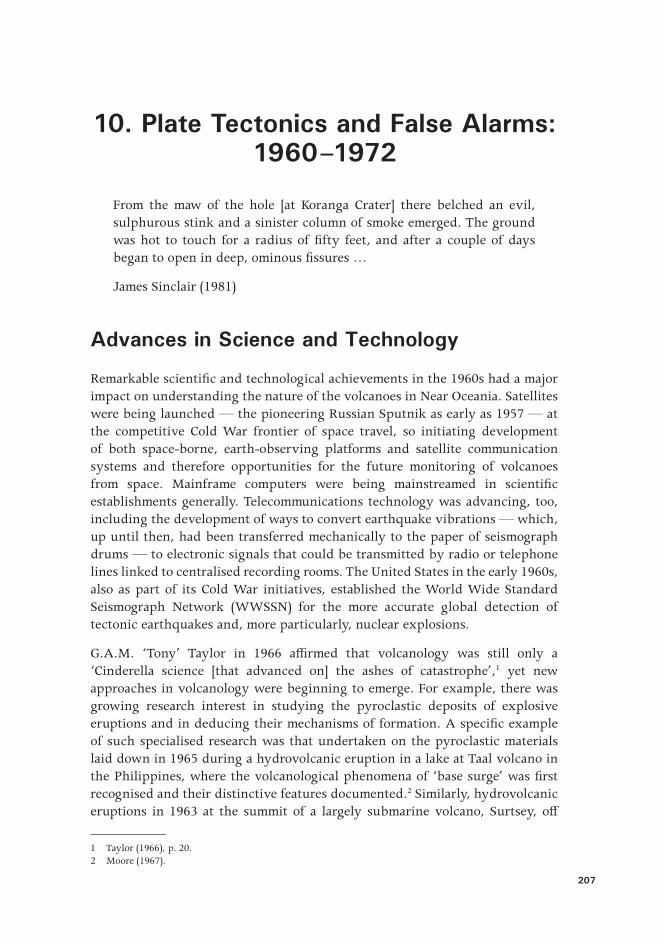
Much more important for the geosciences in general was the emergence of the revolutionary theory of plate tectonics in the late 1960s — the geoscienti�c equivalent of the theory of evolution in biology — meaning that attempts to understand volcanic disasters now had a rational geological framework. Earth was portrayed as a dynamic planet covered by a thin and broken ‘shell’ of tectonic pieces of di�erent sizes that move relative to one another. Converging tectonic plates create ‘subduction zones’, where one plate carrying water-rich rocks and sediments of the ocean �oor, disappears beneath a neighbouring plate along the convergent boundary between the two plates. Earthquakes track the descent of these great tectonic ‘slabs’ deep into the Earth as so-called Wadati-Benio� zones. Melting of deep rock takes place, and buoyant water-rich magma is returned to the surface in explosive volcanic eruptions, such as seen
10. Plate Tectonics and False Alarms: 1960–1972
209
commonly, and experienced catastrophically, in Near Oceania. Erupted magmas are characteristically andesite in compostion. Other tectonic plates separate, or diverge, from one another producing shallow earthquakes as well as new volcanic rocks on the ocean �oor in the process of ‘sea �oor spreading’. A good example of this divergent or ‘extensional’ type of plate boundary and related sea �oor volcanism is in the Woodlark Basin area of the Solomon Sea. My own volcanological research in the region began in 1969 when, with several others, I began collecting hundreds of volcanic-rock samples in an attempt to relate their chemical compositions to the di�erent plate-tectonic settings of the sampled volcanoes.
Figure 81. Most active volcanoes in Near Oceania can be related in one way or another to the geological process known as ‘subduction’. A tectonic plate shown here on the right plunges down to the left as a ‘slab’ in front of an overlying plate, forming a submarine trench on the ocean floor. Rock melting takes place above the subducted slab and the magmas so formed rise and erupt from volcanoes that form a line or ‘arc’ about 100–150 kilometres from the submarine trench.
Source: CartoGIS, The Australian National University.
These external achievements during the 1960s, and other new geoscienti�c ventures in Near Oceania itself, created a surge of volcanological understanding in the region into the 1970s. Systematic geoscienti�c mapping by both Bureau of Mineral Resources (BMR) and the Commonwealth Scienti�c and Industrial
Fire Mountains of the Islands
210
Research Organisation (CSIRO), throughout the Territory of Papua and New Guinea, yielded valuable volcanological information in those areas that included young volcanoes. Furthermore, the search for copper and gold by mineral-exploration companies focused attention on the roots of young volcanoes where ‘porphyry copper’ and gold mineralisation were thought to be present. A separate Port Moresby Geophysical Observatory (PMGO) began producing instrumental data in 1958. It was established by the BMR Geophysical Section in order to �ll a gap in the Australian region in the production of magnetic, ionospheric, gravity and tectonic-earthquake information. WWSSN stations were established in the early 1960s at the new Port Moresby Geophysical Observatory, as well as at RVO and in Honiara.
A network of volcanological observatories was established throughout the Territory of Papua and New Guinea in the 1960s. The observatory at Rabaul was named the ‘Central Volcanological Observatory’ and was sta�ed by professionally and technically trained people who also oversaw operation of the smaller and more remote ‘outstation’ observatories elsewhere in the territory. The headquarters observatory at Rabaul was upgraded under Taylor’s direction so that signals from recording stations in the harbour area could be transmitted to the RVO recording room by telephone and radio.3 Furthermore, major geophysical surveys were conducted in the late 1960s in order to determine Rabaul’s deep-crustal structure. A second type of observatory was built in 1963–1965, at considerable capital investment, on Manam Island and at Esa’ala in the D’Entrecasteaux Islands, again under the direction of Taylor. Both of these observatories had deep cellars constructed for the installation of modern seismometers and water-tube tiltmeters.
A third class of lesser observatories that did not have the luxury of quiet cellars was installed at Ulamona Roman Catholic Mission and Sawmill near Ulawun volcano, and near the then-operational Cape Gloucester Airstrip close to Langila volcano. All of these outstation observatories were sta�ed by part-time ‘volcano observers’ recruited locally from villages, the Administration, or religious missions. Headquarters sta� in Rabaul maintained radio contact with the observers and local Administration sta�, but instrumental records from the outstations had to be sent by mail to the central observatory at Rabaul for scienti�c assessment. Receiving reports of possible volcanic unrest at the other active or potentially volcanoes in the Territory and in British Solomon Islands Protectorate depended on local people, or the pilots of passing aircraft, informing the respective Administration o�ces and passing on the information to volcanological headquarters.
3 Newstead (1969).
10. Plate Tectonics and False Alarms: 1960–1972
211
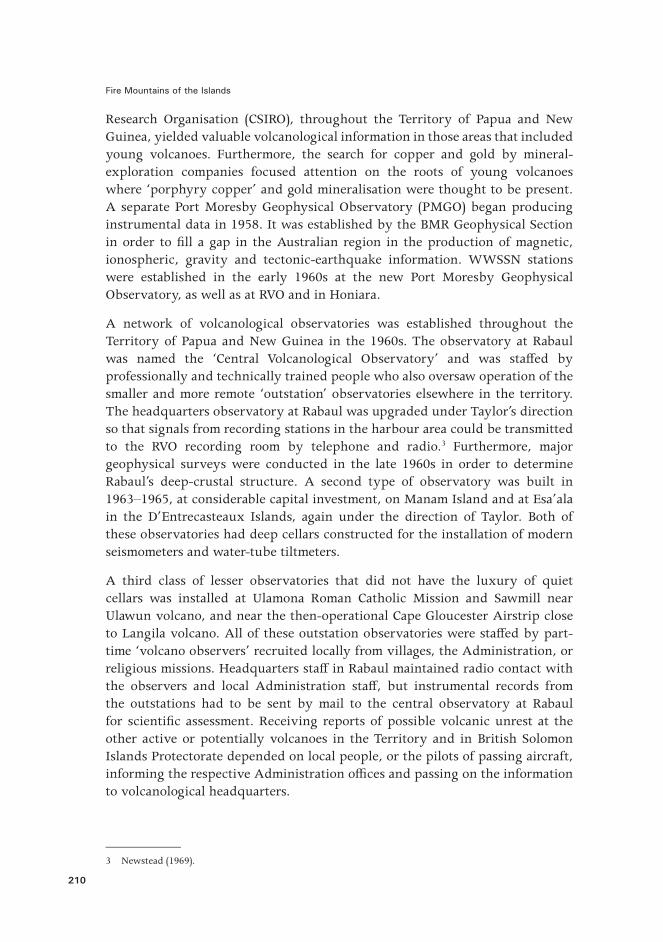
Figure 82. Leslie Topue and Ben Talai attend to monitoring equipment in the recording room at RVO in the late 1960s.
Source: RVO photographic collection.
Tony Taylor during the 1960s began taking on more supervisory roles for BMR in Port Moresby and in Canberra where he was raising a family. BMR geoscientists John H. Latter, Colin D. Branch, Gianni W. D’Addario, and W. David Palfreyman successively took over as head of the RVO into the 1970s, although Taylor and N.H. Fisher remained in control of the observatory’s strategic directions. A key responsibility of all RVO sta� — whoever was in charge — was maintaining e�ective communication links with Territory Administration sta�, as had happened in the 1950s, and especially with the District Commissioners of volcanically active districts and with Australian patrol o�cers who maintained close ties with more remote communities.
Fire Mountains of the Islands
212
Eruptions took place at several volcanoes in the Territory during the 1960s, but none of these produced disasters or threats that led to the displacement of at-risk communities. For example, RVO sta� in May 1966 investigated prominent explosive activity, including the production of pyroclastic �ows and lava �ows, at Bagana volcano on Bougainville Island.4 Settlements, however, were far removed from Bagana, even during this signi�cant eruption, and therefore were not threatened. Nevertheless, exploratory drilling by Conzinc Riotinto of Australia Limited was taking place less than 40 kilometres to the south-east. This drilling led to the identi�cation of the massive copper and gold deposits at Panguna, to the eventual commissioning in 1972 of the huge Panguna Mine, and to an ongoing interest in the condition of Bagana volcano from the extraction company, Bougainville Copper Limited, BCL. A seismometer operated by PMGO was established near the mine, which to some extent could also be used to monitor activity at nearby Bagana volcano.
Gas Emissions from Two Highlands Volcanoes
Taylor became involved in a renewed interest in the young volcanoes of highlands New Guinea. Regional geological-mapping surveys on the mainland were being undertaken by government agencies and by both oil and mineral-exploration companies, and the full extent of the volcanoes in the Fly-Highlands province was recognised for the �rst time.5 The discovery was made, too, that some of the volcanoes were emitting volcanic gases and, therefore, that they could not necessarily be regarded as extinct.
The �rst of these potentially active highlands volcanoes to be discovered was Yelia volcano, near Menyamya, in 1962 when a public health o�cial reported to Taylor that sulphur-bearing gases were being emitted from a summit crater on the mountain at the extreme eastern end of the Fly-Highlands volcanic province. Subsequent geological investigations in 1963 by Branch con�rmed that the volcano was indeed geologically youthful — and, furthermore, that its volcanic geology was similar to that of Lamington volcano — but the gas emissions were weak and cold.6 The identi�cation of Yelia as a typical ‘sleeper’ volcano did not cause any immediate concern at RVO or amongst the local communities.
Taylor’s attention was directed towards another gas-emitting highlands volcano in the late 1950s and 1960s — that of Doma Peaks, east of Tari township in the extreme north-western part of the Fly-Highlands volcanic province. An anthropologist working amongst the populous Huli people in the Tari area told
4 Bultitude (1979) summarised the eruptive history of Bagana up to 1975.5 Mackenzie & Johnson (1984).6 Branch (1967).
10. Plate Tectonics and False Alarms: 1960–1972
213
Taylor about local legends of a highlands eruption a few generations earlier,7 and then Patrol O�cer Bill Crellin — who had been with Taylor at Lamington in 1951 — informed him that local people were aware of the danger of volcanic eruptions from Doma Peaks. Next, in the mid-1960s, came reports from pilots who noticed the smell of sulphur-bearing gases when �ying over the volcano. Taylor and RVO volcanologist R.F. ‘Bob’ Heming investigated the volcano in 1968, discovered its gas-producing parts, and concluded that it could have potential for further eruptive activity.8
The Huli people use the word bingi, or mbingi, to describe their world view of cyclic destruction and rejuvenation.9 Bingi means, literally, ‘time of darkness’ and Huli at di�erent times have drawn the attention of Europeans to layers of young volcanic ash in soil pro�les of the Tari area, pointing to it, and saying that it formed during bingi, when the sun’s light was blocked out and darkness prevailed. Early estimates were that the ash was deposited sometime in the 1880s, and that the source volcano was perhaps Krakatau in 1883, or Doma Peaks itself, or some other highlands volcano.10 This particular ash layer, or tephra, is now known to scientists as Tibito Tephra. Questions on the origin of Tibito Tephra were not settled, however, until well into the 1970s.
There is also Huli oral history that a crater lake in the central part of Doma Peaks volcano burst out catastrophically sometime during 1860–1880, producing devastating mud�ows westwards towards Tari:
the hills broke and blocked the river Arua up there on the mountain. A large lake formed … . Then it broke … . There was a huge noise on the mountain and then a loud roar, and the water came down the valley and poured out over the gardens. Rocks, trees, and dirt covered up the gardens and many people were killed … . Sometimes we �nd ashes and soil from the old houses and gardens.11
Good geological evidence exists for these and earlier catastrophic outpourings of huge volumes of sediment and debris from Doma Peaks, but none that the outpourings were necessarily accompanied by volcanic eruptions. The volcano is thought to be weak and gravitationally unstable and to have slumped away westwards on several occasions in the geological past, forming a complex of west-facing escarpments on the volcano itself and great debris fans into the Tari Basin. The date of the latest eruption of magma from Doma Peaks is still unknown.
7 Glasse (1963).8 Taylor (1971).9 Ballard (1998).10 Glasse (1963), Watson (1963) and Nelson (1971). See also Blong (1979).11 Allen & Wood (1980), p. 343.
Fire Mountains of the Islands
214
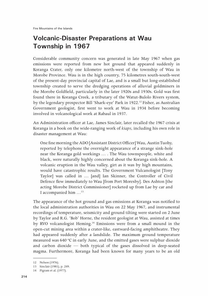
Volcanic-Disaster Preparations at Wau Township in 1967
Considerable community concern was generated in late May 1967 when gas emissions were reported from new hot ground that appeared suddenly in Koranga Crater, only one kilometre north-west of the township of Wau in Morobe Province. Wau is in the high country, 75 kilometres south-south-west of the present-day provincial capital of Lae, and is a small but long-established township created to serve the dredging operations of alluvial goldminers in the Morobe Gold�eld, particularly in the later 1920s and 1930s. Gold was �rst found there in Koranga Creek, a tributary of the Watut-Bulolo Rivers system, by the legendary prospector Bill ‘Shark-eye’ Park in 1922.12 Fisher, as Australian Government geologist, �rst went to work at Wau in 1934 before becoming involved in volcanological work at Rabaul in 1937.
An Administration o�cer at Lae, James Sinclair, later recalled the 1967 crisis at Koranga in a book on the wide-ranging work of kiaps, including his own role in disaster management at Wau:
One �ne morning the ADO [Assistant District O�cer] Wau, Austin Tuohy, reported by telephone the overnight appearance of a strange sink-hole near the Koranga gold workings … . The Wau townspeople, white and black, were naturally highly concerned about the Koranga sink-hole. A volcanic eruption in the Wau valley, girt as it was by high mountains, would have catastrophic results. The Government Vulcanologist [Tony Taylor] was called in … [and] Ian Skinner, the Controller of Civil Defence �ew immediately to Wau [from Port Moresby]. Des Ashton [the acting Morobe District Commissioner] rocketed up from Lae by car and I accompanied him …13
The appearance of the hot ground and gas emissions at Koranga was noti�ed to the local administration authorities in Wau on 22 May 1967, and instrumental recordings of temperature, seismicity and ground tilting were started on 2 June by Taylor and R.G. ‘Bob’ Horne, the resident geologist at Wau, assisted at times by RVO volcanologist Heming.14 Emissions were from a small mound in the open-cut mining area within a crater-like, eastward-facing amphitheatre. They had appeared suddenly after a landslide. The maximum ground temperature measured was 640 ºC in early June, and the emitted gases were sulphur dioxide and carbon dioxide — both typical of the gases dissolved in deep-seated magma. Furthermore, Koranga had been known for many years to be an old
12 Nelson (1976).13 Sinclair (1981), p. 249.14 Pigram et al. (1977).
10. Plate Tectonics and False Alarms: 1960–1972
215
eruptive centre, and its geologically youthful rocks to be of volcanic origin.15 Taylor raised the possibility of large-scale volcanic activity and recommended the preparation of an evacuation plan.16 Sinclair recalled the e�ort involved in producing it:
For days we laboured, preparing an emergency evacuation plan. The best escape routes were decided upon, numbers of people involved listed, available vehicles counted, food stocks calculated, medical resources evaluated and detailed instructions written out, covering every conceivable complication and consequence. Planning of this nature is mainly a matter of identifying and assessing probable escalations of danger, and slavish attention to detail to ensure that nothing is overlooked — not vivacious work, and very tiring.17
Figure 83. Koranga Crater is seen from the east after the landslide of May 1967. The active mound of hot ground and gas emission is shown by the arrow.
Source: Pigram et al. (1977, Figure 3). Geoscience Australia (GA-9081).
The Wau Evacuation Plan was released on 16 June 1967 and contained the following introductory statement, based on Taylor’s scienti�c advice: ‘It is
15 See, for example, Fisher & Branch (1981).16 Taylor (1967).17 Sinclair (1981), p. 249.
Fire Mountains of the Islands
216
possible that the volcanic vent in the Koranga open cut (Koranga Crater) will increase in activity and that a volcanic eruption of dangerous proportions could follow’.18 Additional information on the nature of the hot ground and gas emissions was collected in the following days and weeks, however, and doubts began to emerge that they were truly volcanic in origin, and especially when they disappeared altogether after another landslide in the open cut in mid-August 1967.19 The crisis ended and the emergency evacuation plan was never used.
Not only did the lifespan of the emissions and the active mound at Koranga seem to have been governed by the landslides, but water vapour — a normally abundant component of active volcanic systems — was virtually absent, especially after the mound and nearby landslide material dried out. Furthermore, there was no indication from the seismic, tilt and acoustic observations that a magma body underlay the open cut. Such a body, in any case, would have been expected to have a wider thermal e�ect on the surface when compared with the actual small size of the active mound. Some geologists later maintained that hydrothermal eruptions may well have taken place at Koranga in 1967 and simply were not witnessed by local people.20 This seems most unlikely.
The origin of the hot ground and gas emissions at Koranga was probably the result of the oxidation of reactive iron pyrites and carbonaceous materials in the altered rocks of the open cut, such as can cause �res in underground mines.21 The sulphur-bearing pyrites began burning when the initial landslide allowed access of oxygen, so producing the sulphur dioxide, and the carbonaceous materials ignited to form the carbon dioxide.
There is today some irony in the initial statements made in 1967 that the hot ground and gas emissions at Koranga signi�ed a possible volcanic eruption, if the reactive iron-pyrites interpretation is correct. Karl Sapper, the young German volcanologist who had visited German New Guinea in 1908, wrote the following in 1931, then as a well respected international scientist reviewing centuries-old explanations for volcanic activity:
The gradual development of Chemistry �rst suggested to L. de Capoa, in 1683, that volcanic heat originated in chemical processes. After Martin Lyster, in 1693, had called attention to the decomposition of pyrites, and [Nicolas] Lemery in 1700 o�ered experimental proof (spontaneous
18 Skinner (1967), p. 1.19 Pigram et al. (1977).20 Sillitoe et al. (1984).21 Pigram et al. (1977).
10. Plate Tectonics and False Alarms: 1960–1972
217
combustion of a mix of iron �lings and sulphur buried in moist earth) of the possibility of explosions from chemical processes, this opinion prevailed for a long time.22
Chemical processes were the likely cause of the crisis at Wau in 1967, but were not a precursor to any actual volcanic eruption. The Koranga crisis was a volcanic ‘false alarm’.
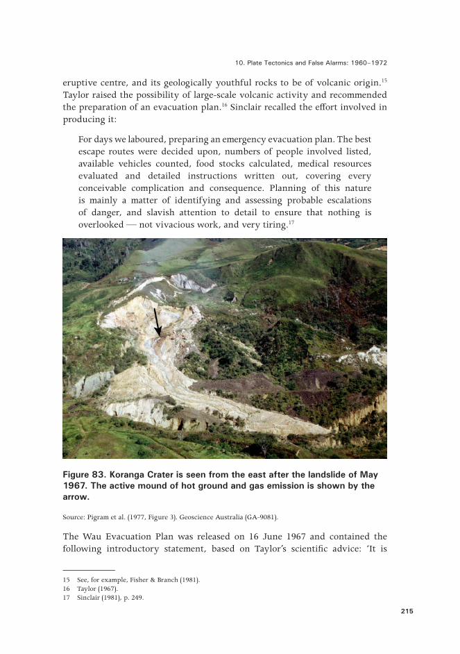
Evacuation from Dawson Strait in 1969
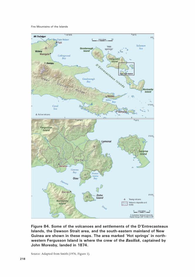
Perhaps the most signi�cant crisis in any volcanic area in Near Oceania in the 1960s took place in the Dawson Strait area of the D’Entrecasteaux Islands in eastern Papua. A series or ‘swarm’ of local earthquakes was felt around Easter time in 1969, particularly by people on Dobu Island, on south-eastern Fergusson Island, and on north-western Normanby Island, where the Administration had its headquarters at Esa’ala.
Monica Russell was a school teacher at Salamo on the south-east coast of Fergusson Island across the strait from Esa’ala, and wrote in her diary for Saturday 5 April 1969: ‘What a day! It started o� at just after 4 am with a tremor. There were quite a few and a very strong one ... just about 4.45 am Esa’ala recorded 14 in two hours.’23 Then later that evening: ‘Just got into bed when there was a very strong shake — things fell again … . We had little shakes then on and o� all through the night.’ Another teacher, Lucille Piper, said many years later that her easel blackboard immediately began to dance at the beginning of a tremor, alerting her and the students to get prepared for an ensuing ‘shake’.24
Dawson Strait in 1969 was well known as an area of young, potentially active volcanoes, three of them conspicuous landmarks. Dobu Island itself is the summit of a volcano built up from the sea �oor in the strait, and Oiau and Lamonai are small volcanic peaks several kilometres to the north of Dobu on Fergusson Island.25 In addition, the numerous quasi-permanent geothermal areas of the D’Entrecasteaux Islands, including the well-known Dei Dei hot spring area near Oiau, were another reminder of active volcanic processes and prospective volcanic eruptions in the area. There is, however, no documentation of historical eruptive activity at Dobu, Oiau or Lamonai, nor any reliable local stories of any volcanic eruptions having taken place in the more distant past.
22 Sapper (1931), p. 19.23 M. Russell (personal communication, 2009; from a transcript of her diary entries for 6–12 April 1969). Documented information on the Dawson Strait crisis in 1969 is scant, and much of the material presented here is based on personal communications during 2008–2010 with individuals who were there at the time. The late Herman Patia assisted greatly in disinterring information on the crisis.24 L. Piper (personal communication, 2008). 25 Taylor (1955) and Smith (1976, 1981).
Fire Mountains of the Islands
218
Figure 84. Some of the volcanoes and settlements of the D’Entrecasteaux Islands, the Dawson Strait area, and the south-eastern mainland of New Guinea are shown in these maps. The area marked ‘Hot springs’ in north-western Fergusson Island is where the crew of the Basilisk, captained by John Moresby, landed in 1874.
Source: Adapted from Smith (1976, Figure 1).
10. Plate Tectonics and False Alarms: 1960–1972
219
April 1969 was not the �rst time that local earthquakes had been felt in the Esa’ala area. Seismic events in 1953–1957, for example, are particularly noteworthy because, so soon after the volcanic disaster in 1951 at Lamington volcano to the west, on the mainland of New Guinea Island, the earthquakes had ‘alarmed local inhabitants and government o�cers responsible for the welfare of the people.’26 Taylor, by late 1953, had arranged for a volcanological reporting scheme to be established through which Territory Administration o�cials in volcanically active districts could report earthquakes and any changes within the volcanic areas to RVO, and numerous felt earthquakes, seismic ‘swarms’, aftershocks, and ‘tremors’ were reported by this mechanism from the Esa’ala district and other nearby places between October 1953 and February 1957.27 The precise location of the earthquakes was uncertain, but many appeared to have taken place beneath the sea �oor in Gomwa Bay, immediately west of Oiau volcano. Taylor and RVO volcanologist Reynolds both speculated that these local and shallow earthquakes could be part of a longer sequence of tectonic earthquakes dating from 1939, which had a�ected eastern Papua as a whole — that is, an extended period of general geophysical unrest which also included the volcanic eruptions at Goropu in 1943 and Lamington in 1951. They feared that the 1953–1957 earthquakes, although probably tectonic in origin, could be precursors to further volcanic activity somewhere in the general area of south-eastern Fergusson Island and Dobu Passage. This concern was the reason why Taylor, during the 1951–1957 eruption time cluster throughout the Territory, urged the construction of the volcanological observatory at Esa’ala in order to monitor any potentially threatening volcanic activity. The observatory, including an instrumental cellar housing a seismograph and tiltmeter, was built at Esa’ala in 1964.
The earthquakes of Saturday 5 April 1969, and those in the days following, caused consternation and anxiety, particularly amongst those people who were feeling them most strongly. About 5–7 shocks per day were being felt at intensities I–III on the Modi�ed Mercalli Intensity Scale.28 The earthquakes seemed to be taking place at or near Dobu volcano, so the possibility of volcanic eruptions was foremost in the minds of many people, including the Administration o�cers at Esa’ala. An Australian newspaper journalist on Wednesday 9 April reported on the earthquake activity and community fears, mentioning that on the previous day the District Commissioner for Milne Bay, Max Denehey, who was based in Alotau, had announced that a government trawler carrying extra food and medical supplies was on its way to the area as a precautionary measure, and that people on isolated Dobu Island might have
26 Reynolds (1957), p. 1. 27 Taylor (1955) and Reynolds (1956, 1957).28 D’Addario (1969a).
Fire Mountains of the Islands
220
to be evacuated.29 The Assistant District Commissioner at Esa’ala, J. Edwards, was quoted as saying that the seismic activity was declining. Nevertheless, an evacuation of Dobu Island was well underway by Thursday 10 April, following recommendations made by the authorities at Esa’ala.30 Some villagers may well have decided to leave their homes before the o�cial declaration and, indeed, a later RVO report contains the statement that ‘villagers evacuated spontaneously from the coasts …’31 Ian Skinner, Director of Civil Defence in Port Moresby �ew over the area on Thursday 10 April and noted about 30 canoes crossing the strait between Dobu and Normanby Island.32 The evacuation was seen to be orderly and voluntary. People from Dobu joined others moving away from the island and from Esa’ala to other more distant and safer parts of the Normanby Island coast.
Evacuees were also moving westwards and purposefully along the south-eastern coast of Fergusson Island towards the safer Morima area on the west coast, or they stopped o� with relatives or friends along the way.33 These evacuees included people from the Oiau-Lamonai and Dei Dei hot spring areas on Fergusson as well as from Dobu Island. Several hundred people came along the track near the mission, schools, and hospital complex at Salamo, in a long line carrying personal belongings, some with a pig in tow, while teachers were trying to run school classes. Some children at the schools ran out to meet family members amongst the evacuees. Salamo itself was not evacuated, although preparations were made for a quick departure if necessary for school and hospital sta�, students, and patients. Arrangements were made with the government authorities in Esa’ala to wait for further directions:
The signal to leave was to be �ares let o� at Esa’ala, so two school boys were posted down at the shore at Gomwa village to keep watch each night and if a �are went o� they were to run back to the station to get the generator started. This would put the station lights on which would be the signal to move out …34
RVO volcanologist D’Addario visited the Dawson Strait area from 10 to 15 April to assess the nature of the earthquakes and to inspect the condition of
29 Sydney Morning Herald (1969a).30 R. Morioga (personal communication, 2009, to Herman Patia at RVO). Ruben Morioga worked for the Administration in April 1969 as a court interpreter. He accompanied patrol o�cers during their visits to villages throughout the D’Entrecasteaux Islands. Morioga recalled two policemen being instructed by John Absalom at Administration headquarters to travel by dinghy to Dobu Island, south Fergusson Island, and north Normanby Island, and there to inform villagers that they should get ready to move out. Morioga later joined RVO as a part-time observer at the Esa’ala Volcanological Observatory.31 D’Addario (1969a), p. 5.32 Sydney Morning Herald (1969b).33 Former school teachers at Salamo who kindly provided information in 2008–2010 are Heather Anderson, John Beasley, Rev. Lucille Piper, Pat Riddell, Sheila Rudofsky and Monica Russell.34 L. Piper (personal communication, 2008).
10. Plate Tectonics and False Alarms: 1960–1972
221
the volcanoes.35 He concluded that there were no indications that any of the volcanoes would break out in eruption. There may have been some changes to the geothermal areas but these were not regarded as volcanologically signi�cant. The earthquakes were reported by D’Addario to have taken place under Gomwa Bay to the west of Oiau and north-west of Dobu and, therefore, not directly under either volcano — or under the more distant Lamonai volcano. The District Commissioner was informed of the results of the volcanological inspection and evacuees began the return to their homes and more normal lives soon after 15 April, although occasional earthquakes continued to be felt. RVO volcanologists continued to visit Esa’ala, and there was a strong local earthquake on 11 July.36 Furthermore, the district medical o�cer at Samarai, Dr M. Powell, distributed to health workers throughout the Milne Bay District an outline of action, dated 19 August, that should be followed in the event of a volcanic emergency at Esa’ala.37 The 1969 ‘crisis’, as far as local people were concerned, had lasted, however, for only two or three weeks in April. The exact number of people who evacuated during this volcanic ‘false alarm’ is unknown, but it was certainly more than 1,000 and probably more than 2,000.38
Origin of the Dawson Strait Earthquakes and a Note on Volcanic False Alarms
What was the cause of the earthquakes in Dawson Strait in 1969? How did they originate if they were not volcanic in origin — that is, caused by the movement of magma beneath the volcanoes? The year 1969 was when seismologists in Near Oceania were beginning to interpret earthquakes in terms of the theory of plate tectonics and to map and publish on the exceptionally complex pattern of plate boundaries in the region.39 The Woodlark Basin, immediately to the east of the D’Entrecasteaux Islands, was identi�ed in 1970 as a divergent or sea �oor spreading type of plate boundary, where plates move apart from each
35 D’Addario (1969a, 1969b).36 D’Addario (1969a, p. 6) wrote brie�y that a Willmore portable seismograph was installed near Oiau volcano between 20 and 29 July 1969. Epicentres for weak earthquakes were calculated and were identi�ed as corresponding ‘… to two areas, one near the Dobu Passage and the other between Cape Dawson [probably Sebulugomwa Point] and Bomwa [Gomwa] Bay. These two areas coincide with the two previous locations indicated during the April [earthquake] storm’. This is the only known reported evidence of the earthquakes having taken place in two separate areas. D’Addario (1969b) also noted that a ‘seismic swarm’ had taken place in the Esa’ala area on 19 and 20 November 1968 — that is, only �ve months before the April 1969 earthquakes — but there are no further details about their strength or location. Reynolds (1956) also reported earthquakes in the Gomwa Bay area in 1955.37 Powell (1969).38 R. Morioga (personal communication, 2009, to Herman Patia at RVO) suggested that the number of evacuees may have exceeded 3,000.39 Denham (1969).
Fire Mountains of the Islands
222
other — in this case to the north and south.40 Geoscientists have since taken a particular research interest in trying to identify what happens to this plate boundary when it is traced westwards towards the D’Entrecasteaux Islands and the south-eastern end of New Guinea Island. The details are still not clear, given that much of this area is covered by sea, but there is a general consensus that the area is being rifted tectonically, and probably complexly, and that it has not, or not yet, produced the kind of sea �oor spreading observed in the Woodlark Basin to the east. Some geophysicists in the early 1970s traced a single plate boundary through the general area of the D’Entrecasteaux Islands, including some who proposed speci�cally that the boundary runs along Dawson Strait between Fergusson and Normanby islands.41 The earthquakes of 1969, and at other times in Dawson Strait, would therefore seem to be related to the tectonic release of seismic energy along a plate boundary, or at least to a geological structure related to it, rather than directly to a volcanic origin.
Mention of geological ‘rifting’ in the D’Entrecasteaux Islands perhaps brings to mind the Rift Valleys of East Africa. The comparison is, of course, somewhat inappropriate, given the great size of the magni�cent rift escarpments and the vast volcanic regions in, for example, Kenya and Ethiopia. Nevertheless, there is a signi�cant similarity. Rocks from the diminutive D’Entrecasteaux Islands include a type of rhyolite lava, including obsidian, which resembles in some ways the kind of rhyolite found in St Andrew Strait in the Bismarck Sea and from Talasea, New Britain. Petrologists, however, can make a clear chemical distinction between these three rhyolite types. The ‘rhyolite’ of the D’Entrecasteaux Islands is in fact ‘comendite’, a rare rock type, which, while not found elsewhere in Near Oceania, exists in places such as East Africa. Its presence in the D’Entrecasteaux Islands is therefore regarded by geologists as being consistent with a rifted or extensional tectonic environment.42
There is value in considering further the nature of the ‘false alarm’ at Dawson Strait in 1969. At least two general types of volcanic false alarm can be distinguished. The �rst type is where a community has a local volcanological observatory which is well equipped with an array of modern volcano-monitoring equipment, is sta�ed by experienced scientists and technicians, and is sited on a frequently active volcano where the precursory signs of an impending eruption are well known. Such observatories will also have strong telecommunication links with authorities as well as a staged alert or early warning system, known to the community, which can be used to inform decisions on early evacuation. The sta� of these observatories can accrue considerable kudos if they are successful in alerting communities before the advent of a disastrous volcanic eruption.
40 Milsom (1970).41 See, for example, Curtis (1973).42 Smith (1976).
10. Plate Tectonics and False Alarms: 1960–1972
223
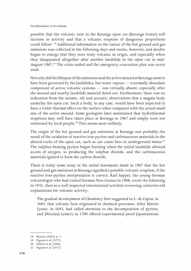
Conversely, however, the term ‘false alarm’ can carry a great deal of criticism if such an observatory recommends an evacuation but no eruption follows or, worse, declares there is no reason for community alarm and yet a devastating eruption does take place. Elements of such a situation emerged in Rabaul in 1994, for example.
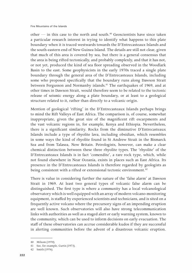
Figure 85. Geoscientists still debate the question of how many plates and plate boundaries exist in the tectonically complex Near Oceania region, but in this map as many as five minor tectonic plates —Caroline, North Bismarck, South Bismarck, Solomon Sea, and Woodlark — are shown sandwiched between the much larger Pacific and Australian tectonic plates. Note how the Woodlark Basin plate boundary or ‘spreading centre’ is shown running through Dawson Strait in the D’Entrecasteaux Islands.
Source: Finlayson et al. (2003, adapted from Figure 1). Reproduced with the permission of Elsevier.
The second type of false alarm is where a community in a potentially active volcanic area, which is unmonitored instrumentally and has no volcanological observatory, becomes alarmed by apparent geophysical changes such as felt volcanic earthquakes, visible landslides on volcanoes, or the appearance of hot ground and gases, and a�ected people then inform local authorities. Professionally trained volcanologists are then called in to assess the situation, but the threat dies down, the crisis is called a ‘false alarm’ and life returns more or less to normal. This was the situation, for example, at Koranga in 1967.
Fire Mountains of the Islands
224
The false alarm at Dawson Strait in 1969 does not fall neatly into either of these two general categories. The volcanological observatory at Esa’ala was established in 1964 to monitor precursory geophysical signs of possible volcanic activity because of the local earthquakes known to have taken place there. Evacuation in 1969 took place solely because of local fears of the strong April earthquakes, rather than because of any early warning or alert from sta� of the Esa’ala Volcanological Observatory. There were no trained scientists at the observatory in 1969, and professional volcanological opinion from Rabaul on the happenings in Dawson Strait came only later, after the worst of the seismic crisis was over and when the seismic records — and those from portable recorders that were deployed later for short periods — could be examined. No full scienti�c report was ever completed on the Dawson Strait seismic activity in 1969. Indeed, the challenge of relating the tectonic earthquakes in the Dawson Strait area to the sub-surface formation of magma and therefore possible volcanic eruptions has never been addressed properly.
One �nal conclusion is that the capital outlay in 1964 for a permanent observatory, including an instrument cellar, at Esa’ala has yet to justify its volcanological worth, bearing in mind that no volcanic eruptions have taken place there in the centuries since written records began to be kept in the area. The volcanoes of the Dawson Strait area must still be regarded as having the potential for future volcanic outbreaks, but the key contemporary question is reduced to whether the expense of maintaining and operating the Esa’ala Volcanological Observatory can be justi�ed given the relatively low volcanic risk in the strait, compared with other unmonitored volcanoes in Near Oceania. Volcano-monitoring technologies have improved dramatically since 1969 and an old-style observatory such as that erected at Esa’ala in 1964 would probably never be built today.
Tectonic Earthquakes and the End of the Taylor Era
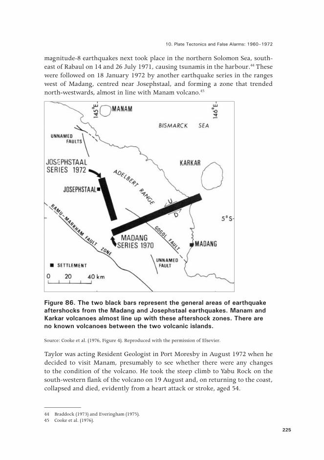
Four major series of tectonic earthquakes shook New Britain and the north coast of New Guinea over a 15-month period in 1970–1972, and their epicentres were su�ciently close to volcanoes that Taylor was alert to the prospect of new eruptions. I recall him returning to Canberra in late 1970 after the Madang earthquake of 31 October that year, excited — for a normally quiet, cautious, and at times non-communicative man. He said that he had seen changes to the thermal areas in the caldera of nearby Karkar Island,43 and thought they represented a prelude to new eruptive activity from the volcano. Two
43 Taylor (1972).
10. Plate Tectonics and False Alarms: 1960–1972
225
magnitude-8 earthquakes next took place in the northern Solomon Sea, south-east of Rabaul on 14 and 26 July 1971, causing tsunamis in the harbour.44 These were followed on 18 January 1972 by another earthquake series in the ranges west of Madang, centred near Josephstaal, and forming a zone that trended north-westwards, almost in line with Manam volcano.45
Figure 86. The two black bars represent the general areas of earthquake aftershocks from the Madang and Josephstaal earthquakes. Manam and Karkar volcanoes almost line up with these aftershock zones. There are no known volcanoes between the two volcanic islands.
Source: Cooke et al. (1976, Figure 4). Reproduced with the permission of Elsevier.
Taylor was acting Resident Geologist in Port Moresby in August 1972 when he decided to visit Manam, presumably to see whether there were any changes to the condition of the volcano. He took the steep climb to Yabu Rock on the south-western �ank of the volcano on 19 August and, on returning to the coast, collapsed and died, evidently from a heart attack or stroke, aged 54.
44 Braddock (1973) and Everingham (1975).45 Cooke et al. (1976).
Fire Mountains of the Islands
226
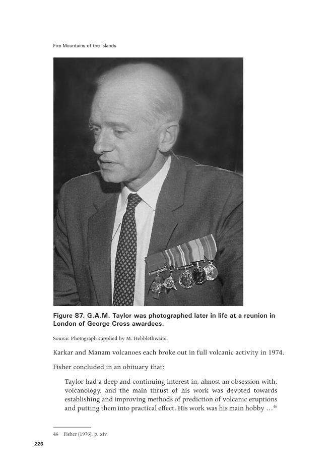
Figure 87. G.A.M. Taylor was photographed later in life at a reunion in London of George Cross awardees.
Source: Photograph supplied by M. Hebblethwaite.
Karkar and Manam volcanoes each broke out in full volcanic activity in 1974.
Fisher concluded in an obituary that:
Taylor had a deep and continuing interest in, almost an obsession with, volcanology, and the main thrust of his work was devoted towards establishing and improving methods of prediction of volcanic eruptions and putting them into practical e�ect. His work was his main hobby …46
46 Fisher (1976), p. xiv.
10. Plate Tectonics and False Alarms: 1960–1972
227
Taylor’s work was both pioneering and impressive, yet his premature death meant he did not complete a planned report on the major eruptions at Manam in 1957–1960. Nor was he able to compile into a de�nitive account his �nal assessment of the ‘three component’ eruption-prediction model that he had been testing over the previous 20 years, and which included the in�uence of tectonic activity on eruption triggering.
Taylor died the year before Papua New Guinea became self-governing in 1973 and, in a sense, his death marks the end of a ‘colonial’ era in applied volcanology in Near Oceania. These times had become overarched by great political change in the Paci�c region as old colonies and territories became new nation-states. Papua New Guinea obtained its independence in 1975 and Solomon Islands in 1978, each inheriting national boundaries that had been determined as a result of bargaining by the colonial powers of the late nineteenth century. The new nations were characterised as ‘developing’ or Third World. They were cast into a modern world that, increasingly, was becoming globalised and where the more fortunate ‘developed’ countries o�ered �nancial assistance as a mechanism for sharing global wealth and establishing political in�uence. Volcano monitoring and disaster management became the responsibility of the new sovereign states, but volcanological leadership in Rabaul and Honiara continued in the hands of seconded, or contracted, expatriate Europeans.
References
Allen, B.J. & A.W. Wood, 1980. ‘Legendary Volcanic Eruptions and the Huli, Papua New Guinea’, Journal of the Polynesian Society, 89, pp. 341–47.
Ballard, C., 1998. ‘The Sun by Night: Huli Moral Topography and Myths of a Time of Darkness’, in L.R. Goldman & C. Ballard (eds), Fluid Ontologies: Myth, Ritual and Philosophy in the Highlands of Papua New Guinea. Bergin and Garvey, Westport, Connecticut, pp. 67–85.
Blong, R.J., 1979. ‘Huli Legends and Volcanic Eruptions, Papua New Guinea’, Science, 10, no. 3, pp. 93–94.
Braddock, R.D., 1973. ‘The Solomon Sea Tsunamis of July 1971’, in R. Fraser (comp.), Oceanography of the South Paci�c 1972. New Zealand Commission for UNESCO, Wellington, pp. 9–14.
Branch, C.D., 1967. ‘Volcanic Activity at Mount Yelia, New Guinea’. Bureau of Mineral Resources, Canberra, Report 107, pp. 35–39.
Fire Mountains of the Islands
228
Bultitude, R.J., 1979. Bagana Volcano, Bougainville Island: Geology, Petrology, and Summary of Eruptive Activity between 1875 and 1975. Geological Survey of Papua New Guinea Memoir, 6.
Cooke, R.J.S. Cooke, C.O. McKee, V.F. Dent & D.A. Wallace, 1976. ‘Striking Sequence of Volcanic Eruptions in the Bismarck Volcanic Arc, Papua New Guinea, in 1972–75’, in R.W. Johnson (ed.), Volcanism in Australasia. Elsevier, Amsterdam, pp. 149–172.
Curtis, J.W., 1973. ‘Plate Tectonics and the Papua – New Guinea – Solomon Islands Region’, Journal of the Geological Society of Australia, 20, pp. 21–36.
D’Addario, G.W., 1969a. ‘Interim Progress Report for 1969, Volcanological Section’. Unpublished manuscript, Rabaul Volcanological Observatory.
——, 1969b. Monthly Reports of the Rabaul Volcanological Observatory, April to July.
Denham, D., 1969. ‘Distribution of Earthquakes in the New Guinea – Solomon Islands Region’, Journal of Geophysical Research, 74, pp. 4290–99.
Everingham, I.B., 1975. ‘Faulting Associated with the Major North Solomon Sea Earthquakes of 14 and 26 July 1971’, Journal of the Geological Society of Australia, 22, pp. 61–69.
Finlayson, D.M., O. Gudmundsson, I. Itikarai, Y. Nishimura & H. Shimamura, 2003. ‘Rabaul Volcano, Papua New Guinea: Seismic Tomographic Imaging of an Active Caldera’, Journal of Volcanology and Geothermal Research, 124, pp. 153 –71.
Fisher, N.H., 1976. ‘Memorial — G.A.M. Taylor’, in R.W. Johnson (ed.), Volcanism in Australasia. Elsevier, Amsterdam, pp. ix–xiv.
Fisher, N.H. & C.D. Branch, 1981. ‘Late Cainozoic Volcanic Deposits of the Morobe Gold�eld’, in R.W. Johnson (ed.), Volcanism in Australasia. Elsevier, Amsterdam, pp. 249–55.
Glasse, R.M., 1963. ‘Bingi at Tari’, Journal of the Polynesian Society, 72, pp. 270–71.
Mackenzie, D.E. & R.W. Johnson, 1984. ‘Pleistocene Volcanoes of the Western Papua New Guinea Highlands: Morphology, Geology, Petrography, and Modal and Chemical Analyses’. Bureau of Mineral Resources, Canberra, Report 246.
Milsom, J.S., 1970. ‘Woodlark Basin, a Minor Center of Sea-Floor Spreading in Melanesia’, Journal of Geophysical Research, 75, pp. 7335–39.
10. Plate Tectonics and False Alarms: 1960–1972
229
Moore, J.G., 1967. ‘Base Surge in Recent Volcanic Eruptions’, Bulletin Volcanologique, 30, pp. 337 –63.
Nelson, H.E., 1971. ‘Disease, Demography, and the Evolution of Social Structure in Highland New Guinea’, Journal of the Polynesian Society, 80, pp. 204–16.
——, 1976. Black, White and Gold: Goldmining in Papua New Guinea 1878–1930. The Australian National University Press, Canberra.
Newstead, G., 1969. ‘Keeping Watch on Volcanoes’, Hemisphere, 13, no. 1, pp. 32–37.
Pigram, C.J., R.W. Johnson & G.A.M. Taylor, 1977. ‘Investigation of Hot Gas Emissions from Koranga Volcano, Papua New Guinea, in 1967’, BMR Journal of Geology and Geophysics, 2, pp. 59–62.
Powell, M., 1969. ‘Volcanic Disturbances — Esa’ala’. Department of Public Health, Samarai, Milne Bay District. Photocopy of unpublished memorandum supplied by A. Speer (personal communication, 2011).
Reynolds, M.A., 1956. ‘The Gomwa Bay (D’Entrecasteaux Islands) Earthquakes: July–September, 1955’, Bureau of Mineral Resources, Canberra, Record 1956/7.
——, 1957. ‘Volcano—Seismic Phenomena in Eastern Papua since 1939’, Bureau of Mineral Resources, Canberra, Record 1957/14.
Sapper, K., 1931. ‘Volcanoes, their Activity and their Causes’. Physics of the Earth — I: Volcanology, Bulletin of the National Research Council, National Academy of Sciences, 77, pp. 1–33.
Sillitoe, R.H., E.M. Baker & W.A. Brook, 1984. ‘Gold Deposits and Hydrothermal Eruption Breccias Associated with a Maar Volcano at Wau, Papua New Guinea’, Economic Geology, 79, pp. 638–55.
Sinclair, J., 1981. Kiap: Australia’s Patrol O�cers in Papua New Guinea. Paci�c Publications, Sydney.
Skinner, R.I., 1967. Wau Evacuation Plan — Advice to Residents. Civil Defence and Emergency Services, Territory of Papua and New Guinea, 17 June.
Smith, I.E.M., 1976. ‘Peralkaline Rhyolites from the D’Entrecasteaux Islands, Papua New Guinea’, in R.W. Johnson (ed.), Volcanism in Australasia. Elsevier, Amsterdam, pp. 275–85.
Fire Mountains of the Islands
230
——, 1981. ‘Young Volcanoes in Eastern Papua’, in R.W. Johnson (ed.), Cooke-Ravian Volume of Volcanological Papers. Geological Survey of Papua New Guinea Memoir, 10, pp. 257–65.
Sydney Morning Herald, 1969a. ‘N.G. Volcanoes Active: Relief Ship on Way as Precaution’, Wednesday 19 April, p. 3.
——, 1969b. ‘Canoes Ferry Islands from Volcano Threat’, Friday 11 April, p. 5.
Taylor, G.A., 1955. ‘Notes on Volcanic Activity and Thermal Areas in the D’Entrecasteaux Islands’, Bureau of Mineral Resources, Canberra, Record 1955/75.
——, 1966. ‘The Surveillance of Volcanoes in the Territory of Papua and New Guinea’, South Paci�c Bulletin, 16, no. 2, pp. 15–20.
——, 1967. ‘Notes on an Evacuation Plan for Wau in the Events of Volcanic Emergency’. Unpublished typescript, R.W. Johnson collection, Canberra, 13 June.
——, 1971. ‘An Investigation of Volcanic Activity at Doma Peaks’. Bureau of Mineral Resources, Canberra, Record 1971/137.
——, 1972. ‘Karkar Island’, in Johnson et al., Geology and Petrology of Quaternary Volcanic Islands o� the North Coast of New Guinea. Bureau of Mineral Resources, Canberra, Record 1972/21, pp. 63–70.
Watson, J.B., 1963. ‘Krakatoa’s Echo?’, Journal of the Polynesian Society, 72, pp. 152–55.


![Car Alarms & Smoke Alarms [Monitorama]](https://img.pdfslide.us/doc/110x75/54b6cdf94a7959d84d8b45a5/car-alarms-smoke-alarms-monitorama.jpg)