Embed Size (px)
Citation preview

10
HO-21 UNITED STATES DEPARTMENT OF THE INTERIOR STATE
NATIONAL PARK SERVICE M a r y l a n d
COUNTY
NATIONAL REGISTER OF HISTORIC P L A C E S Howard
INVENTORY - NOMINATION FORM E N T RY DATE
(Typo all entries - complete applicable sections)
NAME
C O M M O N :
Waverley A N D ' O H H I S T O B I C :
L O C A T I O N ! | S T R E E T AND N U M B E R
E a s t S i d e M a r r i o t t s v i l l e Road , 1/2 m i l e N o r t h o f J u n c t i o n / with Interstate 70 N. C I T Y OR TOWN: C O N G R E S S I O N A L D I S T R I C T
A p p r o x i m a t e l y 3 m i l e s s o u t h o f Marriotsville S i x t h S T A T E
M a r y l a n d C L A S S I F I C A T I O N
CATEGORY
(Chrck One)
£ | Dist r ic t X ; Bui ld ing
T~! Site Q j Structure
O Object
C O D E C O U N T Y : C O D E
24 Howard 027
OWNERSHIP
P Public
K ] Pr ivote
~ ] Both
Publ ic A c q u i s i t i o n :
~] In Process
[ 1 Be ing Considered
S T A T U S
3^ Occupied
~ 1 Unoc cupi ed
1 t Preservo l ion work
in p r o g r e s s
ACCESSIBLE
TO THE PUBLIC :
Y e s :
~ Rest r ic ted
] Unrestr ic ted
X j No
P R E S E N T USE (Check One or More fls Appropriate)
{ J Agr iculturol
1 | Commercial
| I Educolionol
[^J Entertainment
i l Government
1 1 Industr ial
i 1 Mil i tory
M Museum
Q Pork
X I Pr iva te Residence
i 1 Re l ig ious
I | Sc ient i f ic
[_ ] Transpor ta t ion
O Other (Specify)
[ X Comments
t e n a n t e d
4. OWNER OF PROPERTY
Ov.NL R's N AME:
L a r r y R e a l t y C o . , I n c . I T R k C T AND N U M B E R :
H i g h f a l c o n R d . C I T Y OR TOWN:
O w i n g s M i l l s 5. LOCATION OF LEGAL DESCRIPTION
-
S T A T E : .
M a r y l a n d ' - .ODF
24
)
ST
AT
I:
Mary
land
C O U R T H O U S E R E G I S T R Y O F D E E D S . E T C :
Howard County Cour thouse I s T R i I F E 1 A N D N U M U L R :
.C ITY OR TOWN:
E l l i c o t t City Maryland 24 6. REPRESENTATION IN EXISTING SURVEYS
I T I T L E OF S U R V E Y :
| Q A T r OF S U R V E Y : Q7, Federol f j j State • County Local
U I I ' O S n O R Y FOR S U R V E Y R E C O R D S :
S I I. I I" 1 A N D N UM B E R :
CM > Ol: 1 OWN

HO-21 D E S C R I P T I O N
(Check One)
I I Excel lent O Good Q Fair K l Deter ioroted ] Ruins [ZJ U n e x p o i e d C O N D I T I O N
(Click One) (Check One)
• A l tered Scj Una l te red f~\ Moved [JC Original Site
D E S C R I B E T H E P R E S E N T AND ORIGINAL, (it known; P H Y S I C A L A P P E A R A N C E
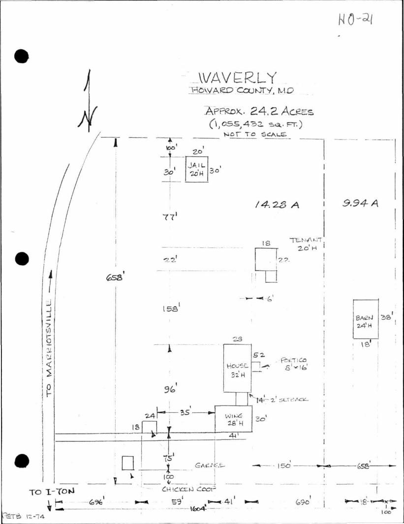
Waverley is located on the east side of the Marriottsville Road, one-half mile northeast of the intersection of the Marriottsville Road Interstate 70 N., in Howard County, Maryland.
Approached by a quarter mile long private drive, the mansion is impressively situated and commands a magnificant vista of the immediate countryside. Of massive proportions, its plan approximates an "ell" shape, with the main portion of the house facing east; a south wing connected to the south end of the main block by a stone hyphen, is positioned diagonally to it. Two stories in height and five bays in width, the main house, as with the hyphen and wing, is of stone construction now completely stuccoed. The fenestration of the east facade is symmetrically arranged but the size of the building is made more apparent by the wide spacing of proportionately small windows. The main entrance of this same elevation, with transom and double doors, is sheltered by a one story pedimented porch of a probable circa 1900 date of construction. The rear (west) elevation repeats the same treatment although the door is somewhat smaller. At the north end are tvjo small windows at each floor level, including the attic; on the south end most of the first floor is covered by the hyphen but the treatment is the same above that level. The expansive "A" frame roof has a single enclosed chimney at each end of the roof ridge; their great size physically contributes to the visual massiveness of the house. Most of the exterior detail, including the entrance doors, window sash, simple boxed cornices and stucco appears to date from the second or third quarter of the nineteenth century--sorne, the east porch and tin roofing, for instance, may date even later. Unfortunately the stucco, once scored to represent ashlar, has obliterated many original details, including the window and door heads and what appears to have been a molded watertable. At ground level on both the front and rear sides are small wood barred cellar windows; an exterior cellar entrance is positioned beneath the first floor window immediately to the north side of the east door.
The hyphen connecting the south wing to the main block is two bays wide on the east side, with the door positioned lower than an adjacent window; the ground level drops slightly in this area, hence the wing is on a lower level than the main block. The hyphen, containing a small stair and hall, marks the point where the levels change.
(See Continuation Sheet #1)

Form 10-300c UNITED STATES DEPARTMENT OF THE INTERIOR (Dec. 1968) NATIONAL PARK SERVICE
NATIONAL REGISTER OF HISTORIC P L ACES
INVENTORY - NOMINATION FORM
(Continuation Sheet) £ 1
(Number ell entries)
#7 Description (Continued)
The two story wing is better proportioned than the main house, having larger windows that, because of the somewhat smaller scale of this part of the building, are not lost in great expanses of vail area. The east end of the two story wing has two windows of twelve-over eight double hung sash at the first floor, one at the second floor positioned toward the southeast corner, and one small attic window beneath the gable peak. The south elevation is four bays in width at both floor levels. The two windows and two doors of the first floor level are sheltered by a one story circa 1900 porch. First and second floor windows are of twelve over eight sash. Centered on the roof ridge is a large stuccoed chimney.
The first floor interior of the main block consists of a centered stair hall flanked by single parlors. Much of the interior woodwork dates from about 1800-1820 but with some woodwork contempo-
i rary to the mid-nineteenth century. At one point both parlors were mace smaller by the introduction of a partition wall which created narrow halls on their east side; this is especially evident in the obvious change in woodwork. The partition has been removed but the evidence of its previous existence remains.
In the hall is a wide and rather awkwardly proportioned staircase which rises in several flights to the attic level. Its balustrade consists of a molded rail and turned balur.ters, the whole of .which, including a paneled stair closet and decorated step ends, appears to date about 1800-1820.
On the second floor level are four bedrooms off center hall; in the unfinished attic are two large chambers, one divided by a vertical board partition.
The wing contains two ground floor and two second floor rooms, each with fireplaces. Evidence of extensive fire damage in the attic accounts for the rather late (fourth quarter, nineteenth century) woodwork throughout the wing. The ell shaped hall in the hyphen''has two sets of stairs, one leading to the south parlor of the main block and the other to the second floor of the v.'ing; a third stair to the attic of the wing is positioned in the northeast corner of the second floor east chamber.
(Sec Continuation Sheet *2)
Maryland C O U N T Y
Howard
HO-21
FOR NPS USC ONLY
E N T I - V N U M P t IV

Form 10-300o (Dec. 1968)
UNITED STATES DEPARTMENT OF THE INTERIOR NATIONAL PARK SERVICE
NATIONAL REGISTER OF HISTOR IC P LACES
INVENTORY - NOMINATION FORM
(Continuation Shvet) u „
1 T A 1 t
M a r y l a n d HO-21 C O U N T Y
Howard FOR NPS USE ONLY
E N T R Y N U M B E R
(A'u-Tioer ell entries)
#7 Description (Continued)
Adjacent to the house are several noteworthy dependencies. One, said to have served the farm overseers house, is a small one and one-half story stone building with a gable facade. This structure was a true half-story as the wall plate rises up over two feet above the first floor ceiling line. The south end facade is two bays wide, with two small windows within the gable. Both sides have two windows and there is a filled in door at the first and two windows at the second floor level of the north end. At the north end is a large enclosed chimney and there is a full cellar. Across the front of the building is a one story frame addition consisting of one room and a porch. A second structure was once reputedly used as a combination storehouse and jail and,' although restorable, it is in extremely poor condition. A third building of significance is situated above a quarter mile east of the house along the original drive. It is a two story frame and stone corn crib with the frame storage part supported by two story rounded stone posts and stone ends. Of particular interest are large flat stones positioned beneath the one story high sills which serve as a deterrent to rodents attempting to reach the corn by scaling the posts.
Other known sites on the property include what once was one of several commodious log slave quarters. Of this particular structure only the foundations and chimney base remain. About one hundred yards southwest of the house is the shattered tombstone of "John Eager Howard, a son of George Howard, who died in 1838. Although the stone is still on the property the body was moved to Frederick, Maryland, many years ago.

SIGNIFICANCE HO-21
P E R I O D (Chech One or More as Appropriate)
[~l P r e - C o l u m b i a n ' Q 16th Century
Q 15th Century D 17th Century
0 18th Century
[*J 19th Century
(JJ 20th Century
S P E C I F I C D A T E I S 1 (II Applicable and Known)
AREAS O F S I G N I F I C A N C E (Chech One or More as Appropriate)
Abor ig inal
1 1 Preh is tor ic
• H is tor ic
| | Agr icul ture
3 Archi tecture
Q Art
j j Commerce
J Communicat ions
( J Conserva t ion
[ | Educat ion
j Engineer ing
J Industry
J Invent ion
I | Landscape
Arehi tecture
"j L i terature
| " I M i l i t a ry
[ J Music
• P o l i t i c a l
• R e l i g i o n / P h i .
losophy
[ | Science
3 Sculpture
] Socio l /Human-
itor ion
| | Theoler
| | Transportation
1 Urban Planning
[ X Other (Specify)
l oca l h i s to ry
S T A T E M E N T O F S I G N I F I C A N C E
The recorded history of the Waverley property begins about 1703 when it was a portion of a property known as Ranter's Ridge and owned by Thomas Browne. Approximately half of the total acreage was left to Thomas' son Nathan in 1756, including that part which is now known as Waverley.
The next known owner of Waverley was Nathan Dorsey who is traditionally (if erroneously) credited with the building of the house, about 1780. However, it appears from the various structural and decorative elements of the house that it was more likely built after Dorsey's death possibly as late as circa 1800-1820. The property was later acquired by General John Eager Howard, Governor of Maryland 1788-1791.
The property was one of many owned by General Howard although it is not believed that he actually lived here. General Howard then deeded the property to his son George Howard on his marriage in 1811 to Prudence Gough Ridgely of "Hampton," in a'djacent Baltimore County. George Howard, who led an active political life, including serving as Governor of Maryland from 1831-1833, as well as that of gentleman farmer, is believed to have been the one most likely to have built the house. The estate under the ownership of Governor Howard evidently prospered for the size of his property increased measurably between 1820 and 1846, the year of his death. Following his death the property was divided and sold. One of these tracts, which included the house, was eventually sold to Joseph Judick in 1863. The property was later owned by members of the Brosennes family, who retained ownership until about 19 50. The property is now jointly owned by a group of private Baltimore investors under the name Larry Realty Company and future uses of the remaining 279 acres are at this time undetermined.

9. MAJOR BIBLIOGRAPHICAL REFERENCES
HO-21
White, Frank F. The Governors of Maryland., Publ ica t ion No. 15, The Hall of Records Commission, 1970.
Colonel Thomas Dorsey Chapter, D.A.R. "Waverley," an a r t i c l e published in the Howard County Times. N.d.
_L 10. GEOGRAPHICAL DATA
L A T I T U D E AND LONGITUDE COORDINATES
DEFIN ING A R E C T A N G L E LOCATING THE P R O ° E R T Y
NW
N f
SE
L A T I T U DE
Degrees Minutes Seconds
LONGI TUDE
Degrees Minutes Seconds
L A T I T U D E AND L O N G I T J D E COORDINATE.?
DEFIN ING Thi_ Ltrs;TER POIN I OF A P n O P E R T Y OF LESS THAN TEN ACRES
L A T I T U D E
Degrees M i n u t e s Seconds
LONGI TUOC
Degrees Minutes Seconds
APPROXIMATE ACRE AGE OF NOMINATED P R O P E R T Y : A ACTQS
ILIST ALL STATES AND COUNTIES FOR P R O P E R T I E S OVERLAPPING STATE OR COUNTY BOUNDARIES
CODE COUNTY
COUNTY:
FORM PREPARED BY N AME AND Tl T L E :
J . Richard Rivoire ORGANl ZA TION
Maryland H i s t o r i c a l Trust D A T E
2/74 STREET AND NUMB&B:
2525 Riva Road CITY OR TOWN:
Annapolis 12. STATE LIAISON OFFICER CERT1FICA1 ION
As the des igna ted Sta te Lia ison Officer for the Na
tional His tor ic P re se rva t ion Act of 1966 (Pub l i c Law
89-665), I hereby nominate th i s property for inc lus ion
in the Nat iona l Reg is te r and certify that it has been
evaluated according tt» the c-i teria and procedures set
forth by the Nat ional Pa rk Service. The recommended
level of s ign i f i cance of this nominat ion i s :
Nat ional • s t a t e E l Loca l Q
Numc Orlando Ridout, IV
Title S ta te H i s to r i c P rese rva t ion Officer
Pate A n r - i l 9 5 , 1 Q 7 4
Maryland 2± NATIONAL REGISTER VERIFICATION
I hereby certify that th i s property is Included in the
National Reg i s te r .
Director, Oilier of Archeology and Historic Preec-rvation
D j ' e
ATTKST:
Keeper of The National Register
Date
GPO 93 I -e». J