Embed Size (px)
Citation preview
1
JANUARY 2018
FALL 2018
IN THIS ISSUE
Municipal Planning Can Improve Safety on Roads
Tech Assists: Featured Questions
PennDOT Connects— Powered by Communities Course Announced
Meet PennDOT District 6 Planner / Featured District 6 Project
Planners Address Trail Safety
BETTER COLLABORATION
TRANSFORM
The latest news and information from PennDOT Connects’ network of people and places
BETTER COMMUNITIES
Municipal Planning Can Improve Safety on Roads
(continued on page 2)
Intersections with conflict points, road departures at curves, and aggressive driving on rural highways — such road safety issues are common to Pennsylvania municipalities. Most likely, each issue has a technical, engineered solution. As a whole, however, your municipality’s road safety issues can be best addressed through big-picture planning, adopting ordinances that promote safety, and implementing proven safety measures.
PlanningPennDOT Connects encourages local officials to be proactive and incorporate road safety into planning initiatives. Start at the top with your comprehensive plan. According to the Municipalities Planning Code, a comprehensive plan must include “a plan for movement of people and goods, which may include expressways, highways, local street systems, parking facilities, pedestrian and bikeway systems, public transit routes, terminals, airfields, port facilities, railroad facilities, and other similar facilities or uses.”
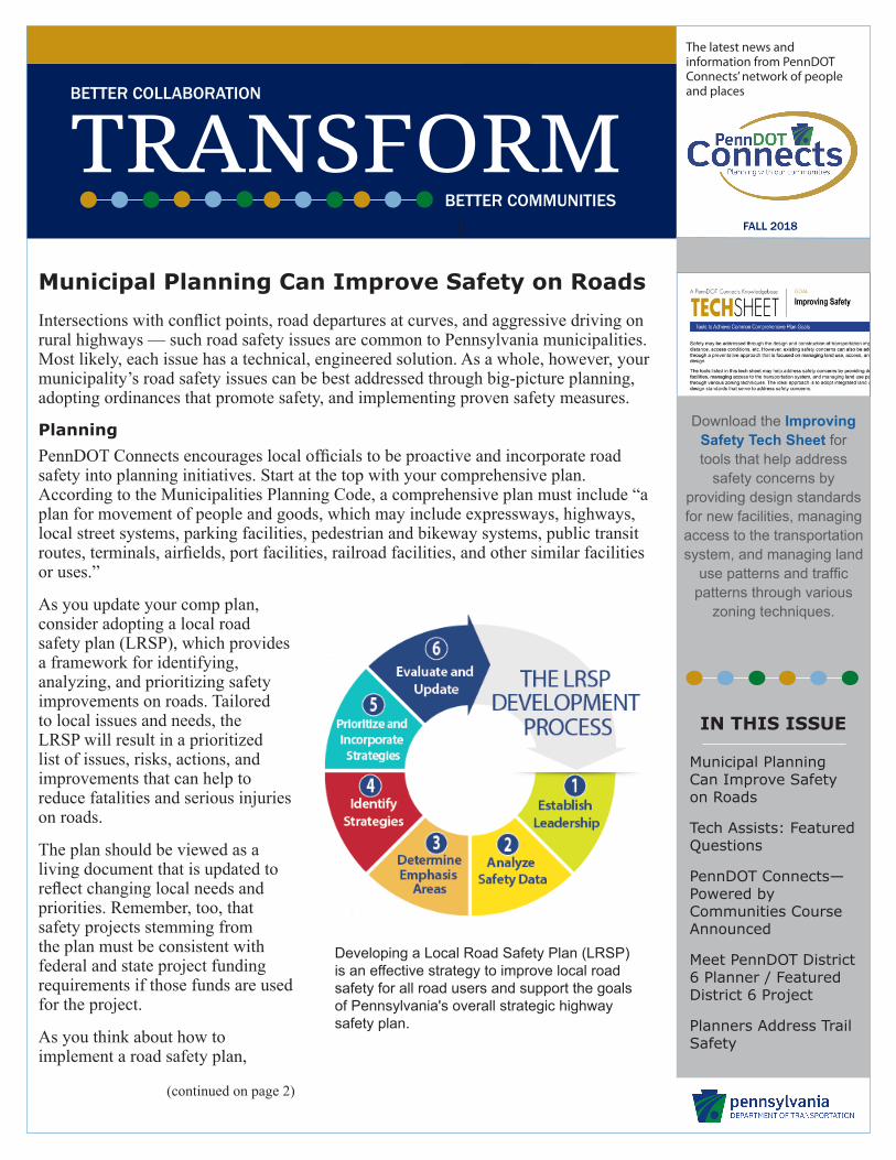
As you update your comp plan, consider adopting a local road safety plan (LRSP), which provides a framework for identifying, analyzing, and prioritizing safety improvements on roads. Tailored to local issues and needs, the LRSP will result in a prioritized list of issues, risks, actions, and improvements that can help to reduce fatalities and serious injuries on roads.
The plan should be viewed as a living document that is updated to reflect changing local needs and priorities. Remember, too, that safety projects stemming from the plan must be consistent with federal and state project funding requirements if those funds are used for the project.
As you think about how to implement a road safety plan,
Developing a Local Road Safety Plan (LRSP) is an effective strategy to improve local road safety for all road users and support the goals of Pennsylvania's overall strategic highway safety plan.
Download the Improving Safety Tech Sheet for tools that help address
safety concerns by providing design standards for new facilities, managing access to the transportation system, and managing land
use patterns and traffic patterns through various
zoning techniques.
The latest news and information from PennDOT Connects’ network of people and places
FALL 2018
2 A PennDOT Connects Resource • For more information, go to paconnects.org. A PennDOT Connects Resource • For more information, go to paconnects.org. 2
(continued from page 1)
Getting Ahead of Safety Issues
PennDOT and its Metropolitan Planning Organization (MPO) and Rural Planning Organization (RPO) partners have a long-standing relationship jointly preparing transportation studies, plans, and programs to make the best possible transportation project investments with available resources.
This strategic alliance is now of even greater importance for implementing PennDOT Connects. Together, the MPO/RPO planning partners and PennDOT can effectively collaborate and communicate with municipalities — and other community stakeholders (e.g., transit operators, economic development agencies, etc.) — to improve transportation system performance and achieve more livable communities.
Municipalities, MPO/RPO planning partners, and PennDOT must collaborate to ensure that opportunities to improve transportation and communities are realized. MPO/RPO contacts can be found at:www.penndot.gov/ProjectAndPrograms/Planning/Pages/MPO-and-RPO-Contact-List.aspx.
collaborate with your MPO/RPO planning partners and PennDOT District planners and consider strategies to enhance road safety in your municipality. Also, ask these planning partners how your safety issues dovetail with PennDOT’s Strategic Highway Safety Plan, which can include local and rural roads as safety emphasis areas.
Strategies & ToolsPerhaps your comprehensive road safety plan calls for more planning to address specific issues, such as the need to develop a bicycle/pedestrian improvement plan. Moving forward, local officials should consider a variety of specific strategies that will meet these goals and improve road safety.
Site Design and Roadway Standards What type of development and roads do your existing ordinances allow? Many current subdivision and land development ordinances (SALDO) are out-of-date and prescribe road designs that actually create unsafe conditions, such as wide neighborhood streets that encourage speeding. Context-sensitive standards can improve safety as well as community character, mobility, and multimodal transportation.
To research options for road standards, consult the following technical resources:
y Pennsylvani Standards for Residential Site Development, Pennsylvania Housing Research Center
y Guidelines for the Design of Local Roads and Streets, Publication 70M (December 2009 Edition), PennDOT
y Pennsylvania’s Traffic Calming Handbook, Publication 383, PennDOT
y Urban Street Design Guide, National Association of City Transportation Officials (available online and for purchase)
y Technical Resources, Institute for Transportation Engineers
Safety Treatments & StrategiesIn 2008, the Federal Highway Administration began promoting certain infrastructure-oriented safety treatments and strategies to reduce serious injuries and fatalities on highways. Known as the Proven Safety Countermeasures, this list has reached a total of 20 treatments and strategies that practitioners can implement to successfully address road departure, intersection, and pedestrian and bicycle crashes. Among these countermeasures are several strategies that cut across multiple safety-focus areas, including road diets, roundabouts, road safety audits, and roadside design improvement at curves. Go to https://safety.fhwa.dot.gov/provencountermeasures for more information.
If you need funding assistance to complete specific planning initiatives, discuss your needs with your MPO/RPO to seek possible support through PennDOT’s dedicated planning study funds.
PennDOT Connects Tech Assist If you need help determining the best approach to improving road safety in your community, you can request technical assistance under PennDOT Connects. Go to paconnects.org. To create a ticket, log into your account. Select the Request Tech Assist button and provide details on the nature of your request.
The latest news and information from PennDOT Connects’ network of people and places
FALL 2018
A PennDOT Connects Resource • For more information, go to paconnects.org. 3
When planning a transportation project, do crosswalks need to be identified and must all crosswalks be painted?Crosswalks are an often misunderstood feature of a road. In Pennsylvania, motorists must yield the right of way to pedestrians in a marked or unmarked crosswalk at non-controlled intersections. Furthermore, legal crosswalks are not required to be painted or lined. It’s important that local officials understand these legal caveats and learn how to enhance crosswalk safety when planning for transportation improvements.
As part of project planning, PennDOT requires project managers to complete a bicycle/pedestrian checklist that includes safety considerations, including whether users would benefit from improved markings at shoulders and crosswalks. Pedestrian attractions, such as schools, parks, commercial establishments, and residential areas, must be accommodated.
Coordination among local officials, PennDOT, and MPO/RPO partners is necessary to determine the need for bicycle and pedestrian facilities in the project area, including crosswalk facilities. Are crosswalk needs identified in a local planning document, regional master plan, or bike/ped plan? Does crash data support the need for new or improved crosswalks? What practices may your municipality adopt to improve cues to motorists, especially at unmarked crosswalks? So know the law and study ways to make all of your municipal crosswalks safer for all.
Interested in using GIS technology but need help getting started? PennDOT Connects Technical Assistance is available to get you started in using Geographic Information System (GIS) technology. Perhaps you have already purchased an ArcGIS Online Account – now what? PennDOT Connects provides technical assistance to help local governments learn what is needed to get started using GIS for planning and management needs. GIS can improve municipal planning, mobile field data collection, and other common workflows, such as inspections and digital asset management.
Getting assistance with GIS is easy. Go to paconnects.org. To create a ticket, log into your account or register your account if you have not yet done so. Select the Request Tech Assist button. A request can be as simple as “What software would you recommend?” or “Where can I find local digital GIS data layers for my municipality?”
A common GIS application might be publishing an online map showing your municipality's important places of interest. Some municipalities are starting to use GIS-based story maps that let you combine the power of maps with narrative text, images and multimedia content to tell a story.
We can lend help with understanding the power of GIS and the use of digital data and mapping to inform planning, analysis, and decision making.
PennDOT Connects Tech Assists: Featured Questions
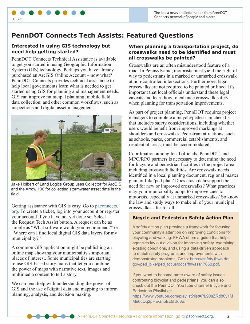
Jake Holbert of Land Logics Group uses Collector for ArcGIS and the Arrow 100 for collecting stormwater asset data in the field.
Bicycle and Pedestrian Safety Action Plan
A safety action plan provides a framework for focusing your community’s attention on improving conditions for bicycling and walking. FHWA offers a guide that helps agencies lay out a vision for improving safety, examining existing conditions, and using a data-driven approach to match safety programs and improvements with demonstrated problems. Go to: https://safety.fhwa.dot.gov/ped_bike/ped_focus/docs/fhwasa17050.pdf.
If you want to become more aware of safety issues confronting bicyclist and pedestrians, you can also check out the PennDOT YouTube channel Bicycle and Pedestrian Playlist at:https://www.youtube.com/playlist?list=PL90uZRd80y1MMe0cQq2pHEGnoEL5fU66u.
The latest news and information from PennDOT Connects’ network of people and places
FALL 2018
4 A PennDOT Connects Resource • For more information, go to paconnects.org.
PennDOT Connects Announces Powered by Communities Course A new course focusing on collaboration opportunities for Pennsylvania municipalities and local transportation stakeholders is now available to maximize engagement in every phase of state transportation projects planning and delivery.
PennDOT Connects—Powered by Communities is designed to build an appreciation for all aspects of planning and engineering that touch transportation projects and to overcome the negative impacts of working in silos. The goal is to deliver better transportation projects that balance community needs with financial and regulatory realities.
“From its inception, PennDOT Connects—Powered by Communities was designed to be a discussion with local officials, PennDOT and regional champions of the PennDOT Connects policy," says James Ritzman, Deputy Secretary for Planning.
The desired outcome is that local officials, PennDOT, and regional planning organizations will identify opportunities to be mutually supportive of each other and to have a greater understanding and appreciation of the need for and the value of staying at the table.
“The most important element of PennDOT Connects is the continuing communication from the inception of an idea through project construction and operation,” says Deputy Secretary for Highway Administration George McAuley.
Municipalities wishing to participate in PennDOT Connects—Powered by Communities should contact their local PennDOT District Planner or Metropolitan/Rural Planning Organization. If you do not have a regional contact, please visit the Support Hub at paconnects.org, call the PennDOT Connects Help Desk at 717-710-2090, or email at [email protected]. You may also request the course through a PennDOT Connects Tech Assist at paconnects.org.
MODULES CONNECT THE DOTS AMONG PLANNING, ENGINEERING, AND CONSTRUCTION
Module 1: The Value of Planning Explain why PennDOT Connects begins with the community.
Explain the benefits of community visioning and proactive approaches to shape the future.
Describe how PennDOT and the MPOs/RPOs can be involved and partner with the community planning process.
Identify how effective planning benefits both transportation and the community.
Module 2: Program Development Explain Program Development in the practical context of transportation planning and programming.
Describe the purpose of the Project Information Form (PIF) and its value.
Identify how problems and opportunities get translated into candidate projects and, ultimately, how they are programmed.
Describe how to be involved in and leverage corridor studies, other transportation studies, and the long-range transportation plans of MPOs and RPOs.
Explain how projects are funded.
Describe the communication process and expectations for project decision-making—with feedback to municipalities.
Explain the purpose of the PennDOT Connects System.
Module 3: Project Delivery Obtain a practical understanding of each phase of project delivery after a project has been programmed—preliminary engineering/NEPA (environmental), final design, construction, maintenance, and operations.
Identify when and how to collaborate through each of the project delivery phases.
Describe the importance of providing feedback as an ongoing activity for both system and project performance, as well as how the community is better because of the improvements made.
Understand that as a project progresses, collaboration opportunities still exist but are fewer, which emphasizes the importance of early collaboration.
“Every community should experience benefits when the PennDOT Connects Policy is followed.” Secretary Leslie Richards
The latest news and information from PennDOT Connects’ network of people and places
FALL 2018
A PennDOT Connects Resource • For more information, go to paconnects.org. 5
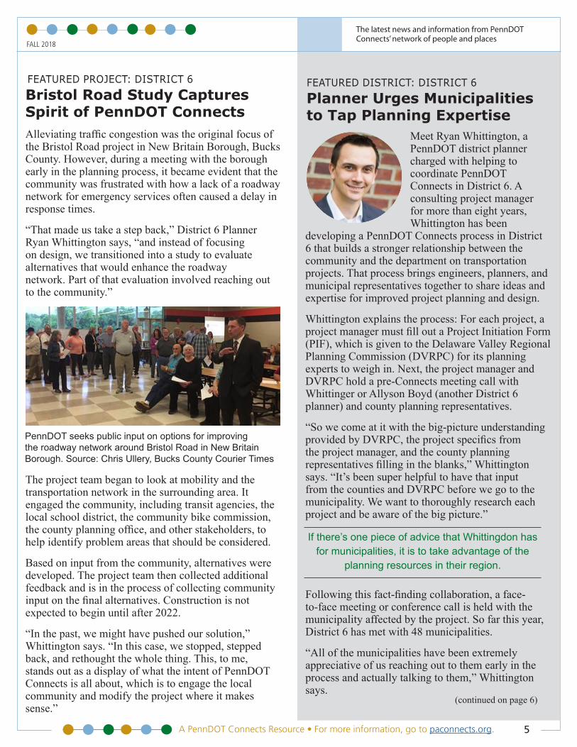
FEATURED PROJECT: DISTRICT 6Bristol Road Study Captures Spirit of PennDOT Connects Alleviating traffic congestion was the original focus of the Bristol Road project in New Britain Borough, Bucks County. However, during a meeting with the borough early in the planning process, it became evident that the community was frustrated with how a lack of a roadway network for emergency services often caused a delay in response times.
“That made us take a step back,” District 6 Planner Ryan Whittington says, “and instead of focusing on design, we transitioned into a study to evaluate alternatives that would enhance the roadway network. Part of that evaluation involved reaching out to the community.”
The project team began to look at mobility and the transportation network in the surrounding area. It engaged the community, including transit agencies, the local school district, the community bike commission, the county planning office, and other stakeholders, to help identify problem areas that should be considered.
Based on input from the community, alternatives were developed. The project team then collected additional feedback and is in the process of collecting community input on the final alternatives. Construction is not expected to begin until after 2022.
“In the past, we might have pushed our solution,” Whittington says. “In this case, we stopped, stepped back, and rethought the whole thing. This, to me, stands out as a display of what the intent of PennDOT Connects is all about, which is to engage the local community and modify the project where it makes sense.”
PennDOT seeks public input on options for improving the roadway network around Bristol Road in New Britain Borough. Source: Chris Ullery, Bucks County Courier Times
FEATURED DISTRICT: DISTRICT 6Planner Urges Municipalities to Tap Planning Expertise
Meet Ryan Whittington, a PennDOT district planner charged with helping to coordinate PennDOT Connects in District 6. A consulting project manager for more than eight years, Whittington has been
developing a PennDOT Connects process in District 6 that builds a stronger relationship between the community and the department on transportation projects. That process brings engineers, planners, and municipal representatives together to share ideas and expertise for improved project planning and design.
Whittington explains the process: For each project, a project manager must fill out a Project Initiation Form (PIF), which is given to the Delaware Valley Regional Planning Commission (DVRPC) for its planning experts to weigh in. Next, the project manager and DVRPC hold a pre-Connects meeting call with Whittinger or Allyson Boyd (another District 6 planner) and county planning representatives.
“So we come at it with the big-picture understanding provided by DVRPC, the project specifics from the project manager, and the county planning representatives filling in the blanks,” Whittington says. “It’s been super helpful to have that input from the counties and DVRPC before we go to the municipality. We want to thoroughly research each project and be aware of the big picture.”
Following this fact-finding collaboration, a face-to-face meeting or conference call is held with the municipality affected by the project. So far this year, District 6 has met with 48 municipalities.
“All of the municipalities have been extremely appreciative of us reaching out to them early in the process and actually talking to them,” Whittington says.
(continued on page 6)
If there’s one piece of advice that Whittingdon has for municipalities, it is to take advantage of the
planning resources in their region.
The latest news and information from PennDOT Connects’ network of people and places
FALL 2018
6 A PennDOT Connects Resource • For more information, go to paconnects.org.
Pennsylvania Department of TransportationWeb: paconnects.org
Email: [email protected]: 717-710-2090
Transportation Planning: Connecting with Community Priorities
Mobility & Efficiency Safety Community Character Project Funding Accommodating GrowthMultimodal Transportation
A PennDOT Connects Resource • For more information, go to paconnects.org. 6
Despite the added work of preparing for these municipal meetings, he believes that the process gathers valuable feedback. It can be as simple as alerting a project manager of an upcoming folk festival and requesting that a local road not be closed down to avoid issues during road construction. Likewise, municipalities often learn of things they were not aware of, such as the existence of a regional bike/ped plan.
“There are two categories of projects that I would say are typical in District 6,” Whittington says.
The first is bridge replacement/roadway reconstruction. For those types of projects, bike/ped enhancements are often an issue. May a road, for instance, be made wider to add a bike lane in the future? Construction timing is another issue. Because congestion is a huge issue in parts of District 6, there is often concern about the impact of a road project on local travel. Or, perhaps a planned state project could be coordinated with another local or county road project that is in the works.
The second category is highly project-specific and involves broader planning studies. (See the District 6 feature project article on page 5 for an example.)
If there’s one piece of advice that Whittington has for municipalities, it is to take advantage of the planning resources in their region.
“I can’t stress that enough,” he says. “Know that there are planning experts out there to help with plans and to answer questions, particularly for municipalities with limited staff.”
For a list of planning contacts in your region, go to: www.penndot.gov/ProjectAndPrograms/Planning/Pages/MPO-and-RPO-Contact-List.aspx.
TECH ASSIST FEATURE
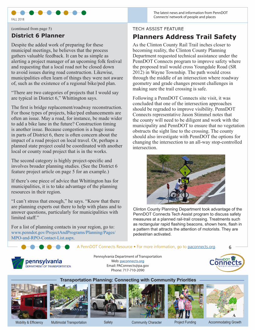
Planners Address Trail SafetyAs the Clinton County Rail Trail inches closer to becoming reality, the Clinton County Planning Department requested technical assistance under the PennDOT Connects program to improve safety where the proposed trail would cross Youngdale Road (SR 2012) in Wayne Township. The path would cross through the middle of an intersection where roadway geometry and grade changes present challenges in making sure the trail crossing is safe.
Following a PennDOT Connects site visit, it was concluded that one of the intersection approaches should be regraded to improve visibility. PennDOT Connects representative Jason Stimmel notes that the county will need to be diligent and work with the municipality and PennDOT to ensure that no vegetation obstructs the sight line to the crossing. The county should also investigate with PennDOT the options for changing the intersection to an all-way stop-controlled intersection.
Clinton County Planning Department took advantage of the PennDOT Connects Tech Assist program to discuss safety measures at a planned rail-trail crossing. Treatments such as rectangular rapid flashing beacons, shown here, flash in a pattern that attracts the attention of motorists. They are pedestrian activated.
(continued from page 5)
District 6 Planner