1
Mauna Kea Kohala Hualālai Kīlauea Mauna Loa East Rift Zone Southwest Rift Zone Kīlauea Caldera Hilo Kailua-Kona Southwest Rift Zone Northeast Mokuʽāweoweo Caldera EXPLANATION Age color blocks indicate lava flows unless noted otherwise ka -thousands of years before present Historic (A.D.) (1790-present) 200-400 400-750 750-1,500 1,500-3,000 3,000-5,000 5,000-10,000 >10,000 (years before present) Kīlauea Mauna Loa Mauna Kea Kohala Hualālai tephra deposit tephra deposit trachyte flow (113-92 ka) Pololū Volcanics (400-250 ka) (230-120 ka) Hawī Volcanics Hāmākua Volcanics (237-81 ka) Younger Member (65-4 ka) Laupāhoehoe Volcanics 0 10 km 0 16 mi Pahala Ash (from Kīlauea and possibly Maun Loa) Sediment Glacial deposit (Mauna Kea) (Mauna Kea/ Kohala) Slope map of Mauna Loa. Warmer colors indicate steeper slopes. Large, bold numbers record the average rates of effusion (outpouring of lava) for the different parts of the Mauna Loa volcano in millions of cubic meters per day (Mm3/d). By comparison, Kïlauea volcano erupts 0.5 Mm 3 /d. Historical lava flows from Mauna Loa are shown in gray, and the numbers along the coastline indicate the approximate time that lava flows took to reach the sea after the vent(s) opened high on the volcano. Map from Frank Trusdell (USGS Hawaiian Volcano Observatory). Map shows the age and distribution of all lava flows on the surface. See map explanation. (data from US Geological Survey) Lava Flows on the Island of Hawaiʽi Kalapana dashed lines are rift zones Rift Zone (25-10 ka) Mauna Loa Pu'u 'Ō'ō Crater Pu'u 'Ō'ō Crater (active 1983-present) vent 1859 flow

1 Lava-flow-map copy - d32ogoqmya1dw8.cloudfront.net · Mauna Kea Kohala Hualālai Mauna Loa Kīlauea East Rift Zone Southwest Rift Zone Kīlauea Caldera Hilo Kailua-Kona Southwest

  • Upload
    buianh

  • View
    214

  • Download
    0

Embed Size (px)

Citation preview

Mauna Kea

Kohala

Hualālai

KīlaueaMauna LoaEast Rift Z

one

Sout

hwes

t Ri

ft Zo

ne

KīlaueaCaldera

Hilo

Kailua-Kona

Sout

hwes

t

Rift

Zone

Northeast

MokuʽāweoweoCaldera

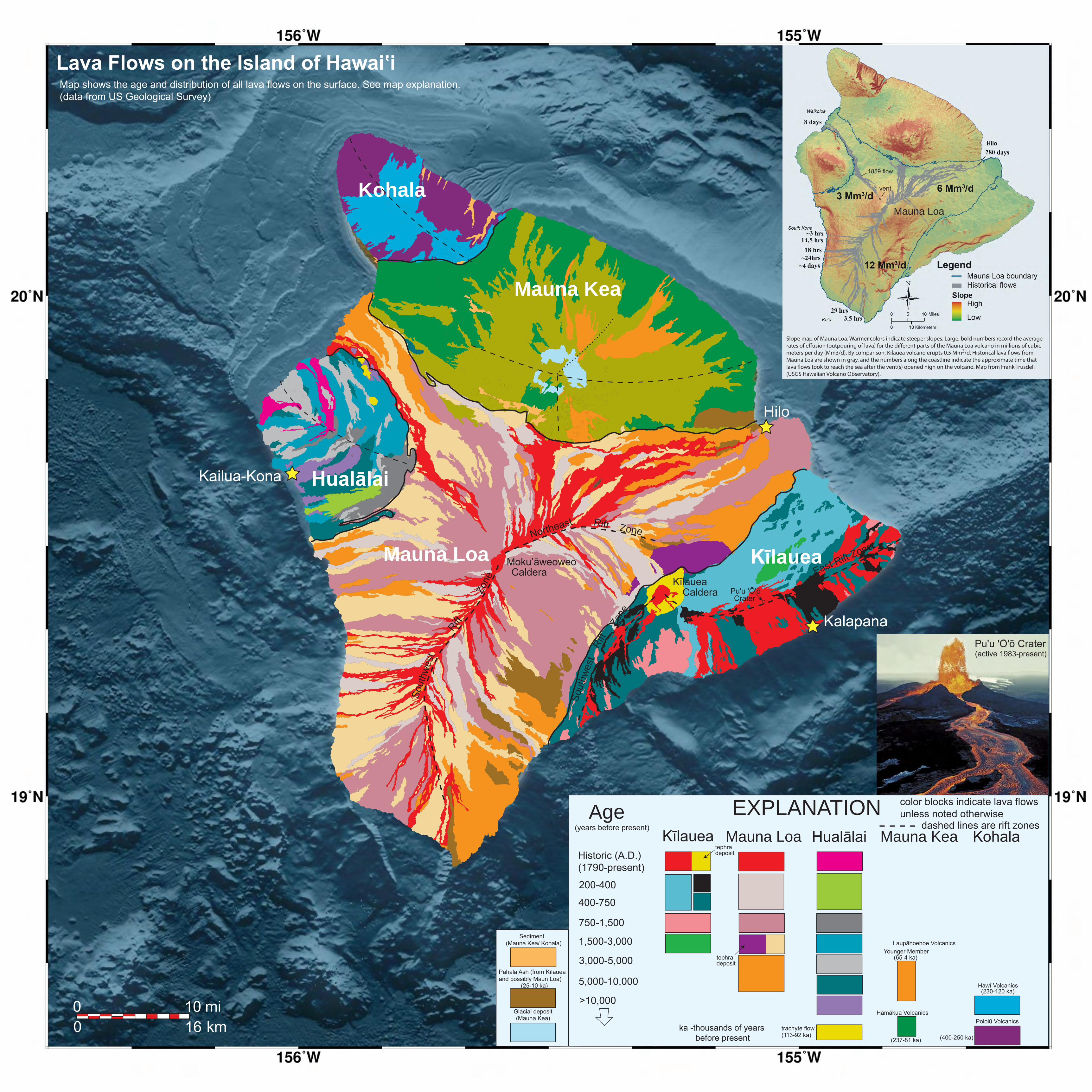
EXPLANATIONAgecolor blocks indicate lava flowsunless noted otherwise

ka -thousands of years before present

Historic (A.D.)(1790-present)

200-400

400-750

750-1,500

1,500-3,000

3,000-5,000

5,000-10,000

>10,000

(years before present)Kīlauea Mauna Loa Mauna Kea KohalaHualālai

tephra deposit

tephra deposit

trachyte flow (113-92 ka)

Pololū Volcanics

(400-250 ka)

(230-120 ka)Hawī Volcanics

Hāmākua Volcanics

(237-81 ka)

Younger Member (65-4 ka)

Laupāhoehoe Volcanics

0 10km0 16mi

Pahala Ash (from Kīlaueaand possibly Maun Loa)

Sediment

Glacial deposit(Mauna Kea)

(Mauna Kea/ Kohala)

Slope map of Mauna Loa. Warmer colors indicate steeper slopes. Large, bold numbers record the average rates of e�usion (outpouring of lava) for the di�erent parts of the Mauna Loa volcano in millions of cubic meters per day (Mm3/d). By comparison, Kïlauea volcano erupts 0.5 Mm3/d. Historical lava �ows from Mauna Loa are shown in gray, and the numbers along the coastline indicate the approximate time that lava �ows took to reach the sea after the vent(s) opened high on the volcano. Map from Frank Trusdell (USGS Hawaiian Volcano Observatory).

Map shows the age and distribution of all lava flows on the surface. See map explanation.(data from US Geological Survey)

Lava Flows on the Island of Hawaiʽi

Kalapana

dashed lines are rift zones

Rift Zone

(25-10 ka)

Mauna Loa

Pu'u 'Ō'ōCrater

Pu'u 'Ō'ō Crater(active 1983-present)

vent

1859 flow