Embed Size (px)
Citation preview
KATH
ERINE
RIVER
KATH
ERINE
RIVER
KA
TH
ER
INE
RIVER
KA
THE
RIN
E
RIV
ER
RailwayStation
KINTORECAVES
Revisions and updates have been made since the initial publicationof this map in May 2007
B
A
F
E
D
C
Mt Thomas
Neds Knob
Prospect Hill
Mt BriggsMt Muriel
Mt Pleasant Plateau Pt
Mt Freda
Mt Armstrong
Limestone Hill
Mt Pearce
Mt Compton
Crocker Hill
Mt Bowman
Mullens Ridge
Dead Horse Hill
Gallery Hill
Bondi Ridge
Beasley Pillar
Mt Todd
Zed Hill
Foelsche Headland
Far View Peak
Mt Mueller
Mt Colton
RomulaKnob
TinkerHill
Leliyn(Edith Falls)
Cave
Creek
ROPER
RIVER
Creek
Else
y
Cre
ek
Cat
tle
Maryfield
Creek
STR
AN
GW
AYS
RIVE
R
Birdum
Creek
Cre
ek
Sund
ay
Western
Cre
ek
Cow
Creek
Creek
Mid
dle
West
ern
Creek
Besw
ick
CreekCreek
Roper
Maranboy
Creek
RIV
ER
KIN
G
RIV
ER
KATHERINE
KATHERINE RIVERKING
RIVER
Limestone
Creek
Scott
Creek
Mathison
Creek
DRY
RIVE
R
DRY
RIVE
R
Cre
ek
Battle
REYNOLD
S
RIVER
Hay
war
d
Cre
ek
Ant
Gre
en
DOUGLAS
RIVER
SandyC
reek
Dep
ot
Creek
Middle Creek
Gyp
syC
reek
Austral
Creek
Cre
ek
Cre
ek
Snap
e
Surv
ey
DAL
Y RIVER
DA
LY
RIVER
RIVER
DALY
Dea
dH
orse
Ck
Stray
Creek
Cat
tleC
reek
Jind
ucki
nC
reek
RIV
ER
FIS
H
Lilyarba
Creek
Camp CkSalt
Trough
Ck
Copperfield
Ck
FERGUSSON
RIVER
Eight
MileCk
Driffield Creek
Stow
Creek
EDITHRIVER
Granite
CkYujullowan
RIVER
FLORA
Native Cat
Ck
Creek
Bra
dsha
w
Bam
boo
(Mo
on B
oo
n)
Creek
Hay
esC
k
FERGUSSON
RIVER
Ck
Ck
DALY
FLORA
DR
Y
CU
LLE
N
RIVER
EDITH
RIVER
RIV
ER
STR
AN
GW
AYS
KING
RIVER
KATHERINE
RIVER
RIV
ER
R.
R.
RIVERFERGUSSON
DALY
FLORA
DR
Y
CU
LLE
N
RIVER
EDITH
RIVER
RIV
ER
STR
AN
GW
AYS
KING
RIVER
KATHERINE
RIVER
RIV
ER
R.
R.
RIVERFERGUSSON
DALY
FLORA
CU
LLE
N
EDITH
RIVER
KING
RIV
ER
RIVER
RIVER
R
FERGUSSON
RIVER
DALY
RIVER
RIVER
RIVER
DOUGLAS
KATHERINE
Oolloo Springs
Rainbow Spring
Fig TreeSpring
Bitter Springs (See note 3)
DouglasHot Springs(See note 1)
FloraRiver
Spring
(see note 2)
KatherineHot
Springs
2200622006
2942929429
75957595
2171721717
RN22397RN22397
Delamere RangeFacil i ty
Mataranka
BamyiliKATHERINE
Dunmarra
Larrimah
DalyWaters
PineCreek
TopSprings
Daly Waters
Mataranka
BamyiliKATHERINE
Larrimah
PineCreek
Daly Waters
Mataranka
BamyiliKATHERINE
Larrimah
PineCreek
HayesCreek
MargaretDowns
Tipperary
Dorisvale
Douglas
Claravale
Delamere
Florina
Jindare
Maranboy
Kalala
Maryfield
Tarlee
Gorrie
Nenen
Wyworrie
Blood Downs
Birdum Creek
Maryfield(ruins)
WesternCreek
SundayCreek
Fergusson River
Scott Creek Mataranka Homestead
Middle Creek
Dry River
LewinSprings
Banatjarl
Werenbun
Jodetluk
Dillinya
Douglas DalyExperimental
Station
Djarrung
BishopsBore
Jomet(Urpalarwn)
Binjari
Jilkminggan
Daly Waters
Pine Creek
Larrimah
Kybrook Farm
Mataranka
Rockhole
Nauiyu
Barunga
Katherine
KATHERINE
KATHERINE
Douglas Crossing
Oolloo Crossing
BeeboomCrossing
ROPER HIGHWAY
Daly River
Road
Cade
ll
Fleming
Road
Oollo
o
Dorat
Road
Rd
Rd
Centra
l
Road
Arnhem
BUNTINE
HIG
HW
AY
HWY
STUART
Gorge
Road
Florina
Road
HWY.
VICTORIA
STUA
RT
HIG
HW
AY
VICTORIA
HIGH
WAY STUART
HIGHWAYSTU
ART
HIG
HW
AY
STUART
HIGHW
AY
HIGHW
AY
BUCHANAN
BUN
TINE
HW
Y
HWY
CARPENTARIA
STUART
HIG
HW
AY
HWY
VICT
ORIA
BUN
TINE
HW
Y
STUART
HIG
HW
AY
HWY.
VICT
ORIA
HIGHW
AY
BUN
TINE
HW
Y
CARPENTARIA
STUART
HIG
HW
AY
HWY
VICT
ORIA
HIGHWAY
STUART
VICTO
RIA
HWY
AVAGO
TARLEEWESTERN CK
GILNOCKIE
GORRIE
LARRIZONA
NENEN
DRY RIVER
MANBULLOO
INNESVALE
DORISVALE
TIPPERARY
FLORINA
CLARAVALE
JINDARE
BONROOK
DOUGLAS
KALALA
MARYFIELD
VERMELHA
BIRDUM CKMIDDLE CK
COW CREEK
WYWORRIE
LAKEFIELDELSEY
EAST MATHISON
SCOTT CREEK
WESTMATHISON
MARYRIVERWEST
BLOODWOODDOWNS
SUNDAYCREEK
MARGARETDOWNS
ELSEY
FLORARIVER
LITCHFIELD
DALY RIVER(Mt. Nancar)
TJUWALIYN
UMBRAWARRAGORGE
STRAYCREEK
DOUGLAS RIVER/ DALY RIVER
NITMILUK(Katherine
Gorge)
STRAYCREEK
90
8070
60
50
6070
80
90
100
110
100
100
120
130
140
150
160
170
130
130
140
140
100
60
50
4030
70
8090
110
60
50
20
DALY BASIN
WISOBASIN
GE
OR
GIN
AB
ASIN
STUA
RT
HW
Y.
HWY.ROPER
Creek
Elsey
ROPERRIVERMataranka
RIVER
KATHERINE
KATHERINE HWY.
STUART
VICTORIA
HWY.
FLORA
Mathison
R I V E R
RIVERDOUGLAS
Ck.
Haye
s
DALY
RIVER
BambooCreek
Ck
BitterSprings Rainbow
Spring
DALYBASIN
GEORGINABASIN
WISO BASIN
100 -100
100
150
100
-100
0
50
50
0
150
100 50
0
-200-300
-400
-500
-600
-400
0-100
-200-300
-400-500
-600
-300
-200 -100 0
50
100
50
100
50
-300
DA
LY
RIV
ER
RO
PE
R
RIVER
DA
LY
RIVER
VIC
TO
RIA
RIVER
DALYRIVER
ADELAIDERIVER
FINNISS RIVER
G8140411G8140411G8140001G8140001
G8140410G8140410G8140409G8140409
G8140312G8140312G8140408G8140408
G8140222G8140222G8140407G8140407
G8140535G8140535
G8140003G8140003
G8140008G8140008G8140038G8140038
G8140040G8140040 G8140042G8140042
G8140044G8140044
G8140060G8140060
G8140063G8140063
G8140067G8140067
G8140098G8140098
G8140157G8140157
G8140161G8140161
G8140169G8140169
G8140205G8140205
G8140538G8140538
G8170008G8170008
G8140011G8140011
G8140022G8140022
G8140025G8140025
G8140068G8140068
G8140086G8140086
G8140152G8140152
G8140158G8140158
G8140536G8140536
G9030001G9030001
G9030176G9030176
G8140159G8140159
750000mE
200000mE
300000mE
700000mE
8500
000m
N
8250
000m
N
200000mE 300000mE
8350000mN
800000mE
8300
000m
N
700000mE
8400000mN
750000mE
8450000mN
8500000mN
800000mE
8450000mN
8400000mN
250000mE
8250
000m
N
350000mE250000mE
8300
000m
N
8450000mN
200000mE
8300000mN
8400000mN
8500000mN
8200
000m
N83
0000
0mN
8400
000m
N
200000mE 300000mE 400000mE
8200000mN
8500
000m
N
200000mE 300000mE 400000mE
200000mE 300000mE 400000mE
8200
000m
N
8200
000m
N85
0000
0mN
700000mE
8300
000m
N84
0000
0mN
8500
000m
N
8300
000m
N84
0000
0mN
200000mE 300000mE 400000mE 500000mE
500000mE
200000mE 300000mE
8200
000m
N
8200
000m
N85
0000
0mN
300000mE200000mE
8300
000m
N84
0000
0mN
8500
000m
N
8400
000m
N83
0000
0mN
200000mE
8500
000m
N
700000mE
200000mE
8500
000m
N
8400
000m
N
8400
000m
N
800000mE700000mE
800000mE700000mE
Zone 52 Zone 53
800000mE
Zone 52 Zone 53
800000mE700000mE
8450
000m
N
8450
000m
N
Zone 52 Zone 53
750000mE 800000mE
800000mE700000mE 750000mE
700000mE 800000mE
800000mE700000mE
Zone 52 Zone 53
MGA Zone 53MGA Zone 52
200000mE195000mE 205000mE 210000mE
200000mE195000mE 205000mE 210000mE
8395
000m
N84
0000
0mN
8405
000m
N
8395
000m
N84
0000
0mN
8405
000m
N
Tindall Water Level TindallWater Level
Cretaceous Sand/Clay CretaceousSand/Clay Cretaceous
Sand/Clay
TindallLimestone
Tindall Water Level
Tindall Water Level
JinduckinWater Level
CretacousSand/Clay
Cretacous Sand/Clay
Oolloo Water Level
Oolloo Water Level
DISTANCE (kilometres)0 50
0
400
-600
-400
E F
Fau
lt
BasaltBasalt
Basalt
200
-200
0
400
-400
200
-200
-600
SECTION E - F
EL
EV
AT
ION
(m
etr
es
AH
D)
TindallLimestone
100
SandstoneJinduckinFormation
TindallLimestone
Ro
per
Ck.
Rai
nbo
w S
p.
Wat
erh
ou
se R
.
150
JinduckinWater Level
0
Fau
lt
Dal
y R
iver
(maj
or
spri
ngs)
Fau
lt
RN
336
16(p
roje
cted
)SECTION A - B
DISTANCE (kilometres) 50
0
400
-400
200
-200
-800
EL
EV
AT
ION
(m
etr
es
AH
D)
-400
DA
TindallLimestone
TindallLimestone
Siltstone / Sandstone / Granite
Siltstone/
Sandstone / Granite
Jinduckin Formation
0
400
-400
200
-200
-800
-400
Oolloo Dolostone
DISTANCE (kilometres)0 50
C
0
400
-400
200
-200
-800
SECTION C - D
EL
EV
AT
ION
(m
etr
es
AH
D)
-400
0
400
-400
200
-200
-800
-400
100
D
Dal
y R
iver
Cretacous Sand/Clay
Cretacous Sand/Clay
Florina Formation
Oolloo Dolostone"Massive Unit"
Tindall
L imestone
Basalt
BasaltJ induck in
Formation
TindallWater Level
TindallWater Level
OollooDolostone
This product and all material forming part of it is copyright belonging to the Northern Territory of Australia. You may use this material foryour personal, non-commercial use or use it within your organisation for non-commercial purposes, provided that an appropriateacknowledgement is made and the material is not altered in any way. Subject to the fair dealing provisions of the Copyright Act 1968, youmust not make any other use of this product (including copying or reproducing it or part of it in any way) unless you have the writtenpermission of the Northern Territory of Australia to do so.The Northern Territory of Australia does not warrant that the product or any part of it is correct or complete and will not be liable for anyloss damage or injury suffered by any person as a result of its inaccuracy or incompleteness.
C Northern Territory of Australia
This map was producedon the Geocentric Datum
of Australia 1994 (GDA 94)
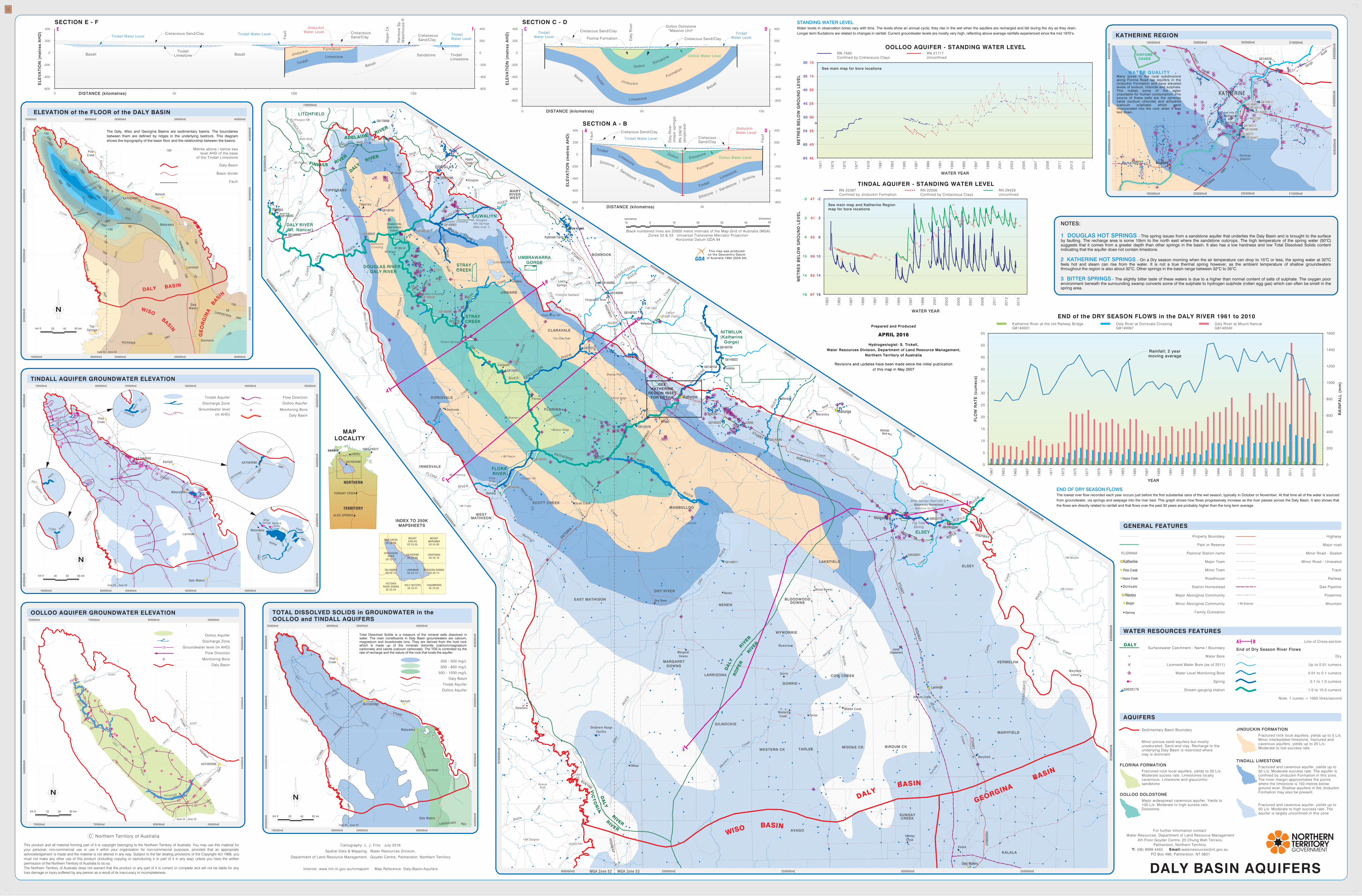
The Daly, Wiso and Georgina Basins are sedimentary basins. The boundariesbetween them are defined by ridges in the underlying bedrock. This diagramshows the topography of the basin floor and the relationship between the basins.
Total Dissolved Solids is a measure of the mineral salts dissolved inwater. The main constituents in Daly Basin groundwaters are calcium,magnesium and bicarbonate ions. They are derived from the host rockwhich is made up of the minerals dolomite (calcium/magnesiumcarbonate) and calcite (calcium carbonate). The TDS is controlled by therate of recharge and the nature of the rock that hosts the aquifer.
STANDING WATER LEVELWater levels in observation bores vary with time. The levels show an annual cycle; they rise in the wet when the aquifers are recharged and fall during the dry as they drain.Longer term fluctations are related to changes in rainfall. Current groundwater levels are mostly very high, reflecting above average rainfalls experienced since the mid 1970’s.
W A T E R Q U A L I T YMany bores in the rural subdivisionsalong Florina Road tap aquifers in theJinduckin Formation and have elevatedlevels of sodium, chloride and sulphate.This makes some of the waterunsuitable for human consumption. Thesource of these salts are the mineralshalite (sodium chloride) and anhydrite(calicum sulphate) which wereincorporated into the rock when it waslaid down.
NOTES:
1 DOUGLAS HOT SPRINGS - This spring issues from a sandstone aquifer that underlies the Daly Basin and is brought to the surfaceby faulting. The recharge area is some 15km to the north east where the sandstone outcrops. The high temperature of the spring water (50^C)suggests that it comes from a greater depth than other springs in the basin. It also has a low hardness and low Total Dissolved Solids contentindicating that the aquifer does not contain limestone.
2 KATHERINE HOT SPRINGS - On a Dry season morning when the air temperature can drop to 15^C or less, the spring water at 32?Cfeels hot and steam can rise from the water. It is not a true thermal spring however, as the ambient temperature of shallow groundwatersthroughout the region is also about 32^C. Other springs in the basin range between 32^C to 35^C.
3 BITTER SPRINGS - The slightly bitter taste of these waters is due to a higher than normal content of salts of sulphate. The oxygen poorenvironment beneath the surrounding swamp converts some of the sulphate to hydrogen sulphide (rotten egg gas) which can often be smelt in thespring area.
Black numbered lines are 20000 metre intervals of the Map Grid of Australia (MGA)Zones 52 & 53 Universal Transverse Mercator Projection
Horizontal Datum GDA 94
0 10 20 30 40
kilometres50
kilometres10
END OF DRY SEASON FLOWSThe lowest river flow recorded each year occurs just before the first substantial rains of the wet season, typically in October or November. At that time all of the water is sourcedfrom groundwater, via springs and seepage into the river bed. This graph shows how flows progressively increase as the river passes across the Daly Basin. It also shows thatthe flows are directly related to rainfall and that flows over the past 30 years are probably higher than the long term average.
For further information contact:Water Resources, Department of Land Resource Management
4th Floor Goyder Centre, 25 Chung Wah Terrace,Palmerston, Northern Territory.
T: (08) 8999 4455 Email: [email protected] Box 496, Palmerston, NT 0831
Water Bore
Water Level Monitoring Bore
Stream gauging station
Spring
Line of Cross-section
End of Dry Season River Flows
Dry
0.01 to 0.1 cumecs
0.1 to 1.0 cumecs
1.0 to 10.0 cumecs
BASurfacewater Catchment - Name / Boundary
G9030176
DALY BASIN AQUIFERS
FLORINA FORMATIONFractured rock local aquifers, yields to 20 L/s.Moderate sucess rate. Limestones locallycavernous. Limestone and glauconiticsandstone
OOLLOO DOLOSTONE
Fractured and cavenous aquifer, yields up to50 L/s. Moderate success rate. The aquifer isconfined by Jinduckin Formation in this zone.The inner margin approximates the pointswhere the limestone is 150 metres belowground level. Shallow aquifers in the JinduckinFormation may also be present.
Fractured and cavenous aquifer, yields up to50 L/s. Moderate to high success rate. Theaquifer is largely unconfined in this zone
Fractured rock local aquifers, yields up to 5 L/s.Minor interbedded limestone, fractured andcavenous aquifers, yields up to 20 L/s.Moderate to low success rate.
JINDUCKIN FORMATION
TINDALL LIMESTONE
Up to 0.01 cumecs
AQUIFERS
WATER RESOURCES FEATURES
Railway
Gas Pipeline
Property Boundary
Station Homestead
Powerline
MountainMt Bowman
Park or Reserve
GENERAL FEATURES
Major Aboriginal Community
Minor Aboriginal Community
Major Town
Minor Town
Roadhouse
Highway
Major road
Track
Family Outstation
Minor Road - Sealed
Minor Road - Unsealed
ELEVATION of the FLOOR of the DALY BASIN
20 60 kmkm 0 40
100 Metres above / below sealevel AHD of the base
of the Tindall Limestone
20 60 kmkm 0 40
TINDALL AQUIFER GROUNDWATER ELEVATION
Daly Basin
Flow DirectionTindall Aquifer
Discharge Zone
Monitoring Bore
Oolloo Aquifer
Groundwater level(m AHD)110
OOLLOO AQUIFER GROUNDWATER ELEVATION TOTAL DISSOLVED SOLIDS in GROUNDWATER in theOOLLOO and TINDALL AQUIFERS
200 - 500 mg/L
500 - 800 mg/L
500 - 1500 mg/L
Daly Basin
Note: 1 cumec = 1000 litres/second
Fault
Daly Basin
Basin divide
70
Daly Basin
Flow Direction
Discharge Zone
Monitoring Bore
Oolloo Aquifer
Groundwater level (m AHD)
KATHERINE
NHULUNBUY
JABIRUDARWIN
NORTHERN
TERRITORY
TENNANT CREEK
ALICE SPRINGS
PINE CREEKSD 52-08
MOUNTEVELYN
SD 53-05
MOUNTMARUMBASD 53-06
FERGUSSONRIVER
SD 52-12
KATHERINESD 53-09
URAPUNGASD 53-10
DELAMERESD 52-16
LARRIMAHSD 53-13
HODGSON DOWNSSD 53-14
VICTORIARIVER DOWNS
SE 52-04
DALY WATERSSE 53-01
TANUMBIRINISE 53-02
MAPLOCALITY
Pastoral Station nameFLORINA
Hayes Creek
Dorisvale
Katherine
Pine Creek
Nauiyu
Binjari
Djarrung
INDEX TO 250KMAPSHEETS
10 30 kmkm 0 20
20 60 kmkm 0 40
DALY
SEEKATHERINE
REGION INSETFOR DETAIL
Minor porous sand aquifers but mostlyunsaturated. Sand and clay. Recharge to theunderlying Daly Basin is restricted whereclay is dominant.
Licensed Water Bore (as of 2011)
Oolloo Aquifer
Tindal Aquifer
KATHERINE REGION
2013
2015
1971
1973
1975
1977
1979
WATER YEAR
1981
1983
1985
1987
1989
1991
1993
1995
1997
1999
2001
2003
2005
ME
TR
ES
BE
LO
W G
RO
UN
D L
EV
EL
65
60
55
50
45
40
2007
2009
2011
RN 7595Confined by Cretaceuos Clays
OOLLOO AQUIFER - STANDING WATER LEVELRN 21717Unconfined
See main map for bore locations
35
30
45
40
35
30
25
20
15
10
1983
1985
1987
1989
1991
1993
1995
1997
1999
2001
2003
2005
ME
TR
ES
BE
LO
W G
RO
UN
D L
EV
EL
67
63
59
55
51
47
18
14
10
6
2
-2
18
14
10
6
2
-2
2007
2009
2011
WATER YEAR
TINDAL AQUIFER - STANDING WATER LEVELRN 29429Unconfined
See main map and Katherine Regionmap for bore locations
2013
2015
RN 22006Confined by Cretaceous Clays
RN 22397Confined by Jinduckin Formation
1961
1963
1965
1967
1969
1971
1973
1975
1977
1979
1981
1983
1985
1987
1989
1991
1993
1995
1997
1999
2001
2003
2005
FL
OW
RA
TE
(cu
me
cs)
0
5
10
15
20
25
30
35
0
200
400
600
1000
1200
1400
1600
Rainfall; 2 yearmoving average
2007
800
YEAR
2009
2011
Daly River at Mount NancarG8140040
Daly River at Dorisvale CrossingG8140067
Katherine River at the old Railway BridgeG8140001
END of the DRY SEASON FLOWS in the DALY RIVER 1961 to 2010
2013
2015
40
45
50
55
RA
INF
AL
L (
mm
)
Sedimentary Basin Boundary
Prepared and ProducedPrepared and Produced
APRIL 2016APRIL 2016
Hydrogeologist: S. Tickell,Water Resources Division, Department of Land Resource Management,
Northern Territory of Australia
Hydrogeologist: S. Tickell,Water Resources Division, Department of Land Resource Management,
Northern Territory of Australia
Revisions and updates have been made since the initial publicationof this map in May 2007
Revisions and updates have been made since the initial publicationof this map in May 2007
Major widespread cavernous aquifer. Yields to100 L/s. Moderate to high sucess rate.Dolostone.
Cartography: L. J. Fritz July 2016
Spatial Data & Mapping, Water Resources Division,
Department of Land Resource Management, Goyder Centre, Palmerston, Northern Territory
Internet: www.lrm.nt.gov.au/nrmapsnt Map Reference: Daly-Basin-Aquifers