Embed Size (px)
Citation preview
This document was downloaded on June 20, 2015 at 18:47:15
Author(s) Schwent, John T.; Barge, Hezekiah
Title Field level information collaboration during complex humanitarian emergencies andpeace operations
Publisher Monterey, California. Naval Postgraduate School
Issue Date 2003-06
URL http://hdl.handle.net/10945/1031
NAVAL POSTGRADUATE SCHOOL Monterey, California
THESIS FIELD LEVEL INFORMATION COLLABORATION DURING COMPLEX HUMANITARIAN EMERGENCIES AND PEACE
OPERATIONS
by
Hezekiah Barge, Jr. Mark S. Davis
John T. Schwent, Jr.
June 2003
Co-Advisors: Alex Bordetsky Glenn Cook
Approved for public release; distribution is unlimited
THIS PAGE INTENTIONALLY LEFT BLANK
REPORT DOCUMENTATION PAGE Form Approved OMB No. 0704-0188
Public reporting burden for this collection of information is estimated to average 1 hour per response, including the time for reviewing instruction, searching existing data sources, gathering and maintaining the data needed, and completing and reviewing the collection of information. Send comments regarding this burden estimate or any other aspect of this collection of information, including suggestions for reducing this burden, to Washington headquarters Services, Directorate for Information Operations and Reports, 1215 Jefferson Davis Highway, Suite 1204, Arlington, VA 22202-4302, and to the Office of Management and Budget, Paperwork Reduction Project (0704-0188) Washington DC 20503. 1. AGENCY USE ONLY (Leave blank)
2. REPORT DATE June 2003
3. REPORT TYPE AND DATES COVERED Master’s Thesis
4. TITLE AND SUBTITLE Field Level Information Collaboration During Complex Humanitarian Emergencies and Peace Operations.
5. FUNDING NUMBERS
6. AUTHOR (S) Hezekiah Barge, Jr., Mark S. Davis, John T. Schwent, Jr.
7. PERFORMING ORGANIZATION NAME(S) AND ADDRESS(ES) Naval Postgraduate School Monterey, CA 93943-5000
8. PERFORMING ORGANIZATION REPORT NUMBER
9. SPONSORING / MONITORING AGENCY NAME(S) AND ADDRESS(ES) 10. SPONSORING/MONITORING AGENCY REPORT NUMBER
11. SUPPLEMENTARY NOTES The views expressed in this thesis are those of the authors and do not reflect the official policy or position of the U.S. Department of Defense or the U.S. Government.
12a. DISTRIBUTION / AVAILABILITY STATEMENT Approved for public release; distribution is unlimited
12b. DISTRIBUTION CODE
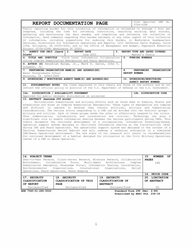
13. ABSTRACT (maximum 200 words) Multinational humanitarian and military efforts such as those seen in Somalia, Kosovo and
Afghanistan are known as Complex Humanitarian Emergencies. These types of emergencies are complex and difficult to operate in because they contain political, military and humanitarian considerations. The various actors responding to a CHE can be divided into two distinct groups – military and civilian. Each of these groups needs the other to effectively respond to the crisis. Thus communication, collaboration and coordination are critical. Technology can play a significant role to enable information sharing between the various participants during CHEs. This thesis documents the continued development of a collaborative, Information Technology-based, operation support system designed to facilitate information sharing at the field/tactical level during CHE and Peace Operations. The operational support system was designed in the context of a Tactical Humanitarian Relief Habitat and will undergo a technical evaluation in a simulated CHE/Peace Operations environment. The end state of our research will result in recommendations for continued development of a habitat designed for utilization in the Civil Military Operations enter of a CHE or Peace Operation. C
14. SUBJECT TERMS Peer-to-Peer Network, Client-Server Network, Wireless Network, Collaborative Environment, Collaborative Tools, Multi-Agent Architecture, Complex Humanitarian Emergency, Knowledge Portal, Information Sharing, Coordination, Non-Governmental Organizations, International Organizations, Relief Operations, Peace Operations, Peace Keeping
15. NUMBER OFPAGES
185
16. PRICE CODE 17. SECURITY CLASSIFICATION OF REPORT
Unclassified
18. SECURITY CLASSIFICATION OF THIS PAGE
Unclassified
19. SECURITY CLASSIFICATION OF ABSTRACT
Unclassified
20. LIMITATION OF ABSTRACT
UL NSN 7540-01-280-5500 Standard Form 298 (Rev. 2-89) Prescribed by ANSI Std. 239-18
i
THIS PAGE INTENTIONALLY LEFT BLANK
ii
Approved for public release; distribution is unlimited
FIELD LEVEL INFORMATION COLLABORATION DURING COMPLEX HUMANITARIAN EMERGENCIES AND PEACE OPERATIONS
Hezekiah Barge, Jr.
Major, United States Marine Corps B.S., Florida A&M University, 1991
Mark S. Davis
Captain, United States Marine Corps B.A., University of California San Diego, 1995
John T. Schwent, Jr.
Captain, United States Marine Corps B.A., University of Memphis, 1996 M.B.A., Webster University, 2001
Submitted in partial fulfillment of the
requirements for the degree of
MASTER OF SCIENCE IN INFORMATION TECHNOLOGY MANAGEMENT
from the
NAVAL POSTGRADUATE SCHOOL June 2003
Authors: Hezekiah Barge, Jr.
Mark S. Davis
John T. Schwent, Jr. Approved by: Alex Bordetsky Thesis Co-Advisor
Glenn Cook Thesis Co-Advisor
Dan C. Boger
iii
Chairman, Department of Information Sciences
THIS PAGE INTENTIONALLY LEFT BLANK
iv
ABSTRACT
Multinational humanitarian and military efforts such
as those seen in Somalia, Kosovo and Afghanistan are known
as Complex Humanitarian Emergencies. These types of
emergencies are complex and difficult to operate in because
they contain political, military and humanitarian
considerations. The various actors responding to a CHE can
be divided into two distinct groups – military and
civilian. Each of these groups needs the other to
effectively respond to the crisis. Thus communication,
collaboration and coordination are critical. Technology can
play a significant role to enable information sharing
between the various participants during CHEs. This thesis
documents the continued development of a collaborative,
Information Technology-based, operation support system
designed to facilitate information sharing at the
field/tactical level during CHE and Peace Operations. The
operational support system was designed in the context of a
Tactical Humanitarian Relief Habitat and will undergo a
technical evaluation in a simulated CHE/Peace Operations
environment. The end state of our research will result in
recommendations for continued development of the habitat
designed to be utilized in the Civil Military Operations
Center of a CHE or Peace Operation.
v

THIS PAGE INTENTIONALLY LEFT BLANK
vi
TABLE OF CONTENTS
I. INTRODUCTION ............................................1 A. AREA OF RESEARCH ...................................1 B. BACKGROUND .........................................1 C. THESIS FOCUS .......................................3 D. STATEMENT OF PROBLEM ...............................4
1. Failing to Share Information ..................5 2. Organizational and Cultural Divide ............6 3. Language Barriers ............................10 4. Competing Priorities and Perceptions .........11 5. Professional and Cultural Norms ..............12 6. Lack of Trust and Stereotypes ................13
E. METHODOLOGY .......................................14 F. ORGANIZATION ......................................15
II. RELATED WORKS ..........................................17 A. INTRODUCTION ......................................17 B. ORGANIZATIONAL SOLUTIONS: MILITARY ................17
1. The Humanitarian Assistance Coordination Center (HACC) ................................17
2. The Humanitarian Operations Center (HOC) .....18 3. The Civil Military Operations Center (CMOC) ..19 4. NATO Civil-Military Cooperation Centers
(CIMIC) ......................................22 C. ORGANIZATIONAL SOLUTIONS: UN PERSPECTIVE ..........24
1. On-Site Operations Coordination Center (OSOCC) ......................................24
2. Humanitarian (Community) Information Center (CIC/HIC) ....................................25
D. TECHNOLOGY SOLUTIONS: OVERVIEW ....................26 E. TECHNOLOGY INITIATIVES: MILITARY ..................28
1. The CIMILink Project .........................28 a. Background ..............................28 b. Functionality ...........................30
2. NEO Tracking System 2000 .....................32 a. Background ..............................32 b. Functionality ...........................33
3. Virtual Information Center (VIC) .............36 a. Background ..............................36 b. Functionality ...........................37
4. The Peace Operations Support Tool (POST) .....39 a. Background ..............................39 b. Functionality ...........................40
vii
F. TECHNOLOGY SOLUTIONS: CIVILIAN ....................42 1. Relief Web ...................................42
a. Background ..............................42 b. Functionality ...........................44
2. Collaborative Techniques for Coalition Teams (CT2) ........................................47 a. Background ..............................47 b. Functionality ...........................47
3. The Virtual Operations Coordination Center – VOCC .........................................49 a. Background ..............................49 b. Functionality ...........................51
G. SUMMARY ...........................................52 III. METHODOLOGY ............................................53
A. INTRODUCTION ......................................53 B. REQUIREMENTS ......................................53 C. INFORMATION REQUIREMENTS ..........................54
1. Conference on Information Sharing ............54 2. Interviews from Bosnia .......................55
a. Problem Statement .......................56 b. Information Requirements ................56 c. Technical Issues ........................58
D. SYSTEM REQUIREMENTS ...............................59 E. MODEL DEVELOPMENT .................................62
1. Technological Subsystem ......................63 2. Social/Political Subsystem ...................63 3. Structural Subsystem .........................64 4. Goals and Values Subsystem ...................64 5. Leadership & Management Subsystem ............64
F. PARTNERSHIP DEVELOPMENT ...........................64 IV. ENVIRONMENT ............................................67
A. INTRODUCTION ......................................67 B. DEFINITION ........................................67 C. ORGANIZATIONAL INVOLVEMENT ........................68 D. DIFFERING GOALS ...................................69 E. ORGANIZATIONAL STRUCTURES AND CULTURES ............71
1. Military .....................................71 2. International Organizations (IO) .............72 3. Non-Governmental Organizations (NGO) .........72
F. CURRENT STATE VERSUS DESIRED STATE ................73 G. PROBLEM DEFINITION ................................74
1. Military Intervention ........................75 2. System Archetype .............................76 3. Proposed Solution ............................77
viii
H. NETWORK-CENTRIC INFRASTRUCTURE FOR COMMAND, CONTROL AND INTELLIGENCE (NICCI) HABITAT CORE CAPABILITIES ......................................79
I. HABITAT COMPONENTS ................................84 1. Habitat Nodes and Sensors ....................88 2. Habitat Taxonomy .............................91 3. Networking Platform ..........................94
J. AGENT TECHNOLOGY PLATFORM .........................94 V. DEVELOPMENT OF A TECHNICAL EVALUATION ..................97
A. INTRODUCTION ......................................97 B. COMMUNICATION ARCHITECTURE ........................98
1. Habitat Components ..........................100 a. Virtual Civil-Military Operations
Center (VCMOC) .........................100 b. Relief Operations Coordination Center
(ROCC) .................................102 c. Situational Awareness Tool .............103 d. Collaborative Tool .....................107
2. NASA Advanced Communications Technology Satellite (ACTS) ............................110 a. Background .............................110 b. NASA ACTS Program ......................112 c. Ground Station Parameters ..............114 d. Ground Station Architecture ............114
3. Network Management ..........................114 a. Network Operations Center ..............115
C. TECHNICAL EVALUATION OF HABITAT FUNCTIONALITY ....119 1. Scope of Evaluation .........................119
a. Evaluation Approach ....................119 b. Evaluation Objectives ..................120
2. Schedule of Events ..........................121 3. Evaluation Scenarios ........................123
VI. TECHNICAL EVALUATION RESULTS AND RECOMMENDATIONS FOR FURTHER RESEARCH ......................................125 A. RESULTS OF TECHNICAL EVALUATION ..................125
1. NASA ACTS System ............................125 2. Technical Evaluation Results of Scenarios ...128
B. FUTURE RESEARCH ..................................145 1. Future ROCC/VCMOC Development ...............146
a. Personalization ........................146 b. Operations .............................147 c. Organizations ..........................147 d. Displaced Persons ......................147 e. Points of Contact ......................148 f. Camp Management ........................148 g. Requirements ...........................149
ix
2. General Development .........................149 a. Database Verification ..................149 b. Satellite Communication ................150 c. Modularity .............................151
C. THESIS CONCLUSION ................................153 APPENDIX A. SATELLITE ACQUISITION INSTRUCTIONS STANDARD
OPERATING PROCEDURES ..................................155 APPENDIX B. TECHNICAL EVALUATION SCENARIO 1 ................159 APPENDIX C. TECHNICAL EVALUATION SCENARIO 2 ................161 LIST OF REFERENCES .........................................163 INITIAL DISTRIBUTION LIST ..................................167
x
LIST OF FIGURES Figure 2.1. CHE Virtual Information Tools...................27 Figure 2.2. CIMILink Project................................31 Figure 2.3. NTS 2000 System.................................35 Figure 2.4. Examples of the VIC Functionality...............38 Figure 2.5. Peace Operations Support Tool...................42 Figure 2.6. Relief Web......................................46 Figure 2.7. CT2.............................................50 Figure 2.8. Virtual Operations Coordination Center..........52 Figure 3.1 Kast & Rosenzweig...............................63 Figure 4.1. Archetype Model.................................76 Figure 5.1. Basic CHE Communication Architecture............99 Figure 5.2. Groove Home Page...............................108 Figure 5.3. Groove User Workspace..........................109 Figure 5.4. View of All SSIDs with MAC Address.............118 Figure 6.1. Chart of Frame Speed by Channel................131 Figure 6.2. GPS Poster Program.............................132 Figure 6.3. CHE SA Tool Display within Groove..............133 Figure 6.4. CHE SA Tool Display with Message Line..........134 Figure 6.5. Alert Information on Posted Icon...............135 Figure 6.6. Habitat Member Profile.........................136 Figure 6.7. Habitat Member Profile with Embedded MS
NetMeeting Application.........................137 Figure 6.8. Displaced Person Alert.........................138 Figure 6.9. Node Listing 2 with Detail Information by Node.141 Figure 6.10. Node Listing 3 with Detail Information by Node.141 Figure 6.11. SSID Listing...................................142 Figure 6.12. Channel Listing................................142 Figure 6.13. Performance Display............................143 Figure 6.14. Chart of Frame Types...........................143 Figure 6.15. Chart of Frame Speed by Node...................144 Figure 6.16. Diagnostic of a Node...........................144
xi

THIS PAGE INTENTIONALLY LEFT BLANK
xii
LIST OF TABLES Table 1.1. NGO and Military Cultures Contrasted............10 Table 2.1. Relief Web Resources............................45
xiii
THIS PAGE INTENTIONALLY LEFT BLANK
xiv
ACKNOWLEDGEMENTS
We wish to thank our advisors, Dr. Alex Bordetsky and
LCDR Glenn Cook for sharing their vision, keen insight and
passion for this field of study. Their guidance and
direction was critical and their zeal was contagious.
We would also like to recognize Eugene Bourakov. His
ability to turn concepts into tangible products contributed
immensely to our ability to continue the second phase of
this project.
Finally, as a group we are sincerely grateful to the
academics, humanitarians and military personnel whose
unabashed input determined the functionality of the final
product.
Major Hezekiah Barge Jr.:
First, I want to give all the honor and praise to God.
I would like to take this opportunity to thank my family
for their continued support of my career and interests,
particularly for their support of the time associated with
this project. My wife, Dawn and my kids (Zeke, Hannah,
Faith, Samuel, Eli) are critical to any success that I
have. I would also like to thank my teammates and my
advisors for their work and guidance. Their efforts have
been invaluable.
Captain Mark S. Davis:
Foremost, my wholehearted thanks goes to Jesus Christ,
my savior and Lord, who has made life possible for me.
xv
Thank you to my son, Keegan, who has truly been a
blessing and an example for any young man to follow. He
provided me with continued inspiration and motivation for
success. To my daughter, Krystal, I thank for providing a
balance in the family. She truly possesses a great heart
for mercy and compassion. My wife, Diana, I thank for all
the support that she provided in all areas of our family.
She kept the home front in a state of organization when all
things could have easily been otherwise. Without her, my
career successes are hollow. I would like to thank my
thesis partners for their hard work, patience and
dedication throughout this project. Thank you for putting
up with my ‘Spurring.’
Captain John T. Schwent Jr.:
My most sincere expression of gratitude is to my Lord
and Savior, Jesus Christ. I am eternally thankful for all
he’s done in my life and the opportunities that have made
this a reality.
I am so thankful for the wonderful family God has
blessed me with and I would also like to express my sincere
appreciation to you. To my lovely bride Melissa, I want to
thank you for your love, patience and wisdom in support of
my career. Also to my three wonderful children (Jernigan,
Kristen, and Morgan), I give thanks for your understanding
and support when I could not always be there for you. You
are a constant source of joy and the reasons why I do what
I do. Finally, I want to give thanks to my thesis partners
for their tireless efforts and Christian fellowship
throughout this process. May glory be to GOD!
xvi
I. INTRODUCTION
A. AREA OF RESEARCH
The purpose of this study is to further explore
information requirements and technology solutions that
would enable information sharing and collaboration at the
field/tactical level during Complex Humanitarian
Emergencies (CHE) and Peace Operations.
Based on a favorable proof of concept, step two
develops the information architecture and its requirements.
Field experiments are conducted to test the interface and
usability of the system platform using decision support
systems and collaborative technologies.
B. BACKGROUND
This study is a continuation of the thesis,
“Communication During Complex Humanitarian Emergencies:
Using Technology to Bridge the Gap” (1). The purpose of the
previous research project was to explore the use of
technology to enhance collaboration and coordination among
participants in a Complex Humanitarian Emergency. To this
end, a web server application was developed to serve as a
proof of concept and test bed for current off-the-shelf
technologies. The authors detailed the process of the
project by providing a background of the problems and
difficulties associated with collaboration and coordination
among the organizations participating in a CHE.
Additionally, the authors addressed the sharing of
information, technical requirements and the design solution
of a proof-of-concept for the focus and scale of their
thesis. The previous thesis provides an overview of past
1
and current tools to aid participants of a CHE, group
structures and decision-making models, information
collection and dissemination, and technical capabilities
which have the potential to enhance the coordination and
information flow among culturally disparate and
geographically separated groups.
The technical solution that the previous thesis group
developed in the form of a proof-of-concept application is
titled the Relief Operations Coordination Center (ROCC). It
is a dynamic HTML-based application that can be used
terrestrially or wirelessly and is targeted at field-level
personnel. Its core functionality is a web-enabled
relational database that networked users can use to easily
access and view information, present it in a number of
different formats, and update it as required. The ROCC
database and the web pages that interface with it are held
on a server to allow greater access and are passed to the
client via normal Internet protocols. The web interface
provides a common access point and one that is readily
recognizable to many users and does not require much
training, equipment or software to employ.
The “ROCC” thesis team envisioned the applicability of
this system to be used by civilian and military actors with
the functionality required at the tactical/field level of
operations during the initial chaotic stages of a CHE.
System requirements stress that the ROCC must be highly
mobile, rapidly deployable, and able to interface with a
larger more robust system once the CHE reaches a mature
stage. The previous thesis established the proof of
concept. The first phase of their thesis defines the
problems associated with information sharing during CHEs,
2
develops user requirements, examines alternative
technological solutions and finally establishes a software-
based proof of concept.
C. THESIS FOCUS
The ROCC provides knowledge management capability but
it is only one part of the total solution. In order to be
most effective, it must be combined and integrated with
collaborative capabilities. When you combine the
capabilities of the ROCC and a collaborative tool, a shared
situational awareness environment is created. This allows
users of the ROCC to have knowledge of other users working
in the application. Thus creating an environment in which
users can self organize to accomplish task without a
central governing authority – the essence of knowledge
management. This thesis will focus on continued development
of a collaborative, Information Technology-based,
operational support system designed to facilitate
information sharing at the field/tactical level during CHE
and Peace Operations. This will not be an in depth study on
the business practices or methodologies particular to IOs
or NGOs. The bulk of this thesis will look at capitalizing
on existing technology and applying it to the problems that
exits regarding the sharing of information between
organizations involved in the CHE or Peace Operation. This
project will also design and conduct a test of some of the
system functionalities in a simulated CHE/Peace Operations
environment. The end state of our research will result in
recommendations for continued development of a system
designed to be utilized in the Civil Military Operations
Center of a CHE or Peace Operation
3
D. STATEMENT OF PROBLEM
Within the last decade the world community has
responded to a number of complicated, large-scale human
tragedies. Following the Persian Gulf War, over 30 nations
and 21,000 troops participated in Operation Provide
Comfort. One year later in the Horn of Africa, Operation
Restore Hope brought together more than 10,000 coalition
forces from 24 nations in an effort to help relieve the
suffering from famine in war-torn Somalia. In 1999,
hundreds of relief agencies and various militaries under
NATO’s command responded to the needs of refugees in
Kosovo. Today, literally hundreds of groups and
organizations are assisting the people of Afghanistan to
recover from serious drought and warfare. All of these
multi-participant efforts are in response to what have
become known as Complex Humanitarian Emergencies.
In the post-Cold War era, the term Complex
Humanitarian Emergency or CHE has been coined to describe
man-made, or man-exacerbated disasters. CHEs describe
today's violent conflicts often involving intra-state
struggles that have regional implications. These types of
emergencies can result in massive numbers of refugees and
internally displaced persons, gross violations of human
rights and large-scale disruption of people's livelihoods.
Complex Humanitarian Emergencies also can include an
international response that extends beyond the mandate or
capacity of any one agency or nation and requires a
military element for purposes of civilian safety, relief
security or logistical expertise. (2) The United Nations
Office for the Coordination of Humanitarian Affairs (OCHA)
4
currently documents more than 22 on-going Complex
Humanitarian Emergencies around the globe. (3)
Because of their extreme volatility and complexity,
CHEs are very difficult to respond to and organize. Unlike
natural disasters such as earthquakes or floods, the human
component during CHEs is usually layered with political,
military, religious, ideological and ethnic considerations.
For example, during the earliest stages, basic relief in
the form of food, water and shelter are a priority. Yet the
distribution of these necessities can be hampered because
of the lack of security and infrastructure (4).
Those who respond to CHEs in an effort to alleviate
human suffering must overcome a number of difficult issues.
One of the most important is access and the ability to
share critical information. With so many organizations and
agencies operating simultaneously in theater, each with
their own organizational agendas, priorities and structure,
it is difficult to keep information accessible and
transparent, especially at the field level. Communication
among participants often has led to shortfalls, friction
and redundancy of effort (5).
1. Failing to Share Information
Failure to share information among CHE participants
can be attributed to many factors: an organizational and
cultural divide; language differences; competing priorities
and perceptions; different profession and cultural norms;
and the lack of common horizontal and inter-organizational
network support. All of these factors can lead to a lack
of trust and stereotyping among the participants.
5
2. Organizational and Cultural Divide
To understand information sharing during CHEs it is
important to understand the people who use the information.
During a Complex Humanitarian Emergency, the actors can be
generally separated into two broad categories – civilian
and military participants. These two groups are distinct in
the way they think, plan and operate. However, they both
play a key role and in some ways are mutually dependent
during a CHE.
The civilian component is largely composed of
humanitarian relief organizations or HROs. During a CHE,
HROs from all over the world can take part. In Afghanistan
for example, the Afghanistan Information Management
Service’s (AIMS) Directory of Organizations Working For
Afghanistan has over twenty-six pages listing various HROs
currently providing some sort of assistance. (6)
The first to respond can be local or host-nation
agencies. These agencies provide on-site expertise and
natural familiarity with the affected region. Often the
region affected will not have the governmental or social
infrastructure to provide the necessary relief making the
relief effort even more complicated.
Other responding groups take the form of International
Organizations (IOs). These are organizations with
international mandates and global influence such as the UN
and the International Committee of the Red Cross. They
provide a global perspective and international awareness
when they respond to a regional CHE. (4), (7)
Non-Governmental Organizations or NGOs are another
pivotal group of humanitarian agencies that bring needed
6
assistance and expertise to the region. NGOs are non-profit
organizations that are not accountable to governments or
profit-making enterprises. However, they work with
governments and serve as channels for government assistance
during relief efforts. (IBID)
All of the above organizations can enter into a region
in an effort to comply with resolutions or fulfill
humanitarian mandates. They form a complex patchwork of
different efforts working towards a common goal - the
alleviation of human suffering.
HROs are generally organized to operate effectively in
austere environments. Because of their unique mandates,
humanitarian relief organizations tend to be autonomous and
decentralized. Their operational focus is at the field
level where decisions and assessments are made often under
severe conditions. These organizations value the principles
of humanity, impartiality and neutrality. (2) They believe
that human suffering should be relieved without regard to
nationality, political or ideological beliefs, race,
religion, sex, or ethnicity. They believe they must remain
impartial as best they can in order to be effective.
Neutrality plays a principle role. It requires the
provision of humanitarian relief without bias toward or
against one or more of the parties involved in the
controversy that has given rise to the Complex Humanitarian
Emergency. To this end, humanitarian agencies avoid the
perception of taking sides in a conflict. This often means
purposely distancing themselves from the second major group
– the military.
7
From a military perspective, participation in Complex
Humanitarian Emergencies falls under the category of
Military Operations Other Than War (MOOTW). The Joint
Doctrine for Military Operations Other Than War provides a
general definition for MOOTW as follows: “MOOTW encompass a
broad range of military operations and support a variety of
purposes: supporting national objectives, deterring war,
returning to a state of peace, promoting peace, keeping
day-to-day tensions between nations below the threshold of
armed conflict, maintaining US influence in foreign lands,
and supporting US civil authorities consistent with
applicable law. Support of these objectives is achieved by
providing military forces and resources to accomplish a
wide range of missions other than warfighting.” (8)
During CHEs, military forces can fulfill a variety of
Military Operations Other then War that include
Peacekeeping, Peace-enforcement and Humanitarian
Assistance. The general focus of this research will be on
those issues associated with Humanitarian Assistance
operations. Humanitarian Assistance (HA) is different in
nature from Peace Operations. US Military forces execute HA
missions when directed by cognizant legal authority. By
definition HA includes programs conducted to relieve or
reduce the results of natural or man-made disasters or
other endemic conditions such as human pain, disease,
hunger, or privation that might present a threat to life or
result in great damage or loss of property. (4)
As illustrated in Somalia and the Former Republic of
Yugoslavia, HA can be conducted simultaneously with Peace
Operations. In the case of Kosovo’s Albanian refugees, HA
was conducted at the same time NATO was executing Combat
8
Operations against the Serbs. It is important to make the
distinction that HA operations are designed to support the
host nation or agencies that might have the primary focus
of providing humanitarian assistance. The military assumes
a supporting role of providing security and stability to
enable humanitarian assistance.
Complex Humanitarian Emergencies are more likely to
fall under multinational HA operations. During these types
of operations the military will be working within the
structure of an alliance or coalition and operate within a
Multinational Task Force. Supporting US forces will
structure themselves as a Joint Task Force (JTF). This task
force will be made up of different units to include combat
units, service support units and specialized units such as
Civil Affairs. (IBID)
When one looks at these two groups of people,
considering their organizational mandates and cultures, it
becomes easy to see how information sharing can become
difficult during CHEs. In general, the humanitarian
community is made up of professionals who are motivated and
results-oriented. People who are attracted to humanitarian
work are often single-minded with a strong moral
imperative. (9) The field worker in particular is
accustomed to functioning under adverse conditions. They
are adept last minute planners, able to execute on the fly
and more prone to function through consensus rather than
tasking from higher headquarters. (10) Humanitarians
operate with a “do no harm” attitude looking at all facets
of relief from aid dependence to prevention. The average
service person participating in a Humanitarian Assistance
Operation can be described as task and mission driven.
9
Military participants understand the importance of
hierarchy within the organization and place a strong
emphasis on advance planning and systematic execution.
In comparison, when tasked with HA Operations,
military commanders consider the objectives and the
principles of unity of effort, perseverance, security,
restraint and legitimacy. These provide a general guideline
to help the Joint Task Force Commander maximize the
effectiveness of force employment in an effort to provide
mission focus and prevent mission creep. (8) From a
military perspective, a high degree of importance is placed
on the protection of forces and operational security.
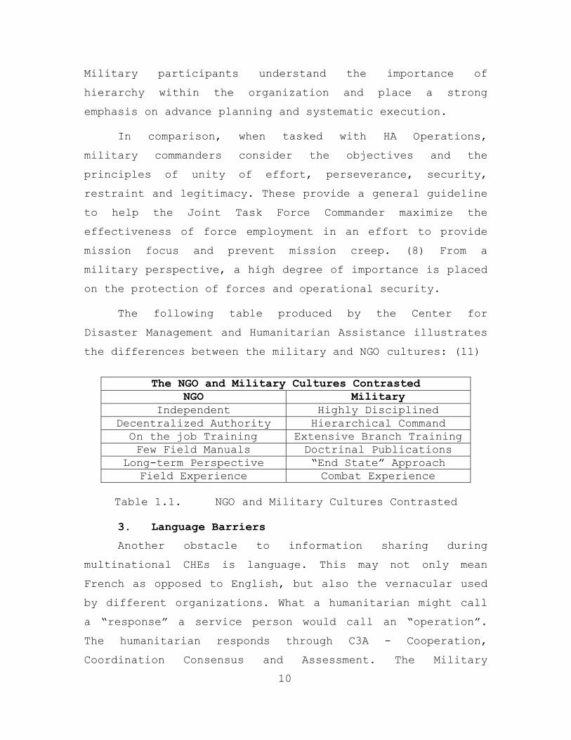
The following table produced by the Center for
Disaster Management and Humanitarian Assistance illustrates
the differences between the military and NGO cultures: (11)
The NGO and Military Cultures Contrasted
NGO Military Independent Highly Disciplined
Decentralized Authority Hierarchical Command On the job Training Extensive Branch Training Few Field Manuals Doctrinal Publications
Long-term Perspective “End State” Approach Field Experience Combat Experience
Table 1.1. NGO and Military Cultures Contrasted
3. Language Barriers
10
Another obstacle to information sharing during
multinational CHEs is language. This may not only mean
French as opposed to English, but also the vernacular used
by different organizations. What a humanitarian might call
a “response” a service person would call an “operation”.
The humanitarian responds through C3A - Cooperation,
Coordination Consensus and Assessment. The Military
conducts an operation using C3I - Command, Control,
Communications and Intelligence. Even the use of the word
collaborator can mean two vary different things depending
on your organizational mental model. Humanitarians view
collaboration as a good thing, while the military uses the
word collaborator with negative connotations. (12)
Barriers are also formed because of the different
cultures and operating procedures within the various
agencies and military organizations. For example the U.S.
military may do things vary differently than a Canadian
force, and World Vision may have operating procedures that
differ from Irish Catholic Relief.
4. Competing Priorities and Perceptions
As complex humanitarian participants enter into the
region they each bring different priorities and
perceptions. In a CHE aligning mission and goals becomes
more challenging with so many different partners. Each
participant can have different approaches and operational
points of view. The military has a mission mind-set that
usually considers security at the top of their priority
list, while humanitarians tend to be focused on providing
relief. Thus, complex emergencies often become mired in a
morass of competing priorities and plans.
Effectively establishing priorities is how missions
are accomplished. This is especially true during CHEs. Each
organization struggles to fulfill its mandate or mission
and the pressures can sometimes be overwhelming. NGOs
naturally set their priorities based on donor support.
Donor support is usually limited which in turn can create
competition among NGOs. In order to demonstrate
11
effectiveness and ensure the necessary flow of financial
support, NGOS jockey for recognition and resources. These
competitive pressures often inhibit information sharing
among NGOs and other entities that are viewed as a threat
to mission viability and success. (10)
The military arrives with its own set of priorities
and interests. Those priorities reflect what is important
to the Joint Task Force Commander in order to ensure
mission success. Typically, the military will be concerned
with establishing priorities, measures of effectiveness
(MOEs) and developing an exit strategy for each mission.
The need to share information is contingent upon the
priorities established and the requirements of the overall
effort. Ultimately, from a military perspective,
information sharing depends on an entity's "need to know."
(IBID)
5. Professional and Cultural Norms
When it comes to sharing information, professional and
cultural barriers are issues that arise particularly in the
civilian-military relationship. As mentioned above the two
cultures are made up of people with very different personal
motives, professional backgrounds, and organizational
structures. The NGO views information sharing with the
military as a violation of its nonpartisan/nonaligned
status. Humanitarians want to protect their neutrality. In
the humanitarian’s view it is often the military forces
that have had a hand in creating the CHE in the first
place. (10) Northern Iraq and Kosovo are examples. NGOs
also view the military as quick to take information yet
slow to give it. They see the military collect and then
12
unnecessarily classify data shared by NGOs, thus preventing
free distribution to all involved at the field level. (2)
On the other hand, the military is concerned with
security and force protection. The challenges they face
during a CHE involve developing force structure, defining
rules of engagement and interpreting national and
international law. They are wary of information shared by
NGOs for fear that it is purposely inflated or twisted to
support their particular mandate or agenda. The information
provided by the NGO might be presented in a way that
dramatizes a given situation in an effort to rally donor
support. The information can also be difficult to
substantiate because it is not generated within the
military intelligence system.
6. Lack of Trust and Stereotypes
As a result of the above-mentioned difficulties, a
lack of trust can develop among CHE participants. Lack of
trust in turn can lead to stereotyping. NGOs sometimes
perceive the military as responsible for the destruction of
homes, crops and livestock and guilty of serious offenses
such as rape, torture, genocide and violations of human
rights. And when the conflict does end, they see the
military leaving behind unexploded ordnance and landmines
that cause long-term human damage.
From the military side, NGOs are often viewed as
difficult to work with during CHEs. They want support yet
they demand autonomy. NGOs will not respond to orders given
by the military even if their personal safety is at stake.
The military see NGOs as resistant to the changes the
military brings and unwilling to collaborate in support of
13
military intelligence. NGOs on one hand will openly
criticize the military, while at the same time request
logistics, communications and transportation support from
those same military forces. (10, 11)
Based on these views of the other, neither group is
able to appreciate that each one provides a vital component
for mission success. The humanitarian has local experience
and provides professional expertise. He is independent and
able to respond quickly. The military provides security,
logistics and opens up a protected space for humanitarian
assistance to occur. Neither the military nor the civilian
can function effectively without the other. They are
interdependent during a CHE, making information sharing
essential for mission accomplishment.
E. METHODOLOGY
14
The first stage of this thesis will be to acquire an
understanding of the proof of concept developed by our
predecessors, Major Todd Ford, Major Jim Hogan and Major
Mike Perry.(1) They conducted a thorough analysis of
military Peace Operations and Humanitarian Assistance
Operations. Furthermore, they conducted a study of the
technology barriers that exist in the CHE environment. We
will use the results of their research to assist in
determining information requirements for both civilian and
military participants. The second stage will focus on
establishing partnerships with prospective sponsors. These
partnerships will help to further future development,
assist in testing of a prototype in a CHE environment, and
provide financial assistance for continued research. The
third stage of this thesis will be to develop a small-scale
prototype that will validate the information requirements.
This prototype will focus on web-based technologies, agent
architecture utilizing the DARPA CoAbs grid and wireless
networking in an austere environment. Finally, we will test
some of the functionalities of our proposed habitat.
F. ORGANIZATION
Chapter I provides background information on Complex
Humanitarian Emergencies. We examine the various reasons
why information sharing during Complex Humanitarian
Emergencies is difficult and state the scope and ultimate
goals for this thesis. Chapter II provides a review of the
current related organizational and technological prototypes
that are in development. Chapter III generates the
information and system requirements for the prototype.
Chapter IV describes the environment within which the final
product will be used. Chapter V outlines the structure of
the test bed. Finally, chapter VI concludes our thesis by
summarizing the research and makes recommendations for
further development.
15

THIS PAGE INTENTIONALLY LEFT BLANK
16
II. RELATED WORKS
A. INTRODUCTION
This chapter reviews two on going general solutions to
the problem of information sharing and coordination during
CHEs. The first addresses the organizational arrangements
that have been developed in recent years to improve
communications among participating organizations. We
briefly review those developed by the military and the UN,
indicating some of their successes and limitations. The
second general solution focuses on other developments in
information technology that may facilitate information
sharing during CHEs and is deserving of some attention.
B. ORGANIZATIONAL SOLUTIONS: MILITARY
Organizational solutions represent a range of
coordination mechanisms that have been developed by various
participating entities in a CHE. The list below is not
meant to be exhaustive, but it identifies the major
arrangements that have been devised by military
organizations to overcome information-sharing difficulties.
1. The Humanitarian Assistance Coordination Center
(HACC)
The HACC plays an important role during the early
stages of a large humanitarian crisis as seen in a Complex
Humanitarian Emergency. A US combatant’s command can
organize a HACC in order to open communication lines among
other US government agencies, NGOs and IOs. According to
Joint Doctrine, the HACC is considered to be a planning and
coordinating body that defines the strategy and develops an
early assessment of a Humanitarian Operation. (13) However,
17
in Operation Uphold Democracy, the HACC functioned more as
a clearinghouse for organizations requesting assistance
(25), normally done by the Humanitarian Operations Center
or the Civil Military Coordination Center.
2. The Humanitarian Operations Center (HOC)
According to joint doctrine, “the HOC is primarily an
international and interagency policy making and
coordinating body.” (13) The HOC is not a command and
control agency. The primary goal for the HOC is to
coordinate the overall relief strategy, to focus resources
and maximize the combined effort of all agencies involved.
A large part of what the HOC strives to do is to focus the
combined efforts of all involved by identifying and
prioritizing humanitarian logistics and support
requirements.
The HOC can be established by one of three entities:
The host nation government, the UN, or if a US-led
unilateral operation, the Office of Foreign Disaster
Assistance (OFDA). The Host Nation government can establish
a HOC in an effort to maximize the coordination of the
humanitarian aid effort. If the host nation government is
functioning, then the HOC will most likely operate closely
with some sort of Emergency Operations Center. In essence,
the HOC provides a host nation with a way to coordinate and
prioritize assistance from international agencies and
militaries.
In many CHEs, the government of the affected region is
no longer functioning. In these cases the UN will take
responsibility to establish a HOC. NGOs, IOs and military
representatives will use the HOC as a multi-agency
18

organizational design tool to ensure coordination and a
unified effort. An example of an UN-established HOC can be
seen in Somalia during Operation Restore Hope. The southern
portion of Somalia was divided into eight separate regions
called Humanitarian Relief Sectors. A HOC was established
within each sector to facilitate coordination. (14)
Although there is no formal membership for the HOC, it
generally consists of representatives from critical
agencies and organizations involved in the relief effort.
They can include the host nation, NGOs, International
Organizations, representatives from the US Embassy or
consulate and the UN.
In order to coordinate military support for the
various humanitarian agencies, the HOC maintains close
connections with another critical agency during CHEs known
as the Civilian Military Operations Center.
3. The Civil Military Operations Center (CMOC)
The CMOC functions more as an executive agency during
CHEs. It performs the liaison and coordination between the
military support structure, NGOs and PVOs, other agencies,
and local authorities. (15) This coordination is vital for
the simple fact that NGOs and PVOs have valid missions and
concerns, which at many times may complicate the mission of
US forces. The CMOC is the place where things get done. It
is the day-to-day nerve center and critical point of
coordination for civilian and military agencies. The
interaction within the CMOC establishes the tone for the
operation. To quote Roy Williams, former Director of OFDA,
Bureau for Humanitarian Response, USAID, “the CMOC is not a
19
structure, but a relationship.” That relationship between
the military and civilian component is key to mission
success.
The JTF commander can establish a CMOC in an effort to
coordinate Humanitarian Assistance needs and match them
with military support capabilities. These needs can range
from transportation request to providing security for
supply convoys. Joint Publication 3-08 makes the following
statement on the establishment of CMOCs: “A commander at
any echelon may establish a CMOC to facilitate coordination
with other agencies, departments, organizations, and the
host nation. In fact, more than one CMOC may be established
in an AOR or JOA, and each is task-organized based on the
mission.” (16)
In order to better understand the dynamics of a CMOC,
we need to look at who operates within it. From the
military perspective, the membership of a CMOC should
consist of individuals with the authority to act on the
needs of the NGO community. Membership outside the Joint
Task Force consists of resident experts and knowledgeable
agency representatives. The following is a list of possible
CMOC participants:
Military
• Operations personnel
• Civil Affairs
• Communications
• Medical
• HOST Nation or participating forces
20
Civilian
• Host Country or local government representatives
• Representatives from NGOs and IOs
• Liaisons from service and functional components such as airfields and ports
• USAID/OFDA and DART representation
• Department of State and other US government agencies
Although there is a suggested organization and
membership highlighted within Joint Doctrine, it is
important to remember the CMOC is a flexible and mission
specific concept. “The CMOC can be anywhere from a tent to
a tree, a place to meet all the operators who have power to
make decisions.” (10) In other words, no two CMOCs will
necessarily look or function exactly the same. This is a
natural consequence given the dynamic nature of CHEs. What
was needed during relief operations in Somalia might not be
needed in Afghanistan or Iraq.
The CMOC seems to function more like a political
committee than a structured command system. The military is
not in charge. There is no power to direct or enforce. The
CMOC strives to develop consensus, ensure focus of effort
and maximize available assets through situational
awareness. Constituted in this way, the CMOC becomes the
primary tactical/field level communication, coordination
and information sharing system. The information push-and-
pull requirements are monumental and often conducted under
austere conditions. The following list of CMOC functions
taken from Joint Publication 3-57 highlights the wide range
of information requirements:
21
• Providing nonmilitary agencies with a focal point
for activities and matters that are civilian related
• Coordinating relief efforts with US and/or multinational commands, United Nations, host nation, and other nonmilitary agencies
• Providing interface with the US Information Service, US Agency for International Development (USAID), and the Country Team
• Assisting in the transfer of operational responsibility to nonmilitary agencies
• Facilitating and coordinating activities of the joint force, other on-scene agencies, and higher echelons in the military chain of command
• Receiving, validating, coordinating, and monitoring requests from humanitarian organizations for routine and emergency military support
• Coordinating the response to requests for military support with Service components
• Coordinating requests to nonmilitary agencies for their support
• Coordinating with Disaster Assistance Response Team deployed by USAID/Office of Foreign Disaster Assistance
• Convening ad hoc mission planning groups to address complex military missions that support nonmilitary requirements, such as convoy escort, and management and security of refugee camps and feeding centers
• Convening follow-on assessment groups
4. NATO Civil-Military Cooperation Centers (CIMIC)
NATO defines the CIMIC as the co-ordination and co-
operation, in support of the mission, between the NATO
Commander and civil actors, including the national
population and local authorities, as well as international,
22
national and non-governmental organizations and agencies.
US forces usually refer to this as Civil Military
Operations (CMO). (17)
CIMC functions range from sustaining life to restoring
governments. A dedicated staff working at the headquarters
level develops CIMIC operations. Their main goal is to
ensure effective civil-military cooperation in execution of
the allied commander’s CIMIC plan. The tasks are then
executed by the CIMIC group. The CIMIC group is comprised
of specialists in the following fields:
• Public Affairs
• Civil Infrastructure
• Humanitarian Aid
• Economic and Commercial Structures and
• Judicial matters
In recognition of the importance of fostering an open
dialog between military and civilian participants, NATO
forces will set up a dedicated means of communications.
This is accomplished when the CIMIC staff establishes a
CIMIC Center.
As seen in Bosnia-Herzegovina, NATO forces established
a CIMIC Center to provide a location where NGOs, IOs and
military personnel could coordinate and share information.
In essence, it provided much of the same functionality as a
HOC or CMOC.
23
Any level of command can establish a CIMIC in order to
facilitate coordination among agencies. Preferably, CIMICs
are located outside the military compound and in closed
proximity to other major agencies. This promotes ease of
access to all participants and recognizes the concerns
humanitarians have of remaining separate from the military.
The functions of the CIMIC Center include:
• Provide initial points of contact
• Provide a focal point for liaison
• Facilitate information exchange
• Provide advice on the availability and mechanics of military assistance to civilian organizations and
• Re-enforce the legitimacy of the Force in the eyes of the local population
C. ORGANIZATIONAL SOLUTIONS: UN PERSPECTIVE
When the UN spearheads humanitarian operations,
coordinating systems take on different names but
essentially provide the same functions as the military. The
UN mechanisms for coordinating between humanitarian
participants, official entities and agencies are the On-
site Operations Coordination Center (OSOCC) and the
Humanitarian (Community) Information Center (HIC/HCIC).
1. On-Site Operations Coordination Center (OSOCC)
The OSOCC is a mechanism used by the UN Office for the
Coordination of Humanitarian Affairs (OCHA) to do many of
the same functions the HOC or CMOC accomplishes. The OSOCC
provides a rapid assessment and coordination capability
during the initial stages of a disaster. As mentioned in
chapter one, humanitarian agencies are often operating
within an affected region well before the military
component of a Complex Humanitarian Emergency. The OSOCC is
one of the early coordination tools used by the UN. (18)
24
The UN establishes the OSOCC for the use of the United
Nations Disaster Assessment Coordination (UNDAC) team. The
UNDAC team is a stand-by team of voluntary disaster
management professionals that can be deployed within hours
to carry out rapid assessment and help local authorities in
cases of environmental emergencies and natural disasters
such as floods and earthquakes. UNDAC members are
considered specialist within their field and are under the
direction of the United Nations, Office for the
Coordination of Humanitarian Affairs. (IBID)
2. Humanitarian (Community) Information Center
(CIC/HIC)
The HIC works to guarantee an on-going exchange of
information concerning security, humanitarian activities,
communications, sector assessments, requests for
humanitarian aid assistance, and requests for the use of UN
assets. The HIC serves as a physical place where
organizations involved in implementing the humanitarian
response can come together. The center strives to provide
humanitarians with an overall view of the situation. This
serves to focus individual efforts where they are needed
most. HICs provide the vital function of collecting,
analyzing and disseminating information.
The HCIC model was seen in Kosovo. It was established
in part by the UN Office for the Coordination of
Humanitarian Affairs (OCHA) to assist in the UN-led
repatriation effort of Kosovar Albanians. The HCIC
functioned as a one-stop coordination and information
source for NGOs and IOs. The primary role of the HCIC in
Pristina, Kosovo was to promote and facilitate coordination
by serving as an information focal point for local and
25
international NGOs, UN and other inter-governmental
agencies, donors and KFOR. (19) This was accomplished in
part by providing contact lists, local maps and organizing
daily briefings for the humanitarian community. The HCIC
was also instrumental in standardizing data formats and
developing protocols to ensure the widest dissemination of
vital information.
D. TECHNOLOGY SOLUTIONS: OVERVIEW
Each of the organizational arrangements described in
the above section offers an example of how to coordinate
and share information during CHEs. They have provided some
relief, but organizational duplication and the potential
for confusion still exists. As LTC Michael M. Smith,
CMO/PSYOP Policy Branch Chief, USSOCOM - “it’s an alphabet
soup” of different terms and systems describing much of the
same things.” Despite the progress that has been made,
coordination problems to a large extent still remain. Thus,
many organizations are turning to information technology to
deal with their collaboration problems. In large measure,
this has been due to the affects of Moore’s Law and the
rapid development and expansion of the Internet. Today,
satellite and Internet technology is being used in such
places as Central Asia and the Middle East to help in
complex humanitarian efforts. Military and civilian
organizations alike have recognized the benefits of
developing and using virtual networks and software tools to
enable information sharing and facilitate collaboration,
communication and coordination.
26
Figure 2.1 is a graphic representation of key
information technology systems that in some way support
information sharing during CHEs. The graphic illustrates
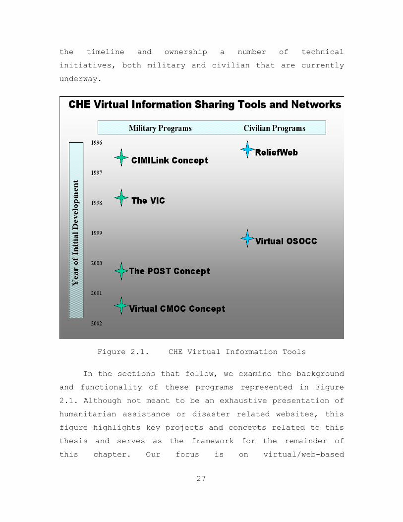
the timeline and ownership a number of technical
initiatives, both military and civilian that are currently
underway.
Figure 2.1. CHE Virtual Information Tools
In the sections that follow, we examine the background
and functionality of these programs represented in Figure
2.1. Although not meant to be an exhaustive presentation of
humanitarian assistance or disaster related websites, this
figure highlights key projects and concepts related to this
thesis and serves as the framework for the remainder of
this chapter. Our focus is on virtual/web-based
27
applications and networks that provide not just news and
information, but tap into one or more of the following:
• Virtual collaboration tools
• Web-based operational analysis
• Current planning data
• Synchronous and Asynchronous applications and
• Critical/timely information sharing
E. TECHNOLOGY INITIATIVES: MILITARY
1. The CIMILink Project
a. Background
As far back as 1996 the Department of Defense
recognized the key role technology could play in the effort
to improve communication between NGOs and the military in
humanitarian and peace operations. After Complex
Humanitarian Emergencies such as those in Northern Iraq,
Somalia and Haiti, the National Defense University’s (NDU)
Institute for National Strategic Studies (INSS) Directorate
for Advanced Concepts, Technologies, and Information
Strategies (ACTIS) attempted to capitalize on lessons
learned. As a result of these efforts a subsequent
technological research effort developed and became known as
the CIMILink Project. (20)
The CIMILink project began as a result of a
series of workshops held in April of 1996 by the
Directorate for Advanced Concepts, Technologies, and
Information Strategies (ACTIS). These workshops were
entitled -- Humanitarian and Peace Operations: The
28
NGO/Interagency Interface. They were conducted in order to
specifically focus on the civilian – military interface
during peace operations.
ACTIS brought together a number of key players
from different humanitarian and military communities. They
highlighted the problems of communication and coordination
during all phases of humanitarian operations and looked
into the feasibility of “improving communications between
the two communities and within the NGO community itself by
developing a networking mechanism to share information,
possibly using computer technology.” (21)
As a result of this workshop, ACTIS began support
for the research, development and fielding of an
information system that was “low-cost, user-friendly,
responsive to the information needs of the Government and
the NGO community, and compatible with the needs of the
military.” (IBID) The DoD Command and Control Research
Program (CCRP) began sponsorship of the Civil
Affairs/Coalition Forces Decision Aids prototype/CIMILink
Project.
29
The goal of this project was to develop a set of
software tools designed to support the exchange of
information and the creation of a common perception of the
situation among participants responding to a CHE. The
development process used workshops and small focus groups
to refine requirements. Based on this data, a set of
computer-based tools was developed to facilitate
information sharing and support the integrated planning and
execution of relief missions. These tools were to be
incorporated into a field ready prototype. The U.S. Army
Communications-Electronics Command (CECOM) would spearhead
the technical aspects of the prototype, while Evidence
Based Research Inc, (EBR) a defense contractor focused on
the content, overall design, data development, and testing
and evaluation.
The CIMILink initial prototype was demonstrated
to a number of agencies with favorable response. After
presenting the project to Volunteers in Technical
Assistance (VITA), EBR learned of a similar research effort
underway sponsored by the UN. A partnership was proposed
involving VITA, the UN, EBR/NDU, and CECOM to combine
efforts. The resulting design would be fielded in support
of a World Bank/World Food Program project with the
government of Sierra Leone’s Ministry of National
Reconstruction, Resettlement, and Rehabilitation (MNRR).
The MNRR established the Integrated Information
Center (IIC) where coordination and monitoring of programs
was conducted and critical information shared. The CIMILink
prototype would be used within the IIC to facilitate
information sharing. (21)
b. Functionality
The initial core of the system was known as the
“CiMiLink Electronic CMOC”. The Electronic CMOC was built
around Bulletin Board System (BBS) technology that was
customized to reflect the needs of CHE actors. The bulletin
board would contain various categories of information,
accessible either within a CMOC/HOC/OSOCC/CIMIC Center, or
remotely through cell phone, HF radio, or telnet.
30
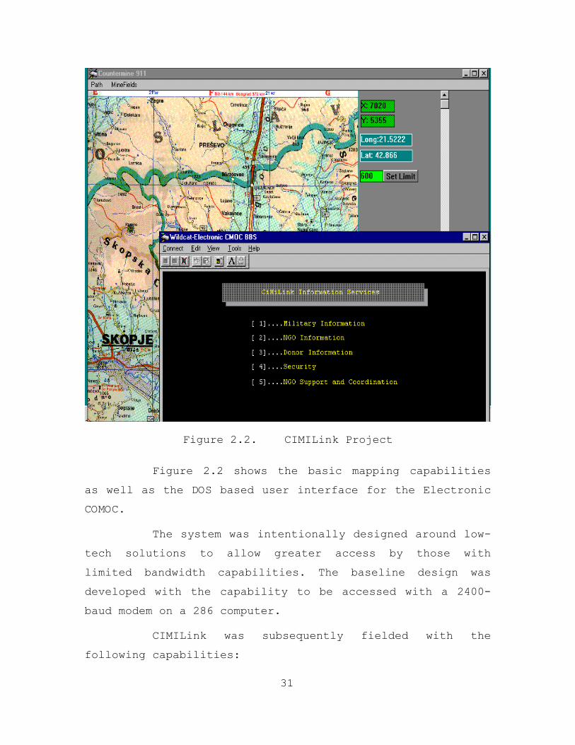
Figure 2.2. CIMILink Project
Figure 2.2 shows the basic mapping capabilities
as well as the DOS based user interface for the Electronic
COMOC.
The system was intentionally designed around low-
tech solutions to allow greater access by those with
limited bandwidth capabilities. The baseline design was
developed with the capability to be accessed with a 2400-
baud modem on a 286 computer.
CIMILink was subsequently fielded with the
following capabilities:
31
• Email when Internet access was available
• File transfer capability
• Topic areas with critical information
• Remote connectivity for database access and online queries
• Digital mapping systems with country datasets
The CiMiLink program went on to form the backbone
of the Sierra Leone Integrated Information Center (IIC).
The system was field tested over a six-month period with a
United Nations organization having a direct impact on the
dissemination of data and providing information services
within the IIC. Although VITA subsequently provided EBR
with valuable feedback and design recommendations, the
CIMILink project did not progress on after 1997. (20)
2. NEO Tracking System 2000
a. Background
One of the key military operations other than war
(MOOTW) missions that the Marine expeditionary unit (MEU)
special operations capable (SOC) training program prepares
deploying MEUs to execute is the noncombatant evacuation
operation (NEO). NEOs are generally defined as missions
conducted to support DoS in evacuating noncombatant and
nonessential military personnel from a host foreign nation
to an appropriate safe haven and/or the U.S. (24)
Throughout the history of our expeditionary
force, this mission has been routinely executed with
examples ranging from the actions in the 18th and 19th
centuries to more recent ones listed below:
32
• Nobel Response, Kenya and Tanzania (August 1998)
• Shepard Venture, Guinea Bissau (July 1998)
• US Embassy; Asamara, Eritrea (June 1998)
• Silver Wake, Albania (4 June - 14 July, 1997)
• Nobel Obelisk, Sierra Leone (27 May - 6 June, 1997)
• Guardian Retrieval, Zaire (2 May - 5 June, 1997)
• Assured Response, Monrovia, Liberia (1996)
• Sierra Leone (May 1992)
• Quick Lift, Kinshasha, Zaire (September - October 1991)
• Fiery Vigil, Clark Air Force Base, Philippines (June 1991)
• Eastern Exit, Mogadishu, Somalia (2-11 January, 1991)
• Sharp Edge, Monrovia, Liberia (May 1990 - January 1991)
• Eagle Pull, Phnom Penh, Cambodia (1975)
• Power Pack, Dominican Republic (1965-66)
Processing and maintaining accountability of
evacuees throughout the entire evacuation process, from the
evacuation coordination center (ECC) to the Amphibious
Ready Group/Marine Expeditionary Unit (ARG/MEU) or airfield
or safe haven continues to hinder our military forces. New
technologies have been developed that enables our US forces
to improve NEO mission execution.
b. Functionality
The question of evacuee tracking and
accountability is not answered by Marine Corps doctrine. JP
3-07.5 does not address the issue of how to track evacuees
33
throughout the process. Instead, an answer may be found in
some of today's existing technologies.
An evacuee, or POW/EPW/refugee for that matter,
presents a passport, a scanner scans it, and the
information entered into a database. Now take that same
computer and place it within a computer network with a
server. It can now talk with another computer station doing
the same thing and create a database of all evacuees being
processed. The server could use the Internet or phone lines
to relay this information to the ship or higher
headquarters if necessary. Now the ship/higher can track
all evacuees throughout the entire process. Couple several
evacuee-processing stations equipped with digital scanners,
linked by wireless modems to a common server, and match the
server with a satellite phone, and you now have an answer
to the MEU's evacuee accountability problem. The marriage
of existing, off-the-shelf technologies has resulted in the
NEO Tracking System 2000. (24)
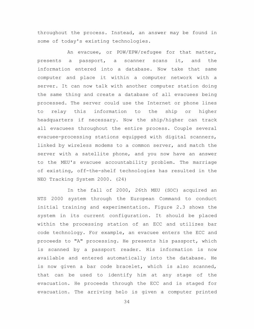
In the fall of 2000, 26th MEU (SOC) acquired an
NTS 2000 system through the European Command to conduct
initial training and experimentation. Figure 2.3 shows the
system in its current configuration. It should be placed
within the processing station of an ECC and utilizes bar
code technology. For example, an evacuee enters the ECC and
proceeds to "A" processing. He presents his passport, which
is scanned by a passport reader. His information is now
available and entered automatically into the database. He
is now given a bar code bracelet, which is also scanned,
that can be used to identify him at any stage of the
evacuation. He proceeds through the ECC and is staged for
evacuation. The arriving helo is given a computer printed
34
roster with the stick's info, but the miniserver is also
sending this info via satellite phone directly to the
ARG/MEU.
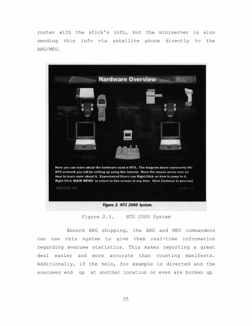
Figure 2.3. NTS 2000 System
Aboard ARG shipping, the ARG and MEU commanders
can use this system to give them real-time information
regarding evacuee statistics. This makes reporting a great
deal easier and more accurate than counting manifests.
Additionally, if the helo, for example is diverted and the
evacuees end up at another location or even are broken up
35
into other groups for transportation, a scanning of their
bar code bracelets would easily reorganize them and regain
accountability.
3. Virtual Information Center (VIC)
a. Background
In 1997, the U.S. Pacific Command (USPACOM)
participated in a Command and Control Research Program
(CCRP) sponsored workshop entitled: Humanitarian Assistance
and Disaster Relief in the Next Century. (25) The focus of
the workshop was to use new concepts to apply information
superiority to future Humanitarian and Disaster Relief
HA/DR operations. The workshop’s goal was to somehow match
the unprecedented increase in information technology with
the mission needs of Humanitarian Assistance/Disaster
Relief, (HA/DR) type operations.
The various groups within the workshop recognized
the need to establish a collaborative environment and they
felt the military could play a key role. This environment
would be designed to support HA/DR information needs and
promote unity of effort among the diverse participants. New
technologies would create the backbone and support this
collaborative network. The proposed title for this Network
of networks was the Virtual Information Center (VIC).
Taken from the workshop Report the initial idea
behind the VIC was documented as follows:
The VIC would support both military and
NGO/PVO/IO communities’ participation in an HA/DR
operation. It would be netted in the field with reach-back
to home organizations for information support and material
36
tracking. The military would be a participant in this net,
but through a plug-in interface that protects it from
intrusion but provides standardized data translation that
can be shared with controllable subsets of the
participants. The network itself would be commercially
provided and the VIC interface function would probably be
provided as a UN service package by a selected NGO. (26)
The VIC concept went further to provide mapping,
weather, imagery, and other sensor and GIS services from
commercial sources. The general goal was for the VIC to
“stimulate the pooling of data, coordinate source selection
for information and fusion, provide data translation, and
promulgate data standards.” (IBID)
b. Functionality
Today, The VIC Program, although not true to
original form, currently supports the Commander, Pacific
Command (COMPACOM) by providing situational awareness in
the form of a fused Picture, developed through open source
means. (27)
37
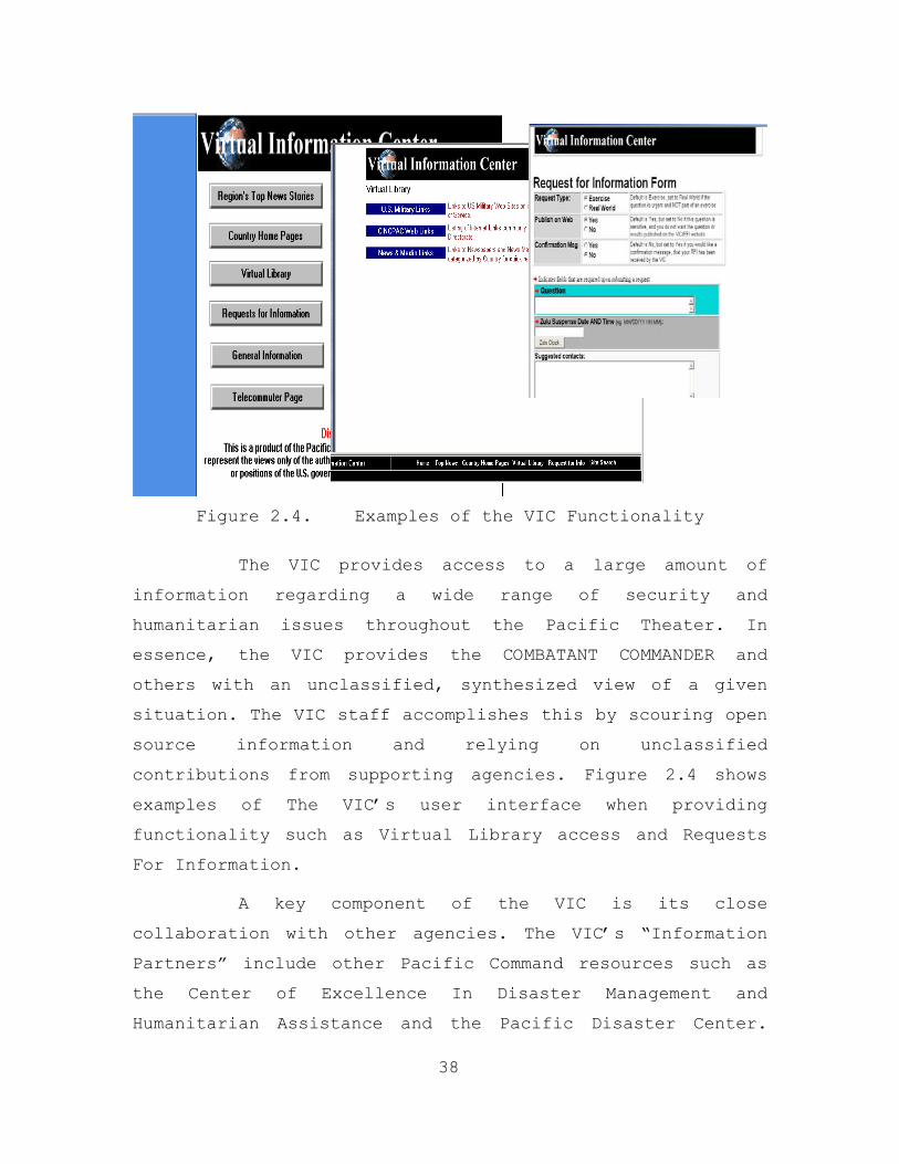
Figure 2.4. Examples of the VIC Functionality
The VIC provides access to a large amount of
information regarding a wide range of security and
humanitarian issues throughout the Pacific Theater. In
essence, the VIC provides the COMBATANT COMMANDER and
others with an unclassified, synthesized view of a given
situation. The VIC staff accomplishes this by scouring open
source information and relying on unclassified
contributions from supporting agencies. Figure 2.4 shows
examples of The VIC’s user interface when providing
functionality such as Virtual Library access and Requests
For Information.
A key component of the VIC is its close
collaboration with other agencies. The VIC’s “Information
Partners” include other Pacific Command resources such as
the Center of Excellence In Disaster Management and
Humanitarian Assistance and the Pacific Disaster Center.
38
The VIC’s functionality involves the ability to search,
collaborate, analyze, validate, integrate and disseminate
information generated in-house and through its
collaborative relationships. (IBID)
4. The Peace Operations Support Tool (POST)
a. Background
In December of 2000, a proposal from J081, U.S.
Pacific Command was submitted to prototype a tool that
would assist in collaboration and information sharing
during CHEs and Peace Operations. This tool would be user
friendly, intuitive and multi-platform capable. The goal of
this tool would be to “tie together a framework model of
complex humanitarian emergencies and peace operations,
related databases and other information sources.” (25) This
information would be categorized and accessible through a
web-based system. The entire system would function as a
collection of tools designed to support Complex
Humanitarian contingencies.
The system would be built around George Mason
Universities Conceptual Model of Peace Operations (CMPO)
developed by Professor D. F. Davis. The CMPO organizes the
results of extensive development in a collaborative
environment with representatives involved in CHEs and peace
operations. It is a structured hierarchy that models the
functions involved within the areas of peace operations
under three branches: Peace Making, Peace Building, and
Peace Support. Within these branches functions are broken
into sub functions down to six layers maximum. (28) The
model provides a solid organization of mission and
information needs and structural foundation for POST.
39
The POST project has gained recognition for its
value added potential during the planning and execution
phases of CHEs. Partnering with US Pacific Command (PACOM)
in this project are the Center of Excellence in Disaster
Management and Humanitarian Assistance, George Mason
University’s School of Policy Program on Peacekeeping
Policy, Australia’s Defense Science and Technology
Organization and the Institute for Defense Analysis.
b. Functionality
The POST provides CHE participants with access to
a wide range of information sources as well as a number of
technological tools. These have been presented in six broad
categories within POST. (29)
(1) Responding Organizations. Provides
information on responding organizations in different
categories, with COE tracking actual organizations as they
respond to a crisis.
(2) Lessons Learned: COE maintains a
repository of various lessons learned by a number of
organizations made available to users through the system.
(3) Subject Matter Experts: A complete
listing of experts within the fields associated with the
universe of CHE and Peace Operations. The system will
provide access of point of contact information.
40
(4) Analytical Tools: POST will provide
over 100 analytical tools developed by PACOM, U. S. Army’s
CAA, TRAC-Lee and Australia’s DSTO that pertain to CHE and
Peace Operations.
(5) Training, Readiness and Operational
Capability Requirements. A compilation of requirements
garnered through work with International Association of
Peacekeeping Training Centers.
(6) Measures of Effectiveness and Measures
of Performance. The POST will provide access to approved
MOEs and MOPs developed by International Organizations and
compiled by COE.
Figure 2.5 shows the index page and the subject
expert functionality of the POST Prototype.
41
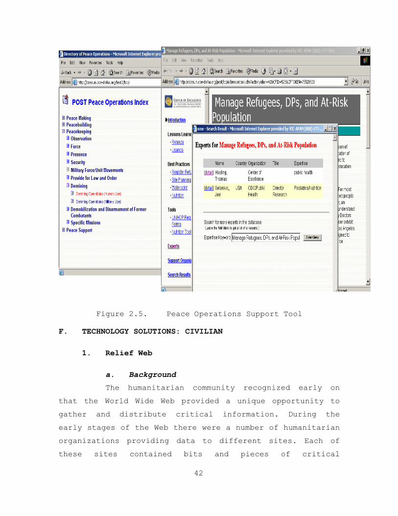
Figure 2.5. Peace Operations Support Tool F. TECHNOLOGY SOLUTIONS: CIVILIAN
1. Relief Web
a. Background
The humanitarian community recognized early on
that the World Wide Web provided a unique opportunity to
gather and distribute critical information. During the
early stages of the Web there were a number of humanitarian
organizations providing data to different sites. Each of
these sites contained bits and pieces of critical
42
information relating to humanitarian operations. In order
to gain information on a particular operation, one would
have to search a number of sites. The United Nations Office
for the Coordination of Humanitarian Affairs (OCHA)
recognized the need for a one-stop consolidation point for
all things relating to Humanitarian Assistance and Disaster
Relief. In 1996 they responded by establishing Relief Web
under the following mandate:
To strengthen the response capacity of the humanitarian relief community through the timely dissemination of reliable information on response, preparedness and disaster prevention. (30)
The founding concepts for Relief Web were born
from a bottom up consensus among NGOS and IOs that there
was a need to consolidate information. “Information was
seen as a public good, and that well informed decisions
should serve as the basis for relief actions.” (IBID)
Relief Web operates on the foundation that its partners
provide the core of its knowledge base. As a result, Relief
Web was recognized early on as a good idea and quickly
received buy in from a number of humanitarian, military and
government organizations.
According to Relief Web, it receives information
from over 700 sources, including NGOs, government agencies
and the media. (IBID) They strive to be relevant, dynamic
and responsive to their target audience, which is comprised
of a wide range of practitioners and advisors. Today Relief
Web has approximately 3.5 million hits weekly and is
recognized as the primary on-line source of humanitarian
information.
43
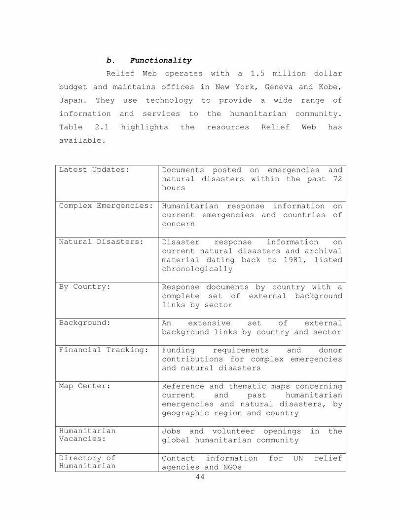
b. Functionality
Relief Web operates with a 1.5 million dollar
budget and maintains offices in New York, Geneva and Kobe,
Japan. They use technology to provide a wide range of
information and services to the humanitarian community.
Table 2.1 highlights the resources Relief Web has
available.
44
Latest Updates: Documents posted on emergencies and natural disasters within the past 72 hours
Complex Emergencies: Humanitarian response information on
current emergencies and countries of concern
Natural Disasters: Disaster response information on current natural disasters and archival material dating back to 1981, listed chronologically
By Country: Response documents by country with a complete set of external background links by sector
Background: An extensive set of external background links by country and sector
Financial Tracking: Funding requirements and donor contributions for complex emergencies and natural disasters
Map Center: Reference and thematic maps concerning current and past humanitarian emergencies and natural disasters, by geographic region and country
Humanitarian Vacancies:
Jobs and volunteer openings in the global humanitarian community
Directory of Humanitarian O i i
Contact information for UN relief agencies and NGOs
Organizations:
Library: An on-line archive of humanitarian, human rights and development reference documents
Emergency Telecommunications:
Information and resources available for the provision of emergency telecommunications during relief operations
Early Warning: Tracking potential emergencies and natural disasters as they develop
Relief Web via Email:
Making Relief Web available to those without web access
Central Register: A directory of disaster management resources available for humanitarian assistance
Table 2.1. Relief Web Resources
Relief Web focuses on providing high content in a
relative low-tech format. They make use of intuitive
interfaces and taxonomies, with little bandwidth spent on
graphics. Figure 2.6 shows Relief Web’s homepage, Financial
Tracking System and Directory of Humanitarian
Organizations.
45
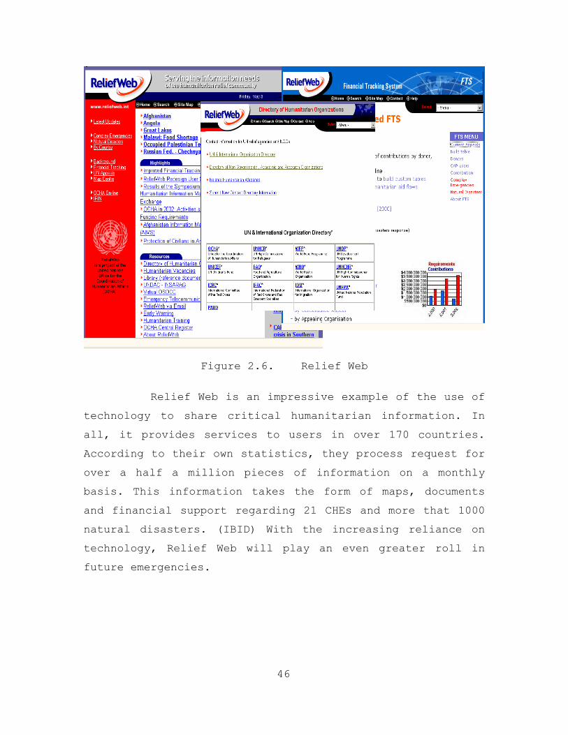
Figure 2.6. Relief Web
Relief Web is an impressive example of the use of
technology to share critical humanitarian information. In
all, it provides services to users in over 170 countries.
According to their own statistics, they process request for
over a half a million pieces of information on a monthly
basis. This information takes the form of maps, documents
and financial support regarding 21 CHEs and more that 1000
natural disasters. (IBID) With the increasing reliance on
technology, Relief Web will play an even greater roll in
future emergencies.
46
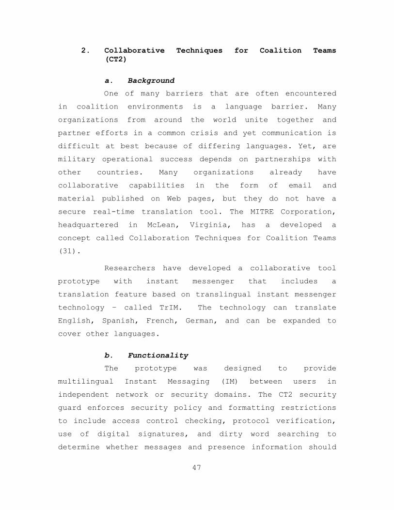
2. Collaborative Techniques for Coalition Teams (CT2)
a. Background
One of many barriers that are often encountered
in coalition environments is a language barrier. Many
organizations from around the world unite together and
partner efforts in a common crisis and yet communication is
difficult at best because of differing languages. Yet, are
military operational success depends on partnerships with
other countries. Many organizations already have
collaborative capabilities in the form of email and
material published on Web pages, but they do not have a
secure real-time translation tool. The MITRE Corporation,
headquartered in McLean, Virginia, has a developed a
concept called Collaboration Techniques for Coalition Teams
(31).
Researchers have developed a collaborative tool
prototype with instant messenger that includes a
translation feature based on translingual instant messenger
technology – called TrIM. The technology can translate
English, Spanish, French, German, and can be expanded to
cover other languages.
b. Functionality
The prototype was designed to provide
multilingual Instant Messaging (IM) between users in
independent network or security domains. The CT2 security
guard enforces security policy and formatting restrictions
to include access control checking, protocol verification,
use of digital signatures, and dirty word searching to
determine whether messages and presence information should
47
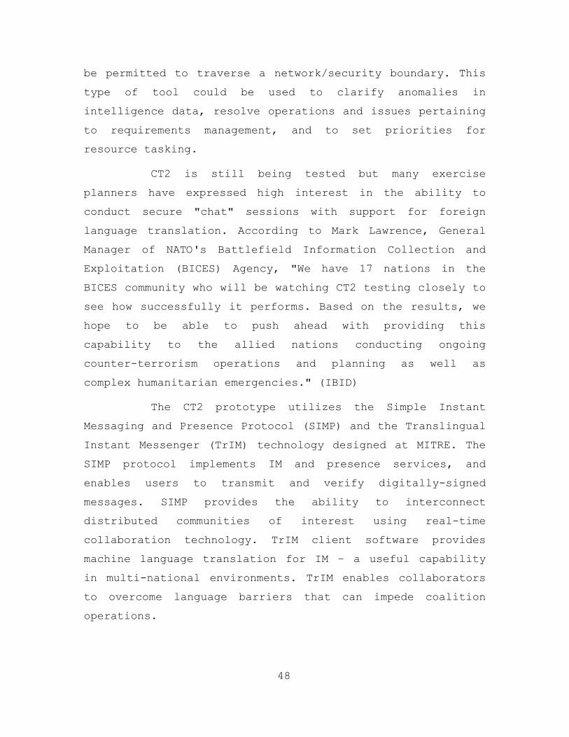
be permitted to traverse a network/security boundary. This
type of tool could be used to clarify anomalies in
intelligence data, resolve operations and issues pertaining
to requirements management, and to set priorities for
resource tasking.
CT2 is still being tested but many exercise
planners have expressed high interest in the ability to
conduct secure "chat" sessions with support for foreign
language translation. According to Mark Lawrence, General
Manager of NATO's Battlefield Information Collection and
Exploitation (BICES) Agency, "We have 17 nations in the
BICES community who will be watching CT2 testing closely to
see how successfully it performs. Based on the results, we
hope to be able to push ahead with providing this
capability to the allied nations conducting ongoing
counter-terrorism operations and planning as well as
complex humanitarian emergencies." (IBID)
The CT2 prototype utilizes the Simple Instant
Messaging and Presence Protocol (SIMP) and the Translingual
Instant Messenger (TrIM) technology designed at MITRE. The
SIMP protocol implements IM and presence services, and
enables users to transmit and verify digitally-signed
messages. SIMP provides the ability to interconnect
distributed communities of interest using real-time
collaboration technology. TrIM client software provides
machine language translation for IM – a useful capability
in multi-national environments. TrIM enables collaborators
to overcome language barriers that can impede coalition
operations.
48
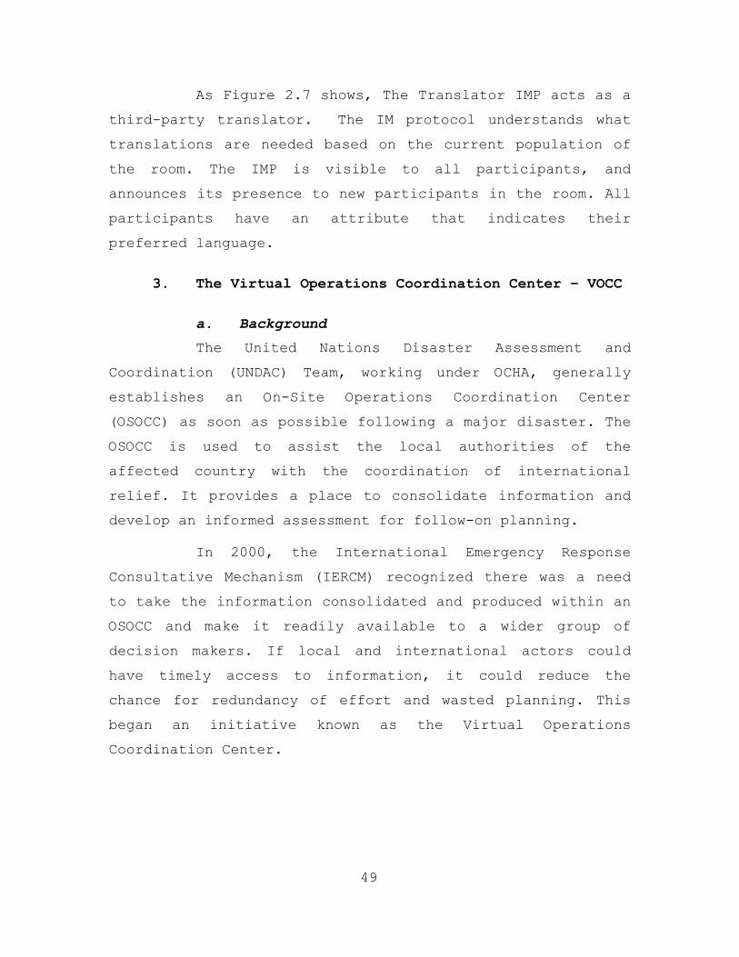
As Figure 2.7 shows, The Translator IMP acts as a
third-party translator. The IM protocol understands what
translations are needed based on the current population of
the room. The IMP is visible to all participants, and
announces its presence to new participants in the room. All
participants have an attribute that indicates their
preferred language.
3. The Virtual Operations Coordination Center – VOCC
a. Background
The United Nations Disaster Assessment and
Coordination (UNDAC) Team, working under OCHA, generally
establishes an On-Site Operations Coordination Center
(OSOCC) as soon as possible following a major disaster. The
OSOCC is used to assist the local authorities of the
affected country with the coordination of international
relief. It provides a place to consolidate information and
develop an informed assessment for follow-on planning.
In 2000, the International Emergency Response
Consultative Mechanism (IERCM) recognized there was a need
to take the information consolidated and produced within an
OSOCC and make it readily available to a wider group of
decision makers. If local and international actors could
have timely access to information, it could reduce the
chance for redundancy of effort and wasted planning. This
began an initiative known as the Virtual Operations
Coordination Center.
49
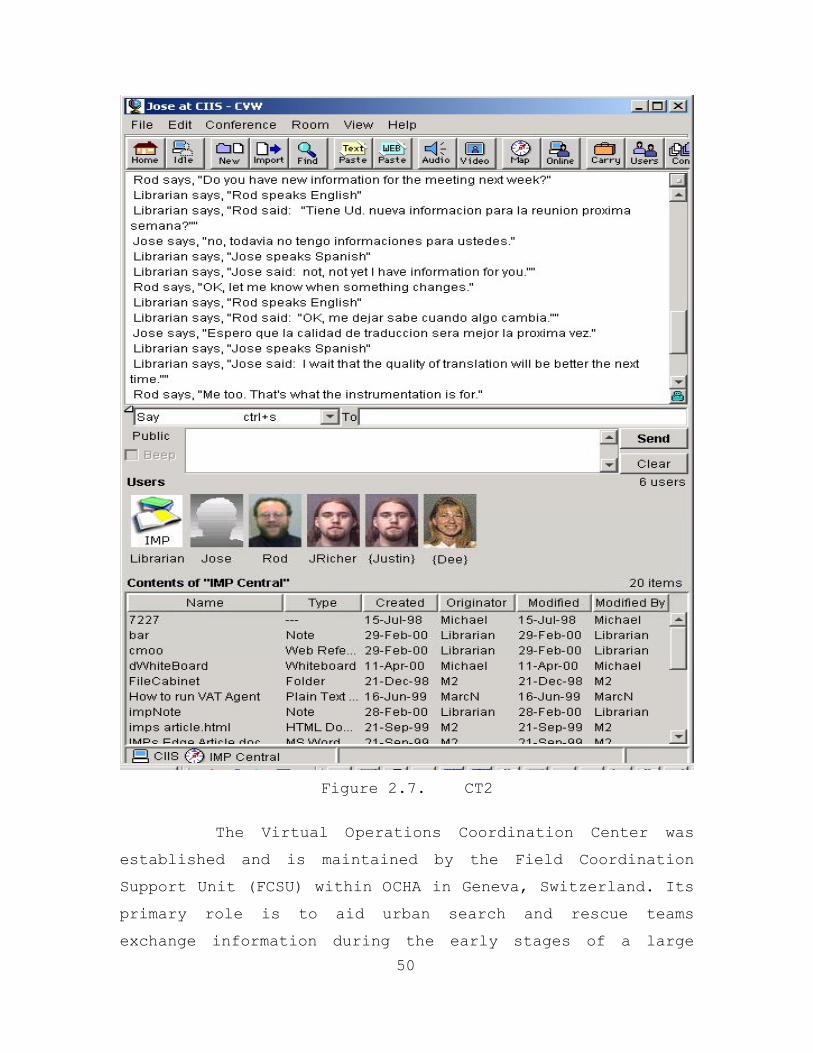
Figure 2.7. CT2
50
The Virtual Operations Coordination Center was
established and is maintained by the Field Coordination
Support Unit (FCSU) within OCHA in Geneva, Switzerland. Its
primary role is to aid urban search and rescue teams
exchange information during the early stages of a large
disaster. It allows information sharing when conventional
means, such as telephone and fax, have been disrupted. The
Virtual Operations Coordination Center strives to “create a
real-time communication vehicle for use during emergency
response.” (32) It accomplishes this by acting as an online
tool to enable information sharing between international
relief organizations.
b. Functionality
The Virtual OSOCC (Figure 2.8) provides a
complement of asynchronous tools and database access. Users
can access information relevant to a particular disaster,
participate in discussion groups or find out about various
training opportunities.
The Virtual Operations Coordination Center is a
tool specifically designed for disaster management experts.
The target audience for the Virtual OSOCC is a professional
core of disaster personnel that consists of the
International Search and Rescue Advisory Group (INSARG),
the International Emergency Response Consultative Mechanism
(IERCM) and members of the United Nations Disaster
Assessment and Coordination (UNDAC) Team. Access to the
Virtual OSOCC is restricted to these individuals or on a
case-by-case basis.
51
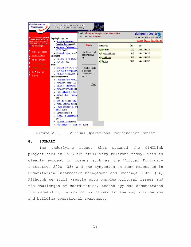
Figure 2.8. Virtual Operations Coordination Center
G. SUMMARY
The underlying issues that spawned the CIMILink
project back in 1996 are still very relevant today. This is
clearly evident in forums such as the Virtual Diplomacy
Initiative 2000 (33) and the Symposium on Best Practices in
Humanitarian Information Management and Exchange 2002. (34)
Although we still wrestle with complex cultural issues and
the challenges of coordination, technology has demonstrated
its capability in moving us closer to sharing information
and building operational awareness.
52
III. METHODOLOGY
A. INTRODUCTION
This chapter will outline how the information and
system requirements were derived for relief operations.
Afterwards, we will select a system model and, when
properly utilized, would be the foundation for developing
our proposed system solution. In conclusion, this chapter
describes our partnership development as well as a brief
overview of our future collaborative efforts.
B. REQUIREMENTS
The requirements development for creating an
information-sharing environment calls for a definition of
the current state and desired state of CHE operations. In
addition, we need to explain how technology can contribute
to the desired state. In chapter I we learned about the
current state. Organizations involved in CHEs are extremely
divers, each operates with its own agenda and priorities.
As a military footprint is established at the field level,
communication difficulties among the participants often
increases and produces shortfalls, friction and redundancy
of effort. These in turn can result in mutual distrust
among the parties.
A lack of shared information is a primary hurdle in
establishing effective relief efforts. The desired state
includes movement from a collection of uncoordinated
separate organizations that execute their relief responses
to an environment that allows for organizations to share
information using information technology that ultimately
increases situational awareness. As a result, situational
53
awareness increases, better decision-making occurs for all
parties involved, and lives are saved.
C. INFORMATION REQUIREMENTS
The first step in the process of requirements
generation is to determine what type of information needs
to be shared. We draw much of our information from the
Virtual Diplomacy Series “Taking it to the Next Level” (33)
and on our analysis of the personal interviews conducted
with relief organization workers actively involved in
Bosnia.
1. Conference on Information Sharing
In April 2000, the U.S. Institute of Peace and the
U.S. Army’s 353rd Civil Affairs Command co-sponsored a
conference in San Antonio, Texas. The conference report,
“Taking it to the Next Level, Civilian-Military Cooperation
in Complex Emergencies,” (IBID) recommends information
sharing mechanisms to support advanced planning and program
implementation by international entities involved in CHEs.
Participants at the conference identified ongoing
information needs for both humanitarian and military
organizations. Both require accurate and comprehensive
information about conditions and activities in the field.
Just knowing what information could be exchanged before
they come into contact in the field would help manage
expectations and reduce suspicions about one another’s role
during a crisis. Unfortunately, not all information is
posted in a central or easily accessible location.
Minefield or unexploded ordinance locations, infrastructure
damage, military or relief staff rotations are not usually
made available to all parties. The lack of notice to the
54
civilian sector about military rotations was a particularly
vexing problem for NGOs during the multinational
Stabilization Force in Bosnia (SFOR). There was little, if
any, continuity in cooperative relationships and joint
projects as a result. As conference participants noted:
Each CHE is different in some respects, but some aspects are similar across crises. One such commonality is the need to acquire, compile, analyze, disseminate, and use information before, during, and even after the emergency. No single approach can satisfy everyone's informational needs, yet there exists in every crisis a core of key information that has wide applicability for all those responding to the crisis. However, despite occasional information sharing, this practice has not been sufficiently institutionalized. Thus, collaboration between civilian and military entities cannot be counted on and is difficult to mobilize at the appropriate time. (IBID)
2. Interviews from Bosnia
In July 2001, a member of the previous thesis group,
Major Todd Ford, traveled to Sarajevo, Bosnia, to conduct
interviews with designated representatives from NGO, IO and
military organizations. (1) The purpose was to collect
additional data to establish the requirements for their
proof-of-concept application.
A listing of the interviewees and a summary of each
interview can be found in the Bosnia Trip Report within
Appendix A of the Ford/Hogan/Perry thesis. (1) The trip
report provides background information on each interviewee
as well as a detailed account on topics these individuals
felt were critical to the problem of information sharing
and coordination during a CHE.
55
The following information was compiled from these
interviews. The content of each interview was categorized
into problem statement, information requirement, and
technical issues.
a. Problem Statement
The problem statement described by the
interviewees mirrored the coordination and information
sharing difficulties previously identified in the
conference report and those outlined in chapter one. As
Goran Tinjic, an Operations Analyst with World Bank summed
up his experience in Kosovo: The “lack of coordination led
to an uncoordinated, messy effort. There was total chaos in
the relief efforts.” Most agreed that given the current
situation, “anything is better that nothing.”
b. Information Requirements
The interviewees in Bosnia described the
following information requirements during a CHE.
(1) The specific mandate of each
organization is critical to reducing redundancy and wasted
effort and increasing situational awareness. Every
organization, regardless of size, needs to post its mandate
so that those involved in the relief effort can see who is
participating and what the mission is.
(2) Human resource and support information
regarding the NGOs and their organizations involved in the
relief effort are important. Specific information from
each NGO should include: the primary point of contact
(POC); the skill sets each NGO possesses; the time the NGO
will be involved in the relief effort; the background,
56

experience, and expertise of the workers; and the support
equipment, (logistics, medical, shelter) that is available.
(3) Critical to the relief operation is the
ability to locate, track and return to their homes of
origin all displaced persons and other migrants.
Interviewees expressed a need for a database connected to a
website for managing displaced persons with information
such as age, medical conditions, family members, home of
origin and current location.
(4) Often field workers have the best
situational awareness of the relief effort. Their
information should be consolidated and passed on to all
organizations, especially their assessments on medical
treatments, food, shelter, and clothing.
(5) Information about the infrastructure in
the area of operations is needed to understand what
capability is available for the relief effort and what
needs to be built or supplied to a community to get it
functioning again. Examples of infrastructure items are
utilities, roads, schools, hospitals and stores.
(6) Timely, accurate and updated
information to establish situation awareness is critical
and would include such things as the location of danger
areas, hot spots and safe areas, daily briefings, current
maps and locations of organizations in the area, weather
information, and local crop information. Providing
information on the location of all personnel,
organizations, and activities is also essential.
57
(7) Information on communication systems
(radio frequencies, phone lines, wireless, computer
networks, etc) is important to facilitate coordination.
(8) Information on transportation and
logistic support enables relief workers to know when, how,
and where they can travel and move supplies. By
maintaining a central repository, this information could be
available to everyone and accessed from anywhere.
(9) Background information is helpful
before workers are sent to the field. They would find
value in having information on the history of the area, the
reasons for the crisis, the norms and customs of the
people, especially what is considered appropriate or
inappropriate behavior, the social and economic context,
and the political climate. Most importantly, they suggest
collecting and disseminating information on the priorities
for aid as seen by the people needing assistance.
c. Technical Issues
Interviewees identified the following technical
issues that need to be considered when designing any
information technology solution that may be used for a CHE.
• Many CHEs occur in underdeveloped countries that
do not have mature telecommunication infrastructures to support wide area networks. The majority of relief organizations still connect to the Internet and local networks using dial-up telephone modems with an average connection speed of 19.2 kbps. This is a critical consideration for application designs, especially when making decisions about the amount of bandwidth required.
58
• Information must be accurate and capable of being updated quickly.
• The majority of users have computers running some version of a Windows Operating System and application programs from Microsoft Office.
• The technical training/experience level of field workers ranges from the proficient user down to the completely inexperienced. Some training will be required to ensure an acceptable level of proficiency with the application and hardware tools.
• Many NGOs lack funds to procure and maintain information technology equipment and to build communications infrastructures.
• Interviewees recommended that the UN or other neutral third party (contractor) should host and maintain the information system. This would ensure an unbiased perspective to the application and encourage participation and information sharing by all.
• NGO’s range from large organizations to individuals. A system must be put in place that enables everyone to share information equally. For example, an Irishman was working to rebuild some schools outside of a small town. He was not affiliated with any particular organization and used whatever material he could get on his own. He needed access to the same type of information and resources as the larger organizations.
D. SYSTEM REQUIREMENTS
Failure to share information, catalog resulting
assessments, or to update existing assessments, has
increased suspicions, frustrations, and apathy among
community members toward the international participants.
Conference attendees agreed that information sharing with
nationals should be given a priority and would go a long
way in strengthening performance in the field.
59
To address the needs outlined in the Conference Report
and the Kosovo interviews, the previous thesis group
created a proof of concept, called the Relief Operations
Coordination Center (ROCC), that is essentially a web
enabled database that would serve as a central repository
for a lot of the information needed by all parties within a
given CHE. (1) But, the ROCC is just a small solution in
achieving a greater desired systems solution. Our vision is
to develop a robust information-sharing “habitat”, within
which some functionality of the ROCC will be embedded, and
which will allow other components within the habitat to
share resources. This will be described in further detail
in Chapter IV.
In designing such a “habitat”, we have defined the
following system requirements:
• The creation of an information clearinghouse that is publicly available, interoperable, comprehensive, trustworthy, donor supported, and is the principal repository for humanitarian activity information.
• A communications system that is rapidly deployable anytime and anywhere. Must have reach back capability. Highly mobile and able to interface with a larger more robust system once the CHE reaches a more mature state. Mobile capability to include the use of wireless and handheld technologies.
• The ability to integrate Off-the-shelf architecture, common templates, and standardized protocols.
• Management by neutral entities (e.g., ICRC or a UN lead agency or its implementing partner). Must contain management functionality and tools.
• A system that is sustainable, reliable, and unclassified, and that "does no harm."
60
• An advanced collaborative tool that has peer-to-peer/client server functionality that also will provide real-time interaction and communication. Functionality within the tool should include file sharing/editing, whiteboard, chat, VoIP, project management, and browse capability.
• The ability to access web based applications and to be interoperable with other legacy systems is critical since they will be prevalent within many third world countries.
• Global Positioning System (GPS) that can be utilized on a pocket PC.
• The VCMOC should contain the following requirements:
• A listing of the organizations and their
mandates involved in the relief effort.
• Points of contact for organizations involved in the relief effort including a listing of the skills, supplies and number of people being provided by each organization and the assets they have available.
• The capability to manage displaced persons, tracking home of origin, current location, family members, sex, age and medical condition.
• The ability to search a database to locate specific organizations, points of contact, needs and requirements of displaced persons.
• Timely and accurate situational awareness information concerning the history, current situation and projected situations for the relief area to include danger areas, infrastructure, safe areas, access routes, media contacts, local authorities and maps.
• A tool to better coordinate and communicate between NGO and military units involved in the relief operation.
61
• Awareness of logistical needs such as medical, food, shelter and clothing supplies, where they are needed, when and how much.
If such an information sharing habitat could be
developed and implemented, many organizations and
participants could save millions of dollars in wasted
resources that could be better utilized in supporting the
relief effort.
E. MODEL DEVELOPMENT
As we evaluated the many system models discussed, it
was felt the above Kast & Rosenzweig model, Figure 3.1,
most closely resembled the environment in which CHEs should
operate. This system embodies all the characteristics that
all organizations involved need to address to ensure
successful emergency operations.
62
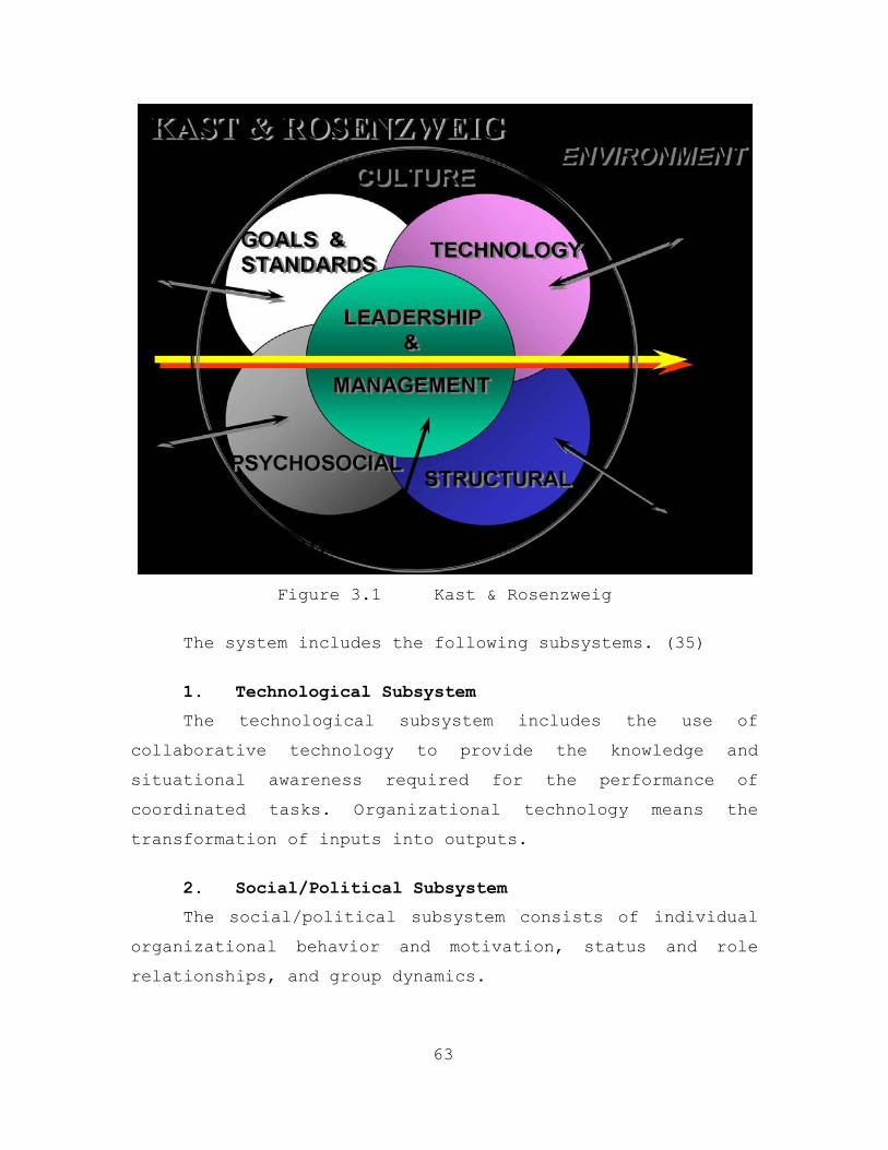
Figure 3.1 Kast & Rosenzweig
The system includes the following subsystems. (35)
1. Technological Subsystem
The technological subsystem includes the use of
collaborative technology to provide the knowledge and
situational awareness required for the performance of
coordinated tasks. Organizational technology means the
transformation of inputs into outputs.
2. Social/Political Subsystem
The social/political subsystem consists of individual
organizational behavior and motivation, status and role
relationships, and group dynamics.
63
3. Structural Subsystem
Intermixed with technical and social/political
subsystems are the structure. Structure is concerned with
the ways in which the tasks of the organizations involved
are divided and with the coordination of these activities.
It is concerned with communication and workflow.
4. Goals and Values Subsystem
Goals and values represent one of the more important
subsystems. Knowing and understanding the goals and values
of the organizations involved in CHEs is critical. In many
cases, their values are derived from society at large and
it also influences societal values.
5. Leadership & Management Subsystem
The key to this model is the leadership & management
subsystem of the organizations involved. This is the
center of all the subsystems. As in most organizations,
the leadership of each organization must embrace the change
in order to achieve successful results.
F. PARTNERSHIP DEVELOPMENT
64
A working relationship has been established with US
Pacific Command (PACOM J38) Multinational Peace
Augmentation Team (MPAT)/Multi-National Force (MNF) SOP
(Standard Operation Procedures) and the Asian Pacific Area
Network (APAN) Group and the Naval Postgraduate School. In
September 2002, (36) our thesis group spent a week visiting
Pacific Command. Our objective was to coordinate with key
players at PACOM and present to them a myriad of viable IT
tools/solutions to consider that would increase situational
awareness in crisis action planning. We also wanted to
exchange information on MPAT/MNF SOP projects and the
requirements for collaborative tools for assisting in their
Crisis Action Planning Systems used within the Tempest
Express # 5 (TE #5).
Coordination was made with concerned USPACOM staff and
agencies: J3 OPT (Jens Jensen and staff), J36 (Mr.
Maxfield), APAN (Mr. John Reitz/Mr. Acton), J38 MPAT
(Commander Wohlschlegel (USN)/Ron Marvin), and Center of
Excellence (COE) (Ms. McHale, Mr. Haut, and Mr. Halings)
all receiving demonstration briefings on the latest
collaborative planning tools, virtual civil military
operations center (VCMOC), and other research endeavors
ongoing at the Naval Post Graduate School. All of our
objectives were met as an out brief was conducted with
Colonel Ferrell (USMC), J38 OIC on 26 Sept 02.
The PACOM staff identified that an ongoing
collaboration process with the Naval Post Graduate School
in the areas of Informational Technologies/Advanced
Collaborative Tools had the potential to greatly enhance
MPAT collaboration processes and MNF SOP collaboration
processes. Further, it had the potential to become a
"living research lab" for the ongoing collaborative tools
that can enhance Multinational operations coordination and
planning (workshops and actual crisis).
65
One of the briefs we received from APAN was on their
Virtual Civil Military Operation Center (VCMOC). Their
concept stems from the need to maximize the availability of
information to as many CHE participants as possible, which
is very similar to the ROCC. The VCMOC is currently being
tested/deployed in the Philippines in support of a
classified military Operation. Ironically, our independent
efforts have produced similar systems with essentially the
same functionality although our system, the ROCC, contains
a Refugee Camp Management module and a Situational
Awareness tool that APAN’s VCMOC does not contain.
At the encouragement of PACOM/APAN, we continue to
collaborate together to further explore how emerging
information technologies can be further developed to assist
in CHEs where civil-military relationships are crucial to
the success of the operations. Weekly conference calls with
them with the greatest emphasis being on our collaborative
effort to integrate the ROCC’s situational awareness tool
utilizing multi-agent architecture within APAN’s VCMOC as
well as designing and defining common communication
architecture to be used in a CHE.
66
IV. ENVIRONMENT
A. INTRODUCTION
Following Operation Desert Storm and Desert Shield in
1991, thousands of Kurds who lived in Iraq fled their homes
and villages into the mountains of northern Iraq and
southern Turkey. Almost 500,000 Kurds faced disease,
starvation, and death in the cold spring of 1991. About a
year later on the horn of Africa, over 500,000 Somalis died
as a result of famine with thousands more near death. Clan
violence interfered with international famine relief
efforts and numerous Somalis suffered as a result. Still
more recently in the Balkans, thousands of refugees lost
their homes and fled their war torn homeland because of
civil disorder or war. (37)
The chapter will present an analysis of the problem
associated with multi-organizational responses to Complex
Humanitarian Emergencies (CHE) and recommend a possible
solution in the form of a Tactical Humanitarian Relief
habitat. First, we will define a CHE and identify the
involved groups. Second, we will cover the problems
associated with that involvement. Finally, we will conclude
with a proposed solution for a CHE environment through the
establishment of a Tactical Humanitarian Relief habitat.
B. DEFINITION
A CHE is a Post-Cold War era phrase that has been
coined to describe man made, or man exacerbated disasters.
A CHE is a situation in a country, region or society where
there is a dramatic disruption in the political, economic
and social situation, resulting from internal or external
67
conflict or natural disaster, seriously disrupting the
population’s capacity to survive. These types of
emergencies can result in massive numbers of refugees and
internally displaced persons, gross violations of human
rights and large-scale disruption of cultures within a
country. In many cases, Complex Humanitarian Emergencies
can require an international response and often times
extend beyond the mandate or capacity of any one particular
agency. The United Nations Office for the Coordination of
Humanitarian Affairs has currently documented more than 22
on-going CHEs around the globe. (38)
Because of the extremely volatile political, military,
and human nature of Complex Humanitarian Emergencies, they
are very difficult to respond to and operate within. Basic
relief in the form of food, water and shelter are a
priority during the earliest stages. Safety, stabilization,
and subsequent rebuilding become key issues as the relief
effort progresses.
C. ORGANIZATIONAL INVOLVEMENT
During a CHE, a number of organizations will enter the
region in an effort to provide stability and assistance.
The military is usually the more dominant participant in a
CHE. International forces provide security and logistical
support in an effort to help stabilize the environment and
act in a facilitating role to enable humanitarian support
from civilian relief organizations. Military intervention
may appear in several forms; coordinated under the United
Nations (UN), multinational, or unilateral in its make up
and organization.
68
Frequently, as was the case in Northern Iraq and
Somalia, non-military relief organizations are operating in
the affected region prior to an international military
presence. There are a number of different relief
organizations with a wide range of mandates and sponsors.
They can generally be classified into two broad categories:
Non-Governmental Organizations (NGO) and International
Organizations (IO). NGOs are non-profit organizations that
are not accountable to any government or profit-making
enterprises. However, these organizations can work with
governments and serve as channels for government assistance
during relief efforts. Examples of NGOs are International
Federation of the Red Cross, World Vision, Catholic Relief
Services, and CARE International. On the other hand,
International Organizations (IOs) represent inter-
governmental or nongovernmental organizations with broad
recognition and endorsement from governments. The following
are examples of active IOs: the United Nations, European
Union, and Office of Security and Cooperation in Europe.
Their purpose is to regulate aspects of international
behavior. (37)
D. DIFFERING GOALS
As Complex Humanitarian Participants enter into a
region, they bring their own priorities, perceptions,
vocational culture, motives, and agendas. During a natural
disaster, the goals of the relief participants are usually
similar and uncomplicated. However, in a CHE, aligning
goals between all the participants is extremely
complicated. Each CHE participant tends to have a different
approach and operational point of view which make the
accomplishment of the overall mission very difficult. This
69
difficulty can be understood when examining the different
operational objectives and cultural perspectives of the
organizations involved. This is especially true between
military and civilian participants.
In accordance with The Joint Doctrine for Military
Operations Other than War, the joint task force (JTF)
commander is focused on six principles during a Peace
Keeping or Humanitarian Assistance Operation. They include:
• Objective – clearly defined
• Unity of Effort – seek team effort
• Security – never a hostile advantage
• Restraint – apply capability prudently
• Perseverance – enduring military support
• Legitimacy – perception of operation
The JTF Commander uses these principles in an effort
to provide mission focus. From a military perspective, a
high degree of importance is placed on the protection of
forces and operational security. (13)
In contrast, Humanitarian organizations are guided by
three principles as they respond to a humanitarian crisis:
• Humanity
• Impartiality
• Neutrality
These organizations operate from the premise that
human suffering should be relieved wherever it is found.
They provide assistance without regard to nationality,
political or ideological beliefs, race, sex or religion. In
70
order to fulfill their mandates, they must not allow
themselves to become allied with a particular cause or side
in an armed conflict.
E. ORGANIZATIONAL STRUCTURES AND CULTURES
In order to understand where one needs to go in a
situation such as this, it is important to know where one
stands now. All of the organizations involved in responding
to a CHE have different organizational layouts, different
cultures and different business practices. To summarize,
the following is the current organizational status of each
CHE participant.
1. Military
Generally speaking, military organizations are very
structured and consist of well-trained personnel with
multiple skill sets. Command and control is strictly
hierarchical and centralized by design with limited
flexibility. In most countries, law outlines organizational
structure and the missions of the military, and control of
the military is under the direction of the civilian
government. In general, military personnel regard
themselves as being separate and distinct from their
civilian counterparts. They have very strong opinions as to
what their identities and roles are in society. This is due
largely to the ideal of commitment to “duty.” Military
members do not work forty-hour workweeks like typical
American workers. They have given up certain rights and are
willing to do jobs that most people would not find
pleasant. They are usually disciplined and very patriotic.
However, the most significant aspect of military members is
the personal pride taken in their particular “profession.”
71
2. International Organizations (IO)
IOs are organizations created by agreements between
multiple countries. The UN and the Organization for
Security and Cooperation in Europe (OSCE) are two examples.
Generally, these organizations are “horizontal” in
structure and depend largely on consensus voting to come to
any decision. Additionally, and unlike the military, they
do not have to respond to direction from outside the
organization. They rely heavily on political relationships
and tend to reflect the personality of the region in which
they are operating. The membership of these organizations
is largely made up of people with a “can do” attitude who
are goal oriented and want to make the world a better
place. However, it is important to note that the culture of
an IO cannot be generalized, primarily due to the fact that
there are so many of them and that they cover a broad range
of functions. (37)
3. Non-Governmental Organizations (NGO)
NGOs are private, self-governing, not-for-profit
organizations whose main goal is to assist those sectors of
society that are underprovided for by other sectors of
society. Their focus varies from organization to
organization; therefore it is hard to generalize. However,
usually a NGO is a chartered, privately operated
organization that is controlled by a set of by-laws
established by a board of directors. The membership content
of these organizations is as broad as their missions.
However, they are generally very specific as to their
intentions.
72
These organizations tend to be very decentralized and
non-hierarchical. The work is independently driven by each
member and largely relies on the dedication of each member
of the work force. These organizations are very flexible
and can operate and react very quickly with little concern
for relationships or direction from outside. (37)
F. CURRENT STATE VERSUS DESIRED STATE
Although the peacekeeping role of the UN has expanded,
its most basic function of preserving order is beset with
financial and political obstacles. Ethnic hatred,
environmental deterioration, population growth, and poverty
have escalated into what is now called the “new world
disorder.”
In contrast, and due in large part to the global
communications revolution, the smaller NGOs are springing
up all over the global community and are having a
significant effect on the global society. NGOs are not only
influencing the global dialogue, but also intergovernmental
relationships and multinational corporations. NGOs are
demanding and successfully organizing consultative roles at
major global events. They are also influential players in
annual meetings of international financial institutions
such as the World Bank.
Although many NGOs were founded before the Internet
revolution, they are now proliferating more rapidly because
of the advances in computer networks and communication
devices. In 1909, there were an estimated 176 NGOs. By
1994, that number had grown to over 20,000. The number of
NGOs brings with it a multitude of organizational
influences and decision-making criteria and methods. Many
73
NGOs consist of grass-roots organizations that only answer
to their own national or sub-national network of partners.
An IO on the other hand, has its own international
governing body made up of representatives from many
countries. These IOs can be further broken down into a
country component. For example, Save the Children
Federation in the United States is a US organization that
is a member of the International Save the Children
Alliance. This organization includes Save the Children
organizations from numerous countries around the world.
(37)
G. PROBLEM DEFINITION
As one can see, there are a number of organizational
structures, decision making methods, international and
national influences which lead to a disparate mesh of
organizations trying to respond to a CHE. Additionally
there is the lack of inter-organization communication,
individual agendas, conflicting mandates and the lack of a
common focus of effort. These affects come not so much from
a particular organizational point of view, but from a
systems point of view of all organizations contributing to
a common intent for the CHE.
74
The organizations that become involved in CHEs are
extremely diverse. These organizations operate
simultaneously in theater. Each has its own organizational
agendas, priorities, and structure. Even among
organizations of the same type (i.e. NGOs); there can be
high levels of disparity and competition. At the field
level, communication between these groups is often
problematic leading to shortfalls, friction, and redundancy
of effort. As the military footprint is established in a
CHE, the communication gap often widens between all
participants due to distrust of the military methodology
and competing priorities.
The lack of communication among these organizations is
the primary hurdle precluding effective relief efforts. The
problems with communication among these organizations can
be attributed to several factors; distrust lack of
understanding, and competition for resources. This is
extremely unfortunate in that this communication conflict
often results in wasted time, redundant efforts, and wasted
resources in the form of spoiled food. This lack of
communication results in all of the CHE participants
effectively countering their primary purpose for engaging
in the CHE, which is to help those who need relief.
1. Military Intervention
When evaluating a possible solution, U.S. military
forces, or any military coalition for that matter, will
need to take account of social, political, cultural,
religious, economic, environmental, and humanitarian
factors when planning and conducting military operations.
Planning must take into account the likely presence of
international, local, national, and non-governmental
organizations with their own aims, methods, and
perspectives.
An additional consideration is the presence of the
mass media and the expectations of both the international
and local communities that form part of that media’s
audience. Effective relationships with a wide range of
civilian organizations as well as local populations,
governments, and other military forces will, most likely,
75
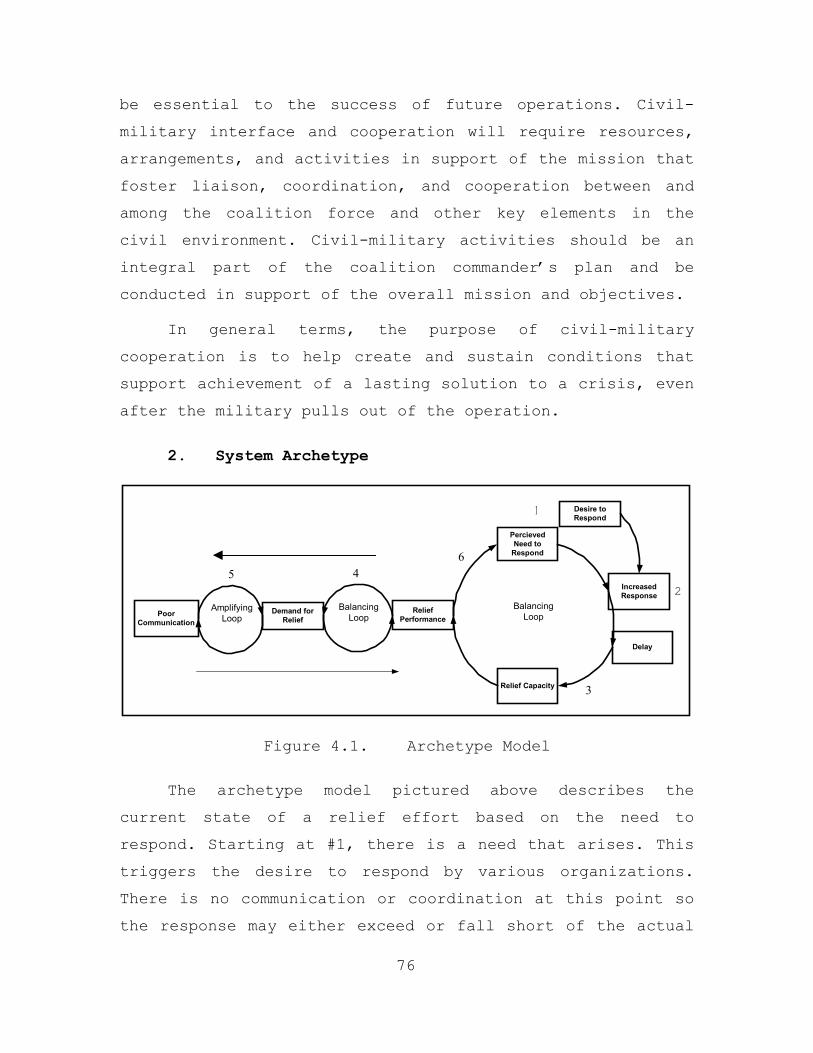
be essential to the success of future operations. Civil-
military interface and cooperation will require resources,
arrangements, and activities in support of the mission that
foster liaison, coordination, and cooperation between and
among the coalition force and other key elements in the
civil environment. Civil-military activities should be an
integral part of the coalition commander’s plan and be
conducted in support of the overall mission and objectives.
In general terms, the purpose of civil-military
cooperation is to help create and sustain conditions that
support achievement of a lasting solution to a crisis, even
after the military pulls out of the operation.
2. System Archetype
PoorCommunication
ReliefPerformance
Demand forRelief
PercievedNeed to
Respond
IncreasedResponse
Relief Capacity
Desire toRespond
Delay
AmplifyingLoop
BalancingLoop
BalancingLoop
1
2
3
45 6
Figure 4.1. Archetype Model
The archetype model pictured above describes the
current state of a relief effort based on the need to
respond. Starting at #1, there is a need that arises. This
triggers the desire to respond by various organizations.
There is no communication or coordination at this point so
the response may either exceed or fall short of the actual
76
need. All we know is that by #2 the level of effort has
increased from where we started at #1. At #3 there still
hasn’t been any coordination and this is coupled with any
delay it may have taken in responding to the initial need
at #1. The situation can be exacerbated at this point if
there is a perception the need is not being met and the
call will go out again asking for organizations to respond.
At #4 we see the level of relief capacity providing a level
of relief performance balanced against the current demand
for relief support. If the capacity to respond matches the
demand in both scale and quality, then performance will be
acceptable. The demand, capacity and level of performance
all depend on the communication channels available shown at
#5. These communication channels are the critical link and
essential to coordinating the need with the response, the
demand to the capacity and ensuring an acceptable level of
performance. The quality of this communication will
determine how well the needy are helped and how efficient
and timely an organization’s response will be. Currently,
the communication process in a CHE is not sufficient to
always meet an acceptable level of performance and results
in inefficiencies and unfulfilled needs. By the time we
get back to #6 no one has a clear understanding of what has
been met and what hasn’t. This can result in redundant
efforts or worse yet a need that receives no response at
all.
3. Proposed Solution
In light of the information presented in the previous
section, there needs to be a change in the mindset of the
organizations involved in CHEs. The interaction between the
CHE participants is unstable at best and needs to be
77
improved. A recommended solution that could assist in the
humanitarian assistance realm is an open system model
diagramming the preferred environment. This model will be
helpful in understanding the environment and may encourage
all the organizations involved to initiate an internal
change to work together in a synergistic fashion. In
addition, we believe that the creation of a habitat would
aid in restoring trust and confidence among the CHE
participants, and encourage communication between all the
organizations.
A habitat is a dynamic virtual construct that allows a
set of collaborating components to come together and form a
team to solve a specific problem. The habitat resides
within the global information grid (GIG), using smart
information exchange infrastructure technologies, to
facilitate the intelligent tailoring and dissemination of
knowledge. Simply networking components together does not
create a habitat. Components must be able to share
resources (information, services, etc.) in a way that
optimizes their ability to carry out their assigned tasks
effectively within constraints imposed by security or
policy. A habitat is dynamically created to support a
specific operational mission. It interfaces with other
habitats as well as all other “legacy” systems, assets,
organizations, or individuals (equipped with a compatible
interface or “wrapper”). In order to do this effectively,
every habitat uses a “Habitat Specification (HSPEC)” to
identify itself, present its credentials, and describe its
information requirements and contributions. When enabling a
new habitat, a “HSPEC” is automatically formed. The HSPEC
identifies:
78
• The role, or job, of the habitat (based on policy
and doctrine)
• Parameters that are important for determining the context in which the habitat is operating
• The security levels, policies, and rules associated with that role
• The physical characteristics (hardware, operating system, communications capabilities, etc.)
• The resource requirements based on the problem or task at hand, potentially tied to formal (machine interpretable) representations of the workflow being executed goal. (38)
H. NETWORK-CENTRIC INFRASTRUCTURE FOR COMMAND, CONTROL
AND INTELLIGENCE (NICCI) HABITAT CORE CAPABILITIES
The focus of Defense Advanced Research Projects Agency
(DARPA) NICCI is to quickly assemble habitats that
seamlessly integrate ad hoc components into an effective
task force. This is especially challenging and critical
when conducting coalition and CHE operations. NICCI will
provide the commander with the tools and capabilities
necessary to monitor component performance with regard to
the integrated processes and the desired end state. The
NICCI approach will be used to provide the information
exchange infrastructure for the habitat. Additionally,
NICCI will facilitate the ability to coordinate and
implement solutions for disparate, distributed, task
oriented teams. The technologies that will enable the NICCI
approach are characterized by the following six core
capabilities: Dynamic Information Management, Dynamic
Policy Management, Dynamic Context Management, Dynamic
Trust Management, Dynamic Resource Management, and Dynamic
Reconfigurability Management. (38)
79
The habitat will incorporate a Dynamic Information
Management capability to share information among habitat
components in a seamless, interactive, and reliable manner
while enabling controlled interactions among and between
habitats, and the rest of the world. There are four major
software agents that will be used for the Dynamic
Information Management in the Tactical Humanitarian Relief
habitat. An agent will be used to accomplish each of the
following tasks: resource problem-solving; find, filter
and present information for users; provide services to
other agents to help them cooperatively solve complex
problems; and provide translational services between agents
using different standards, communications protocols,
languages, etc. Large-scale, cooperative teams comprised of
interacting agents from all four groups, could offer new
capabilities that are beyond the realm of current software
designers. An infrastructure that could provide these
capabilities would allow software developers to design
smaller pieces of code that would primarily function on
solving problems via interaction with each other, rather
than by each trying to duplicate functions provided by
others. (38)
The heterogeneous systems (Groove, ROCC AND VCMOC,
etc), separately developed, will be integrated into
compound systems at run-time, based on the needs of the
particular problems being solved. Finding these code pieces
would be enabled by yellow page servers using taxonomies of
common functionalities. Where gaps might exist between the
agents, functions such as translation services could
provide greater interoperability by seamlessly filling in
the pieces. Members of the habitat will be able to program
80
and interact with their agents using interface tools that
would allow them to set preferences and describe needs
without needing to specify algorithmic details. In
addition, the entire GIG of cooperating agents could be
managed by the brokering agents – which would help to
manage the efficient flow of information across the grid.
These agents could also provide tools for access control
and information security, and they could provide a database
allowing post hoc analysis of problem solving and other
grid management services.
The habitat will contain a Dynamic Resource Management
capability that is responsible for building a list of key
habitat parameters that will communicate to other habitats
its purpose, authority, current status, and available
resources. This capability will also coordinate with
Dynamic Context, Policy, and Trust Management capabilities
to generate and maintain the list of resource requirements
deemed necessary to accomplish the given objective. As
habitat memberships are established, this capability will
manage the resource requests both from the local habitat to
connected habitats, and vice versa.
Members of the habitat will be able to setup queries
to search and filter large knowledge databases, to search
through the net or other information sources, or to find
computational resources needed for the problems they were
trying to solve – all without needing to know the details
of the underlying systems or information repositories.
Current "legacy" systems will be brought to the grid
through software wrappers and service descriptions,
allowing their functionality to be tapped without major
recoding. In addition, the cooperative nature of the
81
problem solving, using existing software components, would
allow both military and industrial users to continue to
develop large scale applications without large scale
software development efforts. (38)
The habitat will incorporate a Dynamic Policy
Management capability to help keep the conflict of rules
between all the habitat members to a minimal. At the
field/tactical level, communication between the NGOs and
IOs is often uncoordinated and/or nonexistent leading to
shortfalls, friction and redundancy of effort. As the
military footprint is established a U.S. sponsored joint
task force (JTF) or some multinational force, the
communication gap often widens between all participants.
One reason for this communication gap is the distrust of
the military by the NGOs and IOs. These organizations
operate simultaneously in theater, each with their own
organizational agendas, priorities, and structure. The
habitat will incorporate a Dynamic Policy Management
feature to help overcome this problem. (38)
The habitat will incorporate a Dynamic Context
Management capability to the ability to understand the
processes and resources needed to accomplish the task under
different environmental conditions. Different contexts may
require the adoption of different authority and
accountability relationships, dynamic task workflow or
priorities, needed and available information assets,
ontologies, and information processing services. Once
enabled, the Dynamic Context Management capability will
generate a list of recommended habitat resource
requirements it needs to help accomplish its mission. After
generating the list, it will coordinate with Dynamic Trust
82
Management to connect to those available and relevant
habitats. It will coordinate with Dynamic Information
Management and Dynamic Resource Management. (38)
The habitat will incorporate a Dynamic Trust
Management capability to establish and maintain the trust
relationships with other habitats, human, or legacy
components, as they become available and unavailable, and
making sure that only those components that are authorized
have access to local resources. Therefore, the capability
requires:
• Establishing and maintaining information
assurance policies and rules
• Establishing and maintaining chains of trust
• Incrementally establish trust relationships
• Maintaining trust relationships (including dealing with dynamic membership
• Negotiation to authorize access to new components
• Dynamically updateable
• Extend and revoke credentials across systems and networks
• Deal with both symmetrical and asymmetrical trust relationships
• Auditing mechanisms to support analysis, traceability, and accountability. (38)
As the habitat is established, the Dynamic Trust
Management capability will coordinate with Dynamic Resource
Management to get a list of habitats to connect to, and
then will coordinate with Dynamic Policy Management to
automatically establish trust relationships with those
habitats. (38)
83
The CHE environment is dynamic with quickly changing
operations, hardware and software moving, connecting and
disconnecting, and bursty bandwidth availability. Dynamic
Reconfigurability will exist in the habitat to monitor and
analyze the health of the habitat, adjust resource
availabilities, and usages appropriately to ensure that the
habitat performs productively. This will allow the habitat
group and their relationships to change over time. Dynamic
Reconfigurability is basically a life cycle management
capability that will enable habitats to automatically react
to changes in tasking, policy, and authority, as well as
failures, faults, and attacks. Causes for these types of
changes may be due to changes in the habitats goals and
objectives, tasking or command structure, configuration of
forces, situational context, and availability of resources,
temporary network or processor failures or faults, or total
loss of resources. Therefore, this capability requires
features that allow the habitat to self-heal, self-organize
(i.e., dynamic recruiting and shedding of resources), self-
configure, and provide an overall damage tolerance
capability. (38)
I. HABITAT COMPONENTS
The first component to fulfill the construct
requirements of the Tactical Humanitarian Relief Operations
habitat is a collaborative tool called “Groove.” A Groove
Workspace is a virtual space for small group interaction.
In a Groove Workspace, users make immediate and direct
connections to perform a wide variety of activities – from
working on a project, brainstorming, planning an event,
discussing issues, sharing drafts and proposals,
coordinating schedules, to just getting stuff done. This is
84
all done using a networking technique called peer-to-peer
(P2P). The essence of P2P is establishing a direct
connection between people, so IT isn't necessarily
involved. There are tools in the Groove Workspace that
facilitate the sharing of content (files, images, maps),
conversations on that content (discussions, instant
messages, live voice, text-based chat), and working
together on shared activities (real-time co-editing and co-
viewing of documents, co-browsing, group project management
and tracking, meetings management). By bringing these tools
together in a single construct, the Groove Workspace
streamlines work and communication so that teams can speed
up their decision-making and cycle time. (39)
Groove Workspace’s awareness capabilities promote
serendipitous as well as planned collaboration. Each shared
space shows the online status of all members, so that when
two or more members ‘find’ themselves in the same shared
space at the same time, they are able to quickly take
advantage of the situation and work together in real-time.
Likewise, a single user can glance at a single view of all
shared spaces to see if there are any ‘active’ members. The
ability to know who is currently and actively working on
certain projects is a new and powerful catalyst for
enhanced productivity.
While using Groove as the habitat’s construct program,
the second component of the Tactical Humanitarian Relief
Operations habitat are web-based applications called the
“Relief Operation Coordination Center” (ROCC) and "Virtual
Civil Military Operation Center" (VCMOC).” (37, 40) The
ROCC and VCMOC are technological tools that use central
HTML and Active Server Pages (ASP) to interface with a
85
database to insert, edit, view, delete and manipulate
information to enhance multi-participant communications and
the sharing of data. The application will improve the
overall dissemination of vital information leading to a
breakdown in communication barriers and a focus on mission
success.
The ROCC and VCMOC are designed to promote and support
better information transparency and exchange to reduce
operational security risks and avoid duplication of
efforts. It has the capability of keeping information on
organizations’ activities, plans, and resources available
and up to date. The ROCC and VCMOC will provide the
location for field assessments and databases to assist
planners, pre-deployment actors, implementers, and post-
crisis analysts. Furthermore as a web-based application, it
is mobile and accessible with Internet connectivity. The
main reason that the ROCC and VCMOC is embedded in Groove
is to enhance the ability of geographically distributed
users' to plan, organize, and team up for problem solving.
The following system requirements and capabilities
have been identified to allow a common, neutral
collaboration interface:
• A listing of the organizations and their mandates
involved in the relief effort
• Points of contact for organizations involved in the relief effort including a listing of the skills, supplies and number of people being provided by each organization
• The capability to manage displaced persons, tracking home of origin, current location, family members, and medical condition
86
• The ability to search a database to locate specific organizations, points of contact, needs and requirements or displaced persons.
• Timely and accurate situational awareness information concerning the history, current situation and projected situations for the relief area to include danger areas, infrastructure, safe areas, access routes, media contacts, local authorities and maps
• A tool to better coordinate and communicate between NGO and military units involved in the relief operation
• Awareness of logistical needs such as medical, food, shelter and clothing supplies. Where they are needed, when and how much
• Mobile capability provided by the use of wireless and handheld technologies. (41)
The ROCC and VCMOC has built in reports, queries, and
database search options using SQL statements (manipulate
and categorize the raw data) to provide useful information
for decision support and situational awareness to the end
user. Online meetings, discussions, document sharing and
editing, planning and executing of operational issues such
as personnel and materiel movement and delivery are
possible with the application. Using the mobile technology
(wireless devices, laptops, and handhelds) IOs, NGOs, and
military units involved in relief operations will have the
capability to communicate and coordinate with one another.
This communications occurs despite the physical distances
that may separate the members of the habitat and the lack
of an established telecommunications infrastructure.
The ROCC and VCMOC is a tactical/field level
operational support tool. It is highly mobile, rapidly
deployable, and able to interface with a larger more robust
87
system once the CHE reaches a more mature stage. The ROCC
and VCMOC will be assessable through the Internet or the
web browser feature of Groove. By using the ROCC and VCMOC
within Groove, the members of the habitat will be able to
self organize. Having situational awareness of each other
and the current status of the relief effort, the habitat
members will experience an unprecedented environment that
will allow the IO/NGO/military to work together and focus
more of their efforts on helping people in need vice
communicating.
1. Habitat Nodes and Sensors
A node is a connection point, either a redistribution
point or an end point for data transmissions. Additionally,
a node has programmed or engineered capability to
recognize, process or forward data or information to other
nodes. The most popular node in the Tactical Humanitarian
Relief Operations habitat is the computer. Computers will
be used to send emails, instant messages, and voice over
Internet protocol (IP), send files, and search the
Internet. Ubiquitous computing will come in many shape and
forms in this habitat. The members of the habitat will have
laptops, client/server workstations, personal display
assistants (PDA), and pocket computers (PC). Though the
technology resident in PDAs and pocket PCs is limited when
compared to a laptop or workstation, these computers still
allows users to conduct basic functions such as send
emails, instant messages, send files and search the
internet. The computers that are used in the habitat will
utilize a telephone line, a fiber optic cable, or a
wireless network infrastructure.
88
Another node in the habitat is a ruggedized portable
integrated communications system called the TAC-PAK. This
system is a lightweight, battery powered, man portable
communication system with full wireless communications
functionality integrated into a small suitcase. Personnel
operating in remote locations will have full communications
capabilities available to them anywhere (back seat of a
car, picnic bench, emergency site, etc). The TAC-PAK was
developed for emergency incidents in the field. Available
options in the battery powered and modular TAC-PAK system
include an environmentally secure carrying case, Pentium
laptop computer, three simultaneous RF data lines, color
printer, fax, copier, digital still/video camera with voice
annotation, document scanner, cellular telephones,
satellite telephones, GPS system, GIS system, television
receiver, and video conferencing. Although the TAC-PAK was
researched, it was not used due to its limited bandwidth
utilizing the INMARSAT system. The availability of the NASA
ACTS satellite system provided the bandwidth desired for
this project. (42)
NASA Advanced Communications Technology Satellite
(ACTS) is the third node in the habitat. ACTS was developed
as an experimental on-orbit, advanced communications
satellite test bed, bringing together industry, government,
and academia to conduct a wide range of technology,
propagation, and user application investigations. This
satellites operations in the Ka-band radio spectrum (30/20
GHz) where there is 2.5 GHz of spectrum available for use —
five times that available in lower frequency bands. The
ACTS network is comprised a variety of terminal types. Two
general categories of terminals were developed: fixed and
89

mobile earth stations. We will be using one of the mobile
earth stations that were loaned to NPS for research. The
ground station is called the Ultra Small Aperture Terminals
(USAT) are similar in size to direct broadcast television
terminals. The USAT can provide uplinks as fast as 1.5 Mbps
as well as downlinks to 45 Mbps. The primary use of the
ACTS/USATs in the habitat is for high speed Internet
service and real-time video conferencing. (43)
The fourth node/sensor and the most important in the
habitat are the habitat members. A sensor is normally a
device that feeds raw data values into one or more systems.
Physical sensors that provide the raw data vary in quality,
reliability, and the extent to which their values must be
filtered and combined with others to obtain useful
information. A sensor might be as simple as a software
switch recording the fact that a pilot turned on an
instrument or as complex as an Air Data Computer that
reports a number of atmospheric measurements. Humans have
built in sensor capabilities too. For example, when a CHE
participate inputs to the system (e.g., manually entered
position coordinates) he or she also plays the role of
sensor data or information provider.
The primary role of the user will be to provide the
cognitive and analytically knowledge required to accomplish
the requirements of the habitat. Agent technology will be
used to take sensor input from habitat members and Global
Positioning System (GPS) receivers to match resources with
requirements. However, the maturity of agent technology is
years from replicating complicated requirements that
90
requiring thinking outside of certain rule set. The ability
of humans to learn is unparallel to the capabilities of
agents to do so today.
The only equipment sensor that will be used in the
Tactical Humanitarian Relief Operations habitat is a GPS
receiver. GPS is the only system available today that shows
you your exact position on the Earth anytime, in almost any
weather condition, anywhere. GPS satellites, 24 in all,
orbit at 11,000 nautical miles above the Earth. They are
continuously monitored by ground stations located
worldwide. The satellites transmit signals that can be
detected by anyone with a GPS receiver. Using the receiver,
you can determine your location with great precision.
Members of the habitat who are operating in a tactical or
field environment can navigate in their area of operation
and provide position location reports to the other members
of the habitat through the use of a GPS receiver can be
inserted into a pocket PC or laptop computer. There are
several commercial GPS programs that are available for use
on the pocket PC or laptop computers. (44)
2. Habitat Taxonomy
91
A space populated by collaborative technologies is
called the T-Space. Each individual groupware product or
technology is represented by a point in this large space.
Categories of similar technologies are represented by
regions in the space, which is the framework. Taxonomies of
groupware systems are usually based upon same/different
time/place and areas of application. In this paper, we
will use the keeper coordinator communicator agent (KCCA)
aspects model, which is a classification based upon
categorization of groupware according to its T-Space
functionality. The first aspect, keeper, groups all
functionality that is related to storage and access to
shared data. The second aspect, coordinator, is related to
the ordering and synchronization of individual activities
that make up the whole process. The third aspect,
communicator groups all functionality related to
unconstrained and explicit communication among the
participants. (44)
There are many examples of keepers in the Tactical
Humanitarian Relief habitat. One example is the ROCC and
VCMOC. This application contains a specialized database of
artifacts that can be shared in P2P and/or client/server
network architecture. It allows multiple users to
simultaneously access the camp diagrams, task and resource
requirements, and points of contact information. When used
in the Groove construct, it also allows the habitat members
to systematically track the work of others. An example of a
keeper feature in Groove is called access control - (who
has access to what, and who is allowed to change this
access?). The owner of the shared workspace in Groove has
the ability to set permissions of the members of the space.
Additionally, Groove has an awareness feature in its
document section that gives versioning, time-stamping, and
change agent information.
Sometimes the emphasis of a group is not on artifacts,
but on activities that must be performed in a specific
order to fulfill certain group goals. The calendar and task
features of Groove demonstrate the coordinator components
of the application. The application sends notification to
users that they may start an activity, or that an activity
is late. Agents imbed within the ROCC and VCMOC will assist
92
in the synchronization of steps in the process, execute
automatic activities, provide helpful data and
notifications, and keep track of important information such
as state of a job or process, and deadline dates. If
necessary, the agents will send reminders to critical
members of the habitat when deadlines are missed. For
example, let us say that a warehouse of grain needs to be
delivered to a camp. The task is posted in the requirement
section of the ROCC and VCMOC for visibility by all the
habitat members. Whoever can fulfill the requirement will
simply bring up the task and check the “I can fulfill”
checkbox under the requirement. Then an agent will notify
the habitat member that their requirement has been
fulfilled and by whom.
Communication is a basic aspect of any collaborative
endeavor. In a mainly keeper application such as a
database, there is implicit communication when one
participant changes the data and that is observed by the
others. In a mainly communicator application, there is
implicit communication when one participant finishes an
activity that enables other participants to start other
activities. But in many endeavors, there is also a need for
explicit communication among the participants. The
communicator aspect of Groove is electronic mail (text or
voice), instant messaging, voice over Internet protocol
(IP) for real-time communications and the awareness feature
that shows what habitat members are doing when the mouse
arrow is placed over their name or a section with the
workspace. On the other hand, the ROCC and VCMOC as a
standalone application only communicator feature is email.
93
3. Networking Platform
The networking platform for the habitat will be a
combination of Peer-to-Peer (P2P), client-server
communications, wired and wireless Local Area Networks
(LAN), and access to the Internet cloud. P2P will be used
to take advantage of fully distributing service
functionality among all nodes participating in the system
and routing individual requests based on a small amount of
locally maintained state. The goals extend much further
than just improving raw system performance: such systems
must survive massive concurrent failures, denial of service
attacks, etc. Client Server will be used to allow members
of the habitat to access information from the internet to
maintain a knowledge base and use the Groove applications,
which requires some client-server interaction for
establishing and locating users.
The P2P wireless collaborative network will be
comprised of mobile terminals (Pocket PC (iPAQ) with GPS
receiver and/or wireless laptop) with connectivity to wired
or wireless LANs. Access points will be distributed in the
area of operation to provide local area coverage and
routing functionality. Servers capable of handling
application and web request from clients and
uploading/downloading data via satellites or telephone
infrastructure capable will be used too.
J. AGENT TECHNOLOGY PLATFORM
Control of Agent-Based Systems (CoABS) is a program of
the U.S. Defense Advanced Research Projects Agency (DARPA)
to develop and demonstrate techniques to safely control,
coordinate, and manage large systems of autonomous software
94
agents. DARPA is investigating the use of agent technology
to improve military command, control, communication, and
intelligence gathering. CoABS will be used to bridge
different systems, because of its ability to wrap legacy
systems and interfaces to other components (or agents) and
legacy systems. This ability to work with other components
and legacy systems to accomplish complex tasks in flexible
teams instead of using a single monolithic application to
adapt to changes in the battle space, the task at hand, or
the computing environment is critical to the functioning of
the habitat. Groove will allow us to scale collaboration
communities involving people, systems, and databases. This
will support the requirements of the members in the habitat
to for an environment that improves their ability to share
and organize data, information, and knowledge in addition
to managing the interactions of the entities involved. (45)
The CoABS Grid is middleware that integrates
heterogeneous agent-based systems, object-based
applications, and legacy systems. It includes a method-
based application programming interface to register agents,
advertise their capabilities, discover agents based on
their capabilities, and send messages between agents. The
grid also provides a logging service, to log both message
traffic and other information; a security service to
provide authentication, encryption, and secure
communication; and event notification when agents register,
deregister, or change their advertised attributes. The
CoABS Grid features include flexible run-time
communications and dynamic registration and discovery of
relevant participants. It is adaptive and robust, with the
system evolving to meet changing requirements without
95
reconfiguring the network. The grid is only one part of the
overall CoABS program, the plumbing that connects the
legacy system components to solve real world problems.
Therefore, you can also think of the grid as this
infrastructure layer and all the agents and services
running on it. (45)
Currently, there is not a formal, unbiased,
technological based CHE or Peace Operations ontology or
operations support system in place that would facilitate
the sharing of data and information. The Tactical
Humanitarian Relief Habitat described in this chapter is
our recommended solution. This habitat was designed to
improve the overall dissemination of vital information
leading to a breakdown in communication barriers, less
organizational friction and redundancy of effort between
the IOs, NGOs, and military units.
96
V. DEVELOPMENT OF A TECHNICAL EVALUATION
A. INTRODUCTION
The research of this thesis thus far, has focused on
further development of a working prototype of a
collaborative and information sharing habitat designed to
support Civil-Military Operations (CMO) during a CHE. The
overarching intent is to take the technology of a
previously developed proof of concept (The ROCC), combine
it with the emergency site tactical communication platform
(NASA Advanced Communication Technology Satellite (ACTS)),
the NICCI Habitat concept, the functionality of the CMOC,
collaborative tools, wireless technologies, and a
situational awareness application and integrate them to
form a peer-to-peer, interagency, information sharing
habitat. This technical evaluation will seek to demonstrate
how the successful integration of these functionalities
will prove effective in facilitating information sharing
and collaboration by all organizations involved in a CHE.
Currently, there is not a formal, unbiased,
technologically based CHE ontology or operations support
system in place that would facilitate the sharing of data
and information (25) during a CHE. In order to facilitate
the efficient collection and dissemination of the
information relevant to a particular CHE, a robust,
reliable, and redundant communication architecture, that
provides universal access for all organizations involved,
is required. This fundamental requirement, however, poses a
challenge since every CHE is different in its composition,
organization and location. This is especially true in cases
of interoperating with the legacy equipment that is
97
utilized by many organizations (e.g. NGOs, IOs and Host
Nations). It is also true for those rural areas that have
no infrastructure due to a much lower subscriber density,
or areas with geographic challenges such as large bodies of
water, jungles, and mountainous terrain. Finally,
interoperability between multi national forces and requires
detailed coordination to facilitate effective
communication.
B. COMMUNICATION ARCHITECTURE
A communication architecture that is representative of
what would be used in a CHE environment will be utilized in
the design of this technical evaluation, however, this
architecture will be flexible and scalable in order to
accommodate the different environments in which a CHE may
occur. Wireless technologies will be examined in order to
take advantage of the reduced logistical footprint required
in wireless communication networks. Satellite
communications will also be utilized in order to
demonstrate establishing worldwide connectivity without
existing infrastructure. Furthermore, access to information
resident on a database through a web based application
utilizing these communications means will be demonstrated.
Figure 5.1 shows the diagram of the basic communication
architecture.
98
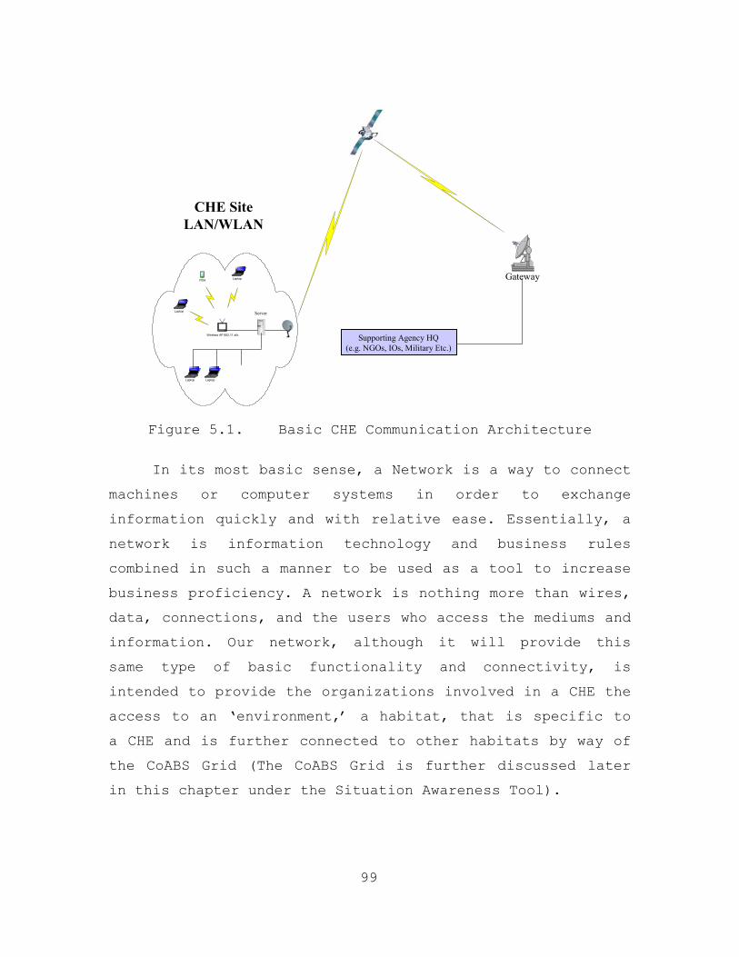
Laptop
Wireless AP 802.11 a/b
PDA
Laptop
CHE SiteLAN/WLAN
Server
Supporting Agency HQ(e.g. NGOs, IOs, Military Etc.)
Gateway
Laptop Laptop
Figure 5.1. Basic CHE Communication Architecture
In its most basic sense, a Network is a way to connect
machines or computer systems in order to exchange
information quickly and with relative ease. Essentially, a
network is information technology and business rules
combined in such a manner to be used as a tool to increase
business proficiency. A network is nothing more than wires,
data, connections, and the users who access the mediums and
information. Our network, although it will provide this
same type of basic functionality and connectivity, is
intended to provide the organizations involved in a CHE the
access to an ‘environment,’ a habitat, that is specific to
a CHE and is further connected to other habitats by way of
the CoABS Grid (The CoABS Grid is further discussed later
in this chapter under the Situation Awareness Tool).
99
1. Habitat Components
This section will discuss the different components
that provide the framework for the habitat that is being
presented and evaluated in this thesis. There are four
main components to the habitat; the Virtual Civil-Military
Operations Center (VCMOC), the Relief Operations
Coordination Center (ROCC), a Situational Awareness (SA)
tool, and a Collaborative Tool. These components, once
integrated with the network architecture, are the essence
the habitat.
a. Virtual Civil-Military Operations Center
(VCMOC)
Before discussing a ‘Virtual’ Civil-Military
Operations Center (VCMOC), it is appropriate to recall the
information about a CMOC discussed in Chapter II. The
Virtual CMOC concept is another cutting edge technology
project pursued by USPACOM and its resources. This program
is still at a very early stage. It is presented here
because it directly applies to our area of research and has
the potential to embody the concepts and findings presented
within this thesis.
The Virtual CMOC concept stems from the need to
maximize the availability of information to as many CHE
participants as possible. As mentioned above, the CMOC is
the U.S. Military’s principal field level coordinating
mechanism during Civil-Military Operations and CHEs. The
Virtual CMOC will focus on using technology and taking
existing information structures and looking for efficient
and rapid ways to digitally process and share the
information. This would enable critical information to be
accessible not just at the field level in a designated tent
100
or building, but at the operational and strategic levels as
well via a data network. This will also help integrate, and
more widely disseminate, key pieces of data. The framework
of the Virtual CMOC depends heavily upon the following:
• United Nations documents
• Local procedures
• CMOC policies, procedures, meeting schedules, agendas
• Reporting formats
• Other operation-specific references
The above information sources and processes will
help structure the core functionality of the Virtual CMOC.
Although much of the functionality for the Virtual CMOC is
still under development, there is a basic consensus of what
should be included based on research (46). Some of the
already agreed upon capabilities involve:
• Humanitarian tracking. The ability to provide a
database of who’s doing what where. This would enable operational planners, both military and civilian to focus effort and maximize resources.
• Assistance request and tracking. One of the main functions of the CMOC is to provide a place where civilian agencies can request assistance from military forces. The ability to process and track these request for assistance would be a vital function of the Virtual CMOC.
• Personnel locator. During an operation in response to a CHE, finding key personnel can be difficult in a chaotic environment. The Virtual CMOC would incorporate the ability to locate and perhaps contact key decision makers during a humanitarian response. (IBID)
101
b. Relief Operations Coordination Center (ROCC)
The one common denominator between each of the
participants in a CHE is the need for timely and accurate
information. The ROCC application is a dynamic. HTML-based
tool designed to enable these disparate organizations to
access and share relevant pieces of data synthesized and
made accessible through technology. This application has
the ability to provide a digital bridge by enabling these
organizations to collaborate, coordinate and share
information via web interface. This information might not
normally be shared due to differing mandates, cultures or
competition for funds. The ROCC application provides a
filter for these biases. Information is the currency and
its source is unimportant, as long as it is accurate and
timely and can be used to facilitate the relief effort.
The thesis will integrate the ROCC into a
network-based, collaborative environment that will allow
for improved coordination among agencies and organizations
that provide relief during and after CHEs. The integration
and further development of this application will increase
efficiency in providing relief, thereby reducing costs,
reducing spoilage, reducing redundancies and therefore
ultimately increasing the amount of people who may receive
the assistance. It is our belief that this application
will be cost effective since it requires the customer to
have only a web browser, and it will also contribute to the
saving of lives.
The ROCC has some of the functionality of the
intended Virtual CMOC, which once integrated into the
entire system, would provide a wealth of functionality for
users during a CHE. For example, The ROCC can provide a
102

database of who’s doing what and where they are doing it.
This enables operational planners, both military and
civilian, to focus effort and maximize resources. The ROCC
also has the ability to request for assistance. Assistance
requests and tracking is one of the main functions of the
CMOC. The ROCC provides a place where civilian agencies and
other organizations can request assistance from military
forces. The ability to process and track these request for
assistance is a vital function of the Virtual CMOC.
Additionally, the ROCC has a personnel locator function.
During an operation in response to a CHE, finding key
personnel can be difficult in a chaotic environment. The
ROCC incorporates the ability to locate and perhaps contact
key decision makers during a humanitarian response.
c. Situational Awareness Tool
Within the Department of Defense (DoD), shared
situational awareness (SSA) is generating a lot of interest
as a new paradigm for Command and Control (C2) and the
common operating picture at the small unit level. The U.S.
Defense Advanced Research Projects Agency (DARPA), Advanced
Technology Office (ATO) researches, demonstrates, and
develops high payoff projects in maritime, communications,
special operations, and information assurance and
survivability mission areas. The ultimate goal is superior
cost-effective systems the military can use to respond to
new and emerging threats. Currently ATO is working on a SA
project for small unit operations to provide mobile
communication system with high data-rate capacity that is
optimized for restrictive terrain (46).
103
In 2002, the Joint Futures Laboratory of the
Joint Forces Command (JFCOM) Joint Experimentation
Directorate and NPS conducted the Limited Objective
Experiment over a period of several months culminating with
a role-playing scenario 12-14 March 2002. SA is defined as
the real-time ability to acquire and process a host of
different data in a constantly shifting environment, and
the ability to translate an assessment into action aimed at
maintaining integrity (of self, of dependants, of mission)
– basically, SA is knowing what is going on around you and
adapting to it. Some of the objectives of the LOE were to
explore these key factors in SSA, determine the situational
awareness of the individual team members, the overall
generic SA of all teams (together), the SA of the en route
Supporting Area Commander, and the JFCOM headquarters in
Norfolk, Virginia.
In response to an interest in exploring SSA, a
web agent based application titled “CHE situational
awareness tool” was created to study SSA in the field
environment as it relates to CHEs. The purpose of the CHE
SA tool is to allow CHE participants to have SSA of each
other’s location and common knowledge of events in their
area of work. The tool is designed to use either the
Microsoft Internet Explorer or Netscape Navigator browser
as the graphical user interface (GUI). The user determines
which browser they will use to interface with the CHE SA
tool based on their preference for an Internet web browser.
Flash application is the technology that is used
to bring pictures and icons into the web browser in the CHE
SA tool. Flash is used to develop interactive animated
graphics for the SA Management Agent to display. This
application is bandwidth-friendly and has browser-
independent vector-graphic technology. Flash requires
104
Microsoft Windows as the operating system and the flash
plug-in has to be downloaded if a CHE participant doesn’t
have it as a standard feature with there web browser.
Within the CHE SA tool, Flash takes the input/output of the
agents through the sockets to work to support the display
functionality provided by the SA Management Agent.
The CHE SA tool exists in two different spaces at
the same time. The web server (client/server) is the first
space that is discussed. The client/server software
architecture was chosen for one of the spaces for the CHE
SA tool because it is a versatile, message-based and
modular infrastructure that is intended to improve
usability, flexibility, interoperability, and scalability
in networks. A single machine can be both a client and a
server depending on the software configuration. A major
advantage of making this tool a web-based application is
that clients do not have to download any software in order
to use it. Thus, the user gets the best of both worlds by
taking advantage of the benefits of client/server
architecture while not requiring clients to download or
purchase the CHE SA tool as an application. As long as CHE
participants can get network connectivity, they will have
access to the CHE SA tool.
The Control of Agent-Based Systems (CoABS) grid
is the second space that the CHE SA tool resides. CoABS, a
current program of DARPA, is designed to develop and
demonstrate techniques to safely control, coordinate, and
manage large systems of autonomous software agents. The
CoABS Grid is middleware that integrates heterogeneous
agent-based systems, object-based applications, and legacy
systems. It includes a method-based application-programming
105
interface to register agents, advertise their capabilities,
discover agents based on their capabilities, and send
messages between agents. The grid is only one part of the
overall CoABS program; it is the plumbing that connects the
components of legacy systems to solve real world problems.
Therefore, you can also think of the grid as an
infrastructure layer and all the agents and services
running on it. (45)
The CHE SA tool is a multiagent system that
consists of several software agents that perform a number
of functions. All of the agents reside on the CHE SA web
server. The first agent is called the GPS Tracking Agent.
This agent provides the input data to the SA Management
Agent. The data that the GPS Tracking Agent will collect to
supply to the SA Management Agent will come from a global
positioning system (GPS) receiver. If the CHE participant
is inside a building or does not have a GPS receiver, the
GPS Tracking Agent can accept manual inputs from the CHE
participant to provide location information to the SA
Management Agent.
The SA Management Agent is the second agent in
the CHE SA tool. This agent provides the visual interface
display for all CHE participants through their web browser.
This agent supports the SSA of all the users. The SA
Management Agent uses input from the Flash and the GPS
Tracking Agent to display the location of CHE participants
and significant events.
106
The CoABS Grid Agent is the third agent in the
CHE SA tool. This agent performs the liaison role between
the CHE SA tool and the CoABS grid. The CoABS Grid Agent
makes bridges to different systems, because of its ability
to wrap legacy systems and interfaces to other components
(or agents) and legacy systems. This allows the CHE SA tool
to use data from any database that is a part of the grid.
This approach was taken to overcome the challenges of
stove-piped legacy systems.
The Agent Database is the final agent in the CHE
SA tool. This agent is the manager of the database
repository for all the events that occur in the CHE SA
tool. For example, when a CHE participant wants to use the
CHE SA tool they will have to login to the tool via their
web browser. This login event along with all the actions of
the CHE participant in the CHE SA tool are captured and
stored by the Agent Database in a database.
d. Collaborative Tool
The potential of a network to take advantage of
“intellectual capital” has created a demand for
collaborative technology. The intent of collaborative
technology is to provide a medium within which people may
coordinate their individual activities regardless of their
location. This is a powerful capability; however
coordination of activities requires time for interaction.
Subsequently, one of the main focuses of collaborative
technologies is to provide a means of coordination that
requires little time but increases access to pertinent
information.
The collaborative tool this thesis has chosen to
utilize is ‘Groove.’ Figure 5.2. Groove is a decentralized
collaboration platform designed for peer-to-peer
interaction across technical and organizational boundaries
(such as firewall protected corporate LANs). Groove is
107
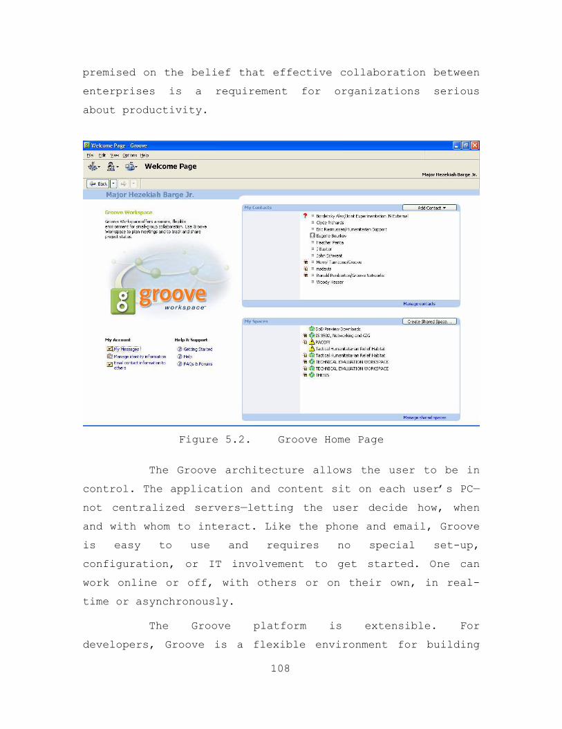
premised on the belief that effective collaboration between
enterprises is a requirement for organizations serious
about productivity.
Figure 5.2. Groove Home Page
The Groove architecture allows the user to be in
control. The application and content sit on each user’s PC—
not centralized servers—letting the user decide how, when
and with whom to interact. Like the phone and email, Groove
is easy to use and requires no special set-up,
configuration, or IT involvement to get started. One can
work online or off, with others or on their own, in real-
time or asynchronously.
The Groove platform is extensible. For
developers, Groove is a flexible environment for building
108
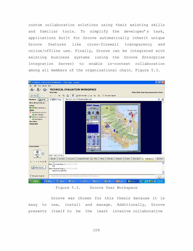
custom collaboration solutions using their existing skills
and familiar tools. To simplify the developer’s task,
applications built for Groove automatically inherit unique
Groove features like cross-firewall transparency and
online/offline use. Finally, Groove can be integrated with
existing business systems (using the Groove Enterprise
Integration Server) to enable in-context collaboration
among all members of the organizational chain. Figure 5.3.
Figure 5.3. Groove User Workspace
Groove was chosen for this thesis because it is
easy to use, install and manage. Additionally, Groove
presents itself to be the least invasive collaborative
109
application, thus addressing the potential reluctance, by
organizations normally involved in a CHE, of using a new
system.
2. NASA Advanced Communications Technology Satellite
(ACTS)
a. Background
The NASA ACTS communications system is the major
component in the communication architecture. This
communication system that provides the global connectivity
required for efficient CHE operations. The ACTS system is
made up of a spacecraft and a ground segment. The
spacecraft consists of a multibeam communication payload
and the spacecraft bus. The key technology components of
the communications payload are the multibeam antenna (MBA)
assembly, the baseband processor (BBP), the microwave
switch matrix (MSM), and Ka-band components. The spacecraft
bus houses the communications payload and provides attitude
control, electric power, thermal control, command
reception, telemetry transmissions, and propulsion for
station keeping.
The ground segment is comprised of the
spacecraft/communication network control stations and the
user terminals. A Master Ground Station located at NASA
Glenn Research Center (GRC) in Cleveland, Ohio transmits
commands to the satellite, receives all spacecraft
telemetry, and provides network control for all user
communications. As part of network control, it processes
and sets up all traffic requests, assigning traffic
channels on a demand basis.
110
A Satellite Operations Center was located at
Lockheed Martin Astro Space in East Windsor, New Jersey
(later transferred to the Lockheed Martin Communications
and Power Center facility in Newton, Pennsylvania in 1998)
connected to the Master Ground Station via landlines. It
has the prime responsibility for generating spacecraft bus
commands and for analyzing, processing, and displaying bus
system telemetry data. Orbital maneuver planning and
execution are also handled by the Satellite Operations
Center.
ACTS is a three-axis stabilized spacecraft
weighing 3250 pounds at the beginning of its on-orbit life.
It measures 47.1 feet from tip to tip along the solar
arrays and 29.9 feet across the main receiving and
transmitting antenna reflectors. The ACTS multibeam antenna
is comprised of separate Ka-band receive and transmit
antennas, each with horizontal and vertical polarization
subreflectors. The 7.2-foot, 30 GHz receive antenna
collects up linked signals, while the 10.8 foot, 20 GHz
transmitting antenna radiates downlink signals. Antenna
feed horns produce narrow spot beams with a nominal 120-
mile coverage diameter on the surface of the earth.
Fast (less than 1-microsecond), beam-forming
switch networks consisting of ferrite switches, power
dividers and combiners, and conical multiflare feed horns
provide sequential hopping from one spot beam location to
another. These hopping spot beams interconnect multiple
users on a dynamic traffic demand basis. A separate 3.3
foot, mechanically steered antenna, receiving uplink and
radiating downlink signals, is used to extend the ACTS
communication coverage to any location within the
111
hemispherical field of view from ACTS' 100 degree West
longitude position. Beacon signals at 20.2 GHz and 27.5 GHz
are radiated from two small, separate antennas.
b. NASA ACTS Program
ACTS was developed as an experimental on-orbit,
advanced communications satellite test bed, bringing
together industry, government, and academia to conduct a
wide range of technology, propagation, and user application
investigations. NASA Glenn Research Center awarded in
August 1984 the ACTS contract to an industry team
consisting of:
• Lockheed Martin, East Windsor, NJ for system
integration and the spacecraft bus.
• TRW, Redondo Beach, CA for the spacecraft communications payload.
• COMSAT Laboratories, Clarksburg, MD for the network control and master ground station.
• Motorola, Chandler, AZ for the baseband processor.
• Electromagnetic Sciences, Norcross, GA for the spot-beam forming networks.
The contract was awarded to RCA Astro Space of
East Windsor, NJ, which was subsequently acquired by
General Electric, and then by Martin Marietta (itself
acquired by Lockheed Aircraft Corporation in 1995 to become
Lockheed Martin). In 1988, as a result of a congressionally
mandated program funding cap, Lockheed Martin assumed
responsibility for completing the development of the
communications payload. Subsequently, Lockheed Martin (then
General Electric Astro Space) subcontracted with Composite
112
Optics, Inc. San Diego, CA for the manufacture of the
antenna reflectors and part of the bus structure.
(1) Launch. ACTS was launched as the
primary payload aboard the Space Shuttle Discovery (OV-103)
from the Kennedy Space Center, Pad 39B, as part of the STS-
51 mission on September 12, 1993. At launch and for
insertion into its geosynchronous orbit, ACTS was mated to
the transfer orbit stage component (TOS) for a total weight
of 6108 lbs.
(2) Orbit. ACTS was stationed at its
designated geosynchronous orbit location at 100 degrees
west longitude. In July 1998 the spacecraft's north/south
station keeping was stopped to extend operations in an
inclined orbit. In August 2000, the satellite was moved to
105.2 W longitude to be permanently located.
(3) Experiments. Experimental studies began
twelve weeks after ACTS was deployed. The communications
payload has continued to operate flawlessly 24 hours per
day, seven days per week, year round. The only periods of
"down time" occur during parts of the spring and fall
equinox periods when the ACTS’ solar panels are eclipsed.
Experimentation supported by ACTS continued until June
2000. In May 2001, the Ohio Consortium for Advanced
Communications Technology began using ACTS for educational
research. It is through this consortium that NPS, and
subsequently our thesis team, has gained access to this
system (43).
113
c. Ground Station Parameters
NPS has what is called an Ultra Small Aperture
Terminal (USAT). The USAT is similar in size to a direct
broadcast television terminal, however, equipped with a 60
cm antenna, it can provide uplinks as fast as 1.5 Mbps as
well as downlinks to 45 Mbps. Our desired application for
USAT is high speed network access and global connectivity.
d. Ground Station Architecture
The USAT ground station is modular in design for
easy configuration and integration. Consisting of five
major subsystems, the ground station is easily assembled,
operated and serviced. The five USAT subsystems are the
following:
• The antenna (60 cm).
• The combined low noise receiver/down converter.
• The combined up converter and solid-state power amplifier.
• The intermediate frequency up converter.
• The oscillator subsystem.
3. Network Management
114
Because this architecture involves utilizing a
Wireless LAN (WLAN), and more specifically, a WLAN in a
potentially remote environment as may be encountered in a
CHE, it was decided that wireless network management
procedures would be pursued and utilized. Therefore, this
thesis had to determine how to best manage a small wireless
network. This network consists of one Access Point (AP) and
up to 6 nodes. Our nodes are laptop computers configured
with wireless adapters and Personal Digital Assistants
(PDAs) with wireless cards. This allows us to see how
effective network monitoring and subsequent management
works on different end user devices. The proposed Network
Operations Center (NOC) is simply a combination of a
management station (laptop CPU) and a PDA configured with a
network management tool.
a. Network Operations Center
For network managers, the intent is to gain
enough knowledge about the network to effectively manage
it. To start, we want to know what nodes are accessing the
network through the wireless access point. This
information allows one to see if any unauthorized users are
accessing the network and also allows us to maintain the
best possible network accessibility for authorized users.
The network management tools we decided to utilize for
managing our network are SolarWinds and Air Magnet.
(1) SolarWinds. SolarWinds has several
network discovery tools that allow a manager visibility of
what nodes are accessing a particular wireless access
point, monitor hundreds of devices and keep track of
response time and packet loss. The SolarWinds Network
Monitor package can also send pages or E-Mails when a
device stops responding. SolarWinds also has a tool that
scans a range of IP address and looks at the Domain Name
Service (DNS) information to determine if users are
actually logging on to a network. Any errors found during
the scan will be highlighted. Managers can also filter the
results to show the reverse DNS errors, the IP addresses
that did not resolve or forward DNS errors. Another
SolarWinds tool can do network performance monitoring. This
115
tool is a real-time network monitor that can track network
latency, packet loss, traffic and bandwidth usage
In addition, the CISCO wireless access point
(AP) used in the network has a proprietary protocol
associated with it that allows one to see what we wanted to
see. This is called ‘CISCO Discovery Protocol.’ By simply
typing in the IP address of the AP in a web browser, a
manager can gain access to the Management Information Base
(MIB) information, Media Access Control (MAC) addresses and
limited traffic information about the desired nodes of
interest. This is what is desired for effective network
management. The information extracted from the CISCO
software used in conjunction SolarWinds provides a powerful
management tool. SolarWinds network monitoring applications
take the information from the CISCO software and monitor
the network much more efficiently then with either tool
alone. The combination of the two software tools provided
powerful network management ability.
Since our network was relatively small, we
liked this tool because we simply plugged in the IP
addresses of interest, collected with the CISCO protocol,
and the application alerted us when there was a potential
problem and allowed us to investigate further. The
response time of each device is monitored and when response
time begins to deteriorate or the device begins dropping
packets, a light beside the device turns yellow or the
light turns red if the device stops responding (47).
116
The SolarWinds application, used in
conjunction with the CISCO discovery protocol, provides us
as managers some useful methods by which to manage the
network, but these tools are not all inclusive with regard
to functionality. We need to collect more information and
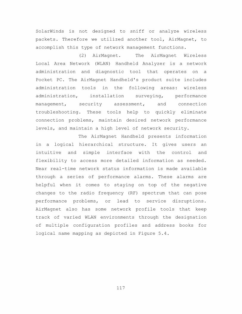
SolarWinds is not designed to sniff or analyze wireless
packets. Therefore we utilized another tool, AirMagnet, to
accomplish this type of network management functions.
(2) AirMagnet. The AirMagnet Wireless
Local Area Network (WLAN) Handheld Analyzer is a network
administration and diagnostic tool that operates on a
Pocket PC. The AirMagnet Handheld's product suite includes
administration tools in the following areas: wireless
administration, installation surveying, performance
management, security assessment, and connection
troubleshooting. These tools help to quickly eliminate
connection problems, maintain desired network performance
levels, and maintain a high level of network security.
The AirMagnet Handheld presents information
in a logical hierarchical structure. It gives users an
intuitive and simple interface with the control and
flexibility to access more detailed information as needed.
Near real-time network status information is made available
through a series of performance alarms. These alarms are
helpful when it comes to staying on top of the negative
changes to the radio frequency (RF) spectrum that can pose
performance problems, or lead to service disruptions.
AirMagnet also has some network profile tools that keep
track of varied WLAN environments through the designation
of multiple configuration profiles and address books for
logical name mapping as depicted in Figure 5.4.
117
Figure 5.4. View of All SSIDs with MAC Address.
The AirMagnet Handheld Analyzer helps
network managers stay on top of the performance curve, with
an Expert Performance Analysis Tool that monitors WLAN
networks and identifies the potential source of performance
problems as they are happening. This tool helps us to
identify any unauthorized access points that may be on the
network.
The addition of a WLAN introduces a whole
new class of threats for network security. Because of the
nature of RF signals (penetrate walls and extend beyond
intended boundaries), a WLAN is easily detectable and
potentially exposed to unauthorized users. In addition,
rogue APs that are not properly secured puts the entire
network at risk of outside penetration and attack. The
AirMagnet Handheld is designed to help defend against such
threats through the use of security tools that provide
alerts to more than 10 different threat conditions (48).
118
When it comes to network management,
AirMagnet provides the WLAN network operation center (NOC)
with a great ability to troubleshoot WLAN problems at the
layer 1-3 level. This is important because NOC staffs need
to be aware of what is occurring in the RF spectrum in
their work area.
C. TECHNICAL EVALUATION OF HABITAT FUNCTIONALITY
1. Scope of Evaluation
The Technical Evaluation (TE) will be conducted for
the Tactical Humanitarian Relief Habitat to see how well
CHE participants can collaborate and share information
locally or while geographically dispersed. The TE will take
place at Marine Corps Base Hawaii (MCBH). This location was
selected because it provided us with an environment that
simulated a CHE in a remote area and without an existing
infrastructure. Furthermore, going to MCBH would require us
to pack and ship all the equipment needed to create a
Tactical Humanitarian Relief Habitat. Additionally, the
NASA ACTS spot beam coverage includes Hawaii. Operators and
maintainers consist of the thesis team members and
Evaluation support personnel who are located at the Naval
Postgraduate School and the NASA ACTS support locations.
a. Evaluation Approach
119
The TE will be conducted with one KA-band
satellite ground station and its associated equipment, a
hub, web servers, laptops and PDAs (The laptops and PDAs
will serve as clients). The evaluation is designed to be
conducted over a three-day period. The TE is structured to
simulate a CHE environment to include at least one NGO/IO
and CMOC management personnel.
During the three-day period, we will examine
connectivity, the ability to access information via the
established network, the ability to collaborate, and
conduct a network analysis of data that is transferred
throughout the network. Evaluation personnel will operate
on an as required basis although the system will operate
continuously for the duration of the TE. Throughout the
three days, special events may be conducted at the
discretion of the thesis team for the purpose of adding
additional value to the evaluation.
The evaluation will commence with the
installation and initialization of the satellite ground
station equipment. The LAN will be established utilizing
wired and 802.11b wireless networking equipment. The
evaluation is based on two scenarios. These scenarios are
based on the establishment of a Tactical Humanitarian
Relief Habitat in a CHE environment and the participation
of the military/NGO/IO in the relief effort. The
information exchange is designed to simulate actual field
information exchange between involved organizations.
b. Evaluation Objectives
There is one overall objective for the technical
evaluation of this thesis. We will demonstrate
organizational (military/NGO/IO) communication between
dispersed habitat participants. The following Tactical
Humanitarian Relief Habitat technical evaluation objectives
were developed during the spring quarter of 2003 and
validated during the technical evaluation.
120
• Demonstrate intra-camp communication utilizing local area network technologies.
• Demonstrate global connectivity using a satellite system for reach-back communication.
• Conduct and analysis network management functions.
2. Schedule of Events
The first step in the TE is the installation of the
NASA ACTS satellite system. The NASA ACTS system consists
of four major components: the antenna assembly, mobile
ground station (MGS), satellite spacecraft, and the
satellite control station (located in Cleveland, OH). After
unpacking the equipment, the antenna assembly is the first
component that is put together. The antenna base is the
first to be assembled. The antenna dish hardware is then
mounted on the antenna base. Then the two vertical and
horizontal angle/azimuth antenna actuators are mounted on
the center section of the antenna/actuator mount. Next, the
dish is put on top of this mount followed by the antenna
high power amplifier/feed cone. The outdoor power module is
connected to the antenna’s high power amplifier/feed cone
through the use of three short cables that supply power,
and the capability to receive and transmit.
121
The antenna assembly is connected to the mobile ground
station (MGS) through the use of five cables (power,
receive, transmit, vertical, and horizontal actuator
control). All the cables are labeled individually and at
the interface connectors for both the antenna assembly and
MGS. The MGS is preconfigured for rapid deployment and use.
Inside the MGS, there is a component rack that holds two
routers, a computer, the antenna control module, the modem
and the AGC module (used for attenuation). The antenna base
must be leveled before the proper angle and azimuth can be
obtained. Once this is accomplished, power may be supplied
to the antenna assembly. Next you power up the rack and go
through the satellite acquisition SOP (see Appendix A).
Our experience in setting up the ground station is
limited and confined to acquiring a signal while at NPS.
This is a painful process at times because getting a signal
is not just a science, but an art as well.
Once an uplink and downlink signal has been acquired,
continue with the network connectivity troubleshooting. One
of the laptops should be connected to the MGS’s hub via CAT
5 cable and the hub should be connected to one of the MGS
routers. The NASA ACTS satellite has the capacity to uplink
data at 384 Kbps and downlink data at 2 Mbps. Connectivity
between routers can be verified through the use of the PING
function. We start by PINGing the internal router of the
MGS rack then subsequent routers outside the MGS rack.
Once network connectivity is established, then it is
time to start the scenarios. The first scenario simulates a
CHE participant conducting humanitarian relief efforts as a
member of the Tactical Humanitarian Relief Habitat. This is
done by the CHE participant accessing the VCMOC via the
established network and requesting a user identification
and password. The Tactical Humanitarian Relief Habitat
administrators will conduct a background check to validate
that the individual/organization that is requesting to join
the habitat is US or UN sanctioned. After the CHE
participant and their organization has been validated and
cleared for access to the habitat, the real work begins.
122
3. Evaluation Scenarios
The evaluation scenarios will be conducted in
accordance with Appendices B and C.
123

THIS PAGE INTENTIONALLY LEFT BLANK
124
VI. TECHNICAL EVALUATION RESULTS AND RECOMMENDATIONS FOR FURTHER RESEARCH
A. RESULTS OF TECHNICAL EVALUATION
1. NASA ACTS System
The NASA ACTS installation began with the assembly of
the antenna. A level piece of ground with a clear view in
the direction of the required azimuth and elevation was
selected and the antenna base was assembled and leveled.
The 60 cm parabolic dish was then attached to the antenna
base. The wave-guide and high power amplifier/feed cone
assembly was attached and the corresponding cables
connected between the amplifier and the outdoor power
supply box. The horizontal and vertical actuators were then
attached to the base and to the dish mount. The actuator
controller cables run to the antenna control module in the
mobile ground station (MGS) component rack. The 100’ radio
frequency (RF) cables were then connected between the
outside power supply box and the component rack (the
receive cable into the AGC box and the transmit into the
modem module).
125
The MGS component rack was placed inside the lodging
facility and the cables were appropriately connected. The
antenna assembly is connected to the MGS through the use of
five cables (power cable, receive and transmit RF cables,
and the vertical and horizontal angle/azimuth actuator
control cables). All the cables are labeled individually
and at the interface connector for both the antenna
assembly and MGS. The MGS is preconfigured for rapid
deployment and use. Inside the MGS there is a component
rack that holds two routers, a computer, the antenna
control module, the modem module and the attenuator (AGC)
module. Once all the cables were properly connected, power
was supplied to the MGS and the antenna. The final step is
to acquire the satellite, which was done according to the
satellite acquisition standard operating procedure (SOP)
(see Appendix A).
Our experience in setting up the ground station was
limited to acquiring a signal while at NPS. Fortunately,
this was a positive experience. We were able to conduct a
video teleconference, arguably the most bandwidth intensive
application, using the satellite as the communication pipe.
This success in the lab at NPS provided this thesis team
with the confidence and experience to conduct similar
operations once deployed to Hawaii. However, it was
discovered that the satellite acquisition process proved to
be a painful at times because getting a signal is not just
a science, but an art as well.
Before deploying the MGS to Hawaii, the team took the
appropriate planning steps to insure the proper angle and
azimuth was identified given the location in Hawaii. We
sent the latitude/long for our remote location to the NASA
ACTS Operations center and they subsequently gave us an
azimuth and elevation to acquire the signal. When we
arrived at the location (Monday, April 28 about 1600 local
Hawaii time) we began setting up the system. Using the
information provided by the satellite operations center, we
assembled the system and powered up and initially obtained
a signal (or so we thought). Unfortunately, we were never
able to get the required carrier lock. We spent countless
hours going through this painful process of trial and error
to try and obtain a signal. Troubleshooting, in the form of
126
phone conversations with Hans Kruse (Managing Executive of
the Ohio Consortium for Advanced Communications
Technology), Bruce Turry and Jeff Glass (Cleveland
Operations center), and John Graham (ACTS subject matter
expert), continued until Wednesday morning. It was at this
time that another Cleveland Ops employee, Dave, informed us
that the satellite has a 22 degree offset angle. This meant
that we had been aiming 22 degrees too high the whole time
and any signal we thought we were getting was simply noise.
The adjusted angle of 3-5 degrees now aimed us directly at
a sizable terrain feature, which completely blocked our
signal.
We went around the base on a site survey that morning
to determine if there was a viable location for us to move
the equipment. We found a site and made the coordination to
use it. We coordinated obtaining the cargo van to transport
the equipment and began the tear down procedures. We packed
and moved all the equipment to a site along our azimuth on
the other side of the terrain feature (mountain). As soon
as we finished set up, we obtained a signal and received
the actual frequency from the satellite (this is indicated
in one of the configuration windows of the modem). This
verified that we were actually hitting the satellite with
our signal and receiving a signal from the satellite.
However, we never obtained modem or carrier lock. All the
fault lights were off and the carrier lock light rapidly
flashed green but never locked and allowed us to send or
receive data. Thursday morning the decision was made to
shift all efforts elsewhere in the thesis and terminate the
efforts of acquiring the satellite.
127
2. Technical Evaluation Results of Scenarios
Scenario 1 in Appendix B was executed on an ad-hoc
wireless local area network (WLAN) that was setup at Marine
Corps Base Hawaii (MCBH). The purpose of this scenario was
to demonstrate the ability of a CHE participant to
effectively conduct humanitarian relief efforts within the
Tactical Humanitarian Relief Habitat. The scenario
consisted of three CHE participants in the Habitat
representing the following organizations: military civil
affairs, NGO and IO. Two of the CHE participants had a
laptop computer and one had a PDA configured to function on
an ad-hoc WLAN. Furthermore, the PDA user had a GPS
receiver.
The CHE participants worked in remote area of MCBH,
which contained a few buildings and basic services such as
running water, restrooms, electricity, and two telephones.
This was done to simulate a CHE working environment.
However, it was noted that some CHE environments during the
early phase of execution lack most of the basic services
listed in the previous sentence. The only reach-back
capability that the CHE participants had were cellular
phones and the two telephone lines that could be used to
make long distance calls and establish internet
connectivity at rates varying between 28Kbps and 45Kbps.
Prior to the start of the scenario, a few basic
assumptions were established. First, the NGO and IO
representative had already conducted the required
coordination for approval to join the Tactical Humanitarian
Relief Habitat. This would be accomplished via telephone
calls and emails based on the information provided on the
login page of the VCMOC. Previous CHE after action reports
128
have pointed out the importance of the need for preplanning
when it comes to NGO and IO who want to provide assistance
during a CHE. For example, during a Groove session on the
state of humanitarian affairs issues in Iraq, US Navy Cmdr
Eric Rasmussen, Deputy Health Minister for Iraq in the
Secretary of Defense Office of Reconstruction and
Humanitarian Assistance stated in April 2003 that there
were approximately 17 NGO/IO organizations in Iraq with
humanitarian supplies that were useless to the pending
needs. When these organizations arrive in country without
participating in any planning conferences for the CHE,
there is normally a great disparage in the logistic
coordination of matching up the critical needs at a
particular time with the proper resources. The VCMOC
registration process was designed specifically to deal with
this issue.
The second assumption is that all the members of the
habitat would have received the training and software
needed to be productive members of the habitat. The
components of the habitat were designed for non-technical
computer users. Two to three hours of training would have
to be conducted to give a new member of habitat a good
understanding of all the functionality that is resident
within the CHE SA tool, VCMOC and Groove. The only software
license that would have to be given to new habitat users is
Groove. The CHE SA tool GPS poster was developed at NPS and
does not require a license to distribute to habitat members
who desire to use GPS receivers for positional reporting.
Most of the executed tasks were based on the premise
of the habitat being a virtual environment in which the
members of the habitat could collaborate and coordinate
129
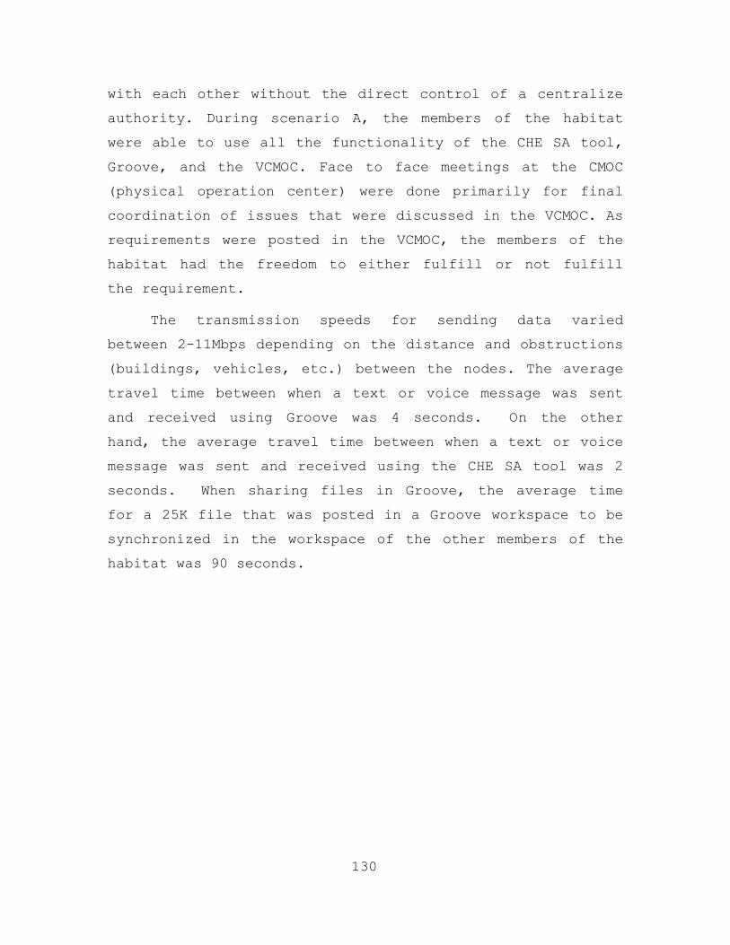
with each other without the direct control of a centralize
authority. During scenario A, the members of the habitat
were able to use all the functionality of the CHE SA tool,
Groove, and the VCMOC. Face to face meetings at the CMOC
(physical operation center) were done primarily for final
coordination of issues that were discussed in the VCMOC. As
requirements were posted in the VCMOC, the members of the
habitat had the freedom to either fulfill or not fulfill
the requirement.
The transmission speeds for sending data varied
between 2-11Mbps depending on the distance and obstructions
(buildings, vehicles, etc.) between the nodes. The average
travel time between when a text or voice message was sent
and received using Groove was 4 seconds. On the other
hand, the average travel time between when a text or voice
message was sent and received using the CHE SA tool was 2
seconds. When sharing files in Groove, the average time
for a 25K file that was posted in a Groove workspace to be
synchronized in the workspace of the other members of the
habitat was 90 seconds.
130
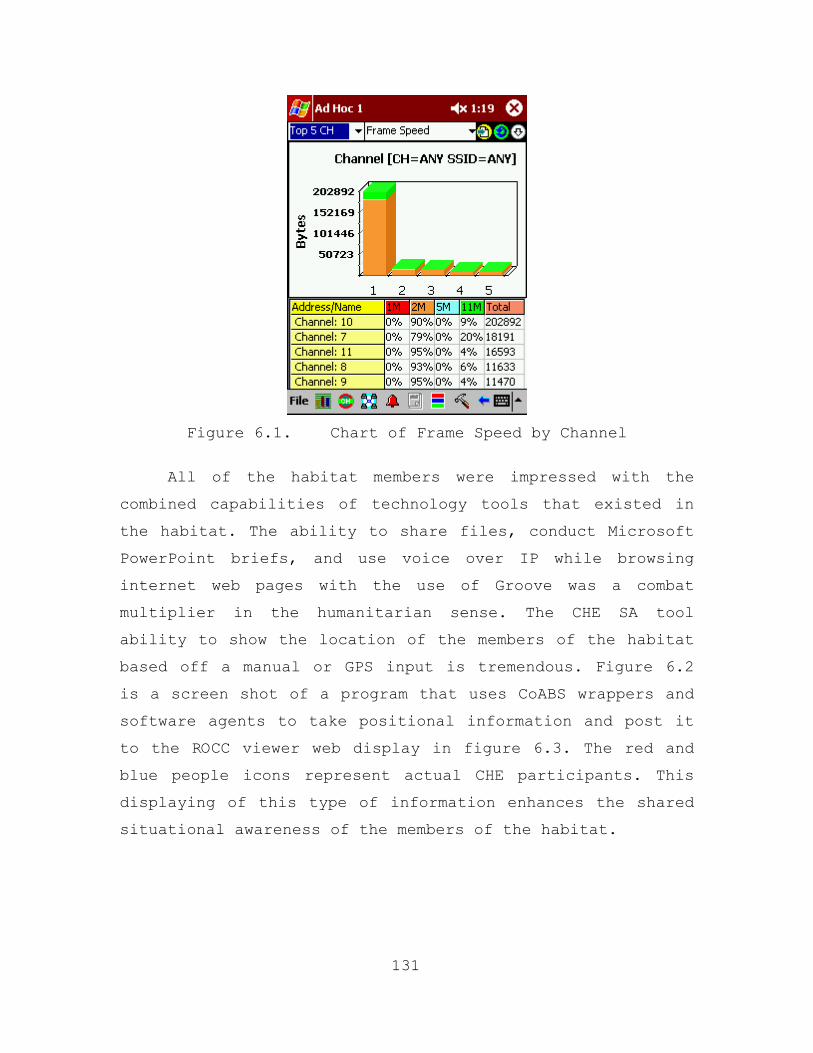
Figure 6.1. Chart of Frame Speed by Channel
All of the habitat members were impressed with the
combined capabilities of technology tools that existed in
the habitat. The ability to share files, conduct Microsoft
PowerPoint briefs, and use voice over IP while browsing
internet web pages with the use of Groove was a combat
multiplier in the humanitarian sense. The CHE SA tool
ability to show the location of the members of the habitat
based off a manual or GPS input is tremendous. Figure 6.2
is a screen shot of a program that uses CoABS wrappers and
software agents to take positional information and post it
to the ROCC viewer web display in figure 6.3. The red and
blue people icons represent actual CHE participants. This
displaying of this type of information enhances the shared
situational awareness of the members of the habitat.
131
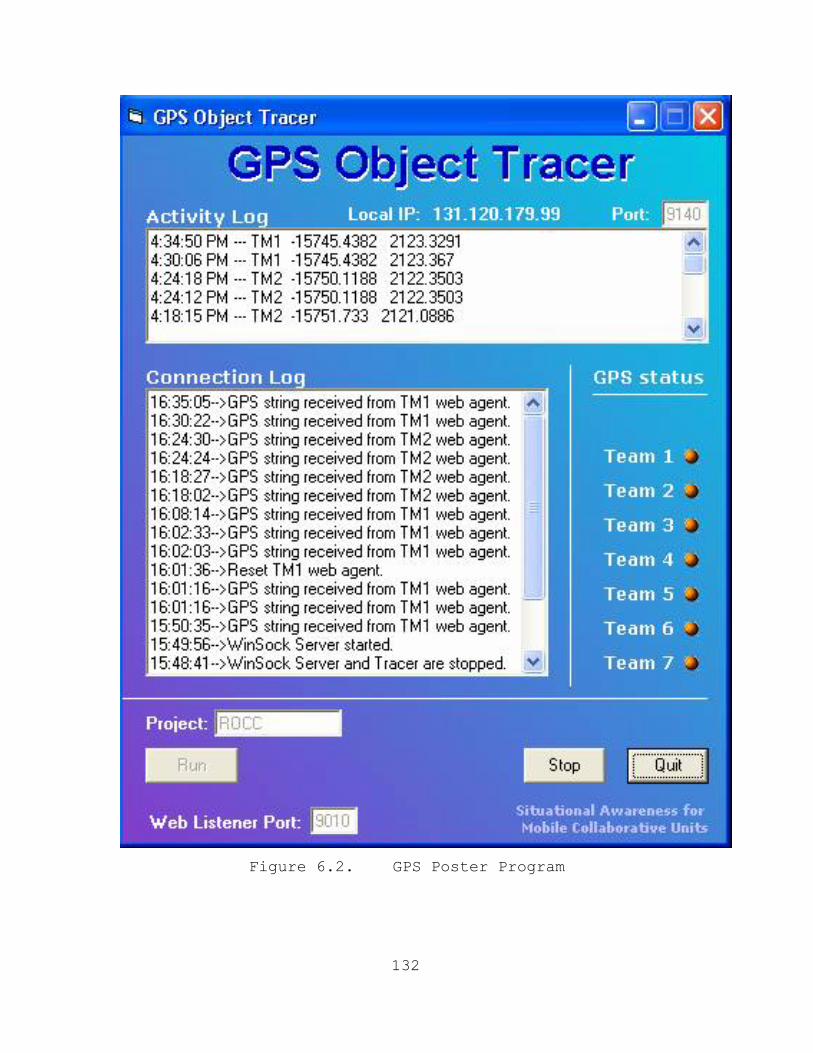
Figure 6.2. GPS Poster Program
132
Figure 6.3. CHE SA Tool Display within Groove
The next screen shot in Figure 6.4 is a visual
depiction of the CHE SA Tool in the Internet Explorer web
browser. Additionally, the red line between the people
icons (red and blue) shows that members of the habitat are
communicating with each other through the use of the text
messaging functionality embedded within the tool.
133
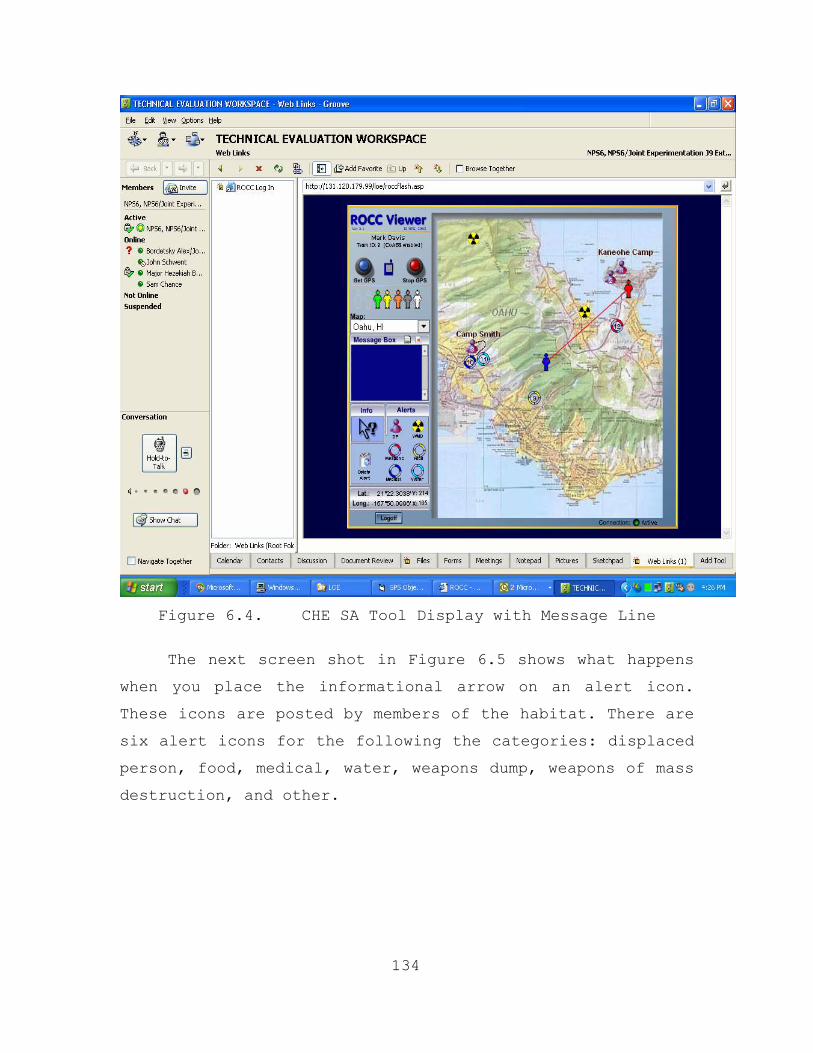
Figure 6.4. CHE SA Tool Display with Message Line
The next screen shot in Figure 6.5 shows what happens
when you place the informational arrow on an alert icon.
These icons are posted by members of the habitat. There are
six alert icons for the following the categories: displaced
person, food, medical, water, weapons dump, weapons of mass
destruction, and other.
134
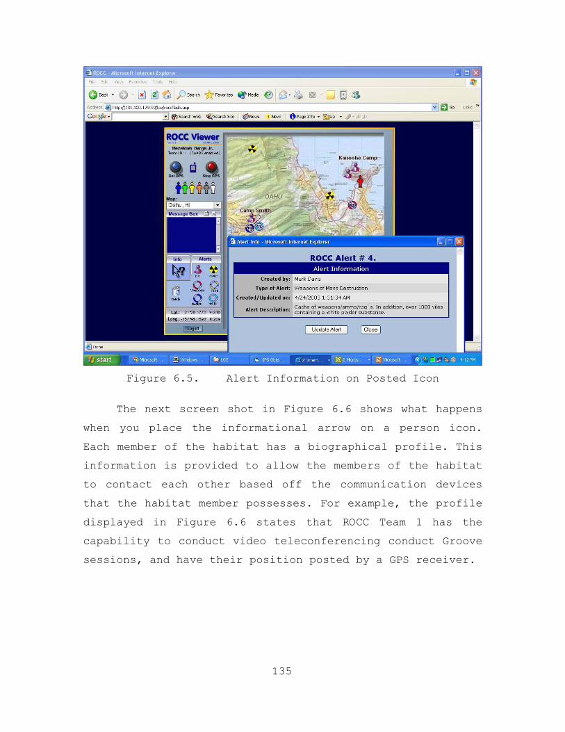
Figure 6.5. Alert Information on Posted Icon
The next screen shot in Figure 6.6 shows what happens
when you place the informational arrow on a person icon.
Each member of the habitat has a biographical profile. This
information is provided to allow the members of the habitat
to contact each other based off the communication devices
that the habitat member possesses. For example, the profile
displayed in Figure 6.6 states that ROCC Team 1 has the
capability to conduct video teleconferencing conduct Groove
sessions, and have their position posted by a GPS receiver.
135
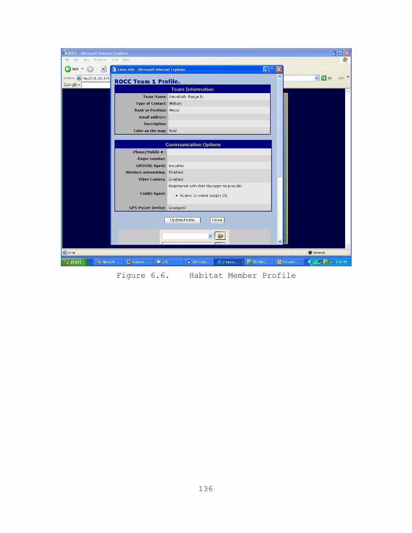
Figure 6.6. Habitat Member Profile
136
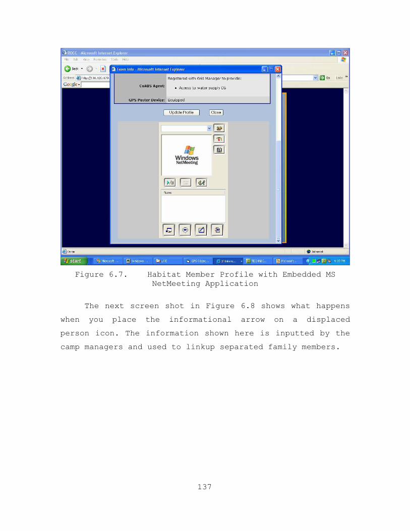
Figure 6.7. Habitat Member Profile with Embedded MS
NetMeeting Application
The next screen shot in Figure 6.8 shows what happens
when you place the informational arrow on a displaced
person icon. The information shown here is inputted by the
camp managers and used to linkup separated family members.
137
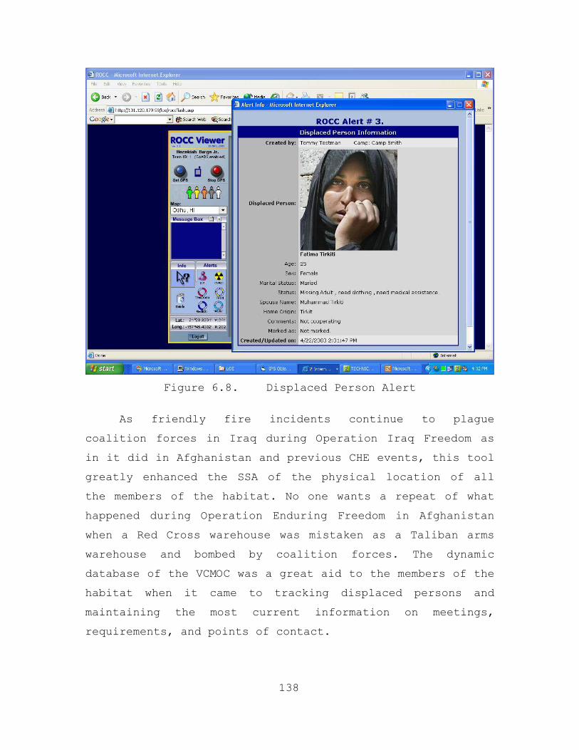
Figure 6.8. Displaced Person Alert
As friendly fire incidents continue to plague
coalition forces in Iraq during Operation Iraq Freedom as
in it did in Afghanistan and previous CHE events, this tool
greatly enhanced the SSA of the physical location of all
the members of the habitat. No one wants a repeat of what
happened during Operation Enduring Freedom in Afghanistan
when a Red Cross warehouse was mistaken as a Taliban arms
warehouse and bombed by coalition forces. The dynamic
database of the VCMOC was a great aid to the members of the
habitat when it came to tracking displaced persons and
maintaining the most current information on meetings,
requirements, and points of contact.
138
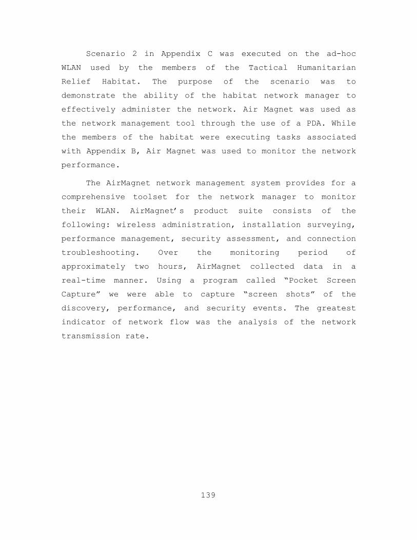
Scenario 2 in Appendix C was executed on the ad-hoc
WLAN used by the members of the Tactical Humanitarian
Relief Habitat. The purpose of the scenario was to
demonstrate the ability of the habitat network manager to
effectively administer the network. Air Magnet was used as
the network management tool through the use of a PDA. While
the members of the habitat were executing tasks associated
with Appendix B, Air Magnet was used to monitor the network
performance.
The AirMagnet network management system provides for a
comprehensive toolset for the network manager to monitor
their WLAN. AirMagnet’s product suite consists of the
following: wireless administration, installation surveying,
performance management, security assessment, and connection
troubleshooting. Over the monitoring period of
approximately two hours, AirMagnet collected data in a
real-time manner. Using a program called “Pocket Screen
Capture” we were able to capture “screen shots” of the
discovery, performance, and security events. The greatest
indicator of network flow was the analysis of the network
transmission rate.
139
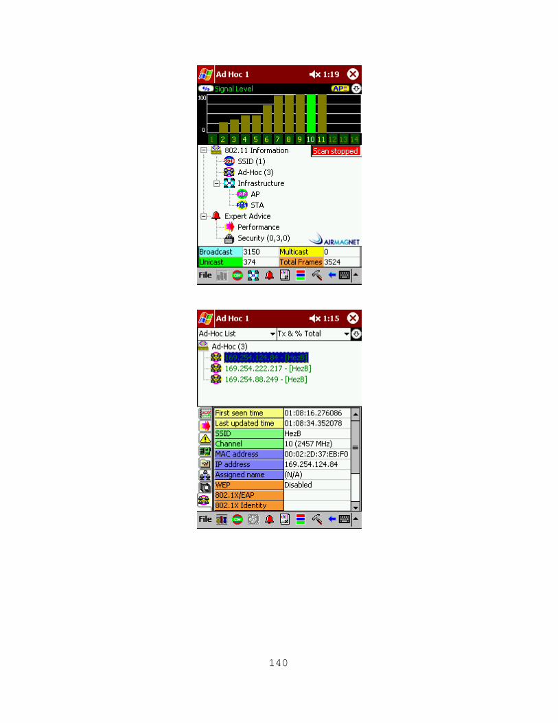
140
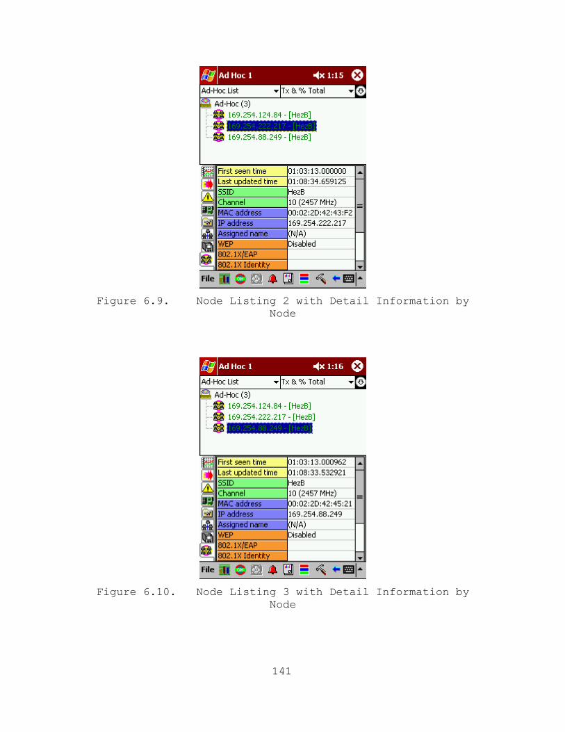
Figure 6.9. Node Listing 2 with Detail Information by
Node
Figure 6.10. Node Listing 3 with Detail Information by
Node
141

Figure 6.11. SSID Listing
Figure 6.12. Channel Listing
142
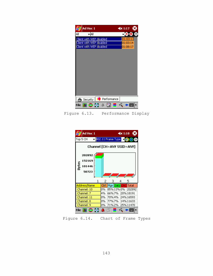
Figure 6.13. Performance Display
Figure 6.14. Chart of Frame Types
143
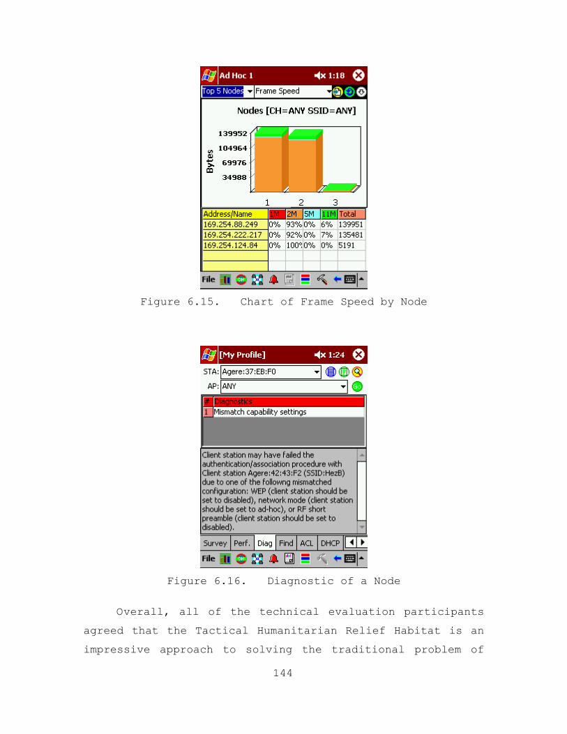
Figure 6.15. Chart of Frame Speed by Node
Figure 6.16. Diagnostic of a Node
Overall, all of the technical evaluation participants
agreed that the Tactical Humanitarian Relief Habitat is an
impressive approach to solving the traditional problem of
144
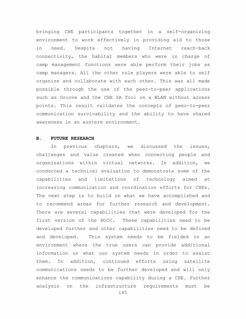
bringing CHE participants together in a self-organizing
environment to work effectively in providing aid to those
in need. Despite not having Internet reach-back
connectivity, the habitat members who were in charge of
camp management functions were able perform their jobs as
camp managers. All the other role players were able to self
organize and collaborate with each other. This was all made
possible through the use of the peer-to-peer applications
such as Groove and the CHE SA Tool on a WLAN without access
points. This result validates the concepts of peer-to-peer
communication survivability and the ability to have shared
awareness in an austere environment.
B. FUTURE RESEARCH
145
In previous chapters, we discussed the issues,
challenges and value created when connecting people and
organizations within virtual networks. In addition, we
conducted a technical evaluation to demonstrate some of the
capabilities and limitations of technology aimed at
increasing communication and coordination efforts for CHEs.
The next step is to build on what we have accomplished and
to recommend areas for further research and development.
There are several capabilities that were developed for the
first version of the ROCC. These capabilities need to be
developed further and other capabilities need to be defined
and developed. This system needs to be fielded in an
environment where the true users can provide additional
information on what our system needs in order to assist
them. In addition, continued efforts using satellite
communications needs to be further developed and will only
enhance the communications capability during a CHE. Further
analysis on the infrastructure requirements must be
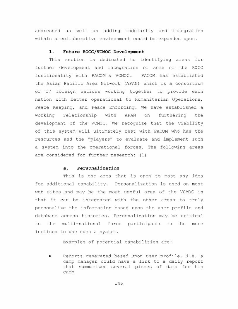
addressed as well as adding modularity and integration
within a collaborative environment could be expanded upon.
1. Future ROCC/VCMOC Development
This section is dedicated to identifying areas for
further development and integration of some of the ROCC
functionality with PACOM’s VCMOC. PACOM has established
the Asian Pacific Area Network (APAN) which is a consortium
of 17 foreign nations working together to provide each
nation with better operational to Humanitarian Operations,
Peace Keeping, and Peace Enforcing. We have established a
working relationship with APAN on furthering the
development of the VCMOC. We recognize that the viability
of this system will ultimately rest with PACOM who has the
resources and the “players” to evaluate and implement such
a system into the operational forces. The following areas
are considered for further research: (1)
a. Personalization
This is one area that is open to most any idea
for additional capability. Personalization is used on most
web sites and may be the most useful area of the VCMOC in
that it can be integrated with the other areas to truly
personalize the information based upon the user profile and
database access histories. Personalization may be critical
to the multi-national force participants to be more
inclined to use such a system.
Examples of potential capabilities are:
• Reports generated based upon user profile, i.e. a
camp manager could have a link to a daily report that summarizes several pieces of data for his camp
146
• Users could be alerted when someone that they frequently communicate with changes locations or contact information
• Alerts provided when requirements arise within a specific user or organizations capability
b. Operations
This may be the most important part of the VCMOC
in that the information contained here is the important
day-to-day information that is used by every potential user
in the operation area. Some ideas for development:
• Better integration of digital maps into the web site.
• Method of storing and accessing historical information and reports on the situation
• Continued improvement on the ability to provide real-time updates to the user either via alerts on the web page or via email updates
c. Organizations
This section is the most basic in content and
information. However, it is still in need of additional
functionality.
• Provide the user with the ability to search organizations by capability.
• Provide links to the organizations parent site via the registration process (i.e. when an organization is registered, the link is inserted in the database for display on the details page).
d. Displaced Persons
This section is ripe for additional
functionality. The basic problem of entering data into the
database could be made easier by automating entry of the
photo into the database. Additional improvements are:
147
• Automatic report reconciling missing family
members
• Notification reports to camp managers of displaced persons being relocated to their camp
• Additional queries to the database based on demographic information
• Reports generated on displaced persons who are missing family members
• Automated method of integrating photos into the displaced persons database
e. Points of Contact
This module is very similar to the organization
module in that the information is basic and easily
manipulated. However, the following improvements should be
considered.
• Automated method of integrating photos into the
point of contact database
• GPS tracking of point of contact location integrated into the database
• Ability to contact POC based on location, including GPS, integrated into a collaborative envelope tool such as Groove
f. Camp Management
148
This is a very important part of the VCMOC in
that each campsite, whether it is for an organizations
headquarters or a relief area, needs to be registered with
information available to those who may need it. The basic
information is available in the current version of the
ROCC, however the entire Displaced Persons module within
the ROCC needs to be integrated into the VCMOC as well as
additional pieces of information. Further exploration is
required in the area.
g. Requirements
If the contact information is the most important
aspect of the VCMOC, then this section is a close second.
Currently in Kuwait, the Civil Military Operations Unit are
having to deal with over 15 International Organizations who
showed up in theater with medical supplies for the relief
effort and yet, they are not needed (XX). This is where
there is the most potential for relief operations.
Organizations need the ability to evaluate and analyze
requirements prior to arriving in theater in order to
optimize their resource potential. This module is ripe for
additions in functionality.
• Reports that match providers with requirements
• Automated alerts when capabilities are present to meet specific requirements utilizing multi-agent architecture
• Integrated logistics module that coordinates and monitors delivery of promised goods and services
2. General Development
a. Database Verification
Due to recent events, it has become very apparent
that we need to be very cautious with individuals who may
be trying to infiltrate US or UN refugee/EPW camps and may
be known or suspected terrorists. As individuals are being
processed into camps, data on these individuals will be
collected and input into the database to include a picture,
name, city of origin and many other data elements. Another
aspect for further research is the implementation of
digital fingerprinting and ubiquitous surveillance
integrated within the ROCC/VCMOC to further identify these
149
individuals. Ultimately, further research could be
conducted to provide a link between our database and the
CIA/FBI known terrorist or most wanted database for a
possible match either by name, facial recognition, or by
digital fingerprints. In fact, utilizing intelligent agents
between the two databases to conduct the search and then
prompt/alert proper authorities as well as the CMOC for
possible investigation and/or action.
b. Satellite Communication
Although adhoc peer-to-peer networks work great
in remote locations, satellite connectivity is critical for
real-time situational awareness throughout the theater as
well as having reach back connectivity to essentially
anywhere in the world. As demonstrated throughout Operation
Iraqi Freedom, embedded reporters throughout Iraq were able
to report the events as they unfolded in real-time via
mobile satellite ground stations mounted on tactical
vehicles. The satellite terminal used throughout the war
was the TT3082A. (37) It is a vehicular Global Area Network
satellite terminal designed for voice fax, data and video
communications from stationary and moving vehicles. It
supports the two key operating modes of the Inmarsat Global
Area Network including Mobile ISDN and Mobile Packet Data
(MPDS). Mobile ISDN supports voice, fax, large data files
and video transmission while Mobile Packet Data is ideal
for email, Internet and other burst transmission
applications from the vehicle. Its features include:
150
• Provides Mobile ISDN and Mobile Packet Data Transmission to remote sites.
• Provides voice, fax and 33.6 or 64 kbps data communications including digital video in Mobile ISDN mode.
• Use of dual terminals permits videoconferences and data transmission at 128 kbps.
• New MPDS mode allows continuous connection for packet transmission only - ideal for email and Internet.
Satellite ground stations such as the TT3082A has
proven itself in a time of war and is worth pursuing to
provide the robust real-time reach back connectivity that
is ultimately desired.
c. Modularity
Decision Support Systems (DSS) are interactive,
computer-based tools that help decision makers use
information and models to solve unstructured problems. (1)
Often the term modularity or design by modules is used when
describing decision support systems. Modularity during
design allows for incremental development and
modifications, which can be done on isolated components
without affecting the whole system. When a system is built
with functional modules or components it is constructed
with standardized units based on functional categories
providing for flexibility and variety in use depending on
the scale and scope of the implementation.
The VCMOC should contain enough modularity to
accommodate the myriad scenarios to which it will be
applied during relief operations. A "core" suite of the
VCMOC should be built to include the basic functionality
151
for any relief operation including a standard database and
hardware configuration. This core capability will be rated
to accommodate a set number of relief workers and process a
set number of individuals receiving aid. As the number of
people involved increases, the appropriate number of core
component assets will be added.
In addition to the core components, the VCMOC
should contain specific functional modules that can be
added to the core system based on specific scenarios. The
following are some examples of the types of modules that
could be added:
• Geographic location - hot weather, cold weather,
desert, jungle.
• Size of effort.
• Composition of organizations involved - Military, Civilian, NGO, IO, Independent.
• Modules based on the languages involved.
• Hostile and non-hostile environment.
• Multiple databases.
• Network architecture - mature well-established or expeditionary wireless.
• Application integration - does the scenario provide for the ROCC to tie into a larger system or is it stand-alone.
Modularity allows for the appropriate response to
be tailored to the specifics of the requirement. This
allows for a level of efficiency and allocation of assets,
that directly targets the scale and scope of the operation.
152
C. THESIS CONCLUSION
The next big challenge for this thesis will not be
technological, but the beta testing of this project in a
real world CHE. We have devoted a significant amount of
time working with the staff of the USPACOM APAN on the
integration of the camp management, displaced persons, and
situational awareness tool into the VCMOC. APAN is
scheduled to conduct a technical evaluation similar to the
one conduct at MCBH, but at the joint task force level
during Cobra Gold 2003 in Thailand. During this event,
military civil affairs personnel, NGOs, and IOs will survey
the components of the Tactical Humanitarian Relief Habitat
and provided valuable feedback.
This completes the second phase of the project as
described in Chapter I. APAN will initiate Phase 3 in May
in partnership with Dr. Bordetsky and Eugene Bourakov. They
will continue to use existing COTS technology to establish
satellite Internet connectivity and to setup an ad hoc
wireless network in the field/tactical environment that
will enable the beta testing of the VCMOC. Additionally,
more software agents will be incorporated into the
prototype to enhance the situational awareness and decision
support functionality.
153

THIS PAGE INTENTIONALLY LEFT BLANK
154
APPENDIX A. SATELLITE ACQUISITION INSTRUCTIONS STANDARD OPERATING PROCEDURES
Purpose. These instructions are intended to provide
necessary information required for the proper installation
of the NASA Advanced Communication Technology Satellite
(ACTS) antenna assembly and mobile ground station (MGS).
Assumptions. A basic understanding of satellite
communication systems (NPS Classes SS-3011 and SS-3613).
Instructions. The following is the instructions for
installation of the NASA ACTS system:
• Level the antenna base using the level bubble on
the base.
• Put dish at the appropriate elevation for location (e.g. 18 degrees from vertical for NPS, 04 degrees for Hawaii).
• Point the dish in the azimuth for the given location (e.g. aim at approximately 140 degrees for NPS, 103 degrees for Hawaii). It is advisable to place the azimuth actuator in the center of its range in order to allow for maximum flexibility in sweeping and adjusting (e.g. the numerical output on the antenna controller has a range for the angle that extends from 30 to 1000 units. Adjust the controller until it is at about 500 units and then physically move the antenna base to point to the intended azimuth).
• Power up dual access antenna controller.
• Verify the transmit and receive frequencies and the corresponding data rates. This is accomplished by checking the modem configuration settings and confirming those settings match the Cleveland Operations center settings.
• Attempt to use the ‘Auto’ mode to acquire the satellite. On the antenna controller, push the mode button until you see ‘Auto’ on the digital
155
display and push ‘Enter.’ (This usually does not work to acquire the satellite).
• Turn master attenuator knob clockwise to increase attenuation counterclockwise to decrease attenuation. Begin acquisition with both attenuation knobs turned all the way down (counterclockwise).
• On the SM3000, if the status/fault light is red, you don’t have a signal
• If no signal is received (indicated by the signal strength meter on the antenna controller) after attempting to auto track, switch to ‘Manual’ mode. This is done the same way as selecting Auto mode. Press the ‘Mode’ button until ‘Manual’ appears and then press ‘Enter.’
• If a signal is detected, allow auto mode to peak the signal. If the signal strength gets too high (the range is 0-999, if the signal is too strong a *** will appear), increase attenuation until minimal signal is received and continue to track until the ‘CARR LOCK’ light is green.
• In ‘Manual’ mode, the same concept is used to find the strongest signal strength.
• Use up/down buttons in order to get signal strength. Sweep horizontally until the strongest peak is identified and then sweep vertical until that peak is identified. Continue process until the ‘CARR LOCK’ light is green. (Note: Sometimes signal strength can be peaked without getting carrier lock. This is probably because the antenna is tracking on a lobe of the signal and not the main signal. Continue sweeping to search for main lobe).
• This is an iterative process and takes time and patience.
• Once a signal is acquired and Carrier lock is achieved, optimize signal strength by going to auto mode.
156
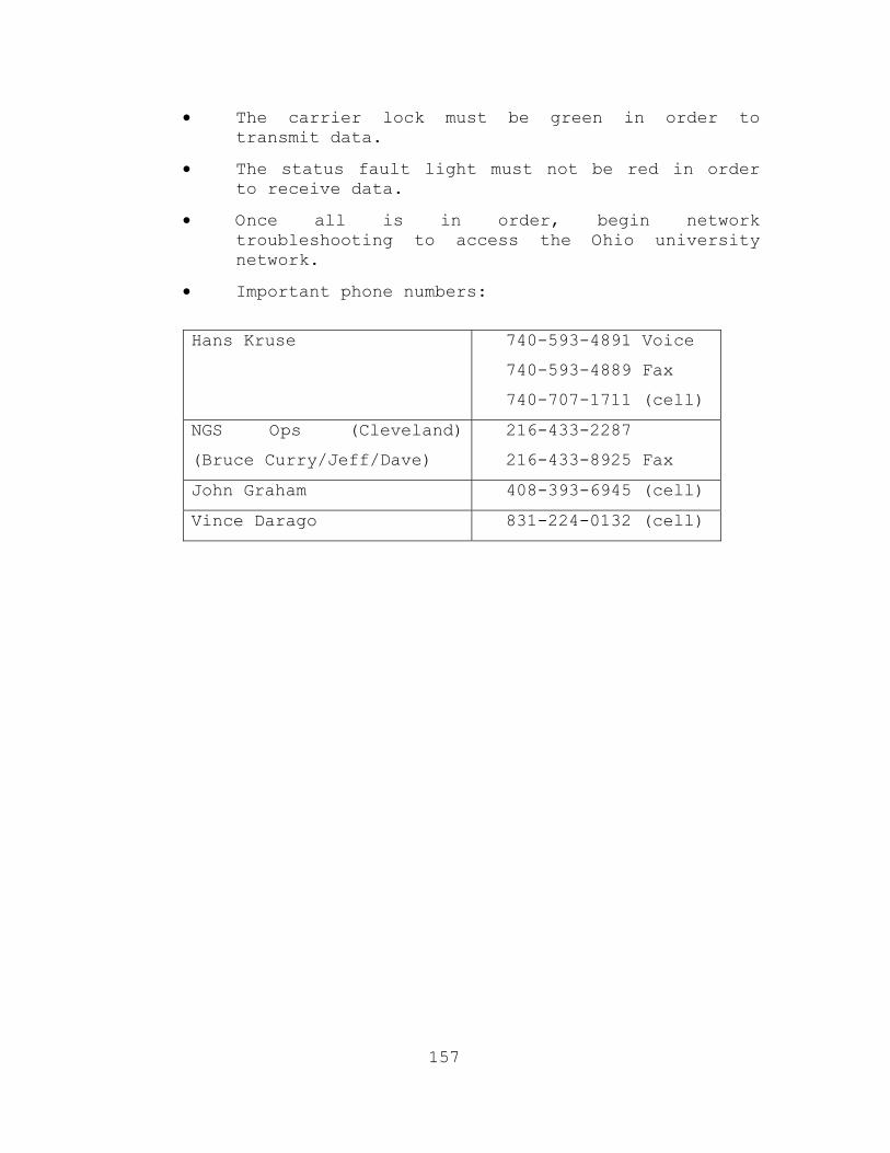
• The carrier lock must be green in order to transmit data.
• The status fault light must not be red in order to receive data.
• Once all is in order, begin network troubleshooting to access the Ohio university network.
• Important phone numbers:
Hans Kruse 740-593-4891 Voice
740-593-4889 Fax
740-707-1711 (cell)
NGS Ops (Cleveland)
(Bruce Curry/Jeff/Dave)
216-433-2287
216-433-8925 Fax
John Graham 408-393-6945 (cell)
Vince Darago 831-224-0132 (cell)
157
THIS PAGE INTENTIONALLY LEFT BLANK
158
APPENDIX B. TECHNICAL EVALUATION SCENARIO 1
Purpose. This scenario is designed to demonstrate the
ability of a CHE participant to effectively conduct
humanitarian relief efforts with the Tactical Humanitarian
Relief Habitat.
Assumptions.
• Each participant has access to the Tactical
Humanitarian Relief Habitat.
• Each participant has Groove collaborative software.
• Each participant has the ‘Object Tracer’ software in order to utilize the GPS functionality of the CHESA tool.
Evaluation Objectives.
• Register as a new member.
• View CHE information (e.g. needs, other participants, meetings, POCs).
• Post CHE resource information (e.g. available resources for support).
• Sign up for meetings.
• Conduct Groove session.
• Share files.
• VoIP conversation.
• Chat.
• Text messaging.
• Voice messaging.
• Conduct Power Point presentation.
• Utilize CHESAT.
• Post alert.
159
• Use GPS Poster
• Send and receive text messages within the CHESAT.
• Search displaced persons.
160
APPENDIX C. TECHNICAL EVALUATION SCENARIO 2
Purpose. This scenario is designed to demonstrate the
ability of the Tactical Humanitarian Relief Habitat manager
to effectively administer the network.
Assumptions.
The network administrator has SolarWinds and AirMagnet
network management software.
802.11b wireless technology will be utilized within
the network.
Evaluation Objectives.
Identify what nodes are accessing the network through
the wireless access point.
Monitor network latency, packet loss, traffic and
bandwidth usage.
Obtain IP addresses of nodes on the wireless network
utilizing the CISCO discovery protocol.
Conduct an Access Point installation survey.
Identify unauthorized Access Points.
161
THIS PAGE INTENTIONALLY LEFT BLANK
162
LIST OF REFERENCES
1. Ford, Hogan Perry, Thesis Titled “Communication During Complex Humanitarian Emergencies: Using Technology to Bridge the Gap,” September 2002.
2. “Taking it to the Next Level: Civilian-Military Cooperation in Complex Emergencies,” Conference Report, August 2000, United States Institute of Peace, Washington D.C.
3. [www.Reliefweb.int], November 26, 2002, February 2003.
4. Multiservice Procedures for Humanitarian Assistance Operations, Air Land and Sea Application Center.
5. UN: Fribourg Forum on Crisis Management to Discuss Thorny Issues, Duplication of Mandates and Obstacles to Rapid Delivery of Humanitarian Assistance, June 7, 2000, M2 Presswire, Coventry.
6. [www.AIMS.org.pk], October 18, 2002.
7. JP 3-08, Interagency Coordination During Joint Operations, 2 Volumes, October 9, 1996.
8. JP 3-07 Joint Doctrine for Military Operations Other Than War, June 16, 1995.
9. Virtual Diplomacy Series, Taking It to the Next Level, Civilian-Military Cooperation in Complex Emergencies, Appendix 1, The Realities of Coordination/Cooperation: Debunking as a Survival Tool, H. Roy Williams, Director of the Office of Foreign Disaster Assistance, Bureau for Humanitarian Response, USAID.
10. Seiple, Chris, The US Military/NGO Relationship in Humanitarian Intervention, Peace Keeping Institute, Center for Strategic Learning, U.S. Army War College, 1996.
11. Hotstetter, Melinda, Cross Cultural Relations Between Civilian and Military Organizations, Presentation by Melinda Hotstetter, Center for Disaster Management and Humanitarian Assistance, Tulane University, Washington, DC, 2000.
163
12. Interview, Michael W. Perry with Michael D. Schultz, Program Manager C3AITG, February 13, 2002.
13. Joint Publication 3-57 Doctrine for Joint Civil Affairs, June 21, 1995.
14. Wilkins, Aaron L. Major, THE CIVIL MILITARY OPERATIONS CENTER (CMOC) IN OPERATION UPHOLD DEMOCRACY (HAITI) A Research Paper, Air Command and Staff College, March 1997.
15. III Marine Expeditionary Force, Draft CMOC Standard Operationing Procedures, December 1994.
16. JP 3-08, Interagency Coordination During Joint Operations, 2 Volumes, October 9, 1996.
17. [http://www.mod.uk/jdcc/cimic.htm], March 10, 2003.
18. [http://www.reliefweb.int/undac/documents/insarag/guidelines/DutiOSO.html], March 14, 2003.
19. [http://www.reliefweb.int/hcic], March 14, 2003.
20. McDaniel, John R. Evidence Based Research, Personal Correspondence – Email, May 22, 2002.
21. Davidson, L., Hayes, M. and Landon, J., Humanitarian and Peace Operations: NGOs and the Military in the Interagency Process, National Defense University Press Book, 1996, [http://www.ndu.edu/inss/books/ngopvo], March 2003.
22. World Disaster Report, International Federation of Red Cross and Red Crescent Societies, 1997.
23. Joint Publication 3-07.5, Joint Tactics, Techniques and Procedures for Noncombatant Evacuation Operations.
24. MacIntyre, Douglas J., Current Technology and NEO: Bringing a MEU(SOC) Mission Into the Digital Age, 2001.
25. Jaques, Lynda, Complex Humanitarian Emergency/Peace Operations Planning Tool, DMSO, STID Proposal White Paper, U.S. Pacific Command, Research and Analysis Division, J08, 2000.
164
26. Sovereign, Michael G., Humanitarian Assistance and Disaster Relief in the Next Century, National Defense University, 1997.
27. [http://coe-dmha.org/Liaison/Vol_2No_1/Feat02.htm], February 3, 2003.
28. Document, Using the Conceptual Model of Peace Operations (CMPO), The Program on Peacekeeping Policy, The Institute of Public Policy, George Mason University.
29. Jaques, Lynda, Peace Operations Support Tool (POST), Presentation Given by Dr. Lynda Jaques, U.S. Pacific Command, Research and Analysis Division, J08, 2002
30. [http://www.reliefweb.int/hcic], March 18, 2003.
[http://www.reliefweb.int/help/whatwedo.html], March 18, 2003.
[http://www.reliefweb.int/help/mandate.html], March 18, 2003.
31. Berry, Sharon, “Collaborative Tool Buddy-Lists Coalition Partners,” SIGNAL, May 2002.
32. [http://www.reliefweb.int/undac/documents/iercm/Report_IERCM_CoreGroup_June00_Geneva.doc], March 3, 2003.
33. “Taking It to the Next Level: Civilian-Military Cooperation in Complex Emergencies,” Conference Report, August 2000, United States Institute of Peace, Washington D.C.
34. [http://www.reliefweb.int/symposium/bp_resources.htm], March 21, 2003.
35. [http://www.cs.man.ac.uk/ipg/CS637/quicktour.pdf], December 22, 2002.
36. Bratton, John M., (US Pacific Command), Memorandum for Record, September 26, 2002.
37. [http://www.comsatsys.com/Pages/satellite_phones/tt3082a.htm], April 30, 2003.
165

THIS PAGE INTENTIONALLY LEFT BLANK
166
INITIAL DISTRIBUTION LIST
1. Defense Technical Information Center Ft. Belvoir, Virginia
2. Dudley Knox Library
Naval Postgraduate School Monterey, California
3. Marine Corps Representative
Naval Postgraduate School Monterey, California
4. Director, Training and Education MCCDC, Code C46
Quantico, Virginia 5. Director, Marine Corps Research Center MCCDC, Code C40RC
Quantico, Virginia 6. Professor Dan C. Boger, Code IS
Naval Postgraduate School Monterey, California [email protected]
7. Professor Alex Bordetsky, Code IS Naval Postgraduate School Monterey, California
8. LCDR Glenn Cook, Code IS
Naval Postgraduate School Monterey, California
167


