Embed Size (px)
Citation preview
Latrobe Valley Regional Rehabilitation Strategy – Program Summary01 Introduction............................................................................................................................................................... 2
Background.................................................................................................................................................................. 2Scope and Implementation............................................................................................................................................ 2Spatial scale................................................................................................................................................................. 5Temporal scale............................................................................................................................................................. 7Coordination with other studies...................................................................................................................................... 7Closure of Hazelwood Coal Mine................................................................................................................................... 7
02 Study program........................................................................................................................................................... 7General approach......................................................................................................................................................... 7Receptor analysis......................................................................................................................................................... 8
Geotechnical metrics, thresholds and current status...................................................................................................9
Water and environmental metrics, thresholds and current status.................................................................................9
Geotechnical studies..................................................................................................................................................... 9Collate and compile existing geotechnical data and methods......................................................................................9
Geotechnical effects preliminary assessment.............................................................................................................9
Geotechnical effects quantitative assessment...........................................................................................................10
Regional geotechnical monitoring plan..................................................................................................................... 10
Water and environmental studies................................................................................................................................. 10BASELINE.............................................................................................................................................................. 11
SCOPING............................................................................................................................................................... 12
INVESTIGATION.................................................................................................................................................... 12
MODEL DEVELOPMENT........................................................................................................................................ 13
MODELLING........................................................................................................................................................... 13
ASSESSMENT....................................................................................................................................................... 13
Land use Planning studies........................................................................................................................................... 13STAGE 2................................................................................................................................................................. 14
STAGE 3................................................................................................................................................................. 14
STAGE 4................................................................................................................................................................. 14
Cumulative impact assessment................................................................................................................................... 15Source–Pathway–Receptor Model........................................................................................................................... 15
Regional Rehabilitation Scenarios (Source)..............................................................................................................16
Recognised Regional Receptors (Receptors)...........................................................................................................16
Pathways................................................................................................................................................................ 16
Exogenous Effects................................................................................................................................................... 16
Quantitative vs Qualitative Impacts........................................................................................................................... 16
1
Latrobe Valley Regional Rehabilitation StrategyProgram Summary
Biophysical feasibility assessment............................................................................................................................... 16
03 Stakeholder and community engagement..............................................................................................................17Engagement strategy.................................................................................................................................................. 17Latrobe Valley Mine Rehabilitation Advisory Committee...............................................................................................19Latrobe Valley Mine Rehabilitation Commissioner........................................................................................................20
04 Outcome for the community.................................................................................................................................... 21
01 IntroductionThe Latrobe Valley Regional Rehabilitation Strategy (LVRRS) is part of the Victorian Government’s response to the findings of the Hazelwood Mine Fire Inquiry (HMFI), which found that there were significant uncertainties and gaps in knowledge surrounding the closure and rehabilitation of the Latrobe Valley’s three brown coal mines. Specifically, the HMFI’s Board of Inquiry found that, with the current knowledge available, some form of pit lake was the most viable rehabilitation option for the coal mine voids, but that there remain many unanswered questions concerning the feasibility of pit lakes.1
The LVRRS will address some of these knowledge gaps through a series of technical studies over the coming years, with a final LVRRS report to be completed by June 2020. This document provides a summary of the approach and method to be applied in preparing the LVRRS.
BackgroundIn 2014, a fire occurred at the Hazelwood Coal Mine that burnt for 45 days. The fire had a significant impact on the nearby community of Morwell and raised serious questions about health effects, the emergency response and the long-term safety of the Latrobe Valley’s three brown coal mines.
The Victorian Government implemented a two-part independent inquiry to thoroughly investigate the cause and effects of the mine fire, to consider improvements to the health of the Latrobe Valley community, and to examine the options for rehabilitation of the coal mines once they close.
In response to the HMFI findings, the Victorian Government released a detailed Implementation Plan2 that included a commitment to develop a Regional Rehabilitation Strategy for the Latrobe Valley’s three coal mines (the LVRRS). In accordance with the Implementation Plan, the strategy will be developed in consultation with mine owners, relevant water corporations, key stakeholders and the community. The final LVRRS is to be delivered by June 2020.
The LVRRS3 is intended to address key knowledge gaps relating to mine rehabilitation as identified by the Inquiry. The Victorian Government is responsible for delivering the LVRRS, led by the Department of Economic Development, Jobs, Transport and Resources (DEDJTR) in partnership with the Department of Environment, Land, Water and Planning (DELWP). The delivery of actions defined in the Implementation Plan related to the LVRRS is independently monitored by the Inspector-General for Emergency Management.
Scope and ImplementationThe Hazelwood Mine Fire Inquiry: Victorian Government Implementation Plan June (2016) outlines the actions to be undertaken to prepare the LVRRS.
The Implementation Plan sets out that DEDJTR and DELWP, in collaboration with the operators of the Latrobe Valley coal mines and the community, and with input from technical experts, are to undertake the following actions:
investigations to address knowledge gaps relating to mine rehabilitation, such as geotechnical stability, hydrogeological risks and water availability
working with the community and the operators of the Latrobe Valley coal mines to understand the findings of these investigations
1 hazelwoodinquiry.vic.gov.au/201516-report/volume-iv-mine-rehabilitation/index.html
2 earthresources.vic.gov.au/earth-resources/hazelwood/hazelwood-mine-fire-inquiry-implementation-plan
3 earthresources.vic.gov.au/earth-resources/hazelwood/hazelwood-mine-fire-inquiry-implementation-plan/the-latrobe-valley-regional-rehabilitation-strategy
2
Latrobe Valley Regional Rehabilitation StrategyProgram Summary
developing a Latrobe Valley Regional Rehabilitation Strategy to guide regional level planning for mining operations, rehabilitation, mine closure and post closure, taking account of the interconnectivity between the three mine voids.
Specifically, the LVRRS will investigate the feasibility of full pit lake and partial pit lake rehabilitation options for the Latrobe Valley coal mines, which were found by the Inquiry to be “currently the most viable rehabilitation option, although considerable further investigation is required, as new knowledge could result in an alternative preferred option4”.
The Implementation Plan further specified that these investigations will include:
regional geotechnical and hydrogeology studies to address knowledge gaps
regional water studies, in areas such as groundwater and surface water balance, water quality (in the pit lakes and potential impacts on downstream users), and potential impacts on: aquatic ecosystems; downstream water users; long-term water availability (including climate change scenarios); and the environment
an assessment of potential regional impacts to the environment including to ecology, adjacent Crown land and sensitive land uses and values. This will include an assessment of the acceptability of any residual impacts on surrounding environmental values
an assessment of regional impacts of closure of the Latrobe Valley coal mines, taking into account a range of potential mining operational and closure scenarios and the interconnections with other land uses and major infrastructure in the Latrobe Valley
a post-closure monitoring and evaluation plan
consideration of the Latrobe Valley coal mines and power station water entitlements and licences that may be required to implement the Strategy
a review of State and local planning policies to take into account strategic land use planning, major infrastructure planning and environmental implications of closure and rehabilitation of the Latrobe Valley coal mines
identification of any legislative or regulatory reforms required to implement the Strategy.
Figure 1: Implementation Plan action framework
Regulatory/Geotechnical
Governance Water/Environmental
Stage 1 185. Review current mine rehabilitation strategies (DEDJTR)
Dec 2016
Stage 2 187. Review existing water entitlements and licensing (DELWP)
186. Establish Latrobe Valley Mine Rehabilitation Commissioner (DEDJTR)
190. Annual progress review (DEDJTR)
188. Baseline report on existing water use, availability, aquatic ecosystems and water quality (DELWP)
189. Brief the Commissioner (DEDJTR)
192. Review Stage 2 outputs and confirm Stage 3 plan (DEDJTR)
191. Assess impacts of climate change on water availability (DELWP)
Dec 2017
Stage 3 194. Deliver Regional Geotechnical Study (DEDJTR)
195. Deliver Regional Water Study (DELWP)
196. Review Stage 3 outputs 4 Hazelwood Mine Fire Inquiry Report 2015/2016 Volume 4, p. 114
3
Latrobe Valley Regional Rehabilitation StrategyProgram Summary
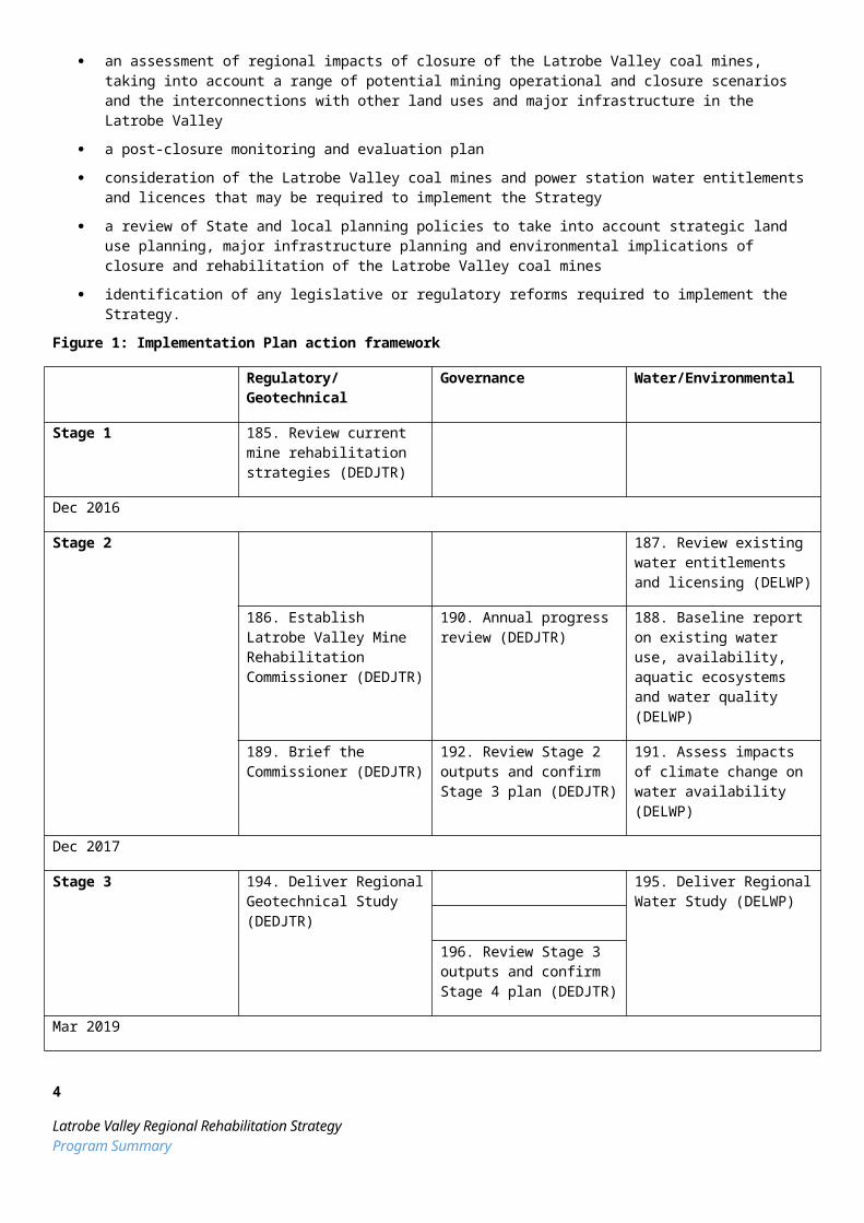
Regulatory/Geotechnical
Governance Water/Environmental
and confirm Stage 4 plan (DEDJTR)
Mar 2019
Stage 4 198. Review policy/legislation needed to implement LVRRS (DEDJTR)
197. Annual progress review (DEDJTR)
199. Review water entitlements and licensing needed to implement LVRRS (DELWP)
201. Draft integrated LVRRS (DEDJTR)
200. Draft regional impact assessment (DEDJTR / DELWP)
203. Final LVRRS (DEDJTR)
202. Final regional impact assessment (DEDJTR / DELWP)
Mar 2020
As part of project initiation (Stage 1), a detailed Project Plan to guide preparation of the LVRRS was developed in consultation with a number of key stakeholders and independent, external experts. The Project Plan covers investigations contributing to Stages 2, 3 and 4 of the LVRRS Implementation Plan.
The methodology for these investigations draws on expert advice and includes modelling and assessment of several pit lake-based rehabilitation scenarios, building on existing data and current field programs.
In summary, the objective of the LVRRS technical investigation program is to determine if the pit lakes option can deliver a safe, stable and sustainable rehabilitation solution for the Latrobe Valley in the context of limited water availability, a sensitive downstream environment, climate change, aboriginal and non-aboriginal heritage values, and strong community interest in achieving a final landform that can support beneficial land uses.
The Implementation Plan divides the delivery of the LVRRS into five stages:
Stage 1: Project initiation (planning, stakeholder engagement, project team and governance establishment)
Stage 2: Existing conditions review (data availability, baseline conditions, knowledge gaps)
Stage 3: Modelling and analysis (prediction of effects, assessment of impacts)
Stage 4: Integration of findings (cumulative impact and feasibility assessment)
Stage 5: Ongoing review and adaptation (‘living’ document phase)
The HMFI actions in each stage and schedule for delivery are shown in Figure 1. Note that the LVRRS also encompasses a Land Use Planning Study (see Figure 4) that is not linked directly with the HMFI action framework.
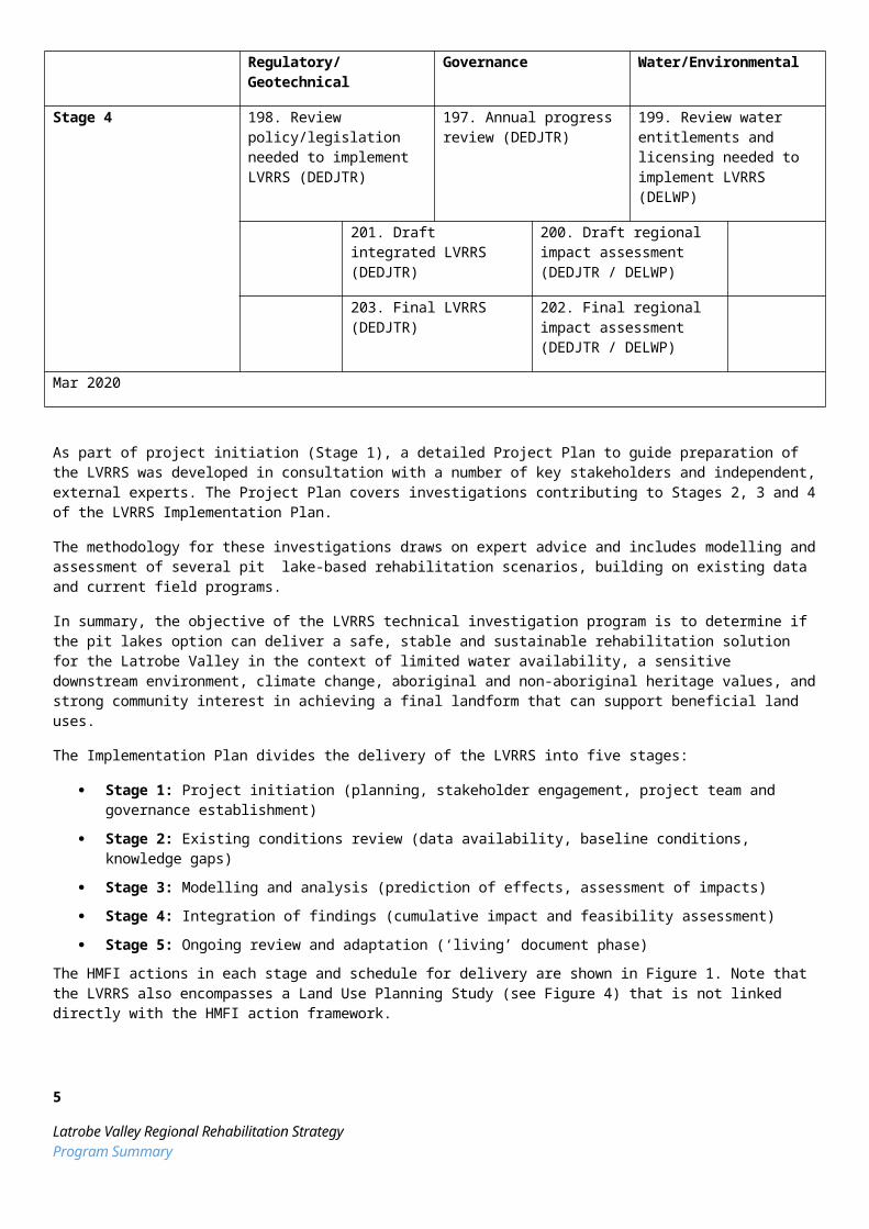
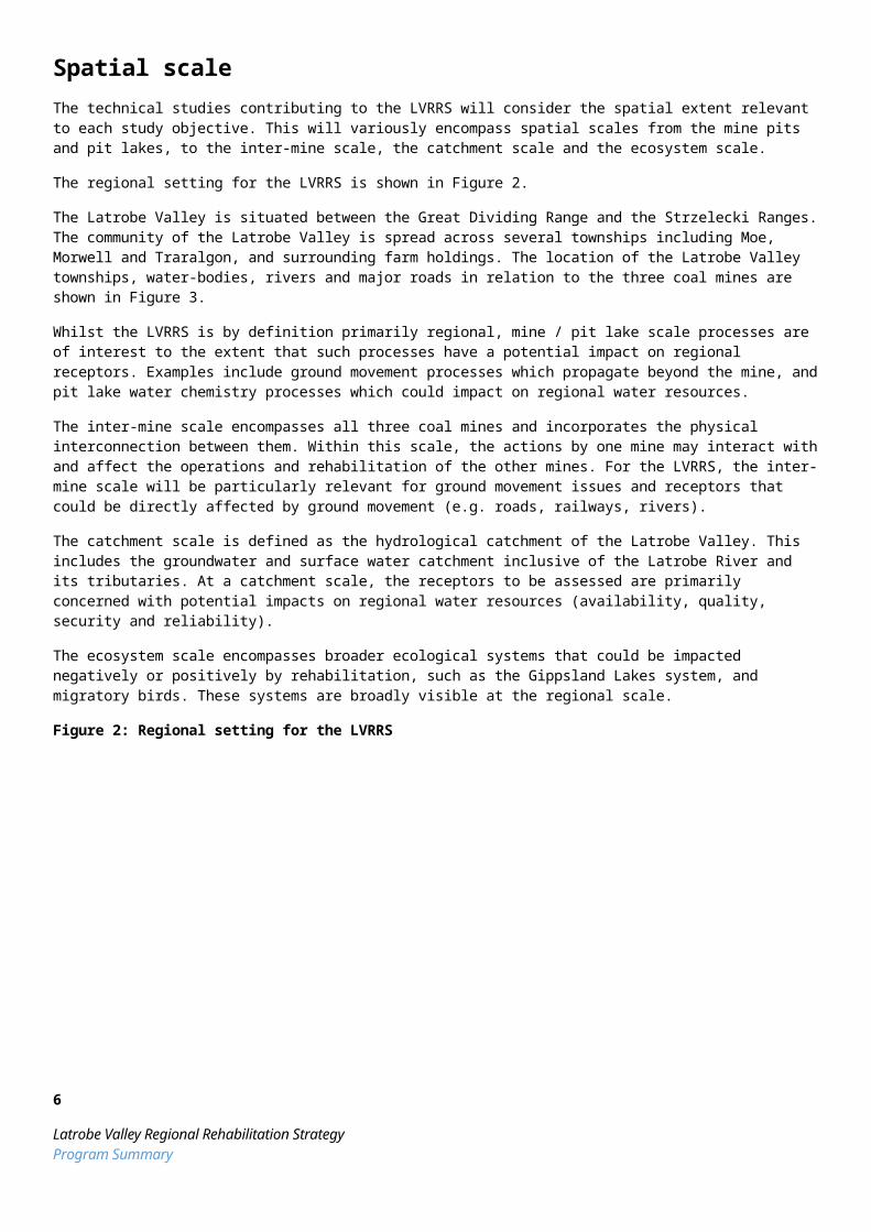
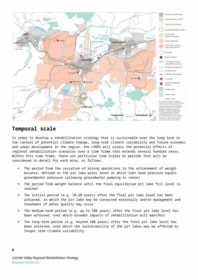
Spatial scaleThe technical studies contributing to the LVRRS will consider the spatial extent relevant to each study objective. This will variously encompass spatial scales from the mine pits and pit lakes, to the inter-mine scale, the catchment scale and the ecosystem scale.
The regional setting for the LVRRS is shown in Figure 2.
The Latrobe Valley is situated between the Great Dividing Range and the Strzelecki Ranges. The community of the Latrobe Valley is spread across several townships including Moe, Morwell and Traralgon, and surrounding farm holdings. The location of the Latrobe Valley townships, water-bodies, rivers and major roads in relation to the three coal mines are shown in Figure 3.
4
Latrobe Valley Regional Rehabilitation StrategyProgram Summary
Whilst the LVRRS is by definition primarily regional, mine / pit lake scale processes are of interest to the extent that such processes have a potential impact on regional receptors. Examples include ground movement processes which propagate beyond the mine, and pit lake water chemistry processes which could impact on regional water resources.
The inter-mine scale encompasses all three coal mines and incorporates the physical interconnection between them. Within this scale, the actions by one mine may interact with and affect the operations and rehabilitation of the other mines. For the LVRRS, the inter-mine scale will be particularly relevant for ground movement issues and receptors that could be directly affected by ground movement (e.g. roads, railways, rivers).
The catchment scale is defined as the hydrological catchment of the Latrobe Valley. This includes the groundwater and surface water catchment inclusive of the Latrobe River and its tributaries. At a catchment scale, the receptors to be assessed are primarily concerned with potential impacts on regional water resources (availability, quality, security and reliability).
The ecosystem scale encompasses broader ecological systems that could be impacted negatively or positively by rehabilitation, such as the Gippsland Lakes system, and migratory birds. These systems are broadly visible at the regional scale.
Figure 2: Regional setting for the LVRRS
Figure 3: Latrobe Valley coal mine district
5
Latrobe Valley Regional Rehabilitation StrategyProgram Summary
Temporal scale In order to develop a rehabilitation strategy that is sustainable over the long term in the context of potential climate change, long-term climate variability and future economic and urban development in the region, the LVRRS will assess the potential effects of regional rehabilitation scenarios over a time frame that extends several hundred years. Within this time frame, there are particular time scales or periods that will be considered in detail for each mine, as follows:
The period from the cessation of mining operations to the achievement of weight balance, defined as the pit lake water level at which lake head pressure equals groundwater pressure (allowing groundwater pumping to cease)
The period from weight balance until the final equilibrium pit lake fill level is reached
The initial period (e.g. 10-20 years) after the final pit lake level has been achieved, in which the pit lake may be connected externally and/or management and treatment of water quality may occur
The medium-term period (e.g. up to 100 years) after the final pit lake level has been achieved, over which broader impacts of rehabilitation will manifest
The long-term period (e.g. beyond 100 years) after the final pit lake level has been achieved, over which the sustainability of the pit lakes may be affected by longer term climate variability.
Coordination with other studiesThe LVRRS will be adapted in response to progressive findings, information and knowledge produced by the mine operators through their collective 10 Year Integrated Mine Research Program (IMRP), and the Batter Stability Project being conducted at the Yallourn Coal Mine.
The LVRRS project and the IMRP will share information on the potential impacts of pit lake landforms, while seeking to enable data, models and findings to be comparable and add to the collective understanding of the potential regional impacts of pit-lake landforms. The preparation of the LVRRS will draw on the significant body of research and technical work that has already been undertaken, as well as work commissioned as part of this project, to inform robust decision making on the feasibility of the pit lake landform.
6
Latrobe Valley Regional Rehabilitation StrategyProgram Summary
Closure of Hazelwood Coal MineThe Hazelwood Power Station and Coal Mine ceased operation on 31 March 2017, and is expected to submit a revised workplan covering the rehabilitation of the mine and power station site within 3-5 years of this date. The LVRRS will be prepared by June 2020 and will support a regional, integrated approach to mine rehabilitation planning across all three Latrobe Valley mines. In the period to June 2020, and where possible, the LVRRS will provide interim outputs to support planning for rehabilitation of the Hazelwood Coal Mine.
02 Study program General approachThe overall objective of the LVRRS is to complete a comparative assessment of the biophysical feasibility of various combinations of pit lake landforms as regional rehabilitation ‘scenarios’ based on the findings of technical studies and an assessment of cumulative impacts.
The final LVRRS report will therefore be a document comparing possible strategies for rehabilitation to inform discussion and decision-making around a preferred approach to rehabilitation. The LVRRS to be delivered in 2020 is therefore not intended to propose a single ‘masterplan’.
The LVRRS considers the mines individually and collectively (cumulatively) in the context of potential impacts (both positive and negative) on the environment, aboriginal and non-aboriginal cultural heritage values, infrastructure and land uses in the Latrobe Valley, with a particular focus on water and land stability issues, noting that the primary objective of rehabilitation is to achieve a safe and stable landform for the closed mine voids.
The biophysical feasibility assessment incorporates an assessment of cumulative impacts, defined as the collective effects of activities and pressures on the environment (e.g. rivers, lakes, flora, fauna), major infrastructure (e.g. roads, residential property) and other land uses (e.g. agricultural), both direct and indirect, including present and reasonably foreseeable future pressures.
The results of the biophysical feasibility assessment then inform an assessment of the potential social and economic impacts and opportunities of land uses resulting from or supported by the rehabilitation scenarios.
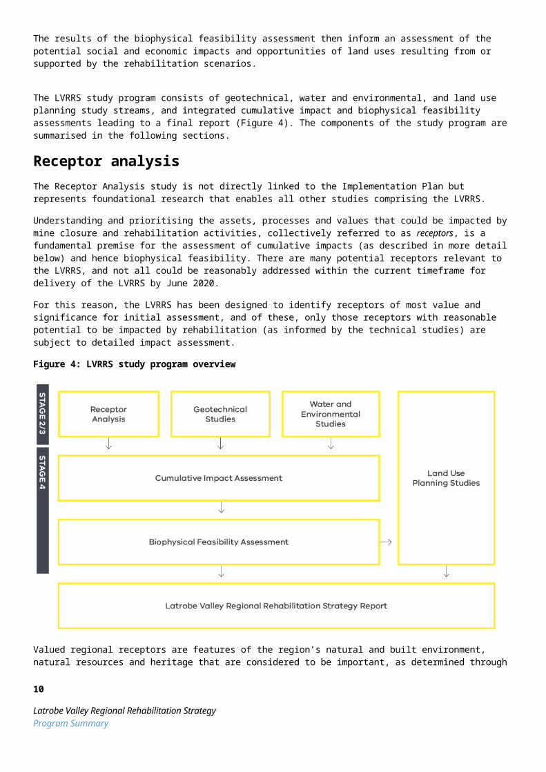
The LVRRS study program consists of geotechnical, water and environmental, and land use planning study streams, and integrated cumulative impact and biophysical feasibility assessments leading to a final report (Figure 4). The components of the study program are summarised in the following sections.
Receptor analysisThe Receptor Analysis study is not directly linked to the Implementation Plan but represents foundational research that enables all other studies comprising the LVRRS.
Understanding and prioritising the assets, processes and values that could be impacted by mine closure and rehabilitation activities, collectively referred to as receptors, is a fundamental premise for the assessment of cumulative impacts (as described in more detail below) and hence biophysical feasibility. There are many potential receptors relevant to the LVRRS, and not all could be reasonably addressed within the current timeframe for delivery of the LVRRS by June 2020.
For this reason, the LVRRS has been designed to identify receptors of most value and significance for initial assessment, and of these, only those receptors with reasonable potential to be impacted by rehabilitation (as informed by the technical studies) are subject to detailed impact assessment.
Figure 4: LVRRS study program overview
7
Latrobe Valley Regional Rehabilitation StrategyProgram Summary
Valued regional receptors are features of the region’s natural and built environment, natural resources and heritage that are considered to be important, as determined through consultation with stakeholders and the community, in assessing the potential cumulative effects of mine rehabilitation.
The objective of the receptor analysis is to define and describe the characteristics of receptors within the LVRRS study area and to identify those receptors considered to be recognised or valued. This will involve:
Nominating criteria for identifying recognised regional receptors
Applying the criteria to develop a comprehensive spatially-enabled data base of recognised regional receptors
Establishing an inventory with baseline information on receptor type, location, ownership and current level of protection.
Metrics and thresholds for quantitative impact assessment will be defined for priority receptors, informed by existing published information and stakeholder consultation. Receptor metrics are the means by which impacts on receptors can be measured (e.g. changes in flow within a particular stretch of a river) and thresholds are the acceptable limits for each metric. Thresholds are developed through the regional geotechnical and water studies.
Geotechnical metrics, thresholds and current statusIn considering potential mine rehabilitation impacts on receptors from ground movement effects related to pit lake landforms, an understanding of each recognised receptor’s tolerability (limits of acceptable change or risk) to ground movement is needed.
There is a variable level of documentation of the ground movement tolerance levels of receptors located in the Latrobe Valley region. For some recognised regional receptors, tolerance levels or the capacity to endure subjection to ground movement, are well defined (e.g. train lines) and in other instances there is no clear definition of tolerability levels (e.g. public open spaces). General tolerability levels may also be defined within guidelines pertaining to the type of receptor.
The objective of this task is to identify the geotechnically related measures or metrics used to quantify ground movement in relation to physical assets, and to determine the current status of those metrics.
Water and environmental metrics, thresholds and current statusThis task aims to define the metrics (measures) and corresponding thresholds to be used to assess the degree of impact or effect of the rehabilitation scenarios on water-related receptors, and the available information on the current status and
8
Latrobe Valley Regional Rehabilitation StrategyProgram Summary
trend of water-related receptors. This foundational work provides a reference for assessing the likely impacts and the degree to which the status of a receptor could change under various rehabilitation scenarios.
Geotechnical studiesThe geotechnical studies correspond to Action 194 (Delivery of a regional geotechnical study) of the Implementation Plan (Figure 1) Stages 2 and 3.
Collate and compile existing geotechnical data and methodsThis study supports the assessment of regional cumulative impacts of mine rehabilitation by compiling disparate geotechnical information held by stakeholders into a single dataset of existing regional knowledge.
The objectives of this task are to collate and compile existing baseline geotechnical data and analysis methods for assessment of cumulative impacts of potential future ground movement within the LVRRS study area. Broadly the task is to:
Outline geological, hydrogeological and geotechnical information used in assessing regional ground movement
Define the principal geomechanical processes relevant to ground movement
Determine whether geotechnical data and analysis methods commonly used are fit for the purpose of preparing the LVRRS.
Geotechnical effects preliminary assessmentThis task draws together outcomes of studies related to regional recognised receptors, geotechnical baseline information and proposed mine pit lake rehabilitation scenarios to provide a preliminary assessment of mine rehabilitation geotechnical effects on recognised receptors.
The objective of this task is to undertake a preliminary assessment of the biophysical feasibility of regional rehabilitation scenarios at each of the LVRRS temporal time scales. This will involve assessing geotechnical processes relevant to regional geotechnical effects on recognised receptors at the inter-mine and regional scale.
Mine rehabilitation effects on recognised receptors requires consideration of a number of factors:
Mining has to date induced land movement at the regional and inter-mine scale
The current extent and magnitude of impact needs to be defined to identify recognised receptors that may have experienced impacts from land movement to date
Mine rehabilitation based on pit lakes has potential to continue / alter / mitigate land movement effects
The potential nature and extent of future land movement impact needs to be assessed to identify recognised receptors that may be at risk from mine rehabilitation.
Geotechnical effects quantitative assessmentThe objective of this task is to quantitatively assess the potential for regional rehabilitation scenarios (specifically pit lake filling) to drive / alter / re-initiate ground movement that would affect recognised regional receptors in the short, medium and long term. A clear understanding of likely adverse impacts associated with implementing each regional rehabilitation scenario with regards to seismicity, subsidence and ground movement effects is required.
Output from this task will provide a detailed geotechnical analysis and evaluation of the type, extent and consequence of ground movement events that may pose risks to recognised regional receptors.
Regional geotechnical monitoring planThe objective of this task is to review the potential land movement effects from rehabilitation and identify a geotechnical monitoring regime for assessing impacts to recognised receptors that complements existing monitoring. The plan will identify key monitoring locations in conjunction with existing geotechnical monitoring and propose monitoring frequency related to the rehabilitation scenario(s) deemed feasible.
9
Latrobe Valley Regional Rehabilitation StrategyProgram Summary
Water and environmental studiesThe water and environmental studies correspond to Action 195 (Deliver a regional water study) of the Implementation Plan (Figure 1) Stages 2 and 3.
A key focus for the LVRRS project is the potential implications and impacts of pit lake remediation on water resources and water-dependent environmental values. The questions that the LVRRS is attempting to answer include:
What is the likely demand for water to fill and maintain the pit lakes over the short, medium and long term, and is there sufficient water to meet this demand?
What alternate water sources might be available for filling pit lakes?
How long will it take to fill each mine pit?
What is the current and future regional water balance, and what would be the effect of one or more pit lakes?
What is the likely pit lake water quality for terminal and through-flowing pit lakes, and what could be the downstream and groundwater impacts on water users and the environment?
How might alteration of the existing water regime impact water-dependent environmental values?
How might climate change and climate variability affect the viability of pit lakes and the health of water-dependent environmental values over the medium and long term?
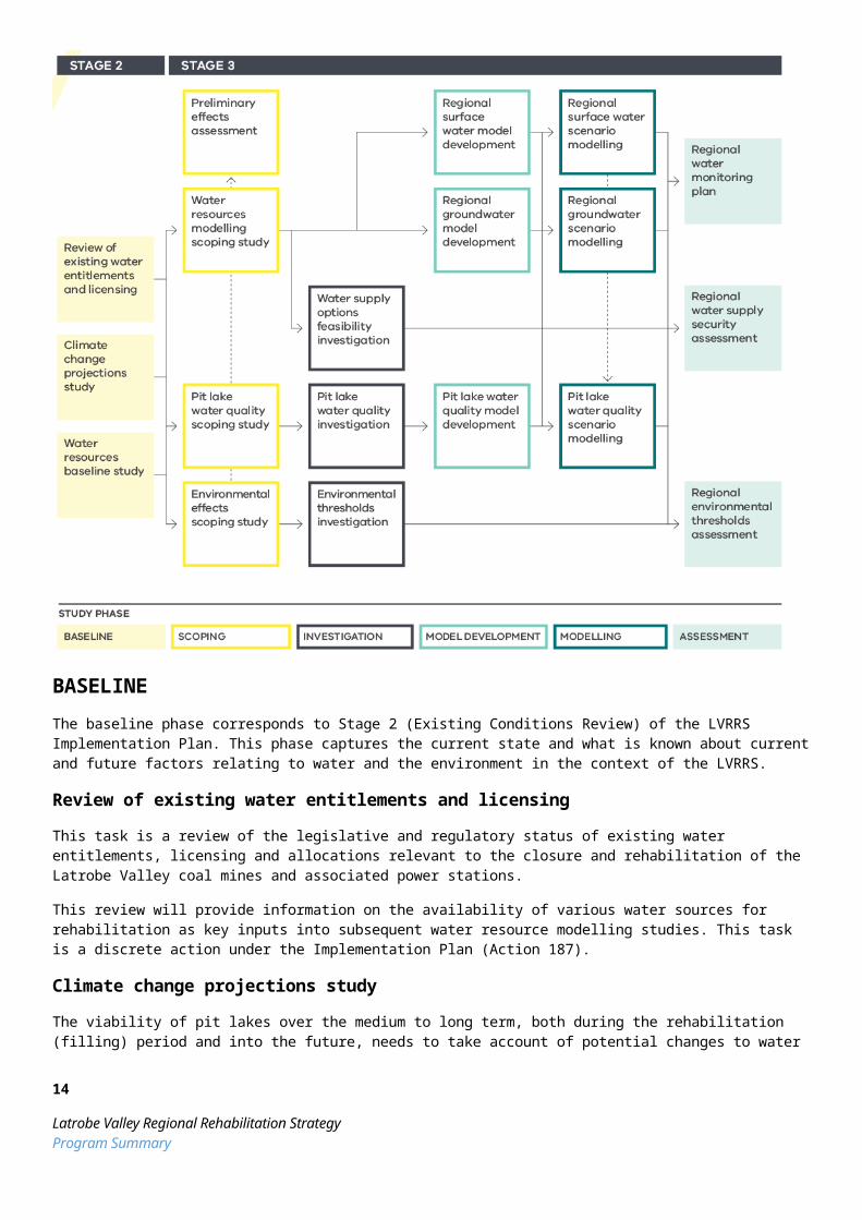
In order to answer these questions, the LVRRS will model surface water, groundwater and pit lakes under a range of rehabilitation scenarios and water source options, and compare the results with environmental and water demand thresholds on a regional, cumulative basis. There are a number of steps that are needed to complete this study, from baselining and scoping, through to additional investigation, model development, numerical modelling and finally assessment and reporting. These steps are summarised in Figure 5 and described below.
Figure 5: LVRRS water and environmental studies forming the regional water study (Stage 2/3)
10
Latrobe Valley Regional Rehabilitation StrategyProgram Summary
BASELINEThe baseline phase corresponds to Stage 2 (Existing Conditions Review) of the LVRRS Implementation Plan. This phase captures the current state and what is known about current and future factors relating to water and the environment in the context of the LVRRS.
Review of existing water entitlements and licensing
This task is a review of the legislative and regulatory status of existing water entitlements, licensing and allocations relevant to the closure and rehabilitation of the Latrobe Valley coal mines and associated power stations.
This review will provide information on the availability of various water sources for rehabilitation as key inputs into subsequent water resource modelling studies. This task is a discrete action under the Implementation Plan (Action 187).
Climate change projections study
The viability of pit lakes over the medium to long term, both during the rehabilitation (filling) period and into the future, needs to take account of potential changes to water availability as a result of climate change and long-term climate variability (such as periods of prolonged drought). However, understanding and predicting climate over such timeframes is highly uncertain, and different climate models can predict markedly different outcomes.
The climate change projections study will develop a sound basis for how climate change is to be dealt through the LVRRS studies, and how uncertainty and sensitivity to climate can best be captured in assessing the impacts and implications of various rehabilitation scenarios. This task is a discrete action under the Implementation Plan (Action 191).
11
Latrobe Valley Regional Rehabilitation StrategyProgram Summary
Water resources baseline study
A rigorous understanding of the water resources in the Latrobe Valley and how these are allocated and used by people and the environment is fundamental to the LVRRS.
This baseline study will compile existing knowledge and data sources on water allocation and use, water availability, water quality and aquatic ecosystems, for both surface water and groundwater, to inform subsequent water resource modelling and environmental studies. This task is a discrete action under the Implementation Plan (Action 188).
SCOPINGIn order to model and assess pit lakes and their impacts, it is necessary to understand the factors, processes and sensitivities applicable to these water systems. The scoping studies will develop an agreed, expert- and stakeholder-informed approach to how each component of the system should be studied, modelled and assessed. The scoping phase represents pre-work for Stage 3 (Modelling and Analysis) of the Implementation Plan.
Water resources modelling scoping study
To be able to model the system effectively on a regional basis, it will be necessary to establish a basis for integration of the different modelling platforms used by DELWP, the mine operators and their consultants, and to understand the limitations, capabilities and inter-operability of the integrated framework. This study will review the models and frameworks available for modelling surface water, groundwater and pit lakes, and develop a set of agreed conceptual models and a modelling framework for subsequent modelling studies.
Environmental effects scoping study
On a regional cumulative basis, rehabilitation of the Latrobe Valley’s coal mines has the potential to impact not just the upper Latrobe River where the mines are located, but also downstream environments including the broader Gippsland Lakes system.
The environmental effects scoping study aims to identify the main components of the Gippsland Lakes system relevant to the LVRRS, collate previous and current studies that could inform the LVRRS, and develop an action plan for any additional investigations that may be required to allow an assessment of potential impacts to be made as part of the regional water study.
Pit lake water quality scoping study
Predicting the chemical composition and behaviour of mine pit lakes is critical to the comparative assessment of different rehabilitation scenarios. Many factors and processes can affect the water quality of mine pit lakes, including the chemical composition of fill waters (e.g. groundwater or surface runoff), geochemical water–rock interactions, evaporative concentration, fresh water dilution and the physical and chemical behaviour of the lake during filling and once full. The pit lake water quality scoping study aims to bring together all of these factors into a consistent conceptual modelling framework utilising the latest methods and geochemical knowledge as the basis for subsequent modelling studies, and to identify the need for supplementary investigations to address important information gaps.
Preliminary water-related effects assessment
This task will integrate the scoping study findings to develop a preliminary understanding of the potential water-related effects of pit lake rehabilitation in order to determine whether there are any regional rehabilitation scenarios that are clearly not viable or feasible prior to detailed modelling and analysis.
INVESTIGATIONThe LVRRS will use existing information and data to the extent feasible to complete the technical studies. However, specific data gaps critical to completing key studies will be addressed as needed through supplementary investigations as part of Stage 3 of the Implementation Plan.
12
Latrobe Valley Regional Rehabilitation StrategyProgram Summary
Water supply options feasibility investigation
A comprehensive range of existing and alternative potential water sources for filling the mine pits will be canvassed as part of the water resource modelling scoping study. The water supply options feasibility investigation will explore these water sources in more detail to gain a clearer understanding of their comparative feasibility in terms of logistics, costs, infrastructure requirements, timing, availability, regulatory and licensing requirements, water quality and potential supply volumes.
Environmental thresholds investigation
This investigation will address critical data gaps identified through the environmental effects scoping study, such as the flow and water quality limits of representative sensitive components of the Gippsland Lakes system.
Pit lake water quality investigation
This investigation will address critical data gaps identified through the pit lake water quality scoping study, such as any water, overburden or coal sampling and analysis that may be needed to improve the prediction of pit lake water quality.
MODEL DEVELOPMENTOnce the conceptual models and data inputs have been established through the scoping studies and supplementary investigations, the selected models need to be either developed from scratch or adapted and refined from existing models for the purpose of modelling the specific rehabilitation scenarios to be considered in the LVRRS.
Regional surface water model development
This study will adapt and refine the surface water model selected through the water resources modelling scoping study for use in modelling of specific rehabilitation scenarios.
Regional groundwater model development
This study will adapt and refine the groundwater model selected through the water resources modelling scoping study for use in modelling of specific rehabilitation scenarios.
Pit lake water quality model development
This study will develop a uniform pit lake model to be used for all three mines as the basis for modelling of specific rehabilitation scenarios.
MODELLINGAfter the various modelling frameworks have been developed, tested and calibrated, they will be used to model the effects of rehabilitation under the various specific scenarios to be considered in the LVRRS, and to explore options for water supply and connectivity.
ASSESSMENTThe final assessment phase of the regional water study uses the results of modelling and analysis to assess the impacts of rehabilitation on regional water supply security and the environment, and to outline a water monitoring plan to track key performance outcomes focussing on gaps in existing monitoring networks/capabilities and options to address those gaps.
Land use Planning studiesThe Land Use Planning Studies are conducted in parallel with the other studies comprising the LVRRS and form a key input into the feasibility assessment and final Strategy, but have no direct links to Implementation Plan actions.
The key objective of the LVRRS land use studies is to ensure that the final safe, stable and sustainable rehabilitated sites are able to support productive and high-quality land uses which benefit the communities of the Latrobe Valley, Gippsland and Victoria. The studies will form a comprehensive land use strategy for the mine pits and surrounding areas which identify the potential land uses that may occur due to the pit lake landform scenario at an inter-mine, catchment and regional scale.
13
Latrobe Valley Regional Rehabilitation StrategyProgram Summary
As stated, it will qualitatively analyse the potential social and economic effects associated with identified land uses as well as potential regional measures that could be taken to avoid, minimise or enhance economic and social effects (e.g. changes in land use planning controls).
Working with the Latrobe City Council and other stakeholders, this study will develop a regional understanding of potential social and economic impacts of changes in land uses associated with biophysically feasible regional rehabilitation scenarios and their respective levels of community acceptability. Workshops and creative place-making sessions will be used to canvas broad options and opinions in the context of the findings of the LVRRS and government objectives within the Valley. The studies will consider how the rehabilitation of the three mine pits and surrounding areas may impact sites of heritage value, areas of environmental and state resource significance, physical infrastructure and current and existing urban growth patterns, including residential, industry and rural land uses at different spatial scales. The resulting land use strategy will have identified, evaluated and proposed productive land use changes to assist the Latrobe Valley economy in its transition and diversification, while adding benefits which are identified by the community.
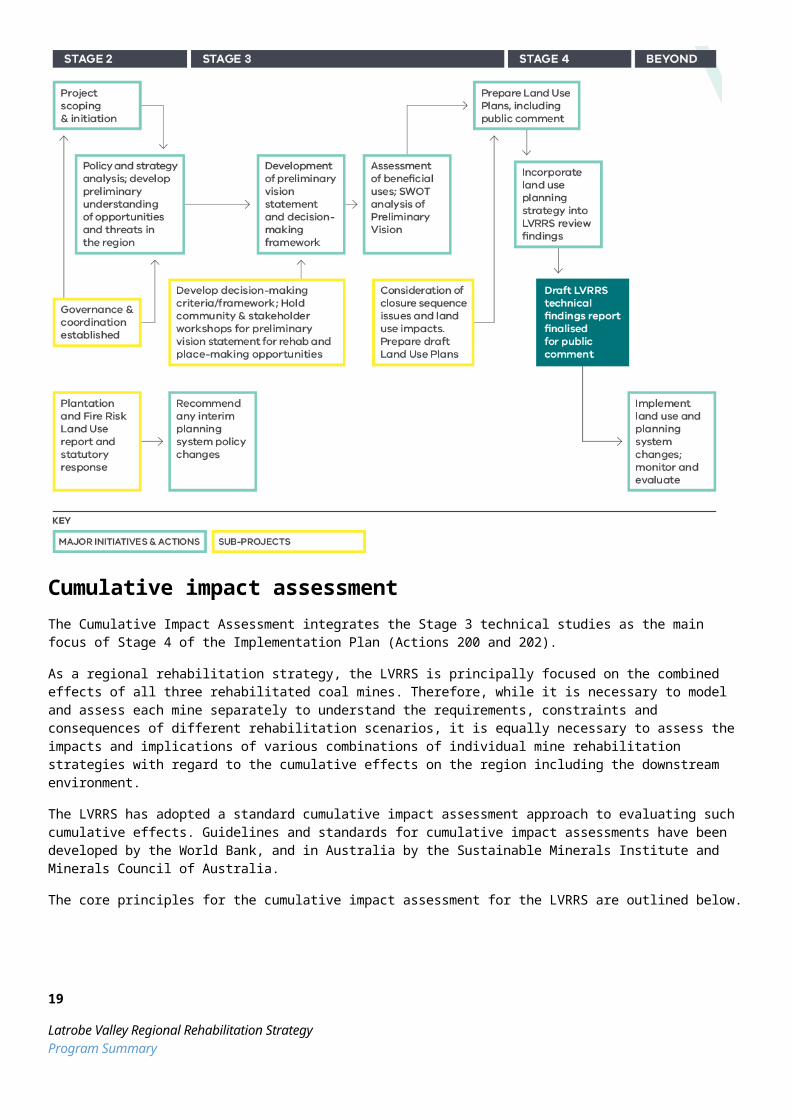
The activities conducted to date and planned for the land use project are aligned with the staging of the LVRRS project plan as described below and shown schematically in Figure 6.
STAGE 2Activities toward the land use strategy in Stage 2 were focused on project planning, ensuring that the project is aligned with the LVRRS project and its timelines, findings and engagement activities, and also with the establishment of the Latrobe Valley Authority and its activities to transition the local economy.
The output of this stage is a suite of project management documents and an approved path for decision-making in association with land uses and relevant state policies. The project plan considers aspects such as urban growth, and long-term industry and land use requirements, existing adjoining land uses and opportunities and constraints associated with pit lakes, and engagement processes to identify principles and a preferred preliminary vision for the Latrobe Valley mine sub-region.
STAGE 3Visioning and place-making exercises will be reviewed at the completion of LVRRS stages as appropriate. This will ensure an iterative response to the findings of the feasibility of pit lake options across all mine sites, noting inter-mine and regional land use implications. Liaison with the Latrobe Valley and broader Victorian communities, mine operators and other government departments will occur through this stage.
STAGE 4This stage will involve responding to the vision and principles established in Stage 3 and integrating these objectives and findings into the final LVRRS report. Critical decision making will be forwarded by the Minister for Planning as the ultimate decision maker regarding land use planning in the Latrobe Valley in accordance with the Minister’s responsibilities under the Planning and Environment Act 1987. Following this, the Strategy will be formally adopted and any identified planning system changes will be implemented.
Figure 6: Land use studies
14
Latrobe Valley Regional Rehabilitation StrategyProgram Summary
Cumulative impact assessment The Cumulative Impact Assessment integrates the Stage 3 technical studies as the main focus of Stage 4 of the Implementation Plan (Actions 200 and 202).
As a regional rehabilitation strategy, the LVRRS is principally focused on the combined effects of all three rehabilitated coal mines. Therefore, while it is necessary to model and assess each mine separately to understand the requirements, constraints and consequences of different rehabilitation scenarios, it is equally necessary to assess the impacts and implications of various combinations of individual mine rehabilitation strategies with regard to the cumulative effects on the region including the downstream environment.
The LVRRS has adopted a standard cumulative impact assessment approach to evaluating such cumulative effects. Guidelines and standards for cumulative impact assessments have been developed by the World Bank, and in Australia by the Sustainable Minerals Institute and Minerals Council of Australia.
The core principles for the cumulative impact assessment for the LVRRS are outlined below.
Source–Pathway–Receptor ModelImpacts are defined as the effect of one action or process on some other object, action, process or other thing of value. The origin of the impact is referred to as the source, and the impacted ‘thing’ is referred to as the receptor. In addition, for there to be an impact, there needs to be a causal link between the source and receptor, called the pathway.
For example, earthworks could be a source of sediment, a wetland could be a receptor, and downstream transport of sediment by erosion and deposition in the wetland could be a pathway by which the earthworks could impact the wetland.
15
Latrobe Valley Regional Rehabilitation StrategyProgram Summary
Regional Rehabilitation Scenarios (Source)The sources in the LVRRS cumulative impact assessment are the three mines, which have different rehabilitation modes, final landforms and rehabilitation timings under different regional rehabilitation ‘scenarios’. For the purposes of cumulative impact assessment, the three mines are regarded collectively as a single composite source under each scenario. The LVRRS will consider a manageable set of scenarios that test the main representative final landforms that could be practically achievable.
Recognised Regional Receptors (Receptors)There are many potential receptors relevant to the LVRRS, and not all could be reasonably addressed within the current timeframe for delivery of the LVRRS by June 2020. For this reason, the LVRRS has been designed to identify receptors of most value and significance for initial assessment, and of these, only those receptors with reasonable potential to be materially impacted by rehabilitation (a clear pathway) are subject to detailed impact assessment.
Recognised regional receptors are features of the region’s natural and built environment, natural resources and heritage that are considered to be important, through consultation with stakeholders and the community, in assessing the potential cumulative effects of mine rehabilitation.
Appropriate receptor metrics and thresholds will be defined and informed by existing published information and stakeholder consultation. Receptor metrics are the means by which impacts on receptors can be measured (e.g. changes in flow within a particular stretch of a river) and thresholds are the acceptable limits for each metric.
PathwaysThe impact pathways are many and varied, and will be explored through the LVRRS technical studies. The pathway determines the likelihood of event occurrence, which is considered in combination the consequence of an event occurring (i.e. severity of impact) to gauge the materiality of any given receptor for the purposes of the LVRRS.
Exogenous EffectsThe LVRRS cumulative impact assessment will also consider, to the extent practical given present knowledge, the effect of processes and plans beyond the scope of activities that could be controlled by the mine operators, such as climate change and long-term climate variability, and changes to regional land use including new economic activity.
Quantitative vs Qualitative ImpactsFor each regional rehabilitation scenario, the potential cumulative impacts on recognised regional receptors will be quantified where possible. Quantification of impacts will involve estimating the potential condition of receptors under different regional rehabilitation scenarios over short, medium and long terms. The potential condition of receptors will be compared with specified desired outcomes/thresholds for the acceptable condition of the receptor.
There will be instances of needing to qualitatively describe the potential effects on recognised regional receptors where there is a lack of agreed or valid quantitative information, or where such information may be difficult to acquire within the timeframe available for LVRRS development (to June 2020). If a recognised regional receptor is deemed to be of high importance and the LVRRS project concludes there is significant uncertainty regarding the extent of the effect on the receptor, the LVRRS may outline future actions (post June 2020) to improve the understanding of the potential effects of the regional rehabilitation scenarios.
Biophysical feasibility assessmentThe final technical output of the LVRRS is a statement of biophysical feasibility of a range of regional rehabilitation scenarios, fulfilling key components of Actions 201 and 203 of the Implementation Plan (Stage 4).
Preparation of the LVRRS will involve assessment of the biophysical feasibility of multiple pit lake landforms over the short, medium and long term on the basis of the regional geotechnical and water studies, the cumulative effects of the three coal mines on recognised regional receptors, and the land use studies.
The key focus for the LVRRS project will be the potential cumulative impacts on regional water resources and land stability associated with the proposed pit lake landforms.
16
Latrobe Valley Regional Rehabilitation StrategyProgram Summary
Water resource aspects includes likely demand for water to fill and maintain the pit lakes and the regional capacity to provide sufficient water (surface water and groundwater) in the context of climate change, the impacts of altering the existing water regime on regional water quality and flow, the effect on groundwater levels and associated impacts, and impacts on the Latrobe River, Lake Wellington, Gippsland Lakes and associated water-dependent ecosystems and cultural values.
Land stability aspects include the current and projected future state of features in proximity to the proposed pit lakes, their tolerance to ground movement, the potential likelihood and consequences of ground movement and what controls are required to avoid, mitigate and/or offset regional ground movement risk.
Biophysical feasibility statements will be produced for water, land stability and land use as key inputs into the final LVRRS, and will provide government and its agencies, stakeholders and the community with a clear understanding of the specific issues and considerations for each rehabilitation scenario.
The goal of the feasibility statements is to clearly define the regional rehabilitation scenario(s) and the recognised regional receptors for which:
Cumulative effects are acceptable (regional rehabilitation scenario(s) which are feasible)
Cumulative effects are not acceptable unless mitigated or offset, with some description of the mitigation measures or offsets that may be able to be adopted and what those measures could potentially be
Cumulative effects are unacceptable and cannot be mitigated or offset.
03 Stakeholder and community engagementEngagement strategyOpen and transparent engagement with the key stakeholders, including the Latrobe Valley community, is critical to the development of the LVRRS and is needed to build confidence in the strategy and its implementation.
The LVRRS Stakeholder and Community Engagement Strategy guides the engagement program that underpins the preparation of the LVRRS.
There a number of key stakeholders relevant to this project which are outlined on the next page.
Figure 7: Key stakeholder groups for the LVRRS
17
Latrobe Valley Regional Rehabilitation StrategyProgram Summary
Engagement activities for the LVRRS will take a ‘local first’ approach, recognising that it’s the people of the Latrobe Valley who have the most to gain or lose from the rehabilitation of the Latrobe Valley’s coal mines. There is also a need to engage more widely with stakeholders across Gippsland and Victoria, particularly in regard to the use of water resources for mine rehabilitation purposes.
An overarching aim for engagement activities for each of the four stages of the preparation of the LVRRS has been developed.
These aims, and the objectives that will ensure their successful delivery are articulated in the diagram on the next page.
Figure 8: Community and stakeholder engagement plan summary
18
Latrobe Valley Regional Rehabilitation StrategyProgram Summary
Latrobe Valley Mine Rehabilitation Advisory CommitteeTo support the delivery of the LVRRS, the Victorian Government has established the Latrobe Valley Mine Rehabilitation Advisory Committee.
19
Latrobe Valley Regional Rehabilitation StrategyProgram Summary
The Committee comprises representation from a broad range of stakeholder groups with an interest in mine rehabilitation in the Latrobe Valley.
The Committee will play a key role in community engagement and act a as conduit to broader stakeholder engagement during the life of the LVRRS.
The Committee will also provide advice directly to the Minister for Resources regarding the development of the LVRRS.
The Committee comprises membership from the following organisations and stakeholder groups:Chairperson, representing the Latrobe Valley community:
The Latrobe Valley Community
ENGIE Hazelwood
AGL Loy Yang
EnergyAustralia Yallourn
Latrobe City Council
Southern Rural Water
Gippsland Water
Aboriginal community
Department of Economic Development, Jobs, Transport and Resources
Department of Environment, Land, Water and Planning
Latrobe Valley Mine Rehabilitation CommissionerIn the final Volume of its 2015/16 Report, The Hazelwood Mine Fire Inquiry recommended the statutory appointment of a Latrobe Valley Mine Rehabilitation Commissioner.
Professor Rae Mackay was appointed as the inaugural Mine Rehabilitation Commissioner in 2017 and brings to the role more than three decades of experience as an engineer, hydrogeologist and academic both within Australia and internationally.
The Commissioner is independent and will lead and coordinate planning and improvements to mine rehabilitation in the Latrobe Valley.
The Commissioner will also provide advice on the development of policy, legislation and regulation relating to mine rehabilitation in the Latrobe Valley
The Commissioner’s objectives are to:
provide assurance to the community that the Government and the Latrobe Valley coal mine licensees are planning for the rehabilitation of coal mine land, and implementing the Latrobe Valley Regional Rehabilitation Strategy
promote active participation of community and stakeholders in the Latrobe Valley Regional Rehabilitation Strategy, and
promote the effective and consistent rehabilitation of coal mine land in accordance with the Latrobe Valley Regional Rehabilitation Strategy.
The Commissioner’s functions are to:
monitor and audit Latrobe Valley licensees’ rehabilitation activities
promote information sharing between parties
inform the general public of matters relating to coal mine rehabilitation
advise the Minister on the Latrobe Valley Regional Rehabilitation Strategy and post-closure maintenance of coal mining land, and
carry out investigations referred by the Minister.
20
Latrobe Valley Regional Rehabilitation StrategyProgram Summary
The Commissioner will also work with mine operators and Government departments and agencies to resolve rehabilitation issues as required.
04 Outcome for the communityThe aim of the Latrobe Valley Regional Rehabilitation Strategy is to set a safe, stable and sustainable landform for the Latrobe Valley coal mine voids and surrounding areas, providing assurance to the community. It will achieve this by exploring the effects and implications of a range of regional rehabilitation scenarios, providing government and the community with the information needed to make an informed decision regarding the future direction of mine rehabilitation and supported land uses.
Consistent with the Victorian Government’s commitment to an open and consultative process, community and stakeholder engagement during all four stages of the LVRRS will be key to informing the strategy. There will be a number of opportunities for the community and other key stakeholders to have input into the preparation of the strategy, including via the Latrobe Valley Mine Rehabilitation Advisory Committee, the Latrobe Valley Mine Rehabilitation Commissioner, stakeholder engagement activities including Open Days and Community Q&A sessions, as well as the technical studies that make up the LVRRS.
Information, updates and findings of the LVRRS will be published regularly on the LVRRS website:
http://earthresources.vic.gov.au/earth-resources/hazelwood/hazelwood-mine-fire-inquiry-implementation-plan/the-latrobe-valley-regional-rehabilitation-strategy
For further enquiries, please contact the LVRRS project team at [email protected]
21
Latrobe Valley Regional Rehabilitation StrategyProgram Summary