Embed Size (px)
Citation preview

Road Access a Burning Issue for Early Settlers of Inland TaranakiAn article prepared for the Institution of Professional Engineers of New Zealand,
Heritage Committee, on the use of “burnt papa” as a roading aggregate in the Whangamomona and Ohura Counties in the early 1900s.
Henry Bruce Dobson, Member
(County Engineer Taumarunui County 1979 – 1989, Chief Engineer Ruapehu District Council 1989 – 1998)
The Whangamomona and Ohura Districts were two of the last regions of New Zealand to be settled. Each District had its own County Council and both are located in the “papa” country of Inland Taranaki.
“Papa” is the Maori word for “earth” and the material referred to as “papa” is a mudstone which is a soft rock when excavated but which rapidly breaks down to a clay when exposed to the weather. The resulting clay becomes extremely puggy when wet and then bakes hard again when dried out in the summer; only to revert to pug again in the following winter. The mudstone is part of a vast deposit laid down in a geosyncline over a period of 150 million years and then thrust up to form the steep incised hill country of Inland Taranaki. Whangamomona is on the western side of the ranges and Ohura is on the eastern side.
Roading access was always a big issue for the two councils, but topography and geology conspired against any rapid advancement of the roading networks. Roadworks inevitably involved many sidling cuts, fillings and steep grades.
The Whangamomona area was (and still is) serviced via Stratford while the Ohura area is serviced from Taumarunui. Neither area has any significant deposits of local aggregate suitable for road building and any significant quantities required would need to be imported from Taranaki or Taumarunui. This was a particularly expensive operation in the early days given the distances involved, the nature of the access and early forms of transport. Consequently roads in the districts were usually just clay tracks. Because of the nature of the papa soils access was difficult for large parts of the year as the roads were either soft and puggy or hard and impossible to shape.
1
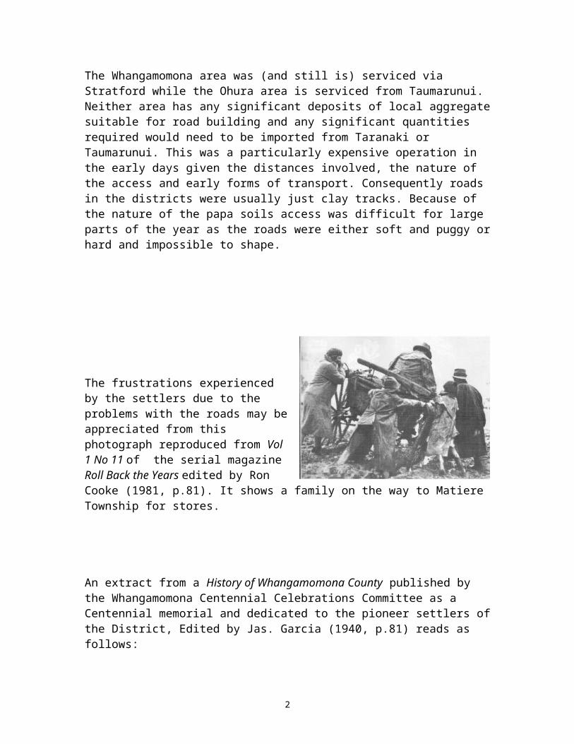
The frustrations experienced by the settlers due to the problems with the roads may be appreciated from this photograph reproduced from Vol 1 No 11 of the serial magazine Roll Back the Years edited by Ron Cooke (1981, p.81). It shows a family on the way to Matiere Township for stores.
An extract from a History of Whangamomona County published by the Whangamomona Centennial Celebrations Committee as a Centennial memorial and dedicated to the pioneer settlers of the District, Edited by Jas. Garcia (1940, p.81) reads as follows:"Keeping the clay roads at all passable for bullock teams was a difficult matter. In the winter the worst places had to be "corduroyed" with split slabs, or "fascined" with scrub, and even then bullocks got bogged, some even having their necks broken. In the dry weather these deep ruts dried up and became almost impossible to negotiate. Many devices were employed by Mr Nathan, Public Works overseer, to level the worst parts, including hauling heavy drag logs and a large wooden roller weighted with sacks of earth over the road before the clay became too dry."
The reference continues (p.81):"The eastern side of the Whangamomona saddle was the first road in the district to be metalled. As an experiment Mr Nathan erected kilns in which he burnt blue papa, spreading the resultant material on the road. It proved rather expensive, costing, it is said, £2 per yard. A simpler more economical method was used on the Marco road, where instead of constructing kilns, layers of wood and of blue papa were piled alternatively until there was a heap of sufficient size, when the wood was set alight and the heap allowed to burn itself out. The resultant blue papa, it is said, cost only 6/6 per yard. Burnt papa proved very serviceable as a road metal. Indeed, the red colouring on the road at the foot of the eastern side of the Whangamomona Saddle gives evidence that it has lasted to this day."
2

The photograph above is from p. 80 of the same reference and shows a papa burning “kiln”.
An article entitled "Taranaki's Red Brick Roads", in the Historic Places magazine (No 43, Sept 1993, pp36-38, author Ron Lambert) states:
"The first use of fired papa for roads appears to have been the notoriously unstable Alfredton to Weber road, east of Pahiatua, in 1894. Two "burns" totalling 412 cubic metres were made and some 500 m of road surfaced. The result of this trial gave rise to some optimism, although the Engineer’s report was, for the time, characteristically guarded.The following year, the Department of Lands and Survey in Taranaki reported its intention of using burnt papa as a substitute for metal or sand. William Nathan, the Public Works Overseer at Whangamomona, arranged the trials but it was noted, "the result has not been entirely satisfactory. The first firing was in an excavated kiln, building on the [roughly squared] papa blocks as in a brick kiln and then firing from below in the usual kiln manner.Although this method, similar to a brick clamp, used less wood for firing, the time and manpower needed to excavate and unload proved too costly and a second, and subsequently more widely used, kiln was employed. This was recorded in some detail.The method of burning papa is as follows:-The kilns are arranged in groups of three: one of them being filled while the second is being burnt and the third is being carted away onto the road. The kilns are usually about 24 feet by 18 feet, with walls 7 feet or 8 feet high, and are built in the open of blocks of ordinary papa, freshly quarried from suitable faces. To prevent wet weather interfering with the burning and chilling the papa, the kilns are roofed over with iron or light scantling on rough frames. The roof-ridges should be about 6 feet above the top of the papa. Fire-holes, usually 4 in number are run from the front to the back wall but not
3

through the wall. These fire holes average 1 foot 10 inches wide by 2 foot 10 inches high, and are arched with rough square blocks of papa. They should be strongly made, for upon them depends the success or otherwise of the burning. The walls - front, back and sides - are made of roughly-squared blocks. Under these walls and over the fire-holes the papa, in rough blocks suitable for lifting is piled up indiscriminately, for 2 feet or so above the walls. The accompanying diagrams show the general appearance of the kilns. The fires are then lit, wood from the adjoining bush being cut into 4 foot lengths and shoved into the fire-holes. The heat at first is mostly absorbed in drying the papa, but after a few hours of continuous stoking the heat becomes very great, and after thirty-six to forty-six hours of constant firing the top of the kiln is sealed with a foot or so of fine clay and the fire doors are plugged up. It takes about four days for the material to cool down before it is fit to handle. It is then carted on to the road, broken to proper size and spread on the road to depths varying from 6 inches to 12 inches. The colour of the material varies from terracotta to black. If sufficient thickness is put on a solid bottom it will, no doubt, make a first-class waterproof metalling for the road.”
The plans below, contained in the annual Report of the Land and Survey Department, (Appendix to Volume 2 of the Journal of the House of Representatives, 1901) show the procedure described above. (Images digitally enhanced for clarity.)
4

The first use of fired papa for roads is thought to have been in the Wairarapa and evidence of the use of the practice in the Wairarapa is supplied by Des Lovatt (former research engineer, with the Ministry of Works and Development), who commented “The only stuff I remember about burnt papa was the use of it in the Eketahuna and/or Pahiatua area. The County Overseer in about 1984 sent me a sample he had dug up during a road repair (which I probably still have wrapped in newspaper in a box somewhere)”.
The Historic Places Trust article continues:“Even this labour-intensive method was later replaced with "face kilns" which were vertical hollows blasted from a papa face. Alternative layers of timber and papa were then built up, fired and covered with earth.
The procedure in papa burning required a moderate papa bluff perhaps 20 feet or 30 feet high topped by a supply of beach (sic) trees, Tawhai and Tawhera. The trees would be fallen and rolled and stacked at the foot of the bluff so as to form a complete burning bed. On to the fallen trees papa would be broken out from the bluff until a suitable layer had completely covered the timber. More timber would be fallen over the papa and the head lighted.
This appears to have been the method used in the Wairarapa which was subsequently used on Mount Messenger (North Taranaki) and in the Ohura area at Tokirima and Niho Niho.
One of the last major papa burning contracts was let by the Whangamomona Country Council as late as 1921. This contract, for the surfacing of several kilometres of the Marco Road set specifications for the contractors:
The kilns will be placed on the road clear of traffic. A base of logs will be put down alongside each other to consist of timber which will not easily burn and which will serve as a platform to keep the kiln dry and clear of the ground. On this platform will be laid a layer of good burning timber such as rata or tawa and then a layer of papa lumps. The timber will be spaced to allow air to ventilate up as the burning proceeds. The thickness of the papa layer must not exceed the thickness of the timber on which it rests. The timber will be arranged cross wise, like a grid and the whole kiln will be made in this way to a height not exceeding 20 feet.”
(See the photograph on the next page for a kiln built in this fashion in the Ohura area – not part of the above contract.)
Vivid memories are held by residents of the former Ohura County, which amalgamated with the Taumarunui County Council in 1956 and subsequently became part of the Ruapehu District Council in 1988. Roll Back the Years, Volume 1 No 14 May 1981 edited by Ron Cooke contains an item entitled "In Lieu of Stone…" (p.118). The following extract is taken from that item.
"Today there is still a stretch of road at Niho Niho from the Rosevear property to Jim Mossman’s on the Waikaka road where the characteristic red, brick like appearance can
5

be seen. It is believed that the first papa was laid in the Niho Niho area, but unfortunately County graders have done their damage.
Opinions differ as to the value of papa thus treated, but the Ohura’s experience has been altogether in favour of its durability.
It would appear that the actual method of preparing the papa differed in different circumstances. The method shown in the photograph (on the following page) was to make up rough platforms of logs with open spaces left at intervals. On this the papa was piled in chunks. The open spaces were filled with more logs and then the platform was fired, burning something after the manner of a brick kiln.
One writer of the day said ‘To see the workmen preparing the thing reminds one of Homer's descriptions of the building of a funeral pyre.’
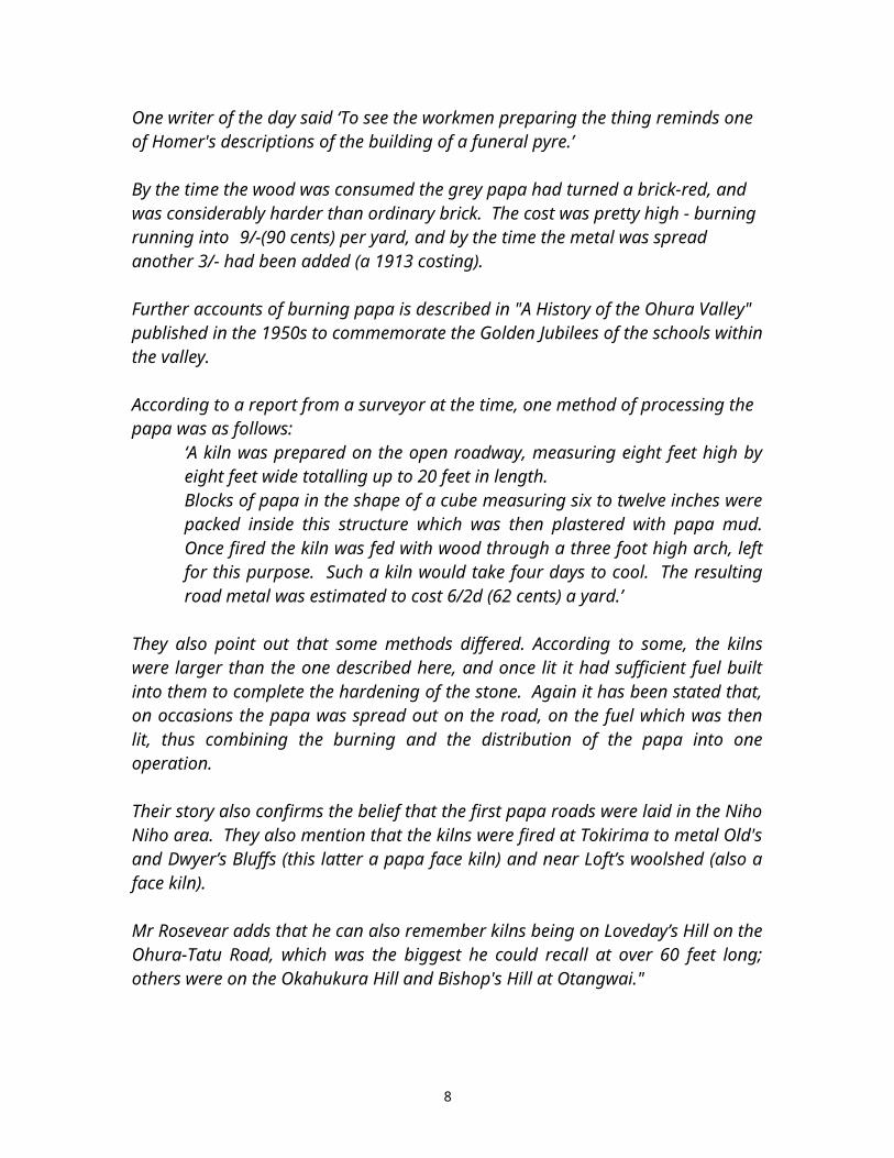
By the time the wood was consumed the grey papa had turned a brick-red, and was considerably harder than ordinary brick. The cost was pretty high - burning running into 9/-(90 cents) per yard, and by the time the metal was spread another 3/- had been added (a 1913 costing).
Further accounts of burning papa is described in "A History of the Ohura Valley" published in the 1950s to commemorate the Golden Jubilees of the schools within the valley.
6

According to a report from a surveyor at the time, one method of processing the papa was as follows:
‘A kiln was prepared on the open roadway, measuring eight feet high by eight feet wide totalling up to 20 feet in length.Blocks of papa in the shape of a cube measuring six to twelve inches were packed inside this structure which was then plastered with papa mud. Once fired the kiln was fed with wood through a three foot high arch, left for this purpose. Such a kiln would take four days to cool. The resulting road metal was estimated to cost 6/2d (62 cents) a yard.’
They also point out that some methods differed. According to some, the kilns were larger than the one described here, and once lit it had sufficient fuel built into them to complete the hardening of the stone. Again it has been stated that, on occasions the papa was spread out on the road, on the fuel which was then lit, thus combining the burning and the distribution of the papa into one operation.
Their story also confirms the belief that the first papa roads were laid in the Niho Niho area. They also mention that the kilns were fired at Tokirima to metal Old's and Dwyer’s Bluffs (this latter a papa face kiln) and near Loft’s woolshed (also a face kiln).
Mr Rosevear adds that he can also remember kilns being on Loveday’s Hill on the Ohura-Tatu Road, which was the biggest he could recall at over 60 feet long; others were on the Okahukura Hill and Bishop's Hill at Otangwai."
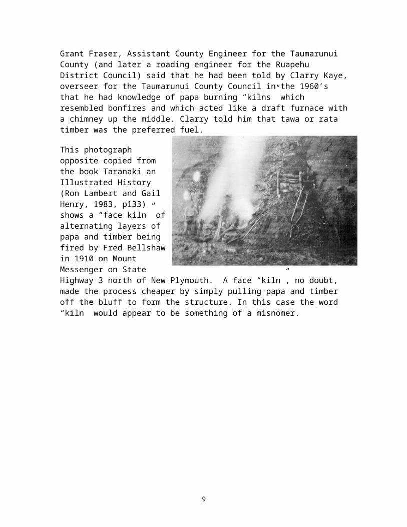
Grant Fraser, Assistant County Engineer for the Taumarunui County (and later a roading engineer for the Ruapehu District Council) said that he had been told by Clarry Kaye, overseer for the Taumarunui County Council in the 1960’s that he had knowledge of papa burning “kilns” which resembled bonfires and which acted like a draft furnace with a chimney up the middle. Clarry told him that tawa or rata timber was the preferred fuel.
This photograph opposite copied from the book Taranaki an Illustrated History (Ron Lambert and Gail Henry, 1983, p133) shows a “face kiln” of alternating layers of papa and timber being fired by Fred Bellshaw in 1910 on Mount Messenger on State Highway 3 north of New Plymouth. A face “kiln”, no doubt, made the process cheaper by simply pulling papa and timber off the bluff to form the structure. In this case the word “kiln” would appear to be something of a misnomer.
7
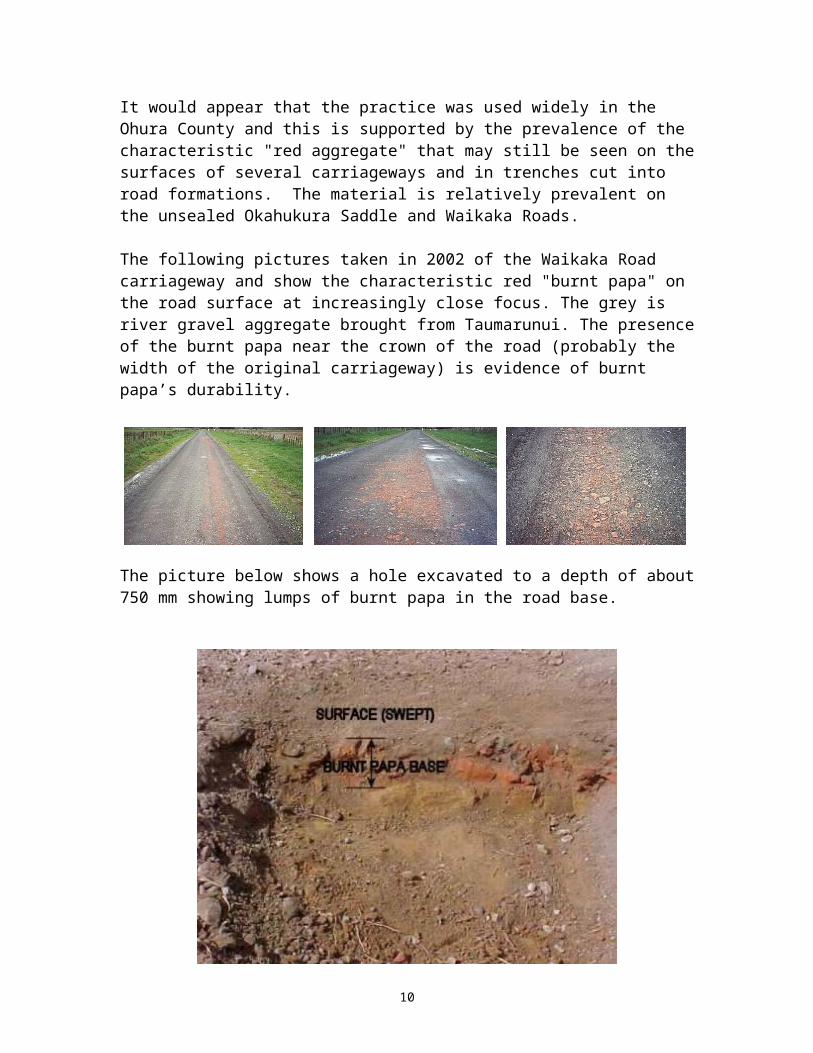
It would appear that the practice was used widely in the Ohura County and this is supported by the prevalence of the characteristic "red aggregate" that may still be seen on the surfaces of several carriageways and in trenches cut into road formations. The material is relatively prevalent on the unsealed Okahukura Saddle and Waikaka Roads.
The following pictures taken in 2002 of the Waikaka Road carriageway and show the characteristic red "burnt papa" on the road surface at increasingly close focus. The grey is river gravel aggregate brought from Taumarunui. The presence of the burnt papa near the crown of the road (probably the width of the original carriageway) is evidence of burnt papa’s durability.
The picture below shows a hole excavated to a depth of about 750 mm showing lumps of burnt papa in the road base.
8
Collected samples of “burnt papa” are shown in the photograph below:
The former Department of Lands and Surveys cadastral maps of the area show special reserves set-aside for the burning of papa. A copy of a section of part of a cadastral map of the Ohura area is reproduced below and shows the Papa Reserves highlighted yellow.
9
In all seventeen papa burning reserves were created in the Ohura, Mahoe and Pouatu Survey Districts.
Ron Lambert reports other remaining evidence of papa burning on p38 of his Historic Places article.
“Patches of red-fired papa can be seen on a considerable length of the Marco Road. It could be seen on the Tahora Saddle stretches of State Highway 43, until the road was reconstructed and sealed in the late 1980s. In 1988, grading in the area revealed, temporarily, three roughly rectangular “patches” of fired papa, presumably the site of kilns.A more substantial kiln site 1.5 kilometers west of Whangamomona township is situated in a small gully fifty meters off State Highway 43. This site consists of a papa quarry from which a track leads twenty to twenty five metres to the firing site. A tunnel flue connects the kiln site with the floor of the quarry four metres above. Its position – off the road – and the presence of the flue suggests this may well be the site of Nathan’s 1998 “excavated” kiln.”
The construction of the Stratford to Taumarunui (Okahukura) railway line eventually enabled the transportation of river gravel from Taumarunui and Taranaki to the Ohura and Whangamomona Counties. The first sod of the railway line was turned in Stratford in March 1901, but the last spike was not driven until the 7th of November 1932.
As the road foundations and road transport improved, increasing quantities of roading metal were transported using trucks. The "Fifties" and the "Sixties" saw extensive metalling and seal extension programmes based on the use of bottom dump trucks. By the 1980s the road foundations and alignments had improved significantly and allowed the use of truck and trailer units which were more versatile then bottom dumpers.
The "papa country" continues to present roading challengers. Papa bluffs which are solid when constructed often become unstable as the banks weather, fritter and spall and can present an ongoing maintenance problem and a potential hazard. The 1980s saw the need to undertake major reconstruction of the Te Maire and Hurlihy’s Bluffs to reduce the batter angles and provide a barrier to falling rocks. This work followed the death of a young farm worker Lance Buchanan who was struck by a block of papa when travelling as a passenger in a car past Herlihey’s Bluff.
Dobbs Bluff on the Oio Road in the Kaitieke area can be a particular problem and a potential danger to travellers. The road past this bluff is a narrow ledge between the 30m high bluff above and a 30m drop to the Retaruke River below. It is not unusual for large blocks and/or slabs of papa to come crashing onto the road surface in amounts up to several tonnes at a time.
The 1980's and 1990’s also saw a push by the Councils for roading improvements and seal extension to State Highway 43 which passes through Whangamomona. At this stage, all but the section of this Highway through the Tangarakau Gorge is sealed.
10

“Burnt papa” has undoubtedly made a useful contribution to the development of New Zealand’s roading infrastructure and may be seen as another “number 8 wire solution” for which pioneering New Zealand has become so renowned. Evan as late as 2001 the New Zealand Mining Journal contains the following reference. “Historically, some hinterland roads e.g. between Stratford and Ohura, were constructed using burnt “papa” or siltstone.” (Volume 30 December 2001 p18).
Acknowledgements
Grant Fraser Assistant County Engineer for the Taumarunui County Council and later a roading engineer for the Ruapehu District Council, for his assistance with sourcing photographs and maps for this article and for proof reading the article from the basis of his knowledge.
Ron Cooke, historian and publisher, for the use of photographs and material from his serial publication Roll Back the Years and for proof reading this article from the basis of his knowledge.
Rob. Merrifield, Technical Auditor, Transfund New Zealand, for his suggestion that this item be prepared for the IPENZ Heritage Committee.
References"MapPoint, map" Microsoft® Encarta® 2002 MapCenter. http://encarta.msn.com/encnet/features/MapCenter/Map.aspx © 1993-2002 Microsoft Corporation. All rights reserved.
Editor, Ron Cooke. (1981 – 1987). Roll Back the Years. Taumarunui: C&S Publications
Editor, Jas Garcia. (1940). History of the Whangamomona County. New Plymouth: The Taranaki Daily News Coy., Ltd.
Ron Lambert. Historic Places magazine No 43, (Sept 1993, pp36-38,)
Annual report of the Department of Lands and Survey (Appendix to Volume 2 of the journal of the House of Representatives, 1901).
Ron Lambert and Gail Henry. Taranaki an Illustrated History. First published, Palmerston North: Dunmore Press. (1983).
Tony Christie, Bruce Thompson and Bob Braithwaite, Institute of Geological and Nuclear Sciences Ltd. Mineral Commodity Report, New Zealand Mining Volume 30 (December 2001 pp6 – 25).
February 03
11