Embed Size (px)
Citation preview

®
QUAlity aware VIsualisation for the Global Earth QUAlity aware VIsualisation for the Global Earth Observation system of systemsObservation system of systems
Reading meeting. December 12-14th, 2011
University of Reading meeting
December 12-14th, 2011 Reading UK

Reading meeting. December 12-14th,
2011
2
University of Reading
• 2 mornings+ 2 afternoons in a 3 day meeting
DecemberMonth 11
July 2011Month 6
February 2011Month 1

®
QUAlity aware VIsualisation for the Global Earth QUAlity aware VIsualisation for the Global Earth Observation system of systemsObservation system of systems
Reading meeting. December 12-14th, 2011
Introduction.
Reading meeting. December 12-14th,
2011
4
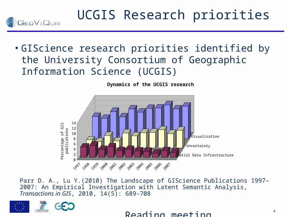
UCGIS Research priorities
• GIScience research priorities identified by the University Consortium of Geographic Information Science (UCGIS)
Parr D. A., Lu Y.(2010) The Landscape of GIScience Publications 1997–2007: An Empirical Investigation with Latent Semantic Analysis, Transactions in GIS, 2010, 14(5): 689–708
0
2
4
68
10
12
14
Per
cen
tag
e o
f G
IS
pu
blic
atio
ns
1997
1998
1999
2000
2001
2002
2003
2004
2005
2006
2007
Spatial Data Infrastructure
Uncertainty
Visualization
Dynamics of the UCGIS research

Reading meeting. December 12-14th,
2011
5
This is still a GEOSS project
• New on the GCI– Discovery and download of broader and more heterogeneous
datasets by connecting existing data sharing systems (i.e. EuroGEOSS and GENESI DEC/FedEO) with the GCI that allows• transverse data discovery from data catalogues outside of GEOSS
registries (supported by the broker functionality and the Earth Observation Common Vocabulary (EOCV))
• direct download of data sets.
• GEO is in a transition to a new structure. All committees and tasks are gone (ADC, STC, ST-09-02) and a new structure is emerging.

Reading meeting. December 12-14th,
2011
6
GEOSS Infrastructure Enhancements
Services: Catalog, Access,
Processing
Inventory Access*
EO Data Applications: Web and PC
Brokered Search:EuroGEOSS*,
GENESI*, CWIC*
Brokered Search:EuroGEOSS*,
GENESI*, CWIC*
GEOSS Registration
Service (CSR)
GEOSS Registration
Service (CSR)Standards and Interoperability
Registry
Standards and Interoperability
Registry
Best Practices
Wiki
Best Practices
Wiki
ClearinghouseClearinghouseEO Vocabulary*EO Vocabulary*
GEOSSCommonInfrastructure
* Prototype capabilities
GEO WebPortal
Service Monitoring*
Service Monitoring*

Reading meeting. December 12-14th,
2011
7
Growth of Registered/Accessible Resources
DataData products*products*
year
Number
Earth Earth Observation Observation SystemsSystems
ServicesServices
2011(Nov.)2011 (Sept.)2010
500
141
90,909
28,000,000+
1,000
1,500
191
1492
1500+
43
500+
381
10,000
1,000,000
100,000
10,000,000*via CEOS CWIC client integration
100,000,000
Data SetsData Sets

Reading meeting. December 12-14th,
2011
8
A 3 days event. Main Objectives
• Second phase on GeoViQua Quality Model
• Start almost everything– Components for Quality elicitation– Components for Search– Components for Visualization
• Close the main phase of requirements
• Definition of scenarios

Reading meeting. December 12-14th,
2011
9
A 3 days event. Timeline
• Day 12 Afternoon ESSC Conference Room(Focus on preparing the work to do and inspiration for the next day)– Quality model, Requirements– Visualization, GEOLabel– GCI (GEO Portal duplicate and EuroGEOSS broker– Introduction to scenarios
• Day 13 Morning Meterology Dept. (Split sesions)– Quality inference ROOM_A(1L43) or Quality extraction ROOM_B(1L61)
– Quality visualisation ROOM_A(1L43) or Quality search ROOM_B(1L61)
– 3 Scenarios 1L43 plenary+split– 3 Scenarios ROOM_B(1L61) or Philosophical Transactions Paper Room A (1L36) – Components design revisited based on scenarios 1L43
• Day 14 Morning Henley Business School, Room 102 – Current status of the GEOSS quality Metadata– Requirements – Review strategy for next deliverables and final comments

Reading meeting. December 12-14th,
2011
10
Day 12 Afternoon. - ESSC Conference Room
• 14:00_14:15 Jon Blower Welcome • 14:15_14:25 Joan Masó Introduction • 14:25_14:45 Joan Masó Review of the project WP by active tasks, next
deliverables, next milestones, small teams • 14:45_15:15 Kevin Yang Quality data model definition for GeoViQua and GEOSS
Discussions on the Quality data model that will be adopted in the project • 15:15_15:30 Jon Blower Visualization in GeoViQua • 15:30_16:05 SC-ESA The copy of the GCI for our eyes only
• 16:05_16:20 Coffee break
• 16:20_16:50 Lorenzo Bigagli GEO User interfaces (search, visualization, and user feedback). (Based on an EuroGEOSS? broker demonstration and more ideas)
• 16:50_17:20 Victoria GEO Label. Review of the questionnaire and measures to stimulate participation
• 17:20_17:35 Simon Thum Requirements; current status and Wednesday preparation
• 17:35_18:00 Eva Sevillano Introduction of the GeoViQua 3 Scenarios • • Evening Table booked for 17 people at Sizzling Spice at 19:30 (very close to University)

Reading meeting. December 12-14th,
2011
11
Day 13 Morning - Meterology Dept. 1L43
• 09:00_09:20 Joan Masó Components model presentation 1L43 • 09:30_10:50 Dan Cornford Quality inference ROOM_A(1L43)• 09:30_10:50 Joan Masó Quality extraction ROOM_B(1L61)
• 10:50_11:10 Coffee break
• 11:10_12:30 Jon Blower Quality visualisation ROOM_A(1L43)• 11:10_12:30 Lorenzo Bigagli Quality search ROOM_B(1L61)
• 12:30_13:30 Lunch

Reading meeting. December 12-14th,
2011
12
Day 13 Afternoon - Met. Dept. 1L43
• 13:30_15:30 Eva Sevillano GeoViQua 3 Scenarios 1L43 Plenary• 15:30_15:45 Coffee break • 15:45_17:00 Eva Sevillano GeoViQua 3 Scenarios 1L43 Plenary
• 17:00_17:10 Break to change rooms
• 17:10_18:00 Kevin Progres on Royal Society Philosophical Transactions Paper Room A(1L36) Split
• 17:10_18:00 Eva Sevillano GeoViQua 3 Scenarios Room B(1L43) Split• 18:00_18:30 Joan Masó Components design revisited based on
scenarios and assign responsibilities 1L43 Plenary
• Evening Dinner
Reading meeting. December 12-14th,
2011
13
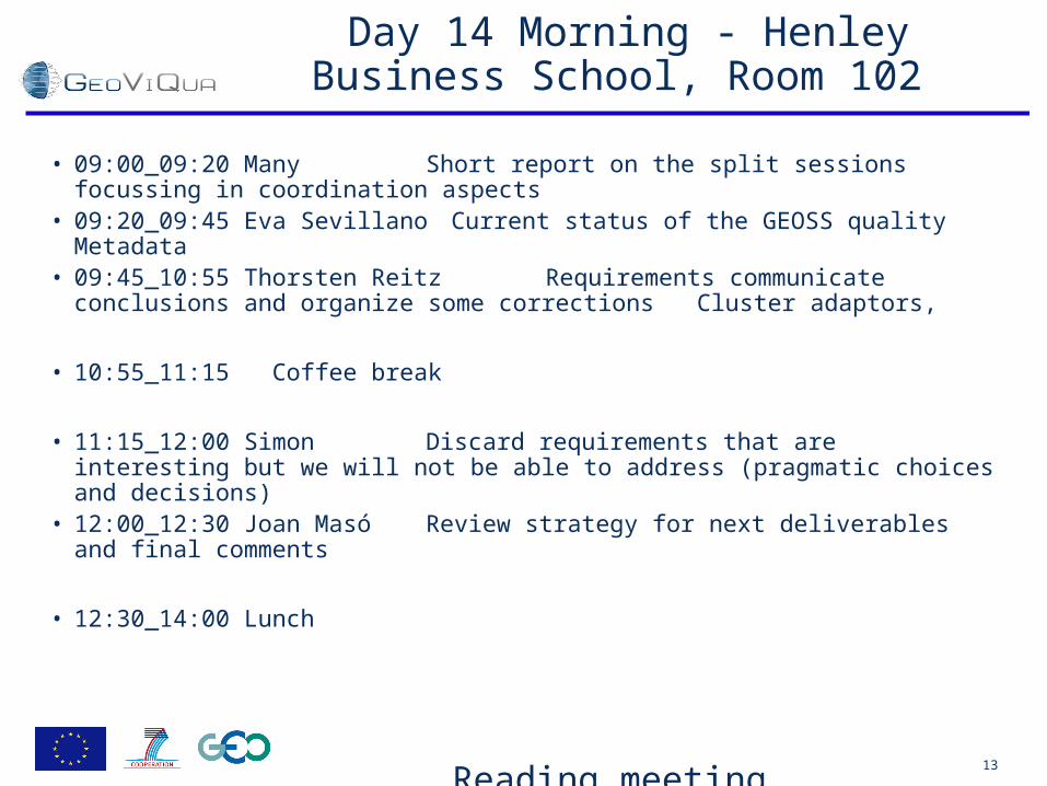
Day 14 Morning - Henley Business School, Room 102
• 09:00_09:20 Many Short report on the split sessions focussing in coordination aspects
• 09:20_09:45 Eva Sevillano Current status of the GEOSS quality Metadata
• 09:45_10:55 Thorsten Reitz Requirements communicate conclusions and organize some corrections Cluster adaptors,
• 10:55_11:15 Coffee break
• 11:15_12:00 Simon Discard requirements that are interesting but we will not be able to address (pragmatic choices and decisions)
• 12:00_12:30 Joan Masó Review strategy for next deliverables and final comments
• 12:30_14:00 Lunch

Reading meeting. December 12-14th,
2011
14
Agenda last minute items
• The agenda for today:– http://twiki.geoviqua.org/twiki/bin/view/ GeoViQuaIntranet / PTBMeeting03
• Is there any last minute items to be included in the agenda?
• Who is taking minutes?

®
QUAlity aware VIsualisation for the Global Earth QUAlity aware VIsualisation for the Global Earth Observation system of systemsObservation system of systems
Reading meeting. December 12-14th, 2011
The project
Joan Masó (CREAF)

Reading meeting. December 12-14th,
2011
16
The aim
GeoViQua will provide a set of scientifically developed software components and services that facilitate the creation, search and visualization of quality information on EO data integrated and validated in the GEOSS Common Infrastructure.
Pilot case studies
CC RR OO SS SS
SS BB AA
Communitybuilding
GEO S&T Label

Reading meeting. December 12-14th,
2011
17
Project objectives
• 1. Provision of innovative tools to enhance the current infrastructure capability. – GeoViQua’s major technical innovation is search and visualization tools for
the community which communicate and exploit data quality information from GEOSS catalogues.
• 2. Development of the GEOLabel. – GEOLabel requirements are identified (Work Package WP2), integrated with
components (WP6), validated and applied into pilot cases (WP7), and disseminated to the community (WP8). It will be completed in collaboration with the GEO task ST-09-02.
• 3. Harmonization, exploitation and dissemination of project outputs. – A careful validation process is conducted in collaboration with a number of
communities of practice and standards committees to ensure that the project contributes effectively to the GCI architecture. Collaboration to AIP will be continuous.

Reading meeting. December 12-14th,
2011
18
• Enhanced geo-search tools– Quality-aware catalogue service – Quality-aware catalogue client
• Quality aware visualisation components– Integrate of quality information – Show the quality information
• This main 3 WP have started or are starting today.
Project structure
Delivery of solutions to end users
Data quality elicitation mechanism
Enhanced geo-search
tools
Quality aware visualisation
tools

®
QUAlity aware VIsualisation for the Global Earth QUAlity aware VIsualisation for the Global Earth Observation system of systemsObservation system of systems
Reading meeting. December 12-14th, 2011
Some informative topics

Reading meeting. December 12-14th,
2011
20
EuroGEOSS conference
• Advancing the vision for GEOSS• January 25th to 27th. Madrid• ~40 presentations
• Two GeoViQua presentations– Friday January 27, 2012 – Salón de Actos– Session 10: Data Quality And Biodiversity- Chair Javier Nogueras
• GEOSS Quality Framework and Quality Information Encoding Xiaoy Yang et al. (11:20)
• Analysis of the Quality Metadata in GEOSS ClearinghouseEva Sevillano et al. (11:40)

Reading meeting. December 12-14th,
2011
21
Arch. Implementation Pilot 4 and 5 participation
• Participation in AIP4 as a coordinated effort to produce a tutorial on data quality. The team was formed by GeoViQua, QA4EO and ESIP IQ cluster. – Currently this means: CREAF (Joan Masó), ASTON (Dan Cornford) and
NASA (Gregory Leptoukh) with Veronica Guidetti (as an observer)
• We fail to generate momentum and to write the tutorials for different reasons
• The SIF is still interested in having our tutorials in the BPW– http://wiki.ieee-earth.org/Documents/GEOSS_Tutorials
• We will be able to reformat the deliverable D6.1 Data quality encoding as a best practice paper Month 15: April 2012
• AIP4 has ended.
Reading meeting. December 12-14th,
2011
22
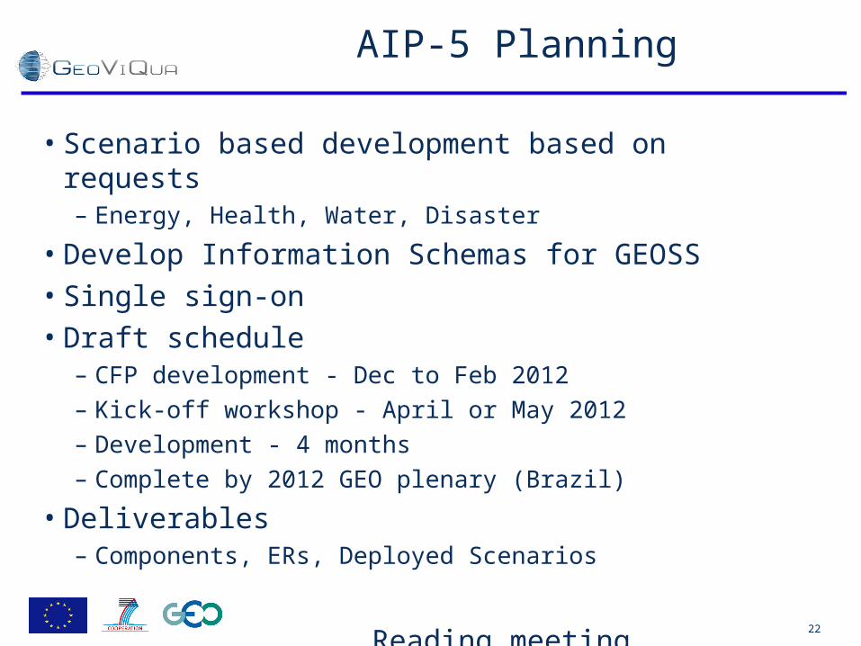
AIP-5 Planning
• Scenario based development based on requests – Energy, Health, Water, Disaster
• Develop Information Schemas for GEOSS • Single sign-on • Draft schedule
– CFP development - Dec to Feb 2012 – Kick-off workshop - April or May 2012 – Development - 4 months – Complete by 2012 GEO plenary (Brazil)
• Deliverables – Components, ERs, Deployed Scenarios

Reading meeting. December 12-14th,
2011
23
Possible OWS-9 activities
• Quality encodings– Producer created quality information is supposed to be encoded on metadata as
quality measures as well as conformity to some rules using 19139 XML encodings.– An alternative encoding is provided by UncertML (An old public discussion paper in
OGC)– Provenance is seen as part of the quality information (ISO19115 Lineage is an
alternative, W3Cprov is another alternative)– User feedback about datasets and peer review are other information that could be
included as quality.
• The state of the art in OGC– Almost no reference in service standards about how to relate data and quality. Links to metadata
elements is a possibility but no real examples are provided.– Situation in encoding standards like GML or KML.– Some profiles for WMS or other OWS services but there is no profile on how to communicate
data with data quality.– WCS 2.0 general structure mentioned an extension for an uncertainty coverage in WCS but this
is not available– WPS implementations provide access to any kind of models but no reference on how to
communicate provenance on results or how to input and propagate uncertainties to the outputs (Some old OWS-x edition experimented with this)
– OWS Context standard provide another way to associate data to other information in the same view but no quality scenario has been considered so far.
OGC®

Reading meeting. December 12-14th,
2011
24
Quality viewer scenario
• A integrated client wants to show data and quality/provenance at the same time.– Data quality indicators and flags
• Product/dataset/sensor level quality as text data• Pixel/feature quality in the map view
– As extra style– In a synchronized window
– Provenance as a tree or network• It is possible to show/switch the source data from the provenance tree.
• Relevant services– WMS, KML clients
• Deliverables– Quality encoding for WMS and KML ER– Quality enable integrated client able to render data, quality indicators,
quality flag parallel datasets, provenance tree/network representation (workflow)
OGC®

Reading meeting. December 12-14th,
2011
25
Quality propagation scenario
• The central element or the scenario is a WPS chain that is able to propagate quality in processes execution.– Reads data quality from other services– Encodes output resulting data quality– Involves multipart input and output
• data + metadata + quality + provenance
• Services involved– WFS that could encode quality in GML or in independent metadata– WCS (uncertainty extension) as input– WPS quality enabled
• Deliverables– WCS uncertainty extension ER– Quality enable WFS (+GML schema) ER– WPS quality propagation + provenance implementation with multipart files.
OGC®

Reading meeting. December 12-14th,
2011
26
Participation in OWS-9 (or OWS-10)
• GeoViQua aims to provide some tools on quality visualization with the data and data search filtered and raged by quality, but first there is a need have a clear way to easily expose data quality in OGC services and encodings.
• We offer a small monetary sponsorship and also one person of the CREAF staff to participate/lead some activity on data quality in-kind. Other partners in the project could also participate in-kind but this has to be confirmed.
• NRCan, NGA and FAA has expressed interest in the provenance/propagation scenario and could finance some participation.
OGC®

Reading meeting. December 12-14th,
2011
27
OWS-9 Preliminary ScheduleOWS-9 Preliminary Schedule
© 2011 Open Geospatial Consortium© 2011 Open Geospatial Consortium
• Contact: –Nadine Alameh, nalameh at opengeospatial.org –George Percivall, gpercivall at opengeospatial.org
OGC®

®
QUAlity aware VIsualisation for the Global Earth QUAlity aware VIsualisation for the Global Earth Observation system of systemsObservation system of systems
Reading meeting. December 12-14th, 2011
Where we are

Reading meeting. December 12-14th,
2011
29
Starting an important period
Start PrototypesValidation
Mobile Solutions
Search & Visualization
Data ready
Quality recommendations
Quality parameterization
Pilot cases
User & technical requirements to CoP
User & technical solutions to CoP
Workshops
Proposals evaluation Final documentGeoLabel
Metadata extraction
Best practices quality encoding
Direct extraction from continuous variables
Quality elicitation User feedbackExtraction from categorical variables
1 2 3 4 5 6 7 8 9 10 11 12 13 14 15 16 17 18 19 20 21 22 23 24 25 26 27 28 29 30 31 32 33 34 35 36
Febr
uary
201
1
Janu
ary
2012
Janu
ary
2013
Dec
embe
r 201
3
2014

Reading meeting. December 12-14th,
2011
30
Next deliverables
• D3.1 Metadata extraction quality component – Month 12 January 2012 (CREAF)
• D7.2 Report on current GCI and identification of issues in integration with GEOSS – Month 12 January 2012 (UAB)
• D2.1 User requirements document – Month 13 February 2012 (FRAUN)
• D2.2 Technical requirements document – Month 14 March 2012 (FRAUN)
• D6.1 Data quality encoding as a best practice paper – Month 15 April 2012 (ASTON)– Connected to BPW tutorials.

Reading meeting. December 12-14th,
2011
31
Next Milestones
• MS03 User and stakeholder workshop (revision on the user and technical requirements)– Month 11 December 2011!!!
• MS11 Encoding mechanism for quality information and linkage defined and agreed – Month 15 April 2012
• MS4 Prototype quality elicitation components ready to validate in pilot case studies
• MS6 Prototype quality geo-search component ready to validate in pilot case studies
• MS8 Prototype quality visualisation component ready to validate in pilot case studies– Month 18 July 2012

Reading meeting. December 12-14th,
2011
32
Motion to delay MS03: workshop
• The PTB approves the activities (consultation process) done as a way to pass: "MS03 User and stakeholder workshop (revision on the user and technical requirements)"
– Currently there are general felling that requirements process has been too long and we have to start producing things.
– Some conclusions of the requirements/interviews where already presented at QA4EO as a poster– The GEO Label questionnaire and the quality model will generate new requirements– GEO is in the middle of a committee restructure process (not the best time)
• Discussion: DC: Refrase that we already made it. JS: good. LB: OWS-9 is a possibility. JB: Milestone is already passed.
• Motion: Joan Masó (CREAF)• Second: Dan Cornford
• Is there any objection to the unanimous consent?• Passes
• For the next PMB: Consider a "MS03-2 User and stakeholder workshop (revision on the user and technical requirements based on first GeoViQua prototypes)" to Month 24 where first prototypes will be available.
7 partners is quorum in the PTB

®
QUAlity aware VIsualisation for the Global Earth QUAlity aware VIsualisation for the Global Earth Observation system of systemsObservation system of systems
Reading meeting. December 12-14th, 2011
Let's start!
Thank you

®
QUAlity aware VIsualisation for the Global Earth QUAlity aware VIsualisation for the Global Earth Observation system of systemsObservation system of systems
Reading meeting. December 12-14th, 2011
Components model presentation

Reading meeting. December 12-14th,
2011
35
®
QUAlity aware VIsualisation for the Global Earth QUAlity aware VIsualisation for the Global Earth Observation system of systemsObservation system of systems
Reading meeting. December 12-14th, 2011
Quality Extraction quality component
Task 3.1

Reading meeting. December 12-14th,
2011
37
Original DoW Description
• This task develops a tool to identify quality indicators from existing metadata documents and will be able to read information from different file formats and process this information. Since quality parameters were left open in 19115, this tool will integrate quality description into the unified model specified in Task 6.1.
• This will make possible to create a catalogue of quality metadata in a common format. Also, provenance information in 19115 metadata documents (LI_Lineage) can be used to infer quality information from the data sources. [CREAF, UAB, S&T and CNR]

Reading meeting. December 12-14th,
2011
38
Two possible interpretations
class DQ_Element classification, lineage and citation
DQ_DataQuality
+ scope :DQ_Scope
«Abstract»DQ_Element
+ dateTime :DateTime [0..*]
«moved»+ evaluationMethodDescription :CharacterString [0..1]+ evaluationMethodType :DQ_EvaluationMethodTypeCode [0..1]+ evaluationProcedure :DQM_SourceReference [0..1]+ measureDescription :CharacterString [0..1]+ measureIdentification :MD_Identifier [0..1]+ nameOfMeasure :CharacterString [0..*]
MD_Metadata
LI_Source LI_ProcessStep
LI_Lineage
+resourceLineage0..*
+processStep 0..*+source 0..*
+source
0..* +sourceStep
0..*
+dataQualityInfo
0..*
+derivedElement
0..*report
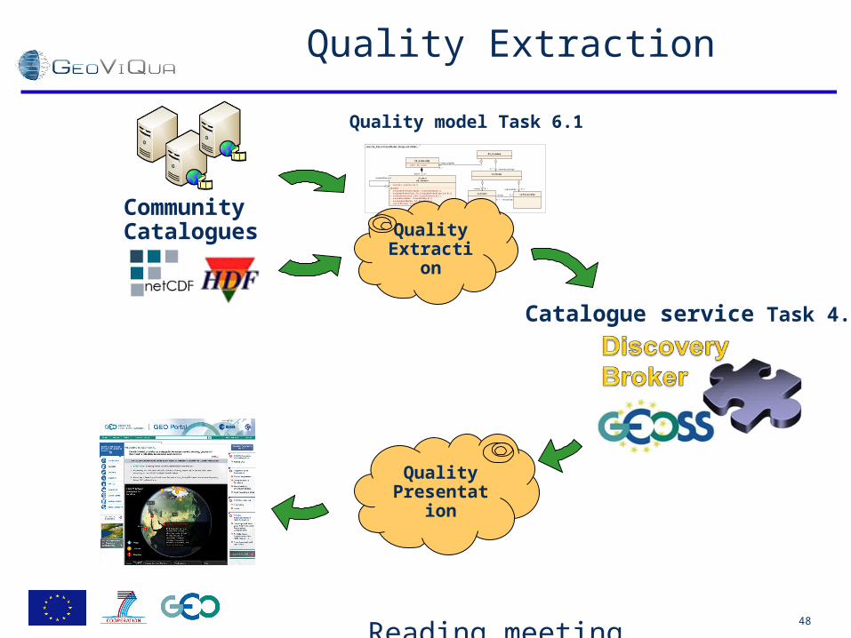
Quality model Task 6.1
Quality Extraction
Quality Presentatio
n
Catalogue service Task 4.1
CommunityCatalogues

Reading meeting. December 12-14th,
2011
39
Adapt data to EuroGEOSS broker model
• Tool to transform quality data to a common format (Kevin's quality model based on ISO 19115-1 and 19157)– Tool to transform from other formats
• NetCDF
• HDF
• …
– Tool to transform form other standards used in capacity catalogues• (needed CNR contribution here)
class DQ_Element classification, lineage and citation
DQ_DataQuality
+ scope :DQ_Scope
«Abstract»DQ_Element
+ dateTime :DateTime [0..*]
«moved»+ evaluationMethodDescription :CharacterString [0..1]+ evaluationMethodType :DQ_EvaluationMethodTypeCode [0..1]+ evaluationProcedure :DQM_SourceReference [0..1]+ measureDescription :CharacterString [0..1]+ measureIdentification :MD_Identifier [0..1]+ nameOfMeasure :CharacterString [0..*]
MD_Metadata
LI_Source LI_ProcessStep
LI_Lineage
+resourceLineage0..*
+processStep 0..*+source 0..*
+source
0..* +sourceStep
0..*
+dataQualityInfo
0..*
+derivedElement
0..*report
Quality model Task 6.1
Quality Extraction
Catalogue service Task 4.1

Reading meeting. December 12-14th,
2011
40
Example of NetCDF ->ISO 19115
• https://geo-ide.noaa.gov/wiki/index.php?title=NetCDF_Attribute_Convention_for_Dataset_Discovery

Reading meeting. December 12-14th,
2011
41
To the EuroGEOSS broker
• If there are no quality parameters, a tool to extract data quality from provenance data (in theory)
– In order this to be possible, we need a link between the resource and its sources. This is possible if there is a link to the source metadata document.
– But links are poor populated and they can not function as real links• 59FR13375• NF-05-05 GSF Multibeam Data• J:\Albuq_orig_meta\PAIS\pais_valley_pipl.xml• Server=204.47.240.122; Service=esri_sde; User=geo_pol; Version=SDE.DEFAULT• drto_DOQQ.sid, Projection: NAD_ 83_UTM_Zone 16N, Meters.• Stark County, Ohio GIS Parcel Data (http://downloads.ddti.net/starkoh/)• BLM Digital GCDB Flat Files (http://www.blm.gov/ca/st/en/prog/cadastral/gcdbpage.html)
– They are not useful to link to source data in the GCI or in other catalogues.– What are we going to do?
class DQ_Element classification, lineage and citation
DQ_DataQuality
+ scope :DQ_Scope
«Abstract»DQ_Element
+ dateTime :DateTime [0..*]
«moved»+ evaluationMethodDescription :CharacterString [0..1]+ evaluationMethodType :DQ_EvaluationMethodTypeCode [0..1]+ evaluationProcedure :DQM_SourceReference [0..1]+ measureDescription :CharacterString [0..1]+ measureIdentification :MD_Identifier [0..1]+ nameOfMeasure :CharacterString [0..*]
MD_Metadata
LI_Source LI_ProcessStep
LI_Lineage
+resourceLineage0..*
+processStep 0..*+source 0..*
+source
0..* +sourceStep
0..*
+dataQualityInfo
0..*
+derivedElement
0..*report
Quality model Task 6.1
Quality Extraction
Catalogue service Task 4.1

Reading meeting. December 12-14th,
2011
42
To the GEOPortal
• A XSL transformation that allows better visibility of the quality indicators, lineage/provenance etc.
• Ted portal and the metadata punctuation adapted for DataQuality
Quality Presentatio
n
Catalogue service Task 4.1

Reading meeting. December 12-14th,
2011
43
NOAA metadata records
http://www.ngdc.noaa.gov/metadata/published/NOAA/NESDIS/CLASS/iso/

Reading meeting. December 12-14th,
2011
44
Rubric XSL
• Ted Habermann

®
QUAlity aware VIsualisation for the Global Earth QUAlity aware VIsualisation for the Global Earth Observation system of systemsObservation system of systems
Reading meeting. December 12-14th, 2011
Wednesday

Reading meeting. December 12-14th,
2011
46
Day 14 Morning - Henley Business School, Room 102
• 09:00_09:20 Many Short report on the split sessions focussing in coordination aspects
• 09:20_09:45 Eva Sevillano Current status of the GEOSS quality Metadata
• 09:45_10:55 Thorsten Reitz Requirements communicate conclusions and organize some corrections Cluster adaptors,
• 10:55_11:15 Coffee break
• 11:15_12:00 Simon Discard requirements that are interesting but we will not be able to address (pragmatic choices and decisions)
• 12:00_12:30 Joan Masó Review strategy for next deliverables and final comments
• 12:30_14:00 Lunch

®
QUAlity aware VIsualisation for the Global Earth QUAlity aware VIsualisation for the Global Earth Observation system of systemsObservation system of systems
Reading meeting. December 12-14th, 2011
Reports on split sessions
Focus on actions
Reading meeting. December 12-14th,
2011
48
Quality Extraction
class DQ_Element classification, lineage and citation
DQ_DataQuality
+ scope :DQ_Scope
«Abstract»DQ_Element
+ dateTime :DateTime [0..*]
«moved»+ evaluationMethodDescription :CharacterString [0..1]+ evaluationMethodType :DQ_EvaluationMethodTypeCode [0..1]+ evaluationProcedure :DQM_SourceReference [0..1]+ measureDescription :CharacterString [0..1]+ measureIdentification :MD_Identifier [0..1]+ nameOfMeasure :CharacterString [0..*]
MD_Metadata
LI_Source LI_ProcessStep
LI_Lineage
+resourceLineage0..*
+processStep 0..*+source 0..*
+source
0..* +sourceStep
0..*
+dataQualityInfo
0..*
+derivedElement
0..*report
Quality model Task 6.1
Quality Extraction
Quality Presentatio
n
Catalogue service Task 4.1
CommunityCatalogues

Reading meeting. December 12-14th,
2011
49
Actions
• We will study the way netCDF and HDF quality metadata can be imported
• We will consider some capacity catalogues metadata as candidates to import
• XSL will be provided to transform metadata schemas into readable forms to illustrate how to present quality metadata to the user
• Close collaboration with WP4 (CNR) and data quality model (WP6.1).

®
QUAlity aware VIsualisation for the Global Earth QUAlity aware VIsualisation for the Global Earth Observation system of systemsObservation system of systems
Reading meeting. December 12-14th, 2011
Review strategy for next deliverables and final
comments

Reading meeting. December 12-14th,
2011
51
Next deliverables
• D3.1 Metadata extraction quality component – Month 12 January 2012 (CREAF)
• D7.2 Report on current GCI and identification of issues in integration with GEOSS – Month 12 January 2012 (UAB)
• D2.1 User requirements document – Month 13 February 2012 (FRAUN)
• D2.2 Technical requirements document – Month 14 March 2012 (FRAUN)
• D6.1 Data quality encoding as a best practice paper – Month 15 April 2012 (ASTON)– Connected to BPW tutorials.

Reading meeting. December 12-14th,
2011
52
Actions
• WP 3.1 Quality extraction tools should be generated soon.– Deliverable D3.1 should be produced
• WP 7.1 Current status of the clearinghouse finish.– Deliverable D7.2 should be produced
• WP 6.1 Data Model should be finished soon – philosophical paper should be produced
– Deliverable D6.1 should be produced
• WP 2.1 WP 2.2 requirements process first phase should end– Deliverables D2.1 and D2.2 should be produced
• Scenarios storyboard should mature and components shall be clearly identified– Presented in the next PTB telecon
• I would like to nominate a volunteer to look on the Liferay 5.1.2 platform and Liferay database
– Results presented in the next PTB telecon
– Name:

Reading meeting. December 12-14th,
2011
53
Sprint to project evaluation
• We will have a project evaluation on Month 18 (July 2011)
• We are more or less on track but we need to move forward.
• We have– Requirements, scenarios, components, data models
• It is time to start developing components for elicitation WP3, search WP4 and visualization WP5.
• They don't next to be finalized but ideally some prototypes could be used to illustrate the feasibility of our ideas in some controlled situations
• Plans to achieve this objective would be presented by the 3 WP leaders in the next PTB telecon (January)– Monthly telecons will follow

Reading meeting. December 12-14th,
2011
54
Logistics
• Please, please upload your presentations to the twiki page– http://twiki.geoviqua.com/twiki/bin/view/GeoViQuaIntranet/
PTBMeeting03– Done: SC GEOPortal, CREAF introduction + split session + GCI
metadata study, WP4, 52N materials
• Next Face2face meeting will be in ~July– The place will be announced soon
• Thanks to University of Reading (Jon + Kevin) to organize this event.
®
QUAlity aware VIsualisation for the Global Earth QUAlity aware VIsualisation for the Global Earth Observation system of systemsObservation system of systems
Reading meeting. December 12-14th, 2011
Summary

®
QUAlity aware VIsualisation for the Global Earth QUAlity aware VIsualisation for the Global Earth Observation system of systemsObservation system of systems
Reading meeting. December 12-14th, 2011
Thank you!
The meeting is adjourneduntil next face to face meeting