Embed Size (px)
Citation preview
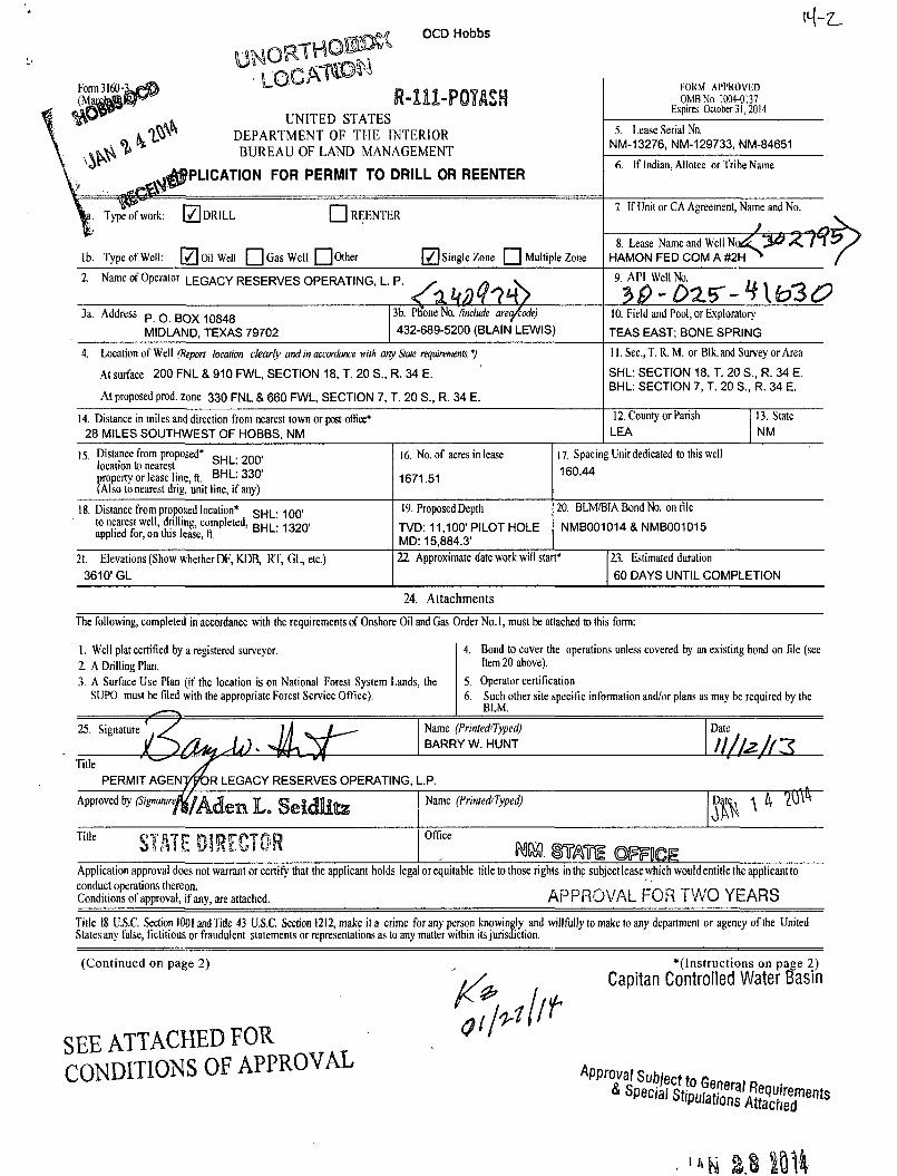
OCD Hobbs
Form3160 (Mi R-111-P0TAS8
UNITED STATES DEPARTMENT OF THE INTERIOR BUREAU OF LAND MANAGEMENT
PLICATION FOR PERMIT TO DRILL OR REENTER
FORM APPROVED OMB No. 1004-0137
Expires October 31,2014
5. Lease Serial No. NM-13276, NM-129733, NM-84651
6. If Indian, Allotee or Tribe Name
. Type of work: \ 7 \ DRILL • REENTER
lb. Type of Well: [ 7 ] Oil Well • Gas Well Qother [ / ] Single Zone Q Multiple Zone
7 If Unit or CA Agreement, Name and No.
8. Lease Name and Well HAMON FED COM A #2H * 2 H ^ /
2. Name of Operator LEGACY RESERVES OPERATING, L. P.
^ 4 9. API Well No. , ,
3a. Address p 0 B Q X 1 0 8 4 8
MIDLAND, TEXAS 79702
3b. Phone No. (include arecJcodej
432-689-5200 (BLAIN LEWIS)
10. Field and Pool, or Exploratory
TEAS EAST; BONE SPRING
4. Location of Well (Report location clearly and in accordance wilh any Stale requirements. *)
At surface 200 FNL & 910 FWL, SECTION 18, T. 20 S., R. 34 E.
At proposed prod, zone 330 FNL & 660 FWL, SECTION 7, T. 20 S„ R. 34 E.
11. Sec, T. R. M. or Blk.and Survey or Area
SHL: SECTION 18, T. 20 S., R. 34 E. BHL: SECTION 7, T. 20 S., R. 34 E.
14. Distance in miles and direction from nearest town or post office* 28 MILES SOUTHWEST OF HOBBS, NM
12. County or Parish LEA
13. State NM
15 Distance from proposed* „ H I • onrv location to nearest property or lease line, ft. B H L : 330 (Also to nearest drig. unit line, if any)
16. No. of acres in lease
1671.51
17. Spacing Unit dedicated to this well
160.44
18. Distance from proposed location* g^[_- 100' to nearest well, drilling, completed, D U . \ 1 0 0 r v applied for, on this lease, ft. H H L -
19. Proposed Depth
TVD: 11,100'PILOT HOLE MD: 15,884.3'
20. BLM/BIA Bond No. on file
NMB001014 & NMB001015
21. Elevations (Show whether DF, KDB, RT, GL, etc.)
3610' GL
22 Approximate date work will start* 23. Estimated duration
60 DAYS UNTIL COMPLETION
24. Attachments The following, completed in accordance with the requirements of Onshore Oil and Gas Order No. 1, must be attached to this form:
1. Well plat certified by a registered surveyor. 2 A Drilling Plan. 3. A Surface Use Plan (if the location is on National Forest System Lands, the
SUPO must be filed with the appropriate Forest Service Office).
4. Bond to cover the operations unless covered by an existing bond on file (see Item 20 above).
5. Operator certification 6. Such other site specific information and/or plans as mav be required by the
BLM.
Name (Printed/Typed) BARRY W. HUNT
Date
Title ' ' " / f ' " ' PERMIT AGENJ^OR LEGACY RESERVES OPERATING, L.P.
Approved by ^ ^ A d e m L ( > Name (Printed/Typed)
Title STATE DIRECTOR Office
Mi. SOTi ©FFSeiS Application approval does not warrant or certify that the applicant holds legal or equitable title to those rights in the subjectlease which would entitle the applicantto
conduct operations thereon. . _, „ _ r , . , . , L-r\ - i -r\mr>L \ / r - * n <-. Conditions of approval, if any, are attached. A P P R O V A L r O H I W U Y L A R b
Title 18 U.S.C. Section 1001 and Title 43 US.C. Section 1212, make it a crime for any person knowingly and willfully to make to any department or agency of the United States any false, fictitious or fraudulent statements or representations as to any matter within its jurisdiction.
(Continued on page 2)
SEE ATTACHED FOR CONDITIONS OF APPROVAL
"(Instructions on page 2)
Capitan Controlled Water Basin
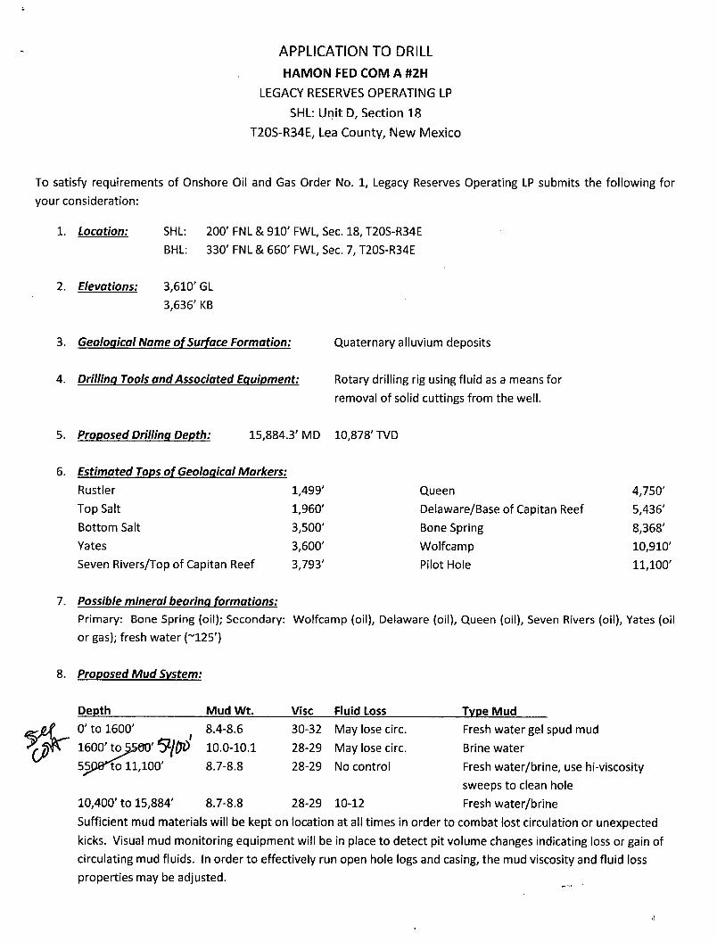
APPLICATION TO DRILL HAMON FED COM A #2H
LEGACY RESERVES OPERATING LP
SHL: Unit D, Section 18
T20S-R34E, Lea County, New Mexico
To satisfy requirements of Onshore Oil and Gas Order No. 1, Legacy Reserves Operating LP submits the following for
your consideration:
1. Location: SHL: 200'FNL & 910'FWL, Sec. 18, T20S-R34E
BHL: 330' FNL & 660' FWL, Sec. 7, T20S-R34E
2. Elevations: 3,610' GL
3,636' KB
3. Geological Name of Surface Formation: Quaternary alluvium deposits
4. Drilling Tools and Associated Equipment: Rotary drilling rig using fluid as a means for
removal of solid cuttings from the well.
5. Proposed Drilling Depth: 15,884.3'MD 10,878'TVD
6. Estimated Tops of Geological Markers:
Rustler 1,499'
Top Salt 1,960'
Bottom Salt 3,500'
Yates 3,600'
Seven Rivers/Top of Capitan Reef 3,793'
Queen 4,750'
Delaware/Base of Capitan Reef 5,436'
Bone Spring 8,368'
Wolfcamp 10,910'
Pilot Hole 11,100'
7. Possible mineral bearing formations:
Primary: Bone Spring (oil); Secondary: Wolfcamp (oil), Delaware (oil), Queen (oil), Seven Rivers (oil), Yates (oil
or gas); fresh water (~125')
8. Proposed Mud System:
Depth Mud Wt. Vise Fluid Loss Type Mud
0' to 1600' ( 8.4-8.6
1600' T.O5JS0O' S-flP 10.0-10.1
55P8*1oll,100' 8.7-8.8
30-32 May lose circ. Fresh water gel spud mud
28-29 May lose circ. Brine water
28-29 No control Fresh water/brine, use hi-viscosity
sweeps to clean hole
8.7-8.8 28-29 10-12 Freshwater/brine
Sufficient mud materials will be kept on location at all times in order to combat lost circulation or unexpected
kicks. Visual mud monitoring equipment will be in place to detect pit volume changes indicating loss or gain of
circulating mud fluids. In order to effectively run open hole logs and casing, the mud viscosity and fluid loss
properties may be adjusted.
10,400' to 15,884'
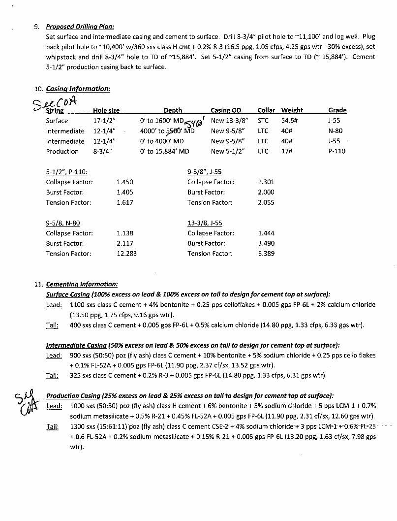
9. Proposed Drilling Plan:
Set surface and intermediate casing and cement to surface. Drill 8-3/4" pilot hole to ~11,100' and log well. Plug
back pilot hole to ~10,400' w/360 sxs class H cmt + 0.2% R-3 (16.5 ppg, 1.05 cfps, 4.25 gps wtr - 30% excess), set
whipstock and drill 8-3/4" hole to TD of ~15,884'. Set 5-1/2" casing from surface to TD (~ 15,884'). Cement
5-1/2" production casing back to surface.
10. Casing Information:
^ String Hole size Depth Casing OD Collar Weight Grade
Surface 17-1/2" 0' to 1 6 0 0 ' M D ^ y ^ '
4000' to 5>rJ0' MD
New 13-3/8" STC 54.5# J-55
Intermediate 12-1/4"
0' to 1 6 0 0 ' M D ^ y ^ '
4000' to 5>rJ0' MD New 9-5/8" LTC 40# N-80
Intermediate 12-1/4" 0' to 4000' MD New 9-5/8" LTC 40# J-55
Production 8-3/4" 0' to 15,884' MD New 5-1/2" LTC 17# P-110
5-1/2", P-110:
Collapse Factor: 1.450
Burst Factor: 1.405
Tension Factor: 1.617
9-5/8. N-80
Collapse Factor: 1.138
Burst Factor: 2.117
Tension Factor: 12.283
9-5/8". J-55
Collapse Factor: 1.301
Burst Factor: 2.000
Tension Factor: 2.055
13-3/8. J-55
Collapse Factor: 1.444
Burst Factor: 3.490
Tension Factor: 5.389
11. Cementing Information:
Surface Casing (100% excess on lead & 100% excess on tail to design for cement top at surface):
Lead: 1100 sxs class C cement + 4% bentonite + 0.25 pps celloflakes + 0.005 gps FP-6L + 2% calcium chloride
(13.50 ppg, 1.75 cfps, 9.16 gps wtr).
Tail: 400 sxs class C cement + 0.005 gps FP-6L + 0.5% calcium chloride (14.80 ppg, 1.33 cfps, 6.33 gps wtr).
Intermediate Casing (50% excess on lead & 50% excess on tail to design for cement top at surface):
Lead: 900 sxs (50:50) poz (fly ash) class C cement + 10% bentonite + 5% sodium chloride + 0.25 pps cello flakes
+ 0.1% FL-52A + 0.005 gps FP-6L (11.90 ppg, 2.37 cf/sx, 13.52 gps wtr).
Tail: 325 sxs class C cement + 0.2% R-3 + 0.005 gps FP-6L (14.80 ppg, 1.33 cfps, 6.31 gps wtr).
Production Casing (25% excess on lead & 25% excess on tail to design for cement top at surface):
Lead: 1000 sxs (50:50) poz (fly ash) class H cement + 6% bentonite + 5% sodium chloride + 5 pps LCM-1 + 0.7%
sodium metasilicate + 0.5% R-21 + 0.45% FL-52A + 0.005 gps FP-6L (11.90 ppg, 2.31 cf/sx, 12.60 gps wtr).
Tail: 1300 sxs (15:61:ll) poz (fly ash) class C cemenrCSE-2+"4%rsodium-chloride "+3 pps LCM-1+-0.6% FL=25
+ 0.6 FL-52A + 0.2% sodium metasilicate + 0.15% R-21 + 0.005 gps FP-6L (13.20 ppg, 1.63 cf/sx, 7.98 gps
wtr).
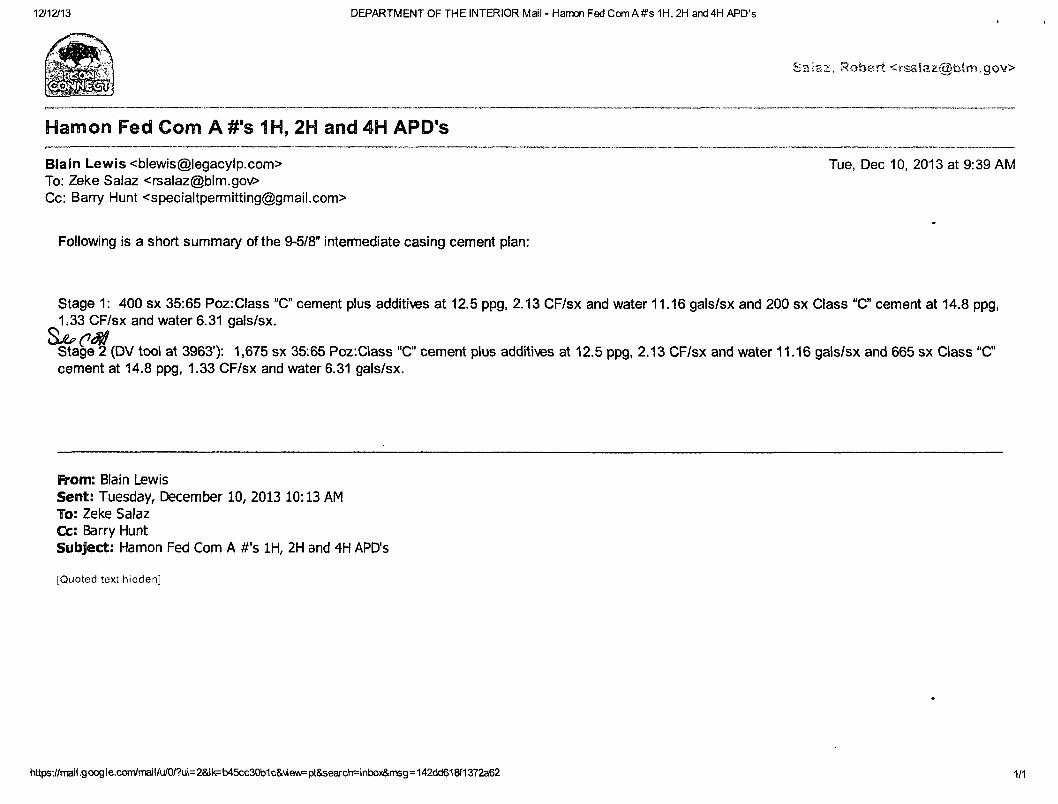
12/12/13 DEPARTMENT OF THE INTERIOR Mail - Hamon Fed Com A#s 1H, 2H and 4H APD's
Saiaz, Robert <«-$aiaz@blm,gov>
Hamon Fed Com A #'s 1H, 2H and 4H APD's
Blain Lewis <[email protected]> Tue, Dec 10, 2013 at 9:39 AM To: Zeke Salaz <[email protected]> Cc: Barry Hunt <[email protected]>
Following is a short summary of the 9-5/8" intermediate casing cement plan:
Stage 1: 400 sx 35:65 Poz:Class "C" cement plus additives at 12.5 ppg, 2.13 CF/sx and water 11.16 gals/sx and 200 sx Class "C cement at 14.8 ppg, 1.33 CF/sx and water 6.31 gals/sx.
Stage 2 (DV tool at 3963'): 1,675 sx 35:65 Poz.Class "C" cement plus additives at 12.5 ppg, 2.13 CF/sx and water 11.16 gals/sx and 665 sx Class "C" cement at 14.8 ppg, 1.33 CF/sx and water 6.31 gals/sx.
From: Blain Lewis Sent: Tuesday, December 10, 2013 10:13 AM To: Zeke Salaz Cc: Barry Hunt Subject: Hamon Fed Com A #'s 1H, 2H and 4H APD's
[Quoted text hidden]
httf«-.//rrBil.google.conVrrailM^ 1/1
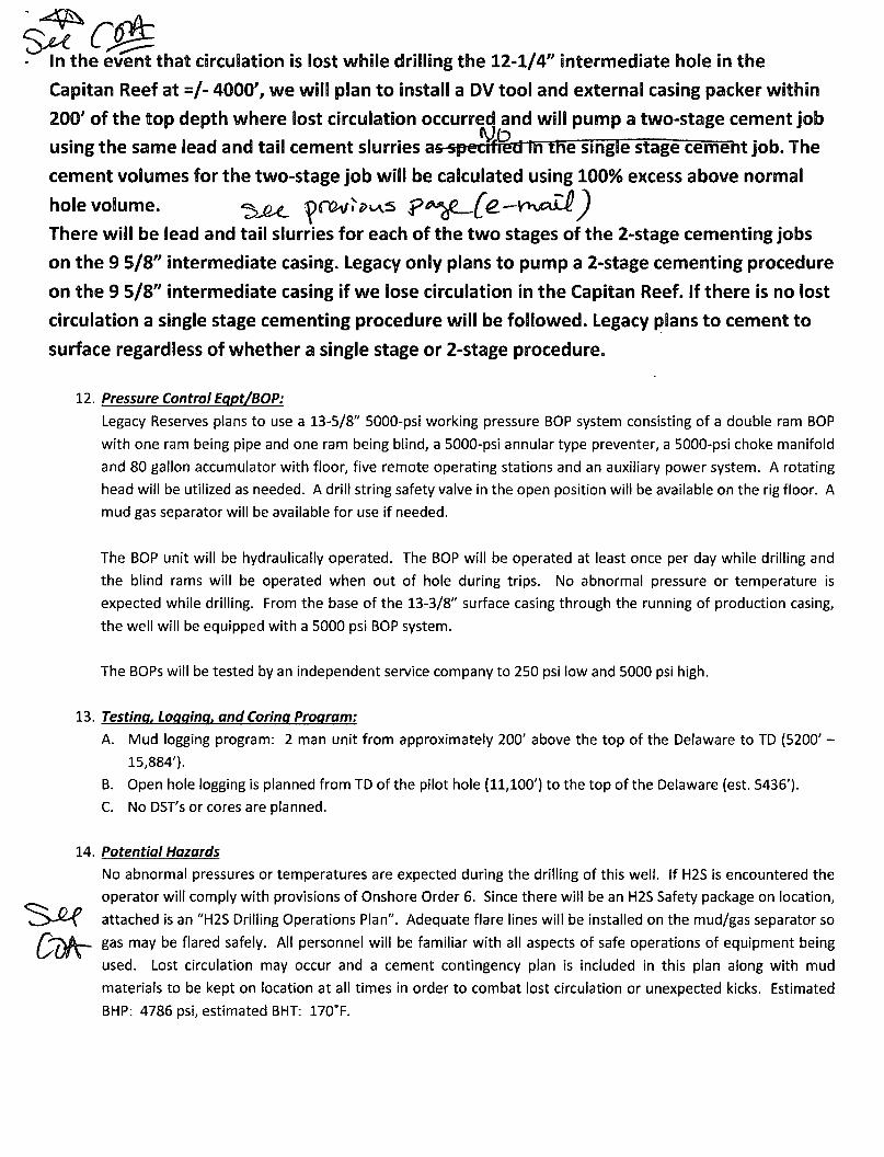
In the event that circulation is lost while drilling the 12-1/4" intermediate hole in the
Capitan Reef at =/- 4000', we will plan to install a DV tool and external casing packer within
200' of the top depth where lost circulation occurred and will pump a two-stage cement job
using the same lead and tail cement slurries as-si»etrfred in the single stage cement job. The
cement volumes for the two-stage job will be calculated using 100% excess above normal
hole volume. "^>JU, ^n2vl>t\s p*^fL~[£— Y>^Zi^
There will be lead and tail slurries for each of the two stages of the 2-stage cementing jobs
on the 9 5/8" intermediate casing. Legacy only plans to pump a 2-stage cementing procedure
on the 9 5/8" intermediate casing if we lose circulation in the Capitan Reef, if there is no lost
circulation a single stage cementing procedure will be followed. Legacy plans to cement to
surface regardless of whether a single stage or 2-stage procedure.
12. Pressure Control Egpt/BOP:
Legacy Reserves plans to use a 13-5/8" 5000-psi working pressure BOP system consisting of a double ram BOP
with one ram being pipe and one ram being blind, a 5000-psi annular type preventer, a 5000-psi choke manifold
and 80 gallon accumulator with floor, five remote operating stations and an auxiliary power system. A rotating
head will be utilized as needed. A drill string safety valve in the open position will be available on the rig floor. A
mud gas separator will be available for use if needed.
The BOP unit will be hydraulically operated. The BOP will be operated at least once per day while drilling and
the blind rams will be operated when out of hole during trips. No abnormal pressure or temperature is
expected while drilling. From the base of the 13-3/8" surface casing through the running of production casing,
the well will be equipped with a 5000 psi BOP system.
The BOPs will be tested by an independent service company to 250 psi low and 5000 psi high.
13. Testing, Logging, and Coring Program:
A. Mud logging program: 2 man unit from approximately 200' above the top of the Delaware to TD (5200' -
15,884').
B. Open hole logging is planned from TD of the pilot hole (11,100') to the top of the Delaware (est. 5436').
C. No DST's or cores are planned.
14. Potential Hazards
No abnormal pressures or temperatures are expected during the drilling of this well, if H2S is encountered the
operator will comply with provisions of Onshore Order 6. Since there will be an H2S Safety package on location,
attached is an "H2S Drilling Operations Plan". Adequate flare lines will be installed on the mud/gas separator so
6 a s may be flared safely. All personnel will be familiar with all aspects of safe operations of equipment being
used. Lost circulation may occur and a cement contingency plan is included in this plan along with mud
materials to be kept on location at all times in order to combat lost circulation or unexpected kicks. Estimated
BHP: 4786 psi, estimated BHT: 170°F.

15. Road and Location
Road and location construction will begin after BLM approval of the APD. The anticipated spud date is May 25,
2014. Drilling is expected to take 30-35 days and an additional 10 days for the completion.
16. Additional Requirements of Project:
Completion: The targeted Bone Spring pay zone will be perforated and stimulated in multiple stages using
acid and hydraulic fracturing treatments. Fresh water used in the drilling and completion of this
well will be transferred from off-site via temporary flowlines and stored in frac tanks on the
location.
Vertically/directionally drilled; not perf d
O First Perf; Upper Perf Point
1 | Hamon Fed Com A 2H
40.19 Ac
(AKA: Lnif 'D")
40.14 Ac
(AKA: Lnif 'E")
40.08 Ac
(AKA: L nit "L")
40.03 Ac O
(AKA: Unit "M")
O
(AKA: L nit "C")
(AKA: Lnif 'F")
(AKA: Unit"K")
\
o (AKA: Uflit "N")
Horizontally drilled; perf'd
O Last Perf; Lower Perf Point
|" | Hamon Fed Com A1H
"••••3-1
40 Ac
(AKA: Unit "D") (AKA: Unit "C")
2
40.01 Ac
Project: Hamon Site- Hamon Fed Com A 2H Well: Hamon Fed Com A 2H
Wellbore: 130430 Hamon Fed Com 2H Design: 130430 Hamon Fed Com 2H \
M Azimuths to Grid North ^ True North: -0.39*
i Magnetic North: 7.00°
/ Magnetic Reld / Strength: 48680.2snT rN Dip Angle: 60.49" - f Date: 01/05/2013 y Model: IGRF200510
5400
5100— 5100— 5100—
4500
- •
4200
3900
3600
3300
ID
^ 3000 O
52-
i f 2700 •c o z
• JZ 2400
o W
2100
1800
1500
1200
900
600
300 300 t n n
i l l
-2<
I I I I
00 -u
I I I I
00 -15
I I I I
00 -15
i r I i
00 -s
1 1 1 1
00 -6
Wes
i i i i
30 -31
t(-)/East(
i 1 1 1 I 1 1 1 1 0 0 3C +) (600 usft/in)
n i l
0 6C
1 1 1 1
0 9C r i i i
0 12
l" I 1 I I
00
M
I I I I
M C k J O
Project: Hamon Site: Hamon Fed Com A 2H Well: Hamon Fed Com A 2H
Wellbore: 130430 Hamon Fed Com 2H Design: 130430 Hamon Fed Com 2H
G T i k M Azimuths to Grid North
/ A
True North: -0.39° / A
Magnetic North: 7.00°
\ / Magnetic Field
\ / Strength: 48680.2snT
/ \ Dip Angle: 60.49'
+-- T Date: 01/0572013 Model: IGRF200510
750-
1500-
2250-
3000-
3750-
4500-
5250-
£ in u 6000-o o *— £ 6750-a. OJ Q
.13 3/8'
9 5/8" - J
-100 0 100 200
Vertical Section at 356.82° (200 usft/in>
r > 3
7500-
8250-
9000-
9750-BSPG3
10500- - TOP OF BSPG 3 PAY
11250-
5 1/2"
- 1
Hamon Fed ComA#2H
12000-
12750-
13500-
i I I I
750 1500 2250 3000 3750 4500
Vertical Section at 356.82° (1500 usft/in)
i i i i
6750 7500 -2250 -1500 -750 5250 6000
Legacy Reserves LP Hamon Hamon Fed Com A 2H 130430 Hamon Fed Com 2H
Plan: 130430 Hamon Fed A Com 2H
MOJO Standard Survey
M O J Q
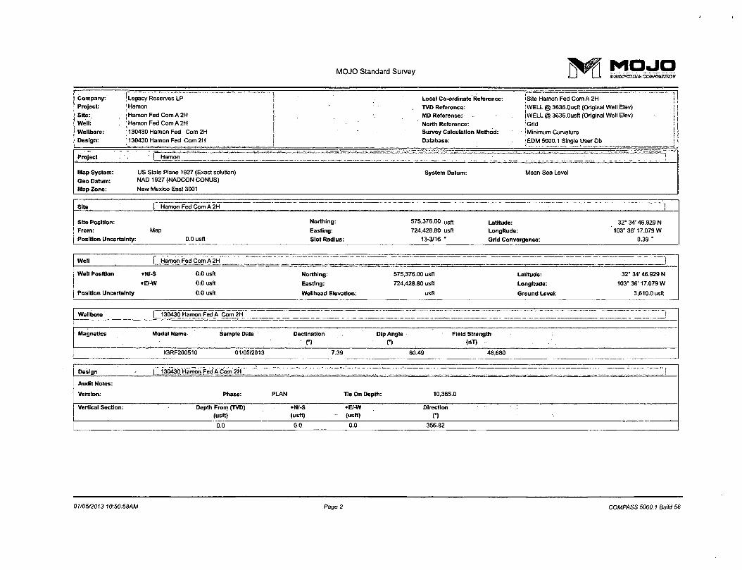
MOJO Standard Survey ] ^ ^ ^
Company:
Project:
Site:
Well:
Wellbore:
Design:
Legacy Reserves LP
Hamon
Hamon Fed Com A 2H
Hamon Fed Com A 2H
130430 Hamon Fed Com2H
130430 Hamon Fed Com 2H
" "
• -
Local Co-ordinate Reference:
TVD Reference:
MD Reference: •
North Reference: Survey Calculation Method:
Database:
I Site Hamon Fed Com A 2H
I WELL @ 3636.0usft (Original Well Elev)
WELL @ 3636.0usft (Original Well Elev)
iGrid
! Minimum Curvature
[EDM 5000.1 Single User Db , l Project ' j Hamon J
Map System:
Geo Datum:
Map Zone:
US State Plane 1927 (Exact solution)
NAD 1927 (NADCON CONUS)
New Mexico East 3001
System Datum: Mean Sea Level
Site Site f Hamon Fed Com A 2H i
Site Position: Northing: 575,376.00 u s f l Latitude: 32° 34' 46.929 N From: Map Easting: 724,428.80 usft Longitude: 103° 36'17.079 W
Position Uncertainty: 0.0 usft Slot Radius: 13-3/16 • Grid Convergence: 0.39 '
Well | Hamon Fed Com A 2H . . . . . . . . . , ^ . '_ i Well Position +N/-S 0.0 usft Northing: 575,376.00 usft Latitude: 32" 34' 46.929 N
•E/-W 0.0 usft Easting: 724,428.80 usft Longitude: 103" 36'17.079 W
Position Uncertainty 0.0 usft Wellhead Elevation: usft Ground Level: 3,610.0 usft
Wellbore | 130430 Hamon Fed A Com 2H _)
Magnetics Model Name Sample Date Declination Dip Angle Field Strength
o C) (nT)
IGRF200510 01/05/2013 7.39 60.49 48,680
Design (_130430 Hamon Fed A Com 2H
Audit Notes:
Version: Phase: PLAN Tie On Depth: 10,365.0
Vertical Section: Depth From (TVD) (usft)
+N/-S (usft)
+E/-W (usft)
Direction :
n 0.0 0.0 0.0 356.82
01/05/2013 10:50:58AM Page 2 COMPASS 5000.1 Build 56
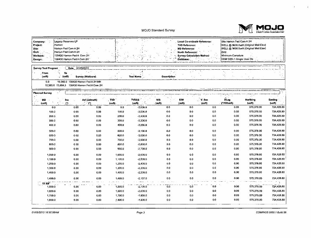
MOJO Standard Survey M O J O
Company: Legacy Reserves LP - , Local Co-ordinate Reference: Site Hamon Fed Com A 2H
Project: Hamon TVD Reference: WELL @ 3636.0usft (Original Well Elev)
Site: Hamon Fed Com A 2H . MD Reference: WELL @ 3636.0usft (Original Well Elev)
-Well: Hamon Fed Com A 2H « • North Reference: ' Grid
Wellbore: 130430 Hamon Fed A Com 2H s~ •. • >_: • ,* % Survey Calculation Method: Minimum Curvature
.'Design:, 130430 Hamon Fed A Com 2H , •> •-. * ' ' Database: '"."„".'•'• ''• '• EDM 5000.1 Single User Db
Survey Tool Program [ Date 01/05/2013 t ^ , , ' i-
' .From To '• _
(usft) .„ (usft) Survey (Wellbore) Tool Name Description " v ; ' .
0.0 10,365.0 130430 Hamon Fed A 2HMH
10,365.0 15,884.3 130430 Hamon Fed A Com 2H
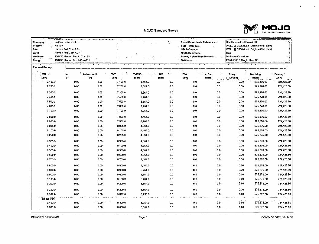
Planned Survey
MD (usft)
t " =,..^.^.. i,-^ ~ — ~ ===== ——^>
Easting (usft)
Planned Survey
MD (usft)
' Inc
n Azi (azimuth)
n . TVD (usft)
TVDSS (usft) ; r ,
N/S . (usft)
E/W (usft)
V. Sec (usft)
DLeg C/IOOusft)
Northing (usft).
Easting (usft)
0.0 0.00 0.00 0.0 -3,636.0 0.0 0.0 0.0 0.00 575,376.00 724,428.80
100.0 0.00 0.00 100.0 -3,536.0 0.0 0.0 0.0 0.00 575,376.00 724,428.80
200.0 0.00 0.00 200.0 -3,436.0 0.0 0.0 0.0 0.00 575,376.00 724,428.80
300.0 0.00 0.00 300.0 -3,336.0 0.0 0.0 0.0 0.00 575,376.00 724,428.80
400.0 0.00 0.00 400.0 -3,236.0 0.0 0.0 0.0 0.00 575,376.00 724,428.80
500.0 0.00 0.00 500.0 -3,136.0 0.0 0.0 0.0 0.00 575,376.00 724,428.80
600.0 0.00 0.00 600.0 -3,036.0 0.0 0.0 0.0 0.00 575,376.00 724,428.80
700.0 0.00 0.00 700.0 -2,936.0 0.0 0.0 0.0 0.00 575,376.00 724,428.80
800.0 0.00 0.00 800.0 -2,836.0 0.0 0.0 0.0 0.00 575,376.00 724,428.80
900.0 0.00 0.00 900.0 -2,736.0 0.0 0.0 0.0 0.00 575,376.00 724,428.80
1,000.0 0.00 0.00 1,000.0 -2,636.0 0.0 0.0 0.0 0.00 575,376.00 724,428.80
1,100.0 0.00 0.00 1,100.0 -2,536.0 0.0 0.0 0.0 0.00 575,376.00 724,428.80
1,200.0 0.00 0.00 1,200.0 -2,436.0 0.0 0.0 0.0 0.00 575,376.00 724,428.80
1,300.0 0.00 0.00 1,300.0 -2,336.0 0.0 0.0 0.0 0.00 575,376.00 724,428.80
1,400.0 0.00 0.00 1,400.0 -2,236.0 0.0 0.0 0.0 0.00 575,376.00 724,428.80
1,499.0 0.00 0.00 1,499.0 -2,137.0 0.0 0.0 0.0 0.00 575,376.00 724,428.80
; " 13 3/8" 2_ . _ - - - . .. . . - — ": 1.500.0 ~ 0.00^ obo "1,500.6 0.0 o.o 0.0 0.00 ~ 575,376.00 724,428.80
1,600.0 0.00 0.00 1,600.0 -2,036.0 0.0 0.0 0.0 0.00 575,376.00 724,428.80
1,700.0 0.00 0.00 1,700.0 -1,936.0 0.0 0.0 0.0 0.00 575,376.00 724,428.80
1,800.0 0.00 0.00 (1,800.0 -1,836.0 0.0 0.0 0.0 0.00 575,376.00 724,428.80
01/05/2013 10:50:58AM Page 3 COMPASS 5000.1 Build 56
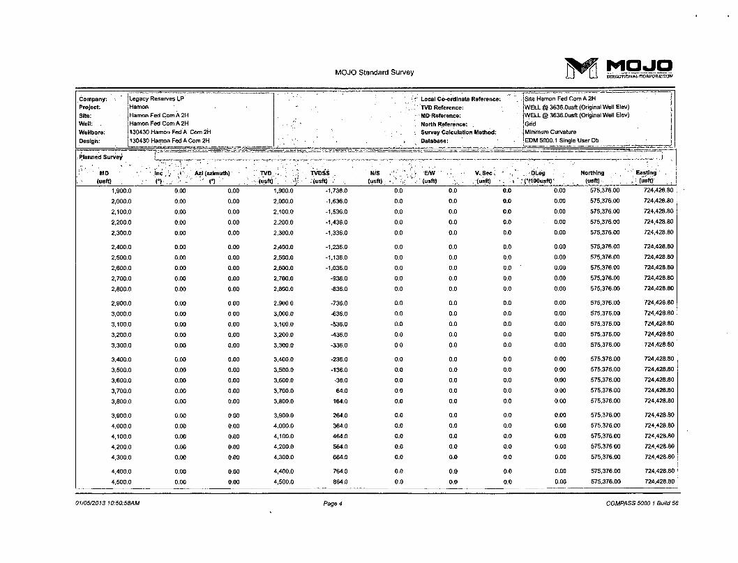
MOJO Standard Survey M O J O
Company:
Project:
Site:
Well: .
Wellbore:
Design:
Legacy Reserves LP
Hamon
Hamon Fed Com A 2H
Hamon Fed Com A 2H
130430 Hamon Fed A Com 2H
130430 Hamon Fed A Com 2H
Local Co-ordinate Reference:
TVD Reference:
-MD Reference:
North Reference:
Survey Calculation Method:
Database:
Site Hamon Fed Com A 2H
WELL @ 3636.0usft (Original Well Elev)
WELL @ 3636.0usft (Original Well Elev)
Grid
Minimum Curvature
EDM 5000.1 Single User Db
Planned Survey
' MO ; . (usft)
r~ ^ •- - ! — ~!
. 1 Planned Survey
' MO ; . (usft)
' I n c ,
C) . Azi (azimuth)
(") , . : TVD , • (usft) :"'
TVDSS . (usft) ;
N/S (USft) ;
':.''] « E/W . (usft)
V.Sec (usft)
OLeg >(°/ioousft)'
Northing ;
(usft)
Easting
(usft)
1,900.0 0.00 0.00 1,900.0 -1,736.0 0.0 0.0 0.0 0.00 575,376.00 724,428.80
2,000.0 0.00 0.00 2,000.0 -1,636.0 0.0 0.0 0.0 0.00 575,376.00 724,428.80
2,100.0 0.00 0.00 2,100.0 -1,536.0 0.0 0.0 0.0 0.00 575,376.00 724,428.80
2,200.0 0.00 0.00 2,200.0 -1,436.0 0.0 0.0 0.0 0.00 575,376.00 724,428.80
2,300.0 0.00 0.00 2,300.0 -1,336.0 0.0 0.0 0.0 0.00 575,376.00 724,428.80
2,400.0 0.00 0.00 2,400.0 -1,236.0 0.0 0.0 0.0 0.00 575,376.00 724,426.80
2,500.0 0.00 0.00 2,500.0 -1,136.0 0.0 0.0 0.0 0.00 575,376.00 724,428.80
2,600.0 0.00 0.00 2,600.0 -1,036.0 0.0 0.0 0.0 0.00 575,376.00 724,428.80
2,700.0 0.00 0.00 2,700.0 -936.0 0.0 0.0 0.0 0.00 575,376.00 724,428.80
2,800.0 0.00 0.00 2,800.0 -836.0 0.0 0.0 0.0 0.00 575,376.00 724,428.80
2,900.0 0.00 0.00 2,900.0 -736.0 0.0 0.0 0.0 0.00 575,376.00 724,428.80
3,000.0 0.00 0.00 3,000.0 -636.0 0.0 0.0 0.0 0.00 575,376.00 724,428.80
3,100.0 0.00 0.00 3,100.0 -536.0 0.0 0.0 0.0 0.00 575,376.00 724,428.80
3,200.0 0.00 0.00 3,200.0 -436.0 0.0 0.0 0.0 0.00 575,376.00 724,428.80
3,300.0 0.00 0.00 3,300.0 -336.0 0.0 0.0 0.0 0.00 575,376.00 724,428.80
3,400.0 0.00 0.00 3,400.0 -236.0 0.0 0.0 0.0 0.00 575,376.00 724,428.80
3,500.0 0.00 0.00 3.500.0 -136.0 0.0 0.0 0.0 0.00 575,376.00 724,428.80
3,600.0 0.00 0.00 3,600.0 -36.0 0.0 0.0 0.0 0.00 575,376.00 724,428.80
3,700.0 0.00 0.00 3,700.0 64.0 0.0 0.0 0.0 0.00 575,376.00 724,428.80
3,800.0 0.00 0.00 3,800.0 164.0 0.0 0.0 0.0 0.00 575,376.00 724,428.80
3,900.0 0.00 0.00 3,900.0 264.0 0.0 0.0 0.0 0.00 575,376.00 724,428.80
4,000.0 0.00 0.00 4,000.0 364.0 0.0 0.0 0.0 0.00 575,376.00 724,428.80
4,100.0 0.00 0.00 4,100.0 464.0 0.0 0.0 0.0 0.00 575,376.00 724,428.80
4,200.0 0.00 0.00 4,200.0 564.0 0.0 0.0 0.0 0.00 575,376.00 724,428.80
4,300.0 0.00 0.00 4,300.0 664.0 0.0 0.0 0.0 0.00 575,376.00 724,428.80
4,400.0 0.00 0.00 4,400.0 764.0 0.0 0.0 0.0 0.00 575,376.00 724,428.80
4,500.0 0.00 0.00 4,500.0 864.0 0.0 0.0 0.0 0.00 575,376.00 724,428.80
01/05/2013 10:50:58AM Page 4 COMPASS 5000.1 Build 56
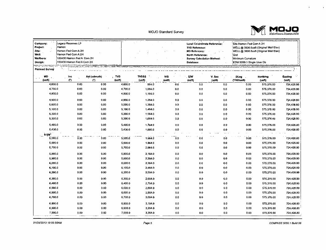
MOJO Standard Survey > r M O J Q
Company:
Project:
Sjte:
Well:
Wellbore:
Design:
Legacy Reserves LP
Hamon
Hamon Fed Com A 2H
Hamon Fed Com A 2H
130430 Hamon Fed A Com 2H
i 130430 Hamon Fed A Com 2H
Local Co-ordinate Reference:
TVD Reference:
MD Reference:
North Reference:
Survey Calculation Method:
Database:
Site Hamon Fed Com A 2H
WELL @ 3636.0usft (Original Well Elev)
WELL @ 3636.0usft (Original Well Elev)
Grid
Minimum Curvature
EDM 5000.1 Single User Db J Planned Survey s" -— —~ = ; - 1 •
MD (usft)
Inc
O Azi (azimuth)
n i TVD
(usft) TVDSS (usft)
N/S (usft)
. E/W (usft)
V.Sec (usft) -••
DLeg .. (•/100usft)
Northing (usft)
Easting (usft)
4,600.0 0.00 0.00 4,600.0 964.0 0.0 0.0 0.0 0.00 575,376.00 724,428.80
4,700.0 0.00 0.00 4,700.0 1,064.0 0.0 0.0 0.0 0.00 575,376.00 724,428.80
4,800.0 0.00 0.00 4,800.0 1,164.0 0.0 0.0 0.0 0.00 575.376.00 724,428.80
4,900.0 0.00 0.00 4,900.0 1,264.0 0.0 0.0 0.0 0.00 575,376.00 724,428.80
5,000.0 0.00 0.00 5,000.0 1,364.0 0.0 0.0 0.0 0.00 575,376.00 724,428.80
5,100.0 0.00 0.00 5,100.0 1,464.0 0.0 0.0 0.0 0.00 575,376.00 724,428.80
5,200.0 0.00 0.00 5,200.0 1,564.0 0.0 0.0 0.0 0.00 575,376.00 724,428.80
5,300.0 0.00 0.00 5,300.0 1,664.0 0.0 0.0 0.0 0.00 575,376.00 724,428.80
5,400.0 0.00 0.00 5,400.0 1,764.0 0.0 0.0 0.0 0.00 575,376.00 724,428.80
5,436.0 0.00 0.00 5,436.0 1,800.0 0.0 0.0 0.0 0.00 575,376.00 724,428.80
j 9 5/8" 5,500.0 0.00 - 0.00 5,500.0 1,864.0
. ' "o.o
.... " oo •— o7o 0.00 575.376.00 724,428.80
5,600.0 0.00 0.00 5,600.0 1,964.0 0.0 0.0 0.0 0.00 575,376.00 724,428.80
5,700.0 0.00 0.00 5,700.0 2,064.0 0.0 0.0 0.0 0.00 575,376.00 724,428.80
5,800.0 0.00 0.00 5,800.0 2,164.0 0.0 0.0 0.0 0.00 575,376.00 724,428.80
5,900.0 0.00 0.00 5,900.0 2,264.0 0.0 0.0 0.0 0.00 575,376.00 724,428.80
6,000.0 0.00 0.00 6,000.0 2,364.0 0.0 0.0 0.0 0.00 575,376.00 724,428.80
6,100.0 0.00 0.00 6,100.0 2,464.0 0.0 0.0 0.0 0.00 575,376.00 724,428.80
6,200.0 0.00 0.00 6,200.0 2,564.0 0.0 0.0 0.0 0.00 575,376.00 724,428.80
6,300.0 0.00 0.00 6,300.0 2,664.0 0.0 0.0 0.0 0.00 575,376.00 724,428.80
6,400.0 0.00 0.00 6,400.0 2,764.0 0.0 0.0 0.0 0.00 575,376.00 724,428.80
6,500.0 0.00 0.00 6,500.0 2,864.0 0.0 0.0 0.0 0.00 575,376.00 724,428.80
6,600.0 0.00 0.00 6,600.0 2,964.0 0.0 0.0 0.0 0.00 575,376.00 724,428.80
6,700.0 0.00 0.00 6,700.0 3,064.0 0.0 0.0 0.0 0.00 575,376.00 724,428.80
6,800.0 0.00 0.00 6,800.0 3,164.0 0.0 0.0 0.0 0.00 575,376.00 724,428.80
6,900.0 0.00 0.00 6,900.0 3,264.0 0.0 0.0 0.0 0.00 575,376.00 724,428.80
7,000.0 0.00 0.00 7,000.0 3,364.0 0.0 0.0 0.0 0.00 575,376.00 724,428.80
01/05/2013 10:50:58AM Page 5 COMPASS 5000.1 Build 56
MOJO Standard Survey i^pr M O J O
Company:
Project:
Site:
Well:
Wellbore:
Design:
Legacy Reserves LP
Hamon
Hamon Fed Com A 2H
Hamon Fed Com A 2H
130430 Hamon Fed A Com 2H
130430 Hamon Fed A Com 2H
Local Co-ordinate Reference:
TVD Reference:
MD Reference:
North Reference:
Survey Calculation Method:
Database:
Site Hamon Fed Com A 2H
WELL @ 3636.0usft (Original Well Elev)
WELL @ 3636.0usft (Original Well Elev)
Grid
Minimum Curvature
EDM 5000.1 Single User Db
Planned Survey I -- • - • .. .• =__ .̂.__ • •- • •• • — . i •
MD (usft)
Inc
o Azi (azimuth)
C) TVD (usft)
TVDSS (usft)
N/S (usfl)
E/W (usft)
V.Sec (usft)
DLeg (•/100usft)
Northing (usft)
Easting (usft)
7,100.0 0.00 0.00 7,100.0 3,464.0 0.0 0.0 0.0 0.00 575,376.00 724,428.80
7,200.0 0.00 0.00 7,200.0 3,564.0 0.0 0.0 0.0 0.00 575,376.00 724,428.80
7,300.0 0.00 0.00 7,300.0 3,664.0 0.0 0.0 0.0 0.00 575,376.00 724,428.80
7,400.0 0.00 0.00 7,400.0 3,764.0 0.0 0.0 0.0 0.00 575,376.00 724.428.80
7,500.0 0.00 0.00 7,500.0 3,864.0 0.0 0.0 0.0 0.00 575,376.00 724,428.80
7,600.0 0.00 0.00 7,600.0 3,964.0 0.0 0.0 0.0 0.00 575,376.00 724,428.80
7,700.0 0.00 0.00 7,700.0 4,064.0 0.0 0.0 0.0 0.00 575,376.00 724,428.80
7,800.0 0.00 0.00 7,800.0 4,164.0 0.0 0.0 0.0 0.00 575,376.00 724,428.80
7,900.0 0.00 0.00 7,900.0 4,264.0 0.0 0.0 0.0 0.00 575,376.00 724,428.80
8,000.0 0.00 0.00 8,000.0 4,364.0 0.0 0.0 0.0 0.00 575,376.00 724,428.80
8,100.0 0.00 0.00 8,100.0 4,464.0 0.0 0.0 0.0 0.00 575,376.00 724,428.80
8,200.0 0.00 0.00 8,200.0 4,564.0 0.0 0.0 0.0 0.00 575,376.00 724.428.80
8,300.0 0.00 0.00 8.300.0 4,664.0 0.0 0.0 0.0 0.00 575,376.00 724,428.80
8,400.0 0.00 0.00 8,400.0 4,764.0 0.0 0.0 0.0 0.00 575,376.00 724,428.80
8,500.0 0.00 0.00 8,500.0 4,864.0 0.0 0.0 0.0 0.00 575,376.00 724,428.80
8,600.0 0.00 0.00 8,600.0 4,964.0 0.0 0.0 0.0 0.00 575,376.00 724,428.80
8,700.0 0.00 0.00 8,700.0 5,064.0 0.0 0.0 0.0 0.00 575,376.00 724,428.80
8,600.0 0.00 0.00 8,800.0 5,164.0 0.0 0.0 0.0 0.00 575,376.00 724,428.80
8,900.0 0.00 0.00 8,900.0 5,264.0 0.0 0.0 0.0 0.00 575,376.00 724,428.80
9,000.0 0.00 0.00 9,000.0 5,364.0 0.0 0.0 0.0 0.00 575,376.00 724,428.80
9,100.0 0.00 0.00 9,100.0 5,464.0 0.0 0.0 0.0 0.00 575,376.00 724,428.80
9,200.0 0.00 0.00 9,200.0 5,564.0 0.0 0.0 0.0 0.00 575,376.00 724,428.80
9,300.0 0.00 0.00 9,300.0 5,664.0 0.0 0.0 0.0 0.00 575,376.00 724,428.80
9,392.0 0.00 0.00 9,392.0 5,756.0 0.0 0.0 0.0 0.00 575,376.00 724,428.80
' ' " B S P G iss" 9,400.0 0.00 0.00 9,400.0 5,764.0 0.0 0.0 b.o 0.00 * 575,376.00 724,428.80
9,500.0 0.00 0.00 9,500.0 5,864.0 0.0 0.0 0.0 0.00 575,376.00 724,428.80
01/05/2013 10:50:58AM Page 6 COMPASS 5000.1 Build 56
MOJO Standard Survey j ^ f i M O J O
Company: Legacy Reserves LP Local Coordinate Reference: Site Hamon Fed Com A 2H
Project: Hamon TVD Reference: WELL @ 3636.Ousft (Original Well Elev)
Site: Hamon Fed Com A 2H - • MD Reference: WELL @ 3636.0usft (Original Well Elev) [
Well: Hamon Fed Com A 2H • - North Reference: Grid j Wellbore: 130430 Hamon Fed A Com 2H Survey Calculation Method: Minimum Curvature
Design: 130430 Hamon Fed A Com 2H Database: EDM 5000.1 Single User Db j
Planned Survey
MD Inc Azi (azimuth) TVD TVDSS N/S E/W V.Sec DLeg Northing, Easting
(usft) . C) n (usft) (usft) (usft) (usft) (usft) (•/100usft)" (usft) (usft)
9,600.0 0.00 0.00 9,600.0 5,964.0 0.0 0.0 0.0 0.00 575,376.00 724,428.80
9,700.0 0.00 0.00 9,700.0 6,064.0 0.0 0.0 0.0 0.00 575,376.00 724,428.80
9,800.0 0.00 0.00 9,800.0 6,164.0 0.0 0.0 0.0 0.00 575,376.00 724,428.80
9,900.0 0.00 0.00 9,900.0 6,264.0 0.0 0.0 0.0 0.00 575,376.00 724,428.80
9,943.0 0.00 0.00 9,943.0 6,307.0 0.0 0.0 0.0 0.00 575,376.00 724,428.80
BSPG 2SS 10,000.0 " b ob 0.00 10.000.0 6^364.0 ~b"6 b.b b.o 0.00 575,376.00 724,428.80
10,100.0 0.00 0.00 10,100.0 6,464.0 0.0 0.0 0.0 0.00 575,376.00 724,428.80
10,200.0 0.00 0.00 10,200.0 6,564.0 0.0 0.0 0.0 0.00 575,376.00 724,428.80
10,300.0 0.00 0.00 10,300.0 6,664.0 0.0 0.0 0.0 0.00 575,376.00 724,428.80
10,322.0 0.00 0.00 10,322.0 6,686.0 0.0 0.0 0.0 0.00 575,376.00 724,428.80
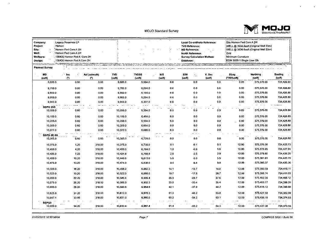
P BSPG 2D SS 10,365.0 0.00 0.00 10,365.0 6,729.0 0.0 0.0 0.0 0.00 575,376.00 724,428.80
10,375.0 1.20 318.00 10.375.0 6,739.0 0.1 -0.1 0.1 12.00 575,376.08 724,428.73
10,400.0 4.20 318.00 10,400.0 6,764.0 1.0 -0.9 1.0 12.00 575,376.95 724,427.94
10,425.0 7.20 318.00 10,424.8 6,788.8 2.8 -2.5 2.9 12.00 575,378.80 724,426.28
10,450.0 10.20 318.00 10,449.6 6,813.6 5.6 -5.0 5.9 12.00 575,381.61 724,423.75
10,475.0 13.20 318.00 10,474.0 6,838.0 9.4 -8.4 9.8 12.00 575,385.37 724,420.36
10,500.0 16.20 318.00 10,498.2 6,862.2 14.1 -12.7 14.8 12.00 575,390.09 724,416.11
10,525.0 19.20 318.00 10,522.0 6,886.0 19.7 -17.8 20.7 12.00 575,395.74 724,411.03
10,550.0 22.20 318.00 10,545.4 6,909.4 26.3 -23.7 27.6 12.00 575,402.30 724,405.12
10,575.0 25.20 318.00 10,568.3 6,932.3 33.8 -30.4 35.4 12.00 575,409.77 724,398.39
10,600.0 28.20 318.00 10,590.6 6,954.6 42.1 -37.9 44.2 12.00 575,418.12 724,390.88
10,625.0 31.20 318.00 10,612.3 6,976.3 51.3 -46.2 53.8 12.00 575,427.32 724,382.59
10,647.1 33.86 318.00 10,631.0 6,995.0 60.2 -54.2 63.1 12.00 575,436.16 724,374.63
BSPG3 10,650.0 34.20 318.00 10.633.4 6,997.4 61.4' -55.2 64.3" 12.00 ' 575,437.36 " 724,373.55
01/05/2013 10:50:58AM Page 7 COMPASS 5000.1 Build 56
o
MOJO Standard Survey > r M Q j p <Lj L-i iormcmoaia ccSpotuKcw
Company:
Project:
Site:
Well:
Wellbore:
Design:
Legacy Reserves LP
Hamon
Hamon Fed Com A 2H
Hamon Fed Com A 2H
130430 Hamon Fed A Com 2H
130430 Hamon Fed A Com 2H
Local Coordinate Reference:
TVD Reference:
MD Reference:
North Reference:
Survey Calculation Method:
Database:
ISite Hamon Fed Com A 2H
IWELL @ 3636.0usft (Original Well Elev)
[WELL @ 3636.0usft (Original Well Elev)
jGrid (Minimum Curvature -
[EDM 5000.1 Single User Db
. . . ..
Planned Survey I I -M —
MD (usft)
Inc
(*) Azi (azimuth)
C) TVD (usft)
TVDSS (usft)
N/S (usft)
E/W V. Sec (usft) (usft)
DLeg (°/100usft)
Northing (usft)
Easting
(usft)
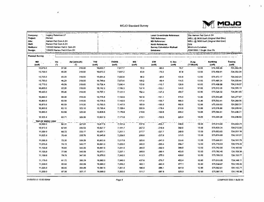
10,675 0 37.20 318.00 10,653.7 7,017.7 72.2 -65.0 75.7 12.00 575,448.20 724,363.79
10,700 0 40.20 318.00 10,673.2 7,037.2 83.8 -75.5 87.9 12.00 575,459.81 724,353.34
10,725 0 43.20 318.00 10,691.8 7,055.8 96.2 -86.6 100.8 12.00 575,472.17 724,342.21
10,750 0 46.20 318.00 10,709.6 7,073.6 109.2 -98.4 114.5 12.00 575,485.24 724,330.44
10,775 0 49.20 318.00 10,726.4 7,090.4 123.0 -110.7 128.9 12.00 575,498.98 724,318.07
10,800 0 52.20 318.00 10,742.3 7,106.3 137.4 -123.7 144.0 12.00 575,513.35 724,305.13
10,825 0 55.20 318.00 10,757.1 7,121.1 152.3 -137.2 159.7 12.00 575,528.32 724,291.65
10,850 0 58.20 318.00 10,770.8 7,134.8 167.8 -151.1 176.0 12.00 575,543.85 724.277.67
10,865 0 60.00 318.00 10,778.5 7,142.5 177.4 -159.7 186.0 12.00 575,553.41 724,269.06
10,875 0 60.59 319.20 10,783.5 7,147.5 183.9 -165.5 192.8 12.00 575,559.93 724,263.31
10,900 0 62.10 322.15 10,795.4 7,159.4 200.9 -179.4 210.6 12.00 575,576.90 724.249.42
10,925 0 63.68 325.02 10,806.8 7,170.8 218.8 -192.6 229.2 12.00 575,594.81 724,236.21
10,925 4 63.71 325.06 10,807.0 7,171.0 219.1 -192.8 229.4 12.00 575,595.08 724,236.02
TOP OF BSPG 3 PAY " ' " - _ . . . ' . . 10,950 0 65.31 327*81 10,817.6 ~ 7.1816 ~237.6~ ~ "-205Tl 248.6 * 12.00 575.613.60 724,223.74
10,975 0 67.00 330.53 10,827.7 7,191.7 257.2 -216.8 268.9 12.00 575,633.24 724,212.02
11,000 0 68.72 333.17 10,837.1 7,201.1 277.7 -227.7 289.9 12.00 575,653.65 724,201.10
11,025 0 70.49 335.76 10,845.8 7,209.8 298.8 -237.8 311.5 12.00 575,674.80 724,191.01
11,050 0 72.30 338.29 10,853.8 7,217.8 320.6 -247.0 333.8 12.00 575,696.61 724,181.76
11,075 0 74.13 340.77 10,861.0 7,225.0 343.0 -255.4 356.7 12.00 575,719.03 724,173.39
11,100 0 76.00 343.20 10,867.5 7,231.5 366.0 -262.9 380.0 12.00 575,742.00 724,165.93
11,125 0 77.88 345.59 10,873.1 7,237.1 389.5 -269.4 403.8 12.00 575,765.45 724,159.38
11,150 0 79.79 347.95 10,878.0 7,242.0 413.3 -275.0 428.0 12.00 575,789.33 724,153.77
11,175 0 81.72 350.29 10,882.0 7,246.0 437.6 -279.7 452.4 12.00 575,813.55 724,149.11
11,200 0 83.65 352.59 10.885.2 7,249.2 462.1 -283.4 477.1 12.00 575,838.07 724,145.42
11,225 0 85.60 354.89 10,887.5 7,251.5 486.8 -286.1 501.9 12.00 575,862.81 724,142.71
11,250 0 87.56 357.17 10,889.0 7,253.0 511.7 -287.8 526.9 12.00 575,887.70 724,140.98
01/05/2013 10:50:58AM Page 8 COMPASS 5000.1 Build 56
MOJO Standard Survey ( ^ f j M O J O
Company:
Project:
Site:
Well:
Wellbore: Design:
Legacy Reserves LP
Hamon
Hamon Fed Com A 2H
Hamon Fed Com A 2H
130430 Hamon Fed A Com 2H
130430 Hamon Fed A Com 2H
Local Co-ordinate Reference:
TVD Reference:
MD Reference:
North Reference:
Survey Calculation Method:
Database:
Site Hamon Fed Com A 2H
WELL @ 3636.0usfl (Original Well Elev)
WELL @ 3636.0usft (Original Well Elev)
Grid
Minimum Curvature
EDM 5000.1 Single User Db
= ? = — -]
Planned Survey I !
MD Inc Azi (azimuth) TVD TVDSS N/S E/W V.Sec DLeg Northing Easting (usft) n C) (usft) (usft) (usft) (usft) (usft) (•/100 usft) (usft) (usft)
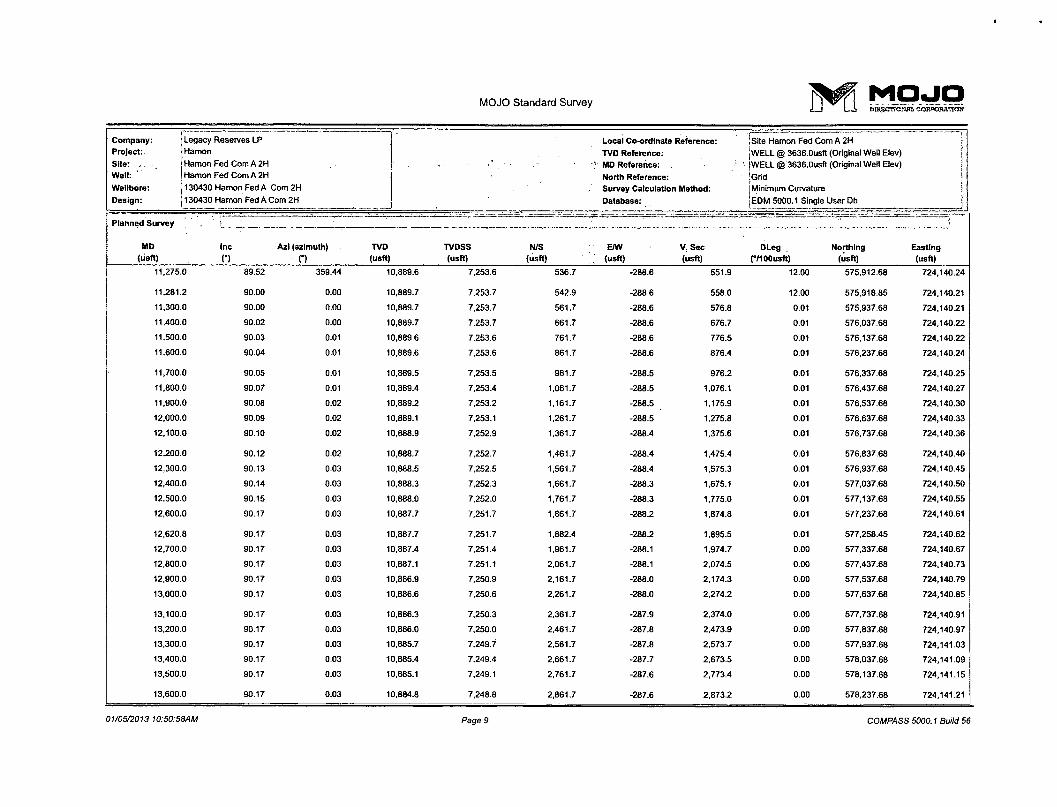
11,275.0 89.52 359.44 10,889.6 7,253.6 536.7 -288.6 551.9 12.00 575,912.68 724,140.24
11,281.2 90.00 0.00 10,889.7 7,253.7 542.9 -288.6 558.0 12.00 575,918.85 724,140.21
11,300.0 90.00 0.00 10,889.7 7,253.7 561.7 -288.6 576.8 0.01 575,937.68 724,140.21
11,400.0 90.02 0.00 10,889.7 7,253.7 661.7 -288.6 676.7 0.01 576,037.68 724,140.22
11,500.0 90.03 0.01 10,689.6 7,253.6 761.7 -288.6 776.5 0.01 576,137.68 724,140.22
11,600.0 90.04 0.01 10,889.6 7,253.6 861.7 -288.6 876.4 0.01 576,237.68 724,140.24
11,700.0 90.05 0.01 10,889.5 7,253.5 961.7 -288.5 976.2 0.01 576,337.68 724,140.25
11,800.0 90.07 0.01 10.889.4 7,253.4 1,061.7 -288.5 1,076.1 0.01 576,437.68 724,140.27
11,900.0 90.08 0.02 10,889.2 7,253.2 1,161.7 -288.5 1,175.9 0.01 576,537.68 724,140.30
12,000.0 90.09 0.02 10,889.1 7,253.1 1,261.7 -288.5 1,275.8 0.01 576,637.68 724,140.33
12,100.0 90.10 0.02 10,888.9 7,252.9 1,361.7 -288.4 1,375.6 0.01 576,737.68 724,140.36
12,200.0 90.12 0.02 10,888.7 7,252.7 1,461.7 -288.4 1,475.4 0.01 576,837.68 724,140.40
12,300.0 90.13 0.03 10,888.5 7,252.5 1,561.7 -288.4 1,575.3 0.01 576,937.68 724,140.45
12,400.0 90.14 0.03 10,888.3 7,252.3 1,661.7 -288.3 1,675.1 0.01 577,037.68 724,140.50
12,500.0 90.15 0.03 10,888.0 7,252.0 1,761.7 -288.3 1,775.0 0.01 577,137.68 724,140.55
12,600.0 90.17 0.03 10,887.7 7,251.7 1,861.7 -288.2 1,874.8 0.01 577,237.68 724,140.61
12,620.8 90.17 0.03 10,887.7 7,251.7 1,882.4 -288.2 1,895.5 0.01 577,258.45 724,140.62
12,700.0 90.17 0.03 10,887.4 7.251.4 1,961.7 -288.1 1,974.7 0.00 577,337.68 724,140.67
12,800.0 90.17 0.03 10,887.1 7,251.1 2,061.7 -288.1 2,074.5 0.00 577,437.68 724.140.73
12,900.0 90.17 0.03 10,886.9 7,250.9 2,161.7 -288.0 2,174.3 0.00 577,537.68 724,140.79
13,000.0 90.17 0.03 10,886.6 7,250.6 2,261.7 -288.0 2,274.2 0.00 577,637.68 724,140.85
13,100.0 90.17 0.03 10,886.3 7,250.3 2,361.7 -287.9 2,374.0 0.00 577,737.68 724,140.91
13,200.0 90.17 0.03 10,886.0 7,250.0 2,461.7 -287.8 2,473.9 0.00 577,837.68 724,140.97
13,300.0 90.17 0.03 10,885.7 7,249.7 2,561.7 -287.8 2,573.7 0.00 577,937.68 724,141.03
13,400.0 90.17 0.03 10,885.4 7,249.4 2,661.7 -287.7 2,673.5 0.00 578,037.68 724,141.09
13,500.0 90.17 0.03 10,885.1 7,249.1 2,761.7 -287.6 2,773.4 0.00 578,137.68 724,141.15
13,600.0 90.17 0.03 10,884.8 7,248.8 2,861.7 -287.6 2,873.2 0.00 578,237.68 724,141.21
01/05/2013 10:50:58AM Page 9 COMPASS 5000.1 Build 56

MOJO Standard Survey T^f j M O J O
Company:
Project:
Site:
Well:
Wellbore:
Design:
Legacy Reserves LP
Hamon
Hamon Fed Com A 2H
Hamon Fed Com A 2H
130430 Hamon Fed A Com 2H
130430 Hamon Fed A Com 2H
Local Coordinate Reference:
TVD Reference:
MD Reference:
North Reference:
Survey Calculation Method:
Database:
Site Hamon Fed Com A 2H
WELL @ 3636.0usft (Original Well Elev)
WELL @ 3636.0usft (Original Well Elev)
Grid
j Minimum Curvature
'EDM 5000.1 Single User Db
Planned Survey f . . ~— — .. = • • • -
_ _ _ _ J
MD - Inc Azi (azimuth) TVD TVDSS N/S E/W V. Sec DLeg Northing Easting (usft) o n (usft) (usft) (usft) (usft) (usft) f7100usft) (usft) (usft)
13,700.0 90.17 0.03 10,884.5 7,248.5 2,961.7 -287.5 2,973.1 0.00 578,337.68 724,141.27
13,800.0 90.17 0.03 10,884.2 7,248.2 3,061.7 -287.5 3,072.9 0.00 578,437.67 724,141.34
13,900.0 90.17 0.03 10,883.9 7,247.9 3,161.7 -287.4 3,172.8 0.00 578,537.67 724,141.40
14,000.0 90.17 0.03 10,883.6 7,247.6 3,261.7 -287.3 3,272.6 0.00 578,637.67 724,141.46
14,100.0 90.17 0.03 10,883.3 7,247.3 3,361.7 -287.3 3,372.4 0.00 578,737.67 724,141.52
14,200.0 90.17 0.03 10,883.0 7,247.0 3,461.7 -287.2 3,472.3 0.00 578,837.67 724,141.58
14,300.0 90.17 0.03 10,882.7 7,246.7 3.561.7 -287.2 3,572.1 0.00 578,937.67 724,141.64
' 14,400.0 90.17 0.03 10,882.4 7,246.4 3,661.7 -287.1 3,672.0 0.00 579.037.67 724,141.70
14,500.0 90.17 0.03 10,882.1 7,246.1 3,761.7 -287.0 3,771.8 0.00 579,137.67 724,141.76
14,600.0 90.17 0.03 10,881.8 7,245.8 3,861.7 -287.0 3,871.6 0.00 579,237.67 724,141.82
14,700.0 90.17 0.03 10,881.5 7,245.5 3,961.7 -286.9 3,971.5 0.00 579,337.67 724,141.88
14,800.0 90.17 0.03 10,881.2 7,245.2 4,061.7 -286.9 4,071.3 0.00 579,437.67 724,141.94
14,900.0 90.17 0.03 10,880.9 7,244.9 4,161.7 -286.8 4.171.2 0.00 579,537.67 724,142.00
15,000.0 90.17 0.03 10,880.6 7,244.6 4,261.7 -286.7 4,271.0 0.00 579,637.67 724,142.06
15,100.0 90.17 0.03 10,880.3 7,244.3 4,361.7 -286.7 4,370.9 o.oo 579,737.67 724,142.13
15,200.0 90.17 0.03 10,880.0 7,244.0 4,461.7 -286.6 4,470.7 0.00 579,837.67 724,142.19
15,300.0 90.17 0.03 10,879.7 7,243.7 4.561.7 -286.6 4,570.5 0.00 579,937.67 724,142.25
15,400.0 90.17 0.03 10,879.4 7,243.4 4,661.7 -286.5 4,670.4 0.00 580,037.67 724,142.31
15,500.0 90.17 0.03 10,879.1 7,243.1 4,761.7 -286.4 4,770.2 0.00 580,137.67 724,142.37
15,600.0 90.17 0.03 10,878.8 7,242.8 4,861.7 -286.4 4,870.1 0.00 580,237.67 724,142.43
15,700.0 90.17 0.03 10,878.5 7,242.5 4,961.7 -286.3 4,969.9 0.00 580,337.67 724,142.49
15,800.0 90.17 0.03 10,878.3 7,242.3 5,061.7 -286.2 5,069.8 0.00 580,437.67 724,142.55
15,847.2 90.17 0.03 10,878.1 7,242.1 5,108.9 -286.2 5,116.9 0.00 580,484.88 724,142.58
15,884.3 90.17 0.03 10,878.0 7,242.0 5,146.0 -286.2 5,153.9 0.01 580,521.97 724,142.60
5 1/2" . ' ' - ... . ... . —,
01/05/2013 10:50:58AM Page 10 COMPASS 5000.1 Build 56
MOJO Standard Survey > r M O J O
Company: Legacy Reserves LP Local Co-ordinate Reference: jSite Hamon Fed Com A 2H Project: Hamon TVD Reference: jWELL @ 3636.0usft (Original Well Elev) Site: Hamon Fed Com A 2H MD Reference: jWELL @ 3636.0usft (Original Well Elev) Weil: Hamon Fed Com A 2H North Reference: |Grid Wellbore: 130430 Hamon Fed A Com2H Survey Calculation Method: iMinimum Curvature
Design: 130430 Hamon Fed A Com 2H Database: 'EDM 5000.1 Single User Db
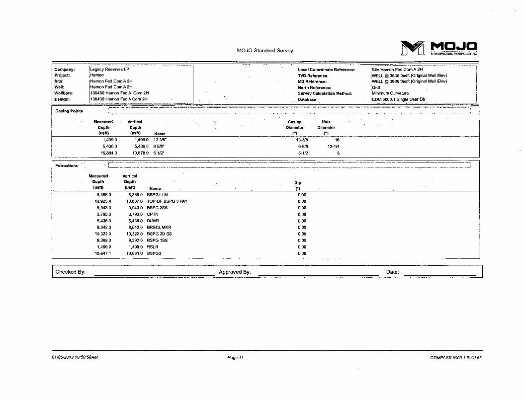
Casing Points f . , . ^ . —.
Measured Vertical Casing Hole Depth Depth Diameter Diameter (usft) (usft) Name n n
1,499.0 1,499.0 13 3/8" 13-3/8 16
5,436.0 5,436.0 9 5/8" 9-5/8 12-1/4
15,884.3 10,878.0 5 1/2" 5-1/2 6
Formations
Measured Vertical Depth Depth Dip
("««) ("5ft) N a m e • (•)
8,368.0 8,368.0 BSPG1 LM 0.00
10,925.4 10,807.0 TOP OF BSPG 3 PAY 0.00
9,943.0 9,943.0 BSPG 2SS 0.00
3,793.0 3,793.0 CPTN 0.00
5,436.0 5,436.0 DLWR 0.00
8,042.0 8,042.0 BRSCL MKR 0.00
10,322.0 10,322.0 BSPG 2D SS 0.00
9,392.0 9,392.0 BSPG 1SS 0.00
1,499.0 1,499.0 RSLR 0.00
10,647.1 10,631.0 BSPG3 0.00
Checked By: Approved By: Date:
01/05/2013 10:50:58AM Page 11 COMPASS 5000.1 Build 56
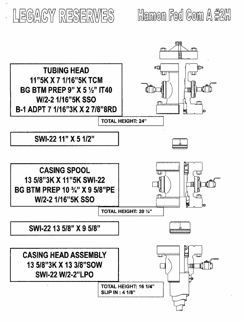
m mm M
SWI-2211"X51/2"
SHL
TUBING HEAD 11"5KX71/16"5KTCM
BG BTM PREP 9" X 51/2" IT40 W/2-21/16"5K SSO
B-1 ADPT71/16"3KX2 7/8"8RD
5 TUBING HEAD 11"5KX71/16"5KTCM
BG BTM PREP 9" X 51/2" IT40 W/2-21/16"5K SSO
B-1 ADPT71/16"3KX2 7/8"8RD
ILU
rm P TUBING HEAD
11"5KX71/16"5KTCM BG BTM PREP 9" X 51/2" IT40
W/2-21/16"5K SSO B-1 ADPT71/16"3KX2 7/8"8RD
TOTAL HEIGHT: 24"
inr
01
CASING SPOOL 13 5/8"3KX11"5KSWI-22
BG BTM PREP 10 %' X 9 5/8"PE W/2-2 1/16"5K SSO
91
TOTAL HEIGHT: 20 %"
SWI-2213 5/8"X9 5/8"
g nni
a On
CASING HEAD ASSEMBLY 13 5/8"3KX13 3/8"SOW
SWI-22 W/2-2"LPO TOTAL HEIGHT: 16 1/4" SLIP IN : 4 1/8"
3 (fTUi
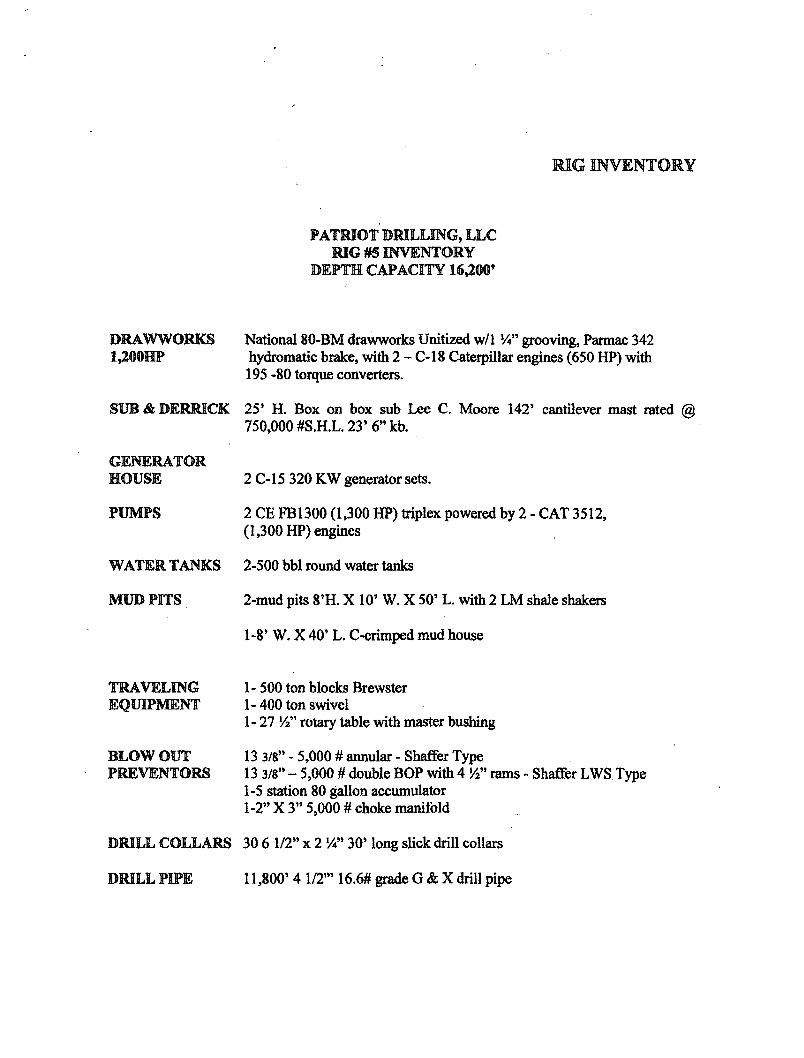
RIG INVENTORY
PATRIOT DRILLING, LLC RIG #5 INVENTORY
DEPTH CAPACITY 16,200'
DRAWWORKS 1,200HP
National 80-BM drawworks Unitized w/1 V" grooving, Parmac 342 hydromatic brake, with 2 - C-18 Caterpillar engines (650 HP) with 195 -80 torque converters.
SUB & DERRICK 25' H. Box on box sub Lee C. Moore 142' cantilever mast rated @ 750,000 #S.H.L. 23' 6" kb.
GENERATOR HOUSE
PUMPS
2 C-15 320 KW generator sets.
2 CE FB1300 (1,300 HP) triplex powered by 2 - CAT 3512, (1,300 HP) engines
WATER TANKS 2-500 bbl round water tanks
MUD PITS 2-mud pits 8'H. X 10' W. X 50' L. with 2 LM shale shakers
1-8' W. X 40' L. C-crimped mud house
TRAVELING EQUIPMENT
BLOW OUT PREVENTORS
1- 500 ton blocks Brewster 1-400 ton swivel
1- 27 Vi" rotary table with master bushing
13 3/8" - 5,000 # annular - Shaffer Type 13 3/8" - 5,000 # double BOP with 4 »/2" rams - Shaffer LWS Type 1-5 station 80 gallon accumulator 1-2" X 3" 5,000 # choke manifold
DRILL COLLARS 30 6 1/2" x 2 %" 30' long slick drill collars
DRILL PIPE 11,800' 4 1/2"' 16.6# grade G & X drill pipe