Embed Size (px)
Citation preview
René C
hartrandFren
ch Fo
rtresses in N
orth
Am
erica 15
35
–1
76
3
OSPREYP U B L I S H I N G
Following the discovery of
America by Columbus in 1492,
European colonists brought
their system of fortification to
the New World in an attempt to
consolidate their conquests.
French and British explorers
came later to North America, and
thus the establishment of their
sizeable settlements only got
under way during the 17th
century. The inhabitants of
New France built elaborate
fortifications to protect their
towns and cities, and this book
provides a detailed examination
of the defenses of four of them:
Québec, Montréal and Louisbourg
in Canada, and New Orleans in
Louisiana.
www.ospreypublishing.com
Full color artwork
Photographs
a k ee u x -t a g n e s
L a k eS a i n t - L o u i s
Fort atSainte-Anne-de-Bellevue
Fort atIle Perrot
Fort Sennevilleand nearby fortified mill
Fort atPointe-Claire
Fort Gentilly
Fort Rolland
FortSault-Saint-Louis
Fort La Prairie
Fort RémyFortCuillerier
FortVerdun
FortIle Saint-Bernard
Fort Saint-Lambert
Forts onSaint-Paul Island
Fort de la Montagne
FortSaint-Gabriel
Montréal
FortLongue-Pointe
Fort Sainte-Marie
Fort Longeuil
Fort Le Tre
F
Fort Pointe-aux-Trembles
FortRivière-des-Pariries
Fort Lorette
D e sP r a i r i e
sR
iv
er
S t .L a w
r en
c
eR
iv
er
M O N T R ÉA
L
I
SL
AN
D
Rapids
500 miles
500 km
Mapping
Unrivaled detail
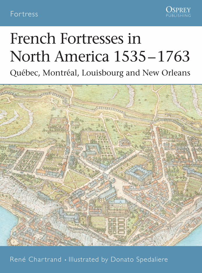
French Fortresses in North America 1535–1763Québec, Montréal, Louisbourg and New Orleans
For tress • 27
Fortress
• 27
Design, technology and history of key for tresses,
strategic positions and defensive systems
For tress
French Fortressesin North America1535 – 1763Québec, Montréal,Louisbourg and New Orleans
OSPREYP U B L I S H I N G
René Char trand • Illustrated by Donato Spedaliere
OSPR
EY
FOR27coverUK.qxd:FOR27coverUK.qxd 11/3/09 15:52 Page 1
For tress • 27
French Fortresses inNorth America 1535–1763Québec, Montréal, Louisbourg and New Orleans
René Char trand • Illustrated by Donato SpedaliereSeries editors Marcus Cowper and Nikolai Bogdanovic
FOR027title.qxd:FOR027title.qxd 11/3/09 15:54 Page 1
First published in Great Britain in 2005 by Osprey Publishing, Elms Court, Chapel Way, Botley, Oxford OX2 9LP, United Kingdom. Email: [email protected]
© 2005 Osprey Publishing Ltd.
All rights reserved. Apart from any fair dealing for the purpose of private study,research, criticism or review, as permitted under the Copyright, Designs and PatentsAct, 1988, no part of this publication may be reproduced, stored in a retrieval system,or transmitted in any form or by any means, electronic, electrical, chemical, mechanical,optical, photocopying, recording or otherwise, without the prior written permissionof the copyright owner. Enquiries should be addressed to the Publishers.
ISBN 1 84176 714 X
Editorial: Ilios Publishing, Oxford, UK (www.iliospublishing.com)Design: Ken Vail Graphic Design, Cambridge, UKIndex by David WorthingtonMaps by The Map Studio LtdOriginated by The Electronic Page Company, Cwmbran, UKPrinted and bound in China by L Rex Printing Company Ltd..
05 06 07 08 09 10 9 8 7 6 5 4 3 2 1
A CIP catalog record for this book is available from the British Library.
FOR A CATALOG OF ALL BOOKS PUBLISHED BY OSPREY MILITARY AND AVIATION
PLEASE CONTACT:
NORTH AMERICAOsprey Direct, 2427 Bond Street, University Park, IL 60466, USAE-mail: [email protected]
ALL OTHER REGIONSOsprey Direct UK, P.O. Box 140, Wellingborough, Northants, NN8 2FA, UK E-mail: [email protected]
www.ospreypublishing.com
© Osprey Publishing. Access to this book is not digitally restricted. In return,we ask you that you use it for personal, non-commercial purposes only. Pleasedon’t upload this pdf to a peer-to-peer site, email it to everyone you know, orresell it. Osprey Publishing reserves all rights to its digital content and no partof these products may be copied, stored in a retrieval system or transmittedin any form by any means, electronic, mechanical, recording or otherwise(except as permitted here), without the written permission of the publisher.Please support our continuing book publishing programme by using this pdfresponsibly.
The Fortress Study Group (FSG)
The object of the FSG is to advance the education of the public inthe study of all aspects of fortifications and their armaments,especially works constructed to mount or resist artillery. The FSGholds an annual conference in September over a long weekendwith visits and evening lectures, an annual tour abroad lastingabout eight days, and an annual Members’ Day.
The FSG journal FORT is published annually, and its newsletterCasemate is published three times a year. Membership isinternational. For further details, please contact:
The Secretary, c/o 6 Lanark Place, London W9 1BS, UK
Acknowledgments
The author is grateful to his many colleagues at Parks Canada,notably those at Fortress Louisbourg, the Fortifications of Québecand at the national HQ in Ottawa. Also Claire Mousseau, chiefarchaeologist of the City of Montréal, the staff of the NationalArchives and Library of Canada and of the Archives Nationales inFrance..
Artist’s note
Our sincere thanks to all who have helped in the preparation ofthis book. We would like to dedicate this book to our dearestdaughter Alina.Readers may care to note that the original paintings from whichthe colour plates in this book were prepared are available forprivate sale. All reproduction copyright whatsoever is retained bythe Publishers. All enquiries should be addressed to:
Sarah SulemsohnTel-Fax: 00 39 0575 [email protected] [email protected] www.alinaillustrazioni.com
The Publishers regret that they can enter into no correspondenceupon this matter.
Author’s Note
“In the new colonies, the Spanish start by building a church, theEnglish a tavern and the French a fort.” There was some truth inthis tongue-in-cheek remark by the great French author René deChateaubriand (1768–1848); New France eventually had a NorthAmerican network of numerous forts, big and small, extendingfrom the Gulf of St. Lawrence to the Gulf of Mexico and westinto the present-day Canadian and American prairies. There werealso fortresses, the subject of this study, as the main towns werefortified. Fortresses such as Louisbourg and Québec have beenrightly famed for their extensive fortifications, Québec having theadvantage of a formidable natural site. However, few people todaywould guess that Montréal and New Orleans could also betermed fortresses, for they were once enclosed by bastionedwalls and moats. Although their fortifications were relativelymodest and meant to deter raiders rather than fully fledgedarmies, both cities were surrounded by numerous outlying forts.These provided early warning and acted as an outer buffer, afeature peculiar to the fortress cities situated at the hub of greatNorth American rivers.
Measures
These have varied over the centuries and varied from one nationto another. In New France, weights and measures were thoseused by the mother country. It is most important to note that theFrench foot, used in New France, was longer (12.789 inches) thanthe British foot (12 inches). The official French measures from1668 to 1840 were:
2 miles = 1 Lieue = 3.898 kilometers1,000 Toises = 1 mile = 1.949 kilometers
(British = 1.61 kilometers)6 feet = 1 Toise = 1.949 meters
(British Fathom = 1.83 meters)12 inches = 1 foot = 32.484 centimeters
(British = 30.48 centimeters)12 lines = 1 inch = 2.707 centimeters
(British = 2.54 centimeters)
08098 FOR27corre.qxd:08098 FOR27corre.qxd 16/3/09 10:36 Page 2
Contents
Introduction 4
Chronology 7
The King’s Engineers 8
Québec 11The mightiest site on the continent • The 1690 siege • Improvements • The 1759 siege • The 1760 siege
Trois-Rivières 30
Montréal 32Palisades and ramparts • Montréal island’s outlying forts • The 1760 capitulation
Louisbourg 45Building the fortress • The 1745 siege • Returned to French possession • The 1758 siege
New Orleans 52Outlying forts and batteries • Ramparts and batteries
The sites today 60
Select bibliography 61
Glossary 62
Index 64
08098 FOR27corre.qxd:08098 FOR27corre.qxd 16/3/09 10:36 Page 3
Following the discovery of America by Columbus in 1492, European colonistsbuilt their style of fortification in the New World in an attempt to ensure theirsafety and consolidate their conquests. The Spanish and Portuguese were thefirst to build sizeable forts, some of which evolved into fortified towns—fortresses—as their settlements grew. San Juan (Puerto Rico), Havana (Cuba),Cartagena de Indias (Colombia) and several others in the “Spanish Main” andSouth America were already renowned by the 17th century. The French and theBritish came later to North America and thus the establishment of their sizeablepermanent settlements only got under way during the 17th century. TheBritish colonists rapidly outgrew their small stockaded settlements along theNorth American coastline but did not build elaborate fortifications to protecttheir towns. Their French neighbors did.
From the early 17th century until the end of the Seven Years War in 1763,the greater part of North America came under the French realm and much of itwas called La Nouvelle-France (New France). Thanks to relentless explorers andtraders, the land mass of New France was enormous, extending from the Gulfof St. Lawrence to the Rocky Mountains in the west and from the Great Lakesto the Gulf of Mexico in the south. But as impressive as it may have looked ona map, New France remained a weak colony in terms of population, which wassparse and scattered. It had only about 500 French inhabitants in 1641, some14,000 in 1689 and perhaps 80,000 of French origin by the 1750s.
In the early 17th century, New France was divided into two administrativeentities. The largest and most important was the colony of Canada, whichincluded the settled areas in the St. Lawrence Valley with the three towns ofMontréal, Trois-Rivières and Québec. It also extended into the westernwilderness as far as it had been explored, an ongoing process. On the Atlanticseaboard was the small colony of Acadia whose settlements were spread in partsof present-day Nova Scotia, New Brunswick and Maine. On the island ofNewfoundland was the port of Placentia that formed a small colony. Followingthe cession of Acadia and Placentia to Britain by the Treaty of Utrecht in 1713,the garrisons and some of the settlers were moved to Cape Breton Island,subsequently renamed Isle Royale, where, from 1720, the fortress of Louisbourgwas built.
Further south, the French had reached the Gulf of Mexico in 1682 bycoming down the Mississippi River and, from 1699, settlements wereestablished on the coast to make up the third entity, the colony of Louisiana,in the present-day states of Alabama, Mississippi and Louisiana. Today arelatively small American state, Louisiana in the 18th century covered anenormous territory extending from Canada to the Gulf of Mexico. Louisiana’spopulation was modest and its settlements were concentrated on the GulfCoast and in Les Illinois (also called Upper Louisiana), in the general area ofpresent-day St. Louis.
The government of New France was patterned after that of a Frenchprovince. The governor-general of New France, who resided in Québec, hadoverall authority and was commander-in-chief. He was assisted by theintendant in financial and civic matters and the bishop in religious issues, theirrespective powers being devolved to local governors, commissaries and seniorpriests. In Canada, there were local governors in Montréal and Québec. IsleRoyale’s governor was in Louisbourg and Louisiana’s governor was in NewOrleans. Although nominally subordinate to the governor-general in Québec,4
Introduction
08098 FOR27corre.qxd:08098 FOR27corre.qxd 16/3/09 10:36 Page 4
the governors of Isle Royale and Louisiana were independent as they reporteddirectly to the minister responsible for naval and colonial affairs in Versailles.Canada, the Atlantic seaboard colonies and Louisiana each had their respectivegarrisons of colonial troops.
The fortresses of New France studied in this book—that is to say, substantialtowns and cities enclosed by protective walls—were extraordinary in theirvariety. (The term place forte rather than forteresse was generally used by theFrench to denote a town surrounded by fortifications until the 1870s.) Québecwas a formidable natural fortress; the defenses of Louisbourg were almosttransposed from Vauban’s textbooks; Montréal had a substantial wall and NewOrleans was eventually also protected by moats and redoubts. Although quitedifferent in fortification style and extent, Québec, Montréal, Louisbourg andNew Orleans all had one thing in common: their strategic importance wastremendous and the fall of any one of them practically ensured the fall of theirentire area.
Except for New Orleans, all were besieged during the 17th and 18thcenturies. Québec resisted in 1690 but fell in 1759; its henceforth Britishgarrison would resist in 1760, and again (against the Americans) in 1775–76.Louisbourg fell twice, in 1745 and 1758, after great sieges. Montréal held thelast French army in Canada when it surrendered to three British armies inSeptember 1760. Only New Orleans escaped being besieged although treatiessigned in Europe passed it from France to Spain in 1763, to France again in1802 and finally to the United States of America in 1803.
One town that never quite made it as a fortress was Trois-Rivières, althoughit was enclosed by a palisade wall. Founded in 1634, it quickly lost its strategicand economic importance after Montréal was settled in 1642. As will be seen 5
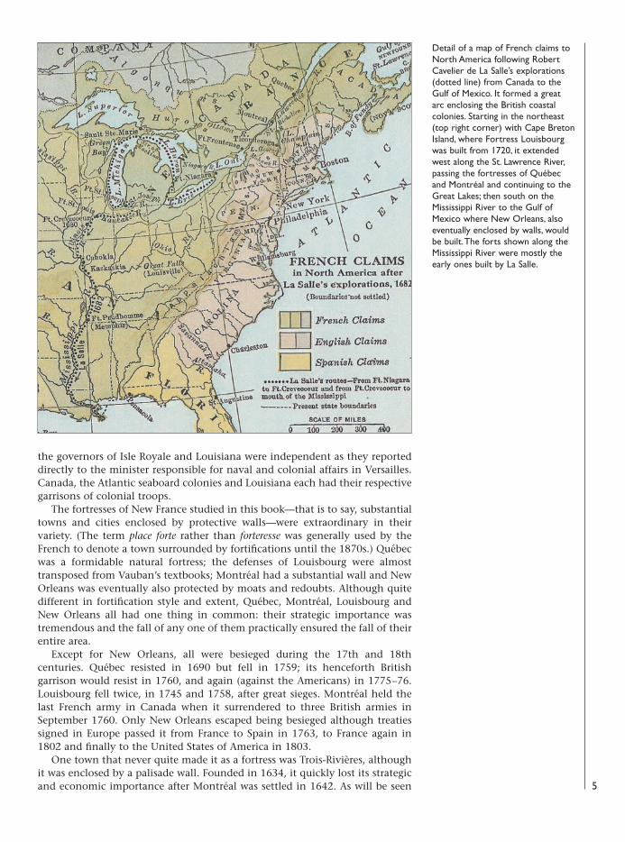
Detail of a map of French claims toNorth America following RobertCavelier de La Salle’s explorations(dotted line) from Canada to theGulf of Mexico. It formed a greatarc enclosing the British coastalcolonies. Starting in the northeast(top right corner) with Cape BretonIsland, where Fortress Louisbourgwas built from 1720, it extendedwest along the St. Lawrence River,passing the fortresses of Québecand Montréal and continuing to theGreat Lakes; then south on theMississippi River to the Gulf ofMexico where New Orleans, alsoeventually enclosed by walls, wouldbe built. The forts shown along theMississippi River were mostly theearly ones built by La Salle.
08098 FOR27corre.qxd:08098 FOR27corre.qxd 16/3/09 10:36 Page 5
later, its meager defenses hadbecome useless by the middle ofthe 18th century.
Each major town was capital toan area. Québec was simul-taneously the capital of NewFrance, the colony of Canada andthe district of Québec. Trois-Rivières and Montréal wererespectively the capitals of theirdistricts of Trois-Rivières andMontréal. Louisbourg was thecapital of the colony of Isle Royale(Cape Breton Island) and NewOrleans was the capital ofLouisiana.
Within the French colonialadministrative system, thesetowns—Québec, Trois-Rivières,Montréal, Louisbourg and NewOrleans—were the seats ofgovernors and their retinues ofgarrison staff officers. Principalamong these were the Lieutenantdu Roi (King’s Lieutenant, ineffect the lieutenant governor),the Major de Place (Town Major,often assisted by an assistantmajor) and, in major cities, aCapitaine des Portes (Captain ofthe Gates, a medieval title todenote the officer in charge ofsecurity). In the case of Québec,the governor-general of New
France resided there and was also the town’s governor. His prestige was of thehighest order and some of the honor due to him equaled that of marshals inFrance. Drum rolls greeted him when he came into or out of his château; hewas allowed an escort of his own guards; he enjoyed cannon salutes whenarriving in towns and he would be addressed as Monseigneur (My Lord). He hada staff of several officers including the senior Ingénieur du Roi (King’s Engineer)in the colony and the captain of his guards acted as an aide-de-camp.
Next in line to the governor-general was the intendant, the most importantcivil official, who also resided in Québec City. By protocol a subordinate to thegovernor-general, the intendant was his equal regarding financial management(including military budgets), legal matters and commerce, all of which were hisresponsibility. His subalterns, the Commissaire-ordonnateur, were to be found inall fortress towns except Trois-Rivières. The intendant and a colony’sCommissaire-ordonnateur ranked as high civil officials and enjoyed an escort ofan Archer (police constable) on formal occasions.
6
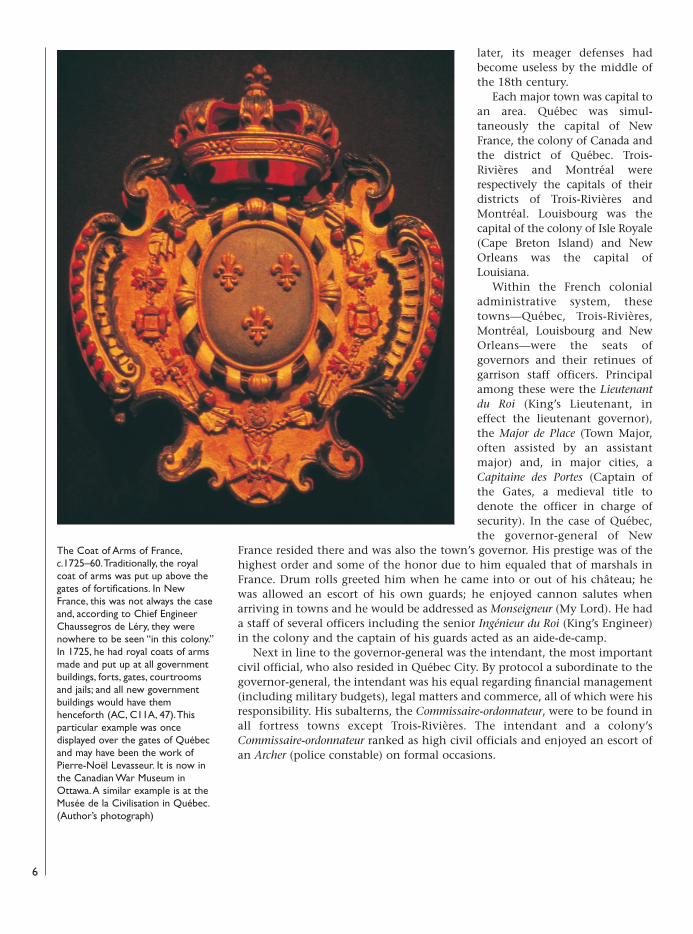
The Coat of Arms of France,c.1725–60. Traditionally, the royalcoat of arms was put up above thegates of fortifications. In NewFrance, this was not always the caseand, according to Chief EngineerChaussegros de Léry, they werenowhere to be seen “in this colony.”In 1725, he had royal coats of armsmade and put up at all governmentbuildings, forts, gates, courtroomsand jails; and all new governmentbuildings would have themhenceforth (AC, C11A, 47). Thisparticular example was oncedisplayed over the gates of Québecand may have been the work ofPierre-Noël Levasseur. It is now inthe Canadian War Museum inOttawa. A similar example is at theMusée de la Civilisation in Québec.(Author’s photograph)
08098 FOR27corre.qxd:08098 FOR27corre.qxd 16/3/09 10:37 Page 6
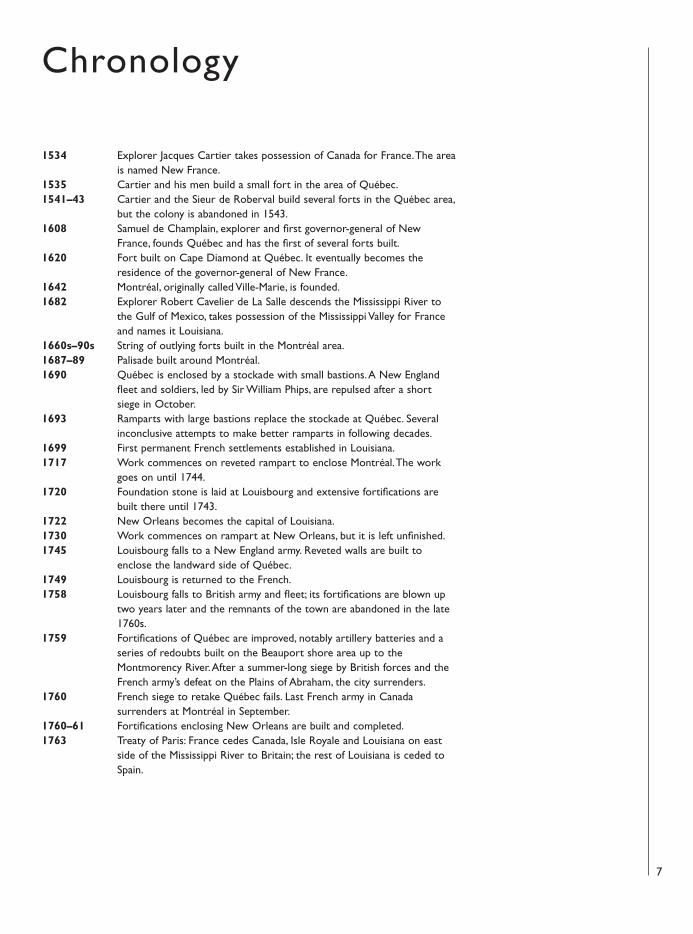
1534 Explorer Jacques Cartier takes possession of Canada for France. The areais named New France.
1535 Cartier and his men build a small fort in the area of Québec.1541–43 Cartier and the Sieur de Roberval build several forts in the Québec area,
but the colony is abandoned in 1543.1608 Samuel de Champlain, explorer and first governor-general of New
France, founds Québec and has the first of several forts built.1620 Fort built on Cape Diamond at Québec. It eventually becomes the
residence of the governor-general of New France. 1642 Montréal, originally called Ville-Marie, is founded.1682 Explorer Robert Cavelier de La Salle descends the Mississippi River to
the Gulf of Mexico, takes possession of the Mississippi Valley for Franceand names it Louisiana.
1660s–90s String of outlying forts built in the Montréal area.1687–89 Palisade built around Montréal. 1690 Québec is enclosed by a stockade with small bastions. A New England
fleet and soldiers, led by Sir William Phips, are repulsed after a shortsiege in October.
1693 Ramparts with large bastions replace the stockade at Québec. Severalinconclusive attempts to make better ramparts in following decades.
1699 First permanent French settlements established in Louisiana.1717 Work commences on reveted rampart to enclose Montréal. The work
goes on until 1744. 1720 Foundation stone is laid at Louisbourg and extensive fortifications are
built there until 1743.1722 New Orleans becomes the capital of Louisiana.1730 Work commences on rampart at New Orleans, but it is left unfinished.1745 Louisbourg falls to a New England army. Reveted walls are built to
enclose the landward side of Québec.1749 Louisbourg is returned to the French.1758 Louisbourg falls to British army and fleet; its fortifications are blown up
two years later and the remnants of the town are abandoned in the late1760s.
1759 Fortifications of Québec are improved, notably artillery batteries and aseries of redoubts built on the Beauport shore area up to theMontmorency River. After a summer-long siege by British forces and theFrench army’s defeat on the Plains of Abraham, the city surrenders.
1760 French siege to retake Québec fails. Last French army in Canadasurrenders at Montréal in September.
1760–61 Fortifications enclosing New Orleans are built and completed.1763 Treaty of Paris: France cedes Canada, Isle Royale and Louisiana on east
side of the Mississippi River to Britain; the rest of Louisiana is ceded toSpain.
7
Chronology
08098 FOR27corre.qxd:08098 FOR27corre.qxd 16/3/09 10:37 Page 7
The theoretical education of French engineers in the age of Louis XIV(1643–1715) and Louis XV (1715–74) was remarkably good by the standards ofthe day and covered aspects of engineering, tactics, architecture, fine arts andtown planning. Geometry was the main element of European militaryarchitecture since the end of the Middle Ages and the introduction of artilleryin siege warfare. The large castles with high walls and turrets were obsolete asthey could be demolished by cannonballs. New ways had to be found to protectstrongholds; obviously, the walls and towers would have to be lower and wider,made of stone frames filled with earth, so as to accommodate artillery for thedefenders while making it much more difficult for the besieger to breech thewalls. By the 1480s, Italian military engineers had conceived the corner bastionthat became, quite literally, the cornerstone of fortifications for centuries tocome. Renaissance engineers in Italy published a multitude of geometric designswith bastions and moats at all angles to enclose a city with fortifications as wellas laying out city streets and squares in an orderly fashion. Some were fancifulbut, on the whole, they offered effective ways to defend a city in a Europeanmilitary context. From the late 16th century and during the 17th century, majorwars were often fought in mostly flat terrain of Flanders where geometricdesigns could be built almost flawlessly. The Dutch engineers now becameleaders in military architecture, devising enormous earthworks that weresurrounded by large water-filled moats thanks to the high water table of thatarea. Menno van Coehorn (1641–1704) was the leading Dutch engineer whoseintricate fortification designs and the use of water as an obstacle were muchadmired.
The French were also keenly interested in fortifications and had, since theRenaissance, applied the “Italian tracing” to their fortress designs while addingfeatures of their own. The French approach was more systematic thanelsewhere and, as early as 1604, a nationwide administrative regulationconcerning fortifications was put in place. This brought an increasingprofessionalization of military engineering, which coincided with the adventof Sébastien Le Preste de Vauban (1633–1707), one of the greatest engineers inmilitary history. Part of Vauban’s remarkable success was due to his pragmaticapproach; he was not merely a theoretician with skills in geometry, he was alsoa veteran military engineer in the field who conducted some 48 sieges duringhis career. Vauban’s elaborate systems of fortifications thus combined andenhanced designs proven effective in actual siege warfare, hence their renown.Louis XIV, recognizing Vauban’s great talent, made him nationalsuperintendent of fortifications and tasked him with building or repairing amultitude of forts and fortresses all over France, but especially in Flanders,where the king wanted a line of fortresses built to prevent enemy incursions.This vast public works project, which went on for decades, required numbersof qualified engineers. Previously, more or less gifted amateurs had beensomewhat self-proclaimed “engineers” who largely acquired their knowledgefrom engineering books published mostly in Italy and in Holland. Louis XIVfelt that military engineering was a state secret and that Vauban’s manuals onfortifications, on the ways to attack and defend fortresses should not bepublished. Thus, those selected to be military engineers had no printedmanuals from Vauban; instead part of their training was to make a manuscriptcopy of Vauban’s treatises, which they would keep as their main reference workafterwards.8
The King’s Engineers
08098 FOR27corre.qxd:08098 FOR27corre.qxd 16/3/09 10:37 Page 8
In France, the men responsible for designing and building fortifications werethe “King’s Engineers” (Ingénieurs du Roi). These were highly skilled andeducated individuals who held royal commissions—hence being called the“King’s”—to practice their art in government service. They combined thepresent-day skills of architecture, military and civil engineering, and urbanplanning. While primarily concerned with fortifications, they could also becalled upon to design churches, windmills, warehouses, etc. The King’sEngineers also had military officers’ commissions to provide them with a rank,usually that of captain, within the military structure. They were employed asstaff officers and would also be found in the entourage of a colonial governor orgovernor-general.
Under Marshal Vauban’s leadership, the King’s Engineers formed a sort ofsmall independent ministry whose staff was spread all over France and itscolonies. This state of affairs continued following Vauban’s death. The Marquisd’Asfeld, his successor, was a skilled soldier and courtier who, during hislifetime, managed to keep the engineers from being amalgamated. In 1732, heintroduced a colorful uniform for the King’s Engineers consisting of a scarletcoat with blue cuffs, scarlet waistcoat and breeches, gilt buttons set in pairs, adress that certainly distinguished them from most officers in the armed forces.
In March 1743, the Marquis d’Asfeld passed away and the engineers’independence came to an end. Most were absorbed into the army in Francewith others going to the navy. As the navy was responsible for the colonies inAmerica, there were hardly any changes for the engineers posted to the varioustowns who continued to be called the King’s Engineers and wear their scarletuniforms. From the time of the Seven Years War, metropolitan army engineerswere sent to Canada and other colonies and served mostly in the field as withMontcalm’s army. The colonial King’s Engineers continued to be mostlypreoccupied by fortifications, sometimes quite far into the wilderness interiorof the continent.
Engineers were active in Canada from the early decades of the 17th century,most notably Jacques Bourdon, who was active in Québec from 1634 to 1668.A regular establishment of engineers under a chief engineer was set up in thelate 17th century. Robert de Villeneuve first had the post from 1685 to 1693.Jacques Levasseur de Néré was named to succeed but only arrived from Francein 1694. In the meantime, Captain Josué Berthelot de Beaucours, an infantryofficer with engineering talent, had filled in and supervised the construction ofQuébec’s first line of ramparts. Both engineers were kept busy in the nextdecades with de Beaucours succeeding Levasseur de Néré as chief engineer ofCanada in 1712 until transferred to Louisbourg in 1715. Two sub-engineers hadbeen added from 1712. Gaspard Chaussegros de Léry arrived in 1716 to fill thepost of chief engineer, which he had until his death in 1756. He was succeededby Nicolas Sarrebrousse de Pontleroy.
The first chief engineer in Isle Royale was Jacques de Lhermitte, who wassucceeded by de Beaucours in 1715. However, Joseph-François du Verger deVerville drafted the initial plans of the new fortress, followed by ÉtienneVerrier, chief engineer at Louisbourg from 1725 to 1745. Louis Franquet tookon the post in 1750 as well as that of Inspector of Fortifications in Canada(which was done in 1752–53); he was an experienced engineer with the rankof colonel in 1751 and brigadier in 1754, the highest ranking engineer in NewFrance. He served in Louisbourg until the fortress fell in 1758.
The early engineers in Louisiana were Paul de Perrier, Pinel de Boispinel,Jacques Le Blond de La Tour and Adrien de Paugé who all arrived in 1718sponsored by the “Occident” monopoly company that then ruled the colony.In 1731, the French crown took over the administration and Broutin becameChief Engineer in Louisiana. He designed the first fortifications for NewOrleans in the early 1730s but it was only in 1760 that the city was finallyenclosed by a rampart laid out by Chief Engineer Vergès. 9
08098 FOR27corre.qxd:08098 FOR27corre.qxd 16/3/09 10:37 Page 9
A French military engineer landing in New France camewith an education suitable for siege warfare in Europe. He wasnow faced with a “New World” offering very differentstrategic and geographic conditions into which he simply hadto adapt. A good example was Chief Engineer Chaussegros deLéry. A veteran of European campaigns during the War of theSpanish Succession, he landed at Québec in 1716 with acomplete knowledge of Vauban’s system and, in his baggage,his own multi-volume manuscript treatise on fortificationsand architecture. This remarkable work, which has survivedthe ravages of time and is now preserved in the NationalArchives of Canada, shows the considerable extent ofknowledge a senior military engineer would have arriving in acolonial setting. In a site such as Louisbourg, local topographyallowed an engineer such as Verrier the building of Vauban-style fortifications. But in Canada, as de Léry quicklyperceived, many elements rendered Vauban’s systemquestionable. Distance and a sparse population meant thatmilitary forces would move by water rather than by land andthat manpower to build enormous bastions and glacis was notavailable. Thus, his first major work, the design to encloseMontréal with a reveted rampart, was a radical departure fromthe ideal star-shaped fortress in Flanders and resembled farmore an early 17th century fortress without the extensiveoutworks. De Léry’s plans to enclose the landward sides ofQuébec were in the typical Vauban style and built from 1745.The planned moats and glacis were only completed facing theSaint-Jean Bastion, no doubt due to labor and moneyshortages and perhaps to doubts as to the pertinence ofhaving such works on the heights of Cape Diamond. On theother hand, New Orleans had the flat terrain and high watertable ideal for a city surrounded by water-filled moats andlarge bastions. But, as Chief Engineer Broutin soon found, hewas not dealing with calm waters as in Flanders but with themighty Mississippi River and its tons of silt that might washfortifications away and fill moats with silt. And New Orleansdid not have sufficient labor to build such large works in thefirst place, although a good solution to the city’s defenses waseventually put up by Engineer de Vergès.
Besides fortresses, as plans in the archives and remainingvestiges show, French engineers in North America had to alter their notion ofwhat an outlying stone fort should be like. From the 17th until the mid-18thcentury, the main threat came from enemy Indian raids. Thus, stone forts morereminiscent of small medieval castles (see pages 38–39) were built nearMontréal and also at Chambly and, as a huge tower, at Saint-Frédéric (CrownPoint, NY). Thereafter, with an Anglo-American enemy looming, the moreusual square plan with bastions, already common in wooden forts, was used forstone-walled strongholds such as Fort de Chartres (Illinois) and Fort Carillon(Ticonderoga, NY).
10
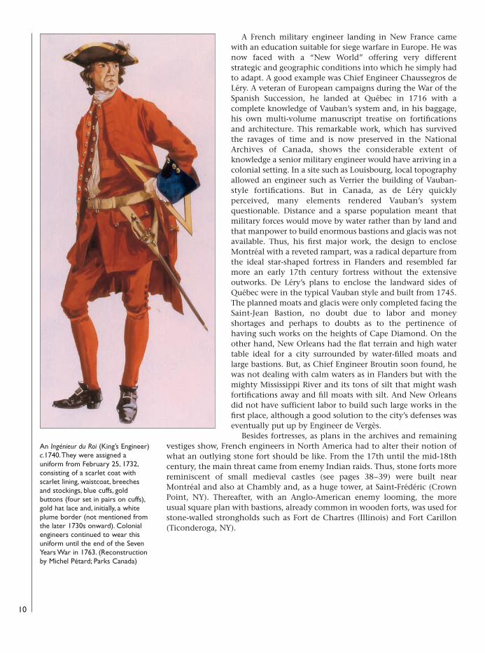
An Ingénieur du Roi (King’s Engineer)c.1740. They were assigned auniform from February 25, 1732,consisting of a scarlet coat withscarlet lining, waistcoat, breechesand stockings, blue cuffs, goldbuttons (four set in pairs on cuffs),gold hat lace and, initially, a whiteplume border (not mentioned fromthe later 1730s onward). Colonialengineers continued to wear thisuniform until the end of the SevenYears War in 1763. (Reconstructionby Michel Pétard; Parks Canada)
08098 FOR27corre.qxd:08098 FOR27corre.qxd 16/3/09 10:37 Page 10
The mightiest site on the continentThe most formidable fortress in North America was the city of Québec. AnIndian town was already there when, in 1535, French explorer Jacques Cartierarrived and named its imposing 300-foot cliff Cap Diamant (Cape Diamond).Cartier and his men decided to pass the winter in Canada. They feared“betrayal” on the part of the Indians and so they built a small fort “entirelyenclosed with large pieces of wood standing on end” that was mounted “withartillery all around it.” They reinforced it externally “with large moats, wideand deep, and a drawbridge gate.” It was the first fort built in Canada, but theFrench abandoned it the following year.
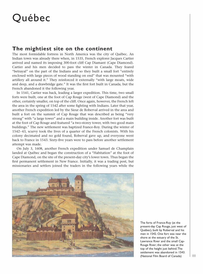
In 1541, Cartier was back, leading a larger expedition. This time, two smallforts were built, one at the foot of Cap Rouge (west of Cape Diamond) and theother, certainly smaller, on top of the cliff. Once again, however, the French leftthe area in the spring of 1542 after some fighting with Indians. Later that year,another French expedition led by the Sieur de Roberval arrived in the area andbuilt a fort on the summit of Cap Rouge that was described as being “verystrong” with “a large tower” and a main building inside. Another fort was builtat the foot of Cap Rouge and featured “a two-storey tower, with two good mainbuildings.” The new settlement was baptized France-Roy. During the winter of1542–43, scurvy took the lives of a quarter of the French colonists. With hiscolony decimated and no gold found, Roberval gave up, and everyone wentback to France in 1543. Sixty-five years were to pass before another settlementattempt was made.
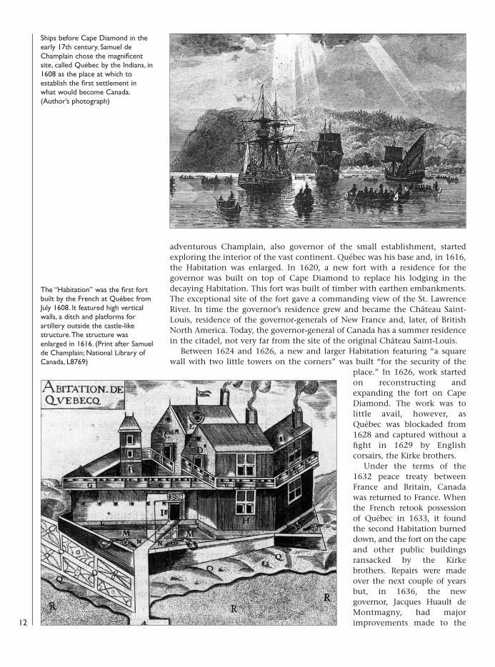
On July 3, 1608, another French expedition under Samuel de Champlainlanded at Québec and began the construction of a “Habitation” at the foot ofCape Diamond, on the site of the present-day city’s lower town. Thus began thefirst permanent settlement in New France. Initially, it was a trading post, butmissionaries and settlers joined the traders in the following years while the
11
Québec
The forts of France-Roy (at thepresent-day Cap Rouge, just west ofQuébec), built by Roberval and hismen in 1542. One fort was near theshore at the estuary of the St.Lawrence River and the small Cap-Rouge River; the other was at thetop of the height just behind. Thesettlement was abandoned in 1543.(National Film Board of Canada)
08098 FOR27corre.qxd:08098 FOR27corre.qxd 16/3/09 10:37 Page 11
adventurous Champlain, also governor of the small establishment, startedexploring the interior of the vast continent. Québec was his base and, in 1616,the Habitation was enlarged. In 1620, a new fort with a residence for thegovernor was built on top of Cape Diamond to replace his lodging in thedecaying Habitation. This fort was built of timber with earthen embankments.The exceptional site of the fort gave a commanding view of the St. LawrenceRiver. In time the governor’s residence grew and became the Château Saint-Louis, residence of the governor-generals of New France and, later, of BritishNorth America. Today, the governor-general of Canada has a summer residencein the citadel, not very far from the site of the original Château Saint-Louis.
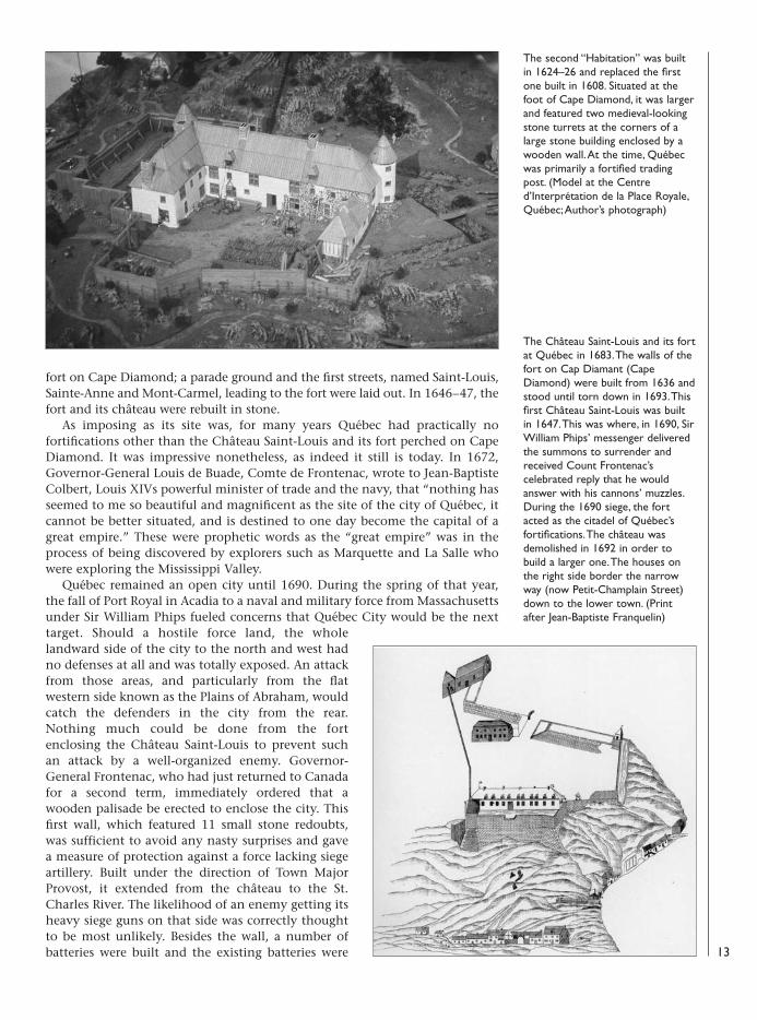
Between 1624 and 1626, a new and larger Habitation featuring “a squarewall with two little towers on the corners” was built “for the security of the
place.” In 1626, work startedon reconstructing andexpanding the fort on CapeDiamond. The work was tolittle avail, however, asQuébec was blockaded from1628 and captured without afight in 1629 by Englishcorsairs, the Kirke brothers.
Under the terms of the1632 peace treaty betweenFrance and Britain, Canadawas returned to France. Whenthe French retook possessionof Québec in 1633, it foundthe second Habitation burneddown, and the fort on the capeand other public buildingsransacked by the Kirkebrothers. Repairs were madeover the next couple of yearsbut, in 1636, the newgovernor, Jacques Huault deMontmagny, had majorimprovements made to the
Ships before Cape Diamond in theearly 17th century. Samuel deChamplain chose the magnificentsite, called Québec by the Indians, in1608 as the place at which toestablish the first settlement inwhat would become Canada.(Author’s photograph)
The “Habitation” was the first fortbuilt by the French at Québec fromJuly 1608. It featured high verticalwalls, a ditch and platforms forartillery outside the castle-likestructure. The structure wasenlarged in 1616. (Print after Samuelde Champlain; National Library ofCanada, L8769)
12
08098 FOR27corre.qxd:08098 FOR27corre.qxd 16/3/09 10:37 Page 12
fort on Cape Diamond; a parade ground and the first streets, named Saint-Louis,Sainte-Anne and Mont-Carmel, leading to the fort were laid out. In 1646–47, thefort and its château were rebuilt in stone.
As imposing as its site was, for many years Québec had practically nofortifications other than the Château Saint-Louis and its fort perched on CapeDiamond. It was impressive nonetheless, as indeed it still is today. In 1672,Governor-General Louis de Buade, Comte de Frontenac, wrote to Jean-BaptisteColbert, Louis XIVs powerful minister of trade and the navy, that “nothing hasseemed to me so beautiful and magnificent as the site of the city of Québec, itcannot be better situated, and is destined to one day become the capital of agreat empire.” These were prophetic words as the “great empire” was in theprocess of being discovered by explorers such as Marquette and La Salle whowere exploring the Mississippi Valley.
Québec remained an open city until 1690. During the spring of that year,the fall of Port Royal in Acadia to a naval and military force from Massachusettsunder Sir William Phips fueled concerns that Québec City would be the nexttarget. Should a hostile force land, the wholelandward side of the city to the north and west hadno defenses at all and was totally exposed. An attackfrom those areas, and particularly from the flatwestern side known as the Plains of Abraham, wouldcatch the defenders in the city from the rear.Nothing much could be done from the fortenclosing the Château Saint-Louis to prevent suchan attack by a well-organized enemy. Governor-General Frontenac, who had just returned to Canadafor a second term, immediately ordered that awooden palisade be erected to enclose the city. Thisfirst wall, which featured 11 small stone redoubts,was sufficient to avoid any nasty surprises and gavea measure of protection against a force lacking siegeartillery. Built under the direction of Town MajorProvost, it extended from the château to the St.Charles River. The likelihood of an enemy getting itsheavy siege guns on that side was correctly thoughtto be most unlikely. Besides the wall, a number ofbatteries were built and the existing batteries were
The second “Habitation” was builtin 1624–26 and replaced the firstone built in 1608. Situated at thefoot of Cape Diamond, it was largerand featured two medieval-lookingstone turrets at the corners of alarge stone building enclosed by awooden wall. At the time, Québecwas primarily a fortified tradingpost. (Model at the Centred’Interprétation de la Place Royale,Québec; Author’s photograph)
The Château Saint-Louis and its fortat Québec in 1683. The walls of thefort on Cap Diamant (CapeDiamond) were built from 1636 andstood until torn down in 1693. Thisfirst Château Saint-Louis was builtin 1647. This was where, in 1690, SirWilliam Phips’ messenger deliveredthe summons to surrender andreceived Count Frontenac’scelebrated reply that he wouldanswer with his cannons’ muzzles.During the 1690 siege, the fortacted as the citadel of Québec’sfortifications. The château wasdemolished in 1692 in order tobuild a larger one. The houses onthe right side border the narrowway (now Petit-Champlain Street)down to the lower town. (Printafter Jean-Baptiste Franquelin)
13
08098 FOR27corre.qxd:08098 FOR27corre.qxd 16/3/09 10:37 Page 13
14
1
2
3
45
6
7
8
910
11
12
1315
14
08098 FOR27corre.qxd:08098 FOR27corre.qxd 16/3/09 10:37 Page 14

improved. A battery of eight guns was erected next to the château and twomore were built at the docks in the lower town, each having three 18-poundercannons. Other batteries were sited at various points overlooking the river.All these batteries were meant to cover any enemy ship that got too close tothe city.
The 1690 siegeWhile Québec did not have a real citadel, the construction of all these batteriessited on the finest spots of the city’s commanding cape made it a difficult placefor enemy ships to attack. On October 16, 1690, some 34 ships flying Englishensigns came into view with 2,300 men on board. It was Sir William Phips,heading an expedition of New Englanders out to conquer New France. Thecolony of Massachusetts had sponsored the whole scheme and financed it by 15
Québec , 1690In 1690, the city of Québec did not have extensive fortifications. Instead it relied on the great strengths offered by itslocation. Not only did the city have outstanding and very visible cliffs and Cape Diamond, but also its whole eastern shoreheading toward the St. Charles River to the north was very shallow and could not be approached by ships. The town’smain man-made defenses consisted of batteries set up in both the lower town and upon the cliff, and a palisade toprotect the landward side. Within the city, various temporary obstacles had also been erected, notably at the streetleading to the upper town.
In the upper town, just west of the fort (1) and the Château Saint-Louis, residence of the governor-general, was an eight-gun battery (2). East of the Château Saint-Louis, at the turn of the cliff toward the north, was a three-gun battery (3).
On the shore of the lower town, at the site of the future Royal Battery, was a platform with three 18-pounder guns(4). Further east on the waterfront was another battery with three 18-pounder guns (5). Heading north, at the limit ofthe town near the intendant’s palace, was another three-gun battery at water level (6). This area also had a largecontingent of troops and, beyond, the west shore of the St. Charles River had been strenghened with field fortifications(not shown).
The landward side was enclosed by a palisade built shortly before the siege (7). It started west of the battery near theChâteau Saint-Louis and ended on the eastern side not very far from the hospital. This log wall featured 11 stone“redoubts” that seem to have been square towers. On the west side, facing the Plains of Abraham, was a windmill calledMont-Carmel where a three-gun battery was established to provide a strong point for the palisade line on the landwardside (8). There may also have been individual guns at other locations all over the city.. Other important sites in the cityincluded the Bishop's palace (9),. Québec Seminary (10), Jesuit's College and residence (11), Hospital (12), Ursuline SistersCollege and residence (13), Saint-Louis Gate (14) and Saint-Jean Gate (15).
This bust of Louis XIV by Berniniwas unveiled in 1686 at the PlaceRoyale in Québec’s lower town.Later removed and lost, anothercasting of the bust was installedwhen the area was renovated in the1960s and 1970s; a fitting reminderof the “Sun King” whose policiesfostered France’s influence in NorthAmerica. (Author’s photograph)
08098 FOR27corre.qxd:08098 FOR27corre.qxd 16/3/09 10:37 Page 15
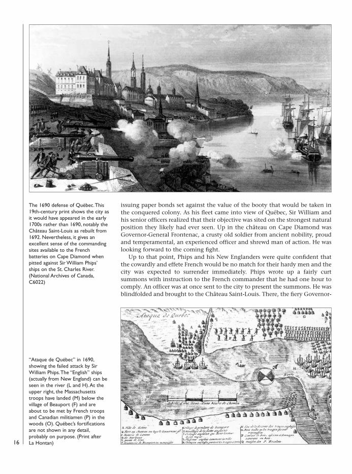
issuing paper bonds set against the value of the booty that would be taken inthe conquered colony. As his fleet came into view of Québec, Sir William andhis senior officers realized that their objective was sited on the strongest naturalposition they likely had ever seen. Up in the château on Cape Diamond wasGovernor-General Frontenac, a crusty old soldier from ancient nobility, proudand temperamental, an experienced officer and shrewd man of action. He waslooking forward to the coming fight.
Up to that point, Phips and his New Englanders were quite confident thatthe cowardly and effete French would be no match for their hardy men and thecity was expected to surrender immediately. Phips wrote up a fairly curtsummons with instruction to the French commander that he had one hour tocomply. An officer was at once sent to the city to present the summons. He wasblindfolded and brought to the Château Saint-Louis. There, the fiery Governor-
16
The 1690 defense of Québec. This19th-century print shows the city asit would have appeared in the early1700s rather than 1690, notably theChâteau Saint-Louis as rebuilt from1692. Nevertheless, it gives anexcellent sense of the commandingsites available to the Frenchbatteries on Cape Diamond whenpitted against Sir William Phips’ships on the St. Charles River.(National Archives of Canada,C6022)
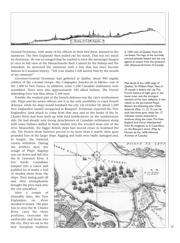
“Ataque de Québec” in 1690,showing the failed attack by SirWilliam Phips. The “English” ships(actually from New England) can beseen in the river (L and H). At theupper right, the Massachusettstroops have landed (M) below thevillage of Beauport (F) and areabout to be met by French troopsand Canadian militiamen (P) in thewoods (O). Québec’s fortificationsare not shown in any detail,probably on purpose. (Print afterLa Hontan)
08098 FOR27corre.qxd:08098 FOR27corre.qxd 16/3/09 10:37 Page 16
General Frontenac, with many of his officers in their best dress, listened to thesummons. The New Englander then pulled out his watch. That was too muchfor Frontenac. He was so enraged that he wanted to have the messenger hangedat once in full view of the Massachusetts fleet! Calmed by the bishop and theintendant, he answered the summons with a line that has since becomefamous in Canadian history: “Tell your master I will answer him by the mouthof my cannons!”
Governor-General Frontenac had gathered at Québec about 900 regularsoldiers of the colonial troops—the Compagnies franches de la Marine—out ofthe 1,400 in New France. In addition, some 1,100 Canadian militiamen wereassembled. There were also approximately 100 allied Indians. The Frenchdefending force was thus about 2,100 men.
Possibly the weakest part of the French defenses was the city’s northeasternside. Phips and his senior officers saw it as the only possibility to crack Frenchdefenses, while his ships would bombard the city. On October 18, about 1,200New Englanders landed unopposed at Beauport. Frontenac expected the NewEnglanders’ land attack to come from that area and so the banks of the St.Charles River had been built up with field fortifications on the southwesternside. He had already sent strong detachments of Canadian militiamen alongwith some Indians skilled in bush warfare into the wooded areas east of theriver. Meanwhile, the bigger British ships had moved closer to bombard thecity. The French shore batteries proved to be more than a match; their gunspounded four of the larger ships. Rigging and hulls were badly damaged and,at length, the batteredvessels withdrew. Duringthe artillery duel, theensign of Phips’ flagshipwas cut down and fell intothe St. Lawrence River. Afew hardy Canadiansjumped into a canoe andpaddled for it under a hailof musket shots from theships. Their daring paid offand they triumphantlybrought the prize back intothe city unscathed.
After a couple ofmiserable days, the NewEnglanders on shoredecided to attack. The planwas to cross the St. CharlesRiver, carry the shorepositions, overcome theearthworks and break intothe city. They set out in thebest European tradition
A 1690 view of Québec from thenortheast. The logs of the hurriedlyerected palisade helped seal the cityagainst an attack from the landwardside. (National Archives of Canada)
Map detail of the 1690 siege ofQuébec. Sir William Phips’ fleet of34 vessels is before the city. TheFrench battery of eight guns in thelower town was the strongestelement of the city’s defenses. It wasrebuilt as the permanent RoyalBattery the following year. Otherbatteries (Nos. 11, 12, 15 and 16)each had three guns, while No. 17indicates canoes stationed aslookouts along the coast. The NewEngland land forces disembarkedfrom 42 longboats at la Canardière,on the Beauport shore. (Map byNicolas de Fer, 1694; NationalArchives of Canada)
17
08098 FOR27corre.qxd:08098 FOR27corre.qxd 16/3/09 10:37 Page 17
Qué
bec:
T
he R
oyal
Bat
tery
T
his
batt
ery
was
situ
ated
on
the
wat
erfr
ont
of t
helo
wer
tow
n an
d, in
spi
te o
f bei
ng r
elat
ivel
y m
odes
tin
siz
e, w
as o
ne o
f the
mos
t im
port
ant
fort
ifica
tions
in t
he c
ity d
ue t
o its
str
ateg
ic lo
catio
n. T
he R
oyal
Batt
ery’s
gun
s co
vere
d th
e ci
ty’s
dock
are
a an
d a
good
par
t of
the
St.
Law
renc
e R
iver
to
its s
outh
shor
e.
Aft
er t
he s
iege
of 1
690,
Gov
erno
r-G
ener
alFr
onte
nac
orde
red
a fu
lly fl
edge
d sh
ore
batt
ery
tobe
bui
lt th
ere.
It w
as s
hape
d lik
e a
smal
l bas
tion
and
f eat
ured
14
embr
asur
es fo
r gu
ns t
o co
ver
both
sid
es o
f the
sho
re a
s w
ell a
s th
e ri
ver.
Ove
rth
e ye
ars,
som
e fe
atur
es c
hang
ed, n
otab
ly t
henu
mbe
r of
em
bras
ures
for
guns
; the
y w
ere
redu
ced
to 1
1 in
169
5 to
acco
mm
odat
e 24
-pou
nder
and
18-
poun
der
can
nons
. Thi
s re
mai
ned
the
case
unt
il an
othe
rem
bras
ure
was
elim
inat
edbe
twee
n 17
42 a
nd 1
755.
In17
55, t
he b
atte
ry h
ad t
wo
24-p
ound
ers,
one
18-
poun
der
and
seve
n8-
poun
ders
. Thi
s ap
pear
sto
hav
e be
en c
hang
edth
e fo
llow
ing
year
to
four
24-
poun
ders
, tw
o18
-pou
nder
s an
d fo
ur12
-pou
nder
s. Fi
nally
,so
met
ime
befo
re t
he17
59 s
iege
, ten
36-
poun
ders
wer
e re
ceiv
edfr
om F
ranc
e an
d so
me
ofth
ese
heav
y-ca
liber
can
nons
wer
e in
stal
led
in t
he b
atte
ry.
Dur
ing
the
sieg
e, t
he R
oyal
Batt
ery
was
the
sce
ne o
foc
casi
onal
art
iller
y du
els
with
Briti
sh s
hips
, but
it w
as w
ithin
ran
geof
the
pow
erfu
l Bri
tish
batt
erie
s bu
iltat
Lev
is, o
n th
e so
uth
shor
e. T
hese
prov
ed s
uper
ior,
espe
cial
ly a
s th
e lo
w-
lyin
g R
oyal
Bat
tery
cou
ld n
ot r
etur
n fir
eem
anat
ing
from
the
Lév
is c
liffs
.C
onse
quen
tly, b
y Se
ptem
ber
1759
it h
adbe
en h
alf-d
estr
oyed
, lik
e th
e re
st o
f the
low
er t
own.
Aft
er t
he S
even
Yea
rs W
ar(1
756–
63),
the
site
of t
he b
atte
ry w
astr
ansf
orm
ed in
to t
rade
doc
ks c
over
ed w
ithw
areh
ouse
s. Bu
t th
e ol
d ba
tter
y w
as n
ever
qui
tefo
rgot
ten
and,
in t
he 1
970s
, was
res
tore
d to
its
mid
-18t
h-ce
ntur
y ap
pear
ance
by
the
Qué
bec
gove
rnm
ent.
18
08098 FOR27corre.qxd:08098 FOR27corre.qxd 16/3/09 10:37 Page 18
with drums beating and colors unfurled. At the edges of the woods, plenty ofCanadian militiamen were waiting for them. The New England militiamencould not cope with their heavy fire, wavered and fell back. Brass field gunswere brought up and fired into the woods, but to no effect. At length, unableto advance further, the New Englanders retreated back to their camp. TheCanadians and Indians maintained the pressure thereafter by skirmishingcloser and closer to their camp. By the night of October 21–22, the NewEnglanders were utterly discouraged and made a spontaneous general retreat totheir ships in a state of near panic, even leaving behind five of their field gunson the shore. Thus far, about 150 New Englanders had been killed or woundedin action and many more would die of exposure and sickness. The French andCanadians had suffered, at most, nine killed and 52 wounded (but only eightknown wounded for certain). On October 23, Phips and his fleet sailed back toBoston. Thus ended the first siege of Québec.
The old and new fortifications, essentially the batteries, had proven morethan a match for Phips’ ships when they tried to bombard the city. Thebatteries on the waterfront had not been seriously damaged while those furtherup were unscathed. The weak pointhad been the Beauport shore wherethe New Englanders had landed; butthey had been contained and drivenback. However, if a stronger forcelanded there with siege artillery, thecity could be attacked on thelandward side. Obviously, the hastilybuilt wall would have to beimproved. For the New Englanders, amost important lesson had beenlearned: they could not, bythemselves, take Québec; to achievesuch an objective, the resources ofOld England would have to bebrought in.
ImprovementsAlthough the attack had beenrepulsed, Governor-General Frontenacwas well aware of Québec’s weaknesses
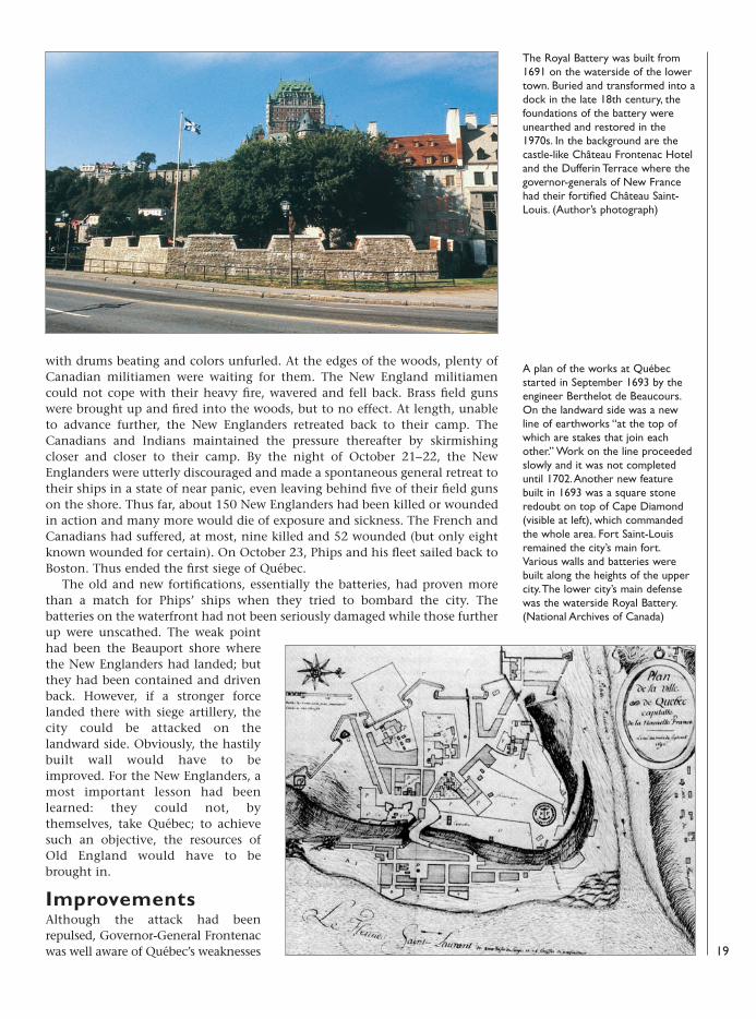
The Royal Battery was built from1691 on the waterside of the lowertown. Buried and transformed into adock in the late 18th century, thefoundations of the battery wereunearthed and restored in the1970s. In the background are thecastle-like Château Frontenac Hoteland the Dufferin Terrace where thegovernor-generals of New Francehad their fortified Château Saint-Louis. (Author’s photograph)
A plan of the works at Québecstarted in September 1693 by theengineer Berthelot de Beaucours.On the landward side was a newline of earthworks “at the top ofwhich are stakes that join eachother.” Work on the line proceededslowly and it was not completeduntil 1702. Another new featurebuilt in 1693 was a square stoneredoubt on top of Cape Diamond(visible at left), which commandedthe whole area. Fort Saint-Louisremained the city’s main fort.Various walls and batteries werebuilt along the heights of the uppercity. The lower city’s main defensewas the waterside Royal Battery.(National Archives of Canada)
19
08098 FOR27corre.qxd:08098 FOR27corre.qxd 16/3/09 10:38 Page 19
and, in 1692, tasked Engineer Josué Berthelot de Beaucours with the design andconstruction of new fortifications on the landward side that could withstand aEuropean-style siege. Work started in the summer of 1693 on an earth rampartwith large bastions, which enclosed the city. Pointed wooden stakes were plantedon top of the walls. Two masonry structures were also built: the Cape DiamondRedoubt on top of the highest spot on the cape and the cavalier du Moulin in thefirst bastion. The building work continued slowly for nine years. In the meantime,a new engineer, Jacques Levasseur de Néré, had arrived and disagreed with justabout everything de Beaucours had constructed. The new fortifications did indeedhave some defects; most could be enfiladed from various heights outside thefortifications. The resulting disputes put a stop to any major works for some timeto come.
In 1711, during Queen Anne’s War (1702–13), another attempt was made tocapture Québec. This time, Royal Navy Admiral Hoveden Walker sailed for
20
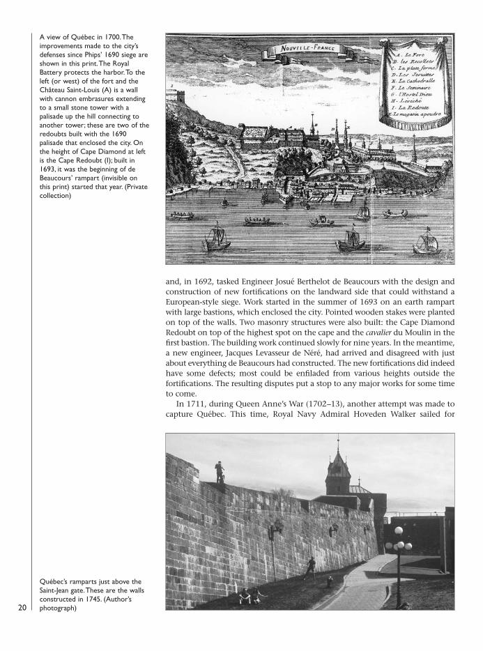
A view of Québec in 1700. Theimprovements made to the city’sdefenses since Phips’ 1690 siege areshown in this print. The RoyalBattery protects the harbor. To theleft (or west) of the fort and theChâteau Saint-Louis (A) is a wallwith cannon embrasures extendingto a small stone tower with apalisade up the hill connecting toanother tower; these are two of theredoubts built with the 1690palisade that enclosed the city. Onthe height of Cape Diamond at leftis the Cape Redoubt (I); built in1693, it was the beginning of deBeaucours’ rampart (invisible onthis print) started that year. (Privatecollection)
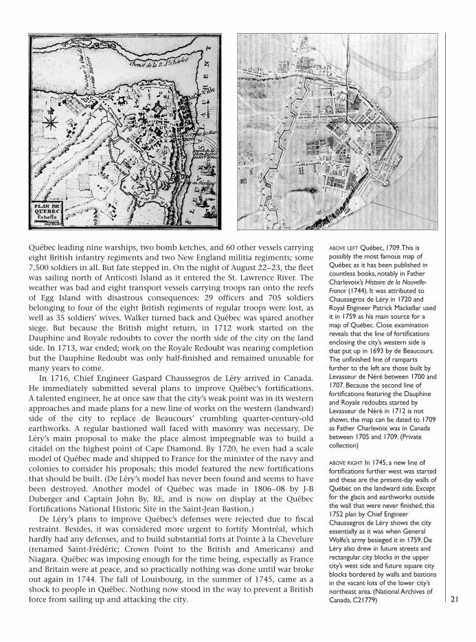
Québec’s ramparts just above theSaint-Jean gate. These are the wallsconstructed in 1745. (Author’sphotograph)
08098 FOR27corre.qxd:08098 FOR27corre.qxd 16/3/09 10:38 Page 20
Québec leading nine warships, two bomb ketches, and 60 other vessels carryingeight British infantry regiments and two New England militia regiments; some7,500 soldiers in all. But fate stepped in. On the night of August 22–23, the fleetwas sailing north of Anticosti Island as it entered the St. Lawrence River. Theweather was bad and eight transport vessels carrying troops ran onto the reefsof Egg Island with disastrous consequences: 29 officers and 705 soldiersbelonging to four of the eight British regiments of regular troops were lost, aswell as 35 soldiers’ wives. Walker turned back and Québec was spared anothersiege. But because the British might return, in 1712 work started on theDauphine and Royale redoubts to cover the north side of the city on the landside. In 1713, war ended; work on the Royale Redoubt was nearing completionbut the Dauphine Redoubt was only half-finished and remained unusable formany years to come.
In 1716, Chief Engineer Gaspard Chaussegros de Léry arrived in Canada.He immediately submitted several plans to improve Québec’s fortifications.A talented engineer, he at once saw that the city’s weak point was in its westernapproaches and made plans for a new line of works on the western (landward)side of the city to replace de Beaucours’ crumbling quarter-century-oldearthworks. A regular bastioned wall faced with masonry was necessary. DeLéry’s main proposal to make the place almost impregnable was to build acitadel on the highest point of Cape Diamond. By 1720, he even had a scalemodel of Québec made and shipped to France for the minister of the navy andcolonies to consider his proposals; this model featured the new fortificationsthat should be built. (De Léry’s model has never been found and seems to havebeen destroyed. Another model of Québec was made in 1806–08 by J-BDuberger and Captain John By, RE, and is now on display at the QuébecFortifications National Historic Site in the Saint-Jean Bastion.)
De Léry’s plans to improve Québec’s defenses were rejected due to fiscalrestraint. Besides, it was considered more urgent to fortify Montréal, whichhardly had any defenses, and to build substantial forts at Pointe à la Chevelure(renamed Saint-Frédéric; Crown Point to the British and Americans) andNiagara. Québec was imposing enough for the time being, especially as Franceand Britain were at peace, and so practically nothing was done until war brokeout again in 1744. The fall of Louisbourg, in the summer of 1745, came as ashock to people in Québec. Nothing now stood in the way to prevent a Britishforce from sailing up and attacking the city. 21
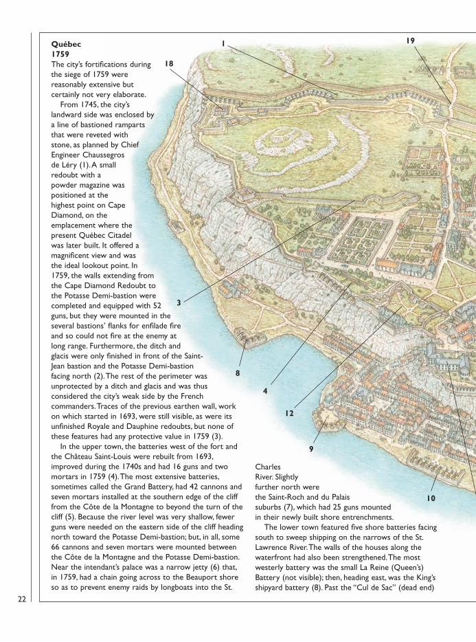
ABOVE LEFT Québec, 1709. This ispossibly the most famous map ofQuébec as it has been published incountless books, notably in FatherCharlevoix’s Histoire de la Nouvelle-France (1744). It was attributed toChaussegros de Léry in 1720 andRoyal Engineer Patrick Mackellar usedit in 1759 as his main source for amap of Québec. Close examinationreveals that the line of fortificationsenclosing the city’s western side isthat put up in 1693 by de Beaucours.The unfinished line of rampartsfurther to the left are those built byLevasseur de Néré between 1700 and1707. Because the second line offortifications featuring the Dauphineand Royale redoubts started byLevasseur de Néré in 1712 is notshown, the map can be dated to 1709as Father Charlevoix was in Canadabetween 1705 and 1709. (Privatecollection)
ABOVE RIGHT In 1745, a new line offortifications further west was startedand these are the present-day walls ofQuébec on the landward side. Exceptfor the glacis and earthworks outsidethe wall that were never finished, this1752 plan by Chief EngineerChaussegros de Léry shows the cityessentially as it was when GeneralWolfe’s army besieged it in 1759. DeLéry also drew in future streets andrectangular city blocks in the uppercity’s west side and future square cityblocks bordered by walls and bastionsin the vacant lots of the lower city’snortheast area. (National Archives ofCanada, C21779)
08098 FOR27corre.qxd:08098 FOR27corre.qxd 16/3/09 10:38 Page 21
Québec1759 The city’s fortifications duringthe siege of 1759 werereasonably extensive butcertainly not very elaborate.
From 1745, the city’slandward side was enclosed bya line of bastioned rampartsthat were reveted withstone, as planned by ChiefEngineer Chaussegrosde Léry (1). A smallredoubt with apowder magazine waspositioned at thehighest point on CapeDiamond, on theemplacement where thepresent Québec Citadelwas later built. It offered amagnificent view and wasthe ideal lookout point. In1759, the walls extending fromthe Cape Diamond Redoubt tothe Potasse Demi-bastion werecompleted and equipped with 52guns, but they were mounted in theseveral bastions’ flanks for enfilade fireand so could not fire at the enemy atlong range. Furthermore, the ditch andglacis were only finished in front of the Saint-Jean bastion and the Potasse Demi-bastionfacing north (2). The rest of the perimeter wasunprotected by a ditch and glacis and was thusconsidered the city’s weak side by the Frenchcommanders. Traces of the previous earthen wall, workon which started in 1693, were still visible, as were itsunfinished Royale and Dauphine redoubts, but none ofthese features had any protective value in 1759 (3).
In the upper town, the batteries west of the fort andthe Château Saint-Louis were rebuilt from 1693,improved during the 1740s and had 16 guns and twomortars in 1759 (4). The most extensive batteries,sometimes called the Grand Battery, had 42 cannons andseven mortars installed at the southern edge of the clifffrom the Côte de la Montagne to beyond the turn of thecliff (5). Because the river level was very shallow, fewerguns were needed on the eastern side of the cliff headingnorth toward the Potasse Demi-bastion; but, in all, some66 cannons and seven mortars were mounted betweenthe Côte de la Montagne and the Potasse Demi-bastion.Near the intendant’s palace was a narrow jetty (6) that,in 1759, had a chain going across to the Beauport shoreso as to prevent enemy raids by longboats into the St.
CharlesRiver. Slightlyfurther north werethe Saint-Roch and du Palaissuburbs (7), which had 25 guns mountedin their newly built shore entrenchments.
The lower town featured five shore batteries facingsouth to sweep shipping on the narrows of the St.Lawrence River. The walls of the houses along thewaterfront had also been strengthened. The mostwesterly battery was the small La Reine (Queen’s)Battery (not visible); then, heading east, was the King’sshipyard battery (8). Past the “Cul de Sac” (dead end)
22
12
1
3
4
8
9
10
13
19
18
08098 FOR27corre.qxd:08098 FOR27corre.qxd 16/3/09 10:38 Page 22
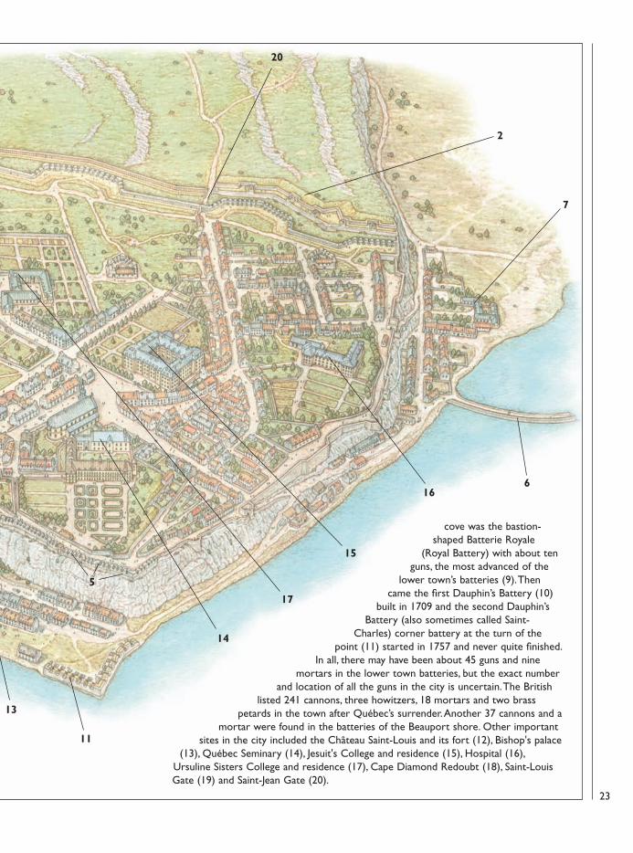
cove was the bastion-shaped Batterie Royale
(Royal Battery) with about tenguns, the most advanced of the
lower town’s batteries (9). Thencame the first Dauphin’s Battery (10)
built in 1709 and the second Dauphin’sBattery (also sometimes called Saint-
Charles) corner battery at the turn of thepoint (11) started in 1757 and never quite finished.
In all, there may have been about 45 guns and ninemortars in the lower town batteries, but the exact number
and location of all the guns in the city is uncertain. The Britishlisted 241 cannons, three howitzers, 18 mortars and two brass
petards in the town after Québec’s surrender. Another 37 cannons and amortar were found in the batteries of the Beauport shore. Other important
sites in the city included the Château Saint-Louis and its fort (12), Bishop's palace(13), Québec Seminary (14), Jesuit's College and residence (15), Hospital (16),
Ursuline Sisters College and residence (17), Cape Diamond Redoubt (18), Saint-LouisGate (19) and Saint-Jean Gate (20).
23
2
20
5
6
7
11
13
14
16
15
17
08098 FOR27corre.qxd:08098 FOR27corre.qxd 16/3/09 10:38 Page 23
Improving Québec’s fortifications became the order of the day. De Léry’splans called for the construction of a classic Vauban-style wall with four largebastions and a demi-bastion at each end. The bastions provided for one ofVauban’s basic principles in defensive works: the protection of the ditch bycrossfire from the flanks of the bastions. By the fall of 1745, hundreds of menwere busy constructing the ramparts. The contractor hired specializedcraftsmen and their apprentices as well as some soldiers familiar with buildingtrades, but they were much too few in number. To obtain the necessarymanpower, the government decreed a corvée—compulsory labor for a publicwork—on every able-bodied man aged from 16 to 60 within a radius of 40French miles to help construct the rampart. They put up the masonry stonewall with buttresses and filled the inside with earth to make up the rampart.Just outside the wall, a ditch with a glacis was planned but only a small portionof it was built, in front of the Saint-Jean Bastion.
In 1748, de Léry completed the unfinished Dauphine Redoubt originallydesigned by de Beaucours as an arms and ammunition storehouse. Thefollowing year, it was transformed into a barrack. Close by, the NouvelleCasernes (New Barracks) were built from 1749 to 1752 to house the garrison. Itwas an imposing structure and, at over 520 feet from end to end, the longestbuilding in North America at that time.
The 1759 siegeThe Austrian Succession War ended in 1748 but another conflict was expectedand, in 1754, it broke out in the wilderness of the Ohio Valley. By 1756, warhad been formally declared between France, Britain and most other majorEuropean nations. Governor-General Vaudreuil worried about Québec’sdefenses and, in October 1756, noted that little had been done since the 1740sto improve the ramparts. Vaudreuil tasked the Engineer Nicolas Sarrebrousse dePontleroy, transferred from Louisbourg to Québec, with improving the city’sfortifications. The batteries of La Genouillère and du Clergé were built and a 6-foot-wide wall was started but left unfinished on the upper east side near theSt. Charles River. In America, the British and Americans slowly gained theadvantage over the French, thanks to their greatly superior forces. WhenLouisbourg fell in July 1758, it opened the way to Québec. It was now obviousthat the city would be the next target.
Pontleroy, as well as many Frencharmy officers sent to Canada, hadlittle confidence in the ramparts putup since 1745. As Louis-Antoine deBougainville, General Montcalm’saide-de-camp, put it, Québec “waswithout fortifications” and would bedifficult to fortify, adding, “if theapproaches to the city were notdefended, the place would have tosurrender.” General Montcalmthought much the same, as didPontleroy. Perhaps their judgementon de Léry’s ramparts was somewhathasty but they saw it as anunfinished piece of work withoutditches and glacis. By the standardsof the day, the walls would thus havebeen easily breached by enemy siegeartillery. It was therefore essential todeny the enemy a foothold on thenorth shore of the St. Lawrence
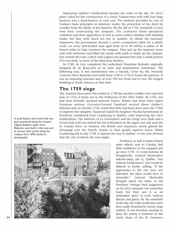
A small battery still armed with twoguns positioned along the rampartedging Québec’s upper town.Batteries were built in that area andat various other points along thisrampart from 1690. (Author’sphotograph)
24
08098 FOR27corre.qxd:08098 FOR27corre.qxd 16/3/09 10:38 Page 24
River. If such a thing occurred, it wasexpected that the British, with theirsuperior resources and greater numbers ofregular soldiers, would prevail and the citywould be doomed. It was therefore essentialto build redans and batteries along thewhole length of the north shore, from theMontmorency River to the city. Buteverything else also had to be improved. Itwas a tall order.
By the spring of 1759, an attack on thecity was daily expected and so the defenseswere in the process of being strengthened.Thousands of men were employed buildingnew fortifications and improving old onesall over the city. A strong barricade closedthe Côte de la Montagne road to the uppercity. The suburbs of Saint-Roch and duPalais were enclosed and armed with 25cannons. Some 66 cannons and sevenmortars were installed between the Côte dela Montagne and the Potasse Bastion andanother 52 cannons were installed on thewestern side. Between the Château Saint-Louis and the Cape Diamond Redoubt,another two batteries holding 16 cannons and two mortars were built.
Perhaps the most impressive effort was to fortify the length of the Beauportshore, from the falls of the Montmorency River, which would act as the eastern(or left) side of the French army. Pontleroy felt that it was the weak point,especially in the area about La Canardière where Phips’ men had landed in 1690.A first entrenchment line was built in May running along the St. Charles River upto the General Hospital. Pontleroy wanted to close access to the river and had twoships scuttled at its entrance. They were transformed into advanced batteries.Behind were more obstacles including a boat bridge and a floating battery calledLa Diable (The She-Devil) holding 18 cannons of 24-pound caliber. By the end ofJune 1759, many batteries, redoubts and redans had been built along theBeauport shore, both on the cliff and on the beach, some mounted with guns.General Montcalm listed the following on 27 June:
25
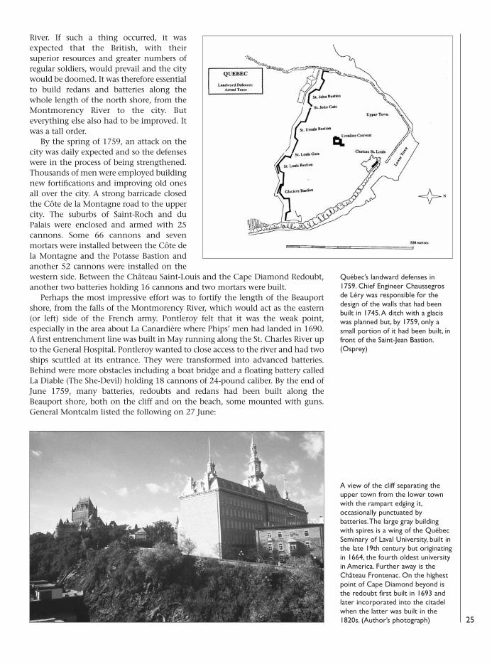
Québec’s landward defenses in1759. Chief Engineer Chaussegrosde Léry was responsible for thedesign of the walls that had beenbuilt in 1745. A ditch with a glaciswas planned but, by 1759, only asmall portion of it had been built, infront of the Saint-Jean Bastion.(Osprey)
A view of the cliff separating theupper town from the lower townwith the rampart edging it,occasionally punctuated bybatteries. The large gray buildingwith spires is a wing of the QuébecSeminary of Laval University, built inthe late 19th century but originatingin 1664, the fourth oldest universityin America. Further away is theChâteau Frontenac. On the highestpoint of Cape Diamond beyond isthe redoubt first built in 1693 andlater incorporated into the citadelwhen the latter was built in the1820s. (Author’s photograph)
08098 FOR27corre.qxd:08098 FOR27corre.qxd 16/3/09 10:38 Page 25
Pointe-à-Roussel Battery: three 12-pounder cannons, flanked by two redans La Canardière Battery: three 12-poundersMorille RedanChalifour RedanVienne RedanVieux camp Redan: three 8-poundersDes Tours RedanParauts Redan: three 8-poundersRedoubt of the mouth of the Beauport RiverChesnay RedanSalaberry RedanRedoubt below the church with two batteries: four 12-poundersSaint-Louis Battery with two redans to be builtSault Redoubt: three 8-pounders
The Sault Redoubt was the most easterly on the beach, just below the majestic-looking Montmorency falls. Another work, the Johnstone Battery, was also built
on the beach, about 900 yardswest of the Sault Redoubt.Behind all these works was agarrison of about 15,000troops, mostly militiamen.
In late June, the anticipatedinvasion force came into sightas an enormous fleet made itsway on the St. Lawrence River.On board were some 10,000regular soldiers and 13,000sailors with a powerful train ofartillery. In the followingmonths, part of the lowertown was destroyed by theconstant British bombard-ments. However, that area wasconsidered much too strong aposition to attack. Both theshore batteries and the ones
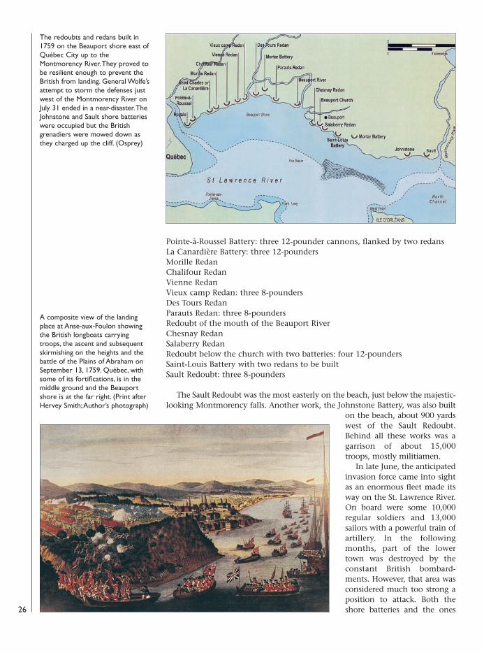
The redoubts and redans built in1759 on the Beauport shore east ofQuébec City up to theMontmorency River. They proved tobe resilient enough to prevent theBritish from landing. General Wolfe’sattempt to storm the defenses justwest of the Montmorency River onJuly 31 ended in a near-disaster. TheJohnstone and Sault shore batterieswere occupied but the Britishgrenadiers were mowed down asthey charged up the cliff. (Osprey)
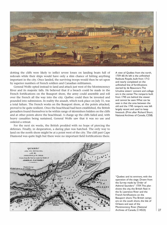
A composite view of the landingplace at Anse-aux-Foulon showingthe British longboats carryingtroops, the ascent and subsequentskirmishing on the heights and thebattle of the Plains of Abraham onSeptember 13, 1759. Québec, withsome of its fortifications, is in themiddle ground and the Beauportshore is at the far right. (Print afterHervey Smith; Author’s photograph)
26
08098 FOR27corre.qxd:08098 FOR27corre.qxd 16/3/09 10:38 Page 26
dotting the cliffs were likely to inflict severe losses on landing boats full ofredcoats while their ships would have only a slim chance of hitting anythingimportant in the city. Once landed, the surviving troops would then be set uponby superior numbers of French soldiers and Canadian militiamen.
General Wolfe opted instead to land and attack just west of the MontmorencyRiver and its majestic falls. He believed that if a breach could be made in theFrench fortifications on the Beauport shore, the army could assemble and rollover the French all the way into the city. Québec could then be invested andpounded into submission. In reality the assault, which took place on July 31, wasa total failure. The French works on the Beauport shore, at the points attacked,proved to be quite resilient. Once the beachhead had been established, the Britishgrenadiers found themselves to be within range of skirmishers hidden on the cliffsand at other points above the beachhead. A charge up the cliffs failed and, withheavy casualties being sustained, General Wolfe saw that it was no use andordered a retreat.
For the next six weeks, the British prodded with no hope of piercing thedefenses. Finally, in desperation, a daring plan was hatched. The only way toland on the north shore might be at a point west of the city. The cliff past CapeDiamond was quite high but there were no important field fortifications there.
27
A view of Québec from the north,1759–60. At left is the unfinishedRedoute Royale, built from 1712and nearly completed on theunfinished line of fortificationsstarted by de Beaucours. TheUrsuline sisters’ convent and collegeare in the center. The ramparts builtfrom 1745 are behind the viewerand cannot be seen. What can beseen is that the area between theold and the 1745 ramparts was leftlargely vacant and used to keeplivestock. (Print after Richard Short;National Archives of Canada, C358)
“Quebec and its environs, with theoperation of the siege. Drawn fromthe Survey made by Order ofAdmiral Saunders” 1759. This planshows the city, the British fleet inthe St. Lawrence River and theFrench fortifications on theBeauport shore. The British campsare on the south shore, the Isle ofOrleans and east of theMontmorency River. (NationalArchives of Canada, C14523)
08098 FOR27corre.qxd:08098 FOR27corre.qxd 16/3/09 10:38 Page 27
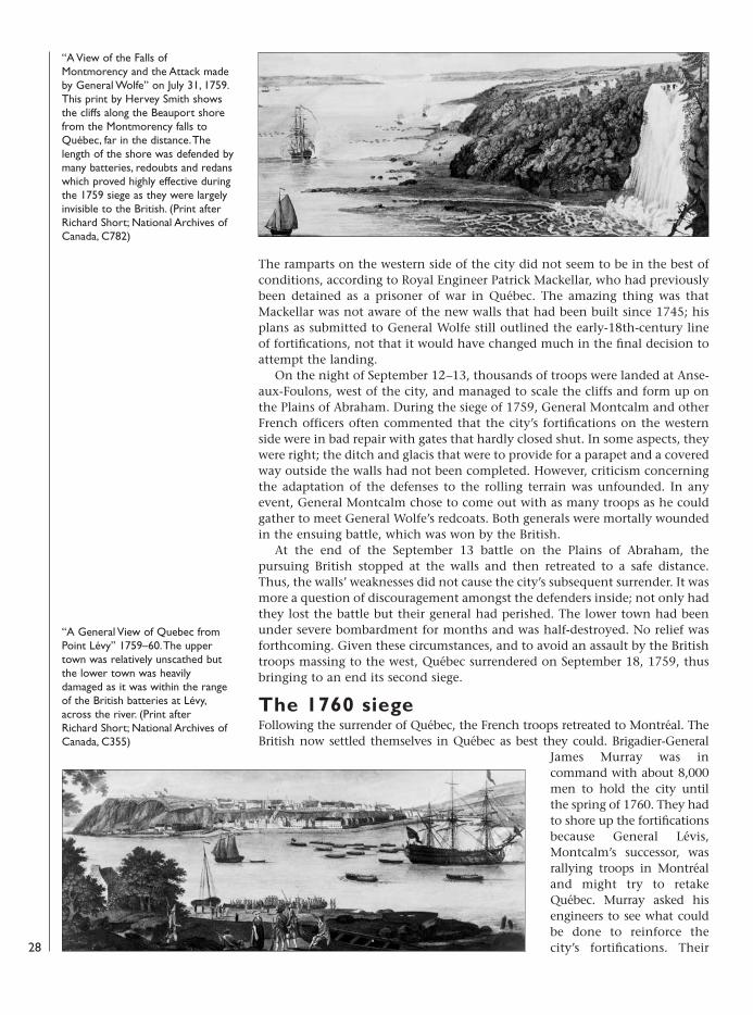
The ramparts on the western side of the city did not seem to be in the best ofconditions, according to Royal Engineer Patrick Mackellar, who had previouslybeen detained as a prisoner of war in Québec. The amazing thing was thatMackellar was not aware of the new walls that had been built since 1745; hisplans as submitted to General Wolfe still outlined the early-18th-century lineof fortifications, not that it would have changed much in the final decision toattempt the landing.
On the night of September 12–13, thousands of troops were landed at Anse-aux-Foulons, west of the city, and managed to scale the cliffs and form up onthe Plains of Abraham. During the siege of 1759, General Montcalm and otherFrench officers often commented that the city’s fortifications on the westernside were in bad repair with gates that hardly closed shut. In some aspects, theywere right; the ditch and glacis that were to provide for a parapet and a coveredway outside the walls had not been completed. However, criticism concerningthe adaptation of the defenses to the rolling terrain was unfounded. In anyevent, General Montcalm chose to come out with as many troops as he couldgather to meet General Wolfe’s redcoats. Both generals were mortally woundedin the ensuing battle, which was won by the British.
At the end of the September 13 battle on the Plains of Abraham, thepursuing British stopped at the walls and then retreated to a safe distance.Thus, the walls’ weaknesses did not cause the city’s subsequent surrender. It wasmore a question of discouragement amongst the defenders inside; not only hadthey lost the battle but their general had perished. The lower town had beenunder severe bombardment for months and was half-destroyed. No relief wasforthcoming. Given these circumstances, and to avoid an assault by the Britishtroops massing to the west, Québec surrendered on September 18, 1759, thusbringing to an end its second siege.
The 1760 siegeFollowing the surrender of Québec, the French troops retreated to Montréal. TheBritish now settled themselves in Québec as best they could. Brigadier-General
James Murray was incommand with about 8,000men to hold the city untilthe spring of 1760. They hadto shore up the fortificationsbecause General Lévis,Montcalm’s successor, wasrallying troops in Montréaland might try to retakeQuébec. Murray asked hisengineers to see what couldbe done to reinforce thecity’s fortifications. Their
“A View of the Falls ofMontmorency and the Attack madeby General Wolfe” on July 31, 1759.This print by Hervey Smith showsthe cliffs along the Beauport shorefrom the Montmorency falls toQuébec, far in the distance. Thelength of the shore was defended bymany batteries, redoubts and redanswhich proved highly effective duringthe 1759 siege as they were largelyinvisible to the British. (Print afterRichard Short; National Archives ofCanada, C782)
“A General View of Quebec fromPoint Lévy” 1759–60. The uppertown was relatively unscathed butthe lower town was heavilydamaged as it was within the rangeof the British batteries at Lévy,across the river. (Print afterRichard Short; National Archives ofCanada, C355)
28
08098 FOR27corre.qxd:08098 FOR27corre.qxd 16/3/09 10:39 Page 28
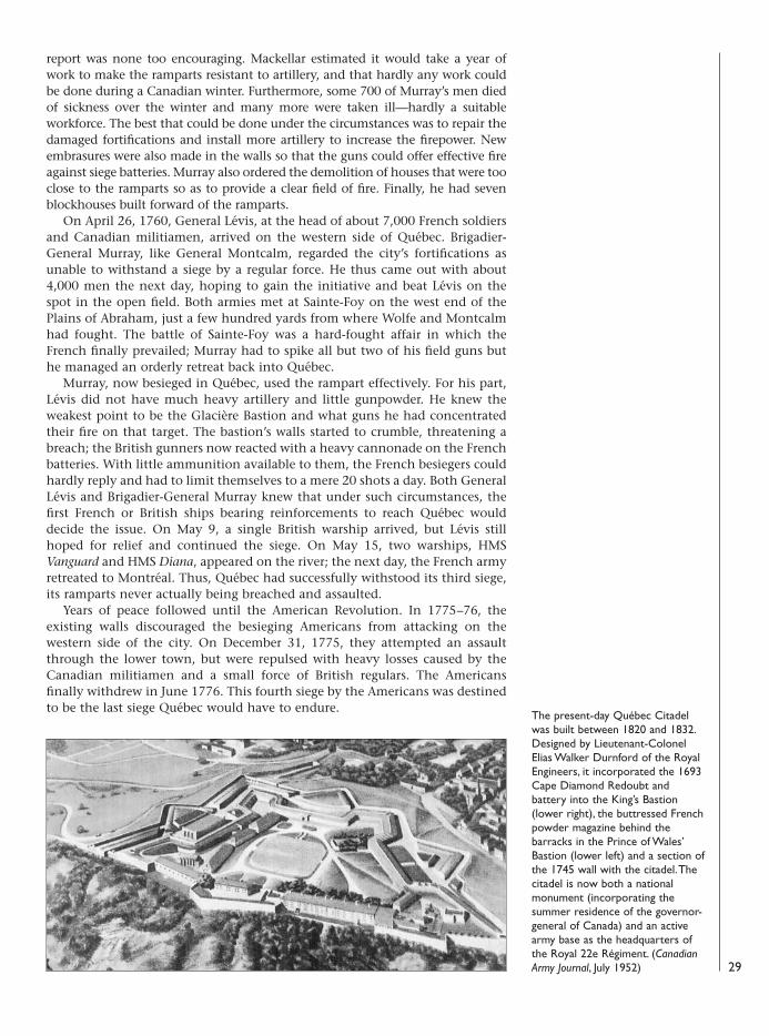
report was none too encouraging. Mackellar estimated it would take a year ofwork to make the ramparts resistant to artillery, and that hardly any work couldbe done during a Canadian winter. Furthermore, some 700 of Murray’s men diedof sickness over the winter and many more were taken ill—hardly a suitableworkforce. The best that could be done under the circumstances was to repair thedamaged fortifications and install more artillery to increase the firepower. Newembrasures were also made in the walls so that the guns could offer effective fireagainst siege batteries. Murray also ordered the demolition of houses that were tooclose to the ramparts so as to provide a clear field of fire. Finally, he had sevenblockhouses built forward of the ramparts.
On April 26, 1760, General Lévis, at the head of about 7,000 French soldiersand Canadian militiamen, arrived on the western side of Québec. Brigadier-General Murray, like General Montcalm, regarded the city’s fortifications asunable to withstand a siege by a regular force. He thus came out with about4,000 men the next day, hoping to gain the initiative and beat Lévis on thespot in the open field. Both armies met at Sainte-Foy on the west end of thePlains of Abraham, just a few hundred yards from where Wolfe and Montcalmhad fought. The battle of Sainte-Foy was a hard-fought affair in which theFrench finally prevailed; Murray had to spike all but two of his field guns buthe managed an orderly retreat back into Québec.
Murray, now besieged in Québec, used the rampart effectively. For his part,Lévis did not have much heavy artillery and little gunpowder. He knew theweakest point to be the Glacière Bastion and what guns he had concentratedtheir fire on that target. The bastion’s walls started to crumble, threatening abreach; the British gunners now reacted with a heavy cannonade on the Frenchbatteries. With little ammunition available to them, the French besiegers couldhardly reply and had to limit themselves to a mere 20 shots a day. Both GeneralLévis and Brigadier-General Murray knew that under such circumstances, thefirst French or British ships bearing reinforcements to reach Québec woulddecide the issue. On May 9, a single British warship arrived, but Lévis stillhoped for relief and continued the siege. On May 15, two warships, HMSVanguard and HMS Diana, appeared on the river; the next day, the French armyretreated to Montréal. Thus, Québec had successfully withstood its third siege,its ramparts never actually being breached and assaulted.
Years of peace followed until the American Revolution. In 1775–76, theexisting walls discouraged the besieging Americans from attacking on thewestern side of the city. On December 31, 1775, they attempted an assaultthrough the lower town, but were repulsed with heavy losses caused by theCanadian militiamen and a small force of British regulars. The Americansfinally withdrew in June 1776. This fourth siege by the Americans was destinedto be the last siege Québec would have to endure.
29
The present-day Québec Citadelwas built between 1820 and 1832.Designed by Lieutenant-ColonelElias Walker Durnford of the RoyalEngineers, it incorporated the 1693Cape Diamond Redoubt andbattery into the King’s Bastion(lower right), the buttressed Frenchpowder magazine behind thebarracks in the Prince of Wales’Bastion (lower left) and a section ofthe 1745 wall with the citadel. Thecitadel is now both a nationalmonument (incorporating thesummer residence of the governor-general of Canada) and an activearmy base as the headquarters ofthe Royal 22e Régiment. (CanadianArmy Journal, July 1952)
08098 FOR27corre.qxd:08098 FOR27corre.qxd 16/3/09 10:39 Page 29
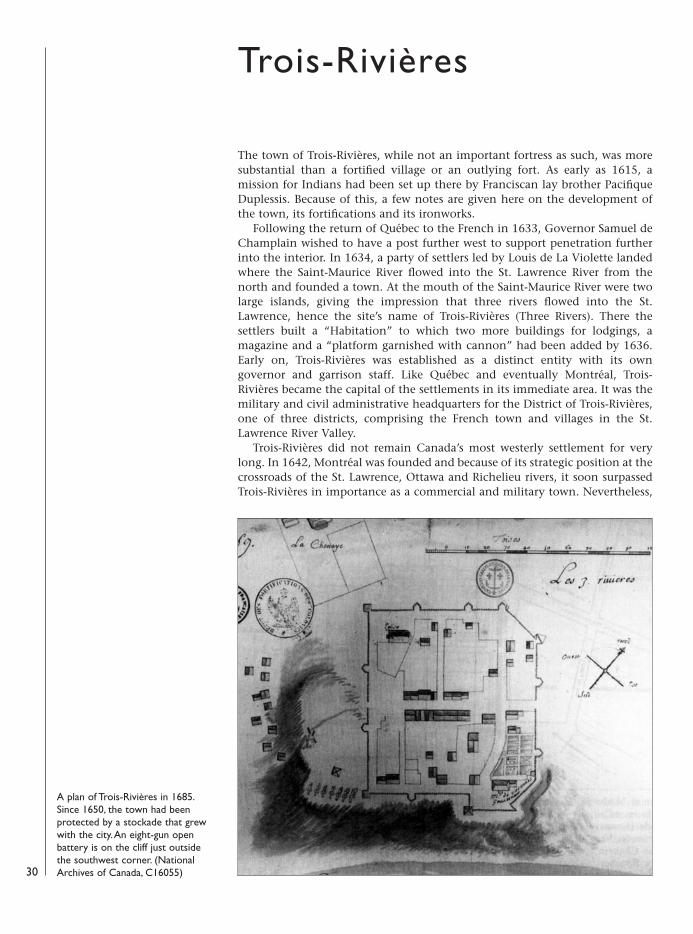
The town of Trois-Rivières, while not an important fortress as such, was moresubstantial than a fortified village or an outlying fort. As early as 1615, amission for Indians had been set up there by Franciscan lay brother PacifiqueDuplessis. Because of this, a few notes are given here on the development ofthe town, its fortifications and its ironworks.
Following the return of Québec to the French in 1633, Governor Samuel deChamplain wished to have a post further west to support penetration furtherinto the interior. In 1634, a party of settlers led by Louis de La Violette landedwhere the Saint-Maurice River flowed into the St. Lawrence River from thenorth and founded a town. At the mouth of the Saint-Maurice River were twolarge islands, giving the impression that three rivers flowed into the St.Lawrence, hence the site’s name of Trois-Rivières (Three Rivers). There thesettlers built a “Habitation” to which two more buildings for lodgings, amagazine and a “platform garnished with cannon” had been added by 1636.Early on, Trois-Rivières was established as a distinct entity with its owngovernor and garrison staff. Like Québec and eventually Montréal, Trois-Rivières became the capital of the settlements in its immediate area. It was themilitary and civil administrative headquarters for the District of Trois-Rivières,one of three districts, comprising the French town and villages in the St.Lawrence River Valley.
Trois-Rivières did not remain Canada’s most westerly settlement for verylong. In 1642, Montréal was founded and because of its strategic position at thecrossroads of the St. Lawrence, Ottawa and Richelieu rivers, it soon surpassedTrois-Rivières in importance as a commercial and military town. Nevertheless,
30
Trois-Rivières
A plan of Trois-Rivières in 1685.Since 1650, the town had beenprotected by a stockade that grewwith the city. An eight-gun openbattery is on the cliff just outsidethe southwest corner. (NationalArchives of Canada, C16055)
08098 FOR27corre.qxd:08098 FOR27corre.qxd 16/3/09 10:39 Page 30
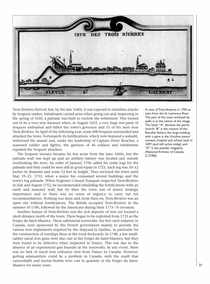
Trois-Rivières thrived; but, by the late 1640s, it was exposed to relentless attacksby Iroquois raiders. Inhabitants carried arms when going out and, beginning inthe spring of 1650, a palisade was built to enclose the settlement. This turnedout to be a very wise measure when, in August 1652, a very large war party ofIroquois ambushed and killed the town’s governor and 15 of his men nearTrois-Rivières. In April of the following year, some 600 Iroquois surrounded andattacked the town. Fortunately its fortifications, which now featured a redoubt,withstood the assault and, under the leadership of Captain Pierre Boucher, aseasoned soldier and fighter, the garrison of 46 soldiers and inhabitantsrepulsed the Iroquois attackers.
The Iroquois menace became far less acute from the later 1660s, but thepalisade wall was kept up and an artillery battery was located just outsideoverlooking the river. An order of January 1706 called for cedar logs for thepalisade and they could be seen still in good repair in 1721. Each log was 10–12inches in diameter and some 12 feet in height. They enclosed the town untilMay 19–21, 1752, when a major fire consumed several buildings and thetown’s log palisade. When Engineer Colonel Franquet inspected Trois-Rivièresin July and August 1752, he recommended rebuilding the fortifications with anearth and masonry wall; but by then the town was of minor strategicimportance and so there was no sense of urgency to carry out hisrecommendations. Nothing was done and, from then on, Trois-Rivières was anopen city without fortifications. The British occupied Trois-Rivières in thesummer of 1760, followed by the Americans during their 1775–76 invasion.
Another feature of Trois-Rivières was the rich deposits of iron ore located ashort distance north of the town. These began to be exploited from 1733 as theForges du Saint-Maurice. These substantial ironworks, the first such industry inCanada, were sponsored by the French government mainly to provide thevarious iron implements required by the shipyard in Québec, in particular forthe construction of warships there at the royal dockyards. In 1748, a few small-caliber naval iron guns were also cast at the Forges du Saint-Maurice, but theywere found to be defective when inspected in France. This was due to theabsence of an experienced gun founder at the ironworks. In any event, therewas no lack of naval iron ordnance sent from France to Canada. However,getting ammunition could be a problem in Canada, with the result thatcannonballs and mortar bombs were cast in quantity at the Forges du Saint-Maurice for many years. 31
A view of Trois-Rivières in 1704 asseen from the St. Lawrence River.The part of the town enclosed bywalls is at the centre of the image.The letter “A” denotes the parishchurch; “B” is the mission of theRecollet fathers; the large buildingwith a spire is the Ursuline sisters’convent, hospital and school, built in1697 (and still active today), and“D” is the powder magazine.(National Archives of Canada,C15784)
08098 FOR27corre.qxd:08098 FOR27corre.qxd 16/3/09 10:39 Page 31
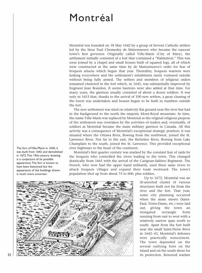
Montréal was founded on 18 May 1642 by a group of fervent Catholic settlersled by the Sieur Paul Chomedey de Maisonneuve who became the nascenttown’s first governor. Originally called Ville-Marie (City of Mary), thesettlement initially consisted of a fort that contained a “Habitation.” This wassoon joined by a chapel and small houses built of squared logs, all of whichwere constructed at the same time by de Maisonneuve’s order for fear ofIroquois attacks which began that year. Thereafter, Iroquois warriors werelurking everywhere and the settlement’s inhabitants rarely ventured outsidewithout being fully armed. The settlers and members of religious ordersremained clustered in the fort which, in 1645, was substantially improved byEngineer Jean Bourdon. It seems bastions were also added at that time. Formany years, the garrison usually consisted of about a dozen soldiers. It wasonly in 1653 that, thanks to the arrival of 100 new settlers, a great clearing ofthe forest was undertaken and houses began to be built in numbers outsidethe fort.
The new settlement was sited on relatively flat ground near the river but hadin the background to the north the majestic Mont-Royal mountain. In time,the name Ville-Marie was replaced by Montréal as the original religious purposeof the settlement was overtaken by the activities of traders and, eventually, ofsoldiers as Montréal became the main military garrison in Canada. All thisactivity was a consequence of Montréal’s exceptional strategic position; it wassituated where the Ottawa River, flowing from the northwest, joined the St.Lawrence River. Not far to the east, the Richelieu River, flowing from LakeChamplain to the south, joined the St. Lawrence. This provided exceptionalriver highways to the heart of the continent.
Montréal’s first quarter century was marked by the constant fear of raids bythe Iroquois who controlled the rivers leading to the town. This changeddrastically from 1665 with the arrival of the Carignan-Salières Regiment. TheFrench, who now had the upper hand militarily, used these same rivers toattack Iroquois villages and expand their trade westward. The town’spopulation shot up from about 75 to 600, plus soldiers.
Up to 1672, Montréal was anill-assorted cluster of variousstructures built not far from theriver and the fort. That year,some city planning occurredwhen the main streets (Saint-Paul, Notre-Dame, etc.) were laidout, giving the town anelongated rectangle formrunning from east to west with arelatively narrow span north tosouth. Apart from the fort builtnear the small Saint-Pierre Riverin 1642–43, Montréal’s defenseswere practically nonexistent.The town depended on theseveral outlying forts on theisland and on the south shore forits protection. Renewed warfare
Montréal
The fort of Ville-Marie in 1645; itwas built from 1642 and demolishedin 1672. This 19th-century drawingis a conjecture of its possibleappearance. The fort is known tohave been bastioned but theappearance of the buildings shownis much more uncertain.
32
08098 FOR27corre.qxd:08098 FOR27corre.qxd 16/3/09 10:39 Page 32
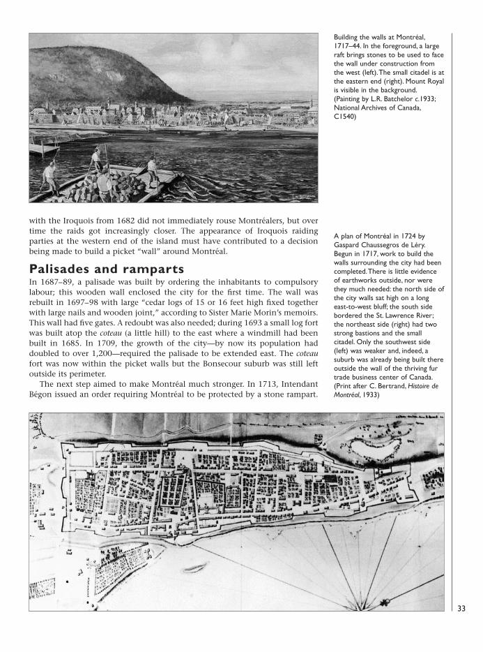
with the Iroquois from 1682 did not immediately rouse Montréalers, but overtime the raids got increasingly closer. The appearance of Iroquois raidingparties at the western end of the island must have contributed to a decisionbeing made to build a picket “wall” around Montréal.
Palisades and rampartsIn 1687–89, a palisade was built by ordering the inhabitants to compulsorylabour; this wooden wall enclosed the city for the first time. The wall wasrebuilt in 1697–98 with large “cedar logs of 15 or 16 feet high fixed togetherwith large nails and wooden joint,” according to Sister Marie Morin’s memoirs.This wall had five gates. A redoubt was also needed; during 1693 a small log fortwas built atop the coteau (a little hill) to the east where a windmill had beenbuilt in 1685. In 1709, the growth of the city—by now its population haddoubled to over 1,200—required the palisade to be extended east. The coteaufort was now within the picket walls but the Bonsecour suburb was still leftoutside its perimeter.
The next step aimed to make Montréal much stronger. In 1713, IntendantBégon issued an order requiring Montréal to be protected by a stone rampart.
Building the walls at Montréal,1717–44. In the foreground, a largeraft brings stones to be used to facethe wall under construction fromthe west (left). The small citadel is atthe eastern end (right). Mount Royalis visible in the background.(Painting by L.R. Batchelor c.1933;National Archives of Canada,C1540)
A plan of Montréal in 1724 byGaspard Chaussegros de Léry.Begun in 1717, work to build thewalls surrounding the city had beencompleted. There is little evidenceof earthworks outside, nor werethey much needed: the north side ofthe city walls sat high on a longeast-to-west bluff; the south sidebordered the St. Lawrence River;the northeast side (right) had twostrong bastions and the smallcitadel. Only the southwest side(left) was weaker and, indeed, asuburb was already being built thereoutside the wall of the thriving furtrade business center of Canada.(Print after C. Bertrand, Histoire deMontréal, 1933)
33
08098 FOR27corre.qxd:08098 FOR27corre.qxd 16/3/09 10:39 Page 33
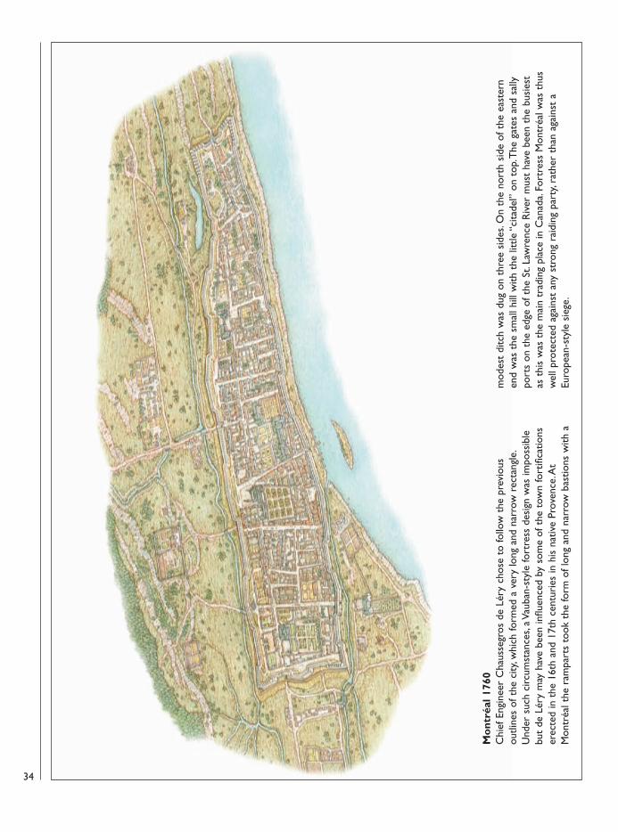
Mo
ntré
al 1
760
Chi
ef E
ngin
eer
Cha
usse
gros
de
Léry
cho
se t
o fo
llow
the
pre
viou
sou
tline
s of
the
city
, whi
ch fo
rmed
a v
ery
long
and
nar
row
rec
tang
le.
Und
er s
uch
circ
umst
ance
s, a
Vaub
an-s
tyle
fort
ress
des
ign
was
impo
ssib
lebu
t de
Lér
y m
ay h
ave
been
influ
ence
d by
som
e of
the
tow
n fo
rtifi
catio
nser
ecte
d in
the
16t
h an
d 17
th c
entu
ries
in h
is n
ativ
e Pr
oven
ce. A
tM
ontr
éal t
he r
ampa
rts
took
the
form
of l
ong
and
narr
ow b
astio
ns w
ith a
mod
est
ditc
h w
as d
ug o
n th
ree
side
s. O
n th
e no
rth
side
of t
he e
aste
rnen
d w
as t
he s
mal
l hill
with
the
litt
le “
cita
del”
on
top.
The
gat
es a
nd s
ally
port
s on
the
edg
e of
the
St.
Law
renc
e R
iver
mus
t ha
ve b
een
the
busi
est
as t
his
was
the
mai
n tr
adin
g pl
ace
in C
anad
a. Fo
rtre
ss M
ontr
éal w
as t
hus
wel
l pro
tect
ed a
gain
st a
ny s
tron
g ra
idin
g pa
rty,
rath
er t
han
agai
nst
aEu
rope
an-s
tyle
sie
ge.
34
08098 FOR27corre.qxd:08098 FOR27corre.qxd 16/3/09 10:39 Page 34
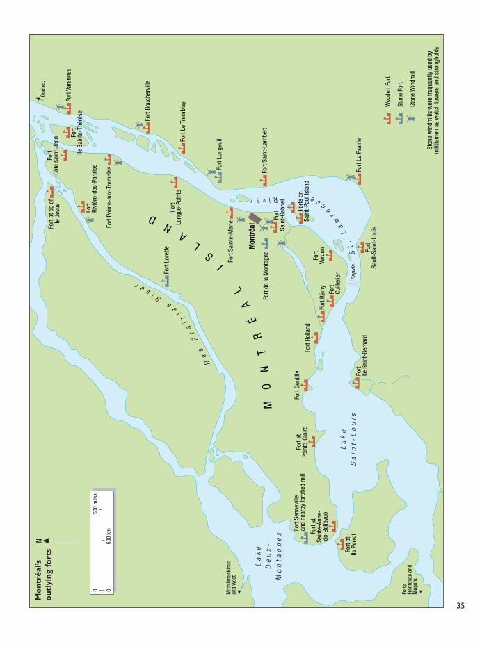
La
ke
De
ux
-M
on
tag
ne
s
La
ke
Sa
int-
Lo
uis
Fort
atSa
inte
-Ann
e-de
-Bel
levu
e
Fort
atIle
Per
rot
Fort
Senn
evill
ean
d ne
arby
forti
fied
mill
Fort
atPo
inte
-Cla
ireFo
rt Ge
ntill
y
Fort
Rolla
nd
Fort
Saul
t-Sa
int-
Loui
s
Fort
La P
rairi
e
Fort
Rém
yFo
rtCu
iller
ier
Fort
Verd
un
Fort
Ile S
aint
-Ber
nard
Fort
Sain
t-La
mbe
rt
Forts
on
Sain
t-Pa
ul Is
land
Fort
de la
Mon
tagn
e
Fort
Sain
t-Ga
brie
l
Mon
tréa
l
Fort
Long
ue-P
oint
e
Fort
Sain
te-M
arie
Fort
Long
euilFo
rt Le
Tre
mbl
ay
Fort
Bouc
herv
ille
Fort
Poin
te-a
ux-T
rem
bles
Fort
Vare
nnes
Fort
Ile S
aint
e-Th
érès
e
Fort
Côte
Sai
nt-J
ean
Fort
Rivi
ère-
des-
Parir
ies
Fort
at ti
p of
Ile J
ésus
Fort
Lore
tte
De
sP
ra
ir
ies
RiverS
t.
La
wre
n
ceRiver
MO
NT
RÉ
AL
I
SL
AN
D
Woo
den
Fort
Ston
e Fo
rt
Ston
e W
indm
ill
Ston
e w
indm
ills
wer
e fre
quen
tly u
sed
bym
ilitia
men
as
wat
ch to
wer
s an
d st
rong
hold
s
Québ
ec
Mic
hilim
acki
nac
and
Wes
t
Forts
Fron
tena
c an
dNi
agar
a
Rapi
ds
N
050
0 m
iles
050
0 km
Mo
ntré
al’s
o
utly
ing
fort
s
35
08098 FOR27corre.qxd:08098 FOR27corre.qxd 16/3/09 10:39 Page 35
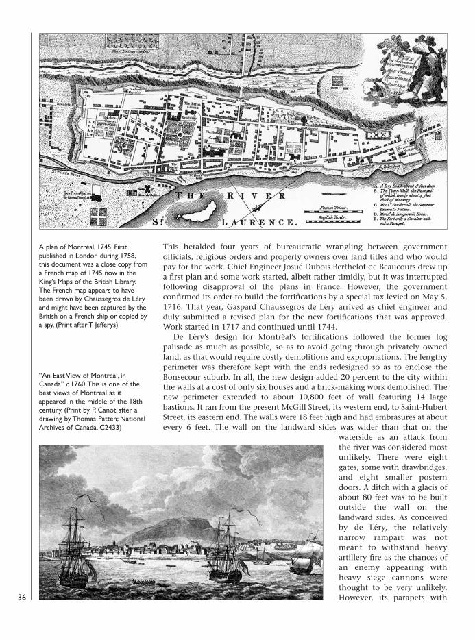
This heralded four years of bureaucratic wrangling between governmentofficials, religious orders and property owners over land titles and who wouldpay for the work. Chief Engineer Josué Dubois Berthelot de Beaucours drew upa first plan and some work started, albeit rather timidly, but it was interruptedfollowing disapproval of the plans in France. However, the governmentconfirmed its order to build the fortifications by a special tax levied on May 5,1716. That year, Gaspard Chaussegros de Léry arrived as chief engineer andduly submitted a revised plan for the new fortifications that was approved.Work started in 1717 and continued until 1744.
De Léry’s design for Montréal’s fortifications followed the former logpalisade as much as possible, so as to avoid going through privately ownedland, as that would require costly demolitions and expropriations. The lengthyperimeter was therefore kept with the ends redesigned so as to enclose theBonsecour suburb. In all, the new design added 20 percent to the city withinthe walls at a cost of only six houses and a brick-making work demolished. Thenew perimeter extended to about 10,800 feet of wall featuring 14 largebastions. It ran from the present McGill Street, its western end, to Saint-HubertStreet, its eastern end. The walls were 18 feet high and had embrasures at aboutevery 6 feet. The wall on the landward sides was wider than that on the
waterside as an attack fromthe river was considered mostunlikely. There were eightgates, some with drawbridges,and eight smaller posterndoors. A ditch with a glacis ofabout 80 feet was to be builtoutside the wall on thelandward sides. As conceivedby de Léry, the relativelynarrow rampart was notmeant to withstand heavyartillery fire as the chances ofan enemy appearing withheavy siege cannons werethought to be very unlikely.However, its parapets with
A plan of Montréal, 1745. Firstpublished in London during 1758,this document was a close copy froma French map of 1745 now in theKing’s Maps of the British Library.The French map appears to havebeen drawn by Chaussegros de Léryand might have been captured by theBritish on a French ship or copied bya spy. (Print after T. Jefferys)
“An East View of Montreal, inCanada” c.1760. This is one of thebest views of Montréal as itappeared in the middle of the 18thcentury. (Print by P. Canot after adrawing by Thomas Patten; NationalArchives of Canada, C2433)
36
08098 FOR27corre.qxd:08098 FOR27corre.qxd 16/3/09 10:39 Page 36
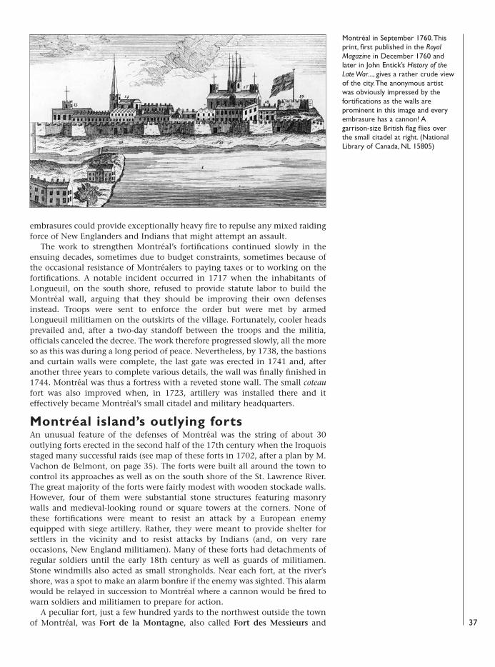
embrasures could provide exceptionally heavy fire to repulse any mixed raidingforce of New Englanders and Indians that might attempt an assault.
The work to strengthen Montréal’s fortifications continued slowly in theensuing decades, sometimes due to budget constraints, sometimes because ofthe occasional resistance of Montréalers to paying taxes or to working on thefortifications. A notable incident occurred in 1717 when the inhabitants ofLongueuil, on the south shore, refused to provide statute labor to build theMontréal wall, arguing that they should be improving their own defensesinstead. Troops were sent to enforce the order but were met by armedLongueuil militiamen on the outskirts of the village. Fortunately, cooler headsprevailed and, after a two-day standoff between the troops and the militia,officials canceled the decree. The work therefore progressed slowly, all the moreso as this was during a long period of peace. Nevertheless, by 1738, the bastionsand curtain walls were complete, the last gate was erected in 1741 and, afteranother three years to complete various details, the wall was finally finished in1744. Montréal was thus a fortress with a reveted stone wall. The small coteaufort was also improved when, in 1723, artillery was installed there and iteffectively became Montréal’s small citadel and military headquarters.
Montréal island’s outlying fortsAn unusual feature of the defenses of Montréal was the string of about 30outlying forts erected in the second half of the 17th century when the Iroquoisstaged many successful raids (see map of these forts in 1702, after a plan by M.Vachon de Belmont, on page 35). The forts were built all around the town tocontrol its approaches as well as on the south shore of the St. Lawrence River.The great majority of the forts were fairly modest with wooden stockade walls.However, four of them were substantial stone structures featuring masonrywalls and medieval-looking round or square towers at the corners. None ofthese fortifications were meant to resist an attack by a European enemyequipped with siege artillery. Rather, they were meant to provide shelter forsettlers in the vicinity and to resist attacks by Indians (and, on very rareoccasions, New England militiamen). Many of these forts had detachments ofregular soldiers until the early 18th century as well as guards of militiamen.Stone windmills also acted as small strongholds. Near each fort, at the river’sshore, was a spot to make an alarm bonfire if the enemy was sighted. This alarmwould be relayed in succession to Montréal where a cannon would be fired towarn soldiers and militiamen to prepare for action.
A peculiar fort, just a few hundred yards to the northwest outside the townof Montréal, was Fort de la Montagne, also called Fort des Messieurs and 37
Montréal in September 1760. Thisprint, first published in the RoyalMagazine in December 1760 andlater in John Entick’s History of theLate War..., gives a rather crude viewof the city. The anonymous artistwas obviously impressed by thefortifications as the walls areprominent in this image and everyembrasure has a cannon! Agarrison-size British flag flies overthe small citadel at right. (NationalLibrary of Canada, NL 15805)
08098 FOR27corre.qxd:08098 FOR27corre.qxd 16/3/09 10:39 Page 37
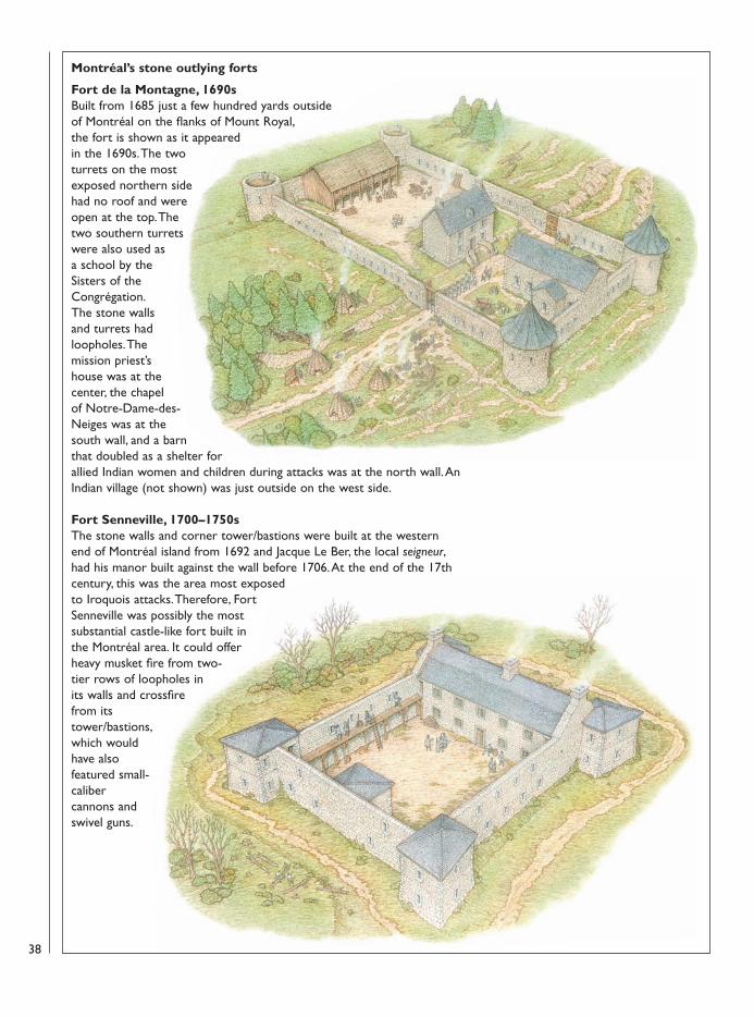
Montréal’s stone outlying forts
Fort de la Montagne, 1690s Built from 1685 just a few hundred yards outsideof Montréal on the flanks of Mount Royal,the fort is shown as it appearedin the 1690s. The twoturrets on the mostexposed northern sidehad no roof and wereopen at the top. Thetwo southern turretswere also used as a school by theSisters of theCongrégation. The stone wallsand turrets hadloopholes. Themission priest’shouse was at thecenter, the chapel of Notre-Dame-des-Neiges was at thesouth wall, and a barnthat doubled as a shelter forallied Indian women and children during attacks was at the north wall. AnIndian village (not shown) was just outside on the west side.
Fort Senneville, 1700–1750sThe stone walls and corner tower/bastions were built at the westernend of Montréal island from 1692 and Jacque Le Ber, the local seigneur,had his manor built against the wall before 1706. At the end of the 17thcentury, this was the area most exposedto Iroquois attacks. Therefore, FortSenneville was possibly the mostsubstantial castle-like fort built inthe Montréal area. It could offerheavy musket fire from two-tier rows of loopholes inits walls and crossfirefrom itstower/bastions,which wouldhave alsofeatured small-calibercannons andswivel guns.
38
08098 FOR27corre.qxd:08098 FOR27corre.qxd 16/3/09 10:39 Page 38
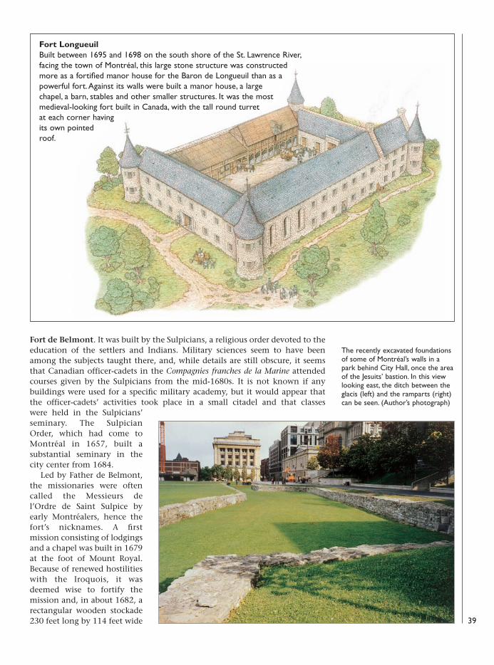
Fort de Belmont. It was built by the Sulpicians, a religious order devoted to theeducation of the settlers and Indians. Military sciences seem to have beenamong the subjects taught there, and, while details are still obscure, it seemsthat Canadian officer-cadets in the Compagnies franches de la Marine attendedcourses given by the Sulpicians from the mid-1680s. It is not known if anybuildings were used for a specific military academy, but it would appear thatthe officer-cadets’ activities took place in a small citadel and that classes were held in the Sulpicians’seminary. The SulpicianOrder, which had come toMontréal in 1657, built asubstantial seminary in thecity center from 1684.
Led by Father de Belmont,the missionaries were oftencalled the Messieurs del’Ordre de Saint Sulpice byearly Montréalers, hence thefort’s nicknames. A firstmission consisting of lodgingsand a chapel was built in 1679at the foot of Mount Royal.Because of renewed hostilitieswith the Iroquois, it wasdeemed wise to fortify themission and, in about 1682, arectangular wooden stockade230 feet long by 114 feet wide
Fort Longueuil Built between 1695 and 1698 on the south shore of the St. Lawrence River,facing the town of Montréal, this large stone structure was constructedmore as a fortified manor house for the Baron de Longueuil than as apowerful fort. Against its walls were built a manor house, a largechapel, a barn, stables and other smaller structures. It was the mostmedieval-looking fort built in Canada, with the tall round turretat each corner havingits own pointedroof.
The recently excavated foundationsof some of Montréal’s walls in apark behind City Hall, once the areaof the Jesuits’ bastion. In this viewlooking east, the ditch between theglacis (left) and the ramparts (right)can be seen. (Author’s photograph)
39
08098 FOR27corre.qxd:08098 FOR27corre.qxd 16/3/09 10:40 Page 39
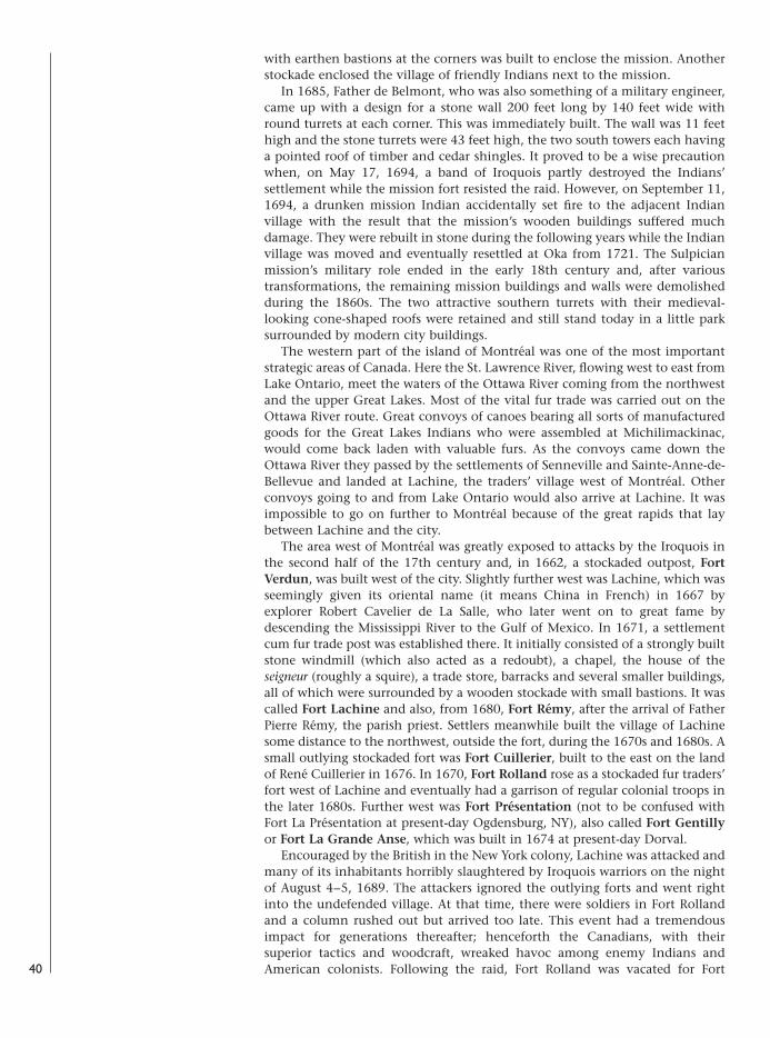
with earthen bastions at the corners was built to enclose the mission. Anotherstockade enclosed the village of friendly Indians next to the mission.
In 1685, Father de Belmont, who was also something of a military engineer,came up with a design for a stone wall 200 feet long by 140 feet wide withround turrets at each corner. This was immediately built. The wall was 11 feethigh and the stone turrets were 43 feet high, the two south towers each havinga pointed roof of timber and cedar shingles. It proved to be a wise precautionwhen, on May 17, 1694, a band of Iroquois partly destroyed the Indians’settlement while the mission fort resisted the raid. However, on September 11,1694, a drunken mission Indian accidentally set fire to the adjacent Indianvillage with the result that the mission’s wooden buildings suffered muchdamage. They were rebuilt in stone during the following years while the Indianvillage was moved and eventually resettled at Oka from 1721. The Sulpicianmission’s military role ended in the early 18th century and, after varioustransformations, the remaining mission buildings and walls were demolishedduring the 1860s. The two attractive southern turrets with their medieval-looking cone-shaped roofs were retained and still stand today in a little parksurrounded by modern city buildings.
The western part of the island of Montréal was one of the most importantstrategic areas of Canada. Here the St. Lawrence River, flowing west to east fromLake Ontario, meet the waters of the Ottawa River coming from the northwestand the upper Great Lakes. Most of the vital fur trade was carried out on theOttawa River route. Great convoys of canoes bearing all sorts of manufacturedgoods for the Great Lakes Indians who were assembled at Michilimackinac,would come back laden with valuable furs. As the convoys came down theOttawa River they passed by the settlements of Senneville and Sainte-Anne-de-Bellevue and landed at Lachine, the traders’ village west of Montréal. Otherconvoys going to and from Lake Ontario would also arrive at Lachine. It wasimpossible to go on further to Montréal because of the great rapids that laybetween Lachine and the city.
The area west of Montréal was greatly exposed to attacks by the Iroquois inthe second half of the 17th century and, in 1662, a stockaded outpost, FortVerdun, was built west of the city. Slightly further west was Lachine, which wasseemingly given its oriental name (it means China in French) in 1667 byexplorer Robert Cavelier de La Salle, who later went on to great fame bydescending the Mississippi River to the Gulf of Mexico. In 1671, a settlementcum fur trade post was established there. It initially consisted of a strongly builtstone windmill (which also acted as a redoubt), a chapel, the house of theseigneur (roughly a squire), a trade store, barracks and several smaller buildings,all of which were surrounded by a wooden stockade with small bastions. It wascalled Fort Lachine and also, from 1680, Fort Rémy, after the arrival of FatherPierre Rémy, the parish priest. Settlers meanwhile built the village of Lachinesome distance to the northwest, outside the fort, during the 1670s and 1680s. Asmall outlying stockaded fort was Fort Cuillerier, built to the east on the landof René Cuillerier in 1676. In 1670, Fort Rolland rose as a stockaded fur traders’fort west of Lachine and eventually had a garrison of regular colonial troops inthe later 1680s. Further west was Fort Présentation (not to be confused withFort La Présentation at present-day Ogdensburg, NY), also called Fort Gentillyor Fort La Grande Anse, which was built in 1674 at present-day Dorval.
Encouraged by the British in the New York colony, Lachine was attacked andmany of its inhabitants horribly slaughtered by Iroquois warriors on the nightof August 4–5, 1689. The attackers ignored the outlying forts and went rightinto the undefended village. At that time, there were soldiers in Fort Rollandand a column rushed out but arrived too late. This event had a tremendousimpact for generations thereafter; henceforth the Canadians, with theirsuperior tactics and woodcraft, wreaked havoc among enemy Indians andAmerican colonists. Following the raid, Fort Rolland was vacated for Fort40
08098 FOR27corre.qxd:08098 FOR27corre.qxd 16/3/09 10:40 Page 40
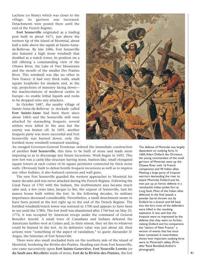
Lachine (or Rémy) which was closer to thevillage; its garrison was increased.Detachments were posted there until theend of the French Regime.
Fort Senneville originated as a tradingpost built in about 1671, just above thewestern tip of the island of Montréal, abouthalf a mile above the rapids at Sainte-Anne-de-Bellevue. By late 1686, Fort Sennevillealso featured a high stone windmill thatdoubled as a watch tower, its position on ahill offering a commanding view of theOttawa River, the Lake of Two Mountainsand the mouth of the smaller Des PrairiesRiver. This windmill was like no other inNew France: it had very thick walls, smallsquare loopholes for muskets and, at thetop, projections of masonry facing down—the machicolations of medieval castles inEurope—to enable lethal liquids and rocksto be dropped onto any attackers.
In October 1687, the nearby village ofSainte-Anne-de-Bellevue (a stockade calledFort Sainte-Anne had been there sinceabout 1683) and the Senneville mill wereattacked by marauding Iroquois; severalsettlers were killed in the area but theenemy was beaten off. In 1691, anotherIroquois party was more successful and FortSenneville was burned down; only thefortified stone windmill remained standing.An enraged Governor-General Frontenac ordered the immediate constructionof another Fort Senneville, this time to be built of stone and made moreimposing so as to discourage any future incursions. Work began in 1692. Thisnew fort was a castle-like structure having stone, bastion-like, small elongatedsquare towers at each corner of its square perimeter connected by thick stonewalls. Obviously built to defeat hostile Iroquois incursions as well as to impressany other Indians, it also featured cannons and wall guns.
The new Fort Senneville guarded the western approaches to Montréal formany decades and was never attacked during the French Regime. Following theGreat Peace of 1701 with the Indians, the northwestern area became muchsafer and, a few years later, Jacque Le Ber, the seigneur of Senneville, had hismanor house built within the fort. In the following decades, its militaryimportance decreased considerably. Nevertheless, a small detachment seems tohave been posted at the fort right up to the end of the French Regime. Thefortified windmill/watch tower was restored in 1700 and appears to have beenin use until the 1780s. The fort itself was abandoned after 1760 but on May 25,1776, it was occupied by American troops under the command of GeneralBenedict Arnold. A small force of Canadians and Indians defeated theAmericans further west at Cedars and, in their retreat, they set fire to whatevercould be burned in the fort. As its defensive value was just about nil, theiractions were “something of the aspect of vandalism,” to quote Alexander D.Angus, the historian of Fort Senneville.
There were also small stockaded forts on the northern side of the island ofMontréal, bordering the Rivière-des-Prairies. Heading east from Fort Senneville,one came successively upon Fort Sainte-Geneviève, Fort Nouvelle Lorette (ordu Sault-aux-Récollets) made of stone, Fort de la Rivière-des-Prairies, the fort 41
The defense of Montréal was largelydependent on outlying forts. In1660, Adam Dollard des Ormeaux,the young commandant of the smallgarrison of Montréal, went up theOttawa River with 16 Frenchcompanions and 44 Indian allies.Meeting a large party of Iroquoiswarriors descending the river toattack Montréal, Dollard and hismen put up an heroic defense in aramshackle Indian picket fort atLong Sault. Most of the Indian alliesdefected. In the final assault, apowder barrel thrown out byDollard hit a branch and fell backinto the fort; most of the defenderswere killed in the resultingexplosion. It was said that theIroquois were so impressed by thedefense that they went no further,making Dollard and his companionsthe “saviors of New France;” aversion of events that has sincebeen contested. It neverthelessshows how important outlying fortswere to Montréal’s safety. (Printafter René Bombled; Author’sphotograph)
08098 FOR27corre.qxd:08098 FOR27corre.qxd 16/3/09 10:40 Page 41
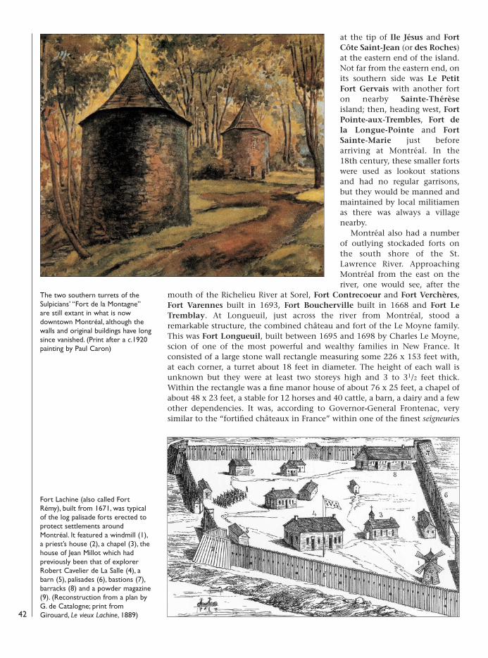
at the tip of Ile Jésus and FortCôte Saint-Jean (or des Roches)at the eastern end of the island.Not far from the eastern end, onits southern side was Le PetitFort Gervais with another forton nearby Sainte-Thérèseisland; then, heading west, FortPointe-aux-Trembles, Fort dela Longue-Pointe and FortSainte-Marie just beforearriving at Montréal. In the18th century, these smaller fortswere used as lookout stationsand had no regular garrisons,but they would be manned andmaintained by local militiamenas there was always a villagenearby.
Montréal also had a numberof outlying stockaded forts onthe south shore of the St.Lawrence River. ApproachingMontréal from the east on theriver, one would see, after the
mouth of the Richelieu River at Sorel, Fort Contrecoeur and Fort Verchères,Fort Varennes built in 1693, Fort Boucherville built in 1668 and Fort LeTremblay. At Longueuil, just across the river from Montréal, stood aremarkable structure, the combined château and fort of the Le Moyne family.This was Fort Longueuil, built between 1695 and 1698 by Charles Le Moyne,scion of one of the most powerful and wealthy families in New France. Itconsisted of a large stone wall rectangle measuring some 226 x 153 feet with,at each corner, a turret about 18 feet in diameter. The height of each wall isunknown but they were at least two storeys high and 3 to 31/2 feet thick.Within the rectangle was a fine manor house of about 76 x 25 feet, a chapel ofabout 48 x 23 feet, a stable for 12 horses and 40 cattle, a barn, a dairy and a fewother dependencies. It was, according to Governor-General Frontenac, verysimilar to the “fortified châteaux in France” within one of the finest seigneuries
42
The two southern turrets of theSulpicians’ “Fort de la Montagne”are still extant in what is nowdowntown Montréal, although thewalls and original buildings have longsince vanished. (Print after a c.1920painting by Paul Caron)
Fort Lachine (also called FortRémy), built from 1671, was typicalof the log palisade forts erected toprotect settlements aroundMontréal. It featured a windmill (1),a priest’s house (2), a chapel (3), thehouse of Jean Millot which hadpreviously been that of explorerRobert Cavelier de La Salle (4), abarn (5), palisades (6), bastions (7),barracks (8) and a powder magazine(9). (Reconstruction from a plan byG. de Catalogne; print fromGirouard, Le vieux Lachine, 1889)
08098 FOR27corre.qxd:08098 FOR27corre.qxd 16/3/09 10:40 Page 42
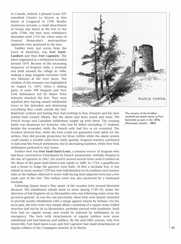
in Canada. Indeed, a pleased Louis XIVennobled Charles Le Moyne as firstbaron of Longueuil in 1700. Besidesnumerous servants, a small detachmentof troops was based at the fort in theearly 1700s, but they were withdrawnthereafter until 1755–60, when some ofGeneral Montcalm’s metropolitanregiments were quartered in the area.
Further west, just across from thetown of Montréal, was Fort Saint-Lambert and then Fort Laprairie. Thelatter originated in a settlement foundedaround 1670. Because of the increasingfrequency of Iroquois raids, a stockadewas built around the village in 1684,making a large irregular enclosure withtwo bastions at the river shore. Thewisdom of this measure was highlightedon August 11, 1691, when a raidingparty of some 300 Iroquois and NewYork militiamen led by Major PeterSchuyler attacked the fort. They wererepulsed after having caused substantiallosses to the defenders and destroyingeverything they could outside the fort.Relatively content and feeling they had nothing to fear, Schuyler and his menstarted back toward Albany. But the alarm had been raised and some 700French troops and Canadian militiamen caught up with them. The ensuingbattle was disastrous for Schuyler, who lost 83 killed (including 17 Indians)besides the wounded, while the French only had five or six wounded. Theincident showed that, while the forts could not guarantee total safety for thesettlers, they did provide protection for those within while the alarm systemcould muster a sizeable relief force fairly quickly. Iroquois warriors continuedto lurk near the French settlements, but in decreasing numbers, while New Yorkmilitiamen preferred to stay home.
Further west was Fort Sault-Saint-Louis, a mission reserve of Iroquois whohad been converted to Christianity by French missionaries. Initially situated atthe site of Laprairie in 1667, the reserve moved several times until it settled onthe shore of the great Sault-Saint-Louis rapids in 1689. In 1724, a guardhouseand a house to lodge the garrison were built. At first a stockade fort, it wasrebuilt in stone around 1729 but only half-finished on its southern and westernsides as the Indians objected to stone walls facing their adjacent town just a fewyards east of the fort. This Indian town was also protected by a bastionedstockade.
Following Queen Anne’s War, many of the wooden forts around Montréaldecayed. The inhabitants rebuilt them in stone during 1729–30, under thedirection of Sub-Engineer de La Morandière who was following orders from thegovernor-general. As was the case previously, these forts were mainly intendedto provide nearby inhabitants with a refuge against attacks by Indians. For themost part, the forts were very simple affairs consisting of a square stone-walledstructure laid out by de La Morandière, probably pierced with loopholes. Suchforts had no regular troops and would be manned by militiamen in anemergency. The forts with detachments of regular soldiers were moresubstantial and had bastions and artillery. By the mid-18th century, only FortSenneville, Fort Sault-Saint-Louis and Fort Laprairie had small detachments ofregular soldiers of the Compagnies franches de la Marine. 43
The remains of the fortifiedwindmill and watch tower at FortSenneville as seen in the 1870s.(Picturesque Canada…1882)
08098 FOR27corre.qxd:08098 FOR27corre.qxd 16/3/09 10:40 Page 43
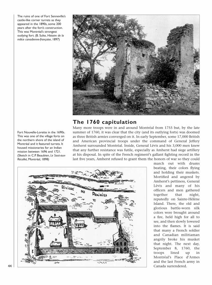
The 1760 capitulationMany more troops were in and around Montréal from 1755 but, by the latesummer of 1760, it was clear that the city (and its outlying forts) was doomedas three British armies converged on it. In early September, some 17,000 Britishand American provincial troops under the command of General JefferyAmherst surrounded Montréal. Inside, General Lévis and his 3,000 men knewthat any further resistance was futile, especially as Amherst had siege artilleryat his disposal. In spite of the French regiment’s gallant fighting record in thelast five years, Amherst refused to grant them the honors of war so they could
march out with drumsbeating, their colors flyingand holding their muskets.Mortified and angered byAmherst’s pettiness, GeneralLévis and many of hisofficers and men gatheredtogether that night,reputedly on Sainte-HélèneIsland. There, the old andglorious battle-worn silkcolors were brought arounda fire, held high for all tosee, and then slowly loweredinto the flames. It is saidthat many a French soldierand Canadian militiamanangrily broke his musketthat night. The next day,September 8, 1760, thetroops lined up inMontréal’s Place d’Armesand the last French army inCanada surrendered.
The ruins of one of Fort Senneville’scastle-like corner turrets as theyappeared in the 1890s, some 200years after the fort’s construction.This was Montréal’s strongestoutlying fort. (B. Sulte, Histoire de lamilice canadienne-française, 1897)
Fort Nouvelle-Lorette in the 1690s.This was one of the village forts onthe northern shore of the island ofMontréal and it featured turrets. Ithoused missionaries for an Indianmission between 1696 and 1721.(Sketch in C.P. Beaubien, Le Saut-aux-Récollet, Montréal, 1898)
44
08098 FOR27corre.qxd:08098 FOR27corre.qxd 16/3/09 10:40 Page 44

During the 17th century, France also had two small colonies on the AtlanticCoast: Acadia, which was essentially in the western part of present-day NovaScotia with outposts in New Brunswick and the American state of Maine; andthe harbor of Placentia in Newfoundland. The Treaty of Utrecht, signed byBritain and France in 1713, conceded Acadia (which confirmed it as NovaScotia) and Newfoundland to Britain. France, however, kept Cape Breton Islandand Isle Saint-Jean (the future Prince Edward Island). That year, Frenchcolonists arrived at Isle Royale, as Cape Breton Island was now known. In 1719,one of the island’s best harbors was selected to become a fortress and naval basecalled Louisbourg. It was inaugurated in 1720 and, for the next 23 years, a townrose surrounded by substantial fortifications. It has often been told how LouisXV had once remarked, when presented with more bills to pay for Louisbourg’sconstruction, that he expected to see its spires from Versailles! The story is, nodoubt, apocryphal. In fact, it cost only a small part of France’s vast recurringexpenses for works on dozens of other fortresses at the time. Indeed,Louisbourg never even had a real citadel.
Building Louisbourg was nevertheless an expensive undertaking largely dueto its remote location. However, it was a commercial success. It providedFrench Grand Banks fishermen with a secure harbor; their activities, which hadbeen ruined during Queen Anne’s War, were totally redressed by 1718 andexpanded thereafter. Louisbourg’s harbor also became the scene of intensemaritime traffic from France, Canada and the West Indies; and from Britain’s13 colonies, which included a fair amount of smuggling.
Louisbourg
A view of Louisbourg in 1731. Justover a decade after its foundation,the town had flourished andachieved the general appearance itwould keep until July 1758. (Printafter Verrier)
45
08098 FOR27corre.qxd:08098 FOR27corre.qxd 16/3/09 10:40 Page 45
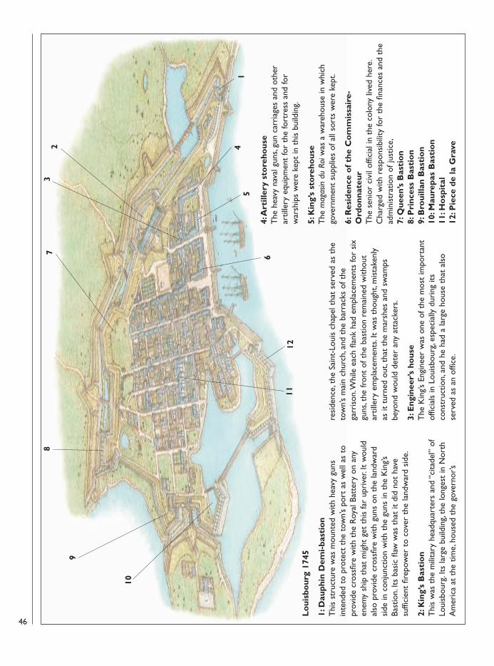
Lo
uisb
our
g 17
45
1: D
auph
in D
emi-
bast
ion
Thi
s st
ruct
ure
was
mou
nted
with
hea
vy g
uns
inte
nded
to
prot
ect
the
tow
n’s
port
as
wel
l as
topr
ovid
e cr
ossfi
re w
ith t
he R
oyal
Bat
tery
on
any
enem
y sh
ip t
hat
mig
ht g
et t
his
far
upri
v er.
It w
ould
also
pro
vide
cro
ssfir
e w
ith g
uns
on t
he la
ndw
ard
side
in c
onju
nctio
n w
ith t
he g
uns
in t
he K
ing’s
Bast
ion.
Its
basi
c fla
w w
as t
hat
it di
d no
t ha
vesu
ffici
ent
firep
ower
to
cove
r th
e la
ndw
ard
side
.
2: K
ing’
s B
asti
on
Thi
s w
as t
he m
ilita
ry h
eadq
uart
ers
and
“cita
del”
of
Loui
sbou
rg. I
ts la
rge
build
ing,
the
long
est
in N
orth
Am
eric
a at
the
tim
e, h
ouse
d th
e go
vern
or’s
resi
denc
e, t
he S
aint
-Lou
is c
hape
l tha
t se
rved
as
the
tow
n’s
mai
n ch
urch
, and
the
bar
rack
s of
the
garr
ison
. Whi
le e
ach
flank
had
em
plac
emen
ts fo
r si
xgu
ns, t
he fr
ont
of t
he b
astio
n re
mai
ned
with
out
artil
lery
em
plac
emen
ts. I
t w
as t
houg
ht, m
ista
kenl
yas
it t
urne
d ou
t, th
at t
he m
arsh
es a
nd s
wam
psbe
yond
wou
ld d
eter
any
att
acke
rs.
3: E
ngin
eer’
s ho
use
The
Kin
g’s E
ngin
eer
was
one
of t
he m
ost
impo
rtan
tof
ficia
ls in
Lou
isbo
urg,
espe
cial
ly d
urin
g its
cons
truc
tion,
and
he
had
a la
rge
hous
e th
at a
lso
serv
ed a
s an
offi
ce.
4: A
rtill
ery
sto
reho
use
The
hea
vy n
a val
gun
s, gu
n ca
rria
ges
and
othe
rar
tille
ry e
quip
men
t fo
r th
e fo
rtre
ss a
nd fo
rw
arsh
ips
wer
e ke
pt in
thi
s bu
ildin
g.
5: K
ing’
s st
ore
hous
e T
he m
agas
in d
u Ro
iwas
a w
areh
ouse
in w
hich
gove
rnm
ent
supp
lies
of a
ll so
rts
wer
e ke
pt.
6: R
esid
ence
of
the
Co
mm
issa
ire-
Ord
onn
ateu
r T
he s
enio
r ci
vil o
ffici
al in
the
col
ony
lived
her
e.C
harg
ed w
ith r
espo
nsib
ility
for
the
finan
ces
and
the
adm
inis
trat
ion
of ju
stic
e,7:
Que
en’s
Bas
tio
n 8:
Pri
nces
s B
asti
on
9: B
roui
llan
Bas
tio
n10
: Mau
repa
s B
asti
on
11: H
osp
ital
12: P
iece
de
la G
rave2
5
6
3
4
1112
78
9
10
1
46
08098 FOR27corre.qxd:08098 FOR27corre.qxd 16/3/09 10:40 Page 46
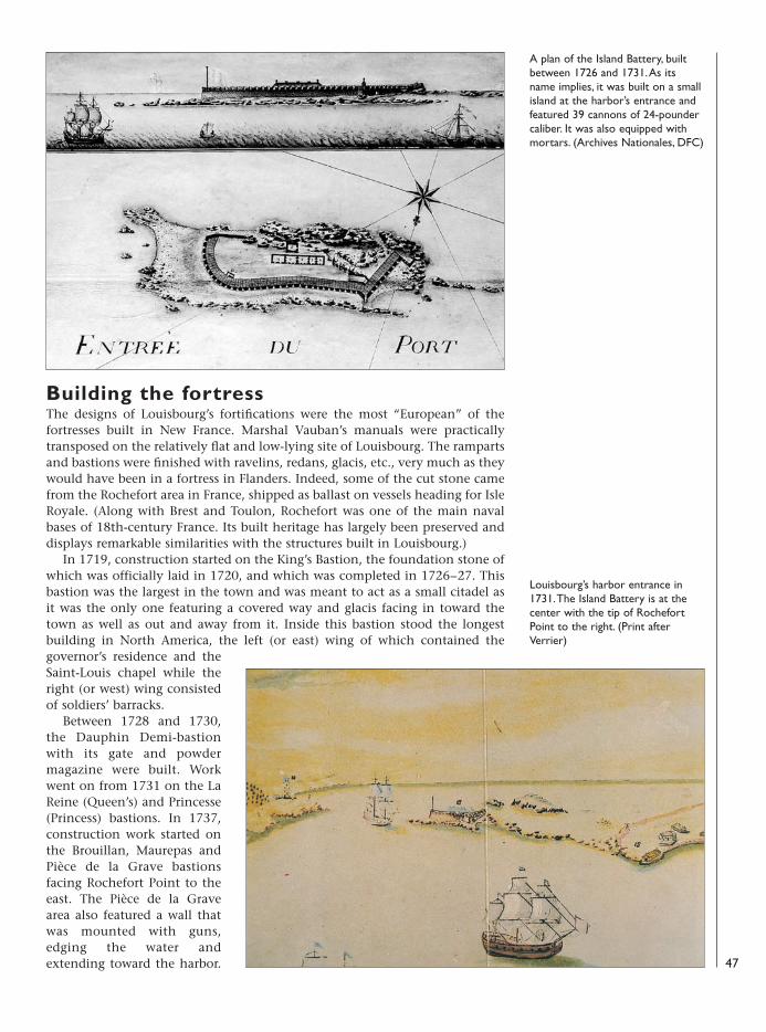
Building the fortressThe designs of Louisbourg’s fortifications were the most “European” of thefortresses built in New France. Marshal Vauban’s manuals were practicallytransposed on the relatively flat and low-lying site of Louisbourg. The rampartsand bastions were finished with ravelins, redans, glacis, etc., very much as theywould have been in a fortress in Flanders. Indeed, some of the cut stone camefrom the Rochefort area in France, shipped as ballast on vessels heading for IsleRoyale. (Along with Brest and Toulon, Rochefort was one of the main navalbases of 18th-century France. Its built heritage has largely been preserved anddisplays remarkable similarities with the structures built in Louisbourg.)
In 1719, construction started on the King’s Bastion, the foundation stone ofwhich was officially laid in 1720, and which was completed in 1726–27. Thisbastion was the largest in the town and was meant to act as a small citadel asit was the only one featuring a covered way and glacis facing in toward thetown as well as out and away from it. Inside this bastion stood the longestbuilding in North America, the left (or east) wing of which contained thegovernor’s residence and theSaint-Louis chapel while theright (or west) wing consistedof soldiers’ barracks.
Between 1728 and 1730,the Dauphin Demi-bastionwith its gate and powdermagazine were built. Workwent on from 1731 on the LaReine (Queen’s) and Princesse(Princess) bastions. In 1737,construction work started onthe Brouillan, Maurepas andPièce de la Grave bastionsfacing Rochefort Point to theeast. The Pièce de la Gravearea also featured a wall thatwas mounted with guns,edging the water andextending toward the harbor.
A plan of the Island Battery, builtbetween 1726 and 1731. As itsname implies, it was built on a smallisland at the harbor’s entrance andfeatured 39 cannons of 24-poundercaliber. It was also equipped withmortars. (Archives Nationales, DFC)
Louisbourg’s harbor entrance in1731. The Island Battery is at thecenter with the tip of RochefortPoint to the right. (Print afterVerrier)
47
08098 FOR27corre.qxd:08098 FOR27corre.qxd 16/3/09 10:40 Page 47
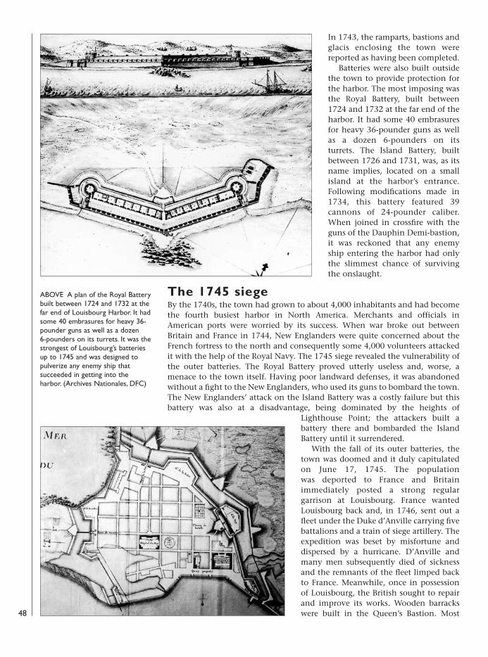
In 1743, the ramparts, bastions andglacis enclosing the town werereported as having been completed.
Batteries were also built outsidethe town to provide protection forthe harbor. The most imposing wasthe Royal Battery, built between1724 and 1732 at the far end of theharbor. It had some 40 embrasuresfor heavy 36-pounder guns as wellas a dozen 6-pounders on itsturrets. The Island Battery, builtbetween 1726 and 1731, was, as itsname implies, located on a smallisland at the harbor’s entrance.Following modifications made in1734, this battery featured 39cannons of 24-pounder caliber.When joined in crossfire with theguns of the Dauphin Demi-bastion,it was reckoned that any enemyship entering the harbor had onlythe slimmest chance of survivingthe onslaught.
The 1745 siegeBy the 1740s, the town had grown to about 4,000 inhabitants and had becomethe fourth busiest harbor in North America. Merchants and officials inAmerican ports were worried by its success. When war broke out betweenBritain and France in 1744, New Englanders were quite concerned about theFrench fortress to the north and consequently some 4,000 volunteers attackedit with the help of the Royal Navy. The 1745 siege revealed the vulnerability ofthe outer batteries. The Royal Battery proved utterly useless and, worse, amenace to the town itself. Having poor landward defenses, it was abandonedwithout a fight to the New Englanders, who used its guns to bombard the town.The New Englanders’ attack on the Island Battery was a costly failure but thisbattery was also at a disadvantage, being dominated by the heights of
Lighthouse Point; the attackers built abattery there and bombarded the IslandBattery until it surrendered.
With the fall of its outer batteries, thetown was doomed and it duly capitulatedon June 17, 1745. The population was deported to France and Britainimmediately posted a strong regulargarrison at Louisbourg. France wantedLouisbourg back and, in 1746, sent out afleet under the Duke d’Anville carrying fivebattalions and a train of siege artillery. Theexpedition was beset by misfortune anddispersed by a hurricane. D’Anville andmany men subsequently died of sicknessand the remnants of the fleet limped backto France. Meanwhile, once in possessionof Louisbourg, the British sought to repairand improve its works. Wooden barrackswere built in the Queen’s Bastion. Most
ABOVE A plan of the Royal Batterybuilt between 1724 and 1732 at thefar end of Louisbourg Harbor. It hadsome 40 embrasures for heavy 36-pounder guns as well as a dozen6-pounders on its turrets. It was thestrongest of Louisbourg’s batteriesup to 1745 and was designed topulverize any enemy ship thatsucceeded in getting into theharbor. (Archives Nationales, DFC)
48
08098 FOR27corre.qxd:08098 FOR27corre.qxd 16/3/09 10:40 Page 48
notably, the Dauphin Demi-bastion was strengthened by directing its mainfirepower out of the ramparts rather than into the harbor and adding a cavalieron the battery, thus creating two superimposed rows of cannon emplacements.
Returned to French possessionUnder the terms of the Treaty of Aix-la-Chapelle signed in 1748, Louisbourgwas returned to France. Needless to say, the New Englanders were quite upsetabout Britain’s view that Madras in India was more important than themenacing fortress just to the north of them. Back in French possession in 1749,the fortress looked formidable but was in fact in poor condition. By the early1750s, its fortifications had many defects. The masonry was crumbling andneeded repair. The engineers’ efforts were generally ineffective as a great deal ofmoney—far more than the French treasury was willing to spend—was neededto put things right. To be truly safe, the Royal Battery required the addition ofmajor defenses on its landward side. A strong fort needed to be built onLighthouse Point to fully secure the harbor’s entrance and prevent the IslandBattery from being bombarded from that high point. The town’s ramparts andbastions needed counterguards, ravelins and demi-lunes. Most of all, if it wasgoing to be a truly powerful fortress that could repulse a major besieging force,Louisbourg needed a large citadel. Such a project seemed so hopeless, insofar asofficial approval in Versailles was concerned that engineers in Louisbourg didnot even propose detailed plans because they knew that they wouldbe rejected.
The French government’s emphasis was on rebuilding trade and commerceand, within a few years, Louisbourg was flourishing again with a population ofabout 4,500. Nevertheless, some improvements were made in the Queen’sBastion with a demi-lune built there from 1754. A battery was also built atRochefort Point. Overall, however, the town’s defenses had not been improvedsignificantly by the time war broke out again in 1756, nor would they be two 49
OPPOSITE A plan of Louisbourg in1741. Most of the constructionwork had been completed by thatdate except at the Pièce de laGrave (lower left). (ArchivesNationales, DFC)
Louisbourg, reconstructed as itlooked in 1744–45. During the 1960sand 1970s, part of the fortress wasrebuilt as a heritage site. The town’smain battery, the Dauphin Demi-bastion, is in the foreground with theDauphin gate. (Parks Canada)
08098 FOR27corre.qxd:08098 FOR27corre.qxd 16/3/09 10:40 Page 49
Lo
uisb
our
g 17
58
The
mai
n fe
atur
es o
f Lou
isbo
urg
duri
ng it
s se
cond
sie
ge in
175
8 w
ere
broa
dly
sim
ilar
to t
hose
in 1
745
(see
pag
e 46
). T
he w
alls
and
bui
ldin
gs w
ere
muc
h th
esa
me
exce
pt fo
r im
prov
emen
ts in
the
Dau
phin
Dem
i-bas
tion,
whi
ch h
ad b
een
rebu
ilt w
ith a
cav
alie
r so
as
to c
over
the
land
sid
e w
ith a
rtill
ery
fire.
D
espi
te t
he s
piri
ted
coun
ter -
fire
by t
he F
renc
h gu
nner
s, th
e re
lent
less
bom
bard
men
t of
the
fort
ress
by
Gen
eral
Am
hers
t’s a
nd A
dmir
al B
osca
wen
’sgu
nner
s ha
d in
flict
ed h
eavy
dam
age
on t
he fo
rtifi
catio
ns b
y th
e la
st w
eek
of Ju
ly17
58. B
y Ju
ly 2
4–25
, the
top
of t
he c
aval
ier
and
the
wal
ls o
f the
Dau
phin
Dem
i-ba
stio
n an
d th
e K
ing’s
Bas
tion
had
been
red
uced
to
rubb
le; p
art
of t
he K
ing’s
Bast
ion
and
the
barr
acks
in t
he Q
ueen
’s Ba
stio
n w
ere
burn
ing,
as w
ere
som
eho
uses
in t
he t
own.
Even
mor
e cr
itica
l was
the
bre
ach
in t
he c
urta
in w
all b
etw
een
the
Dau
phin
Dem
i-bas
tion
and
the
Kin
g’ s B
astio
n. T
his
gave
the
Bri
tish
the
optio
n of
atte
mpt
ing
an a
ssau
lt in
to t
he t
own.
In s
pite
of i
ts p
artia
lly fi
lled
moa
t (s
eefo
regr
ound
), st
orm
ing
the
tow
n vi
a th
is la
rge
brea
ch h
ad e
very
cha
nce
ofsu
cces
s. T
he c
onse
quen
ces
of s
uch
assa
ults
wer
e co
stly
in li
ves
for
both
sid
esan
d lik
ely
mea
nt a
dir
e fa
te fo
r th
e ci
vilia
ns a
t th
e ha
nds
of e
nem
y so
ldie
rs h
alf-
craz
ed fr
om t
he fi
ghtin
g. W
hen
fort
ress
es r
each
ed t
he p
oint
of b
eing
par
tlyde
stro
yed
and
brea
ched
, fur
ther
figh
ting
was
con
side
red
usel
ess
and
nego
tiatio
ns le
adin
g to
sur
rend
er w
ere
held
. Thi
s is
wha
t ha
ppen
ed a
tLo
uisb
ourg
, whi
ch s
urre
nder
ed o
n Ju
ly 2
6, a
fter
its
wal
ls h
ad b
een
brea
ched
.
50
08098 FOR27corre.qxd:08098 FOR27corre.qxd 16/3/09 10:41 Page 50
years later when a large British fleet carrying over 10,000 troops led by SirJeffery Amherst was sighted off Louisbourg.
Less expensive but necessary work that had been done concerned buildingfield fortifications at the most likely landing site for an enemy army. The shoresaround Louisbourg were very rocky and the only real landing beach nearby wasat La Comorandière (later renamed Kennington Cove). This was where the NewEnglanders had landed in 1745. In 1757, parapets and fascines were positionedon the beach at La Comorandière. A trench behind the parapets and fascinesran the length of the site, punctuated by the occasional battery of 6-poundersand swivel guns.
The 1758 siegeRough weather and the field fortifications at Kennington Cove initially causeddifficulties for the British when they tried to land troops on June 8, 1758.Brigadier James Wolfe managed to land with his men, rush up a cliff andoutflank the defenders, who retreated into town. The second siege ofLouisbourg was a hard-fought affair lasting seven weeks. Outnumbered, theFrench garrison put up an outstanding fight to delay the British as much aspossible so that it would be too late for them to go on and attack Québec. Thistime, the French rendered the Royal Battery largely useless before the siege, butGeneral Amherst had plenty of guns and pioneers to build his own powerfulsiege batteries. As a fort had not been built on Lighthouse Point, the Britishagain built a battery there that battled for days with the French colonialartillery gunners in the Island Battery below. Finally, on July 26, after a breachhad been made near the Dauphin Demi-bastion, the much-battered fortresssurrendered.
Although the fortifications were badly damaged and the town partly in ruinsas a result of the bombardments, there was still a chance that it might berendered a viable fortress again with some determined repairs. In Britain as inNew England, many worried that Louisbourg might be recaptured by theFrench or, as in 1748, returned to France at the end of the war. The menacesimply had to be removed. Thus, in February 1760, it was “His Majesty’s ordersand Mr. Pitt’s” that “all the Fortifications, Works and Deffences whatever shallbe totally demolished and Razed.”Colonel Bastide, Royal Engineers, whohad supervised the 1758 siegeoperations, was put in charge of thedemolition work. A Company ofMiners, especially raised in England forthe purpose, arrived in May and startedblowing up the defenses. The summerwas spent destroying all the walls,batteries and bastions. By late fall, thetown’s fortifications had been reducedto piles of rubble. Some of the better-quarried stones were taken to Halifax,Nova Scotia, to be used in buildingserected there. With the demolitionwork complete, Colonel Bastide andthe Company of Miners sailed back toEngland in January 1761. Louisbourgwas a fortress no more. Thereafter,small detachments of regulars wereposted there until 1768 when its smallgarrison was withdrawn and whatremained of the town’s site waseventually abandoned.
Louisbourg’s harbor walls werecovered with heavy wood plankingas shown in this 1752 plan.(Archives Nationales, DFC)
51
08098 FOR27corre.qxd:08098 FOR27corre.qxd 16/3/09 10:41 Page 51
The city of New Orleans was the capital of the huge but sparsely settled Frenchcolony of Louisiana. Now reduced to a small-sized American state, Louisiana’soriginal area was enormous, covering the whole of the American Midwest tothe Canadian border and the territories bordering the Gulf of Mexico fromTexas to Florida. France ceded Louisiana to Spain and Britain in 1763, Britaingetting the land east of the Mississippi River and Spain getting the lion’s shareincluding New Orleans, territories bordering the Gulf of Mexico and all landwest of the Mississippi. However, Spanish troops only replaced the smallFrench garrison in 1769. The new Republic of the United States of America tookover Britain’s territory in 1783 while Spain, keeping only the present-day Gulfstates of Mississippi and Alabama, returned all the rest of Louisiana to Franceby secret treaty in 1800 that was made public in 1802. Thus, once again for ashort while, New Orleans was the capital of French Louisiana. It was in NewOrleans, on December 20, 1803, at the Place d’Armes (now Jackson Square),first laid out in 1722, that the official transfer of Louisiana from France to theUnited States of America took place. (For more details on events, personalities
and Spanish and French troops,including uniforms and artillery, during1803, see René Chartrand, “NapoleonicLouisiana 1803,” Military Collector &Historian: Journal of the Company ofMilitary Historians, Winter 2000.)
France’s claim originated in 1682when explorer Robert Cavelier de LaSalle traveled down the Mississippi Riverand planted a cross with the arms ofKing Louis XIV, claiming the whole areafor France when he reached the Gulf ofMexico. He named the area Louisianeafter the Louis XIV. After a failed attemptby La Salle to establish a settlement in1685, the French were back in 1699under the command of Pierre Le Moyned’Iberville and his brother Jean-BaptisteLe Moyne de Bienville. They establishedpermanent settlements at Biloxi andMobile further east (in the present-daystates of Mississippi and Alabama).
From 1719, a wave of wildspeculation on the settlement ofLouisiana swept France and severalthousand settlers, many seeking goldand diamonds, flowed in. Once in theBiloxi area, at the unhealthy site ofNouveau Biloxi (New Biloxi), manysuccumbed to tropical diseases at a veryalarming rate and, by May 1721, some900 settlers had reportedly died. Anothersettlement at the mouth of theMississippi River had been planned in
New Orleans
Robert Cavelier de La Salle and hisexploration party formally takepossession of Louisiana in the nameof King Louis XIV in 1682 uponreaching the Gulf of Mexico. (Printafter a c.1900 painting by T. deThulstrup)
52
08098 FOR27corre.qxd:08098 FOR27corre.qxd 16/3/09 10:41 Page 52
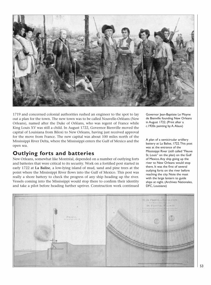
1719 and concerned colonial authorities rushed an engineer to the spot to layout a plan for the town. The new town was to be called Nouvelle-Orléans (NewOrleans), named after the Duke of Orléans, who was regent of France whileKing Louis XV was still a child. In August 1722, Governor Bienville moved thecapital of Louisiana from Biloxi to New Orleans, having just received approvalfor the move from France. The new capital was about 100 miles north of theMississippi River Delta, where the Mississippi enters the Gulf of Mexico and theopen sea.
Outlying forts and batteriesNew Orleans, somewhat like Montréal, depended on a number of outlying fortsand batteries that were critical to its security. Work on a fortified post started inearly 1722 at La Balise, a low-lying island of mud, sand and pine trees at thepoint where the Mississippi River flows into the Gulf of Mexico. This post wasreally a shore battery to check the progress of any ship heading up the river.Vessels coming into the Mississippi would stop there to confirm their identityand take a pilot before heading further upriver. Construction work continued
Governor Jean-Baptiste Le Moynede Bienville founding New Orleansin August 1722. (Print after ac.1920s painting by A. Alaux)
A plan of a semicircular artillerybattery at La Balise, 1722. This postwas at the entrance of theMississippi River (still called “FleuveSt. Louis” on the plan) on the Gulfof Mexico. Any ship going up theriver to New Orleans would stopthere. It was the first of severaloutlying forts on the river beforereaching the city. Note the mastwith the large lantern to guideships at night. (Archives Nationales,DFC, Louisiane)
53
08098 FOR27corre.qxd:08098 FOR27corre.qxd 16/3/09 10:41 Page 53
intermittently for decades thereafter. There were two batteries with barracks forthe detachment of troops, a powder magazine built on pilings to keep it dry,and a protective palisade on the landward side.
As elsewhere on the Mississippi, the great floods of the mighty river with itsstrong current played havoc with such shore fortifications. Except for the twobatteries, which were higher up, the land was often flooded when there werehigh winds. By 1746, La Balise was too silted up and most of its garrison movedto Détour à l’Anglois. Captain Bossu’s impression of the place in 1752 was thatit was “isolated and surrounded by swamps filled with snakes and alligators.”Indeed, La Balise had practically been washed away by the end of the FrenchRegime. British Captain Philip Pittman saw little more than the barracks therein the mid-1760s.
From September 1766, the Spanish administration built a pilot stationslightly to the north on higher ground. In 1803, when French colonial prefectPierre de Laussat saw the pilot station, he noted that it featured “quarters for
54
A plan of the barracks of NewOrleans dated March 30, 1729. Thisside view shows the musket racks.(Archives Nationales, DFC,Louisiane)
A plan of New Orleans, c.1730–31,by which time the town was beingenclosed for the first time by anarrow ditch with a palisade and asmall earthen wall. The powdermagazine (“T”) is shown to thelower left. (Print after a c.1730–31plan in Cable, The Creoles ofLouisiana, 1885)
08098 FOR27corre.qxd:08098 FOR27corre.qxd 16/3/09 10:41 Page 54
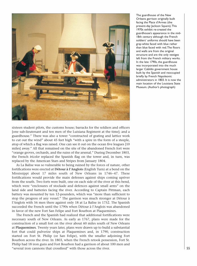
sixteen student pilots, the customs house; barracks for the soldiers and officers[one sub-lieutenant and ten men of the Luisiana Regiment at the time]; and aguardhouse.” There was also a tower “constructed of grating and lattice workto cut out the wind” about 45 feet high “with a spire in the form of a steeple,atop of which a flag was raised. One can see it out on the ocean five leagues [10miles] away.” All that remained on the site of the abandoned French fort were“orange groves, orchards, and the ruins of the arsenal.” During December 1803,the French tricolor replaced the Spanish flag on the tower and, in turn, wasreplaced by the American Stars and Stripes from January 1804.
As La Balise was so vulnerable to being ruined by the forces of nature, otherfortifications were erected at Détour à l’Anglois (English Turn) at a bend on theMississippi about 17 miles south of New Orleans in 1746–47. Thesefortifications would provide the main defenses against ships coming upriverfrom the south. Two forts were built, one on each side of the river at this bend,which were “enclosures of stockade and defences against small arms” on theland side and batteries facing the river. According to Captain Pittman, eachbattery was mounted by ten 12-pounders, which was “more than sufficient tostop the progress of any vessel.” The garrison was much stronger at Détour àl’Anglois with 56 men there against only 18 at La Balise in 1752. The Spanishsucceeded the French until the 1790s when Détour à l’Anglois was abandonedin favor of the new Fort San Felipe and Fort Bourbon at Plaquemines.
The French and the Spanish had realized that additional fortifications werenecessary south of New Orleans. As early as 1767, plans were made for theconstruction of a small fort on the river about 60 miles south of New Orleansat Plaquemines. Twenty years later, plans were drawn up to build a substantialfort that could pulverize ships at Plaquemines and, in 1790, constructionstarted on Fort St. Philip (or San Felipe), with the smaller adjoining FortBourbon across the river. In 1803, when the French retook possession, Fort St.Philip had 18 iron guns and Fort Bourbon had a garrison of about 100 men and“several iron cannons that crossfired” with those across the river. 55
The guardhouse of the NewOrleans garrison originally builtfacing the Place d’Armes (thepresent-day Jackson Square). This1970s exhibit re-created theguardhouse’s appearance in the mid-18th century although the Frenchsoldiers’ uniforms should have beengray-white faced with blue ratherthan blue faced with red. The floorsand walls are from the originalstructure and are the only vestigesleft from the French military works.In the late 1790s, the guardhousewas incorporated into the muchlarger Cabildo government housebuilt by the Spanish and reoccupiedbriefly by French Napoleonicadministrators in 1803. It is now themain location of the Louisiana StateMuseum. (Author’s photograph)
08098 FOR27corre.qxd:08098 FOR27corre.qxd 16/3/09 10:41 Page 55
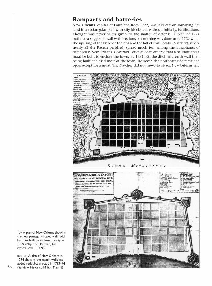
Ramparts and batteriesNew Orleans, capital of Louisiana from 1722, was laid out on low-lying flatland in a rectangular plan with city blocks but without, initially, fortifications.Thought was nevertheless given to the matter of defense. A plan of 1724outlined a suggested wall with bastions but nothing was done until 1729 whenthe uprising of the Natchez Indians and the fall of Fort Rosalie (Natchez), wherenearly all the French perished, spread much fear among the inhabitants ofdefenseless New Orleans. Governor Périer at once ordered that a palisade and amoat be built to enclose the town. By 1731–32, the ditch and earth wall thenbeing built enclosed most of the town. However, the northeast side remainedopen except for a moat. The Natchez did not move to attack New Orleans and
56
TOP A plan of New Orleans showingthe new pentagon-shaped walls withbastions built to enclose the city in1759. (Map from Pittman, ThePresent State..., 1770)
BOTTOM A plan of New Orleans in1794 showing the rebuilt walls andadded redoubts erected in 1793–94.(Servicio Historico Militar, Madrid)
08098 FOR27corre.qxd:08098 FOR27corre.qxd 16/3/09 10:41 Page 56
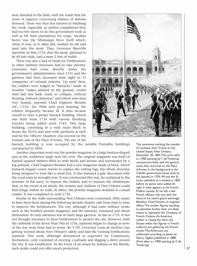
were defeated in the field, with the result that thesense of urgency concerning matters of defenselessened. There was thus less interest in finishingthe work, especially as settlers complained theyhad too few slaves to do this government work aswell as till their plantations for crops. Anotherfactor was the Mississippi River itself which,when it rose, as it often did, washed its silt andsand into the moat. Thus, Governor Bienvillereported, in May 1733, that the moat, planned tobe 60 feet wide, had a mere 2 feet of width.
There was also a lack of funds for fortificationsas other military structures had to take priority.Louisiana had come directly under thegovernment’s administration since 1731 and thegarrison had been increased from eight to 13companies of colonial infantry. Up until then,the soldiers were lodged in “barracks” made ofwooden “stakes planted in the ground, roofedwith bad tree bark, ready to collapse, withoutflooring, without chimneys” and which were thusvery humid, reported Chief Engineer Broutin(AC, C13A, 16). With such poor housing, thesoldiers frequently became ill. It thus becamecrucial to have a proper barrack building, whichwas built from 1734 with various finishingtouches being added until 1743. This largebuilding, consisting of a wide main block tohouse the NCOs and men with pavilions at eachend for the Officers’ Quarters, was erected on thewestern side of the Place d’Armes. The site of thebarrack building is now occupied by the notable Pontalba buildingsconstructed in 1850.
Another important work was the powder magazine in a large bastion-shapedarea at the southwest angle near the river. The original magazine was built offramed squared timbers filled in with bricks and mortar and surrounded by alog palisade. Chief Engineer Broutin had a new magazine made of brick, whichfeatured elegant corner turrets to replace the rotting logs, the whole structurebeing designed to look like a small fort. It also featured a gate decorated withthe royal arms in wrought iron. It was constructed this way, he explained to theminister of the navy, to impress the Indians and to reassure the inhabitantsthat, in the event of an attack, the women and children of New Orleans couldfind refuge within its walls. In effect, the powder magazine doubled as a smallcitadel. It was completed in early 1736.
Insofar as the walls surrounding New Orleans were concerned, little seemsto have been done during the following decades despite calls from time to timeto improve the fortifications. The city, although it had some military workssuch as the fortified powder magazine and the barracks, remained just aboutdefenseless. Its only salvation was its fairly large garrison. As late as 1755, it wasnot thought necessary to have fortifications to protect the city. However, withthe outbreak of the Seven Years War in 1756, opinions began to change as newsof the war went from bad to worse. By 1759, Governor Louis de Kerlérec wasgetting worried about New Orleans’s safety and had the existing fortificationsrepaired. This work, although denounced as expensive by CommissaryRochemore, only consisted of erecting a palisade and digging a ditch aroundthe city. It was insufficient. In the event of an attack by Indians or the British,such works could not offer much protection. 57
The ceremony marking the transferof Louisiana from France to theUnited States, New Orleans,December 20, 1803. This print aftera c.1900 painting by T. de Thulstrupreconstructs fairly well the generalscene that occurred on the Placed’Armes. In the background is theCabildo government house built bythe Spanish in 1795–99 and the St.Louis cathedral as it looked in 1803before its spires were added. Atright is what appears to be FrenchPrefect Laussat. To his left, a fewFrench officers, the one with thehand on his sword guard seeminglyBattalion Chief Vinache, an engineerofficer. The smaller figures standingto attention further back are likelymeant to represent the Company ofFrench Citizens. An Americansoldier is raising the Stars andStripes while two figures in Frenchuniforms are gathering the Frenchtricolor. The Americans areuniformed according to plates byHenry Ogden published in 1888.(Print after a c.1900 painting by T. deThulstrup)
08098 FOR27corre.qxd:08098 FOR27corre.qxd 16/3/09 10:41 Page 57
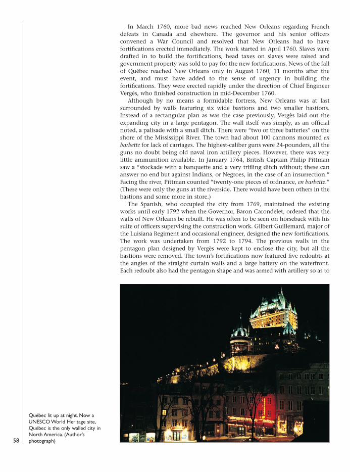
In March 1760, more bad news reached New Orleans regarding Frenchdefeats in Canada and elsewhere. The governor and his senior officersconvened a War Council and resolved that New Orleans had to havefortifications erected immediately. The work started in April 1760. Slaves weredrafted in to build the fortifications, head taxes on slaves were raised andgovernment property was sold to pay for the new fortifications. News of the fallof Québec reached New Orleans only in August 1760, 11 months after theevent, and must have added to the sense of urgency in building thefortifications. They were erected rapidly under the direction of Chief EngineerVergès, who finished construction in mid-December 1760.
Although by no means a formidable fortress, New Orleans was at lastsurrounded by walls featuring six wide bastions and two smaller bastions.Instead of a rectangular plan as was the case previously, Vergès laid out theexpanding city in a large pentagon. The wall itself was simply, as an officialnoted, a palisade with a small ditch. There were “two or three batteries” on theshore of the Mississippi River. The town had about 100 cannons mounted enbarbette for lack of carriages. The highest-caliber guns were 24-pounders, all theguns no doubt being old naval iron artillery pieces. However, there was verylittle ammunition available. In January 1764, British Captain Philip Pittmansaw a “stockade with a banquette and a very trifling ditch without; these cananswer no end but against Indians, or Negroes, in the case of an insurrection.”Facing the river, Pittman counted “twenty-one pieces of ordnance, en barbette.”(These were only the guns at the riverside. There would have been others in thebastions and some more in store.)
The Spanish, who occupied the city from 1769, maintained the existingworks until early 1792 when the Governor, Baron Carondelet, ordered that thewalls of New Orleans be rebuilt. He was often to be seen on horseback with hissuite of officers supervising the construction work. Gilbert Guillemard, major ofthe Luisiana Regiment and occasional engineer, designed the new fortifications.The work was undertaken from 1792 to 1794. The previous walls in thepentagon plan designed by Vergès were kept to enclose the city, but all thebastions were removed. The town’s fortifications now featured five redoubts atthe angles of the straight curtain walls and a large battery on the waterfront.Each redoubt also had the pentagon shape and was armed with artillery so as to
58
Québec lit up at night. Now aUNESCO World Heritage site,Québec is the only walled city inNorth America. (Author’sphotograph)
08098 FOR27corre.qxd:08098 FOR27corre.qxd 16/3/09 10:41 Page 58
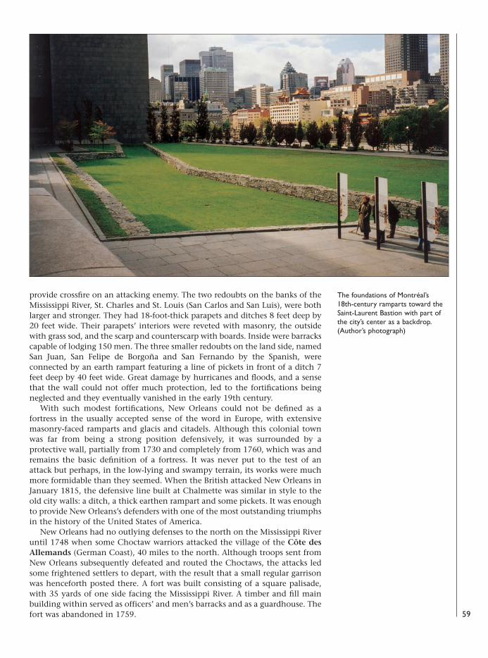
provide crossfire on an attacking enemy. The two redoubts on the banks of theMississippi River, St. Charles and St. Louis (San Carlos and San Luis), were bothlarger and stronger. They had 18-foot-thick parapets and ditches 8 feet deep by20 feet wide. Their parapets’ interiors were reveted with masonry, the outsidewith grass sod, and the scarp and counterscarp with boards. Inside were barrackscapable of lodging 150 men. The three smaller redoubts on the land side, namedSan Juan, San Felipe de Borgoña and San Fernando by the Spanish, wereconnected by an earth rampart featuring a line of pickets in front of a ditch 7feet deep by 40 feet wide. Great damage by hurricanes and floods, and a sensethat the wall could not offer much protection, led to the fortifications beingneglected and they eventually vanished in the early 19th century.
With such modest fortifications, New Orleans could not be defined as afortress in the usually accepted sense of the word in Europe, with extensivemasonry-faced ramparts and glacis and citadels. Although this colonial townwas far from being a strong position defensively, it was surrounded by aprotective wall, partially from 1730 and completely from 1760, which was andremains the basic definition of a fortress. It was never put to the test of anattack but perhaps, in the low-lying and swampy terrain, its works were muchmore formidable than they seemed. When the British attacked New Orleans inJanuary 1815, the defensive line built at Chalmette was similar in style to theold city walls: a ditch, a thick earthen rampart and some pickets. It was enoughto provide New Orleans’s defenders with one of the most outstanding triumphsin the history of the United States of America.
New Orleans had no outlying defenses to the north on the Mississippi Riveruntil 1748 when some Choctaw warriors attacked the village of the Côte desAllemands (German Coast), 40 miles to the north. Although troops sent fromNew Orleans subsequently defeated and routed the Choctaws, the attacks ledsome frightened settlers to depart, with the result that a small regular garrisonwas henceforth posted there. A fort was built consisting of a square palisade,with 35 yards of one side facing the Mississippi River. A timber and fill mainbuilding within served as officers’ and men’s barracks and as a guardhouse. Thefort was abandoned in 1759. 59
The foundations of Montréal’s 18th-century ramparts toward theSaint-Laurent Bastion with part ofthe city’s center as a backdrop.(Author’s photograph)
08098 FOR27corre.qxd:08098 FOR27corre.qxd 16/3/09 10:41 Page 59
Following the cession of Canada to Britain and the American siege of 1775–76,Québec’s fortifications were steadily improved and a large citadel was finallybuilt in the 1820s, thus truly rendering it the “Gibraltar of North America.”Three large forts were also built on the south shore in the 1860s. Following thewithdrawal of the British garrison in 1871, there was pressure to demolish thewalls and batteries. Thanks to the efforts of the heritage-conscious LordDufferin, governor-general of Canada in the 1870s, the ramparts were preservedand today, Québec is the only walled city in North America. The rampart thatwas erected is essentially the same that can be seen in present-day Québec. Sincethe end of the 19th century, Québec has become a favorite destination fortourists and great efforts have been made to preserve the heritage of thisexceptional city. In 1985, UNESCO declared it a World Heritage Site.
After 1760, Montréal’s walls seemed less relevant to a successful defense andmore of an obstacle to businessmen as the city expanded rapidly, there beingtwice as many inhabitants outside its ramparts by the beginning of the 19thcentury. In 1801, legislation authorized the walls’ demolition, which started in1804 and continued until 1817, although most of it had been leveled by 1810.Montréal is now Canada’s second largest city and one of the main businesscenters in the northeast of North America. In the last two decades, small partsof its ramparts’ foundations have been rediscovered and preserved. Thenetwork of outlying forts also fell into ruin and disappeared except for a fewstone vestiges.
At Louisbourg, what had once been a sizeable fortress was reduced to littlemore than a pile of rubble on an abandoned peninsula. Further back in the bay,a fishing village was established and carried on the name of Louisbourg. In thelate 19th century, with the advent of a railroad, tourists started to visit the ratherhaunting and barren area strewn with evocative ruins. In time, it became anational historic site with a small museum. In 1961, over two centuries after thesecond siege, the Government of Canada ordered “The Fortress of Louisbourg isto be reconstructed partially so that future generations can thereby see andunderstand the role of the fortress as a hinge of History. The restoration is to becarried out so that the lessons of History can be animated.” The reconstructionwork was carried out over the next two decades. Incredibly, the fortress town ofLouisbourg lives again today as it was in the mid-18th century!
New Orleans’s earthen ramparts disappeared with the city’s rapid growthfollowing the cession of Louisiana to the United States. Thereafter, theAmericans built strong outlying forts rather than trying to enclose its mostimportant business city and port on the Gulf Coast. Nothing today hints thatNew Orleans’s old and famous “French Quarter,” with its many historicbuildings and jazz halls, was once surrounded by ramparts.
60
The sites today
08098 FOR27corre.qxd:08098 FOR27corre.qxd 16/3/09 10:41 Page 60

ArchivesMyriad maps and plans have been consulted at theNational Archives of Canada, in Ottawa, which holds,as well as originals in its collections, handmade copies,photos (a negative is indicated by a “C” and itsnumber), photostats and photocopies of nearly allknown original examples pertaining to Canada held inother archives. For New France, the vast majority oforiginals are held at the French Archives Nationales,Centre des archives d’outre-mer at Aix-en-Provence inthe Dépôt des Fortifications des Colonies (DFC)section. The colonial correspondence in the Archivesdes Colonies (AC) sections, series B (outward letters),C11A (Canada), C11B (Louisbourg) and C13A(Louisiana) has many useful documents. For SpanishNew Orleans, correspondence in the Papeles de Cubafor the appropriate years as well as maps and plans arepreserved at the Archivo General de Indias in Seville.
Books and articles:Angus, Alexander David, Old Quebec in the days before
our day (Montréal, 1949)Bosworth, Newton, Hochelaga Depicta: the early history
and present state of the city and island of Montreal(Montréal, 1839)
Charbonneau, André, with Desloges, Yvon, andLafrance, Marc, Québec: ville fortifiée (Québec, 1982)The definitive work on Québec’s fortifications.
Fry, Bruce W., An Appearance of Strength: TheFortifications of Louisbourg (Ottawa, 1984; 2volumes)An essential study.
Gauthier, Raymonde, Trois-Rivières disparue, ou presque(Québec, 1978)
Girouard, Désiré, Le vieux Lachine et le massacre du 5août 1689 (Montréal, 1889)
Gonzalez, Julio, Catalogo de Mapas y Planos de laFlorida y la Luisiana en el Archivo General de Indias(Madrid, 1979)
Guide to Louisiana maps and plans.Grant, George Monro, Picturesque Canada; the country
as it was and is (Toronto, 1882; 2 volumes) Hinshelwood, N.M., Montreal and Viscinity (Montréal,
1903)Laussat, Pierre Clément de, Memoirs of my Life (Baton
Rouge, 1977)Lemoine, Louis, Le château fort de Longueuil
(Longueuil, 1987)McDermott, John Francis (ed.), Frenchmen and French
Ways in the Mississippi Valley (Urbana, 1969)
McLennan, Stewart, Louisbourg: From its Foundation toits Fall 1713–1758 (London, 1918)
Montréal, ville fortifiée au XVIIIe siècle (Montréal, 1992)Studies by several authors. An essential source.
Noppen, Luc, with Paulette, Claude and Tremblay,Michel, Québec: trois siècles d’architecture(Montréal, 1979)
Parker, Gilbert, and Bryan, Claude G., Old Quebec(New York, 1903)
Québec: ville et capitale (Sainte-Foy, 2001)Studies by several authors. An essential source.
Robert, Jean-Claude, Atlas historique de Montréal(Montréal, 1994)Essential for maps and plans.
Robinson, Willard B., “Maritime FrontierEngineering: the Defense of New Orleans” inLouisiana History (winter 1977)An essential study.
Vidal, Laurent and d’Orgeix, Emilie (ed.), Les villesfrançaises du Nouveau Monde (Paris, 1998)
Wilson, Samuel, Jr., “Gulf Coast Architecture” inSpain and her Rivals on the Gulf Coast (Pensacola,1971)Good overview; well illustrated.
61
Select bibliography
08098 FOR27corre.qxd:08098 FOR27corre.qxd 16/3/09 10:41 Page 61
abbatis A defensive barricade or row of obstructions madeup of closely spaced felled trees, their tops toward theenemy, their branches trimmed to points and interlacedwhere possible.
banquette A continuous step or ledge at the interior baseof a parapet on which defenders stood to direct musketfire over the top of the wall. A fire step.
barbette Said of cannons placed over a rampart withoutthe protective embrasures.
bastion A projection in the enceinte, made up of four sides(two faces and two flanks), which better enabled agarrison to defend the ground adjacent to the main orcurtain walls.
battery An emplacement for artillery. breastwork See parapet.casemate A mortar-bomb or shell-proof chamber located
within the walls of defensive works; generally piercedwith openings for weapons; loopholes for muskets orembrasures for cannon.
cavalier A raised construction, usually in a fortress, holding asecond tier of guns in a battery.
citadel A strong fort within (or a part of) a largerfortification. No true citadels were built in New France.
cordon The coping or top course of a scarp or a rampart,sometimes of different-colored stone and set proud fromthe rest of the wall. The point where a rampart stopsand a parapet starts.
counterguard A defensive work built in a ditch in front of abastion to give it better protection.
covered way A depression, road or path in the outer edge of afort’s moat or ditch, generally protected from enemy fireby a parapet, at the foot of which might be a banquetteenabling the coverage of the glacis with musketry.
cunette A furrow located in the bottom of a dry ditch forthe purpose of drainage.
curtain The wall of a fort between two bastions.demi-bastion A half-bastion with only one face and one flank.demi-lune A triangular-shaped defensive work built in a
ditch in front of a bastion or a curtain wall.ditch A wide, deep trench around a defensive work. When
filled with water it was termed a moat or wet ditch;otherwise a dry ditch or foss.
embrasure An opening in a wall or parapet allowingcannon to fire through it, the gunners remaining undercover. The sides of the embrasure were called cheeks, thebottom was the sole, the narrow part of the opening wasthe throat and the wide part was the splay.
en barbette An arrangement for cannon to be fired directlyover the top of a low wall instead of through embrasures.
enfilade fire Fire directed from the flank or side of a body
of troops, or along the length of a ditch, parapet orwall. Guns in the flank of a bastion can direct enfiladefire along the face of the curtain.
epaulement A parapet or work protecting againstenfilade fire.
fascines Long bundles of sticks or small-diameter treebranches bound together for use in revetments, forstabilizing earthworks, filling ditches, etc.
fossé or foss See under ditch.fraise A defense of closely placed stakes or logs, 6–8 feet
long, driven or dug into the ground and sharpened;arranged to point horizontally or obliquely outward froma defensive position.
gabion A large, round, woven wicker cylinder intended to beset in place and filled with earth, sand or stones.
gallery An interior passageway or corridor that ran alongthe base of a fort’s walls.
gate A main entrance of a fortress.glacis A broad, gently sloped earthwork or natural slope in
front of a fort, separated from the fort proper by a ditchand outworks and so arranged as to be swept withmusket or cannon fire.
gorge The interval or space between the two curtain anglesof a bastion. In a ravelin, the area formed by the flankedangle and either left open or enclosed.
guardhouse The headquarters for the daily guard. guérite A small lookout watch tower, usually located on the
upper outer corner of a bastion.half bastion See demi-bastion.hornwork A work made up of a bastion front; two half-
bastions and a curtain and two long sides termed“branches.” It functioned to enclose an area immediatelyadjacent to a fort or citadel and create another layer ofdefense. None were built in New France’s fortresses.
loopholes Small openings in walls or stockades throughwhich muskets were fired.
magazine A place for the storage of gunpowder, arms orgoods generally related to ordnance.
merlon The solid feature between embrasures in a parapet.moat See ditch.orgue See portcullis.outwork An outer defense, inside the glacis but outside the
body of the place. A ravelin is an outwork.palisade A high fence made of stakes, poles, palings, or
pickets, supported by rails and set endwise in the groundfrom six to nine inches apart. See stockade.
parapet A breastwork or protective wall over whichdefenders, standing on banquettes, fired their weapons.The parapet was usually built on top of the fort’srampart.62
Glossary
08098 FOR27corre.qxd:08098 FOR27corre.qxd 16/3/09 10:41 Page 62
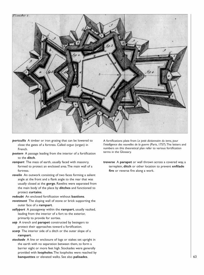
portcullis A timber or iron grating that can be lowered toclose the gates of a fortress. Called orgue (organ) inFrench.
postern A passage leading from the interior of a fortificationto the ditch.
rampart The mass of earth, usually faced with masonry,formed to protect an enclosed area. The main wall of afortress.
ravelin An outwork consisting of two faces forming a salientangle at the front and a flank angle to the rear that wasusually closed at the gorge. Ravelins were separated fromthe main body of the place by ditches and functioned toprotect curtains.
redoubt An enclosed fortification without bastions.revetment The sloping wall of stone or brick supporting the
outer face of a rampart. sallyport A passageway within the rampart, usually vaulted,
leading from the interior of a fort to the exterior,primarily to provide for sorties.
sap A trench and parapet constructed by besiegers toprotect their approaches toward a fortification.
scarp The interior side of a ditch or the outer slope of arampart.
stockade A line or enclosure of logs or stakes set upright inthe earth with no separation between them, to form abarrier eight or more feet high. Stockades were generallyprovided with loopholes. The loopholes were reached bybanquettes or elevated walks. See also palisades.
traverse A parapet or wall thrown across a covered way, aterreplein, ditch or other location to prevent enfiladefire or reverse fire along a work.
63
A fortifications plate from Le petit dictionnaire du tems, pourl’intelligence des nouvelles de la guerre (Paris, 1757). The letters andnumbers on this theoretical plan refer to various fortificationterms in the Glossary.
08098 FOR27corre.qxd:08098 FOR27corre.qxd 16/3/09 10:41 Page 63
64
Figures in bold refer to illustrations
Acadia 4, 45Amherst, General Jeffery 44, 51Angus, Alexander D. 41Arnold, General Benedict 41
Bastide, Colonel 51Beaucours, Josué Berthelot de 9, 20, 24, 36Belmont, Father de 39, 40Bienville, Jean-Baptiste Le Moyne 52, 53, 53, 57Boispinel, Pinel de 9Boucher, Captain Pierre 31Bougainville, Louis-Antoine de 24Bourdon, Jacques 9, 32Broutin, Chief Engineer 9, 10, 57
Carondelet, Baron 58Cartier, Jacques 11Champlain, Samuel de 11–12, 30Chaussegros de Léry, Gaspard 9, 10, 21, 24, 36Coehorn, Menno van 8Colbert, Jean-Baptiste 13Côte des Allemands 59
d’Anville, Duke 48d’Asfeld, Marquis 9de La Morandière, Sub-Engineer 43Détour à l’Anglois 54, 55Dollard des Ormeaux, Adam 41du Verger de Verville, Joseph-François 9Dufferin, Lord 60Duplessis, Pacifique 30
Forges du Saint-Maurice 31Fort Boucherville 42Fort Bourbon 55Fort Carillon 10Fort Contrecoeur 42Fort Côte Saint-Jean 42Fort Cuillerier 40Fort de Chartres 10Fort de la Longue-Pointe 42Fort de la Montagne 37, 38, 39–40, 42Fort de la Rivière-des-Prairies 41–42Fort Lachine (aka Verdun, Rémy) 40–41, 42Fort Laprairie 43Fort Le Tremblay 42Fort Longueuil 37, 39, 42–43Fort Nouvelle Lorette 41, 44Fort Pointe-aux-Trembles 42Fort Présentation 40Fort Rolland 40Fort Saint-Lambert 43Fort Sainte-Anne 41Fort Sainte-Geneviève 41Fort Sainte-Marie 42Fort Sainte-Thérèse 42Fort San Felipe 55Fort Sault-Saint-Louis 43Fort Senneville 38, 41, 43, 44Fort Varennes 42Fort Verchères 42France
colonization of North America 4
military engineering 8–10royal coat of arms 6
France-Roy 11, 11Franquet, Louis 9, 31Frontenac, Louis de Buade, Comte de 13, 16–17,
19–20, 41, 42
Guillemard, Gilbert 58
Huault de Montmagny, Jacques 12–13
Ingénieurs du Rois (King’s Engineers) 6, 9, 10Isle Royale (Cape Breton Island) 4, 6, 45
Kerlérec, Louis de 57Kirke brothers 12
La Balise 53–54, 53La Salle, Robert Cavelier de 40, 52, 52Laussat, Pierre de 54–55Le Ber, Jacque 41Le Blond de la Tour, Jacques 9Le Moyne, Charles 42, 43Le Petit Fort Gervais 42Levasseur de Néré, Jacques 9, 20Lévis, General 28, 29, 44Lhermitte, Jacques de 9Louis XIV 8, 15, 43Louis XV 45, 53Louisbourg
bastions 47–48batteries 47, 48, 48, 49design 47fortifications 46, 50harbor 45, 47, 51Lighthouse Point 48, 49, 51reconstruction 49sieges 48–49, 51today 60views of 45
Louisiana 4, 52
Mackellar, Patrick 28, 29Maisonneuve, Paul Chomedey de 32military engineering 8–10Montcalm, Louis Joseph, Marquis de 24, 25–26, 28,
43Montmorency Falls 28Montmorency River 25, 27Montréal
design 10establishment of 32–33fall of (1760) 44fortifications (1760) 34outlying forts 35, 37–43palisades 33plans 33, 36ramparts 33, 36-37today 59, 60views of 36, 37walls 33
Murray, Brigadier-General James 28–29
New Biloxi 52, 53New France (La Nouvelle-France) 4–5, 5, 6
IndexNew Orleans
barracks 54fortifications 56–59guardhouse 55outlying forts 53–55plans 54, 56today 60transfer to USA 57
Paugé, Adrien de 9Perrier, Paul de 9Phips, Sir William 13, 15–17, 19Pittman, Captain Philip 54, 55, 58Placentia, Newfoundland 4, 45Plaquemines 55Pontleroy, Nicolas Sarrebrousse de 9, 24, 25
QuébecAnse-aux-Foulon 26, 28Beauport shore 17, 19, 25, 26, 27Cap Rouge 11Cape Diamond 11, 12, 20, 21, 27Château Saint-Louis 12, 13Citadel 29Dauphine Redoubt 21, 24design 10du Clergé battery 24fortifications 14, 15, 19, 20, 22–23Habitation 11–12, 12, 13La Diable 25La Genouillère battery 24landward defences (1759) 25Nouvelle Casernes (New Barracks) 24Plains of Abraham 13, 28plans 21ramparts 20, 24Royal Battery 18, 19Royale Redoubt 21, 27Sainte-Foy 29Sault Redoubt 26sieges 15–19, 16, 17, 24–28, 27, 28–29today 25, 58, 60views of 17, 20, 28Walker’s attempted capture of (1711)
20–21
Roberval, Sieur de 11
St. Charles River 17, 24Saint-Frédéric 10, 21Schuyler, Major Peter 43Sulpician Order 39
Trois-Rivières 5-6, 30–31, 30, 31
Vauban, Sébastien Le Preste de 8–10, 47Vaudreuil, Governor-General 24Vergès, Chief Engineer 58Verrier, Étienne 9, 10Ville-Marie 32, 32Villeneuve, Robert de 9Violette, Louis de La 30
Walker, Admiral Hoveden 20–21Wolfe, General James 27–28, 51
08098 FOR27corre.qxd:08098 FOR27corre.qxd 16/3/09 10:41 Page 64
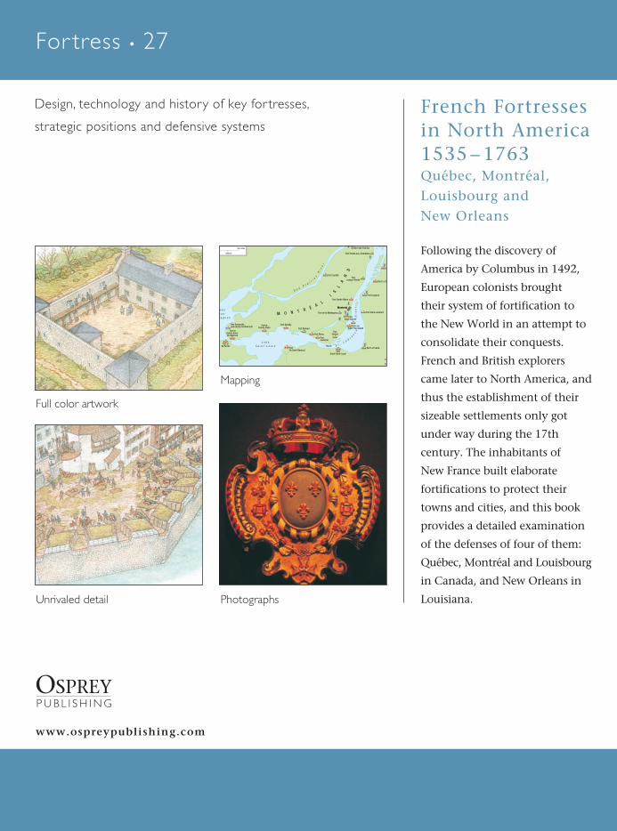
René C
hartrandFren
ch Fo
rtresses in N
orth
Am
erica 15
35
–1
76
3
OSPREYP U B L I S H I N G
Following the discovery of
America by Columbus in 1492,
European colonists brought
their system of fortification to
the New World in an attempt to
consolidate their conquests.
French and British explorers
came later to North America, and
thus the establishment of their
sizeable settlements only got
under way during the 17th
century. The inhabitants of
New France built elaborate
fortifications to protect their
towns and cities, and this book
provides a detailed examination
of the defenses of four of them:
Québec, Montréal and Louisbourg
in Canada, and New Orleans in
Louisiana.
www.ospreypublishing.com
Full color artwork
Photographs
a k ee u x -t a g n e s
L a k eS a i n t - L o u i s
Fort atSainte-Anne-de-Bellevue
Fort atIle Perrot
Fort Sennevilleand nearby fortified mill
Fort atPointe-Claire
Fort Gentilly
Fort Rolland
FortSault-Saint-Louis
Fort La Prairie
Fort RémyFortCuillerier
FortVerdun
FortIle Saint-Bernard
Fort Saint-Lambert
Forts onSaint-Paul Island
Fort de la Montagne
FortSaint-Gabriel
Montréal
FortLongue-Pointe
Fort Sainte-Marie
Fort Longeuil
Fort Le Tre
F
Fort Pointe-aux-Trembles
FortRivière-des-Pariries
Fort Lorette
D e sP r a i r i e
sR
iv
er
S t .L a w
r en
c
eR
iv
er
M O N T R ÉA
L
I
SL
AN
DRapids
500 miles
500 km
Mapping
Unrivaled detail
French Fortresses in North America 1535–1763Québec, Montréal, Louisbourg and New Orleans
For tress • 27
Fortress
• 27
Design, technology and history of key for tresses,
strategic positions and defensive systems
For tress
French Fortressesin North America1535 – 1763Québec, Montréal,Louisbourg and New Orleans
OSPREYP U B L I S H I N G
René Char trand • Illustrated by Donato Spedaliere
OSPR
EYFOR27coverUK.qxd:FOR27coverUK.qxd 11/3/09 15:52 Page 1