Embed Size (px)
Citation preview

57 IL6b
). 101
flU^S^^^M
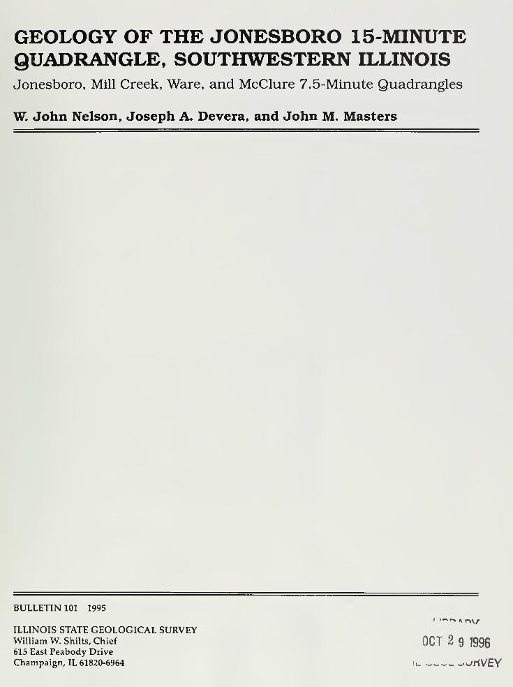
u^w^OGY OF THE JONESBORO 15-MINUTEQUADRANGLE, SOUTHWESTERN ILLINOISJonesboro, Mill Creek, Ware, and McClure 7.5-Minute Quadrangles
W. John Nelson, Joseph A. Devera, and John M. Masters
Department of Natural Resources
ILLINOIS STATE GEOLOGICAL SURVEY
BULLETIN 101 1995OCT % 9 1996

LIBRARY.
GEOLOGY OF THE JONESBORO 15-MINUTEQUADRANGLE, SOUTHWESTERN ILLINOISJonesboro, Mill Creek, Ware, and McClure 7.5-Minute Quadrangles
W. John Nelson, Joseph A. Devera, and John M. Masters
BULLETIN 101 1995
» -» «^ a n\fILLINOIS STATE GEOLOGICAL SURVEYWilliam W. Shilts, Chief OCT 2 9 799g615 East Peabody Drive
Champaign, IL 61820-6964 I u ~ ^ ~^ ^ otiVE
Y
ACKNOWLEDGMENTSThis study was supported by the U.S. Geological Survey, Department of the
Interior, under Assistance Award No. 14-08-0001 -A0891. Additional funding
was provided by the State of Illinois under the State Geologic Mapping Initia-
tive. Many ideas on the nature and origin of tripoli were gained through dis-
cussions with Richard B. Berg, and Richard W. Harrison provided valuable
insights on the structural geology and tectonic history from his work in the
adjacent Thebes Quadrangle. Dennis R. Kolata and Heinz H. Dambergerreviewed the manuscript and provided many helpful comments; technical
editing was performed by Bob Wathen, and figures were drafted by Vicki
Rinehart. We thank the numerous landowners who allowed us access to their
lands for geologic mapping. Special thanks are in order for Harley Rhodes,
Harold E. Dillow, Karol L. Hunter, Kenneth D. Rosson, and Clifton More-land, who allowed us to drill stratigraphic test holes on their property. Karl L.
Bartlesmeyer, Bill Stout, Jr., and Dave Eddings of the Illinois Department of
Transportation excavated a roadcut for us without charge in an attempt to
expose the Iron Mountain Fault.
ILLINOIS
°""""ment Q' Printed by authority of the State of'Illinois/1995/1200
resources ®printed with soybean ink on recycled paper

CONTENTS
ACKNOWLEDGMENTS
ABSTRACT 1
SUMMARY 3
INTRODUCTION 5
Purpose 5
Location and Physiography 5
Geologic Setting 5
Previous Studies 5
Methodology 6
STRATIGRAPHY 7
Mt. Simon (Lamotte) Sandstone 7
Knox Group 7
Everton Formation 7
St. Peter Sandstone 7
Dutchtown Formation 7
Joachim Dolomite 8
"Pecatonica Formation" 8
Plattin Limestone 8
Decorah Formation 9
Kimmswick Limestone 9
Cape Limestone 9
Maquoketa Formation 10
Cape La Croix Shale Member 10
Thebes Sandstone Member 10
Orchard Creek Shale Member 10
Girardeau Limestone Member 11
Leemon Formation 11
Sexton Creek Limestone 11
Bainbridge Formation 12
Seventy-Six Shale Member 12
St. Clair Limestone Member 12
Moccasin Springs Member 14
Bailey Limestone 14
Grassy Knob Chert 15
Clear Creek Formation 15
Unaltered lithology 16
Altered lithology 16
Grand Tower Limestone 19
Dutch Creek Sandstone Member 19
Unnamed limestone member 19
St. Laurent Formation 20
Unaltered lithology 20Altered lithology 21
New Albany Shale 21
Chouteau Limestone 24Springville Shale 24
State Pond Member 25Upper member 25Altered lithology 26
Fort Payne Formation 26Unaltered lithology 26
Altered lithology 27Ullin Limestone 28Salem Limestone 29St. Louis Limestone 30Ste. Genevieve Limestone 30Pope Group 31
Cretaceous System 32Tuscaloosa Formation (?) 32McNairy Formation 32
Tertiary System 33Wilcox Formation (?) 33
Quaternary System 34
Upland silt and colluvium 34
Alluvial and lacustrine deposits 34
STRUCTURAL GEOLOGY 35
Eastern Homoclinal Area 35
Western Homoclinal Area 35
Harrison Creek Anticline 35
Major Faults 35
Atwood Fault 35
Delta Fault 37
Cape Road Fault 37
"Thumb Area" 38
Altered Area 38
Extent 39
Nature of alteration 39
Faults 39
Folds 41
Joints and clastic dikes 41
Causes of alteration 42
Post-Cretaceous Faulting 44
Summary 46
GEOLOGIC HISTORY 47
Ordovician 47
Silurian 47
Devonian 47
Mississippian 48
Late Mississippian through Early Cretaceous 48
Cretaceous and Tertiary 48
ECONOMIC GEOLOGY 50
Silica 50
Limestone 51
Clay and Shale 51
Oil and Gas 51
Fluorite and Metallic Ores 52
REFERENCES 54
FIGURES1 Location map, showing study area (shaded), adjacent quadrangles,
and major structural features 4
2 Stratigraphic column, showing Middle and Upper Ordovician units
(except Leemon Formation) in the study area 6
3 Sexton Creek Limestone and St. Clair Limestone Member of
Bainbridge Formation, north of the mouth of Dongola Hollow 12
4 Sexton Creek Limestone, showing the numerous closely fractured
chert layers 13
5 Stratigraphic column, showing Silurian and Devonian units in the
study area 13
6 Man-made exposure of the Clear Creek Formation 16

7 Abandoned underground silica mine in white tripoli of Clear Creek
Formation 17
8 Ledge-forming chert of Clear Creek Formation 18
9 Contact of Dutch Creek Sandstone (above) to Clear Creek Formation 18
10 Brecciated Dutch Creek Sandstone, consisting of angular sandstone
clasts cemented by silica and iron oxide 19
1
1
Chart showing development of lithostratigraphic classification of
Middle and Upper Devonian strata in southwestern Illinois 20
12 Graphic columns illustrating the lithologic variability of the
St. Laurent Formation in and near the study area 22
13 Isopach map of New Albany Shale 24
14 Tsopach map of Springville Shale 25
15 Basal Fort Payne Formation and upper Springville Shale in the
altered area 26
16 Siliceous limestone of the Fort Payne Formation cropping out north
of Lingle Creek 27
17 Isopach map of Fort Payne Formation 28
18 Crosslaminated Ullin Limestone (Jonesboro Quarry), showing the
typical "speckled" appearance of the limestone 29
19 Large-scale planar crossbedding in upper Ullin Limestone at the
Columbia Quarry Company's Jonesboro Quarry 29
20 Stratigraphic column showing Mississippian units of the study area 31
21 Steeply dipping Cretaceous-Tertiary sand and gravel 32
22 Map showing structural features of the study area and distribution
of Cretaceous-Tertiary strata 36
23 Megabreccia, composed of blocks of altered Springville Shale andSt. Laurent Formation in a soft claylike matrix 38
24 Profile of fault zone along an east-trending ravine 39
25 Faults on the north-facing wall of Lone Star Cement Company'sopen-pit silica mine 40
26 Sketch of fault and kink fold exposed in the bank of a creek 41
27 Sketch of a fault in the southwest bank of Johnson Creek 41
28 Anticline in the Springville Shale 42
29 Tight chevron fold in shale and siltstone of the St. Laurent
Formation in You-Be-Damned Hollow 42
30 Fault in the Springville Shale 43
31 Fissure (2 ft wide) in Clear Creek Formation 43
32 Fault zone in south bank of Cooper Creek 44
33 Fault at the portal of an abandoned ganister mine near Elco 45
34 Small fault displacing Cretaceous-Tertiary sand and gravel 45
35 Twin "chaser" grinding mills of an abandoned silica plant 50
36 A sample of mammillary manganese dioxide from the St. Laurent
Formation near the Delta Fault 53
TABLES1 Thicknesses and lithologies of formations in the Knox Group in the
Humble no. 1 Pickel well 8
2 Significant boreholes in the study area 52

Digitized by the Internet Archive
in 2012 with funding from
University of Illinois Urbana-Champaign
http://archive.org/details/geologyofjonesbo101deve
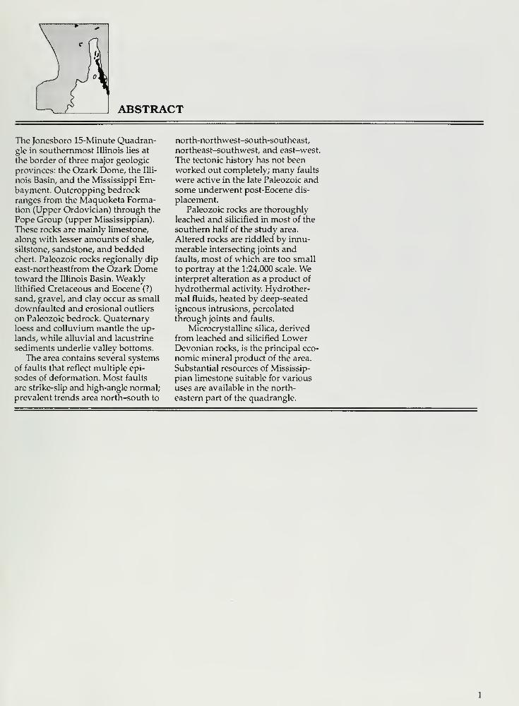
ABSTRACT
The Jonesboro 15-Minute Quadran-gle in southernmost Illinois lies at
the border of three major geologic
provinces: the Ozark Dome, the Illi-
nois Basin, and the Mississippi Em-bayment. Outcropping bedrockranges from the Maquoketa Forma-tion (Upper Ordovician) through the
Pope Group (upper Mississippian).
These rocks are mainly limestone,
along with lesser amounts of shale,
siltstone, sandstone, and beddedchert. Paleozoic rocks regionally dip
east-northeastfrom the Ozark Dometoward the Illinois Basin. Weaklylithified Cretaceous and Eocene (?)
sand, gravel, and clay occur as small
downfaulted and erosional outliers
on Paleozoic bedrock. Quaternaryloess and colluvium mantle the up-lands, while alluvial and lacustrine
sediments underlie valley bottoms.
The area contains several systems
of faults that reflect multiple epi-
sodes of deformation. Most faults
are strike-slip and high-angle normal;
prevalent trends area north-south to
north-northwest-south-southeast,
northeast-southwest, and east-west.
The tectonic history has not beenworked out completely; many faults
were active in the late Paleozoic andsome underwent post-Eocene dis-
placement.
Paleozoic rocks are thoroughly
leached and silicified in most of the
southern half of the study area.
Altered rocks are riddled by innu-
merable intersecting joints andfaults, most of which are too small
to portray at the 1:24,000 scale. Weinterpret alteration as a product of
hydrothermal activity. Hydrother-
mal fluids, heated by deep-seated
igneous intrusions, percolated
through joints and faults.
Microcrystalline silica, derived
from leached and silicified LowerDevonian rocks, is the principal eco-
nomic mineral product of the area.
Substantial resources of Mississip-
pian limestone suitable for various
uses are available in the north-
eastern part of the quadrangle.

5 *
V d^
>? "ftijflWif-
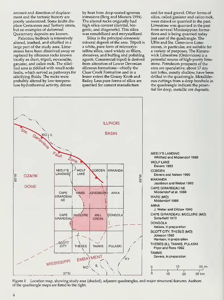
Faults apparently controlled selective silicification of rocks in the study area, as illustrated by this outcrop of highly silicified
Clear Creek Formation (Lower Devonian) along a northeast-trending fault. (View is directed to the noartheast.) Beddingstrikes northeast and dips northwest. Originally a cherty limestone, the Clear Creek was totally converted to chert and trip-
oli in this area. Location is SW NW SW, Sec. 14, T14S, R2W, Mill Creek 7.5-Minute Quadrangle.

SUMMARY
The Jonesboro 15-Minute Quadran-gle is situated in southernmost Illi-
nois along the Mississippi River. It
encompasses parts of three major
geologic provinces: the OzarkDome, the Illinois Basin, and the
Mississippi Embayment. The OzarkDome section on the west features
rugged uplands underlain by Ordo-
vician through Devonian bedrock.
The Illinois Basin section, in the
northeast corner of the quadrangle,
is rolling upland having karst topog-
raphy commonly developed in Mis-
sissippian limestone bedrock. TheMississippi Embayment section in
the southeast corner is represented
by nearly level Quaternary flood-
plain deposits in the Cache Valley.
The broad floodplain of the Missis-
sippi River crosses the east flank of
the Ozark Dome along the west
edge of the study area.
Cambrian and Ordovician rocks
of the Jonesboro Quadrangle are
known principally from borehole
data. The oldest unit penetrated bydrilling is the Upper Cambrian Mt.
Simon (Lamotte) Sandstone. This is
overlain by more than 6,500 feet of
cherty, sandy dolomite of the KnoxGroup (Upper Cambrian and LowerOrdovician). Middle Ordovician
rocks comprise the following: the
Everton Formation at the base, 240
feet of sandy dolomite; the St. Peter
Sandstone, about 45 feet of quartz
arenite; the Dutchtown Formation,
200 to 360 feet of petroliferous lime-
stone and dolomite; the JoachimDolomite, about 230 feet thick; the
"Pecatonica" and Plattin Forma-tions, 525 to 700 feet of mostly dark,
micritic limestone; the Decorah For-
mation, 40 to 60 feet of argillaceous
limestone and shale; and the Kimms-wick Limestone, 115 to 160 feet of
white, coarsely crinoidal, high-
calcium limestone. The MaquoketaFormation of Cincinnatian (Late
Ordovician) age is the oldest unit ex-
posed in the Jonesboro Quadrangle.The Maquoketa comprises 140 to
200 feet of shale, siltstone, sand-
stone, and limestone. It represents
two upward-shoaling cycles, with
siliciclastics derived from both a dis-
tant eastern source and a nearby
western source on the Ozark Dome.Silurian strata include the Sexton
Creek Limestone (30 to 40 feet of
cherty limestone) and the Bain-
bridge Formation (120 to 180 feet of
limestone, marlstone, and red to
green calcareous shale). These rocks
apparently were deposited in tec-
tonically stable, quiet-water marinesettings. The Silurian-Devonian
boundary lies in the lower part of
the Bailey Limestone, which overlies
the Bainbridge.
Lower Devonian rocks include
most of the Bailey Limestone, the
Grassy Knob Chert, and the Clear
Creek Formation. These three forma-
tions consist of light-colored, mi-
critic to fine grained, cherty,
siliceous limestone and beddedchert. They total 750 to 900 feet
thick. Conditions of sedimentation
are not well established, but the
Bailey and Grassy Knob seem to re-
cord gradual deepening, and the
Clear Creek gradual shoaling, of a
sea where much biogenic silica wasproduced. The east flank of the
Ozark Dome rose and periodically
shed siliciclastics eastward during
Middle and Late Devonian time.
Middle and Upper Devonian rocks
progressively thin and are truncated
westward onto the flank of the
dome. These strata include the Mid-dle Devonian Grand Tower Lime-stone (skeletal limestone and quartz
sandstone 10 to 125 feet thick) andSt. Laurent Formation (cherty car-
bonates, shale, and siltstone 60 to
200 feet thick) and the Upper Devo-nian New Albany Shale (black shale,
where present, up to 80 feet thick).
During Mississippian time the
Ozark Dome was still a positive
area, but it did not shed sediment to
the study area. The Springville Shale
(lower Valmeyeran) is an upward-coarsening prodeltaic wedge (distal
Borden delta) probably derived from
a distant eastern source area. TheFort Payne Formation, fine grained
siliceous limestone and beddedchert 10 to 140 feet thick, disconform-
ably overlies the Springville. Theoverlying Ullin, Salem, St. Louis,
and Ste. Genevieve Limestones are a
laterally intergrading succession of
shallow-water limestones about
1,000 to 1,250 feet thick. The young-est Paleozoic rocks in the quadran-gle are intertonguing limestones,
shales, and sandstones of the PopeGroup (upper Valmeyeran to lowerChesterian Series).
Cretaceous and Eocene (?) sedi-
ments occur as scattered hilltop out-
liers and along a discontinuous
north-trending belt in the eastern
part of the quadrangle. The belt is in-
terpreted as a fault-controlled pale-
ovalley. Deposits are tentatively
assigned to the Upper Cretaceous
Tuscaloosa Formation (light-colored
chert gravel), the Upper CretaceousMcNairy Formation (brightly col-
ored sand, silt and clay, with lenses
of white quartz arenite and conglom-erate), and the Eocene Wilcox Forma-tion (?) (sand and gravel with grayto black, rounded chert pebbles). All
of these appear to be fluvial andoverbank sediments, except
McNairy quartz arenite, which prob-
ably is a marine shoreface deposit.
Structure of the quadrangle is
complex. The regional dip is ENE,into the Illinois Basin. The north-
trending Harrison Creek Anticline
probably overlies a basement fault.
The Atwood and Delta Faults andseveral smaller faults that strike
NNW are high-angle normal faults.
Innumerable smaller faults occur in
the southern Jonesboro 7.5-Minute
Quadrangle and through most of the
Mill Creek Quadrangle. The mostcommon trends are north-south,
north-northwest-south-southeast,
east-west, and northeast-southwest.
Many of these faults show features
indicative of strike-slip, such as hori-
zontal slickensides, "flower struc-
tures," and pull-apart grabens. The
amount and direction of displace-
ment and the tectonic history are
poorly understood. Some faults dis-
place Cretaceous and Tertiary strata,
but no examples of deformedQuaternary deposits are known.
Paleozoic bedrock is intensively
altered, leached, and silicified in a
large part of the study area. Lime-stones have been dissolved away or
replaced by siliceous rocks knownlocally as chert, tripoli, novaculite,
ganister, and calico rock. The silici-
fied area is riddled with small-scale
faults, which served as pathways for
silicifying fluids. The rocks wereprobably altered by low-tempera-
ture hydrothermal activity, driven
by heat from deep-seated igneous
intrusions (Berg and Masters 1994).
The altered rocks originally hadhigh silica content (detrital, bio-
genic, and diagenetic). This silica
was remobilized and recrystallized.
Silica is the principal economicmineral deposit of the area. Tripoli is
a white, pure form of microcrys-
talline silica, used widely as fillers,
abrasives, and buffing and polishing
agents. Commercial tripoli is derived
from alteration of Lower Devoniansiliceous formations—chiefly the
Clear Creek Formation and to a
lesser extent the Grassy Knob andBailey. Less pure forms of silica are
quarried for cement manufacture
and for road gravel. Other forms of
silica, called ganister and calico rock,
were mined or quarried in the past.
Limestone was quarried in the past
from several Mississippian forma-tions and is being quarried todayjust east of the quadrangle. TheUllin and Ste. Genevieve Lime-stones, in particular, are suitable for
a variety of purposes. The Kimms-wick Limestone (Ordovician) is a
potential source of high-purity lime-
stone. Petroleum prospects of the
area are speculative; about 17 dry
test holes, mostly shallow, have beendrilled in the quadrangle. Metallifer-
ous cuttings from a deep borehole in
the quadrangle indicate the poten-
tial for deep, metallic ore deposits.
ILLINOIS
BASIN
OZARK
DOME
:OBDEN MAKANDA
CAPEGIRARDEAU \
NE
WARE JONESBORO ANNA
CAPE/
McCLUREGIRARDEAU'
.SCOTTCITY
\THEBES
\
MILL
CREEKCONGOLA
/
TAMMS PULASKI
/
/
/
eMBaymentMISSISSIPPI
BM( ^
37^N \ ) \
/KY/
NEELY'S LANDINGWhitfield and Middendorf 1988
WOLF LAKEDevera 1993
COBDENDevera and Nelson 1 995
MAKANDAJacobson and Weibel 1993
CAPE GIRARDEAU NEMiddendorf et al. 1988
WARE (MO)Middendorf 1989
ANNAJ. Weller and Ekblaw 1940
CAPE GIRARDEAU, McCLURE (MO)Satterfield 1973
DONGOLANelson, in preparation
SCOTT CITY, THEBES (MO)Johnson 1 985Harrison, in preparation
THEBES (IL), TAMMS, PULASKIPryor and Ross 1 962
TAMMSDevera, in preparation
r- 1^
10
10_L_
"T~20
20 mi^ l
Figure 1 Location map, showing study area (shaded), adjacent quadrangles,
of the quadrangle maps are listed to the right.
30 km
and major structural features. Authors

INTRODUCTION
PurposeThis report accompanies geologic
maps of the Jonesboro and Ware(Nelson and Devera, 1994) and Mill
Creek and McClure (Devera et al.
1994) 7.5-Minute Quadrangles. These
quadrangles were mapped under
the Cooperative Geologic Mapping(COGEOMAP) program, a joint ef-
fort of the U.S. Geological Survey
(USGS) and the Illinois State Geo-logical Survey (ISGS).
The Jonesboro 15-Minute Quad-rangle lies in a key area geologically.
Parts of three major geologic prov-
inces—the Ozark Dome, the Illinois
Basin, and the Mississippi Embay-ment—fall within the study area
(fig. 1). Ordovician through Missis-
sippian bedrock crops out in this
quadrangle, as do Cretaceous andTertiary strata. The quadrangle lies
just north of the New Madrid Seismic
Zone, the most active earthquake
area in the central United States. Pre-
vious geologists, such as J. Weller
and Ekblaw (1940), observed com-plex structure in this area but did
not map it in any detail or interpret
it. Faults that displace Tertiary andpossibly Quaternary strata are re-
ported in adjacent areas (McCracken
1971, Johnson 1985, Harrison andSchultz 1992). Immediately north of
the study area, the Ste. GenevieveFault Zone follows a major Precam-
brian crustal boundary (Heigold andKolata 1993). Economically, the
Jonesboro Quadrangle contains valu-
able limestone and silica resources.
The origin and geologic controls of
silica deposits in southern Illinois
have long been a puzzle.
Location and PhysiographyThe Jonesboro 15-Minute Quadran-gle contains the Jonesboro, Ware,
McClure, and Mill Creek 7.5-Minute
Quadrangles in Union and Alexan-
der Counties, Illinois, and CapeGirardeau County, Missouri (fig. 1).
Only the portion in Illinois wasmapped for this report. The Mis-
souri portions of the McClure and
Ware Quadrangles were mappedpreviously (Satterfield 1973, Midden-dorf 1989).
The study area contains parts of
three physiographic provinces
(Leighton et al. 1948). The north-
eastern part (the area east of Illinois
Rt. 127) is in the Shawnee Hills Sec-
tion of the Interior Low Plateaus
Province. This area of gently to mod-erately rolling topography is under-
lain by Mississippian limestone.
Karst topography is locally present.
The land is used mainly as pasture
for cattle and some row-crop farm-
ing; steeper slopes are left as wood-lots. Most of the area's population
lives in the Shawnee Hills Section.
Uplands of the western and most of
the southern part of the study area
are in the Salem Plateaus Section
of the Ozark Plateaus Province
(Leighton et al. 1948). Steep ruggedhills and deep V-shaped ravines
characterize this section. A maturedendritic or trellis drainage pattern
has developed. The area is thinly
populated and densely wooded;farming (mostly for raising cattle) is
largely confined to bottomlands
along the larger valleys. The south-
east corner of the study area is
within the Coastal Plains Province
(Leighton et al. 1948). The broadCache Valley, the floodplain of the
ancestral Ohio River, follows the
north erosional edge of the Coastal
Plain. The Cache floodplain, along
with the Mississippi River flood-
plain in the western part of the quad-rangle, is the scene of extensive row-
crop farming and livestock grazing.
Geologic Setting
The study area contains parts of
three major structural provinces: the
Ozark Dome, the Illinois Basin, andthe Mississippi Embayment (fig. 1).
These structural provinces coincide,
respectively, with the Ozark Pla-
teaus, Interior Low Plateaus, andCoastal Plains physiographic prov-
inces previously described.
The Ozark Dome Province, whichmakes up the largest part of the
study area, has been recurrently up-lifted from Precambrian to Recent.
Surface bedrock is of Ordovician
through Devonian age. Strata dip
gently in most places and are dis-
placed by faults having a variety of
trends.
The Illinois Basin is an intracra-
tonic basin that attained its present
form near the end of the Paleozoic
Era. The basin contains Cambrianthrough Pennsylvanian sedimentaryrocks and is structurally centered
about 80 miles (130 km) northeast of
the Jonesboro Quadrangle. In the
study area, the edge of the basin
may be regarded as the limit of Mis-
sissippian strata. These rocks dip
eastward and northeastward at 2° to
12°; no large faults were mapped.The Cache Valley at the southeast
corner of the study area approxi-
mately follows the north erosional
edge of the Mississippi Embayment,a northward extension of the Gulf
Coastal Plain. Beyond the study
area, Cretaceous and Tertiary sedi-
mentary rocks crop out south andeast of the Cache Valley. In the Jones-
boro Quadrangle, Cretaceous andTertiary strata occur as ridge-top out-
liers and in a south-trending pale-
ovalley that follows the boundarybetween the Ozark Dome and Illi-
nois Basin.
Previous StudiesThe only published geologic mapfor the Jonesboro 15-Minute Quad-rangle is the "preliminary" map of
J. Weller and Ekblaw (1940), compiled
on a planimetric base of 1:62,500
scale and on the basis of field workconducted mainly during the 1920s.
A descriptive report accompanies the
map. Weller and Ekblaw thoroughly
described Paleozoic rock units, but
they purposely omitted small faults
and treated Cretaceous and Tertiary
deposits in a cursory fashion.
An unpublished manuscript anda hand-colored geologic map of the
Jonesboro 15-Minute Quadranglewere produced by Savage (1920b).
The Missouri portion of the McClureQuadrangle was mapped by Satter-
field (1973); the Missouri portion of
the Ware Quadrangle was mappedby Middendorf (1989). Other geo-
logic maps for the general area are
indicated in figure. 1.
MethodologyWe mapped the Jonesboro, Mill
Creek, and Illinois portions of the
Ware and McClure Quadrangles be-
tween October 1991 and May 1992,
using USGS 7.5-minute topographic
maps as base maps. A small area of
the Mill Creek Quadrangle wasmapped in 1989-1990 by Berg andMasters (1994) and spot-checked
during the present study. Nelsonused well records on public file at
the ISGS to map the subsurface geol-
ogy of the study area. These well
records include drillers' logs, geolo-
gists' sample studies, and geophysi-
cal logs. Specifically for this study,
Nelson examined cuttings from sev-
eral wells
.
m ft
-100
50-
-200
100-
150-
300
-400
i-500
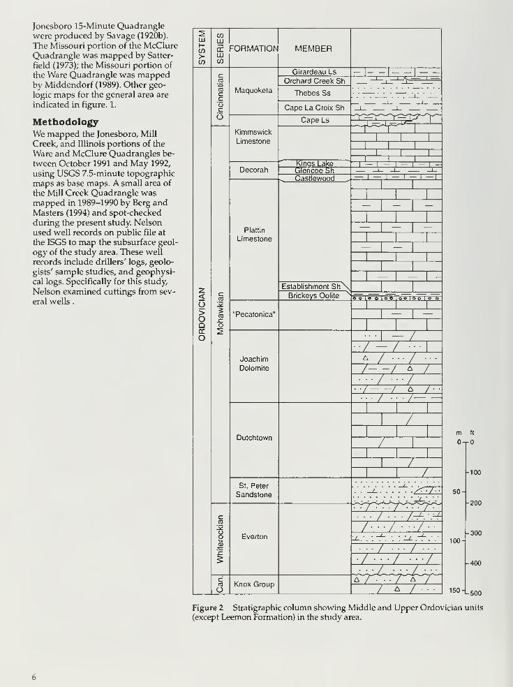
Figure 2 Stratigraphic column showing Middle and Upper Ordovician units
(except Leemon Formation) in the study area.
STRATIGRAPHY
The Jonesboro Quadrangle contains
Cambrian through Mississippian
sedimentary rocks, weakly lithified
Cretaceous and Tertiary sediments,
and unlithified Quaternary sedi-
ments. The oldest rocks exposed in
the study area are Late Ordovician
(fig. 2). Cambrian through MiddleOrdovician rocks are known fromlogs of deep boreholes and from ex-
posures west of the study area in
Missouri.
Mt. Simon (Lamotte)SandstoneThe oldest rock unit known in the
Jonesboro Quadrangle is the Cam-brian-age Mt. Simon (Lamotte) Sand-stone, which was penetrated by the
Humble Oil Company no. 1 Pickel
borehole, in the NW SE NW, Sec. 21,
T13S, R2W, in the Mill Creek Quad-rangle. In this well, 122 feet of Mt. Si-
mon was drilled, and the base of the
formation was not reached. Thesandstone is described on the samplelog as white to pink, fine to mediumgrained quartz arenite with silica
cement. This lithology is typical of
the upper part of the Lamotte Sand-stone on the Ozark Dome in Mis-
souri (Hayes and Knight 1961) andthe upper Mt. Simon Sandstone in
the subsurface throughout Illinois
(Buschbach 1975). The Lamotte andMt. Simon are correlative units of the
St. Croixan Series (Late Cambrian).
Knox GroupThe name Knox Group is applied to
the thick succession of Upper Cam-brian and Canadian (Lower Ordovi-
cian) carbonate rocks overlying the
Mt. Simon Sandstone in the south-
ern part of the Illinois Basin. Equiva-lent formations that outcrop on the
Ozark Dome in Missouri are difficult
to trace into the subsurface becauseof lithologic similarity and down-dip facies changes.
A total of 6,624 feet of Knox strata
was penetrated in the Humble no. 1
Pickel well. Subdivision of the KnoxGroup in the Pickel well (table 1) is
made on the basis of geophysical log
interpretation and sample and insol-
uble-residue analysis by M.L. Sar-
gent (written communication, 1992).
Formation names are the same as
those used for strata outcropping to
the west of the study area, on the
Ozark Dome in Missouri. For com-parison, thicknesses of Cambrianunits in Missouri (from Martin et al.
1961) and of Ordovician units (from
Thompson 1991) are also listed in
table 1. The table shows that the en-
tire Knox Group and every constitu-
ent formation thickens eastwardfrom Missouri to the Pickel well.
This eastward thickening conformswith regional trends mapped by Sar-
gent (1991, p. 82).
Everton FormationThe Everton Formation is a unit of
Whiterockian age. It is composed of
interbedded sandy dolomite anddolomitic sandstone, and it uncon-formably overlies the Knox Group(Kolata and Noger 1991, Thompson1991). In the Humble no. 1 Pickel
well, the Everton Formation com-prises about 240 feet of sandy dolo-
mite that is light to medium brownand micritic to coarsely crystalline.
The Ohio Oil Company no. 1 Crosswell, located in the NW NW NE,Sec. 21, T13S, R2W, in the Jonesboro7.5-Minute Quadrangle, reached
total depth about 15 feet into the
Everton Formation. The Everton is
56 and 106 feet thick, according to
the sample logs of two deep wells 8
to 10 miles southeast of the studyarea in Pulaski County. The Everton
thickens southeastward, from about70 feet in Perry County, Missouri, to
more than 400 feet in the subsurface
in southeastern Illinois (M.L. Sar-
gent, personal communication,1994). Variations in thickness of the
Everton may reflect (1) differential
subsidence during deposition,
(2) deposition of the Everton on anirregular erosional surface, and(3) erosion of the Everton before
deposition of the St. Peter Sandstone.
St. Peter SandstoneThe St. Peter Sandstone is one of the
most widespread and easily recog-
nized formations of the central
United States. It is predominantlywhite to light gray, fine to coarse
grained, well rounded and frosted
quartz sand that is generally weaklycemented. Beds of sandy dolomite
occur locally. The St. Peter is
assigned to the lower MohawkianSeries (Middle Ordovician) and over-
lies the Everton Formation discon-
formably in most places (Kolata andNoger 1991, Thompson 1991).
The St. Peter is 48 feet thick in the
Humble no. 1 Pickel well and 40 feet
thick in the Ohio Company no. 1
Cross well, both of which are on the
Harrison Creek Anticline. At the
nearest outcrops in Missouri, 8 to 10
miles west of the study area, the St.
Peter averages about 100 feet thick
(Thompson 1991, Nelson 1995). Twodeep wells southeast of the studyarea, in Pulaski County, Illinois, pene-
trated 130 to 150 feet of St. Peter.
Thinning of the St. Peter in the
Pickel and Cross wells indicates that
the Harrison Creek Anticline rose
during early Mohawkian sedimenta-
tion. Alternatively, the thinning
might simply reflect deposition of
the St. Peter on an uneven erosional
surface.
Dutchtown FormationThe Dutchtown is about 200 feet
thick in the Cross well and 361 feet
thick in the Pickel well. In bothwells, the Dutchtown is composedof dark-colored, micritic to finely
crystalline limestone, in addition to
dolomite that is argillaceous andpartly sandy. Identification of the
Dutchtown is more definitive in the
Pickel well, for which geophysical
logs are available in addition to a
sample log.
In its type area of southeastern
Missouri, the Dutchtown is com-posed of dark brownish gray,
micritic to very finely crystalline
limestone and dolomite, containing

Table 1 Thicknesses and lithologies of formations in the Knox Group in the Humble no. 1 Pickel well (from
M.L. Sargent, written communication, 1992). Thicknesses of the units at the nearest outcrops in southeast
Missouri are given for comparison.
Unit Thickness Outcrop
(oldest first) (ft) thickness (ft) Lithology
Cambrian SystemBonneterre Fm 600 375-400
Davis Fm 136 170-225
Derby/Doerun Fms 544 0-200
Potosi Dolomite 978 75-300
Eminence Dolomite 758 200-350
Ordovician System, Canadian Series
Gasconade Fm 584 400-500
Roubidoux Fm 640
Jefferson City Fm 606
Cotter Dolomite 871
Powell Dolomite 389
Smithville Dolomite 188
Unnamed unit 330
Total Knox Group 6,624
200-250
250
350-500
100-150
150
?
2,270-3,275
Dolomite, sandy, glauconitic, increasingly sandy near base
Calcareous dolomite to dolomitic limestone, light to mediumbrown, oolitic
Dolomite, slightly sandy, very cherty
Dolomite, sandy, cherty, with quartz-filled vugs (drusy quartz)
Dolomite, slightly sandy, very cherty; some oolitic chert
Dolomite, light brownish gray, cherty; basal Gunter Sandstone
Member about 30 feet thick
Dolomite, cherty, very sandy; sandstone, fine to medium,rounded, dolomitic
Dolomite, slightly sandy, very cherty with oolitic chert
Dolomite, sandy, with thin interbeds of sandstone
Dolomite, slightly sandy, with dolomoldic chert
Dolomite, argillaceous to silty, with vitreous chert
Dolomite, mostly fine grained, argillaceous
finely disseminated organic matter
and bitumen-filled vugs (Martin et
al. 1961, Thompson 1991). TheDutchtown thins northward; it is
about 185 feet thick in southern
Cape Girardeau County and pinches
out in Perry County, Missouri (Nel-
son 1995).
Joachim DolomiteThe Joachim Dolomite is composedof light to medium gray and brown,very fine to fine grained sandy dolo-
mite containing little chert. Lesser
amounts of limestone occur in the
upper part of the formation. Thin
interbeds of gray dolomitic shale are
present throughout the unit, andsandstone interbeds are common in
the lower part (Thompson 1991).
The Joachim in both the Ohio Com-pany no. 1 Cross and Humble no. 1
Pickel wells is about 230 feet thick
and is lithologically similar to
Joachim in outcrops in Missouri. TheJoachim was reported to be 190 to
275 feet thick in the Missouri part of
the Cape Girardeau Quadrangle(Satterfield 1973).
Pecatonica Formation"The Pecatonica Formation wasnamed by Hershey (1894) for its
type locality in northern Illinois. It
was extended into southeastern Mis-
souri by Templeton and Willman
(1963). The Pecatonica was recently
mapped in several quadrangles in
southeastern Missouri. Comparisonof maps and lithologic descriptions
indicate, however, that the Peca-
tonica was not consistently differen-
tiated from the overlying Plattin
Limestone in these quadrangles
(Nelson 1995). Thompson (1991,
p. 109) regarded identification of the
Pecatonica in Missouri to be "tenta-
tive and questionable" and placed
"Pecatonica Formation" in quotation
marks. Thompson stated that the
"Pecatonica" is nearly identical in
lithology to the Plattin.
The "Pecatonica" was tentatively
identified in the Humble no. 1 Pickel
well as a 93-foot-thick interval of
dark, micritic limestone; it overlies
sandy dolomite of the Joachim andunderlies a thin oolitic limestone
thought to be the basal Brickeys
Member of the Plattin Limestone
(M.L. Sargent, written communica-tion, 1992). Other wells in and close
to the study area lack logs that are
sufficiently detailed to differentiate
the "Pecatonica" from the Plattin.
Plattin LimestoneThompson (1991, p. 127) stated that
the Plattin Limestone in southeast-
ern Missouri can be classified as
either a formation or a group, "ac-
cording to the needs of the worker."
Although some geologists divide the
Plattin into formations, quadranglemappers in southeastern Missouri
treated it as a single unit. The Plattin
is difficult to subdivide in the sub-
surface, although the Brickeys andEstablishment Members can be iden-
tified in some wells.
The Plattin is composed largely
of brownish gray mottled and bur-
rowed lime mudstone, similar to
that of the "Pecatonica Formation."
It is argillaceous and contains chert,
but it lacks sand. Thin intervals of
skeletal grainstone occur within the
Plattin. The Brickeys Member, at the
base, contains oolitic grainstone andis overlain by the thin but very wide-
spread Establishment Shale Member.The oolitic limestone is distinctive in
well cuttings, and the shale can beidentified on many geophysical
logs, particularly gamma-ray logs.
Three wells in the study area
penetrated the entire Plattin. In the
Humble no. 1 Pickel well, the
Plattin (to the base of the Brickeys
Member) is 432 feet thick, and the
combined Plattin-'Tecatonica"
thickness is 525 feet (M.L. Sargent,
written communication, 1992).
Undivided Plattin-'Tecatonica" is
about 665 feet thick in the Ohio Oil
Company no. 1 Cross well and 693
feet thick in the Mims no. 1 Potash-
nick well (NW NW SE, Sec. 26, T13S,
8

R3W, McClure Quadrangle). Region-
ally, the Plattin-'Tecatonica" thick-
ens southeastward; it is 500 to 525
feet thick in the Cape Girardeau
Quadrangle (Satterfield 1973), 345 to
420 feet thick in wells north of the
study area in Jackson County, and715 to 780 feet thick in wells to the
southeast in Pulaski County.
The contact of the Plattin with the
overlying Decorah Formation is un-
conformable (Templeton and Will-
man 1963).
Decorah FormationGeologists variously classify the
Decorah as a formation (Decorah
Shale), a subgroup (Templeton andWillman 1963), or a group (Thomp-son 1991). In and near the study
area, the Decorah is only 40 to 60
feet thick and cannot be subdivided
except in unusually good exposures
(such as quarry faces and cores).
Most mappers in southeastern Mis-
souri either combined the Decorahand Plattin into one unit or did not
distinguish the Decorah at all. TheDecorah is treated as a formation in
this report; the name Decorah For-
mation is used instead of DecorahShale because limestone is a majorconstituent.
Cores from the northern ThebesQuadrangle, a few miles south of
the study area, provide the best in-
formation on the Decorah. In these
cores, the Decorah comprises 8 to 17
feet of fossiliferous, shaley limestone
that has thin shale interbeds. Thelimestone is light to medium brown-ish gray lime mudstone and skeletal
wackestone; the shale is light green-
ish gray to brownish gray, slightly
fissile, and calcareous. Bedding is
wavy, contorted, and nodular. Tre-
postome, bifoliate, and fistuliporid
bryozoans; brachiopods, including
Rafinesquina and Hebertella; gastro-
pods; rugose corals; and echinodermfragments are common. The contact
with the Plattin Limestone is grada-
tional in these cores, whereas the
Decorah-Kimmswick contact is
sharp and probably disconformable.
In wells lacking cores, the Deco-rah can be distinguished from the
Plattin below and Kimmswick Lime-stone above by its greater clay con-
tent. The threefold division cited byThompson (1991) can be recognized
in wells for which good sample stud-
ies and geophysical logs are avail-
able. A lower argillaceous limestone
(Castlewood) is overlain by a fossil-
iferous shale (Glencoe) and an upperargillaceous or silty limestone
(Kings Lake). Only the Glencoe
Shale can be identified on most of
the geophysical logs. In and near the
Jonesboro Quadrangle, the Decorahis about 40 to 60 feet thick, and the
Glencoe is 15 to 20 feet thick. TheDecorah Formation is disconform-
ably overlain by the KimmswickLimestone (Thompson 1991).
Kimmswick LimestoneThe Kimmswick Limestone wasnamed for exposures at Kimmswick,Missouri, about 20 miles south of St.
Louis (Ulrich 1904). Although Tem-pleton and Willman (1963) reclassi-
fied the Kimmswick as a subgroupof the Galena Group in Illinois,
geologists in Missouri continue to
rank the Kimmswick as a formation.
Thompson (1991) points out that the
Kimmswick in Missouri is substan-
tially different in lithology from the
type Galena of northwestern Illinois.
The Kimmswick is a high-calcium
limestone (coarse crinoidal grain-
stone), whereas the Galena is a fine
to medium grained, argillaceous,
and cherty dolomite. The Kimms-wick in the Jonesboro area has the
same lithology as occurs at the type
locality and cannot be divided read-
ily into smaller units. Therefore, weuse the name Kimmswick Limestonerather than Kimmswick Subgroup of
the Galena Group.The Kimmswick crops out in the
Missouri part of the McClure andCape Girardeau Quadrangles (Satter-
field 1973) and in the Thebes Quad-rangle in Illinois immediately south
of the study area (J. Weller andEkblaw 1940, Pryor and Ross 1962).
Excellent exposures of the Kimms-wick are at the Grays Point Quarryin the Thebes Quadrangle. Several
wells in the McClure and Mill CreekQuadrangles penetrate the Kimms-wick. Also, cores of the Kimmswickfrom the northern Thebes Quadran-gle were examined. In these out-
crops and wells, the Kimmswick is
white to light gray, mostly coarse
grained crinoidal grainstone, whichcontains practically no terrigenous
clastic material. Thin intervals of
darker, finer grained wackestoneand packstone occasionally occur in
the upper part. Stylolites are com-
mon, as are vugs, some of which are
lined with asphaltic residue. Black,
semivitreous chert nodules are com-mon 20 to 40 feet below the top of
the formation. Fossils include the
distinctive "sunflower coral" Recep-
taculites, in addition to gastropods,
bryozoans, ostracods, illaenid trilo-
bites, and the brachiopods Hebertella
and Platystrophia. Light gray vuggyand crystalline dolomite is reported
in the Kimms-wick in sample logs
from wells north of the Jonesboro 15-
Minute Quadrangle. The Kimms-wick ranges from about 115 to 160
feet thick in wells in and adjacent to
the study area. The Kimmswick is
assigned to the upper part of the
Mohawkian Series (Thompson1991).
Cape LimestoneThe Cape Limestone was named for
Cape Girardeau, Missouri, by Tem-pleton and Willman (1963); the type
section is on Main Street north of
Broadway. This unit was previously
called the Fernvale Limestone(Savage 1920b, J. Weller and Ekblaw1940). The Cape was classified as a
formation in the Maquoketa Groupby Templeton and Willman (1963)
and as a separate formation byThompson (1991). The type section
consists of 8 feet of medium to darkgray, very fossiliferous, crinoidal
limestone that is distinctly darker,
finer grained, and more argilla-
ceous than the upper part of the
Kimmswick (Thompson 1991). TheCape is middle Cincinnatian (Mays-villian to early Richmondian; Sweetetal. 1975) and is separated by dis-
con-formities from the Kimmswickbelow and the Maquoketa above(Templeton and Willman 1963,
Thompson 1991).
We examined the Cape interval in
several cores taken from the north-
ern Thebes Quadrangle. Medium to
dark gray, fine grained limestone as
thick as 22 feet occurs at the top of
the Kimmswick in some cores. This
rock is largely skeletal packstone,
but it contains layers of wackestoneand lime mudstone. The contact
with typical Kimmswick crinoidal
grainstone is either gradational or
sharp, but it is not noticeably discon-
formable. Whether the dark lime-
stone in these cores is the Cape or a
dark facies of the Kimmswick is not
certain.

A dark, fine grained limestone
that may be Cape was logged in
several other boreholes in the area.
In the Humble no. 1 Pickel well, the
Cape (?) is about 18 feet of brown,very fine grained fossiliferous lime-
stone. In the Mims no. 1 Potashnick
well, the Cape (?) is 23 feet of light
brownish gray, very fine grained
shaley limestone. Two wells in Pu-
laski County encountered limestone
that may also be the Cape; it is 5 feet
thick in one well and 12 feet thick in
the other.
The mappability of the CapeLimestone is not resolved. The Capeshould perhaps be classified as a
member of the Kimmswick instead
of as a separate formation (fig. 2).
Maquoketa FormationThe oldest bedrock unit that crops
out in the Jonesboro 15-Minute
Quadrangle is the Maquoketa For-
mation. The Maquoketa Shale wasnamed by White (1870) for outcrops
near Maquoketa, Iowa, where the
unit consists of shale with interbeds
of limestone. Templeton and Will-
man (1963) elevated the Maquoketato a group in Illinois. In southeast-
ern Missouri and southern Illinois,
some geologists classified the
Maquoketa as a group (Middendorf1989, Middendorf et al. 1988,
Thompson 1991), whereas others
called it a formation (Pryor and Ross
1962, Satterfield 1973, Johnson 1985).
Among those who mapped the
Maquoketa, most portrayed it either
as a single unit or combined two or
more members (formations) as a
matter of convenience.
Subdivisions of the Maquoketaare thin (averaging 35 to 50 ft) in the
study area, and their contacts inter-
grade vertically and laterally.
Although distinct lithologically,
these subdivisions cannot bemapped reliably and portrayed at
scales of 1:24,000 and smaller. More-over, these subdivisions can be rec-
ognized in only a small area of
southeastern Missouri and south-
western- most Illinois. The subdivi-
sions thus fail the test of mappa-bility for valid formations (North
American Stratigraphic Code 1983)
and are properly classified as mem-bers. Accordingly, we classify the
Maquoketa as a formation divided
into four members: Cape La Croix
Shale (oldest), Thebes Sandstone,
Orchard Creek Shale, and Girardeau
Limestone. The name MaquoketaFormation is used instead of
Maquoketa Shale because sandstoneand limestone are important con-
stituents.
In wells in the study area, the
Maquoketa ranges from 140 to 200feet thick. Similar thicknesses are re-
ported by Pryor and Ross (1962) for
the Thebes Quadrangle and by Sat-
terfield (1973) for the Missouri por-
tion of the McClure and Cape Girar-
deau Quadrangles. The Maquoketathickens to 170 to 210 feet in wells
southeast of the Jonesboro Quadran-gle. A regional isopach map of the
Maquoketa shows that the unit
thickens eastward across the Illinois
Basin and that a locally thick area
(more than 300 ft) occurs in western
Kentucky (Whitaker 1988).
The Maquoketa was assigned to
the Richmondian Stage of the Cincin-
natian Series by Sweet et al. (1975)
on the basis of conodont faunas.
Cape La Croix Shale Member TheCape La Croix Shale was named (as
a formation) by Thompson (1991)
for Cape La Croix Creek in the north-
ern part of the Cape Girardeau Quad-rangle. The type section consists of
17 feet of bluish gray, calcareous,
platy shale containing occasional
nodules and thin beds of limestone.
This unit was described previously
as an unnamed member or forma-
tion of the Maquoketa.The Cape La Croix does not crop
out in the Jonesboro Quadrangle,
but well records indicate that it is
present. Drill cores from the Thebes
Quadrangle show the Cape La Croix
to be 24 to 36 feet thick and com-posed of dark gray to olive gray clay
shale or silty shale that commonlygrades to siltstone near the top. Theshale is slightly fissile, calcareous,
and contains gastropods, nautiloid
cephalopods, ostracods, trilobites,
and brachiopods. Thin interbeds
and lenses of fossiliferous lime mud-stone occur in the shale. The basal
portion of the Cape La Croix is a
soft, gummy claystone that yields
poor core recovery. The Cape LaCroix grades upward to the ThebesSandstone Member.
Well records in the Jonesboro
Quadrangle indicate the Cape La
Croix to be dark shale 35 to 60 feet
thick. Southeast of the study area,
well records show the member is 90
to 150 feet thick, apparently thicken-
ing at the expense of the Thebes.
Thebes Sandstone Member TheThebes Sandstone was named byWorthen (1866) for Thebes, Illinois.
The Thebes is restricted to a small
area of southeastern Missouri andsouthwestern Illinois.
The Thebes crops out at the crest
of the Harrison Creek Anticline in
the SW NE SW, Sec. 16, T13S, R2W,in the Jonesboro 7.5-Minute Quad-rangle, and in the bluff at Gale, NESW, Sec. 33, T14S, R3W, in the
McClure Quadrangle. It is com-posed of siltstone and very fine
sandstone in this area. These rocks
are light to medium gray, greenish
gray, and brownish gray, and lami-
nated to thinly bedded. They are
composed largely of subangularquartz sand having a clay matrix
and calcite cement. Interlaminations
of silty shale are present. The onlyfossils noted are horizontal burrowsand trails. Well records indicate the
Thebes is 25 to 60 feet thick in the
Jonesboro Quadrangle.Outcrops and cores from the
northern Thebes Quadrangle showthe Thebes to be as thick as 110 feet
and composed of siltstone to very
fine grained, argillaceous sandstone.
Bedding or lamination is weakly de-
veloped and commonly obscured bybioturbation. Numerous burrowedintervals are present, particularly in
the lower part of the member. Adistinctive unit at the base of the
Thebes is composed of dark gray
mudstone containing small inarticu-
late brachiopods and other fossils,
along with small, dark gray to black
spherical pellets (phosphate?). Mud-stone variegated in red, green, andochre occurs at the top of the Thebesin some cores.
The Thebes thins eastward andnorthward in the subsurface, grad-
ing laterally to siltstone and silty
shale and intertonguing with the
Cape La Croix Shale. It is restricted
to southern Jackson and part of
Pulaski Counties as well as all of
Union and Alexander Counties. TheCape La Croix and Orchard Creek
Shales cannot be differentiated in
areas where the Thebes is absent.
The upper contact of the Thebes is
sharp but apparently conformable.
Orchard Creek Shale MemberThe Orchard Creek Shale wasnamed by Savage (1909) for a creek
about 2 miles (3 km) south of
Thebes, Illinois, which is south of
the report area. The Orchard Creek
10

crops out in a small area near Gale
in the McClure Quadrangle andsouth of Harrison Creek at the crest
of the Harrison Creek Anticline. It is
not well exposed. The upper part of
the Orchard Creek and the grada-
tional contact with the overlying
Girardeau Limestone can be seen
along Harrison Creek in the SW SWNE, Sec. 16, T13S, R2W. More details
of the Orchard Creek are knownfrom well records, particularly from
cores from the Thebes Quadrangle.
Lithologically, the Orchard Creek
is similar to the Cape La Croix Mem-ber. The shale is greenish gray to
olive gray (less commonly dark gray
to black), soft and fissile, and partly
silty, becoming siltier upward. Theupper part is strongly calcareous,
the lower part less so. Nodules andthin interbeds of dense, argillaceous
lime mudstone increase in numberand thickness upward, as the
Orchard Creek grades into the over-
lying Girardeau Limestone Member.Satterfield (1971) found that the
Girardeau thickens westward at the
expense of the Orchard Creek andsuggested that the two members are
facies equivalents.
Fossils from the Orchard Creekinclude rare Flexicalymene sp., Cerau-
rus sp., and disarticulated large vag-
desid trilobites. More common are
crinoid columnals and ramose bryo-
zoans.
The Orchard Creek is about 25
feet thick in outcrops in the studyarea, as well as in cores from the The-
bes Quadrangle. The unit is reported
to be 60 to 70 feet thick in the Mis-
souri part of the Ware Quadrangle(Middendorf 1989), 30 to 60 feet
thick in the Cape Girardeau Quad-rangle (Satterfield 1973), 22 to 30 feet
thick in the Thebes Quadrangle(Pryor and Ross 1962), 50 to 80 feet
thick in wells east of the outcrop in
the Thebes Quadrangle, and as
much as 100 feet thick in wells far-
ther east in Pulaski County.
Girardeau Limestone MemberThe Girardeau Limestone wasnamed by Shumard (1855) for CapeGirardeau; the type locality is at
Cape Rock, northeast of the city
along the Mississippi shore. Thetype section was described in detail
by Satterfield (1971, p. 266) andThompson (1991). The Girardeauhas heretofore been ranked as a for-
mation and placed in the MaquoketaGroup by Thompson (1991).
Early workers in the region, in-
cluding Savage (1920b), J. Weller
and Ekblaw (1940), and Pryor andRoss (1962), assigned the Girardeau
to the Silurian System. Study of the
conodont fauna by Satterfield (1971)
indicated that the Girardeau is Rich-
mondian (late Ordovician). Brower(1973) suggested, on the basis of a
study of the crinoid fauna, that the
Girardeau was Richmondian or
slightly younger (Gamachian Stage).
He also suggested that it may be ear-
liest Silurian age.
The Girardeau Member is ex-
posed along the Harrison CreekAnticline in the southwestern part of
the Jonesboro 7.5-Minute Quadran-gle, in a small area north of Valley
Mission in the Mill Creek Quadran-gle, and in the bluffs northeast of
Gale in the McClure Quadrangle.
The best exposure is a bluff south of
Harrison Creek near the center of
Sec. 16, T13S, R2W.In the study area, as at the type
locality, the Girardeau is composedof medium to dark gray and olive
gray lime mudstone in thin wavyand lenticular beds. Dark gray chert
nodules are common in the upperpart. Interbeds of greenish gray cal-
careous shale occur throughout the
unit and become thicker and morenumerous toward the base. Fossils
are scarce; they include well pre-
served crinoids, carpoids, edrioas-
teroids, tentaculids, and trilobites.
The member is 20 to 30 feet thick in
both outcrop and the subsurface.
Identification of the Girardeau in
well records is a bit tenuous because
the unit is thin and similar to the
overlying Sexton Creek Limestone.
The Girardeau is disconformably
overlain by either the Leemon For-
mation or the Sexton Creek Lime-stone. The Sexton Creek overlies the
Girardeau along the top of the bluff
south of Harrison Creek; the contact
is sharp and planar to slightly irregu-
lar. Where the Girardeau Member is
eroded, the Sexton Creek directly
overlies the Orchard Creek Member(Thompson 1991).
Leemon FormationA unit previously called the Edge-wood Formation was renamed the
Leemon Formation by Thompsonand Satterfield (1975). The type local-
ity of the Leemon is in the CapeGirardeau Northeast Quadrangle. It
is classified as a formation, despite
being discontinuous and less than 25
feet thick. Pending further study,
that rank is left unchanged.The Leemon does not crop out in
the Jonesboro 15-Minute Quadran-gle, but it does occur in the ThebesQuadrangle (Savage 1920b, Pryor
and Ross 1962) and in nearby areas
of Missouri. In those places, the
Leemon is an oolitic and skeletal
grainstone, commonly crossbeddedand containing thin interbeds of
shale. Phosphatic pebbles and clasts
eroded from the underlying Girar-
deau Limestone are common near
the base (Thompson and Satterfield
1975, Thompson 1991).
The Leemon probably is present
in several wells in and near the re-
port area. It is logged as oolitic lime-
stone and is less than 20 feet thick.
An isopach map by Rogers (1972)
shows the "Edgewood" (Leemon)largely absent east of the outcrop
belt in far southern Illinois, but it
thickens northeast of the study area
to more than 66 feet.
The Leemon ("Edgewood") origi-
nally was assigned to the Silurian
System, but a study of the conodontfauna by Thompson and Satterfield
(1975) established late Richmondian(latest Ordovician) age. Later,
Amsden and Barrick (1986) placed
the Leemon of southwestern Illinois
within the Hirnantian Stage. Thecontact of the Leemon to the Sexton
Creek Limestone is disconformable.
Where the Leemon is missing, the
Sexton Creek Limestone rests on the
Maquoketa Formation (Pryor andRoss 1962, Thompson 1991).
Sexton Creek LimestoneThe type section of the Sexton CreekLimestone is in the Mississippi River
bluff in the SW, Sec. 27, T14S, R3W,McClure Quadrangle (Savage 1909).
This unit crops out northward along
the bluffs and also near the mouth of
Dongola Hollow in the McClureQuadrangle. It is also exposed along
the crest of the Harrison Creek Anti-
cline in the northwestern Mill Creekand southwestern Jonesboro 7.5-
Minute Quadrangles. A fine expo-
sure is just north of the mouth of
Dongola Hollow in the SE NW,Sec. 12, T14S, R3W, McClure Quad-rangle (fig. 3). The lower part (in-
cluding the basal contact) crops out
on the south side of Harrison Creekin the center of Sec. 16, T13S, R2W,Jonesboro Quadrangle.
11

.«*r
W-* ~ -Figure 3 Sexton Creek Limestone and St. Clair Limestone Member of Bain-
bridge Formation, north of the mouth of Dongola Hollow, NW SE NW, Sec. 12,
T14S, R3W, McClure Quadrangle. The Sexton Creek is the lower unit that con-
tains numerous thin dark chert layers; the St. Clair is the overlying thick beddedlimestone. The height of the exposure is about 40 feet.
The lithology is distinctive:
medium brownish gray, slightly
argillaceous lime mudstone andskeletal wackestone, containing
regular layers of caramel-colored to
greenish gray chert (figs. 3, 4). Caly-
menid trilobite fragments and large
biscuit-shaped colonies of Favosites
sp. are common in the upper part.
The Sexton Creek somewhat resem-
bles the Girardeau Limestone, but
the Sexton Creek contains less shale
and more chert (20-30% of the unit),
and it has more regular layers. TheSexton Creek is described in samplelogs as white to light and mediumbrownish gray micritic limestone,
which is argillaceous and contains
shale laminae and abundant chert.
The contact of the Sexton Creekwith the overlying Bainbridge For-
mation is sharp, but it appears to beconformable. The Sexton Creek is
about 40 feet thick in outcrops in the
study area. It is 30 feet thick in the
Schneider Drilling Company Pearce
water well (Sec. 6, T14S, R2W). Re-
ported thicknesses are 30 to 35 feet
in the Missouri part of the McClureand Cape Girardeau Quadrangles(Satterfield 1973), 30 to 40 feet in the
Missouri part of the Ware Quadran-gle (Middendorf 1989), and 15 to 40
feet thick in the Thebes Quadrangle(Pryor and Ross 1962). The Sexton
Creek is 45 to 92 feet thick in wells
located southeast of the Jonesboro
Quadrangle. North of the report
area, in Jackson and southern UnionCounties, the unit is 30 to 95 feet
thick. An isopach map of the Alex-
andrian Series (Sexton Creek plus
Leemon) (Willman and Atherton
1975) shows that the limestone thick-
ens to the north and east of the
study area to a maximum of morethan 125 feet in Franklin County,
Illinois.
Most workers since Savage (1920b)
consider the Sexton Creek to be of
Alexandrian age, equivalent to the
Brassfield Formation in Kentucky.
Thompson (1987) suggested that the
Sexton Creek ranges from the Alex-
andrian into the lower part of the
Clintonian Stage, Niagaran Series.
Bainbridge FormationThe Bainbridge Formation wasnamed by Ulrich (1904, p. 110), andits type section was described in de-
tail by Ball (1939). The type section
is in the Mississippi River bluff in
the SE SE NW, Sec. 24, T32N, R14E,Ware Quadrangle (Missouri). It con-
sists of 120 feet of interbedded varie-
gated red and green silty limestone
and calcareous shale, grading up-ward into the Bailey Formation.
Basal beds of the Bainbridge are cov-
ered at the type section.
The Bainbridge is ranked as a for-
mation by some stratigraphers andas a group by others. The lower sub-
division, the St. Clair Limestone, is
too thin and poorly exposed to bemapped as a formation in the study
area. Accordingly, we treat the Bain-
bridge as a formation, containing
the Seventy-Six, St. Clair, and Mocca-sin Springs Members (fig. 5).
Seventy-Six Shale MemberSatterfield and Thompson (1975)
named the Seventy-Six Shale Mem-ber of the Bainbridge Formation for
a village in the Altenburg Quadran-gle, Perry County, Missouri. Theydescribed the member as vari-
egated brick-red and green, partly
fissile, calcareous, glauconitic shale
that contains hematitic "buttons"
and ranges from a few inches to 4
feet thick. We did not observe the
Seventy-Six Shale during this study,
but Satterfield and Thompson(1975) reported that they dug it outof the bluff north of Dongola Hol-
low in the "NW 1/* NEM NWW', Sec.
12, T14S, R3W, McClure Quadran-gle. The cited location is on the Mis-
sissippi floodplain and probably is
a misprint. The correct location
probably is NW NW NE, Sec. 12.
St. Clair Limestone MemberThe St. Clair Limestone was defined
in Independence County, Arkansas,
by Penrose (1891) and extended into
southern Illinois by Lowenstam(1949). It has been classified as a for-
mation but in this report it is consid-
ered a member of the Bainbridge
Formation. The "McClure Lime-stone" shown on the stratigraphic
12
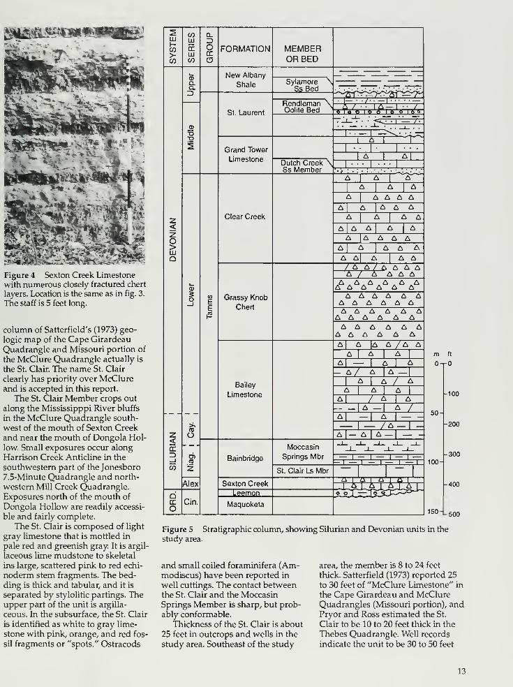
S^«t^«3»MPMPMSy
Figure 4 Sexton Creek Limestone
with numerous closely fractured chert
layers. Location is the same as in fig. 3.
The staff is 5 feet long.
column of Satterfield's (1973) geo-
logic map of the Cape Girardeau
Quadrangle and Missouri portion of
the McClure Quadrangle actually is
the St. Clair. The name St. Clair
clearly has priority over McClureand is accepted in this report.
The St. Clair Member crops out
along the Mississipppi River bluffs
in the McClure Quadrangle south-
west of the mouth of Sexton Creekand near the mouth of Dongola Hol-
low. Small exposures occur along
Harrison Creek Anticline in the
southwestern part of the Jonesboro
7.5-Minute Quadrangle and north-
western Mill Creek Quadrangle.
Exposures north of the mouth of
Dongola Hollow are readily accessi-
ble and fairly complete.
The St. Clair is composed of light
gray limestone that is mottled in
pale red and greenish gray. It is argil-
laceous lime mudstone to skeletal
ins large, scattered pink to red echi-
noderm stem fragments. The bed-
ding is thick and tabular, and it is
separated by stylolitic partings. Theupper part of the unit is argilla-
ceous. In the subsurface, the St. Clair
is identified as white to gray lime-
stone with pink, orange, and red fos-
sil fragments or "spots." Ostracods
LUI-co
CO
o>LUQ
<CCZ)_J
to
Qcc
o
COUJ
ccLUCO
03
o
ca
Alex
Cin.
o.
occ
CD
FORMATION
Grand Tower
Limestone
Clear Creek
Grassy Knob
Chert
Bailey
Limestone
Bainbridge
Sexton Creek
Leemon
Maquoketa
MEMBERORBED
Dutch Creek \Ss Member
Moccasin
Springs Mbr
St. Clair Ls Mbr
* 1 A |
A A A A AA |
A A A
AAAA A
A A A A A
AT AAAA A A A/ A & / A A A AA / A A A AAAAAAA
A A A A A AA A A A A AAAAAAAAAAAAAAAAAAAAAAAAA
A A A A A AA
|A |A A /A A
A I A I AlA| — | A 1
A- A/ A lA^TT
AH A / AA
IA 1 A|/ a
Ia
--lA-l C~TAl-jA— 1 — /A^A - A A—
-I — .1 - I r- I —J
m ft
0-rO
50-
-200
100-
100
300
400
1 50-L 500
Figure 5 Stratigraphic column, showing Silurian and Devonian units in the
study area.
and small coiled foraminifera (Am-modiscus) have been reported in
well cuttings. The contact betweenthe St. Clair and the MoccasinSprings Member is sharp, but prob-
ably conformable.
Thickness of the St. Clair is about
25 feet in outcrops and wells in the
study area. Southeast of the study
area, the member is 8 to 24 feet
thick. Satterfield (1973) reported 25
to 30 feet of "McClure Limestone" in
the Cape Girardeau and McClureQuadrangles (Missouri portion), andPryor and Ross estimated the St.
Clair to be 10 to 20 feet thick in the
Thebes Quadrangle. Well records
indicate the unit to be 30 to 50 feet
13

thick north of the study area. These
findings are consistent with Lowen-stam's (1949) statement that the St.
Clair thickens progressively north-
east and east from the outcrop area
in southernmost Illinois.
The St. Clair was assigned to the
Clintonian Stage of the NiagaranSeries by Thompson (1987).
Moccasin Springs Member Thethick upper member of the Bain-
bridge Formation is the MoccasinSprings Member, named (as a forma-
tion) by Lowenstam (1949). The type
section of the Moccasin Springs is
the same as that of the Bainbridge.
The Moccasin Springs is a slope-
forming unit exposed only in ravines
and, in some places, on steep bluffs.
It underlies broad valleys along the
crest of the Harrison Creek Anticline
and crops out in the Mississippi
River bluffs near Dongola Hollowand south of Sexton Creek in the
McClure Quadrangle. Most expo-
sures are fragmentary. The mostcomplete sections are in gullies onthe west flank of the Harrison Creek
Anticline in the EVi SE SW, Sec. 9,
and west of the center of the SW,Sec. 16, T13S, R2W, Jonesboro 7.5-
Minute Quadrangle.
The Moccasin Springs is com-posed of interbedded chert-free,
very silty, and argillaceous lime-
stone (lime mudstone) and calcare-
ous mudstone, shale, and siltstone.
Both rock types are mottled and vari-
egated in brick-red, brownish red,
purple, greenish gray, and olive
gray. Limestone is the predominantlithology, but shale interbeds in-
crease in number and thickness up-
ward. The only common fossils are
large nautiloid cephalopods in lime-
stone near the base of the member.In the study area, the MoccasinSprings and St. Clair are the only
Paleozoic units containing muchred. These units are readily recog-
nized in outcrops and well samples
by their distinctive color, and they
are thus noted on most drillers' logs.
An interval of shale about 30 feet
thick commonly occurs at the top of
the Moccasin Springs Member. This
shale was called the Randol shale in
a thesis by Rogers (1972), but this
term has remained informal.
The contact of the MoccasinSprings Member with the overlying
Bailey Limestone is gradational in
the study area, as is the case at the
type section (Ball 1939) and at out-
crops in the Thebes Quadrangle(Pryor and Ross 1962). A gradualcolor change from predominantlybrick-red in the Moccasin Springs to
predominantly greenish gray in the
Bailey marks the transition zone.
The lower part of the Bailey consists
of gray to green cherty limestone.
The limestone has numerous green-
ish gray shale interbeds that de-
crease in number and thickness
upward. The base of the Bailey wasmapped at the lowest occurrence of
gray, cherty limestone.
The Moccasin Springs is about 90feet thick along the Harrison CreekAnticline and about 145 feet thick in
the Pearce water well in Sec. 6, T14S,
R2W, Mill Creek Quadrangle. It is re-
ported to be 100 to 120 feet thick in
the Cape Girardeau and McClureQuadrangles (Satterfield 1973) and100 to 130 feet thick in the ThebesQuadrangle (Pryor and Ross 1962).
Well records show that the MoccasinSprings thickens east of the studyarea to as much as 270 feet in
Pulaski County, Illinois. North of the
study area, in northern Union andJackson Counties, the member is 180
to 215 feet thick. A regional isopach
map by Whitaker (1988) shows the
entire Silurian succession thickening
both northward from the study area,
through Jackson County, and east-
ward through Alexander, Pulaski,
and western Massac Counties.
The Moccasin Springs is gener-
ally considered to be of Niagaranage, but the upper beds may be
Cayugan. Lowenstam (1949, p. 18)
reported that "the uppermost bed(of the Moccasin Springs type sec-
tion) includes a Lissatrypa and other
fossils that suggest a late Silurian
rather than Niagaran age." Grap-
tolites from the upper MoccasinSprings in southern Illinois indicate
correlation with the lower Lud-lovian Stage of Europe (Ross 1962).
Conodonts from the Bainbridge of
northern Perry County, Missouri, in-
dicate late middle to early late Lud-lovian age (Rexroad and Craig
1971). On the COSUNA chart for Illi-
nois (Shaver 1985), the Niagaran-Cayugan Series boundary is shownto be questionably correlative with
the middle Ludlovian. According to
Shaver, the Moccasin Springs is
largely Niagaran, and the overly-
ing Bailey is Cayugan to LowerDevonian.
Bailey LimestoneThe Bailey Limestone was named byUlrich (1904) for the no-longer-extant
community of Bailey's Landing onthe Mississippi River in northernPerry County, Missouri. The Bailey
is a unit of drab-colored, thin bed-
ded, and cherty micritic limestone
containing shale interbeds in the
lower part 0- Weller and Ekblaw1940, Croneis 1944).
The Bailey crops out extensively
in the Jonesboro 7.5-Minute Quad-rangle on both flanks of the Harri-
son Creek Anticline and along the
Mississippi River bluff south of At-
wood Ridge (Nelson and Devera1994). It extends southward through
the western part of the Mill CreekQuadrangle and underlies large
areas of the McClure Quadrangle(Devera et al. 1994). Unfortunately,
the few wells that penetrate the
Bailey lack accurate and detailed logs.
The Bailey is composed of light
brown to yellowish gray, argilla-
ceous to finely silty, dolomitic lime
mudstone. Throughout the Bailey,
the bedding is thin and wavy, andabundant chert occurs as nodules,
lenses, and discontinuous layers.
Most of the chert in the upper part
of the Bailey is off-white to yellow or
orange, and it is somewhat porous.
Nodular chert having a distinctive
convoluted texture is common near
the top. In the lower part of the
Bailey, both limestone and chert are
greenish and contain thin interbeds
of greenish gray shale, which is tran-
sitional from the underlying Bain-
bridge Formation. Chert of the
lower Bailey generally is dense andoccurs in thin, wavy beds rather
than in nodules.
The fauna of the Bailey is sparse.
Sponge spicules, chitinozoans andconodonts, and sparse trilobite andechinoderm fragments are present.
Most macrofossils are in the upperthird of the formation. They include
crinoid fragments and the trilobites
Huntonia palacea, Phacops sp., andDalmanites sp. The trace fossil Zoo-
phycos is common in the upper part
of the Bailey.
The contact with the overlying
Grassy Knob Formation is grada-
tional. An interval of chert nodules
in a matrix of residual silt and clay
marks the contact in the Jonesboro
7.5-Minute Quadrangle.
The Bailey is about 350 feet thick
along the west flank of the Harrison
14
Creek Anticline, where exposures
are best. South of the mouth of Harri-
son Creek, a 300-foot bluff is Bailey
from top to bottom. The Bailey maybe considerably thinner north of
Harrison Creek on the west flank of
the anticline in Sec. 9, T13S, R2W.The Devonian-Silurian systemic
boundary probably lies in the lower
part of the Bailey. Uppermost Bain-
bridge strata contain Late Silurian
fossils, whereas conodont studies
(Collinson et al. 1967) indicate the
upper Bailey is Lower Devonian. To
date, the lower and middle Bailey
have not yielded fossils useful for
biostratigraphic zonation.
Grassy Knob ChertThe Grassy Knob Chert was namedby Savage (1925) for a locality about
10 miles north of the study area in
Jackson County, Illinois. At the type
section, the Grassy Knob overlies
the Bailey Formation and is overlain
by the Backbone Limestone. TheBackbone pinches out south of the
Grassy Knob type section and doesnot occur in the Jonesboro Quadran-gle (Devera 1994).
The Grassy Knob crops out onboth limbs of the Harrison CreekAnticline and in large areas of the
western Mill Creek and eastern
McClure Quadrangles. The upperpart of the Grassy Knob is exposedin the southeastern part of the Mill
Creek Quadrangle. This unit erodes
to a very rugged topography andcaps high hills such as AtwoodRidge in the Jonesboro Quadrangleand Pine Knob in the Mill CreekQuadrangle. Massive chert beds of
the Grassy Knob form discontinuous
cliffs and ledges in many places.
Bedded chert and microcrys-
talline silica make up the GrassyKnob in outcrop. The chert is typi-
cally off-white to light gray, stained
yellow or orange. Most chert is
dense and novaculitic, medium to
thick bedded, and very sparingly
fossiliferous. Chert at the top of the
Grassy Knob is persistently brecci-
ated, and it overlies an interval of
highly porous, "popcorn"-textured
chert riddled with horizontal bur-
rows. Lenses of brecciated chert
occur lower in the formation. In the
northern part of the area, nearly mas-sive, ledge-forming chert occurs
close to the middle of the GrassyKnob. The lower part of the GrassyKnob is predominantly dense, thick
bedded chert. In some places, this
chert has been altered to white or
very light gray, relatively soft and fri-
able microcrystalline silica or tripoli,
which resembles that of the youngerClear Creek Formation.
In the subsurface, the GrassyKnob is predominantly chert similar
to that observed on the outcrop.
Light gray, micritic to fine grained
cherty limestone and dolomite occur
near the top in a few wells.
The Clear Creek Formation over-
lies the Grassy Knob with a conform-able, probably gradational contact
throughout the study area. Litholo-
gies of the Grassy Knob and Clear
Creek are similar, and differentiating
the two can be difficult. Abundanceof fossils is perhaps the best criterion
for differentiation. Only a few poorly
preserved spiriferid (?) brachiopods
have been found in the Grassy Knob,whereas the Clear Creek contains
common, well preserved brachio-
pods and trilobites. Both Grassy
Knob and Clear Creek are burrowed,but burrows typically are horizontal
in the Grassy Knob and vertical in
the Clear Creek. The Grassy Knobcontains fewer clay partings andmore stylolites than does the Clear
Creek. Dense, thick bedded, brecci-
ated and "popcorn" chert are moretypical of Grassy Knob than Clear
Creek, as are yellow to off-white col-
ors. The Grassy Knob contains less
microcrystalline silica than does the
Clear Creek.
The Grassy Knob and Clear
Creek were not differentiated in twoparts of the quadrangle. The larger
area is in the central and south-cen-
tral part of the Mill Creek Quadran-gle; the smaller area is in the WareQuadrangle. The rocks are highly
silicified in both areas, blurring li-
thologic differences; lack of outcrops
and structural complexity further
hamper interpretation.
The Grassy Knob is about 200 to
250 feet thick in the Jonesboro 15-
Minute Quadrangle. No thickness
trends are evident.
Clear Creek FormationThe Clear Creek Chert was namedby Worthen (1866) for Clear Creek in
the Cobden Quadrangle, north of
the Jonesboro Quadrangle. Worthendid not specify a type section, andhis description of the limits of the
Clear Creek is vague. Savage (1920a)
restricted the Clear Creek to strata
between the Backbone Limestone (or
Grassy Knob Chert where the Back-
bone is absent) and the Grand TowerLimestone. Savage's definition is
used here. The unit is called Clear
Creek Formation rather than Clear
Creek Chert because the unit is com-posed of limestone in some areas.
The Clear Creek Formation has
the largest outcrop area of any bed-rock formation in the study area. It
crops out through most of the west-
ern and southeastern parts of the
Mill Creek Quadrangle, much of the
western Jonesboro 7.5-Minute Quad-rangle, and portions of the Ware andMcClure Quadrangles. Many wells
have been drilled into the Clear
Creek but, unfortunately, most lack
detailed logs and none completely
penetrate the formation.
The Clear Creek erodes to a very
steep and rugged topography that is
characterized by deep V-shapedravines and sharp-crested ridges.
The drainage pattern is largely den-
dritic, but a trellis pattern, indicative
of structural control, is developed in
parts of the Mill Creek Quadrangle.Despite the steep topography, out-
crops of the Clear Creek are small
and fragmentary. Most information
on the Clear Creek comes from man-made exposures in silica mines andquarries.
The Clear Creek Formation is 300
to 400 feet thick in the Jonesboro 7.5-
Minute Quadrangle and 200 to 300
feet thick in the Mill Creek andMcClure Quadrangles. Uncertainties
arise from poor exposure, compli-
cated structure, and the locally prob-
lematic lower contact. The Clear
Creek and Grassy Knob cannot be
differentiated in any well logs in the
study area. In a well in Sec. 9, T15S,
R1E, Pulaski County, the Clear
Creek apparently is 550 feet thick
and overlies Backbone Limestone.
Northeast of the study area, in a
well in Sec. 35, T11S, R1W, the Clear
Creek overlies Backbone and is 419
feet thick. Thus, available data indi-
cate that the Clear Creek thickens
from the Ozark Dome to the Illinois
Basin.
Two distinct lithologies of the
Clear Creek are present in the studyarea. The "normal" or unaltered
lithology, found mainly in the north-
ern Jonesboro 7.5-Minute Quadran-gle, is limestone that contains chert
lenses and layers. The "altered"
lithology, found in most of the Mill
15

'Mr
•<,
'*%(¥'
..*--
*-? Si-vim**. * * •*
Figure 6 Manmade exposure of the Clear Creek Formation near the NW corner, Sec. 11, T14S, R2W, Mill Creek Quad-rangle. The photo shows thin alternating layers of tripoli (white) and hard bedded chert (dark). Note the gently undulating
layers and minor faults.
Creek and southern Jonesboro Quad-rangles, is bedded chert and micro-
crystalline silica (tripoli).
Unaltered lithology The unal-
tered lithology of the Clear CreekFormation is limestone containing
subordinate bands and nodules of
chert. Typical exposures occur along
tributaries of Cany Creek in the
western part of Sec. 10 and the north-
ernmost part of Sec. 15, T12S, R2W.In these areas and elsewhere, the
limestone is uniformly light grayand light brownish gray, faintly mot-tled, very siliceous lime mudstone.The texture is generally aphanitic,
but some limestone appears very
finely granular. Scattered bioclasts
are present; they are largely echino-
derm and trilobite fragments, as
well as whole shells of strophe-
menid and spiriferid brachiopods.
Brachiopods are common in the up-
per part of the Clear Creek and un-
common in the middle and lower
parts. Bedding is thin and wavy to
nodular; most beds are 1 to 4 inches
thick, but occasional layers reach
1 foot in thickness. Some limestone
near the top of the Clear Creek is
silty to finely sandy, as reported byAllen (1985) and also as can be
found in sample logs from somewells in the study area.
Chert in unaltered Clear Creek is
dull white to light gray, slightly mot-
tled, and resembles unglazed porce-
lain. In the upper Clear Creek, chert
occurs in distinct lenticular beds andlayers of nodules, 1 to 4 inches thick.
Downward, chert generally blends
into the enclosing limestone. Chert
of the middle and lower Clear Creekis mostly tripolitic and calcareous,
grading to highly siliceous lime-
stone. Contacts between tripolitic
chert and limestone are intricately
intergrown; in places, the rock is
chert with "nodules" of limestone.
This type of rock exfoliates onweathered surfaces of stream banks.
Digging into unweathered rock
yields siliceous limestone and lesser
amounts of chert, similar to that
found near the top of the Clear Creek.
The Clear Creek is fossiliferous,
particularly in the upper part. Formsidentified include Dalmanites prat-
teni, Phacops cristata, Odontochile sp.,
Leonaspis sp., Cordania sp., Eodevon-
aria arcuata, Strophostylus cancellatus,
and Amphigenia curta. Strophemenidand spiriferid brachiopods and echi-
noderm fragments are particularly
common. Trace fossils include verti-
cal burrows, borings in brachiopod
shells, and large domichnia cavities.
Altered lithology Where it is
altered, the Clear Creek Formation is
composed of chert and microcrys-
talline silica. Limestone was leached
out and/or replaced by silica.
Altered Clear Creek is found in
much of the study area (see the red
dashed lines on the geologic mapsof Nelson and Devera 1994, andDevera et al. 1994). Well records
show that the Clear Creek is altered
to at least 400 feet below the surface
in some places.
Bedded chert of the altered Clear
Creek is mottled white to light gray,
16
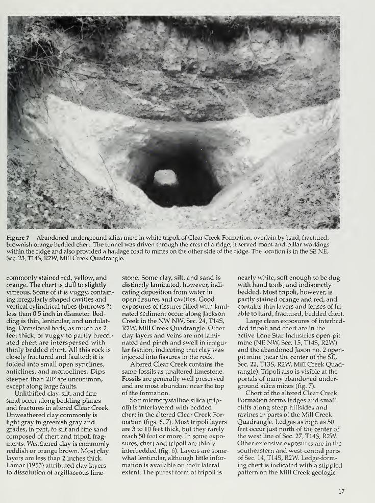
, f
i 4,
*•r:
%>.*> ^Sfc
Figure 7 Abandoned underground silica mine in white tripoli of Clear Creek Formation, overlain by hard, fractured,
brownish orange bedded chert. The tunnel was driven through the crest of a ridge; it served room-and-pillar workingswithin the ridge and also provided a haulage road to mines on the other side of the ridge. The location is in the SE NE,Sec. 23, T14S, R2W, Mill Creek Quadrangle.
commonly stained red, yellow, andorange. The chert is dull to slightly
vitreous. Some of it is vuggy, contain-
ing irregularly shaped cavities andvertical cylindrical tubes (burrows ?)
less than 0.5 inch in diameter. Bed-
ding is thin, lenticular, and undulat-
ing. Occasional beds, as much as 2
feet thick, of vuggy to partly brecci-
ated chert are interspersed withthinly bedded chert. All this rock is
closely fractured and faulted; it is
folded into small open synclines,
anticlines, and monoclines. Dips
steeper than 20° are uncommon,except along large faults.
Unlithified clay, silt, and fine
sand occur along bedding planes
and fractures in altered Clear Creek.
Unweathered clay commonly is
light gray to greenish gray andgrades, in part, to silt and fine sandcomposed of chert and tripoli frag-
ments. Weathered clay is commonlyreddish or orange brown. Most clay
layers are less than 2 inches thick.
Lamar (1953) attributed clay layers
to dissolution of argillaceous lime-
stone. Some clay, silt, and sand is
distinctly laminated, however, indi-
cating deposition from water in
open fissures and cavities. Goodexposures of fissures filled with lami-
nated sediment occur along Jackson
Creek in the NW NW, Sec. 24, T14S,
R2W, Mill Creek Quadrangle. Other
clay layers and veins are not lami-
nated and pinch and swell in irregu-
lar fashion, indicating that clay wasinjected into fissures in the rock.
Altered Clear Creek contains the
same fossils as unaltered limestone.
Fossils are generally well preserved
and are most abundant near the top
of the formation.
Soft microcrystalline silica (trip-
oli) is interlayered with beddedchert in the altered Clear Creek For-
mation (figs. 6, 7). Most tripoli layers
are 3 to 10 feet thick, but they rarely
reach 50 feet or more. In some expo-
sures, chert and tripoli are thinly
interbedded (fig. 6). Layers are some-what lenticular, although little infor-
mation is available on their lateral
extent. The purest form of tripoli is
nearly white, soft enough to be dugwith hand tools, and indistinctly
bedded. Most tripoli, however, is
partly stained orange and red, andcontains thin layers and lenses of fri-
able to hard, fractured, bedded chert.
Large clean exposures of interbed-
ded tripoli and chert are in the
active Lone Star Industries open-pit
mine (NE NW, Sec. 15, T14S, R2W)and the abandoned Jason no. 2 open-pit mine (near the center of the SE,
Sec. 22, T13S, R2W, Mill Creek Quad-rangle). Tripoli also is visible at the
portals of many abandoned under-ground silica mines (fig. 7).
Chert of the altered Clear CreekFormation forms ledges and small
cliffs along steep hillsides andravines in parts of the Mill CreekQuadrangle. Ledges as high as 50
feet occur just north of the center of
the west line of Sec. 27, T14S, R2W.Other extensive exposures are in the
southeastern and west-central parts
of Sec. 14, T14S, R2W. Ledge-form-
ing chert is indicated with a stippled
pattern on the Mill Creek geologic
17
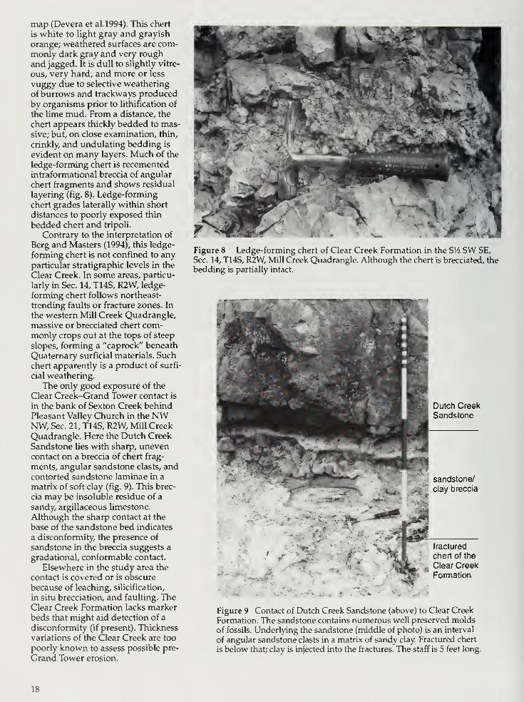
map (Devera et al.1994). This chert
is white to light gray and grayish
orange; weathered surfaces are com-monly dark gray and very roughand jagged. It is dull to slightly vitre-
ous, very hard, and more or less
vuggy due to selective weathering
of burrows and trackways produced
by organisms prior to lithification of
the lime mud. From a distance, the
chert appears thickly bedded to mas-
sive; but, on close examination, thin,
crinkly, and undulating bedding is
evident on many layers. Much of the
ledge-forming chert is recementedintraformational breccia of angular
chert fragments and shows residual
layering (fig. 8). Ledge-forming
chert grades laterally within short
distances to poorly exposed thin
bedded chert and tripoli.
Contrary to the interpretation of
Berg and Masters (1994), this ledge-
forming chert is not confined to anyparticular stratigraphic levels in the
Clear Creek. In some areas, particu-
larly in Sec. 14, T14S, R2W, ledge-
forming chert follows northeast-
trending faults or fracture zones. In
the western Mill Creek Quadrangle,
massive or brecciated chert com-monly crops out at the tops of steep
slopes, forming a "caprock" beneath
Quaternary surficial materials. Suchchert apparently is a product of surfi-
cial weathering.
The only good exposure of the
Clear Creek-Grand Tower contact is
in the bank of Sexton Creek behindPleasant Valley Church in the NWNW, Sec. 21, T14S, R2W, Mill Creek
Quadrangle. Here the Dutch Creek
Sandstone lies with sharp, unevencontact on a breccia of chert frag-
ments, angular sandstone clasts, andcontorted sandstone laminae in a
matrix of soft clay (fig. 9). This brec-
cia may be insoluble residue of a
sandy, argillaceous limestone.
Although the sharp contact at the
base of the sandstone bed indicates
a disconformity, the presence of
sandstone in the breccia suggests a
gradational, conformable contact.
Elsewhere in the study area the
contact is covered or is obscure
because of leaching, silicification,
in situ brecciation, and faulting. TheClear Creek Formation lacks markerbeds that might aid detection of a
disconformity (if present). Thickness
variations of the Clear Creek are too
poorly known to assess possible pre-
Grand Tower erosion.
Figure 8 Ledge-forming chert of Clear Creek Formation in the SVi SW SE,
Sec. 14, T14S, R2W, Mill Creek Quadrangle. Although the chert is brecciated, the
bedding is partially intact.
sandstone/
clay breccia
fractured
chert of the
Clear CreekFormation
Figure 9 Contact of Dutch Creek Sandstone (above) to Clear Creek
Formation. The sandstone contains numerous well preserved molds
of fossils. Underlying the sandstone (middle of photo) is an interval
of angular sandstone clasts in a matrix of sandy clay. Fractured chert
is below that; clay is injected into the fractures. The staff is 5 feet long.
18

Figure 10 Brecciated Dutch Creek Sandstone, consisting of angular sandstone
clasts cemented by silica and iron oxide. Location is the SE NW NW, Sec. 23,
T13S, R2W, Mill Creek Quadrangle.
Grand Tower LimestoneThe Grand Tower Limestone wasnamed for Grand Tower (Jackson
County, Illinois), which is about 10
miles northwest of the study area
(Keyes 1894). At the type locality, the
Grand Tower is predominantly light-
colored, slightly sandy, and cherty
limestone. The Dutch Creek Sand-
stone Member is at the base.
The outcrop of the Grand Towerextends due south from the center of
the north line of the Jonesboro 7.5-
Minute Quadrangle to the center of
the north line of the Mill Creek
Quadrangle, and thence south-south-
east to the Cache Valley south of
Elco. Downfaulted inliers occur west
of the main outcrop belt. There is nolimestone in the Grand Tower in
much of the study area; only the
Dutch Creek Sandstone is present.
Where limestone is present (north-
ern part of Jonesboro 7.5-Minute
Quadrangle), the Grand Tower wasmapped as a separate unit. Wherelimestone is absent, the thin DutchCreek and the overlying St. Laurent
Formation were combined as a sin-
gle map unit.
The Grand Tower thins south-
ward in the study area. Four well
logs in the northeast quarter of the
Jonesboro 7.5-Minute Quadrangle in-
dicate thicknesses of 58 to 125 feet.
In the Mill Creek Quadrangle, whereonly the Dutch Creek Sandstone is
present, the Grand Tower is only 10
to 25 feet thick. Records of four wells
in the Dongola Quadrangle, just east
of the Mill Creek Quadrangle, indi-
cate that the Grand Tower is less
than 10 to about 40 feet thick in this
area. Only two of these wells en-
countered limestone in the upperGrand Tower.
The Grand Tower Limestone in
southwestern Illinois is assigned to
the Eifelian Stage, or lower part of
the Middle Devonian Series. Theequivalent unit in western Kentuckyand southwestern Indiana is the Jef-
fersonville Limestone (Shaver 1985).
Dutch Creek Sandstone Mem-ber Savage (1920a) named the DutchCreek Sandstone for Dutch Creek in
the Jonesboro 7.5-Minute Quadran-gle. No type section was designated,
but the unit is well exposed on the
west-facing bluff near the mouth of
Dutch Creek in the NE, Sec. 19, T12S,
R2W. The Dutch Creek originally
was a separate formation, but was re-
vised to a member of the GrandTower by Meents and Swann (1965).
The Dutch Creek is white to very
light gray, very fine to mediumgrained quartz arenite, composed of
subrounded to well rounded andfrosted quartz grains. The sandstone
crops out as broken ledges, but it is
more commonly found as large
blocks displaced downslope by soil
creep. Bedding is slightly irregular
and indistinct, and generally 0.5 to 3
feet thick. Molds of fossils are pres-
ent in most exposures, particularly
spiriferid brachiopods, bivalves,
rugose corals, conularids, the prob-
lematic fossil Pleurodictyum, crinoid
stems, and poorly defined burrows.
Well samples indicate that the sand-
stone commonly has calcite cement.
The Dutch Creek commonly is
brecciated in the area of altered
rocks in the southern Jonesboro andMill Creek Quadrangles. The breccia
consists of sandstone clasts as large
as 2 feet across, as well as lesser
amounts of light-colored chert clasts,
which are cemented by silica andiron oxide (fig. 10). Clasts commonlyhave rounded corners and fit adja-
cent clasts in jigsaw-puzzle style,
showing that little fragment dis-
placement occurred after the rock
was shattered. In many outcrops,
only certain layers are brecciated
and adjacent layers are undisturbed.
Joints, where present, penetrate both
clasts and matrix. Evidently, jointing
took place after the sandstone wasbrecciated and recemented.
The Dutch Creek contains a basal
conglomerate on the south face of
Burner Hill, about 1,800 feet fromthe south line and 2,000 feet fromthe east line, Sec. 24, T14S, R2W Theconglomerate consists of scattered
angular light gray chert granules
and silicified crinoid, bryozoan, andhorn-coral fragments in a matrix of
sand cemented by iron oxide. Theconglomerate indicates a disconfor-
mity at the base of the Dutch Creek.
The Dutch Creek typically is 10 to 15
feet thick, but it reaches 25 feet. Theupper contact is gradational.
Unnamed limestone memberThe unnamed, upper limestone
member of the Grand Tower crops
out in the northern half of the Jones-
boro 7.5-Minute Quadrangle and is
present in wells east of the outcrop
belt in and near the study area. Thelower part of the limestone memberis typically white to light gray, fine
to coarse grained skeletal grainstone
that contains little, if any, silt andclay. The upper part is largely darker
colored skeletal packstone andwackestone. The limestone memberis medium to thick bedded through-
out, commonly crossbedded, andslightly cherty. Some limestone in
well cuttings contains well rounded,
frosted quartz sand, similar to that
of the Dutch Creek. Fossils include
echinoderm fragments and abun-dant whole and broken brachiopods,
19
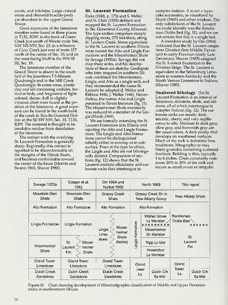
corals, and trilobites. Large crinoid
stems and chonetid brachio-pods
are abundant in the upper GrandTower.
Good exposures of the limestone
member were found in three places
in T12S, R2W: in the bank of GreenCreek just south of Illinois route 146,
NW NE NW, Sec. 23; in a tributary
of Cany Creek just east of route 127
north of the center of Sec. 10; and onthe west-facing bluff in the WVi SESE, Sec. 19.
The limestone member of the
Grand Tower is absent in the south
half of the Jonesboro 7.5-Minute
Quadrangle and in the Mill CreekQuadrangle. In some areas, plastic
clay and silt containing nodules, len-
ticular beds, and fragments of light-
colored, dense, dull to slightly
vitreous chert were found at the po-
sition of the limestone. A good expo-
sure can be found in the south bankof the creek in You-Be-Damned Hol-
low in the SE SW NW, Sec. 35, T13S,
R2W. The material is thought to beinsoluble residue from dissolution
of the limestone.
The contact with the overlying
St. Laurent Formation is generally
sharp. Regionally, this contact is
reported to be disconformable onthe margins of the Illinois Basin,
and becomes conformable towardthe center of the basin (Meents andSwann 1965, Shaver 1985).
St. Laurent FormationDake (1918, p. 175) and S. Weller
and St. Clair (1928) defined andmapped the St. Laurent Formationin Ste. Genevieve County, Missouri.
The type section comprises steeply
dipping strata, 275 feet thick, along
St. Laurent Creek. Strata equivalent
to the St. Laurent in southern Illinois
were named the Alto and Lingle For-
mations and the Misenheimer Shale
by Savage (1920a). Savage did not
map these units, and his descrip-
tions of them are sketchy. Geologists
who later mapped in southern Illi-
nois combined the Misenheimer,
Lingle, and Alto as a single unit, andthey recommended the name St.
Laurent be adopted (J. Weller andEkblaw 1940, J. Weller 1944). Never-theless, the names Alto and Lingle
persisted in Illinois literature (fig. 11).
The Misenheimer Shale eventually
was reduced to a member of the Lin-
gle (North 1969).
We are formally extending the St.
Laurent Formation into Illinois andrejecting the Alto and Lingle Forma-tions. The Lingle and Alto Forma-tions cannot be distinguished
reliably either in outcrop or in sub-
surface. Even at the type localities,
the Lingle and Alto are not lithologi-
cally distinct. Comparison of sec-
tions (fig. 12) shows that the St.
Laurent contains siliciclastic and car-
bonate rocks that intertongue in
complex fashion. It is not a layer-
cake succession, as visualized byNorth (1969) and other workers. Theonly subdivision of the St. Laurentwe could identify was the Rendle-
man Oolite Bed (fig. 11), and we are
not certain that this is a single bed.
Aconodont study by Orr (1964)
indicated that the St. Laurent ranges
from Givetian (late Middle Devon-ian) to early Frasnian (early Late
Devonian). Shaver (1985) assigned
the St. Laurent Formation to the
Givetian Stage. The St. Laurent is
equivalent to the Sellersburg Lime-stone in western Kentucky and the
North Vernon Limestone in Indiana
(Shaver 1985).
Unaltered lithology The St.
Laurent Formation is an interval of
limestone, dolomite, shale, and silt-
stone, all of which intertongue in
complex fashion (fig. 12). The car-
bonate rocks are mostly dark,
micritic, cherty, and very argilla-
ceous to silty. Medium to dark gray,
olive gray, and brownish gray are
the usual colors. A dark punky rind
develops on weathered surfaces.
Much of the rock is dolomitic lime
mudstone, lithographic to very
finely granular, containing scattered
bioclasts. Bedding is thin, typically
1 to 6 inches. Chert commonly com-poses 20% to 30% of the rock andoccurs as small ovoid or irregular
Savage 1920aCooper et al.
1942
Orr 1964 and
Norton 1966North 1969 This report
Mountain Glen
Shale
Mountain Glen
Shale
Grassy Creek
Shale
Grassy Creek Sh in
New Albany GroupNew Albany Shale
Alto Formation Alto Formation Alto Formation Alto Formation
Lingle Formation Lingle Formation
Misenheimer
Shale
St. / Misen-
Laurent ~> heimer
Fm > Shale
Lingle
Lime-
stone
Misen-
heimer
Shale
(facies)
cg
£
£CDc
Walnut Grove
Ls Member /ooooooooo
Rendleman
Oolite Beds
o o o o o o
Misenheimer
Sh Member
Tripp Ls Mbr
Howardton
Ls Member
St.
Laurent
Fm
Grand Tower
Limestone
Grand Tower
Limestone
Grand Tower
Limestone
Dutch Creek
Sandstone
Dutch Creek
Sandstone
Dutch Creek
Sandstone
Grand
."ower
LsDutch Crk
SsMbr
Grand
Tower
LsDutch Crk
SsMbr
Figure 11 Chart showing development of lithostratigraphic classification of Middle and Upper Devonianstrata in southwestern Illinois.
20

nodules and as discontinuous lay-
ers. It is dark gray to black, some-what vitreous, and dense.
A bed or lens of light gray coarse
crinoidal and oolitic grainstone 1 to
4 feet thick was observed at several
outcrops and in cuttings of several
wells (fig. 12). This is probably the
Rendleman Oolite Bed of North
(1969). Oolitic limestone generally
occurs near the middle of the St.
Laurent, near the base of a limestone
interval and overlying an interval of
shale and siltstone. The best outcrop
is in the bank of Darty Creek, 900
feet from the south line and 700 feet
from the east line of Sec. 10, T12S,
R2W, Jonesboro 7.5-Minute Quad-rangle. (The name "Darty Creek"
does not appear on the topographic
map; the creek shown at this loca-
tion bears no name. The name wasused by J. Weller and Ekblaw [1940]
and in several subsequent publica-
tions, and there is no doubt regard-
ing the location of the outcrop.)
Available data are insufficient to
show whether the oolitic limestone
represents a single bed or a series of
lenses.
The St. Laurent contains echino-
derm stems and plates, spiriferid
and chonetid brachiopods, fenestrate
bryozoans, trilobites, and rugose cor-
als. Silicified corals are abundant in
the lower part. A diagnostic fossil of
the basal St. Laurent is the "button
coral" Microcyclus discus.
Shale and siltstone constitute less
than 20% to more than 80% of the St.
Laurent in the study area. Theserocks vary from light gray, olive
gray, brownish gray, and dark gray
to nearly black; they are generally
calcareous or dolomitic, grading to
argillaceous and silty carbonate
rock. Shale and siltstone are fissile
and have well developed planar to
slightly wavy or lenticular lamina-
tions. Trace fossils (vertical and hori-
zontal burrows and escape
struc-tures) are common, but bodyfossils are rare. Some siltstone
grades to very fine grained, thinly
bedded sandstone. Dark brown to
dark gray vitreous chert nodulesand bands occur in shale and silt-
stone at some outcrops.
The succession of beds in the St.
Laurent is highly variable (fig. 12).
In general, there is more carbonate
rock in the upper portion and moreshale and siltstone in the lower por-
tion. The siliciclastic content is much
higher in the study area than else-
where in southern Illinois. Outside
of the Jonesboro Quadrangle, the St.
Laurent generally consists of argil-
laceous and silty carbonate rocks
with only thin shale interbeds.
Thickness of the St. Laurent in
the study area ranges from 80 to 200
feet, thinning southward. Region-
ally, the St. Laurent is thickest in
Union County, Illinois, and Perry
and Ste. Genevieve Counties, Mis-
souri (North 1969).
The St. Laurent is overlain discon-
formably by the New Albany Shale
or by the Springville Shale wherethe New Albany is absent. The St.
Laurent-New Albany contact is ex-
posed (digging may be necessary)
along Darty Creek, in the SW NWSW, Sec. 11, T12S, R2W. Springville
directly overlies St. Laurent in a
streambank near the center of the
south line of Sec. 1, T13S, R2W, andat the south border of the Jonesboro
7.5-Minute Quadrangle in the east
bank of the large stream in the NW,Sec. 23, T13S, R2W. At the latter out-
crop, the upper surface of the St.
Laurent is thickly encrusted with a
botryoidal black mineral thought to
be manganese oxide.
Altered lithology Carbonate
rocks have been dissolved and silt-
stones and shales bleached in the
area of altered rocks, as indicated onthe geologic maps of Nelson andDevera (1994) and Devera et al.
(1994). Shales typically are dull
white to light yellowish gray, locally
mottled, and banded with pale
green, pink, and violet. Laminationand fissility are preserved. Mostaltered rock is very porous and lowin density. Such rock probably wasoriginally limestone or dolomite
with a high silt/clay content. Darkbrownish gray vitreous chert layers
and nodules are common in altered
St. Laurent. The St. Laurent is diffi-
cult to distinguish from the Spring-
ville Shale in areas where it has beenstrongly altered.
New Albany ShaleThe Upper Devonian/Kinder-hookian black shale in southern Illi-
nois has been alternatively called
Chattanooga, Mountain Glen,
Grassy Creek, and New AlbanyShale by various geologists. Thename New Albany Shale (Borden
1874) has priority and is accepted bymost recent authors. Although some
geologists (e.g., Collinson et al. 1967,
Cluff et al. 1981) classify the NewAlbany as a group in Illinois, it is
ranked as a formation in this report
because it cannot be subdivided.
The New Albany is very darkgray to black, brittle, highly fissile,
siliceous or finely silty shale. It weath-
ers to dark olive gray or brownishgray and splits into paper-thin lay-
ers. The uppermost 1 foot of the
shale is less fissile and is mottled in
dark greenish gray and olive gray.
The only common fossil is Tasman-
ites, an algal test that is called
"spores" or "Sporangites" in manysample logs and older reports.
A very thin sandstone or sandyzone occurs locally at the base of the
New Albany. Several authors called
this zone the Sylamore Sandstone at
formation rank (Collinson and Scott
1958, Collinson and Atherton 1975,
Cluff et al. 1981). Clearly, a unit that
is only a few inches thick should not
be classified as a formation. TheSylamore Sandstone in southern Illi-
nois is herein revised to the Syla-
more Sandstone Bed in the NewAlbany Shale. Exposures of the Syla-
more Bed are reported in the bank of
Darty Creek, in the SE SE, Sec. 10,
T12S, R2W, Jonesboro 7.5-Minute
Quadrangle (Collinson and Scott
1958), and the bank of Clear Creekin the NV4 NE NE, Sec. 34, T11S,
R2W, Cobden Quadrangle (Orr 1964,
p. 3). Digging is required to reveal
these occurrences.
The New Albany is absent in
most of the area of altered rocks. Theonly New Albany we observed in
the altered area was float in a stream
bank near the center of the east line
of Sec. 2, T14S, R2W, and shale that
had been cast out from a manmadepit about 0.5 mile south of the
stream. The shale at those places
did not differ noticeably from nor-
mal New Albany.
The New Albany is 55 feet or thin-
ner in most of the study area, but it
may reach 80 feet in Sec. 29, T12S,
R2W (fig. 13). The New Albany is
absent as a result of pre-Springville
erosion in the southeastern Jones-
boro 7.5-Minute Quadrangle and in
most of the Mill Creek Quadrangle.Eastward, in the Dongola Quadran-gle, the New Albany thickens to 50
to 110 feet. About 60 miles east of the
study area, the New Albany reaches
a maximum of more than 450 feet
(Cluff etal. 1981).
21
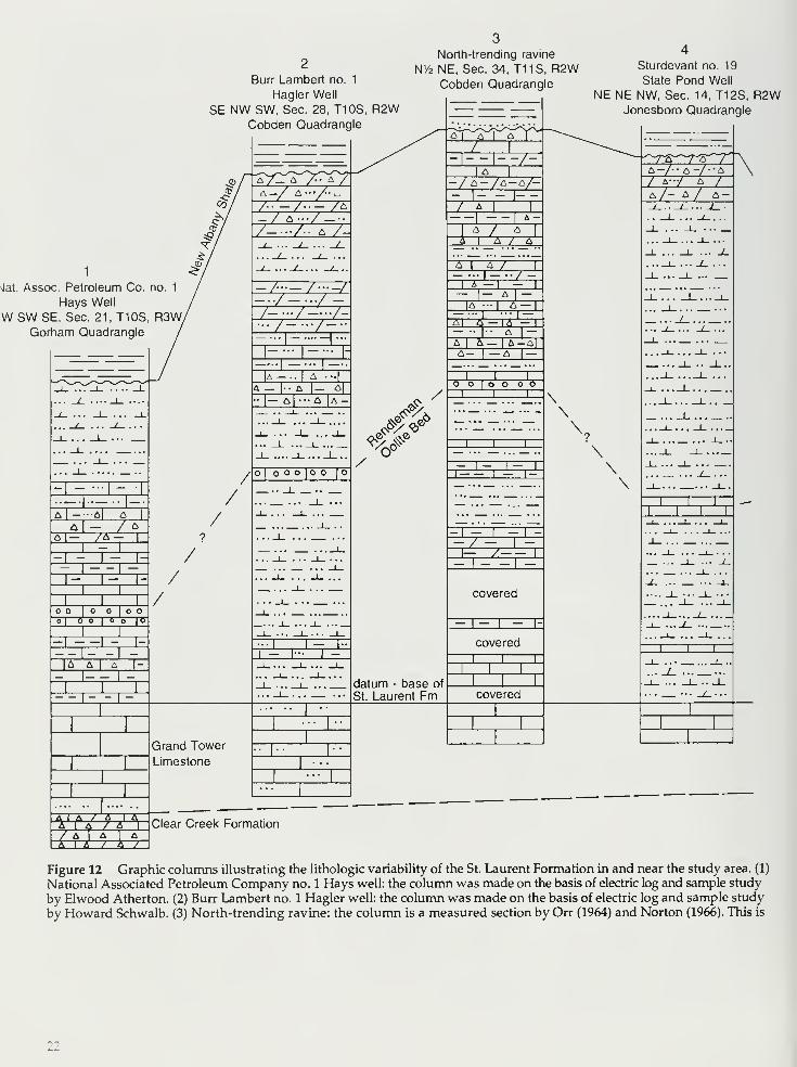
Burr Lambert no. 1
Hagler Well
SE NW SW, Sec. 28, T10S, R2WCobden Quadrangle
North-trending ravine
N 1/2 NE, Sec. 34, T11S, R2WCobden Quadrangle
p1
slat. Assoc. Petroleum Co. no. 1
Hays Well
W SW SE, Sec. 21, T10S, R3W/Gorham Quadrangle
a|-a| al>l - zxal- /A- T
I - I
I- I-
Io | o o
o |O [ O TO
-
A A | a ~F- I- - I -
--I- ~
Bj^.W
A I A Z ±
//
/
//
/
Grand Tower
Limestone
a-/ a-77
/!.. /..^ /J
.^_..^^^^^A — .. A
4 - • a - a— A • A A -
0° O 10 O |o
.<-*#
/
%^e
/
datum - base of
St. Laurent Fm
A| A I
A7~^~
T^TZE
/ 5 1 5Ta I a / a
.*/ I
--I---/A -I - I
Ia'-I A-lsi a-ia^=~t
A I A— I A-AlA— A —
o o loo oo"I I
,
-I
-, I
- /- -
covered
covered
r-rcovered
Sturdevant no. 19
State Pond Well
NE NE NW, Sec. 14, T12S, R2WJonesboro Quadrangle
\\\.
\\\
-/••ft-/-~rv77A-/ A
a/- A/ fr-
ill
Clear Creek Formation
Figure 12 Graphic columns illustrating the lithologic variability of the St. Laurent Formation in and near the study area. (1)
National Associated Petroleum Company no. 1 Hays well: the column was made on the basis of electric log and sample study
by Elwood Atherton. (2) Burr Lambert no. 1 Hagler well: the column was made on the basis of electric log and sample study
by Howard Schwalb. (3) North-trending ravine: the column is a measured section by Orr (1964) and Norton (1966). This is
::

1»2» 5 mi
I1
—
'
5 km
Roadcut ravine on south side
of Route 146
NE NE NW, Sec. 23, T12S, R2WJonesboro Quadrangle
__?•
covered
covered
| FaE ^~p
covered
- I- I-
-u i--i-
l
-.-l-
i - i
-o | o o | o o | o
i b ia &—nr
Rigney no. 1
Hileman Well
NW SE SW, Sec. 21, T13S, R1WDongola Quadrangle
Bend\eraao
OoWeSS Bed
—_^: .7^- r!~.
_ A ..-/ ••• -/••
A |"— /A — | AA A —
| A •
I- A j-A /-A !••• a
Ia —
/ & I- M -
•I A •••
| A-I- A I o~oT=
O 0| O O I
i r
aIa aTfl
I S • •Ima 7TTAl
Jonesboro :
: 15-Minute
Quadrangle >•
• 6
Streambed and adjacent
hillside, Lingle Creek
Vz SW SW, Sec. 26, T13S, R2WMill Creek Quadrangle
Springville
Shale
poorly exposedand structurally
complex
A I A I A A I
A A I A |A^A A
A I
It AI B
A I A A | A
0-rO
10-
20-
30-_
40-
50 ft -Ll5 m
-5
-10
Clear Creek Formation
the type section of the Alto Formation (Savage 1920a). (4) Sturdevant no. 19 State Pond well: the column was made on the
basis of sample study by George Ekblaw (5) Roadcut and ravine: the measured section is by Norton (1966) and W.J. Nelson.
(6) Rigney no. 1 Hileman well: the column was made on the basis of sample study by Elwood Atherton. (7) Streambed andadjacent hillside: the measured section is by Norton (1966). This is the type section of the Lingle Formation (Savage 1920a).
OCT 2 9 1996
II uluu ouKVEY 23
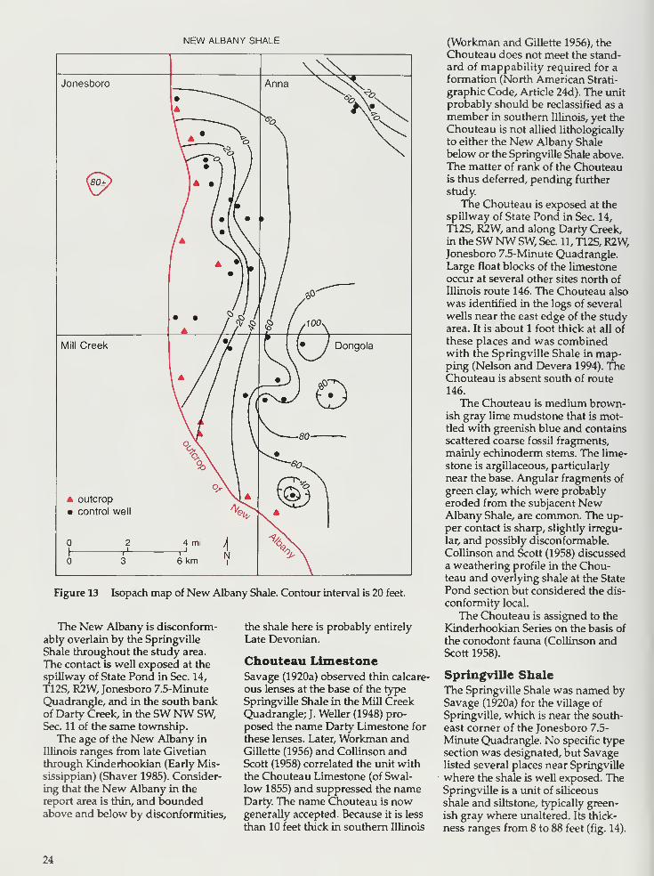
NEW ALBANY SHALE
Figure 13 Isopach map of New Albany Shale. Contour interval is 20 feet.
The New Albany is disconform-
ably overlain by the Springville
Shale throughout the study area.
The contact is well exposed at the
spillway of State Pond in Sec. 14,
T12S, R2W, Jonesboro 7.5-Minute
Quadrangle, and in the south bankof Darty Creek, in the SW NW SW,Sec. 11 of the same township.
The age of the New Albany in
Illinois ranges from late Givetian
through Kinderhookian (Early Mis-sissippian) (Shaver 1985). Consider-
ing that the New Albany in the
report area is thin, and boundedabove and below by disconformities,
the shale here is probably entirely
Late Devonian.
Chouteau LimestoneSavage (1920a) observed thin calcare-
ous lenses at the base of the type
Springville Shale in the Mill CreekQuadrangle; J. Weller (1948) pro-
posed the name Darty Limestone for
these lenses. Later, Workman andGillette (1956) and Collinson andScott (1958) correlated the unit with
the Chouteau Limestone (of Swal-
low 1855) and suppressed the nameDarty. The name Chouteau is nowgenerally accepted. Because it is less
than 10 feet thick in southern Illinois
(Workman and Gillette 1956), the
Chouteau does not meet the stand-
ard of mappability required for a
formation (North American Strati-
graphic Code, Article 24d). The unit
probably should be reclassified as a
member in southern Illinois, yet the
Chouteau is not allied lithologically
to either the New Albany Shale
below or the Springville Shale above.
The matter of rank of the Chouteauis thus deferred, pending further
study.
The Chouteau is exposed at the
spillway of State Pond in Sec. 14,
T12S, R2W, and along Darry Creek,
in the SWNW SW, Sec. 11, T12S, R2W,Jonesboro 7.5-Minute Quadrangle.Large float blocks of the limestone
occur at several other sites north of
Illinois route 146. The Chouteau also
was identified in the logs of several
wells near the east edge of the studyarea. It is about 1 foot thick at all of
these places and was combinedwith the Springville Shale in map-ping (Nelson and Devera 1994). TheChouteau is absent south of route
146.
The Chouteau is medium brown-ish gray lime mudstone that is mot-tled with greenish blue and contains
scattered coarse fossil fragments,
mainly echinoderm stems. The lime-
stone is argillaceous, particularly
near the base. Angular fragments of
green clay, which were probablyeroded from the subjacent NewAlbany Shale, are common. The up-
per contact is sharp, slightly irregu-
lar, and possibly disconformable.
Collinson and Scott (1958) discussed
a weathering profile in the Chou-teau and overlying shale at the State
Pond section but considered the dis-
conformity local.
The Chouteau is assigned to the
Kinderhookian Series on the basis of
the conodont fauna (Collinson andScott 1958).
Springville ShaleThe Springville Shale was named bySavage (1920a) for the village of
Springville, which is near the south-
east corner of the Jonesboro 7.5-
Minute Quadrangle. No specific type
section was designated, but Savagelisted several places near Springville
where the shale is well exposed. TheSpringville is a unit of siliceous
shale and siltstone, typically green-
ish gray where unaltered. Its thick-
ness ranges from 8 to 88 feet (fig. 14).
24

State Pond Member The State
Pond Member of the Springville
Shale is a thin unit of soft greenish
shale that directly overlies the
Chouteau Limestone at the spillway
of State Pond, in the SW NW SW,Sec. 14, T12S, R2W, Jonesboro 7.5-
Minute Quadrangle (Collinson andScott 1958). The member occurs else-
where in the study area but is poorly
exposed. It is composed of clay shale
that is bright green to dark greenish
or olive gray, mottled, soft, andslightly calcareous. Black, phos-
phatic (?) pebbles occur in the State
Pond Member at the type locality. Afew inches of quartz sandstone are
at the base of the State Pond whereit disconformably overlies the St.
Laurent Formation southwest of
Kornthal Church, in the SE SE SW,Sec. 1, T13S, R2W, Jonesboro 7.5-
Minute Quadrangle. The State PondMember is 1 to 5 feet thick andgrades into overlying silty shale of
the upper member of the Springville.
Collinson and Scott (1958) re-
ported that the State Pond Membercontains conodonts indicating earli-
est Valmeyeran age.
Upper member The upper (un-
named) member of the Springville
Shale makes up 90% or more of the
thickness of the formation. In areas
where it is not altered, the uppermember is composed of mediumgreenish gray to bluish gray silty or
siliceous shale and siltstone. This
rock is slightly fissile to blocky andoccurs in irregular or lenticular lay-
ers 1 to 2 inches thick. The rock
coarsens upward, and layering be-
comes thicker toward the top. Mostof the shale and siltstone is onlyslightly calcareous, but the upperpart approaches a silty limestone in
some areas (e.g., along Darty Creek).
Trace fossils, consisting of small bur-
rows and trails, are uncommon; nobody fossils were found. In places,
the lower part contains discontinu-
ous layers of clay shale that weath-ers chocolate brown to purplish
brown. Small quartz-filled vugsoccasionally can be found in the
upper part of the Springville.
Good exposures of the uppermember can be seen at the DartyCreek and State Pond localities, as
well as in a roadcut and adjacent
abandoned shale pit in the NE,Sec. 23, T12S, R2W. Outcrops also
are common along the creek south-
SPRINGVILLE SHALE
Figure 14 Isopach map of Springville Shale. Contour interval is 20 feet.
west of Kornthal Church in Sec. 1,
T13S, R2W. The upper contact is ex-
posed just south of the church, andthe lower contact just east of the
road junction near the south line of
Seel.The contact with the overlying
Fort Payne Formation is well ex-
posed in many places, and it is in-
variably sharp and planar or slightly
uneven. As Collinson and Scott
(1958) reported, this contact prob-
ably is disconformable. The top of
the Springville was used as struc-
tural datum on the Jonesboro geo-
logic map (Nelson and Devera 1994).
The Springville is 35 to 75 feet
thick at most places in the study
area; however, it ranges from 8 to 88
feet thick in the area. A comparison v
of the Springville (fig. 14) and NewAlbany isopachs (fig. 13) shows that
the Springville commonly is thin in
areas where the New Albany is thick
and vice versa. This pattern indicates
that the Springville filled depres-
sions eroded into the New Albany.
The upper member of the Spring-
ville Shale is assigned to the lower
part of the Valmeyeran Series (Col-
linson and Scott 1958, Shaver 1985).
25
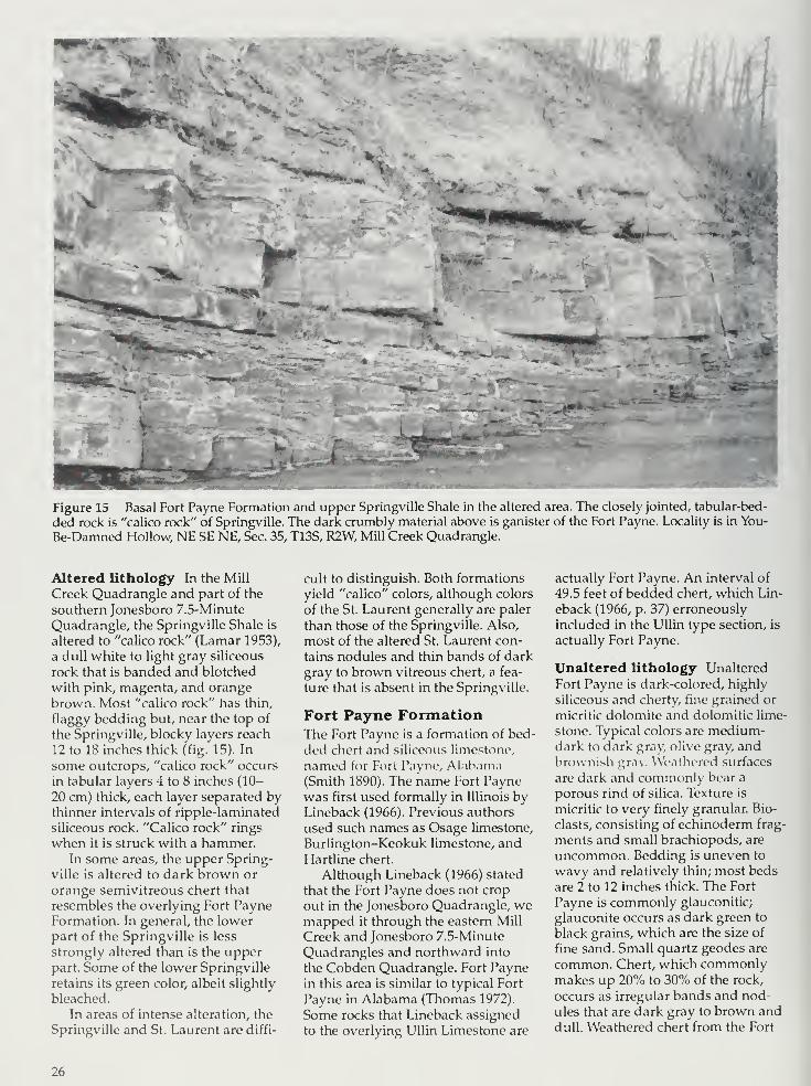
""9****.
Figure 15 Basal Fort Payne Formation and upper Springville Shale in the altered area. The closely jointed, tabular-bed-
ded rock is "calico rock" of Springville. The dark crumbly material above is ganister of the Fort Payne. Locality is in You-
Be-Damned Hollow, NE SE NE, Sec. 35, TBS, R2W, Mill Creek Quadrangle.
Altered lithology In the Mill
Creek Quadrangle and part of the
southern Jonesboro 7.5-Minute
Quadrangle, the Springville Shale is
altered to "calico rock" (Lamar 1953),
a dull white to light gray siliceous
rock that is banded and blotched
with pink, magenta, and orange
brown. Most "calico rock" has thin,
flaggy bedding but, near the top of
the Springville, blocky layers reach
12 to 18 inches thick (fig. 15). In
some outcrops, "calico rock" occurs
in tabular layers 4 to 8 inches (10-
20 cm) thick, each layer separated bythinner intervals of ripple-laminated
siliceous rock. "Calico rock" rings
when it is struck with a hammer.In some areas, the upper Spring-
ville is altered to dark brown or
orange semivitreous chert that
resembles the overlying Fort PayneFormation. In general, the lowerpart of the Springville is less
strongly altered than is the upperpart. Some of the lower Springville
retains its green color, albeit slightly
bleached.
In areas of intense alteration, the
Springville and St. Laurent are diffi-
cult to distinguish. Both formations
yield "calico" colors, although colors
of the St. Laurent generally are paler
than those of the Springville. Also,
most of the altered St. Laurent con-
tains nodules and thin bands of dark
gray to brown vitreous chert, a fea-
ture that is absent in the Springville.
Fort Payne FormationThe Fort Payne is a formation of bed-
ded chert and siliceous limestone,
named for Fori Payne, Alabama(Smith 1890). The name Fort Paynewas first used formally in Illinois byLineback (1966). Previous authors
used such names as Osage limestone,
Burlington-Keokuk limestone, andHartline chert.
Although Lineback (1966) stated
that the Fort Payne does not crop
out in the Jonesboro Quadrangle, wemapped it through the eastern Mill
Creek and Jonesboro 7.5-Minute
Quadrangles and northward into
the Cobden Quadrangle. Fort Paynein this area is similar to typical Fort
Payne in Alabama (Thomas 1972).
Some rocks that Lineback assigned
to the overlying Ullin Limestone are
actually Fort Payne. An interval of
49.5 feet of bedded chert, which Lin-
eback (1966, p. 37) erroneously
included in the Ullin type section, is
actually Fort Payne.
Unaltered lithology Unaltered
Fort Payne is dark-colored, highly
siliceous and cherry, fine grained or
micritic dolomite and dolomitic lime-
stone. Typical colors are medium-dark to dark gray, olive gray andbrownish gray. Weathered surfaces
are dark and commonly bear a
porous rind of silica. Texture is
micritic to very finely granular. Bio-
clasts, consisting of echinoderm frag-
ments and small brachiopods, are
uncommon. Bedding is uneven to
wavy and relatively thin; most beds
are 2 to 12 inches thick. The Fort
Payne is commonly glauconitic;
glauconite occurs as dark green to
black grains, which are the size of
fine sand. Small quartz geodes are
common. Chert, which commonlymakes up 20% to 30% of the rock,
occurs as irregular bands and nod-
ules that are dark gray to brown anddull. Weathered chert from the Fort
26

Figure 16 Siliceous limestone of the Fort Payne Formation cropping out north of Lingle Creek near the center of the SW,Sec. 30, T13S, R1W. This is a typical exposure of unaltered Fort Payne in the Mill Creek Quadrangle.
Payne is light to medium brownishgray and has coarse, wavy bandingthat resembles wood grain. In the
northern Mill Creek Quadrangle, the
Fort Payne commonly forms ledges,
and weathered surfaces are roughand jagged. Weathering accentuates
the layering, which is faint in fresh
exposures (fig. 16). At unweatheredexposures (such as the abandonedquarry near Illinois route 127 in the
NE SW SW, Sec. 19, T13S, R1W), the
Fort Payne is thick bedded lime-
stone that has shaley partings spaced
1 to 3 feet apart.
Other good exposures of Fort
Payne can be found in several areas:
the bank of Darty Creek in the NWSW, Sec. 11, T12S, R2W; the roadcut
along Illinois route 146 in the NENE, Sec. 23, T12S, R2W; the stream-
bed just south of Kornthal Churchnear the center of the EVi, Sec. 1,
T13S, R2W; and the south bank of
the east-flowing stream in the SWSE,Sec. 13,T13S,R2W.
Contrary to the findings of Line-
back (1966), the contact with the
overlying Ullin Limestone is transi-
tional throughout the study area.
Dark, very siliceous lime mudstone
of the Fort Payne gradually changesupward to medium gray, very fine
to fine grained skeletal limestone
that contains less chert and dissemi-
nated silica. Intertonguing Fort
Payne and Ullin can be seen in out-
crops near the boundary of the
Jonesboro and Mill Creek 7.5-Minute
Quadrangles. In this area, the Fort
Payne thickens southward from less
than 20 feet to more than 100 feet
within a distance of 0.5 mile.
The Fort Payne is thinnest, 15 feet
or less, in the southeastern Jones-
boro 7.5-Minute Quadrangle (fig. 17).
In the northeastern Jonesboro Quad-rangle, it thickens to 50 to 110 feet.
The Fort Payne is 100 to 140 feet
thick in the northeastern Mill CreekQuadrangle; a few miles farther
east, well records show it to be 300
or more feet thick.
Altered lithology The altered
Fort Payne Formation is composedof dense, hard, bedded chert and a
granular form of microcrystalline
silica, commonly called ganister.
The bedded chert is mottled or
banded in brownish gray to orangegray. Banding is ropey or resembles
coarse wood grain. Chert is dull to
slightly vitreous, dense to slightly
vesicular, and commonly contains
small quartz geodes. Beds are gener-
ally tabular and range from 1 to 24
inches thick, but most are 6 to 18
inches thick. The basal part is moststrongly silicified.
Ganister (Lamar 1953) is granular,
pelletal, and very porous. It is red-
dish orange, dark red, or burntorange in most exposures, but it is
white to light gray in some areas. It
is more difficult to dig ganister fromthis formation than it is to dig tripoli
from the Clear Creek Formation.
The thin layering of the Fort Payneis preserved in ganister. Occasional
layers of sticky orange to brown clay
are present. Ganister grades laterally
to unaltered siliceous limestone andbedded chert. Ganister grades to
limestone along the bluff south of
Lingle Creek in the SW SW, Sec. 30,
T13S, R1W, Mill Creek Quadrangle.Ganister grades to bedded chert in
roadcuts along Illinois route 127 just
north of Elco, and also near aban-doned ganister mines in the hills
east of Elco.
27
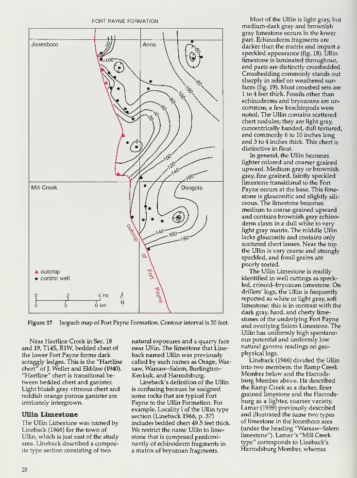
FORT PAYNE FORMATION
Figure 17 Isopach map of Fort Payne Formation. Contour interval is 20 feet.
Near Hartline Creek in Sec. 18
and 19, T14S, R1W, bedded chert of
the lower Fort Payne forms dark
scraggly ledges. This is the "Hartline
chert" of J. Weller and Ekblaw (1940).
"Hartline" chert is transitional be-
tween bedded chert and ganister.
Light bluish gray vitreous chert andreddish orange porous ganister are
intricately intergrown.
Ullin LimestoneThe Ullin Limestone was named byLineback (1966) for the town of
Ullin, which is just east of the studyarea. Lineback described a compos-ite type section consisting of two
natural exposures and a quarry face
near Ullin. The limestone that Line-
back named Ullin was previously
called by such names as Osage, War-saw, Warsaw-Salem, Burlington-
Keokuk, and Harrodsburg.
Lineback's definition of the Ullin
is confusing because he assigned
some rocks that are typical Fort
Payne to the Ullin Formation. For
example, Locality 1 of the Ullin type
section (Lineback 1966, p. 37)
includes bedded chert 49.5 feet thick.
We restrict the name Ullin to lime-
stone that is composed predomi-nantly of echinoderm fragments in
a matrix of bryozoan fragments.
Most of the Ullin is light gray, butmedium-dark gray and brownishgray limestone occurs in the lowerpart. Echinoderm fragments are
darker than the matrix and impart a
speckled appearance (fig. 18). Ullin
limestone is laminated throughout,
and parts are distinctly crossbedded.
Crossbedding commonly stands outsharply in relief on weathered sur-
faces (fig. 19). Most crossbed sets are
1 to 4 feet thick. Fossils other than
echinoderms and bryozoans are un-common; a few brachiopods werenoted. The Ullin contains scattered
chert nodules; they are light gray,
concentrically banded, dull textured,
and commonly 6 to 10 inches long
and 3 to 4 inches thick. This chert is
distinctive in float.
In general, the Ullin becomeslighter colored and coarser grainedupward. Medium gray or brownishgray, fine grained, faintly speckled
limestone transitional to the Fort
Payne occurs at the base. This lime-
stone is glauconitic and slightly sili-
ceous. The limestone becomesmedium to coarse-grained upwardand contains brownish gray echino-
derm clasts in a dull white to verylight gray matrix. The middle Ullin
lacks glauconite and contains only
scattered chert lenses. Near the top
the Ullin is very coarse and strongly
speckled, and fossil grains are
poorly sorted.
The Ullin Limestone is readily
identified in well cuttings as speck-
led, crinoid-bryozoan limestone. Ondrillers' logs, the Ullin is frequently
reported as white or light gray, soft
limestone; this is in contrast with the
dark gray, hard, and cherry lime-
stones of the underlying Fort Payneand overlying Salem Limestone. TheUllin has uniformly high spontane-
ous potential and uniformly lownatural gamma readings on geo-
physical logs.
Lineback (1966) divided the Ullin
into two members: the Ramp CreekMember below and the Harrods-burg Member above. He described
the Ramp Creek as a darker, finer
grained limestone and the Harrods-
burg as a lighter, coarser variety.
Lamar (1959) previously described
and illustrated the same two types
of limestone in the Jonesboro area
(under the heading "Warsaw-Salemlimestone"). Lamar's "Mill Creektype" corresponds to Lineback's
Harrodsburg Member, whereas
28

Lamar's "Kornthal type" matchesLineback's Ramp Creek. As Lamarobserved, the two types of limestone
intertongue with one another. Thebest place to see intertonguing of
Harrodsburg and Ramp Creek is at
the Ullin Quarry of the ColumbiaQuarry Company. This quarry con-
tains part of the Ullin type section.
Furthermore, the Ramp Creek lithol-
ogy is transitional between the Fort
Payne and the Harrodsburg, andintertongues with both. The Harrods-
burg and Ramp Creek are better clas-
sified as facies than as members.The outcrop belt of the Ullin lies
mostly east of the area of altered
rocks. A few inliers of Ullin werefound near the east margin of the
altered area. (They are mapped as
Mississippian-Devonian undivided.)
Altered Ullin consists of blocks of
light gray, banded chert and lime-
stone in a matrix of plastic clay. Evi-
dently, most of the limestone wasdissolved in the altered area.
Thickness of the Ullin, as indi-
cated by borehole data, ranges from225 to 490 feet. The Ullin averages
345 feet thick in the wells that have
the most reliable logs.
The Ullin-Salem contact appears
sharp in some exposures, but beds
of Ullin lithology occur in the lower
Salem, indicating intertonguing.
Such interbedding was observed in
gullies southeast of Darty Creek, in
the center SW NE, Sec. 11, T12S,
R2W, and a streambed and roadcut
in the SE NE, Sec. 6, T13S, R1W. Sam-ple logs of wells in the Anna Quad-rangle also indicate intertonguing.
The top of the Ullin was mapped at
the base of the lowest dark lime-
stone of Salem lithology.
Salem LimestoneThe Salem Limestone was named byCumings (1901) for Salem, Indiana,
where the limestone is quarried for
building stone. In its type area, the
Salem is largely light gray oolitic
grainstone that exhibits large-scale
crossbedding. In other areas, a widevariety of limestone lithologies are
assigned to the Salem. For example,dark gray to black, argillaceous,
and dolomitic lime mudstone wasmapped as Salem in the Fluorspar
District (Baxter and Desborough1965, Baxter et al. 1967). The SalemLimestone seems to be a catch-all for
strata between the Ullin (or equiva-
lent) and St. Louis Limestones,
Figure 18 Crosslaminated Ullin Limestone (Jonesboro Quarry), showing the
typical "speckled" appearance of the limestone, which is caused by darker cri-
noid fragments in a lighter matrix. Staff is graduated in feet and inches.
Figure 19 Large-scale planar crossbedding in upper Ullin Limestone at the
Columbia Quarry Company's Jonesboro Quarry, just east of the study area in the
SE NE, Sec. 17, T13S, R1VV, Anna Quadrangle. Staff is graduated in feet and inches.
whose lithologic characters are morenarrowly constrained.
In this study area, the Salem is a
unit of medium to dark-colored lime-
stone that ranges from lime mud-stone to grainstone but most com-monly is packstone. Darker color,
finer texture, presence of oolites, andlack of crossbedding distinguish the
Salem from the Ullin. The overlying
St. Louis Limestone differs from the
Salem in that it is predominantly
lime mudstone and fine grained
skeletal limestone having few or nooolites and much chert.
Two informal units make up the
Salem in the Jonesboro Quadrangle.
The lower unit, which makes up one-
quarter to one-third of the formation,
is interbedded dark micritic lime-
stone and light skeletal limestone.
The dark limestones are argillaceous
to silty, partly dolomitic lime mud-stones and wackestones. They are
29
very thin or thinly bedded and con-
tain numerous nodules and discon-
tinuous layers of light grayish
brown chert. The light-colored lime-
stones are fine to coarse grained
skeletal packstones and grainstones,
which are generally poorly sorted
and sparingly oolitic. Fossil frag-
ments include echinoderms, brachi-
opods, and bryozoans. In contrast to
the Ullin, where darker crinoid frag-
ments stand out against a white ma-trix, fossil grains in the lower Salemare generally lighter than the matrix.
Light-colored lower Salem limestones
are relatively pure carbonate contain-
ing little chert, and bedding ranges
from thin to thick.
The upper unit of the Salem Lime-
stone is predominantly medium to
dark gray and brownish gray, fine to
coarse grained skeletal packstone
and wackestone. Fossil fragments
are poorly sorted, partly rounded,
and oolitically coated. Bedding is
generally 1 to 3 feet thick. The upperSalem is at most slightly argillaceous
and contains only a few chert nod-ules. Whole fossils are rare except
near the top, where silicified rugose
corals are common. The diagnostic
fossil for the uppermost Salem andbasal St. Louis is the "finger coral,"
Acrocyathus proliferus,which was called
Lithostrotionella proliferum in manyolder reports; its present classifica-
tion was established by Sando (1983).
The Salem-St. Louis contact is
gradational and intertonguing. Bedsof skeletal packstone, typical of the
Salem, alternate with beds of typical
St. Louis cherty lime mudstone in
the contact zone. Exposures of the
contact are east of State Pond in the
SE SE, Sec. 12, T12S, R2W, and in ra-
vines south of Anna in the EVi NE,Sec. 30, T12S, R1W. Intertonguing
and lateral gradation of the Salemand St. Louis Limestones previously
were documented by Lineback
(1972). In the field, we mapped the
Salem-St. Louis contact at the low-
est occurrence of lime mudstone.Thickness of the Salem Lime-
stone, as determined by well records
in the Jonesboro and western Anna7.5-Minute Quadrangles, ranges
from 285 to 435 feet.
St. Louis LimestoneEnglemann (1847) named the St.
Louis Limestone for St. Louis, Mis-
souri. Concise definitions of the St.
Louis Limestone are difficult to find.
In general, the St. Louis is an inter-
val of micritic to fine grained, cherty
limestone and dolomite. Rocks fit-
ting this description in the studyarea are mapped as St. Louis.
The most distinctive rock type in
the St. Louis is thick bedded, cherty,
dolomitic, micritic lime mudstonethat breaks with conchoidal fracture.
This rock type is commonly called
"sublithographic." It is typically
medium gray or brownish gray onfresh surfaces and weathers to
lighter shades of gray and olive
gray. Some chert is light gray, but
most of it is dark bluish gray to
nearly black and vitreous; it occurs
as large lenses and discontinuous
bands. Also common are small vugsand geodes filled with white sparry
calcite and drusy quartz.
Alternating with lime mudstoneare beds of medium to dark gray,
very finely to finely granular lime-
stone. Some of these beds are skele-
tal wackestones and packstones
similar to those of the upper Salem,
whereas other beds are recrystal-
lized mudstones that contain few or
no fossil fragments. Oolites are rare.
Fossils include brachiopods, Mas-toids, crinoids, and rugose corals.
Acrocyathus proliferus is abundant in
the basal St. Louis.
Light gray, fine grained skeletal
limestones dominate in the upperpart of the St. Louis. Occasional
silicified colonies of Acrocyathus
floriformis (found mainly as float) are
present.
Good outcrops of the St. Louis
can be found along the road andstream in Kratzinger Hollow in
small roadcuts and in two small,
abandoned limestone quarries north
of the road in the hollow. Outcropsalso can be found near the heads of
several ravines north of Kratzinger
Hollow. The basal St. Louis is well
exposed in several small ravines just
south of Anna.The contact with the overlying
Ste. Genevieve Limestone is transi-
tional and arbitrary. Other geologists
mapped this contact at (1) the lowest
occurrence of light-colored oolitic
limestone, (2) the highest occurrence
of chert, (3) the highest occurrence
of "lithostrotionellid" corals, or (4) a
combination of the above (Atherton
et al. 1975, Sable and Dever 1990). In
the Jonesboro area, cherty lime-
stone occurs throughout the Ste.
Genevieve, so the contact cannot be
based on chert. The most practical
place for the contact in this area is
the lowest occurrence of oolitic lime-
stone. Because the St. Louis/Ste.
Genevieve transition is poorly ex-
posed in the study area, the two for-
mations were combined as a single
unit in the Jonesboro 7.5-Minute
Quadrangle (Nelson and Devera1994). The only place where the con-
tact can be located closely is near the
head of Kratzinger Hollow in the
NW SE, Sec. 18, T12S, R1W.The St. Louis is approximately
100 feet thick in Kratzinger Hollow,the only place where both contacts
can be located accurately. Samplelogs from five water wells in the city
of Anna indicate the St. Louis to befrom 70 to 140 feet thick. The forma-
tion thickens eastward to 250 feet in
wells in the eastern part of the Anna7.5-Minute Quadrangle. A regional
isopach map of the St. Louis in
southern Illinois shows that the St.
Louis thickens eastward to morethan 500 feet in southeastern Illinois
(Atherton et al. 1975, p. 141).
Ste. Genevieve LimestoneThe Ste. Genevieve Limestone wasnamed for Ste. Genevieve, Missouri,
by Shumard (1859). This formation
generally is recognized as an inter-
val that is dominated by light-col-
ored oolitic and skeletal limestones.
It contains lesser amounts of micritic
limestone, shale, and sandstone.
The outcrop belt of the Ste.
Genevieve crosses the northeast cor-
ner of the Jonesboro 7.5-Minute
Quadrangle. This is an area of gen-
tly rolling topography and numeroussinkholes. Outcrops are few andsmall in the Jonesboro Quadrangle,
but a nearly complete section can beseen at the active Anna Quarry just
east of the study area. Information
given here is derived mainly fromthese quarry exposures and is sup-
plemented by data from nearby out-
crops, core descriptions, and samplelogs of water wells.
The Ste. Genevieve contains sev-
eral types of limestone that are inter-
bedded. (1) Roughly half the forma-
tion is white to light gray oolitic andskeletal grainstone that is typically
crossbedded. This rock occurs in in-
tervals 4 to 20 feet thick and is rela-
tively soft and lacks chert. (2) Abouta quarter of the formation is light to
medium gray and brownish gray,
fine grained skeletal grainstone,
30
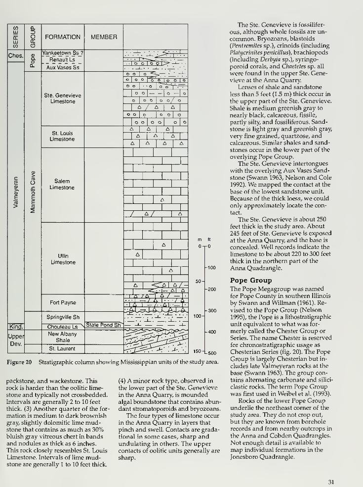
coUJ
DCLUCO
Ches.
DOtrCD
CDQ.O0.
FORMATION
Yapkeetown Ss_?
Renault Ls
Aux Vases Ss
Ste. GenevieveLimestone
St. Louis
Limestone
MEMBER
^ ^-T-^-
1° °l*o (lo o I o
o o • o o o
oI
O oJo o/ o
A / Ao o o o o o
o o o o o o
A~ A | A[
1 g 1 4 I
A1
50
100
-100
-200
300
-400
150-
Figure 20 Stratigraphic column showing Mississippian units of the study
t-500
area.
packstone, and wackestone. This
rock is harder than the oolitic lime-
stone and typically not crossbedded.
Intervals are generally 2 to 10 feet
thick. (3) Another quarter of the for-
mation is medium to dark brownishgray, slightly dolomitic lime mud-stone that contains as much as 30%bluish gray vitreous chert in bandsand nodules as thick as 6 inches.
This rock closely resembles St. Louis
Limestone. Intervals of lime mud-stone are generally 1 to 10 feet thick.
(4) A minor rock type, observed in
the lower part of the Ste. Genevievein the Anna Quarry, is moundedalgal boundstone that contains abun-
dant stromatoporoids and bryozoans.
The four types of limestone occur
in the Anna Quarry in layers that
pinch and swell. Contacts are grada-
tional in some cases, sharp andundulating in others. The uppercontacts of oolitic units generally are
sharp.
The Ste. Genevieve is fossilifer-
ous, although whole fossils are un-
common. Bryozoans, blastoids
(Pentremites sp.), crinoids (including
Platycrinites penicillus), brachiopods
(including Derbyia sp.), syringo-
poroid corals, and Chaetetes sp. all
were found in the upper Ste. Gene-vieve at the Anna Quarry.
Lenses of shale and sandstone
less than 5 feet (1.5 m) thick occur in
the upper part of the Ste. Genevieve.
Shale is medium greenish gray to
nearly black, calcareous, fissile,
partly silty, and fossiliferous. Sand-
stone is light gray and greenish gray,
very fine grained, quartzose, andcalcareous. Similar shales and sand-
stones occur in the lower part of the
overlying Pope Group.The Ste. Genevieve intertongues
with the overlying Aux Vases Sand-
stone (Swann 1963, Nelson and Cole
1992). We mapped the contact at the
base of the lowest sandstone unit.
Because of the thick loess, we could
only approximately locate the con-
tact.
The Ste. Genevieve is about 250
feet thick in the study area. About245 feet of Ste. Genevieve is exposed
at the Anna Quarry, and the base is
concealed. Well records indicate the
limestone to be about 220 to 300 feet
thick in the northern part of the
Anna Quadrangle.
Pope GroupThe Pope Megagroup was namedfor Pope County in southern Illinois
by Swann and Willman (1961). Re-
vised to the Pope Group (Nelson
1995), the Pope is a lithostratigraphic
unit equivalent to what was for-
merly called the Chester Group or
Series. The name Chester is reserved
for chronostratigraphic usage as
Chesterian Series (fig. 20). The PopeGroup is largely Chesterian but in-
cludes late Valmeyeran rocks at the
base (Swann 1963). The group con-
tains alternating carbonate and silici-
clastic rocks. The term Pope Groupwas first used in Weibel et al. (1993).
Rocks of the lower Pope Groupunderlie the northeast corner of the
study area. They do not crop out,
but they are known from borehole
records and from nearby outcrops in
the Anna and Cobden Quadrangles.
Not enough detail is available to
map individual formations in the
Jonesboro Quadrangle.
31

At the base of the group is sand-
stone presumed to be the Aux Vases.
It is light brownish gray to light
greenish gray, very fine grained,
quartzose, calcareous, and glauconi-
tic. The thin, tabular beds display
ripple marks, horizontal burrows,
and dessication (?) cracks. In well
samples, the sandstone commonlycontains oolites the size of sand andfossil fragments, and grades to
sandy limestone. Interbeds of green
to gray and red variegated shale andclaystone are present.
Overlying the sandstone is an in-
terval of limestone containing lesser
amounts of shale and sandstone.
The limestone ranges from light
gray oolitic grainstone to dark gray,
argillaceous, and dolomitic lime
mudstone. Outcrops of coarse darkpurplish gray grainstone and pack-
stone, containing hematitic oolites
and pink, purple, and green echino-
derm fragments, occur along the
creek in the NW SE NW, Sec. 8, T12S,
R1W (Anna Quadrangle). Shale andsandstone are similar to those in the
basal Pope Group. Siliciclastic rocks
apparently intertongue and inter-
grade laterally with limestone.
The portion of the Pope Groupwithin the Jonesboro Quadrangle is
less than 100 feet thick and is over-
lain by Quaternary loess, alluvium,
and colluvium.
Cretaceous SystemUnlithified clay, sand, and gravel, as
well as lithified sandstone and con-
glomerate, crop out in the JonesboroQuadrangle. These deposits are
partly Cretaceous and partly Terti-
ary age. The strata are poorly ex-
posed and differ somewhat fromwell known Cretaceous and Tertiary
strata that occur southward in the
Mississippi Embayment. Thus, for-
mational assignments are tentative,
and Cretaceous and Tertiary depos-its are shown as a single unit on the
geologic maps.
Tuscaloosa Formation (?)
Named for Tuscaloosa, Alabama,this formation is the oldest Creta-
ceous unit known to occur in the
Mississippi Embayment of southern
Illinois and adjacent states. Somegravel in the Jonesboro Quadrangleis similar to the Tuscaloosa and is
tentatively assigned to that unit. Thebest exposures of Tuscaloosa-type
gravel are near Elco in the Mill
Creek Quadrangle. The gravel is
Figure 21 Steeply dipping Cretaceous-Tertiary sand and gravel, SW SW SE,
Sec. 11, T13S, R2W, Jonesboro Quadrangle. Bedding strikes N20°E and dips 40°SE.
The staff is 5 feet long.
composed mostly of white to light
gray, angular to subrounded chert
fragments that are as much as 12
inches in maximum dimension.
These clasts are mostly dull, porous,
pitted, and more or less tripolitic, re-
sembling unglazed porcelain. Manyof them are derived locally from the
Clear Creek, Fort Payne, Ullin, andother cherty limestone units. Inter-
mixed with locally derived chert are
smaller amounts of darker, roundedchert pebbles. The matrix is mostly
fine grained tripolitic chert andsome quartz sand. Roadcuts along
Illinois route 127 and an abandonedgravel pit in the south-central part
of Sec. 7, T14S, R1W, are the best
places to see Tuscaloosa-type gravel.
Field notes made when the Elco
gravel pit was in operation reveal
that the gravel was interbedded
with reddish brown sand, well
rounded chert gravel, and clay con-
taining scattered pebbles (unpub-
lished ISGS field notes by J.E. Lamar1927 and J.C. Frye, H.B. Willman,
and A. Jacobs 1967).
General lithologic similarity is the
only basis for calling the Elco gravel
Tuscaloosa. Relationships to other
Cretaceous and Tertiary units in the
area are not known. The gravel at
Elco is at least 50 feet thick.
McNairy Formation TheMcNairy Formation (Upper Creta-
ceous) almost certainly is present in
the Jonesboro Quadrangle. Deposits
thought to be McNairy include clay,
silt, sand, gravel, sandstone, con-
glomerate, and silcrete. Sand is the
most common component.The main outcrop area of the
McNairy is a discontinuous belt
trending south-southeast from the
south-central part of the Jonesboro7.5-Minute Quadrangle into the
northeastern Mill Creek Quadran-gle. The belt, which varies from lA to
1 mile wide, enters the DongolaQuadrangle east of Elco and disap-
pears farther south beneath Quater-
nary alluvium in the Cache Valley.
Sediment in this belt is largely un-
lithified sand, intermixed with mi-
nor amounts of clay, silt, and gravel.
Scattered outliers of McNairy occur
mostly west of the main belt in the
Mill Creek and southern Jonesboro
7.5-Minute Quadrangles. Outliers
are composed largely of gravel, con-
glomerate, and lithified sandstone.
McNairy sand is brightly colored
and variegated in red, orange, ochre,
purple, and brown. It is mostly fine
grained, subrounded to subangular
quartz sand, containing minor or
trace amounts of lithic fragments,
muscovite, and dark minerals in
a matrix of silt and clay. Coarse
grained sand is uncommon. Suban-
gular to well rounded chert pebbles
are scattered through the sand andoccur as lenses, layers, and stringers
(fig. 21). Some sand grades to sandy
32

silt and clay. Irregularly shapedpockets, veins, and dikes of light to
medium gray clay are common in
sand and, in some areas, make upthe bulk of the deposit. Much of the
sand has no visible bedding or lami-
nation. In areas where layering is vis-
ible, it commonly is steeply inclined,
contorted, and offset by small faults
(fig. 21).
Some exposures of McNairy sandare along small east-flowing streams
in the NE SE and SW SE, Sec. 11, andthe SW NE, Sec. 24, T13S, R2W, Jones-
boro 7.5-Minute Quadrangle, andalong the small stream that flows
through the center of Sec. 24, T13S,
R2W, Mill Creek Quadrangle.
Silt and clay of the McNairy are
various shades of gray. The clay is
typically plastic; silt grades to very
fine sand. Most silt and clay lack
bedding or lamination. They occur
as irregular lenses, blebs, and vein-
like intrusions in sand.
Well indurated quartz arenite
occurs in many places in the study
area. This sandstone occurs only as
float blocks, the largest of which are
15 feet in maximum dimension. Thesandstone is white to light gray andweathers to a smooth, dark gray
case-hardened surface; it is com-posed almost entirely of very fine to
fine (rarely medium), well sorted
quartz sand. Grains are sub- to well
rounded (mostly well rounded) andfrosted. Planar crossbedding in sets
6 to 12 inches thick can be seen in
large blocks of this sandstone.
Bidirectional or crossbedding wasobserved in sandstone boulders onhillsides near the Old Cape Road in
the NW SE NE, Sec. 11, T13S, R2W,Jonesboro 7.5-Minute Quadrangle.
Other occurrences include the hill-
top in the SE SE, Sec. 11, T13S, R2W,and hilltops and gullies northwest
of Berryville (Jonesboro 7.5-Minute
Quadrangle).
McNairy quartz arenite can bemistaken for the Dutch Creek Sand-stone (Devonian), except that the
McNairy lacks molds and casts of
marine fossils common in the DutchCreek. Also, some McNairy quartz
arenite contains chert pebbles andgrades to chert-pebble conglomerate
Quartz arenite in the study area is
nearly identical to sandstone called
"Commerce quartzite" after Com-merce, Missouri (Thebes Quadran-gle). Commerce quartz arenite is
both overlain and underlain by typi-
cal McNairy strata, and therefore is
assigned to the McNairy (Johnson
1985; Richard Harrison, USGS, per-
sonal communication, 1992).
McNairy gravel occurs mainly as
scattered chert pebbles intermixed
with sand. Laminae and beds of
gravel, interlayered with sand, are
less common. The gravel is com-posed mainly of off-white to medi-
um gray and brown, rounded to
subangular chert pebbles less than
4 inches in diameter. Most of the peb-
bles are dull, more or less tripolitic,
and not polished. Float and small
outcrops of such gravel are common1 to 2 miles west of Mill Creek vil-
lage, particularly in the SW, Sec. 25,
and NW, Sec. 36, T13S, R2W. Coarse
gravel well cemented by iron oxide
was observed in the NE SE, Sec. 35.
A final rock type assigned to the
McNairy is a siliceous rock that
meets the definition of a silcrete
(Summerfield 1983). It crops out
near the top of a hill in the SW SW,Sec. 25, and in thickly vegetated gul-
lies trending southward from that
hilltop into the NW NW, Sec. 36,
T13S, R2W The rock is dull white to
light gray, banded, and mottled with
light red and yellowish brown. It is
well indurated and resembles "cal-
ico rock" from the Springville Shale
except for the lack of layering. Float-
ing grains of well rounded quartz
sand and occasional small roundedchert pebbles are embedded in sil-
crete. Casts and carbonized impres-
sions of plant material, including
roots and rootlets, indicate that this
rock is a silicified paleosol. Silcrete is
both overlain and underlain by sandand gravel.
Silcrete similar to that found dur-
ing this study occurs in undoubtedMcNairy strata in the Thebes Quad-rangle to the south. Two samples of
petrified wood from McNairy sandand gravel in the Jonesboro Quad-rangle were identified as similar to
Paraphyllanthoxylon illinoisense (Elisa-
beth Wheeler, North Carolina State
University, Raleigh, written commu-nication, 1992). This tree is commonin the McNairy Formation in the
Thebes Quadrangle near silcrete ex-
posures (Wheeler et al. 1987). How-ever, Paraphyllanthoxylon is knownfrom early Tertiary deposits as well
as Cretaceous (Wheeler, written com-munication, 1992).
Identification of the McNairy For-
mation in the Jonesboro Quadrangle
rests mainly on lithologic evidence.
The strata here are similar to un-
doubted McNairy strata farther
south in Illinois and western Ken-tucky (Olive 1980, Kolata et al. 1981,
Trace and Amos 1984). The sand in
the Jonesboro Quadrangle contains
less mica and more gravel than that
typical for McNairy. These differ-
ences might relate to the source area.
The highly micaceous, gravel-poor
McNairy south of the study area
was derived largely from metamor-phic terranes in the AppalachianMountains (Pryor 1960). In the Jones-
boro area, however, much of the
McNairy sediment might have comefrom the north, where the bedrockcontains much chert and little mica.
Tertiary SystemWilcox Formation (?) Chertgravel, sand, and conglomerate that
occurs mainly as hilltop outliers is
tentatively assigned to the Wilcox
Formation (Eocene). Gravel, the
most common lithology, consists of
subangular to well rounded chert
granules and pebbles that are as
much as 6 inches in diameter. Thepebbles range from light gray to
medium and dark bluish gray to
nearly black. They are dull to vitre-
ous and have smooth but not highly
polished surfaces. Well roundedwhite quartz granules and pebbles
as much as about V4 inch in diameter
also are present. Some gravel is inter-
mixed with poorly sorted, fine to
coarse sand of quartz and chert
grains. Most gravel occurs only as
float along gullies and streams or as
a component of colluvium, inter-
mixed with loess near the tops of
steep ridges. One of the few places
where more or less uncontaminatedgravel can be seen is near the top of
a steep east-facing slope near the
center of the SW, Sec. 1, T14S, R2W,Mill Creek Quadrangle.
Wilcox (?) conglomerate is com-posed of chert gravel (similar to that
described previously) cemented bysilica (gray) or by iron oxide (dark
red, brown, and nearly black). Thematrix is sand that ranges from pre-
dominantly quartz to a mixture of
quartz and chert grains. All grada-
tions exist—from clast-supported
conglomerate having little matrix,
through matrix-supported conglom-erate, to sandstone containing scat-
tered chert pebbles. Conglomeratevaries from massive to crudely
33

stratified or, rarely, crossbedded.
Most conglomerate occurs as cob-
bles and boulders in float but, in a
few places, it forms ledges. Outcrops
of conglomerate occur along the
south side of the hilltop in the SVi
NE NE, Sec. 11, T14S, R2W.Most Wilcox (?) outcrops and
float in the study area are high onthe hillsides west of the south-trend-
ing belt of McNairy sediments. Wil-
cox (?) gravel and conglomerate
were also found near the northeast
corner of the study area in Sec. 1, 2,
11, and 12, T12S, R2W Gravel of the
Wilcox type probably occurs within
the McNairy belt as well, where it is
commonly found intermixed with
McNairy lithologies in float and in
slumped, overgrown stream banks.
Auger borings by the ISGS in the
southern part of Sec. 25, T13S, R2W,recovered Wilcox (?) gravel overly-
ing red McNairy sand along the
west edge of the McNairy belt. This
limited evidence indicates Wilcox
(?) gravels are younger than the
McNairyThe Wilcox Formation (Eocene) in
the northern Mississippi Embaymentis composed mainly of sand interca-
lated with lesser amounts of silt,
clay, and gravel. Pebbles in the Wil-
cox in the Embayment are predomi-
nantly smaller than 1 inch in diame-ter. Gravel composed of white to
clear quartz pebbles and dark olive
gray to grayish black chert pebbles
as large as 2 inches can be found in
the Thebes Quadrangle (Missouri
and Illinois). This gravel is assigned
to the Wilcox (Johnson 1985; Richard
Harrison, personal communication,
1992). The northern, upland setting
of the Jonesboro Quadrangle mightexplain the presence of larger peb-
bles in the Wilcox here.
Palynological evidence further
supports the presence of the Wilcox
Formation in the Jonesboro Quad-rangle. Palynomorphs from lignite
collected in the Cobden Quadrangle,
north of the study area, are Eocenein age (Aureal T Cross, Michigan
State University, East Lansing, per-
sonal communication, 1984; D.J.
Nichols, USGS, written communica-tion, 1993). The Eocene lignite camefrom clay pits (now abandoned)near the village of Kaolin. Clay at
Kaolin reportedly overlay deposits
of white to yellow, orange, and red
micaceous sand (McNairy ?) andwas interbedded with lignite, grav-
el, and limonite-cemented conglom-erate of subangular to rounded chert
pebbles as large as 3 inches in diame-ter (St. Clair 1917, Parmalee andSchroyer 1921, Lamar 1948, Nelsonand Lumm 1985). Gravel that crops
out along ridge tops west of the Kao-lin clay pits is identical to Wilcox (?)
gravel in the Jonesboro Quadrangle(Nelson and Devera 1994).
Quaternary SystemUpland silt and colluvium All
upland surfaces in the Jonesboro
Quadrangle are mantled with wind-blown silt (loess) and colluvium
composed of rock fragments inter-
mixed with silt. Silt is typically at
least 10 feet thick on level and gen-
tly sloping ridge crests, and it
exceeds 40 feet in bluffs near the
Mississippi River. Five cores drilled
in upland areas during this study
showed the total thickness of loess
to be 15 to 20 feet. The silt is substan-
tially thinner on steep hillsides andabsent or intermixed with weath-
ered rock debris (colluvium) in someareas. At least three distinct loesses
are present in the study area (Leon
Follmer, personal communication,
1993). These include the following:
(1) the Loveland Silt, a reddish
orange to reddish gray, well leached
clayey silt of Illinoian age; (2) the
Roxana Silt, a brown clayey silt of
early Wisconsinan age; and (3) the
Peoria Silt, a yellowish gray to
brownish gray, slightly clayey silt
of late Wisconsinan age.
In some streambank exposures,
large polygonal cracks, lined with
reddish brown clay, occur in the
Loveland Silt. These may represent
the C (basal) horizon of the San-
gamon Soil (Follmer, personal com-munication, 1992). Exceptionally
thick deposits of Peoria Silt formerly
were quarried for fill material in the
NE, Sec. 29, T12S, R2W, Jonesboro7.5-Minute Quadrangle. Some of the
silt in these pits grades to fine grained
sand that was windblown from the
adjacent Mississippi floodplain.
Alluvial and lacustrine depositsUndifferentiated alluvial and lacus-
trine sediments fill all of the majorvalleys in the study area. These sedi-
ments are most extensive in the
Mississippi and Cache Valley flood-
plains, where borehole records indi-
cate thicknesses in excess of 100 feet.
Deposits along smaller streams in
the study area may be quite thick
also, judging by the V-shaped pro-
files of most bedrock valleys.
The deposits are composed of
poorly sorted and poorly stratified
clay, silt, sand, and gravel. Cutbanksalong Cany Creek, Dutch Creek, andother large streams show thick-
nesses as great as 40 feet above the
present stream level. These deposits
are remnants of terraces. In someareas, small streams that enter widevalleys are "perched" on terrace rem-nants above present-day base level.
Some cut banks reveal three or moredistinct layers of gravelly alluvium
or silt, separated by mottled androoted paleosols. These deposits
attest to several stages of alluviation
and downcutting in drainages near
the Mississippi.
Fraser (1980) studied the Pleisto-
cene history of Hutchins Creek in
the adjacent Wolf Lake Quadrangle.
Fraser determined that the bottomof the bedrock channel of the Missis-
sippi River is as deep as 200 feet be-
low present river level. This valley is
pre-Illinoian. An early episode of
aggradation, followed by downcut-ting, took place during the Illinoian
Age. Slackwater lakes then formed
in tributaries of the Mississippi in
early Woodfordian and again in late
Woodfordian time. Each episode
of lake formation was succeededby downcutting, as the streamsreentered their old valleys andreworked the lacustrine deposits.
34

STRUCTURAL GEOLOGY
The Jonesboro 15-Minute Quad-rangle lies in one of the most struc-
turally complex areas in the Mid-continent. Previous geologists recog-
nized the complexity but had diffi-
culty portraying it. For example, the
map of J. Weller and Ekblaw (1940)
shows only the Harrison Creek anti-
cline and three faults in the quadran-
gle. These authors observed (p. 6),
however, that "complicated structure
involving folds of considerable mag-nitude and a great number of faults
of different types and ages and vari-
able intensity... are exceedingly dif-
ficult to locate and trace because of
the general lack of readily recogniz-
able stratigraphic horizons and the
inadequacy of outcrops."
Likewise, our maps cannot dojustice to the structural complexity
of the area. Poor exposures, lack of
marker beds, and altered strata pre-
vent the tracing of most structures in
the study area. Enough is exposed,
however, to provide an overview of
the deformation.
Structural features of the study
area are grouped as follows (fig. 22).
• Eastern homoclinal area
• Western homoclinal area
• Harrison Creek Anticline
• Major faults
• "Thumb area"
• Altered area• Post-Cretaceous faulting
Eastern Homoclinal AreaGentle, uniform east to northeast
dips prevail in the eastern homo-clinal area (fig. 22). The west border
of the area parallels Illinois route 127
and extends from the north edge of
the study area south to Elco. This
area contains outcrops of MiddleDevonian through Chesterian rocks.
On the north, bedding strikes north-
northwest and dips northeast at 12°
or less. Southward the strike gradu-
ally changes to nearly north-southand dips diminish to less than 5°.
Eastward homoclinal dips of 2° to
5° also occur in the northwest corner
of the Jonesboro 7.5-Minute Quad-
rangle, where the Clear Creek For-
mation crops out. Details are scanty
due to poor exposure and absence of
marker beds.
No faults were mapped in this
homoclinal area, but jointing is prom-inent in limestone. Primary joints
strike north-south to north-north-
west-south-southeast, parallel to
the strike of the bedding; secondaryjoints are perpendicular or nearly
so. Primary joints contain fillings of
sparry calcite as much as 1 inch
wide. Some primary joints in the
Anna Quarry contain sphalerite andfluorite, as well as calcite. Secondaryjoints generally are unmineralized.
Western Homoclinal AreaThe western homoclinal area is in
the McClure and western Mill CreekQuadrangles, west of the Delta Fault
(fig. 22). Silurian and Lower Devo-nian rocks crop out here. The average
dip in this area is 1° to 2° eastward.
Minor structures include a subtle
dome or anticline that brings Silurian
strata to the surface near the mouthof Dongola Hollow in the McClureQuadrangle. A syncline that trends
east-northeast was mapped in Sec. 13
and 14, T14S, R3W. A few poorly ex-
posed faults of small displacementare present.
Harrison Creek Anticline
The largest fold in the study area is
the Harrison Creek Anticline. First
mapped by Savage (1920b), the anti-
cline was named by J. Weller andEkblaw (1940) for Harrison Creek,
which cuts across the highest part of
the fold. J. Weller and Ekblaw (p. 25)
stated that the anticline extends
north to Bald Knob in the CobdenQuadrangle (about 3 miles north of
our study area), but our mappingindicates that it ends near DutchCreek in the Jonesboro 7.5-Minute
Quadrangle (fig. 22).
The Harrison Creek Anticline has
a slightly sinuous axis that strikes a
little east of north and is about 7
miles long. The fold crest is broad
and nearly symmetrical. Maximumdips are about 20° on the west limband 15° on the east limb. The apex of
the fold is in the SVz, Sec. 16, and the
NV4, Sec. 21, T13S, R2W, where the
Maquoketa Formation comes to the
surface. The anticline has at least 350feet of closure and more than 550feet of total relief. The lower part of
the west flank is concealed by allu-
vium, and no borehole data are avail-
able for that area. The nearest out-
crops west of the anticline are in
Missouri and at the same or slightly
higher structural elevation as the
west flank of the anticline in Illinois
(Middendorf 1989).
At its southern end, the anticline
gradually plunges and dies out into
a gentle east-facing homocline. Onthe north, the east flank is truncated
by the Atwood Fault. The anticline
and fault pass under the alluvium of
Dutch Creek and Green Creek andthen die out.
Like most other large anticlines of
the Ozark Dome, the Harrison Creekis an isolated structure, without par-
allel synclines. It is parallel to several
large nearby faults and is faulted
along its east limb. A pronouncedgravity high coincides with the anti-
cline, implying that basement rocks
are uplifted (Segar 1965, Nelson andLumm 1985, p. 68-70). These data
indicate that the Harrison CreekAnticline is a drape fold overlying
a horst in crystalline basement.
Major Faults
Three large faults—the Atwood,Delta, and Cape Road Faults—weremapped in the Jonesboro Quadran-gle. All strike north-south to slightly
west of north and have overall dis-
placement down to the east (fig. 22).
Atwood Fault The Atwood Fault
was mapped by Savage (1920b) and
J. Weller and Ekblaw (1940). Thelatter named the fault for AtwoodRidge. Our mapping of the AtwoodFault differs little from previous
mapping.
35

_JL- anticline
V fault
Cretaceous and
Tertiary strata
boundary between
altered and
unaltered rocks
mi
5 km
Figure 22 Map showing structural features of the study area and distribution of Cretaceous-Tertiary strata. Location of
faults in Missouri are taken from Satterfield (1973) and Middendorf (1989).
36
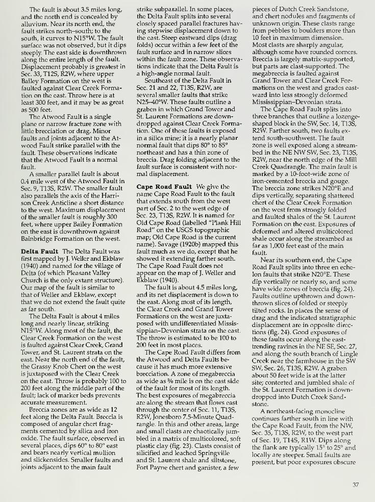
The fault is about 3.5 miles long,
and the north end is concealed byalluvium. Near its north end, the
fault strikes north-south; to the
south, it curves to N15°W. The fault
surface was not observed, but it dips
steeply. The east side is downthrownalong the entire length of the fault.
Displacement probably is greatest in
Sec. 33, T12S, R2W, where upper
Bailey Formation on the west is
faulted against Clear Creek Forma-
tion on the east. Throw here is at
least 300 feet, and it may be as great
as 500 feet.
The Atwood Fault is a single
plane or narrow fracture zone with
little brecciation or drag. Minorfaults and joints adjacent to the At-
wood Fault strike parallel with the
fault. These observations indicate
that the Atwood Fault is a normalfault.
A smaller parallel fault is about
0.4 mile west of the Atwood Fault in
Sec. 9, T13S, R2W. The smaller fault
also parallels the axis of the Harri-
son Creek Anticline a short distance
to the west. Maximum displacement
of the smaller fault is roughly 300
feet, where upper Bailey Formation
on the east is downthrown against
Bainbridge Formation on the west.
Delta Fault The Delta Fault wasfirst mapped by J. Weller and Ekblaw
(1940) and named for the village of
Delta (of which Pleasant Valley
Church is the only extant structure).
Our map of the fault is similar to
that of Weller and Ekblaw, except
that we do not extend the fault quite
as far south.
The Delta Fault is about 4 miles
long and nearly linear, striking
N15°W. Along most of the fault, the
Clear Creek Formation on the west
is faulted against Clear Creek, GrandTower, and St. Laurent strata on the
east. Near the north end of the fault,
the Grassy Knob Chert on the westis juxtaposed with the Clear Creekon the east. Throw is probably 100 to
200 feet along the middle part of the
fault; lack of marker beds prevents
accurate measurement.Breccia zones are as wide as 12
feet along the Delta Fault. Breccia is
composed of angular chert frag-
ments cemented by silica and iron
oxide. The fault surface, observed in
several places, dips 60° to 80° east
and bears nearly vertical mullionand slickensides. Smaller faults andjoints adjacent to the main fault
strike subparallel. In some places,
the Delta Fault splits into several
closely spaced parallel fractures hav-
ing stepwise displacement down to
the east. Steep eastward dips (drag
folds) occur within a few feet of the
fault surface and in narrow slices
within the fault zone. These observa-
tions indicate that the Delta Fault is
a high-angle normal fault.
Southeast of the Delta Fault in
Sec. 21 and 22, T13S, R2W, are
several smaller faults that strike
N25^i0oW. These faults outline a
graben in which Grand Tower andSt. Laurent Formations are down-dropped against Clear Creek Forma-tion. One of these faults is exposed
in a silica mine; it is a nearly planar
normal fault that dips 80° to 85°
northeast and has a thin zone of
breccia. Drag folding adjacent to the
fault surface is consistent with nor-
mal displacement.
Cape Road Fault We give the
name Cape Road Fault to the fault
that extends south from the westpart of Sec. 2 to the west edge of
Sec. 23, T13S, R2W It is named for
Old Cape Road (labelled "Plank Hill
Road" on the USGS topographic
map; Old Cape Road is the current
name). Savage (1920b) mapped this
fault much as we do, except that heshowed it extending farther south.
The Cape Road Fault does not
appear on the map of J. Weller andEkblaw (1940).
The fault is about 4.5 miles long,
and its net displacement is down to
the east. Along most of its length,
the Clear Creek and Grand TowerFormations on the west are juxta-
posed with undifferentiated Missis-
sippian-Devonian strata on the east.
The throw is estimated to be 100 to
200 feet in most places.
The Cape Road Fault differs fromthe Atwood and Delta Faults be-
cause it has much more extensive
brecciation. A zone of megabreccia
as wide as 3/e mile is on the east side
of the fault for most of its length.
The best exposures of megabreccia
are along the stream that flows east
through the center of Sec. 11, T13S,
R2W, Jonesboro 7.5-Minute Quad-rangle. In this and other areas, large
and small clasts are chaotically jum-bled in a matrix of multicolored, soft
plastic clay (fig. 23). Clasts consist of
silicified and leached Springville
and St. Laurent shale and siltstone,
Fort Payne chert and ganister, a few
pieces of Dutch Creek Sandstone,
and chert nodules and fragments of
unknown origin. These clasts rangefrom pebbles to boulders more than
10 feet in maximum dimension.
Most clasts are sharply angular,
although some have rounded corners.
Breccia is largely matrix-supported,
but parts are clast-supported. Themegabreccia is faulted against
Grand Tower and Clear Creek For-
mations on the west and grades east-
ward into less strongly deformedMississippian-Devonian strata.
The Cape Road Fault splits into
three branches that outline a lozenge-
shaped block in the SW, Sec. 14, T13S,
R2W. Farther south, two faults ex-
tend south-southwest. The fault
zone is well exposed along a stream-
bed in the NE NW SW, Sec. 23, T13S,
R2W, near the north edge of the Mill
Creek Quadrangle. The main fault is
marked by a 10-foot-wide zone of
iron-cemented breccia and gouge.The breccia zone strikes N20°E anddips vertically, separating shattered
chert of the Clear Creek Formationon the west from strongly folded
and faulted shales of the St. Laurent
Formation on the east. Exposures of
deformed and altered multicolored
shale occur along the streambed as
far as 1,000 feet east of the mainfault.
Near its southern end, the CapeRoad Fault splits into three en eche-
lon faults that strike N20°E. Thesedip vertically or nearly so, and somehave wide zones of breccia (fig. 24).
Faults outline upthrown and down-thrown slices of folded or steeply
tilted rocks. In places the sense of
drag and the indicated stratigraphic
displacement are in opposite direc-
tions (fig. 24). Good exposures of
these faults occur along the east-
trending ravines in the NE SE, Sec. 27,
and along the south branch of Lingle
Creek near the farmhouse in the SWSW, Sec. 26, T13S, R2W A grabenabout 50 feet wide is at the latter
site; contorted and jumbled shale of
the St. Laurent Formation is down-dropped into Dutch Creek Sand-
stone.
A northeast-facing monoclinecontinues farther south in line withthe Cape Road Fault, from the NW,Sec. 35, T13S, R2W, to the west part
of Sec. 19, T14S, R1W. Dips along
the flank are typically 15° to 25° andlocally are steeper. Small faults are
present, but poor exposures obscure
37

Figure 23 Megabreccia, composed of blocks of altered Springville Shale and St. Laurent Formation in
a soft claylike matrix. This breccia occupies a zone as wide as 3/a mile on the east side of the Cape Road
Fault. Overlying Quaternary alluvium is undeformed. Locality is an east-flowing stream, NW NE SW,Sec. 11, T13S, R2VV, Jonesboro Quadrangle. The staff is 5 feet long.
them. The monocline coincides with
the southern part of the Cape RoadFault as mapped by Savage (1920b).
At its north end, the Cape RoadFault passes under alluvium in the
NW, Sec. 2, T13S, R2W, Jonesboro
7.5-Minute Quadrangle. A possible
continuation is exposed in the bankof Dutch Creek near the center of
the NW, Sec. 35, T12S, R2W Several
faults in this area offset chert of
altered Clear Creek Formation. Thelargest fault has a breccia zone morethan 5 feet wide, which is filled with
large, angular blocks of silicified
Springville Shale, St. Laurent Forma-tion, and probable Fort Payne. Clasts
are as large as several feet across
and float in a matrix of brown plas-
tic clay containing laminae of well
rounded quartz sand. The clasts are
downdropped a minimum of 200
feet. Smaller faults in the bank also
dip vertically or nearly so, and they
contain breccias composed of chert
from the Clear Creek.
The brecciation along the CapeRoad Fault is out of proportion with
the modest vertical displacements.
Breccias are composed of youngerrocks that dropped several hundredfeet downward but underwent little
grinding or crushing, implying that
they collapsed into wide open fis-
sures. Such fissures can develop
under divergent wrench faulting
(Wilcox et al. 1973, Woodcock andFischer 1986). The en echelon pat-
tern of faults near the ends of the
Cape Road Fault is consistent with
right-lateral wrench faulting.
Megabreccias similar to those along
the Cape Road Fault occur in the
Thebes Quadrangle and are inter-
preted as pull-apart grabens along
northeast-trending, right-lateral
faults (Harrison and Schultz 1992).
"Thumb Area"The name "thumb area" refers to an
upland area, shaped like a thumb in
map view. The "thumb area" is
along the Mississippi River bluffs in
Sec. 20 and 29, T12S, R2W (fig. 22)
and has unusual stratigraphy andstructure.
Paleozoic rocks in the thumbrange from upper Clear Creek For-
mation through Springville Shale.
Outliers of Wilcox (?) gravel cap
hills near the "base" (south end) of
the thumb. Several units are thicker
here than in adjacent areas. TheSpringville Shale may exceed 100
feet in the thumb—the thickest
Springville found in the study area.
The New Albany Shale appears to
be about 80 feet thick, whereas it is
absent in outcrops east of the thumb.
The limestone member of the GrandTower Limestone is well developedin the thumb but thin or absent in ex-
posures to the south and east.
Structurally, the thumb is down-dropped. At the base of the thumb,
Paleozoic strata dip 10° to 15° north-
west, away from the Harrison CreekAnticline. Farther north, several
faults that strike east-northeast out-
line grabens and horsts. Either a
fault or a sharp flexure underlies the
northwest-trending valley of DutchCreek northeast of the thumb. Thenearly linear, northeast-trending val-
ley of Green Creek (east of the base
of the thumb) may also contain a
fault. Faults under Green Creek maybe offset continuations of faults that
cross the base of the thumb.Evidently, the thumb area was
deformed repeatedly. Thick GrandTower, New Albany, and Springville
rocks imply Devonian to early Mis-
sissippian downwarping. Sub-
sequently, these strata were folded
and faulted. The Harrison CreekAnticline rose, tilting the base of the
thumb northwest prior to Eocene (?)
time. Wilcox (?) gravel was then de-
posited across the beveled edges of
dipping Paleozoic rocks. Additional,
later downdrop is indicated by the
fact that Wilcox (?) gravel is absent
on nearby higher hills.
Altered AreaThe altered area is a region where all
Paleozoic rocks are leached of carbon-
ate and silicified. It contains impor-
tant commercial silica deposits. Thealtered area is structurally distinct
from surrounding areas, and tecton-
ics evidently played a role in alter-
ing the rocks.
38
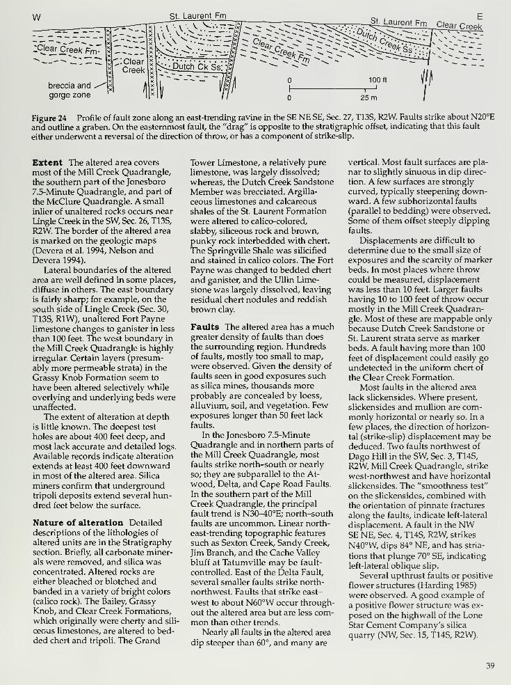
w
iCIear dreek Frrv
breccia and ^gorge zone
XXXXXXXXXXXIxX*>
** — -X 1
C'cTearCreek
!\
St. Laurent Fm
V 'A v> •Sl'-r.-^•vT^1 %^HI£nLFmC(earCreek
v
Dutch Ck
?^Arr,
100 ft
-1
—
25 m
Figure 24 Profile of fault zone along an east-trending ravine in the SE NE SE, Sec. 27, T13S, R2W. Faults strike about N20°E
and outline a graben. On the easternmost fault, the "drag" is opposite to the stratigraphic offset, indicating that this fault
either underwent a reversal of the direction of throw, or has a component of strike-slip.
Extent The altered area covers
most of the Mill Creek Quadrangle,
the southern part of the Jonesboro
7.5-Minute Quadrangle, and part of
the McClure Quadrangle. A small
inlier of unaltered rocks occurs near
Lingle Creek in the SW, Sec. 26, T13S,
R2W. The border of the altered area
is marked on the geologic maps(Devera et al. 1994, Nelson andDevera 1994).
Lateral boundaries of the altered
area are well defined in some places,
diffuse in others. The east boundaryis fairly sharp; for example, on the
south side of Lingle Creek (Sec. 30,
T13S, R1W), unaltered Fort Paynelimestone changes to ganister in less
than 100 feet. The west boundary in
the Mill Creek Quadrangle is highly
irregular. Certain layers (presum-
ably more permeable strata) in the
Grassy Knob Formation seem to
have been altered selectively while
overlying and underlying beds wereunaffected.
The extent of alteration at depth
is little known. The deepest test
holes are about 400 feet deep, andmost lack accurate and detailed logs.
Available records indicate alteration
extends at least 400 feet downwardin most of the altered area. Silica
miners confirm that undergroundrripoli deposits extend several hun-dred feet below the surface.
Nature of alteration Detailed
descriptions of the lithologies of
altered units are in the Stratigraphy
section. Briefly, all carbonate miner-
als were removed, and silica wasconcentrated. Altered rocks are
either bleached or blotched andbanded in a variety of bright colors
(calico rock). The Bailey, GrassyKnob, and Clear Creek Formations,
which originally were cherty and sili-
ceous limestones, are altered to bed-
ded chert and rripoli. The Grand
Tower Limestone, a relatively pure
limestone, was largely dissolved;
whereas, the Dutch Creek Sandstone
Member was brecciated. Argilla-
ceous limestones and calcareous
shales of the St. Laurent Formation
were altered to calico-colored,
slabby, siliceous rock and brown,
punky rock interbedded with chert.
The Springville Shale was silicified
and stained in calico colors. The Fort
Payne was changed to bedded chert
and ganister, and the Ullin Lime-
stone was largely dissolved, leaving
residual chert nodules and reddish
brown clay.
Faults The altered area has a muchgreater density of faults than does
the surrounding region. Hundredsof faults, mostly too small to map,were observed. Given the density of
faults seen in good exposures such
as silica mines, thousands moreprobably are concealed by loess,
alluvium, soil, and vegetation. Fewexposures longer than 50 feet lack
faults.
In the Jonesboro 7.5-Minute
Quadrangle and in northern parts of
the Mill Creek Quadrangle, mostfaults strike north-south or nearly
so; they are subparallel to the At-
wood, Delta, and Cape Road Faults.
In the southern part of the Mill
Creek Quadrangle, the principal
fault trend is N30^0°E; north-south
faults are uncommon. Linear north-
east-trending topographic features
such as Sexton Creek, Sandy Creek,
Jim Branch, and the Cache Valley
bluff at Tatumville may be fault-
controlled. East of the Delta Fault,
several smaller faults strike north-
northwest. Faults that strike east-
west to about N60°W occur through-
out the altered area but are less com-mon than other trends.
Nearly all faults in the altered area
dip steeper than 60°, and many are
vertical. Most fault surfaces are pla-
nar to slightly sinuous in dip direc-
tion. A few surfaces are strongly
curved, typically steepening down-ward. A few subhorizontal faults
(parallel to bedding) were observed.
Some of them offset steeply dipping
faults.
Displacements are difficult to
determine due to the small size of
exposures and the scarcity of markerbeds. In most places where throw
could be measured, displacement
was less than 10 feet. Larger faults
having 10 to 100 feet of throw occur
mostly in the Mill Creek Quadran-gle. Most of these are mappable only
because Dutch Creek Sandstone or
St. Laurent strata serve as markerbeds. A fault having more than 100
feet of displacement could easily goundetected in the uniform chert of
the Clear Creek Formation.
Most faults in the altered area
lack slickensides. Where present,
slickensides and mullion are com-monly horizontal or nearly so. In a
few places, the direction of horizon-
tal (strike-slip) displacement may be
deduced. Two faults northwest of
Dago Hill in the SW, Sec. 3, T14S,
R2W, Mill Creek Quadrangle, strike
west-northwest and have horizontal
slickensides. The "smoothness test"
on the slickensides, combined with
the orientation of pinnate fractures
along the faults, indicate left-lateral
displacement. A fault in the NWSE NE, Sec. 4, T14S, R2W, strikes
N40°W, dips 84° NE, and has stria-
tions that plunge 70° SE, indicating
left-lateral oblique slip.
Several upthrust faults or positive
flower structures (Harding 1985)
were observed. A good example of
a positive flower structure was ex-
posed on the highwall of the LoneStar Cement Company's silica
quarry (NW, Sec. 15, T14S, R2W).
39

Several curving high-angle reverse
faults steepen downward and con-
verge to a single vertical fault (fig. 25).
Another flower structure was ob-
served in the bank of Lingle Creek(NW NE, Sec. 26, T13S, R2W). Asmall reverse fault and a small, tight
reverse kink fold both strike N80-85°E and dip steeply north (fig. 26).
Other compressional structures in-
clude a monoclinal kink fold near
the portal of an abandoned silica
mine (SE NW NW, Sec. 14, T14S,
R2W). The axial plane of the kink
fold trends N70°W/70°SW. Nearly
all of the reverse faults in the altered
area dip at least 60°.
What may be a large positive
flower structure was mapped in the
NE, Sec. 33, and an adjacent part of
Sec. 34, T13S, R2W. A narrow block
of Bailey Limestone and Bainbridge
Formation is faulted against Bailey
and Grassy Knob on both sides. Bor-
dering faults strike west-northwest,
parallel to nearby faults that havehorizontal slickensides.
Pull-apart structures, or negative
flower structures, may be more com-mon than positive flower structures.
Many fault zones in the altered area
are filled with coarse breccia of angu-lar chert fragments and, less com-monly, Cretaceous-Tertiary gravel
(fig. 27). Some faults that have only
a few inches or feet of vertical sepa-
ration contain breccia zones several
feet wide. For example, a northeast-
trending fault at the head of Sexton
Creek (near the SE corner, Sec. 4,
T14S, R2W, Mill Creek Quadrangle)has a breccia zone 30 feet wide but
no detectable vertical offset. Breccia
zones occurring along vertical faults
typically are funnel-shaped, narrow-
ing downward. Breccias also occur
at the crests of small chevron anti-
clines (fig. 28). J. Weller (1940, un-
published field notes, ISGS openfiles) reported vertical fractures
filled with gravel (Tuscaloosa?) in
the roof of a ganister mine (nowabandoned) northeast of Elco in the
NE NE NW, Sec. 18, T14S, R1W.A large pull-apart structure is pres-
ent in You-Be-Damned Hollow in
the SW NW, Sec. 35, T13S, R2W. Thefault zone, which appears to strike
north-south, contains a megabreccia
zone nearly 100 feet wide. Blocks
and fragments of limestone, silt-
stone, and shale from the DevonianSt. Laurent Formation and Mississip-
pian Springville Shale are down-
-£^Lr^*-
Figure 25 Faults on the north-facing wall of Lone Star Cement Company'sopen-pit silica mine in the NE NW, Sec. 15, T14S, R2W, Mill Creek Quadrangle.
On the east (left) is a positive flower structure composed of several upthrust
faults that steepen downward and combine into a single vertical fault. Note that
the beds do not match on opposite sides of this structure. The hard brown chert
layer "A" traces across with little vertical offset, but chert layer "B" is not present
east of the fault. This is further evidence for strike-slip displacement. The nearly
vertical fault west of the flower structure has a sinuous fault surface, indicative
of strike-slip. The rock is altered Clear Creek Formation (interbedded chert andtripoli). The strike trend of faults could not be determined. The staff is 5 feet long.
dropped against Dutch Creek Sand-
stone. Clasts are as much as several
feet across, and some are internally
deformed (fig. 29). Bedding of DutchCreek Sandstone west of the fault
zone and St. Laurent Formation east
of the zone both dip gently east.
Springville clasts in the breccia are
downdropped at least 100 feet rela-
tive to adjacent strata. This breccia is
similar to that found along the CapeRoad Fault.
Normal and reverse faults com-monly occur parallel and side-by-
side. For example, in the Lone Star
Cement Company's silica mine, twonormal faults and one reverse fault
all strike N40-45°E. Normal and re-
verse faults strike both north-south
and east-west at the Jason no. 2
open-pit silica mine in the SE, Sec. 22,
T13S, R2W. Moreover, drag along
many faults indicates movementopposite to the observed stratigraphic
(vertical) displacement. Bedding onboth sides of a fault may be folded
in the same direction (upward or
downward), or bedding may be
40

Figure 26 Sketch of fault and kink fold exposed in
the bank of the creek, 300 feet from the north line, 2,000
feet from the east line, Sec. 26, T13S, R2W. Both the reverse fault and the axial
plane of the kink fold strike N80-85°W and dip steeply north. These structures
are more likely products of strike-slip faulting than of horizontal compression.
NW
Figure 27 Sketch of a fault in the southwest bank of Johnson Creek, just east ofthe NW corner, Sec. 24, T14S, R2W. Fault strikes north-northeast and dips verti-
cally; chert and tripoli of Clear Creek Formation apparently are downthrown to
the southeast. The fault zone is filled with a loose breccia of angular chert frag-
ments intermixed with silt and clay, some of which is laminated, indicating deposi-tion by water in large open crevices. The sinuous fault surface, wide breccia zone,and inconsistent "drag" folds indicate a component of strike-slip.
nearly horizontal on one side of a
fault and steeply tilted on the other
(fig- 30).
Folds Folds in the altered area are
predominantly brittle. Most folds are
chevron or hinge-shaped (fig. 28).
Flanking dips greater than 30° are
uncommon except adjacent to faults.
Small monoclines, anticlines, andsynclines have vertical or steeply
dipping axial planes, along whichrocks are intensively fractured. Suchfolds pass laterally or vertically into
faults of small displacement. Distin-
guishing sharp hinge-like folds fromfaults can be difficult when there are
no marker beds (as is usually the
case).
Small arcuate folds and kinkfolds are associated with flower struc-
tures. Most such folds trend east-
west to east-southeast-west-north-
west. These folds are closely associ-
ated with faults. They may be fault-
propagation folds.
Bedding of the Clear Creek For-
mation in the altered area gently
undulates in seemingly randommanner (fig. 6). Undulations may bepartly tectonic structures and partly
products of uneven settling duringalteration.
Joints and clastic dikes Joint-
ing is pervasive in all hard rocks of
the altered area. Only soft tripoli
and claylike shales do not display
joints. Most large outcrops display
two to four sets of joints. North-south joints are abundant andclosely spaced throughout the
altered area. Joints that trend north-
northeast are abundant in someareas and uncommon in others.
East-west joints occur throughoutthe altered area but rarely are closer
than 1 foot apart. Joints that trend
west-northwest are common, butthey are widely spaced also. Thus,the trends and abundances of joints
are closely similar to those of faults
in the altered area.
Narrow veins and dikes filled
with clay, silt, sand, gravel, andchert fragments are widespread in
the altered area. Trends vary, butmany strike east-west to west-north-
west-east-southeast and are vertical
or nearly so. Most clastic dikes are
slightly sinuous in strike and dip.
Clay-filled veins and dikes are mostcommon in the Clear Creek Forma-tion but occur in other units, includ-
ing Cretaceous-Tertiary sands and
41
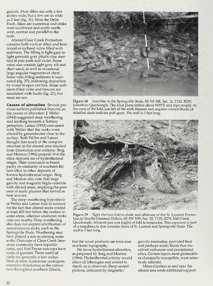
gravels. Most dikes are only a fewinches wide, but a few are as wideas 2 feet (fig. 31). Near the Delta
Fault, dikes are numerous and strike
west-southwest and north-north-
west, normal and parallel to the
fault.
Altered Clear Creek Formationcontains both vertical dikes and hori-
zontal or inclined veins filled with
sediment. The filling is light gray to
light greenish gray plastic clay, mot-tled in pale pink and violet. Someveins also contain light gray silt andchert sand, as well as occasional
large angular fragments of chert.
Some vein-filling sediment is lami-
nated (fig. 27), indicating deposition
by water in open cavities. Some sedi-
ment-filled veins and fissures are
associated with faults (fig. 27), but
most are not.
Causes of alteration Several pre-
vious authors published theories onthe causes of alteration. J. Weller
(1944) suggested deep weathering
and leaching beneath a Tertiary
peneplain. Lamar (1953) concurred
with Weller that the rocks werealtered by groundwater close to the
surface. Both Weller and Lamarthought that much of the complexstructure in the altered area resulted
from dissolution and collapse. Berg
and Masters (1994) propose that the
silica deposits are of hydrothermalorigin. Their conclusion is based
partly on similarity of southern Illi-
nois silica to other deposits of
known hydrothermal origin. Berg
and Masters also note that large
gravity and magnetic highs coincide
with altered areas, implying the pres-
ence of mafic plutons that served as
heat sources.
The deep-weathering hypothesis
of Weller and Lamar fails to account
for the fact that altered rocks extend
at least 400 feet below the surface in
some areas, whereas unaltered rocks
crop out nearby. Deep weathering
also does not explain silicification of
noncalcareous rocks, such as the
Springville Shale. Weathering mayhave played a role in altering somerocks. Outcrops of Clear Creek lime-
stone commonly have tripolitic
rinds, and Fort Payne outcrops haverinds of ganister. These surficial
rinds are generally a few inches
thick at most. Limestone undergoesextensive dissolution in the subsur-face throughout southern Illinois,
Figure 28 Anticline in the Springville Shale, SE NE NE, Sec. 11, T13S, R2W,Jonesboro Quadrangle. The axial plane strikes about N30°E and dips steeply. Atthe crest of the fold, just left of the staff, fissures and angular rotated blocks of
silirified shale indicate pull apart. The staff is 5 feet long.
Figure 29 Tight chevron fold in shale and siltstone of the St. Laurent Forma-tion in You-Be-Damned Hollow, SE SW NW, Sec. 35, TBS, R2W, Mill CreekQuadrangle. Siltstone just east (right) of fold is horizontal. This exposure is part
of a megabreccia that contains clasts of St. Laurent and Springville Shale. Thestaff is 5 feet long.
but the usual products are terra rosa
and karst topography.
We favor hydrothermal alteration,
as proposed by Berg and Masters
(1994). Hydrothermal activity wouldaffect all lithologies and extend to
depth, as is observed. Deep-seated
plutons, indicated by magnetic/
gravity anomalies, provided heat
and perhaps acidic fluids that dis-
solved carbonate and precipitated
silica. Certain layers, more permeable
or chemically susceptible, were selec-
tively affected.
Mineralization in and near the
altered area lends additional support
42

--••>"*
r.*
Figure 30 Fault in the Springville Shale, SW SE SE, Sec. 11, T13S, R2W, Jones-
boro Quadrangle, strikes N20°E and the west (left) side is downthrown. Note the
steep dip of the downthrown block contrasting with near-horizontal shale in the
upthrown block.
Figure 31 Fissure (2 ft wide) in Clear Creek Formationis filled with breccia of angular chert clasts and strikes
N38°E. It is located just west of the Delta Fault.
to the hydrothermal theory. Limo-nite, goethite, and botryoidal manga-nese oxides are common in the
altered area, particularly along
faults. The characteristic rose andmagenta shades of calico rock are
probably due to manganese. Iron
and manganese oxides are commonin low-temperature hydrothermaldeposits, although they also occur in
non-hydrothermal settings. Fluorite
occurs in veins and cavities in the
Ste. Genevieve Limestone at the
Anna Quarry, a short distance north
of the altered area. Cuttings from the
Humble Oil Company no. 1 Pickel
well, drilled just west of the altered
area, contained unusually high con-
centrations of silver, arsenic, lead,
molybdenum, and copper. Total me-tallic content of samples from the
Pickel well was the highest among29 wells sampled around the west-
ern and southern margins of Illinois
(Erickson et al. 1987).
Our mapping reveals that bed-
rock is intensively faulted and frac-
tured throughout the altered area.
Faults and joints trend in several
directions, forming an intersecting
gridwork. The density of faults in
the altered area contrasts with the
virtual absence of faults in the bor-
dering eastern and western homo-clinal areas. Faults and fractures
provide pathways for hydrothermal
fluids. In particular, open fissures
and pull-apart structures, commonthroughout the altered area, are
highly permeable. Some of the mostintensive silicification (e.g., near Elco
and in the central Mill Creek Quad-rangle) occurs along mapped faults.
Clastic dikes may be extensional or
transtensional fissures that werefilled with sediment carried by circu-
lating fluid.
In conclusion, low-temperature
hydrothermal action was the pri-
mary cause of altered rock in the
study area. Deep-seated plutons sup-
plied the heat. The fluids may havecome from the plutons or fromgroundwater, circulated by convec-
tion. Intersecting sets of closely
spaced, extensional and transten-
sional faults and fractures provided
pathways for the hot water. An am-ple supply of fine grained biogenic
and detrital silica lay in the Bailey,
Grassy Knob, Clear Creek, Fort
Payne, and other formations. Acidic
hydrothermal fluids removed car-
bonate minerals and replaced them
43
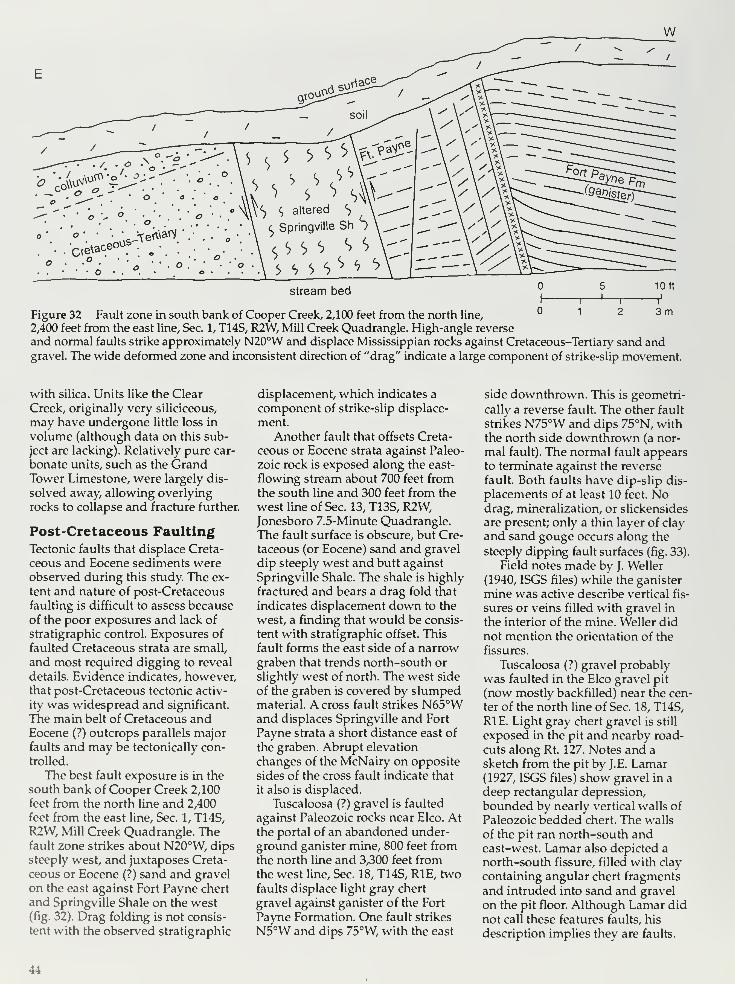
Figure 32 Fault zone in south bank of Cooper Creek, 2,100 feet from the north line,
2,400 feet from the east line, Sec. 1, T14S, R2W, Mill Creek Quadrangle. High-angle reverse
and normal faults strike approximately N20°W and displace Mississippian rocks against Cretaceous-Tertiary sand andgravel. The wide deformed zone and inconsistent direction of "drag" indicate a large component of strike-slip movement.
with silica. Units like the Clear
Creek, originally very siliciceous,
may have undergone little loss in
volume (although data on this sub-
ject are lacking). Relatively pure car-
bonate units, such as the GrandTower Limestone, were largely dis-
solved away, allowing overlying
rocks to collapse and fracture further.
Post-Cretaceous Faulting
Tectonic faults that displace Creta-
ceous and Eocene sediments wereobserved during this study. The ex-
tent and nature of post-Cretaceous
faulting is difficult to assess because
of the poor exposures and lack of
stratigraphic control. Exposures of
faulted Cretaceous strata are small,
and most required digging to reveal
details. Evidence indicates, however,that post-Cretaceous tectonic activ-
ity was widespread and significant.
The main belt of Cretaceous andEocene (?) outcrops parallels majorfaults and may be tectonically con-
trolled.
The best fault exposure is in the
south bank of Cooper Creek 2,100
feet from the north line and 2,400
feet from the east line, Sec. 1, T14S,
R2W, Mill Creek Quadrangle. Thefault zone strikes about N20°W, dips
steeply west, and juxtaposes Creta-
ceous or Eocene (?) sand and gravel
on the east against Fort Payne chert
and Springville Shale on the west(fig. 32). Drag folding is not consis-
tent with the observed stratigraphic
displacement, which indicates a
component of strike-slip displace-
ment.
Another fault that offsets Creta-
ceous or Eocene strata against Paleo-
zoic rock is exposed along the east-
flowing stream about 700 feet fromthe south line and 300 feet from the
west line of Sec. 13, T13S, R2W,Jonesboro 7.5-Minute Quadrangle.
The fault surface is obscure, but Cre-
taceous (or Eocene) sand and gravel
dip steeply west and butt against
Springville Shale. The shale is highly
fractured and bears a drag fold that
indicates displacement down to the
west, a finding that would be consis-
tent with stratigraphic offset. This
fault forms the east side of a narrowgraben that trends north-south or
slightly west of north. The west side
of the graben is covered by slumpedmaterial. A cross fault strikes N65°Wand displaces Springville and Fort
Payne strata a short distance east of
the graben. Abrupt elevation
changes of the McNairy on opposite
sides of the cross fault indicate that
it also is displaced.
Tuscaloosa (?) gravel is faulted
against Paleozoic rocks near Elco. Atthe portal of an abandoned under-
ground ganister mine, 800 feet fromthe north line and 3,300 feet from
the west line, Sec. 18, T14S, R1E, twofaults displace light gray chert
gravel against ganister of the Fort
Payne Formation. One fault strikes
N5°W and dips 75°W, with the east
side downthrown. This is geometri-
cally a reverse fault. The other fault
strikes N75°W and dips 75°N, withthe north side downthrown (a nor-
mal fault). The normal fault appearsto terminate against the reverse
fault. Both faults have dip-slip dis-
placements of at least 10 feet. Nodrag, mineralization, or slickensides
are present; only a thin layer of clay
and sand gouge occurs along the
steeply dipping fault surfaces (fig. 33).
Field notes made by J. Weller
(1940, ISGS files) while the ganister
mine was active describe vertical fis-
sures or veins filled with gravel in
the interior of the mine. Weller did
not mention the orientation of the
fissures.
Tuscaloosa (?) gravel probablywas faulted in the Elco gravel pit
(now mostly backfilled) near the cen-
ter of the north line of Sec. 18, T14S,
R1E. Light gray chert gravel is still
exposed in the pit and nearby road-
cuts along Rt. 127. Notes and a
sketch from the pit by J.E. Lamar(1927, ISGS files) show gravel in a
deep rectangular depression,
bounded by nearly vertical walls of
Paleozoic bedded chert. The walls
of the pit ran north-south andeast-west. Lamar also depicted a
north-south fissure, filled with clay
containing angular chert fragments
and intruded into sand and gravel
on the pit floor. Although Lamar did
not call these features faults, his
description implies they are faults.
44
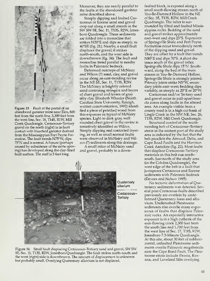
I
Figure 33 Fault at the portal of anabandoned ganister mine near Elco, 800
feet from the north line, 3,300 feet from
the west line, Sec. 18, T14S, R1W, Mill
Creek Quadrangle. Cretaceous-Tertiary
gravel on the north (right) is in fault
contact with bleached ganister derived
from the Mississippian Fort Payne For-
mation. The fault trends N75°W, dips
75°N and is normal. A fissure (perhaps
caused by subsidence of the mine open-
ing) has developed along the clay-lined
fault surface. The staff is 5 feet long.
Moreover, they are nearly parallel to
the faults at the abandoned ganister
mine described above.
Steeply dipping and faulted Cre-
taceous or Eocene sand and gravel
crop out along a small stream in the
SW SW SE, Sec. 11, T13S, R2W, Jones-
boro Quadrangle. These sediments
are folded into a monocline that
strikes N20°E and dips as steeply as
40°SE (fig. 21). Nearby, a small fault
displaces the gravel; it strikes
north-south, and the west side is
downthrown (fig. 34). The fault and
monocline trend parallel to nearby
faults in Paleozoic bedrock.
Deformed outcrops of McNairyand Wilcox (?) sand, clay, and gravel
occur along an east-trending ravine
in the NE SE, Sec. 11, T13S, R2W.The McNairy is brightly colored
sand containing stringers and layers
of chert gravel and lenses of gray
silty clay. Elisabeth Wheeler (North
Carolina State University, Raleigh,
written communication, 1992) identi-
fied a piece of petrified wood from
this exposure as typical of McNairyspecies. Light to dark gray, well
rounded chert gravel in the ravine is
tentatively identified as Wilcox.
Steeply dipping and contorted layer-
ing, as well as small normal faults
were observed in McNairy and Wil-
cox (?) sediments along this drainage.
A small inlier of McNairy sand
and gravel, probably in a down-
Figure 34 Small fault displacing Cretaceous-Tertiary sand and gravel, SW SWSE, Sec. 11, T13S, R2W, Jonesboro Quadrangle. The fault strikes north-south andthe west (right) side is downthrown. The amount of displacement is unknownbut probably small. Overlying Quaternary alluvium is not displaced.
faulted block, is exposed along a
small south-flowing stream north of
You-Be-Damned Hollow in the NEof Sec. 35, T13S, R2W, Mill CreekQuadrangle. The inlier is sur-
rounded by tilted and faulted Missis-
sippian rocks. Bedding of the sandand gravel strikes approximately
east-west and dips 25°S. Exposures
of Springville Shale and Fort PayneFormation occur immediately north
of the dipping sand and gravel.
They are offset by a fault that trends
N80°E and dips 70°S. A short dis-
tance south of the gravel inlier,
Springville Shale dips 15°N. South-
ward, along the bed of the mainstream in You-Be-Damned Hollow,
Springville Shale is strongly jointed.
Primary joints strike N5°W, secon-
dary joints east-west; bedding dips
variably, as steeply as 20°E or 20°W.
Cretaceous and/or Tertiary sand
and gravel occur in pull-apart brec-
cia zones along faults in the altered
area. An example visible from a
county road is in a high cut bank of
Lingle Creek in the NW NE, Sec. 26,
T13S, R2W, Mill Creek Quadrangle.
Structural control of the south-
trending belt of Cretaceous-Tertiary
strata in the eastern part of the study
area is indicated by the fact that the
belt parallels the Atwood, Delta, andCape Road Faults and the Harrison
Creek Anticline (fig. 22). Most faults
that displace Cretaceous-Tertiary
materials in this belt run north-
south. Just north of the study area
(in the Cobden Quadrangle), the
west edge of the belt is a fault that
juxtaposes Cretaceous and Eocenesediments with Paleozoic bedrock
(Devera and Nelson 1995).
No tectonic deformation of Qua-ternary sediments was detected. Sev-
eral post-Cretaceous faults described
previously are overlain by unde-formed Quaternary loess and allu-
vium. Undisturbed Pleistocene
sediments also overlie many expo-sures of faults that displace Paleo-
zoic rocks. An especially instructive
exposure is in a high cutbank of the
east-flowing creek 2,300 feet fromthe south line and 1,700 feet fromthe west line of Sec. 17, T11S, R2W,Jonesboro 7.5-Minute Quadrangle.
At this site, about 30 feet of subhori-
zontal, unfaulted Pleistocene sedi-
ments overlie Paleozoic megabreccia
near the Cape Road Fault. The Pleis-
tocene strata include Peoria, Rox-
ana, and Loveland Silts overlying
45

two distinct layers of pre-Loveland
alluvium (Leon R. Follmer, personal
communication, 1993).
To summarize, faults that dis-
place Cretaceous-Tertiary sediments
in the Mill Creek and Jonesboro
Quadrangles strike approximately
north-south and east-west, andthey dip steeply, nearly vertical in
most cases. Vertical displacements
probably range from a few tens of
feet to 100 feet or more. Some faults,
particularly the north-south ones,
probably have large components of
strike-slip displacement. No evi-
dence of Quaternary tectonic activ-
ity was discovered.
SummaryThe Jonesboro Quadrangle clearly
has a complex tectonic history, andthe order of events and their role in
regional geology remain unclear.
Mapping in adjacent areas may fur-
ther clarify the relationships.
Gentle eastward dips in the east-
ern and western homoclinal areas
reflect subsidence of the Illinois
Basin relative to the Ozark Dome.This subsidence took place during
and after the Paleozoic Era.
The Harrison Creek Anticline is
similar in trend and geometry to the
Du Quoin Monocline and the Salemand Louden Anticlines farther north
in Illinois. Like them, it probably
overlies faults in crystalline base-
ment (Nelson 1991). The Du Quoin,
Salem, and Louden structures devel-
oped principally in the late Missis-
sippian and Pennsylvanian Periods,
with additional post-Pennsylvanian
uplift (Kolata and Nelson 1991).
The Atwood and Delta Faults are
post-Devonian, high-angle normalfaults. Northeast of the study area,
similar normal faults strike north-
northwest in the Makanda (Jacobson
and Weibel 1993) and Bloomfield
(Nelson 1993) Quadrangles. Thesefaults displace rocks as young as
Morrowan (Lower Pennsylvanian)
and presumably are products of hori-
zontal extension.
The Cape Road Fault parallels the
Atwood and Delta Faults but exhib-
its extensive brecciation and fracture
patterns that indicate dextral strike-
slip. No other large fault in the area
has similar features. Small, parallel
faults east of the Cape Road displace
Cretaceous and Eocene (?) strata.
Possibly, the Cape Road Fault origi-
nated as a normal fault, along with
the Atwood and Delta Faults, andlater was reactivated under a differ-
ent stress field as a strike-slip fault.
Altered (leached and silicified)
rocks in the study area are shattered
by three or four intersecting sets of
faults and joints. This fracture sys-
tem provided pathways for hy-
drothermal fluids that were heated
by deep-seated plutons. The nearest
outcropping igneous rocks, in the
Fluorspar District to the east, are
Early Permian (Zartman et al. 1967).
More likely, the Jonesboro hydrother-
mal event is related to Late Creta-
ceous-early Tertiary igneous activity
in the Mississippi Embayment. Theinferred pluton in the Jonesboro
Quadrangle is in line with a series of
known and inferred mafic plutons
along the west edge of the Embay-ment in Arkansas and Missouri. All
of these plutons exhibit high gravity
and magnetic values (Hildenbrand
1984). The Little Rock (Arkansas)
pluton crops out and is composed of
nepheline syenite of Late Cretaceous
age (Moody 1949). Northeast of the
Little Rock pluton is the Newportpluton, interpreted to be UpperCretaceous or Paleocene. Associated
with the Newport pluton are manga-nese deposits and silicified Paleo-
cene limestone (Glick 1982).
Many faults in the altered area
probably are strike-slip. Some are
compressional, but transtensional
faults that produced pull-apart struc-
tures are more common. The domi-nant trends are north-south, east-
west, and northeast-southwest. In
the adjacent Thebes Quadranglemany northeast-striking faults
exhibit right-lateral strike-slip andoutline pull-apart structures. Units
as young as the Mounds Gravel
(Pliocene ?) are displaced in the
Thebes Quadrangle (Harrison andSchultz 1992, Nelson and Harrison
1993). Major northwest-trending
faults on the Ozark Dome were inter-
preted as left-lateral transfer faults
by Clendenin et al. (1989).
46

GEOLOGIC HISTORY
In this section, we interpret deposi-
tional and tectonic events in the
study area. A comprehensive treat-
ment is not attempted; emphasis is
given to new findings on Devonian,
Mississippian, and Cretaceous-Tertiary sedimentation and tectonic
activity.
OrdovicianPre-Maquoketa strata will not be dis-
cussed here because information is
limited. For a regional review, see
Kolata and Noger (1991).
A rapid marine transgression
began the deposition of the Maquo-keta; the Cape La Croix Member wasdeposited in relatively deep water.
Gradual shoaling is reflected in the
upward increasing silt content,
gradational to the Thebes Sandstone
Member. Part of the Ozark Dome in
southeast Missouri was exposedsubaerially and supplied sediment
to the Thebes Member. During depo-sition of the Thebes, the sea gradu-
ally became shallower; finally, the
sea floor was exposed in the tidal
flats represented by the red andgreen mudstone at the top of the
Thebes.
The Orchard Creek-Girardeaurepresents another sequence of
rapid transgression (dark clay
shales) followed by gradual shoaling
(increasing limestone content up-
ward). These strata closely resemble
the Fayetteville Shale (Mississip-
pian) of Arkansas, which likewise
represents an upward-shoaling
sequence (Handford 1986). Lime-
stones of the Orchard Creek-Girar-
deau are confined to the flanks of
the Ozark Dome and do not extend
into the more rapidly subsiding Illi-
nois Basin to the east.
After regression and erosion
came deposition of shallow, subtidal
sediments of the Leemon Formation,
which were then largely removed byanother cycle of erosion, bringing
Ordovician history to a close.
Silurian
Silurian depositional conditions in
southwestern Illinois are poorly
defined and have received little
attention in the literature. Accordingto Whitaker (1988), the study area
lay on a shallow, east-sloping rampbetween land on the Ozark Domeand deeper water in the southern
part of the Illinois Basin. The region
seems to have been stable techni-
cally, and sedimentation proceededunder low energy conditions. There
is little evidence relevant to esti-
mating water depth.
Beginning in mid-Niagaran(Moccasin Springs) time, increasing
amounts of fine terrigenous elastics
were deposited in the study area.
Although the source of these elastics
is not known, they are widespreadin southeastern Missouri and south-
ern Illinois. Sedimentation appar-
ently continued without a break into
the Bailey Limestone and across the
Silurian-Devonian boundary.
DevonianTerrigenous clastic input waned as
Bailey deposition proceeded, but
sponges and other organisms pro-
duced large amounts of silica. Thefine grain size and thin, even layer-
ing of the Bailey imply low energy
but not necessary deep water sedi-
mentation. Banaee (1981), however,
interpreted the Bailey as comprising
carbonate turbidites laid down in a
relatively deep basin.
The heavily silicified, unfossilifer-
ous Grassy Knob Chert is an enig-
matic unit. Although the unit is
partly carbonate rock outside of the
altered area, bedded chert persists
into the deep subsurface. This indi-
cates that part of the Grassy Knob is
primary silica. The lithologically
similar and partly coeval ArkansasNovaculite and Caballos Novaculite
continue to engender controversy
after more than 100 years of study.
These novaculites have beenassigned to settings that range fromintertidal to abyssal (McBride and
Folk 1977). We tentatively favor rela-
tively deep water (below wave base,
and deeper than either Bailey or
Clear Creek) for the Grassy Knob.
Evidence includes the sparse fauna
and presence of horizontal burrowsrather than vertical (escape) burrows.
The Clear Creek Formation wasdeposited as primary carbonate mudwith a large dose of biogenic silica
from sponges and radiolaria (Allen
1985). Common fossils and vertical
(escape) burrows indicate fairly
rapid sedimentation albeit underlow energy conditions. Water depthprobably diminished toward the endof Clear Creek time. Upward, brachio-
pods become more numerous, andterrigenous silt and fine sand camein possibly from the Ozark Dome. Amajor drop in sea level near the endof Early Devonian time resulted in
widespread unconformity on the
flanks of the dome.The eastern Ozark Dome was
uplifted recurrently from MiddleDevonian on into Mississippian
time; this strongly influenced thick-
ness and facies patterns in the study
area. Although direct evidence is
lacking, basement faults may havebeen reactivated during this time
period. The "thumb area" in the
western Jonesboro 7.5-Minute Quad-rangle remained persistently lowwhile adjacent parts of the OzarkDome rose.
During the Eifelian transgression,
quartz sand from the St. Peter andolder sandstones exposed on the
Ozark Dome was reworked into the
shoreline deposits that later becamethe Dutch Creek Sandstone Member.This was followed by deposition of
clean skeletal carbonate (upper mem-ber of the Grand Tower) in shallow
subtidal settings. Tectonic action
ushered in the Givetian Age; the
crustal block north of the Ste. Gene-
vieve Fault Zone rose (S. Weller andSt. Clair 1928, Nelson and Lumm1985), along with parts of the eastern
Ozark Dome. Fine terrigenous elas-
tics from these sources intertongued
47

with shallow water carbonates of
the St. Laurent Formation.
Another drop of sea level in late
Givetian or early Frasnian time
occurred, and the St. Laurent strata
were eroded. Transgression first
brought basal sand (Sylamore Bed)
and then the main body of the NewAlbany Shale. The latter was laid
down in still water under anoxic,
reducing conditions (Cluff et al.
1981). The Ozark Dome, except for
the "thumb area," continued to rise
during New Albany sedimentation.
Near the end of the Devonian Period,
sea level dropped and the top of the
New Albany was beveled in the
study area.
Mississippian
The feather-edge of the ChouteauLimestone reached the northern part
of the study area during the Kinder-
hookian Age. This transgressive lime-
stone contains rip-up clasts from the
New Albany. The Chouteau was suc-
ceeded disconformably (?) by the
Springville Shale (lower Valmey-eran), which was a distal, prograd-
ing clastic wedge of the Bordendelta (Lineback 1966). In the techni-
cally positive southwestern part of
the study area, the Springville over-
stepped the New Albany onto the
underlying St. Laurent Formation.
After another relative fall and rise
of sea level, siliceous carbonates
(Fort Payne) accumulated on the
eroded surface of the Springville.
Fine grain size, sparse fauna, thin
even layering, and lack of high en-
ergy sedimentary structures indicate
relatively deep water (below wavebase) for the Fort Payne. The source
of silica in the Fort Payne has not
been addressed. Possible terrigenous
sources include the Borden delta
(contrary to Lineback 1966, the Bor-
den and Fort Payne may be coeval)
and the Ouachita trough. Biogenic
silica may also be involved. Thegradual, intertonguing change fromdark, fine grained, siliceous sedi-
ments of the Fort Payne to light,
coarse, crossbedded sediments of
the Ullin Limestone reflects shoaling
into high energy settings above nor-
mal wave base. The prevalent cross-
bedding of the Ullin is not in accordwith Lineback's (1966) hypothesis
that the Ullin is a deep water de-
posit filling in a "starved basin."
The Salem, St. Louis, and Ste.
Genevieve Limestones represent a
variety of predominantly shallow
subtidal, carbonate-shelf deposi-
tional settings. Crossbedded oolitic
and crinoidal grainstones alternate
and intertongue with cherty lime
mudstones and wackestones. Theserepresent offshore bars, and lagoons
protected by bars, respectively
(Cluff and Lineback 1981). In the
study area, Paleozoic sedimentary
history drew to a close with the in-
flux of terrigenous elastics (Pope
Group) from a source area north-
west of the region.
Late Mississippian throughEarly CretaceousNo sedimentary record remains in
the study area of early Chesterian
through Late Cretaceous time
although many structural features
probably developed during this long
episode. Widespread folding andfaulting in adjacent areas reflect the
compressional Alleghenian andOuachita orogenies and later conti-
nental rifting (Kolata and Nelson1991).
The Harrison Creek Anticline is
probably a late Paleozoic structure.
Devonian rocks are folded, but Cre-
taceous-Tertiary strata on the north-
west flank, near the base of the
"thumb," rest unconformably onvarious Paleozoic units at nearly the
same elevation. Hence, the anticline
probably is pre-Cretaceous. The Har-
rison Creek is similar in trend andstructural style to anticlines in the
central part of the Illinois Basin,
which underwent uplift from late
Mississippian through Pennsylva-
nian time. A similar age for the Har-
rison Creek Anticline is indicated.
The Atwood and Delta Faults andsmaller, parallel faults are high-
angle normal faults nearly parallel
with the Harrison Creek Anticline. It
is unlikely that these extensional
faults formed at the same time as the
anticline. The faults displace De-vonian rocks and are not known to
affect younger units. High-angle nor-
mal faults having similar trends dis-
place Pennsylvanian rocks in the
Makanda (Jacobson and Weibel
1993) and Bloomfield Quadrangles(Nelson 1993). This evidence indi-
cates that the Atwood and Delta
Faults are post-Pennsylvanian andyounger than the Harrison Creek
Anticline.
Cretaceous and Tertiary
The Tuscaloosa (?) and McNairy For-
mations (late Cretaceous) are largely
of fluvial origin, but some parts
probably are shallow marine. Themost obvious nonmarine units are
rooted silcretes. Poorly sorted,
clayey, and lithic sands and gravels
are interpreted as fluvial deposits.
They are found mainly along a paleo-
valley or paleochannel trending
north-south in the eastern part of
the study area. The well sorted
"Commerce" quartz arenite, with its
bidirectional crossbedding, probablyis a shallow subtidal marine deposit.
Some of the well sorted, well
rounded chert gravels that inter-
grade with quartz arenite may bemarine also.
Fossil flora indicate that bothLate Cretaceous (McNairy) andEocene (Wilcox (?)) strata occur in
the area. The possibility of deposits
of other ages cannot be eliminated.
The stratigraphic succession is still
poorly known.The McNairy and Wilcox (?) re-
semble the same formations in the
Mississippi Embayment, but they
are coarser and contain less mica in
the study area. An upland source of
sediment north of the JonesboroQuadrangle is indicated. Rocksnorth of the study area contain little
mica, but they do contain abundantchert and quartz sand. Farther south
in the Embayment, mica in the
McNairy Formation probably wasderived from other sources in meta-morphic rocks of the AppalachianMountains (Pryor 1960, Potter andPryor 1961). Small, well roundedquartz pebbles are common in Creta-
ceous-Tertiary deposits; the Casey-ville Formation (Pennsylvanian),
which crops out extensively just
north of the study area, is the prob-
able source.
Faults that strike north-south
and east-west displace Creta-
ceous-Tertiary sediments. Both sets
of faults bear the earmarks of strike-
slip displacement. North-southfaults, notably the Cape Road Fault,
probably underwent right-lateral
slip having a large extensional or
pull-apart component. East-west
faults near Dago Hill seem to be left-
lateral. Northeast-trending faults, in
the southern part of the study area,
probably are strike-slip faults also.
In the Thebes Quadrangle, northeast-
trending faults exhibit right-lateral
48

displacement and deform units as
young as the Mounds Gravel (Plio-
cene to early Pleistocene). The im-
plied stress field of these faults is
identical to the current stress regime
in southern Illinois and the NewMadrid Seismic Zone (Harrison andSchultz 1992, Nelson and Harrison
1993).
Paleozoic rocks were leached of
carbonate and silicified in a large
part of the study area. This altera-
tion is interpreted to be the product
of hydrothermal activity. Deep-seated
intrusions provided the heat, andintersecting, closely spaced fault
zones provided the pathways. Theintrusions may have supplied hydro-
thermal fluids or merely recirculated
groundwater through the fracture
systems via convection. The mostlikely time of alteration was Late
Cretaceous to early Tertiary, whena series of syenitic or mafic plutons
were intruded along the west edgeof the Mississippi Embayment (Hild-
enbrand 1984, Glick 1982).
49

ECONOMIC GEOLOGY
Silica
The Jonesboro Quadrangle contains
some of the largest known micro-
crystalline silica deposits in the
United States. Several types of silica
have been mined here; they are
called tripoli, bedded chert or "novac-
ulite," chert gravel, ganister, and cal-
ico rock. The first three are being
mined at present, whereas ganister
and calico rock are chiefly of historic
interest. All of these forms of silica
are products of the alteration of sedi-
mentary rocks, mostly siliceous andcherty limestones. Causes of altera-
tion were covered previously in the
Structural Geology section.
Tripoli in Illinois is a white, soft
variety of microcrystalline silica. It is
used widely as a filler, abrasive, andbuffing and polishing compound.Tripoli has been mined in the Jones-
boro Quadrangle since at least the
early part of this century (Berg andMasters 1994). Early mines weresmall room-and-pillar operations
accessed via slopes and drifts driven
into hillsides. Most old mines lacked
timbering and relied on natural air
currents for ventilation. Silica wasdrilled, shot with explosives, andloaded into wagons or trucks for
shipment to local mills or shipping
terminals. We mapped more than
200 abandoned mine adits; doubt-
less, many more are concealed bysoil, slope wash, and vegetation.
Unimin Specialty Minerals of
Elco, Illinois, currently operates oneunderground tripoli mine, one open-
cast mine, and one tripoli processing
plant in the study area. The under-
ground mine is in the SW SE, Sec. 27,
T14S, R2W, Mill Creek Quadrangle;
the open-cast mine is in the NE NE,Sec. 28, T14S, R2W. The mill is
located at Elco and served by a rail-
road spur. Another Unimin process-
ing plant is located at Tamms,Illinois, immediately south of the
study area. The Jason no. 2 Mine(SE, Sec. 22, T13S, R2W, Mill CreekQuadrangle) was operated until
about 1988 by the Illinois Minerals
Company, a predecessor of Unimin.The Jason pit is partially backfilled.
Remains of an abandoned silica mill,
operator unknown, are in the SE,
Sec. 33, T14S, R2W. Foundations of
settling tanks and several large
grinding wheels made of limestone
are at the site (fig. 35).
Most active and abandoned trip-
oli mines in southern Illinois are in
the Clear Creek Formation or in
undifferentiated Clear Creek andGrassy Knob (Lower Devonian). Re-
cently active mines are in the upperClear Creek. A few mines may haveoperated in the Bailey Limestone(Silurian-Devonian). Deposits are
more or less stratiform, but their lat-
eral continuity is poorly documented.
Bedded chert in the study area
often is called "novaculite," because
it somewhat resembles Arkansasnovaculite. Large chert quarries are
in the bluffs west of Tatumville, near
the southeast corner of the Mill
Creek Quadrangle. The largest pit,
in the EVi NW, Sec. 36, T14S, R2W,has been operated intermittently by
the Markgraf Materials Company in
recent years. Chert from Tatumville
was used for making refractory
brick and for sodium silicate, as well
as for road surfacing and construc-
tion materials (Lamar 1953). TheLone Star Cement Company of CapeGirardeau (Missouri) operates anopen-pit silica mine in the EVi NW,Sec. 15, T14S, R2W, Mill Creek Quad-rangle. Interbedded chert and tripoli
from this pit are used in manufactur-
ing Portland cement. Impurities of
clay and iron oxide, which are un-wanted in a tripoli operation, are
desirable in cement making.Many small operators in the area
have dredged chert gravel fromcreek beds and used it for surfacing
roads. Weathered chert from road-
side outcrops is quarried for the
same purpose. A small plant near
Alto Pass, north of the study area,
screens and sorts streambed gravel
for road metal and other uses.
Water-worn chert gravel of Creta-
ceous (?) age formerly was quarried
Figure 35 Twin "chaser" grinding mills of an abandoned silica plant in the SE,
Sec. 33, T14S, R2W, Mill Creek Quadrangle. The limestone grinding wheels rolled
around circular tracks to crush the silica.
50

from a pit near Elco in the NE NENW, Sec. 18, T14S, R1W (Lamar 1953).
Ganister is a coarsely granular
form of silica derived from the altera-
tion of siliceous limestone of the Fort
Payne Formation (Mississippian).
Ganister formerly was quarried andmined underground at several sites
in the Mill Creek Quadrangle. Sev-
eral abandoned underground minesare south of Cooper Creek in Sec. 1
and 2, T14S, R2W; more are in the
hills east of Elco in Sec. 18, T14S,
R1W. The ganister mines were also
single-entry room-and-pillar drift
mines. The mined ganister waswhite to light gray, rather than the
usual orange or reddish brown. It
was used in making fire bricks andlinings for ovens and kilns (Lamar
1953). Other materials are currently
used for these applications, and min-
ing of ganister in southern Illinois
has ceased.
Calico rock is a compact, blocky
fractured siliceous rock derived
from the alteration of the upper part
of the Springville Shale (Mississip-
pian). It received its name from its
attractive multicolored mottled andbanded surfaces. This material for-
merly was quarried on a small scale
in the study area and used for
masonry in foundations, walls, well
linings, and similar applications.
LimestoneThe Jonesboro Quadrangle contains
abundant limestone resources, andseveral quarries are active just east
of the quadrangle. The Ste. Gene-vieve Limestone is quarried at the
Anna Quarry in the Anna Quadran-gle, and the Ullin Limestone is
extracted from the Jonesboro andUllin Quarries of the ColumbiaQuarry Company in the DongolaQuadrangle.
The Ste. Genevieve is composedof interbedded light gray, soft, oolitic
limestone and lesser amounts of
hard, somewhat cherty, dolomitic
limestone. Oolitic stone is well
suited for agricultural limestone,
whereas the harder dolomitic lime-
stone is used as aggregate and road-
surfacing material. The two types of
stone occur in distinct layers andcan be quarried in benches. The Ste.
Genevieve is about 250 feet thick in
the study area.
The Ullin Limestone is used for
agricultural lime and road metal, as
well as in power plant scrubbers.
Ullin Limestone is similar to the ooli-
tic variety of the Ste. Genevieve in
that it is too soft to use as aggregate.
Some Ullin Limestone takes a goodpolish and makes a handsome build-
ing stone (Lamar and Willman1955). Ullin Limestone was formerly
quarried for that purpose near Korn-
thal Church in Sec. 1, T13S, R2W,and also near the center of the SVi,
Sec. 24, T12S, R2W (Jerome Lutz,
local resident, personal communica-tion). High-calcium limestone is
available from the upper part of the
Ullin Limestone in the study area.
Analyses by Lamar (1957) indicate
that this rock is composed of morethan 95% calcium carbonate. TheUllin is as much as 450 feet thick.
The Salem Limestone potentially
has economic uses. This dark, hardstone is nearly chert-free and 300 to
more than 400 feet thick. The Fort
Payne Formation is an extremely
tough, siliceous stone that weathers
to rough, pitted surfaces. This rock
may be usable for aggregate in
asphalt highways. The Fort Payne is
quarried for that purpose at the
Reed Quarry east of Paducah, Ken-tucky. A small quarry in the Fort
Payne was formerly operated south
of Springville in the SW, Sec. 19,
T13S, R2W, Mill Creek Quadrangle.
The stone may have been used for
railroad ballast.
Small amounts of high-calcium
limestone might be obtainable fromthe Grand Tower Limestone (Devo-
nian) northwest of Jonesboro.
Clay and ShaleThe Springville Shale (Mississip-
pian) was mined for use as roofing
granules from a pit south of Illinois
route 127 west of Jonesboro, NWNE, Sec. 23, T12S, R2W. The opera-
tion consisted of an open pit and sev-
eral drifts (J.E. Lamar, unpublishedISGS field notes, 1927). According to
Lamar (1948), the shale mine wasabandoned prior to 1925 because the
shale was found to be unsuitable for
its intended use.
Kaolinitic clay was mined duringthe early 1900s near the now-aban-doned village of Kaolin, just north of
the study area. The clay was a sedi-
mentary deposit of Eocene age, andit filled structural depressions (sink-
holes or grabens ?) in Mississippian
limestone. Workings consisted of
open pits and shafts as deep as 100
feet. Details of the geology, mining
history, and properties of the clay
are in St. Clair (1917), Parmalee andSchroyer (1921), and Lamar (1948).
Similar deposits of clay may be pre-
sent in the Jonesboro Quadrangle,
but drilling would be needed to
locate any such deposits.
Oil and GasAbout 11 oil and gas test holes weredrilled (records are ambiguous) in
the Jonesboro Quadrangle (table 2).
No commercial production or showsof oil or gas are reported for any of
these wells. The deepest test was the
Humble Oil Company no. 1 Pickel
well (Sec. 21, T13S, R2W, Mill CreekQuadrangle), which reached a total
depth of 8,492 feet in the CambrianLamotte/Mt. Simon Sandstone. ThePickel well was sited near the struc-
tural apex of the Harrison CreekAnticline. Another test hole on the
Harrison Creek structure was the
Ohio Oil Company no. 1 Cross, also
in Sec. 21. This well was abandonedat a total depth of 1,500 feet in the
Ordovician Everton Formation. Theonly other relatively deep oil test
hole in the study area was the Mimsno. 1 Potashnick well, which wasdrilled to a depth of 1,525 feet. Othertest holes listed in table 2 were shal-
low, most less than 500 feet deep.
These are listed as oil and gas explo-
ration wells in the files of the ISGS,
but other wells in the same area,
drilled at about the same time to
similar depths by the same opera-
tors, are listed as water wells.
The closest petroleum production
is near Marion, Illinois, more than 20
miles northeast of the Jonesboro
Quadrangle.The chief producing formations
of the Illinois Basin are the Ste. Gene-vieve Limestone and younger rocks,
which are eroded or at cropline in
the Jonesboro Quadrangle. TheSalem and Ullin Limestones haveyielded oil in the deep Illinois Basin
and contain permeable beds, but
these limestones yield only water in
the study area. The St. Laurent For-
mation, Dutch Creek Sandstone, andClear Creek Formation (all Devo-nian) as well as the KimmswickLimestone (Ordovician) support oil
production elsewhere in the basin.
Stratigraphic traps may occur in
these units in the study area. Nega-tive factors include the following:
(1) facies changes in the St. Laurent
and Dutch Creek seem to be in the
51
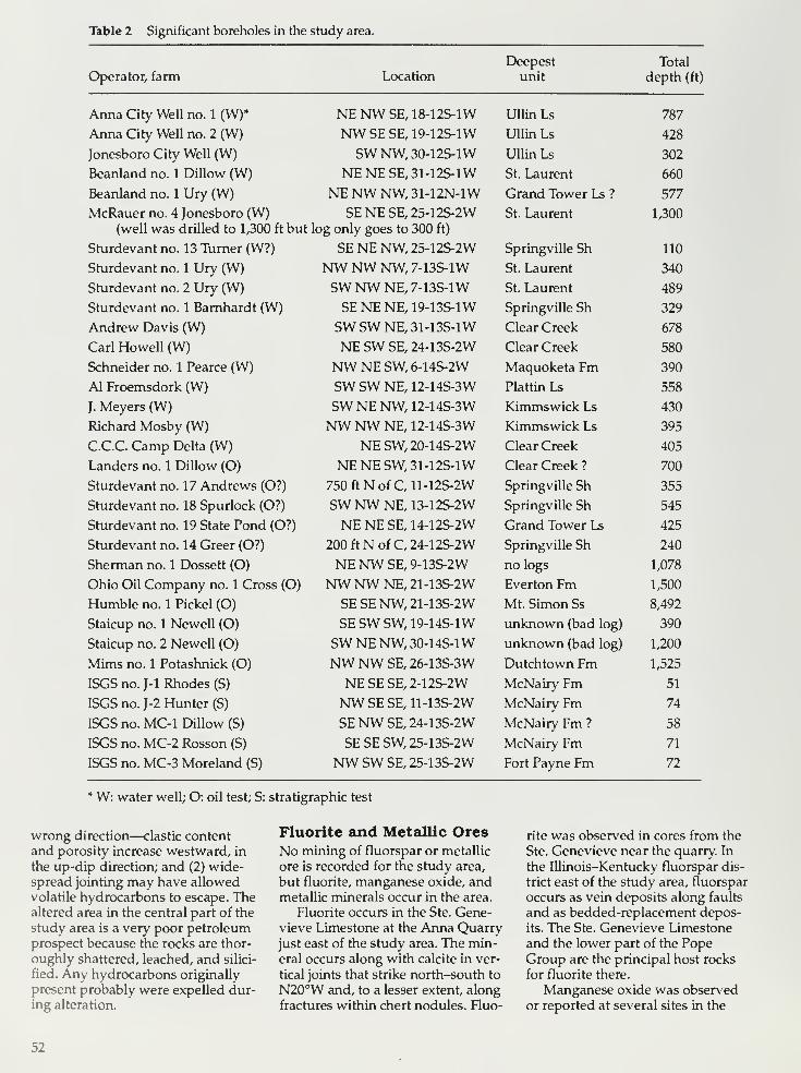
Table 2 Significant boreholes in the study area.
Operator, farm Location
Deepestunit
Total
depth (ft)
Anna City Well no. 1 (W)*
Anna City Well no. 2 (W)
Jonesboro City Well (W)
Beanland no. 1 Dillow (W)
Beanland no. 1 Ury (W)
McRauer no. 4 Jonesboro (W)(well was drilled to 1,300 ft but
Sturdevant no. 13 Turner (W?)
Sturdevant no. 1 Ury (W)
Sturdevant no. 2 Ury (W)
Sturdevant no. 1 Barnhardt (W)
Andrew Davis (W)
Carl Howell (W)
Schneider no. 1 Pearce (W)
Al Froemsdork (W)
J. Meyers (W)
Richard Mosby (W)
C.C.C. Camp Delta (W)
Landers no. 1 Dillow (O)
Sturdevant no. 17 Andrews (O?)
Sturdevant no. 18 Spurlock (O?)
Sturdevant no. 19 State Pond (O?)
Sturdevant no. 14 Greer (O?)
Sherman no. 1 Dossett (O)
Ohio Oil Company no. 1 Cross (O)
Humble no. 1 Pickel (O)
Staicup no. 1 Newell (O)
Staicup no. 2 Newell (O)
Mims no. 1 Potashnick (O)
ISGS no. J-l Rhodes (S)
ISGS no. J-2 Hunter (S)
ISGS no. MC-1 Dillow (S)
ISGS no. MC-2 Rosson (S)
ISGS no. MC-3 Moreland (S)
NE NW SE, 18-12S-1W
NW SE SE, 19-12S-1W
SWNW,30-12S-1W
NE NE SE, 31-12S-1W
NE NW NW, 31-12N-1W
SE NE SE, 25-12S-2Wlog only goes to 300 ft)
SE NE NW, 25-12S-2W
NW NW NW, 7-13S-1W
SW NW NE, 7-13S-1W
SE NE NE, 19-13S-1W
SW SW NE, 31-13S-1W
NE SW SE, 24-13S-2W
NW NE SW, 6-14S-2W
SW SW NE, 12-14S-3W
SW NE NW, 12-14S-3W
NW NW NE, 12-14S-3W
NE SW, 20-14S-2W
NENESW,3M2S-1W750 ft N of C, 11-12S-2W
SW NW NE, 13-12S-2W
NE NE SE, 14-12S-2W
200ftNofC,24-12S-2W
NE NW SE, 9-13S-2W
NW NW NE, 21-13S-2W
SE SE NW, 21-13S-2W
SE SW SW, 19-14S-1W
SW NE NW, 30-14S-1W
NW NW SE, 26-13S-3W
NE SE SE, 2-12S-2W
NW SE SE, 11-13S-2W
SE NW SE, 24-13S-2W
SE SE SW, 25-13S-2W
NW SW SE, 25-13S-2W
Ullin Ls 787
Ullin Ls 428
Ullin Ls 302
St. Laurent 660
Grand Tower Ls ? 577
St. Laurent 1,300
Springville Sh 110
St. Laurent 340
St. Laurent 489
Springville Sh 329
Clear Creek 678
Clear Creek 580
Maquoketa Fm 390
Plattin Ls 558
Kimmswick Ls 430
Kimmswick Ls 395
Clear Creek 405
Clear Creek ? 700
Springville Sh 355
Springville Sh 545
Grand Tower Ls 425
Springville Sh 240
no logs 1,078
Everton Fm 1,500
Mt. Simon Ss 8,492
unknown (bad log) 390
unknown (bad log) 1,200
Dutchtown Fm 1,525
McNairy Fm 51
McNairy Fm 74
McNairy Fm ? 58
McNairy Fm 71
Fort Payne Fm 72
W: water well; O: oil test; S: stratigraphic test
wrong direction—clastic content
and porosity increase westward, in
the up-dip direction; and (2) wide-spread jointing may have allowedvolatile hydrocarbons to escape. Thealtered area in the central part of the
study area is a very poor petroleumprospect because the rocks are thor-
oughly shattered, leached, and silici-
fied. Any hydrocarbons originally
present probably were expelled dur-
ing alteration.
Fluorite and Metallic OresNo mining of fluorspar or metallic
ore is recorded for the study area,
but fluorite, manganese oxide, andmetallic minerals occur in the area.
Fluorite occurs in the Ste. Gene-vieve Limestone at the Anna Quarryjust east of the study area. The min-
eral occurs along with calcite in ver-
tical joints that strike north-south to
N20°W and, to a lesser extent, along
fractures within chert nodules. Fluo-
rite was observed in cores from the
Ste. Genevieve near the quarry. In
the Illinois-Kentucky fluorspar dis-
trict east of the study area, fluorspar
occurs as vein deposits along faults
and as bedded-replacement depos-
its. The Ste. Genevieve Limestone
and the lower part of the PopeGroup are the principal host rocks
for fluorite there.
Manganese oxide was observed
or reported at several sites in the
52
Figure 36 A sample of mammillary manganese dioxide from the St. Laurent For-
mation near the Delta Fault, NE SE SE, Sec. 17, T14S, R2W, Mill Creek Quadrangle.
study area. All manganese findings
are in the St. Laurent Formation(Devonian) along faults near the
margins of the altered area. One site
is in the east bank of a stream near
the Cape Road Fault at the south
edge of the Jonesboro 7.5-Minute
Quadrangle (NW SE NW, Sec. 23,
T13S, R2W). Spheroidal and botry-
oidal pellets of black manganeseoxide encrust altered siliceous lime-
stone at the top of the St. Laurent
Formation about 20 feet above creek
level. A second site is in a small gra-
ben east of the Delta Fault in a gully
in the NE SE SE, Sec. 17, T14S, R2W,Mill Creek Quadrangle. Here, large
mammillary nodules of manganeseoxide (fig. 36) occur in altered silt-
stone of the St. Laurent Formation.
Float of similar material was foundon a hillside southwest of Sexton
Creek in the SW, Sec. 16, T14S, R2W.Manganese oxide also lines joints
that strike N20°W in chert of the
Clear Creek Formation along the
bed of Sexton Creek near the center
of the EV4, Sec. 9, T14S, R2W. A man-ganese prospect pit near Berryville,
NW SE SW, Sec. 23, T12S, R2W,Jonesboro Quadrangle, was reported
by J.E. Lamar (unpublished ISGSfield notes, 1940). Local residents
told Lamar that the pit was workedsecretly around 1905, then concealed
by blasting. Lamar in 1940 observed
a vein in a gully near the reported
site of the prospect pit. The vein wasas much as 12 inches wide and con-
sisted of several parallel stringers of
manganese oxide. It followed the
bedding of "rotted ochreous chert,"
which dipped 10° to 15° east. Lamaralso saw manganese ore along joints
in the chert, and found small pellets
of manganese oxide in a manmadepit about Vs mile north of the gully.
Iron-cemented chert breccia indi-
cated a fault (confirmed by our map-ping) to Lamar. The site reported byLamar is now densely overgrownwith brush and brambles, and wedid not observe any manganese min-erals near Berryville.
Unusually high concentrations of
metals were reported by Erickson et
al. (1987) in cuttings from the Hum-ble no. 1 Pickel oil-test hole in the
Mill Creek Quadrangle. Erickson et
al. (1987) analyzed the cuttings from29 deep wells around the westernand southern borders of Illinois.
Among these wells were one near
Galena, Illinois, in the Upper Missis-
sippi Valley zinc-lead district, andseveral in the Illinois-Kentucky
fluorspar district. The Pickel well
had the highest concentrations of sil-
ver, arsenic, and lead, the secondhighest concentration of molybde-num, and the third highest concen-
tration of copper. The silver content
of samples from the Pickel well wassix times greater than that of anyother well. Nickel and zinc concen-
trations in the Pickel well were not
particularly high, but visible sphaler-
ite crystals were noted in the Bonne-terre Formation, which is the princi-
pal host rock for ore in the southeast
Missouri lead district.
The discovery of high metal con-
tent in the Pickel well raises the pos-
sibility of ore in the study area. ThePickel well is near the west edge of
the altered area, which we think wasformed by hydrothermal activity.
The most likely area for ore at shal-
low depth is along the margins of
the altered area, especially wherelimestones abut against major faults.
53

REFERENCES
Allen, R.S., 1985, Petrology, paleon-
tology and origin of the Clear
Creek Chert (Lower Devonian) in
Union and Jackson Counties,
southwestern Illinois: M.S. thesis,
Southern Illinois University, Car-
bondale, 86 p.
Amsden, T.W., and J.E. Barrick, 1986,
Late Ordovician-Early Silurian
Strata in the Central UnitedStates and the Hirnantian Stage:
Oklahoma Geological Survey,
Bulletin 139, 95 p.
Atherton, Elwood, Charles Collin-
son, and J.A. Lineback, 1975,
Mississippian System, in H.B.
Willman et al., eds., Handbook of
Illinois Stratigraphy, Illinois State
Geological Survey, Bulletin 95,
p. 123-163.
Ball, J.R., 1939, Type section of Bain-
bridge Formation of southeastern
Missouri: American Association
of Petroleum Geologists Bulletin,
v. 23, p. 595-601.
Banaee, Jila, 1981, Microfacies anddepositional environment of the
Bailey Limestone (Lower De-vonian), southwestern Illinois: a
carbonate turbidite: M.S. thesis,
University of Illinois, Urbana,61 p.
Baxter, J.W., and G.R. Desborough,
1965, Areal Geology of the Illinois
Fluorspar District, Part 2, Karbers
Ridge and Rosiclare Quadrangles:
Illinois State Geological Survey,
Circular 385, 40 p.
Baxter, J.W., G.R. Desborough, andC.W. Shaw, 1967, Areal Geologyof the Illinois Fluorspar District,
Part 3, Herod and Shetlerville
Quadrangles: Illinois State Geo-logical Survey, Circular 413, 41 p.
Berg, R.B., and J.M. Masters, 1994,
Geology of Microcrystalline Silica
(Tripoli) Deposits, SouthernmostIllinois: Illinois State Geological
Survey, Circular 555, 89 p.
Borden, W.W., 1874, Report of a geo-
logical survey of Clark and Floyd
Counties, Indiana: Indiana Geo-logical Survey, Annual Report 5,
p. 134-189.
Brower, E.C., 1973, Crinoids fromthe Girardeau Limestone (Ordovi-
cian): Paleontographica Ameri-cana, v. 7, no. 46, p. 263-499.
Buschbach, T.C., 1975, Cambrian Sys-
tem, in H.B. Willman et al., eds.,
Handbook of Illinois Stratigraphy:
Illinois State Geological Survey,
Bulletin 95, p. 34-46.
Clendenin, C.W., CA. Niewendorp,and G.A. Lowell, 1989, Reinter-
pretation of faulting in southeast
Missouri: Geology, v. 17, no. 3,
p. 217-220.
Cluff, R.M., and J.A. Lineback, 1981,
Middle Mississippian Carbonates
of the Illinois Basin: Illinois Geo-logical Society /Illinois State Geo-logical Survey, 88 p.
Cluff, R.M., M.L. Reinbold, and J.A.
Lineback, 1981, The New AlbanyShale Group of Illinois: Illinois
State Geological Survey, Circular
518, 83 p.
Collinson, Charles, L.H. Becker, M.PCarlson, F.H. Dorheim, G.W.James, J.W. Koenig, and D.H.
Swann, 1967, Devonian of the
north-central region, United
States, in H. Oswald, ed., Interna-
tional Symposium on the Devon-ian System: Calgary, v. 1, p. 933-
971.
Collinson, Charles, and ElwoodAtherton, 1975, Devonian System,
in H.B. Willman et al, ed., Hand-book of Illinois Stratigraphy: Illi-
nois State Geological Survey,
Bulletin 95, p. 104-123.
Collinson, Charles, and A.J. Scott,
1958, Age of the Springville Shale
(Mississippian) of Southern Illi-
nois: Illinois State Geological Sur-
vey, Circular 254, 12 p.
Cooper, G.A. et al., 1942, Correlation
of the Devonian Sedimentary for-
mations of North America: Geo-logical Society of America Bulle-
tin, v. 53, p. 1729-1794.
Croneis, Carey, 1944, The Devonianof southeastern Missouri: Illinois
State Geological Survey, Bulletin
68, p. 103-131.
Cumings, E.R., 1901, Use of Bedfordas a formational name: Journal of
Geology, v. 9, p. 232-233.
Dake, C.L., 1918, The Sand andGravel Resources of Missouri:
Missouri Bureau of Geology andMines, vol. XV, 2nd Series, 274 p.
Devera, J.A., 1994, Geologic Map of
the Wolf Lake Quadrangle, South-
ern Illinois: Illinois State Geologi-
cal Survey, Illinois Geologic
Quadrangle 13, scale 1:24,000.
Devera, J.A., and W. John Nelson,
1995, Geologic Map of the CobdenQuadrangle, Southern Illinois:
Illinois State Geological Survey,
Illinois Geologic Quadrangle 16,
scale 1:24,000.
Devera, J.A., W.J. Nelson, and J.M.
Masters, 1994, Geologic Map of
the Mill Creek and McClureQuadrangles in Alexander andUnion Counties, Illinois: Illinois
State Geological Survey, Illinois
Geologic Quadrangle 15, scale
1:24,000.
Englemann, George, 1847, Remarkson the St. Louis Limestone:
American Journal of Science, v. 3,
p. 119-120.
Erickson, R.L., M.S. Erickson, Bar-
bara Chazin, J.W. Baxter, J.M.
Masters, and J.J. Eidel, 1987, Sub-
surface Geochemical Investiga-
tion in Western and Southern
Illinois: A Pilot Study: Illinois
State Geological Survey, Illinois
Mineral Note 98, 45 p.
Fraser, D.R., 1980, Late Pleistocene
fluvial-lacustrine history of the
Hutchins Creek-Clear Creek val-
ley, southern Illinois: M.S. thesis,
Southern Illinois University, Car-
bondale, 123 p.
Glick, E.E., 1982, Stratigraphy andstructure of post-Paleozoic sedi-
ments above the Newport pluton
of northeastern Arkansas: U.S.
Geological Survey, Professional
Paper 1236, p. 151-174.
Handford, C.R., 1986, Facies andbedding sequences in shelf-storm-
deposited carbonates—Fayette-
ville Shale and Pitkin Limestone
54

(Mississippian), Arkansas: Jour-
nal of Sedimentary Petrology,
v. 56, no. 1, p. 123-137.
Harding, T.P., 1985, Seismic charac-
teristics and identification of nega-
tive flower structures, positive
flower structures, and positive
structural inversion: AmericanAssociation of Petroleum Geolo-
gists Bulletin, v. 69, no. 4,
p. 582-600.
Harrison, R.W., in preparation,
Geologic Map of the ThebesQuadrangle, Illinois-Missouri:
U.S. Geological Survey, GQSeries, scale 1:24,000.
Harrison, R.W., and A.P Schultz,
1992, Faulting at Thebes Gap,Illinois-Missouri: implications
for New Madrid tectonism
(abstract): Geological Society of
America, Abstracts with Pro-
grams 1992, p. 190.
Hayes, W.C., and R.D. Knight, 1961,
Cambrian System, in W.B. Howe,coordinator, The Stratigraphic
Succession in Missouri: Division
of Geological Survey and WaterResources, vol. XL, 2nd Series,
p. 14-20.
Heigold, PC., and D.R. Kolata, 1993,
Proterozoic crustal boundary in
the southern part of the Illinois
Basin: Tectonophysics, v. 217,
p. 307-319.
Hershey, O.H., 1894, The Elk Hornarea of St. Peter Sandstone in
northwestern Illinois: AmericanGeologist, v. 14, p. 169-179.
Hildenbrand, T.G., 1984, Rift struc-
ture of the northern Mississippi
Embayment from the analysis of
gravity and magnetic data, in PL.
Gori and W.W. Hays, eds., Pro-
ceedings of the Symposium onthe New Madrid Seismic Zone:
U.S. Geological Survey, OpenFile Report 84-770, p. 168-203.
Jacobson, R.J., and C.P. Weibel, 1993,
Geologic Map of the MakandaQuadrangle, Jackson, Union andWilliamson Couties, Illinois: Illi-
nois State Geological Survey, Illi-
nois Geologic Quadrangle 11,
scale 1:24,000.
Johnson, W.D., 1985, Geologic Mapof the Scott City Quadrangle andpart of the Thebes Quadrangle,Scott and Cape Girardeau Coun-ties, Missouri: U.S. Geological Sur-
vey, Map MF-1803, 2 sheets, scale
1:24,000.
Keyes, C.R., 1894, Paleontology of
Missouri (Part 1): Missouri Geo-logical Survey, v. 4, 271 p.
Kolata, D.R., and W.J. Nelson, 1991,
Tectonic history of the Illinois
Basin, in M.W. Leighton, D.R.
Kolata, D.F Oltz, and J.J. Eidel,
eds., Interior Cratonic Basins,
American Association of Petro-
leum Geologists Memoir, 51,
p. 263-285.
Kolata, D.R., and M.C. Noger, 1991,
Tippecanoe I Subsequence, Mid-dle and Upper Ordovician Series,
in M.W. Leighton, D.R. Kolata,
D.F. Oltz, and J.J. Eidel, eds., Inte-
rior Cratonic Basins: AmericanAssociation of Petroleum Geolo-
gists Memoir 51, p. 89-99.
Kolata, D.R., J.D. Treworgy, and J.M.
Masters, 1981, Structural Frame-work of the Mississippi Embay-ment of Southern Illinois: Illinois
State Geological Survey, Circular
518, 38 p.
Lamar, J.E., 1948, Clay and Shale
Resources of Extreme SouthernIllinois: Illinois State Geological
Survey, Report of Investigations
128, 107 p.
Lamar, J.E., 1953, Siliceous Materials
of Extreme Southern Illinois: Illi-
nois State Geological Survey, Re-
port of Investigations 166, 39 p.
Lamar, J.E., 1957, Chemical Analysesof Illinois Limestones and Dolo-
mites: Illinois State Geological
Survey, Report of Investigations
200, 33 p.
Lamar, J.E., 1959, Limestone Re-
sources of Extreme Southern Illi-
nois: Illinois State Geological
Survey, Report of Investigations
211, 81 p.
Lamar, J.E., and H.B. Willman, 1955,
Illinois Building Stones: Illinois
State Geological Survey, Report of
Investigations 184, 24 p.
Leighton, M.M., G.E. Ekblaw, andC.L. Horberg, 1948, Physiog-
raphic divisions of Illinois: Jour-
nal of Geology, v. 56, p. 16-33.
Lineback, J.A., 1966, Deep-WaterSediments Adjacent to the BordenSiltstone (Mississippian) Delta in
Southern Illinois: Illinois State
Geological Survey, Circular 401,
48 p.
Lineback, J.A., 1972, Lateral Grada-tion of the Salem and St. Louis
Limestones (Middle Mississip-
pian) in Illinois: Illinois State Geo-logical Survey, Circular 474, 21 p.
Lowenstam, H.A., 1949, NiagaranReefs in Illinois and Their Rela-
tion to Oil Accumulation: Illinois
State Geological Survey, Report of
Investigations 145, 36 p.
Martin, J.A., R.D. Knight, and WC.Hayes, 1961, Ordovician System,in W.B. Howe, coordinator, TheStratigraphic Succession in Mis-
souri: Missouri Geological Sur-
vey, v. 40, 2nd Series, p. 20-32.
McBride, E.F and R.L. Folk, 1977,
The Caballos Novaculite revis-
ited: Part II: chert and shale mem-bers and synthesis: Journal of
Sedimentary Petrology, v. 47, no. 3,
p. 1261-1286.
McCracken, M.H., 1971, Structural
Features of Missouri: Missouri
Geological Survey, Report of
Investigations 49, 99 p.
Meents, WE, and D.H. Swann. 1965,
Grand Tower Limestone (Devo-nian) of Southern Illinois: Illinois
State Geological Survey, Circular
389, 34 p.
Middendorf, M.A., 1989, Geologic
Map of the Missouri Portion of
the Ware Quadrangle: Missouri
Geological Survey, scale 1:24,000.
Middendorf, M.A., J.W Whitfield,
and C.E. Robertson, 1988, Geo-logic Map of the Cape Girardeau
Northeast Quadrangle, Missouri:
Missouri Division of Geology andLand Survey, scale 1:33,000.
Moody, C.L., 1949, Mesozoic igne-
ous rocks of the northern GulfCoastal Plain: American Associa-
tion of Petroleum Geologists Bul-
letin, v. 33, p. 1410-1428.
Nelson, W.J., 1991, Structural styles
of the Illinois Basin, in M.W.Leighton, D.R. Kolata, D.F. Oltz,
and J.J. Eidel, eds., Interior Cra-
tonic Basins: American Associa-
tion of Petroleum Geologists,
Memoir 51, p. 209-243.
Nelson, W.J., 1993, Geology of the
Bloomfield Quadrangle, JohnsonCounty, Illinois: Illinois State Geo-logical Survey, Bulletin 99, 30 p.
Nelson, W.J., 1995, Bedrock Geology
of the Paducah l°x2° Quadrangle:
Illinois State Geological Survey,
Bulletin 102.
Nelson, W.J., and R.D. Cole, 1992, Re-
gional intertonguing of lithologic
intervals, Pope (Chester) Group,
Illinois Basin (abstract): AmericanAssociation of Petroleum Geolo-
gists Bulletin, v. 76, no. 8, p. 1282.
Nelson, W.J., and J.A. Devera, 1994,
Geologic Map of the Jonesboro
55

and Ware Quadrangles in UnionCounty, Illinois: Illinois State Geo-logical Survey, Illinois Geologic
Quadrangle 14, scale 1:24,000.
Nelson, W.J., and R.W. Harrison,
1993, Post-Cretaceous faulting at
head of Mississippi Embayment:Geological Society of America,
Abstracts with Programs, North-
Central Section, p. 69-70.
Nelson, W.J., and D.K. Lumm, 1985,
Ste. Genevieve Fault Zone, Mis-
souri and Illinois: U.S. Nuclear
Regulatory Commission NUREG/CR-4333, 94 p.
North, W.G., 1969, The Middle Devo-nian Strata of Southern Illinois:
Illinois State Geological Survey,
Circular 441, 45 p.
North American Stratigraphic Code,
1983, The North American Com-mission on Stratigraphic Nomen-clature: American Association of
Petroleum Geologists Bulletin,
v. 67, no. 5, p. 841-875.
Norton, J.A., 1966, Petrology of the
Lingle Limestone, Union County,
Illinois: M.S. thesis, Southern Illi-
nois University, Carbondale, 101 p.
Olive, W.W., 1980, Geologic Maps of
the Jackson Purchase Area, Ken-tucky: U.S. Geological Survey
Map 1-1217, 11 p. and map.Orr, R.W., 1964, Conodonts from the
Devonian Lingle and Alto Forma-tions of Southern Illinois: Illinois
State Geological Survey, Circular
361, 28 p.
Parmalee, C.W., and C.R. Schroyer,
1921, Further Investigation of
Illinois Fire Clay: Illinois State
Geological Survey, Bulletin 38,
p. 272-417.
Penrose, R.A.F., Jr., 1891, Batesville
region of Arkansas: ArkansasGeological Survey, Annual Re-
port for 1890, v. 1, p. 102-174.
Potter, RE., and W.A. Pryor, 1961,
Dispersal centers of Paleozoic
and later elastics of the upperMississippi Valley and adjacent
areas: Geological Society of Amer-ica Bulletin, v. 72, no. 8, p. 1195-
1294.
Pryor, W.A., 1960, Cretaceous sedi-
mentation in upper Mississippi
embayment: American Associa-
tion of Petroleum Geologists Bul-
letin, v. 44, no. 9, p. 1473-1504.
Pryor, W.A., and C.A. Ross, 1962,
Geology of the Illinois Parts of
the Cairo, LaCenter, and ThebesQuadrangles: Illinois State Geo-
logical Survey, Circular 332, 39 p.,
with map, scale 1:62,500.
Rexroad, C.B., and W.W. Craig, 1971,
Restudy of conodonts from the
Bainbridge Formation (Silurian) at
Lithium, Missouri: Journal of Pale-
ontology, v. 45, no. 4, p. 684-703.
Rogers, J.E., 1972, Silurian andLower Devonian stratigraphy
and paleobasin development, Illi-
nois Basin, central United States:
Ph.D. thesis, University of Illinois,
Urbana-Champaign, 144 p.
Ross, C.A., 1962, Silurian monograp-tids from Illinois: Palaeontology,
v. 5, part 1, p. 59-72.
Sable, E.G., and G.R. Dever, 1990,
Mississippian Rocks in Kentucky:
U.S. Geological Survey, Profes-
sional Paper 1503, 125 p.
St. Clair, Stuart, 1917, Clay deposits
near Mountain Glen, UnionCounty, Illinois: Illinois State Geo-logical Survey, Bulletin 36, p. 71-
83.
Sando, W.J., 1983, Revision of Litho-
strotionella (Coelenterata, Rugosa)
from the Carboniferous and Per-
mian: U.S. Geological Survey, Pro-
fessional Paper 1247, 47 p.
Sargent, M.L., 1991, Sauk Sequence,
Cambrian System through LowerOrdovician Series, in M.W. Leigh-
ton, D.R. Kolata, D.F. Oltz and J.J.
Eidel, eds., Interior Cratonic
Basins: American Association of
Petroleum Geologists Memoir 51,
p. 75-85.
Satterfield, I.R., 1971, Conodontsand stratigraphy of the Girardeau
Limestone (Ordovician) of south-
east Missouri and southwest Illi-
nois: Journal of Paleontology, v. 45,
p. 264-273.
Satterfield, I.R., 1973, Bedrock Geo-logic Map of the Cape Girardeau-
McClure Quadrangles, Southeast-
ern Missouri: Missouri Geological
Survey, Open-File Map OFM-82-73-G1.
Satterfield, I.R., and T.L. Thompson,1975, Seventy-Six Shale, a newmember of the Bainbridge Forma-tion (Silurian) in southeastern
Missouri: Missouri Geological
Survey, Report of Investigations
57, p. 109-119.
Savage, T.E., 1909, The Ordovician
and Silurian formations in Alex-
ander County, Illinois: AmericanJournal of Science, 4th Series, v. 28,
p. 509-519.
Savage, T.E., 1920a, Devonian forma-
tions of Illinois: American Journal
of Science, v. 49, p. 169-182.
Savage, T.E., 1920b, Geology of
Jonesboro 15-Minute Quadrangle,Illinois: Illinois State Geological
Survey, unpublished manuscriptwith geologic map, scale 1:62,500.
Savage, T.E., 1925, Oriskany rocks
in Illinois: American Journal of
Science, 5th Series, v. 10, no. 56,
p. 139-144.
Segar, R.L., 1965, A gravity and mag-netic investigation along the east-
ern flank of the Ozark Uplift:
M.A. thesis, Washington Univer-
sity, St. Louis, Missouri, 163 p.
Shaver, R.H., coordinator, 1985,
Midwestern Basins and ArchesRegion: Correlation of Strati-
graphic Units of North America(COSUNA) Project: AmericanAssociation of Petroleum Geolo-
gists, Tulsa, Oklahoma.Shumard, B.F, 1855, Geological sec-
tion on the Mississippi River
from St. Louis to Commerce: Mis-
souri Geological Survey, AnnualReport 1-2, p. 139-208.
Shumard, B.F, 1859, Observations
on the geology of the county of
Ste. Genevieve, Missouri: Transac-
tions of the Academy of Science
of St. Louis, v. 1, p. 404-105.
Smith, E.A., 1890, Geologic structure
and description of the valley re-
gions adjacent to the Cahaba coal
field, in Report on the CahabaCoal Field (part 2): Alabama Geo-logical Survey, p. 137-180.
Summerfield, M.A., 1983, Silcrete as
a palaeoclimatic indicator: evi-
dence from southern Africa:
Palaeogeography, Palaeoclimatol-
ogy, Palaeoecology, v. 41, p. 65-79.
Swallow, G.C., 1855, The First andSecond Annual Reports of the
Geological Survey of Missouri:
Missouri Geological Survey, 239 p.
Swann, D.H., 1963, Classification of
Genevievian and Chesterian
(Late Mississippian) Rocks in Illi-
nois: Illinois State Geological Sur-
vey, Report of Investigations 216,
91 p.
Swann, D.H., and H.B. Willman,
1961, Megagroups in Illinois:
American Association of Petro-
leum Geologists Bulletin, v. 45,
p. 471-483.
Sweet, W.C., T.L. Thompson, andI.R. Satterfield, 1975, ConodontStratigraphy of the Cape Lime-
stone (Maysvillian) of Eastern
56

Missouri: Missouri Geological
Survey, Report of Investigations
57, p. 1-60.
Templeton, J.S., and H.B. Willman,
1963, Champlainian Series (Mid-
dle Ordovician) in Illinois: Illinois
State Geological Survey, Bulletin
89, 260 p.
Thomas, W.A., 1972, Mississippian
Stratigraphy of Alabama: Geologi-
cal Survey of Alabama, Mono-graph 12, 121 p. and 13 plates.
Thompson, T.L., 1987, Stratigraphic
column for Perry County, Mis-
souri, in Frank Adler, coordinator,
Mid-Continent Region, Correla-
tion of Stratigraphic Units in
North America (COSUNA) Pro-
ject: American Association of
Petroleum Geologists, Tulsa.
Thompson, T.L., 1991, Paleozoic Suc-
cession in Missouri, Part 2: Ordo-vician System: Missouri Geological
Survey, Report of Investigations
70, 282 p.
Thompson, T.L., and I.R. Satterfield,
1975, Stratigraphy and conodontbiostratigraphy of strata conti-
guous to the Ordovician-Silurian
boundary in eastern Missouri:
Missouri Geological Survey,
Report of Investigations 57, part 2,
p. 61-108.
Trace, R.D., and D.H. Amos, 1984,
Stratigraphy and Structure of the
Western Kentucky Fluorspar Dis-
trict: U.S. Geological Survey, Pro-
fessional Paper 1151-D, 41 p.
Ulrich, E.O., 1904, The quarrying
industry in Missouri, in E.R. Buck-
ley and H.A. Buehler, eds.: Mis-
souri Bureau of Geology andMines, 2nd Series, v. 2, p. 109-111.
Weibel, C.R, W.J. Nelson, L.B. Oliver,
and S.P Esling, 1993, Geology of
the Waltersburg Quadrangle,
Pope County, Illinois: Illinois
State Geological Survey, Bulletin
98, 41 p.
Weller, J.M., 1944, Devonian Systemin Southern Illinois: Illinois State
Geological Survey, Bulletin 68,
p. 89-102.
Weller, J.M., 1948, Correlation of the
Mississippian formations of
North America: Geological Soci-
ety of America Bulletin, v. 59, no.
1, p. 91-196.
Weller, J.M., and G.E. Ekblaw, 1940,
Preliminary Geologic Map of
Parts of the Alto Pass, Jonesboro
and Thebes Quadrangles: Illinois
State Geological Survey, Report of
Investigations 70, 26 p. with map,scale 1:62,500.
Weller, Stuart, and Stuart St. Clair,
1928, Geology of Ste. GenevieveCounty, Missouri: Missouri Bureauof Geology and Mines, vol. XXII,
2nd Series, 352 p.
Wheeler, E.F., Michael Lee, and L.C.
Matten, 1987, Dicotyledonous
woods from the Upper Creta-
ceous of southern Illinois: Botani-
cal Journal of the Linnean Society,
v. 95, p. 77-100.
Whitaker, ST., 1988, Silurian Pinna-
cle Reef Distribution in Illinois:
Model for Hydrocarbon Explora-
tion: Illinois State Geological Sur-
vey, Illinois Petroleum 130, 32 p.
White, C.A., 1870, Report on Geo-logical Survey of Iowa: Iowa Geo-logical Survey, v. 1, 391 p.
Whitfield, J.W, and M.M. Midden-dorf, 1988, Geologic Map of the
Neely's Landing Quadrangle,
Missouri: Missouri Division of
Geology and Land Survey, scale
1:33,000.
Wilcox, Ronald E., T.P. Harding, andD.R. Seely, 1973, Basic wrench tec-
tonics: American Association of
Petroleum Geologists Bulletin,
v. 57, no. 1, p. 74-96.
Willman, H.B., and Elwood Ather-
ton, 1975, Silurian System, in H.B.
Willman et al., eds., 1975, Hand-book of Illinois Stratigraphy: Illi-
nois State Geological Survey,
Bulletin 95, p. 87-104.
Woodcock, N.H., and Mike Fischer,
1986, Strike-slip duplexes: Journal
of Structural Geology, v. 8, no. 7,
p. 725-735.
Workman, L.E., and Tracey Gillette,
1956, Subsurface Stratigraphy of
the Kinderhook Series in Illinois:
Illinois State Geological Survey,
Report of Investigations 189, 46 p.
Worthen, A.H., 1866, Geology: Illi-
nois Geological Survey, v. 1, 504 p.
Zartman, R.E., M.R. Brock, A.V.
Heyl, and H.H. Thomas, 1967, K-
Ar and Rb-Sr ages of some alkalic
intrusive rocks from central andeastern United States: AmericanJournal of Science, v. 265, no. 10,
p. 848-870.
57


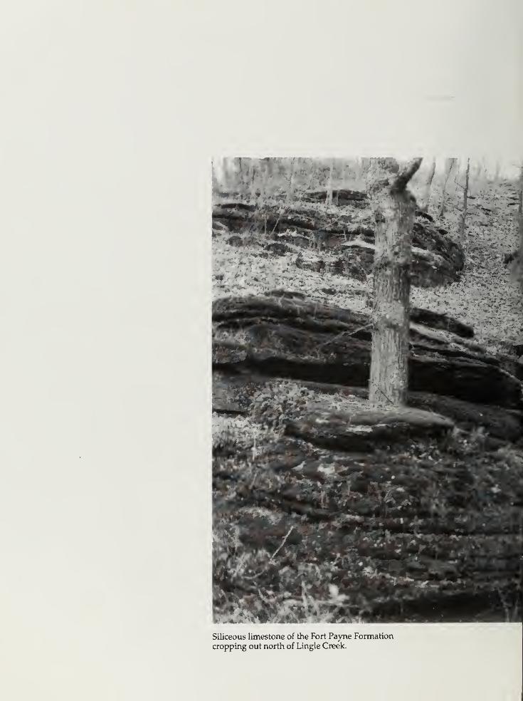
Siliceous limestone of the Fort Payne Formation
cropping out north of Lingle Creek.