Embed Size (px)
Citation preview
California Polytechnic State UniversityDigitalCommons@CalPolyCity & Regional Planning Studios, Projects andWhite Papers City and Regional Planning
Spring 2014
Urban Design Visions for MilpitasVicente del RioCalifornia Polytechnic State University - San Luis Obispo, [email protected]
Hemalata C. DandekarCalifornia Polytechnic State University - San Luis Obispo, [email protected]
Follow this and additional works at: http://digitalcommons.calpoly.edu/crp_wpp
Part of the Urban, Community and Regional Planning Commons
This Other is brought to you for free and open access by the City and Regional Planning at DigitalCommons@CalPoly. It has been accepted forinclusion in City & Regional Planning Studios, Projects and White Papers by an authorized administrator of DigitalCommons@CalPoly. For moreinformation, please contact [email protected].
Recommended CitationPresented to the City of Milpitas Spring April 1, 2014, pages 1-20.
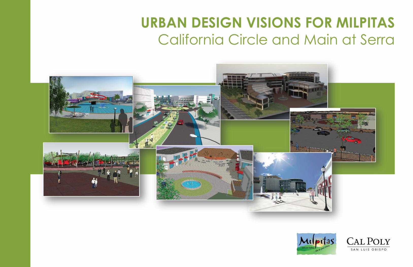
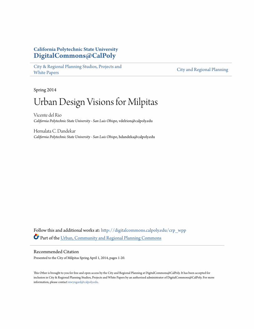
URBAN DESIGN VISIONS FOR MILPITAS California Circle and Main at Serra

URBAN DESIGN VISIONS FOR MILPITAS California Circle and Main at Serra
Prepared by the
CRP 341 Urban Design III StudioBachelor of City and Regional ProgramCity and Regional Planning Department
California Polytechnic State University San Luis Obispo
For the
Department of Planning and Neighborhood ServicesCity of Milpitas
January 21, 2014
CREDITS
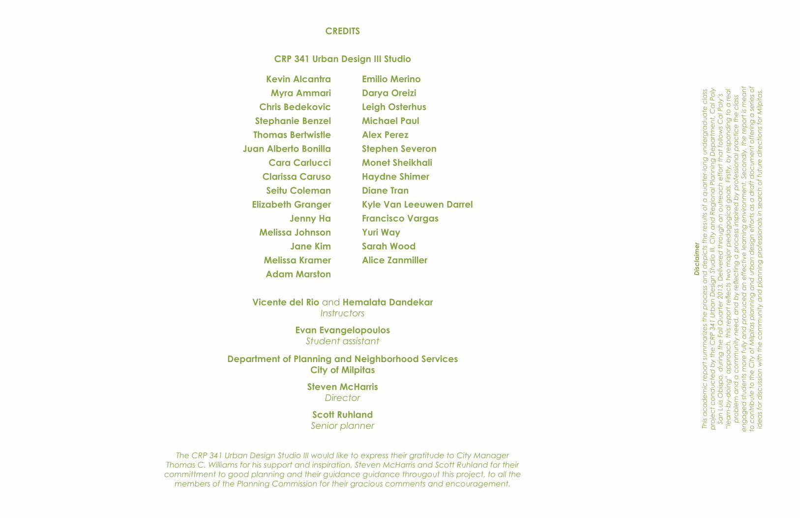
CRP 341 Urban Design III Studio
Kevin Alcantra
Myra Ammari
Chris Bedekovic
Stephanie Benzel
Thomas Bertwistle
Juan Alberto Bonilla
Cara Carlucci
Clarissa Caruso
Seitu Coleman
Elizabeth Granger
Jenny Ha
Melissa Johnson
Jane Kim
Melissa Kramer
Adam Marston
Emilio Merino
Darya Oreizi
Leigh Osterhus
Michael Paul
Alex Perez
Stephen Severon
Monet Sheikhali
Haydne Shimer
Diane Tran
Kyle Van Leeuwen Darrel
Francisco Vargas
Yuri Way
Sarah Wood
Alice Zanmiller
Vicente del Rio and Hemalata DandekarInstructors
Evan EvangelopoulosStudent assistant
Department of Planning and Neighborhood ServicesCity of Milpitas
Steven McHarrisDirector
Scott RuhlandSenior planner
The CRP 341 Urban Design Studio III would like to express their gratitude to City Manager Thomas C. Williams for his support and inspiration, Steven McHarris and Scott Ruhland for their committment to good planning and their guidance guidance througout this project, to all the
members of the Planning Commission for their gracious comments and encouragement.
Dis
cla
ime
rTh
is a
ca
de
mic
rep
ort
su
mm
ariz
es
the
pro
ce
ss a
nd
de
pic
ts t
he
resu
lts o
f a q
ua
rte
r-lo
ng
un
de
rgra
du
ate
cla
ss
pro
jec
t c
on
du
cte
d b
y th
e C
RP
341
Urb
an
De
sign
Stu
dio
III,
City
an
d R
eg
ion
al P
lan
nin
g D
ep
art
me
nt,
Ca
l Po
ly
San
Lu
is O
bisp
o, d
urin
g t
he
Fa
ll Q
ua
rte
r 201
3. D
eliv
ere
d t
hro
ug
h a
n o
utr
ea
ch
eff
ort
th
at
follo
ws
Ca
l Po
ly’s
“l
ea
rn-b
y-d
oin
g”
ap
pro
ac
h, t
his
rep
ort
refle
cts
tw
o m
ajo
r pe
da
go
gic
al g
oa
ls. F
irstly
, by
resp
on
din
g t
o a
rea
l p
rob
lem
an
d a
co
mm
un
ity n
ee
d, a
nd
by
refle
ctin
g a
pro
ce
ss in
spire
d b
y p
rofe
ssio
na
l pra
ctic
e t
he
cla
ss
en
ga
ge
d s
tud
en
ts m
ore
fully
an
d p
rod
uc
ed
an
eff
ec
tive
lea
rnin
g e
nvi
ron
me
nt.
Se
co
nd
ly, t
he
rep
ort
is m
ea
nt
to c
on
trib
ute
to
th
e C
ity o
f Milp
itas
pla
nn
ing
an
d u
rba
n d
esig
n e
ffo
rts
as
a d
raft
do
cu
me
nt
off
erin
g a
se
ries
of
ide
as
for d
iscu
ssio
n w
ith t
he
co
mm
un
ity a
nd
pla
nn
ing
pro
fess
ion
als
in s
ea
rch
of f
utu
re d
irec
tion
s fo
r Milp
itas.
URBAN DESIGN VISIONS FOR MILPITAS California Circle and Main at Serra
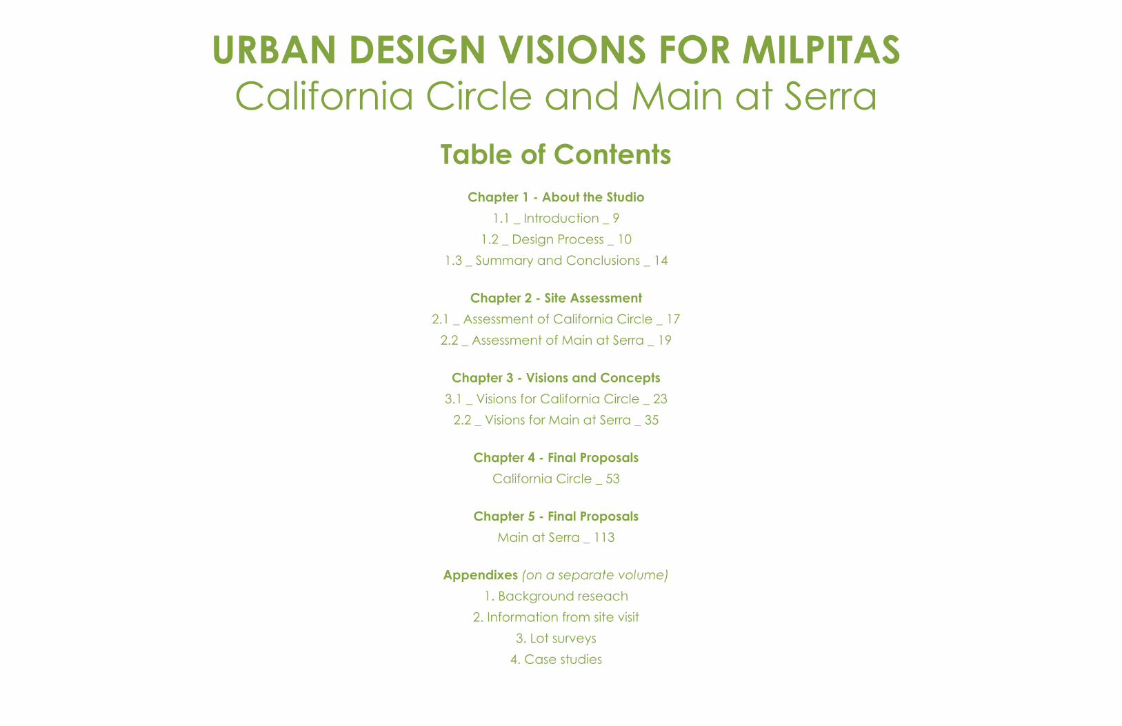
Table of ContentsChapter 1 - About the Studio
1.1 _ Introduction _ 9
1.2 _ Design Process _ 10
1.3 _ Summary and Conclusions _ 14
Chapter 2 - Site Assessment
2.1 _ Assessment of California Circle _ 17
2.2 _ Assessment of Main at Serra _ 19
Chapter 3 - Visions and Concepts
3.1 _ Visions for California Circle _ 23
2.2 _ Visions for Main at Serra _ 35
Chapter 4 - Final Proposals
California Circle _ 53
Chapter 5 - Final Proposals
Main at Serra _ 113
Appendixes (on a separate volume)
1. Background reseach
2. Information from site visit
3. Lot surveys
4. Case studies

Chapter 1About the Studio
URBAN DESIGN VISIONS FOR MILPITAS California Circle and Main at Serra

Page intentionally left blank
9
Urban Design Concepts for Milpitas
Cal Poly San Luis Obispo / City of Milpitas
Chapter 1 Introduction
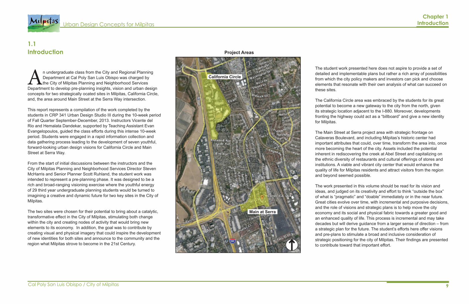
An undergraduate class from the City and Regional Planning Department at Cal Poly San Luis Obispo was charged by the City of Milpitas Planning and Neighborhood Services
Department to develop pre-planning insights, vision and urban design concepts for two strategically ocated sites in Milpitas, California Circle, and, the area around Main Street at the Serra Way intersection.
This report represents a compilation of the work completed by the students in CRP 341 Urban Design Studio III during the 10-week period of Fall Quarter September-December, 2013. Instructors Vicente del Rio and Hemalata Dandekar, supported by Teaching Assistant Evan Evangelopoulos, guided the class efforts during this intense 10-week period. Students were engaged in a rapid information collection and data gathering process leading to the development of seven youthful, forward-looking urban design visions for California Circle and Main Street at Serra Way.
From the start of initial discussions between the instructors and the City of Milpitas Planning and Neighborhood Services Director Steven McHarris and Senior Planner Scott Ruhland, the student work was intended to represent a pre-planning phase. It was designed to be a rich and broad-ranging visioning exercise where the youthful energy of 29 third year undergraduate planning students would be turned to imagining a creative and dynamic future for two key sites in the City of Milpitas.
The two sites were chosen for their potential to bring about a catalytic, transformative effect in the City of Milpitas, stimulating both change within the city and creating nodes of activity that would bring new elements to its economy. In addition, the goal was to contribute by creating visual and physical imagery that could inspire the development of new identities for both sites and announce to the community and the region what Milpitas strove to become in the 21st Century.
The student work presented here does not aspire to provide a set of detailed and implementable plans but rather a rich array of possibilities from which the city policy makers and investors can pick and choose elements that resonate with their own analysis of what can succeed on these sites.
The California Circle area was embraced by the students for its great potential to become a new gateway to the city from the north, given its strategic location adjacent to the I-880. Moreover, developments fronting the highway could act as a “billboard” and give a new identity for Milpitas.
The Main Street at Serra project area with strategic frontage on Calaveras Boulevard, and including Milpitas’s historic center had important attributes that could, over time, transform the area into, once more becoming the heart of the city. Assets included the potential inherent in rediscovering the creek at Abel Street and capitalizing on the ethnic diversity of restaurants and cultural offerings of stores and institutions. A viable and vibrant city center that would enhance the quality of life for Milpitas residents and attract visitors from the region and beyond seemed possible.
The work presented in this volume should be read for its vision and ideas, and judged on its creativity and effort to think “outside the box” of what is “pragmatic” and “doable” immediately or in the near future. Great cities evolve over time, with incremental and purposive decisions, and the role of visions and strategic plans is to help move the city economy and its social and physical fabric towards a greater good and an enhanced quality of life. This process is incremental and may take decades but will derive guidance from a larger sense of direction – from a strategic plan for the future. The student’s efforts here offer visions and pre-plans to stimulate a broad and inclusive consideration of strategic positioning for the city of Milpitas. Their findings are presented to contribute toward that important effort.
California Circle
Main at Serra
Project Areas1.1Introduction
10 Cal Poly San Luis Obispo / City of Milpitas
Urban Design Concepts for MilpitasChapter 1 The Design Process
1.2The Design Process
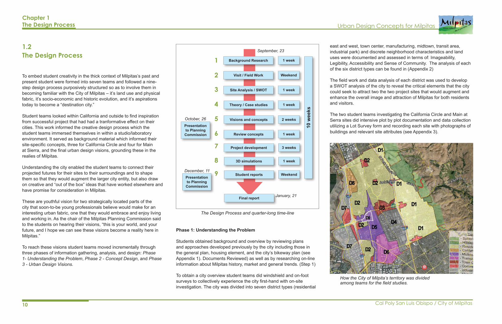
To embed student creativity in the thick context of Milpitas’s past and present student were formed into seven teams and followed a nine-step design process purposively structured so as to involve them in becoming familiar with the City of Milpitas – it’s land use and physical fabric, it’s socio-economic and historic evolution, and it’s aspirations today to become a “destination city.”
Student teams looked within California and outside to find inspiration from successful project that had had a tranformative effect on their cities. This work informed the creative design process which the student teams immersed themselves in within a studio/laboratory environment. It served as background material which informed their site-specific concepts, three for California Circle and four for Main at Sierra, and the final urban design visions, grounding these in the realies of Milpitas.
Understanding the city enabled the student teams to connect their projected futures for their sites to their surroundings and to shape them so that they would augment the larger city entity, but also draw on creative and “out of the box” ideas that have worked elsewhere and have promise for consideration in Milpitas.
These are youthful vision for two strategically located parts of the city that soon-to-be young professionals believe would make for an interesting urban fabric, one that they would embrace and enjoy living and working in. As the chair of the Milpitas Planning Commission said to the students on hearing their visions, “this is your world, and your future, and I hope we can see these visions become a reality here in Milpitas.”
To reach these visions student teams moved incrementally through three phases of information gathering, analysis, and design: Phase 1- Understanding the Problem, Phase 2 - Concept Design, and Phase 3 - Urban Design Visions.
Phase 1: Understanding the Problem
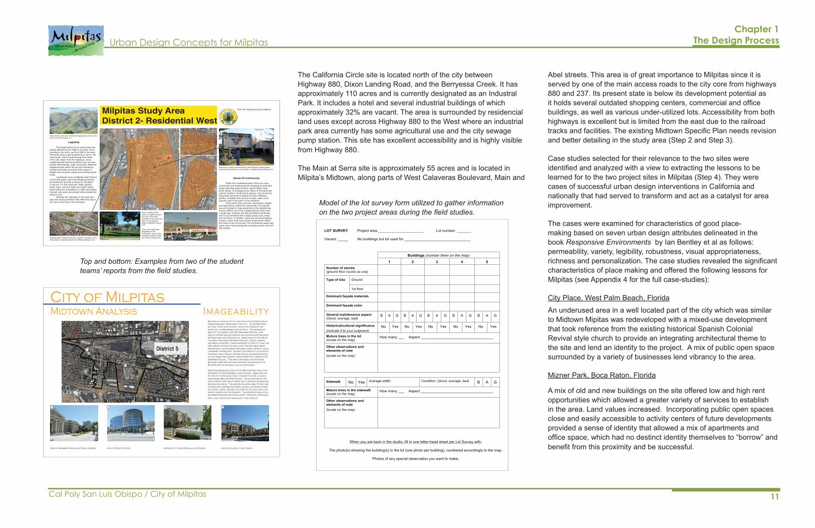
Students obtained background and overview by reviewing plans and approaches developed previously by the city including those in the general plan, housing element, and the city’s bikeway plan (see Appendix 1). Documents Reviewed) as well as by researching on-line information about Milpitas history, market and general trends. (Step 1)
To obtain a city overview student teams did windshield and on-foot surveys to collectively experience the city first-hand with on-site investigation. The city was divided into seven district types (residential
How the City of Milpita’s territory was divided among teams for the field studies.
The Design Process and quarter-long time-line
1
2
3
4
5
6
7
8
9
Background Research
Visit / Field Work
Site Analysis / SWOT
Theory / Case studies
Visions and concepts
Review concepts
Project development
3D simulations
Student reports
Final report
1 week
Weekend
1 week
1 week
2 weeks
1 week
3 weeks
1 week
Weekend
Presentation to Planning
Commission
Presentation to Planning
Commission
10 w
eeks
September, 23
October, 26
December, 11
January, 21
east and west, town center, manufacturing, midtown, transit area, industrial park) and discrete neighborhood characteristics and land uses were documented and assessed in terms of: Imageability, Legibility, Accessibility and Sense of Community. The analysis of each of the six district types can be found in (Appendix 2)
The field work and data analysis of each district was used to develop a SWOT analysis of the city to reveal the critical elements that the city could seek to attract two the two project sites that would augment and enhance the overall image and attraction of Milpitas for both residents and visitors.
The two student teams investigating the California Circle and Main at Serra sites did intensive plot by plot documentation and data collection utilizing a Lot Survey form and recording each site with photographs of buildings and relevant site attributes (see Appendix 3).
11
Urban Design Concepts for Milpitas
Cal Poly San Luis Obispo / City of Milpitas
Chapter 1 The Design Process
Abel streets. This area is of great importance to Milpitas since it is served by one of the main access roads to the city core from highways 880 and 237. Its present state is below its development potential as it holds several outdated shopping centers, commercial and office buildings, as well as various under-utilized lots. Accessibility from both highways is excellent but is limited from the east due to the railroad tracks and facilities. The existing Midtown Specific Plan needs revision and better detailing in the study area (Step 2 and Step 3).
Case studies selected for their relevance to the two sites were identified and analyzed with a view to extracting the lessons to be learned for to the two project sites in Milpitas (Step 4). They were cases of successful urban design interventions in California and nationally that had served to transform and act as a catalyst for area improvement.
The cases were examined for characteristics of good place-making based on seven urban design attributes delineated in the book Responsive Environments by Ian Bentley et al as follows: permeability, variety, legibility, robustness, visual appropriateness, richness and personalization. The case studies revealed the significant characteristics of place making and offered the following lessons for Milpitas (see Appendix 4 for the full case-studies):
City Place, West Palm Beach, Florida
An underused area in a well located part of the city which was similar to Midtown Mipitas was redeveloped with a mixed-use development that took reference from the existing historical Spanish Colonial Revival style church to provide an integrating architectural theme to the site and lend an identity to the project. A mix of public open space surrounded by a variety of businesses lend vibrancy to the area.
Mizner Park, Boca Raton, Florida
A mix of old and new buildings on the site offered low and high rent opportunities which allowed a greater variety of services to establish in the area. Land values increased. Incorporating public open spaces close and easily accessible to activity centers of future developments provided a sense of identity that allowed a mix of apartments and office space, which had no destinct identity themselves to “borrow” and benefit from this proximity and be successful.
Sense Of Community
Within the residential areas, there are many community and meeting places including several park areas with large grassy lawns, sports fields, trails, picnic tables, and playgrounds. Many of the parks are used by families. Youth sports games, such as soccer, bring large amounts of people to parks. Birthday parties, complete with bounce houses, seem to be popular uses in the park on the weekend. There were many schools, elementary, middle, and high school, within the community. The schools were all located in close proximity to the neighboring homes. Within one of the neighborhoods, there was a small lake, however the lake prohibited swimming, and it was furnished with a large grassy area, trees, and fountains. In addition, there are several shopping centers, which hold many ethnic shops which reflect the make of the community. The commercial areas had many cars in the parking lots, portraying them to be full with people.
Legibility
The large portion of our study area was clearly defined by the I-880 to the west, Dixon Landing to the north, and the I-680 to the east. The study area is also bisected by a set of rail road tracks, which travel through the center of the site. Apart from the highways, many neighborhoods have boundaries such as main streets (Abel Street), walls, and parks. Different neighborhoods within the city are marked by architectural style as well as other signs of wealth such as green yards and recently paved roads. Landmarks such as Milpitas High School, community parks, and local shopping centers are present to provide a sense of orientation in the city. For the most part, traffic signals, traffic signs, and bus stops are highly visible. Street grids are orientated in a clear and legible manner, and signs are posted when streets are going to end. Besides the highways to the west and east, the most prominent view within the city is the view to the hills to the northeast.
Milpitas Study AreaDistrict 2- Residential West
Dixon Laniding Park acts as a gathering spot for local community activities in the suburban area on the western edge of Milpitas (Figure 2.3).
Due to the high Asian population in the community, many of the shopping centers reflect the culture (Figure 2.4).Highway 880 clearly defines the western boundary of the
the western residential desitrict of Milpitas (Figure 2.2).
Views to the north and northwest display the scenic views around the city (Figure 2.1).
Schools are highly concentrated in the suburban areas further enhancing the sense on community in neighborhoods (Figure 2.5).
Figure 2.2
Figure 2.1
Figure 2.3
Figure 2.4
Figure 2.5
CRP 341 Alcantra Carlucci Merino
City of MilpitasMidtown Analysis Imageability
1
1
View of Grammar School and Public Library. View of Health Center. Entrance to Terra Serena Luna Condos north end view of the Condos
1
Milpitas is a mixture of old and new developments scat-tered randomly throughout the city. In the Midtown section there were several new developments that stood out as memorable and distinct. The redevelop-ment of the library, historic Grammar School, and health center are enchanting and an excellent balance between new and updated old. Image one is a picture of the newly restored Grammar School, Public Library, and Health Center. It was important to the City that the new library integrated well with the restored Gram-mar School, which makes this area iconic, distinct, and a landmark for Milpitas. Across the street is location of the newly built Health Center, which has similar styles to the library but doesn’t over power the charm of the Grammar School. This area captured our attention because there are not many historic buildings left in Milpitas and its historic look is captivating.
Another memorable area of the Midtown section is the entrance to Terra Serena Luna Condos. Image two is a picture of these newly built condos that are located in-between Abel and Main Street. On either side of the development are public parks that contain playgrounds and seating areas. The sidewalks along Abel Street are planted with shrubs and trees, as well as having charm-ing street lamps. Behind the complex is a pool and com-munity center for the tenants. The architectural style was Mediterranean with balconies, terraces, open walk ways, and vegetation throughout the complex.
2 2
2
LOT SURVEY Project area ______________________ Lot number: _______
Vacant: _____ No buildings but lot used for ________________________________
Buildings (number them on the map)
1 2 3 4 5 Number of stories (ground floor counts as one)
Type of Use Ground
1st floor
Dominant façade materials
Dominant façade color
General maintenance aspect (Good, average, bad)
B A G B A G B A G B A G B A G
Historical/cultural significance (Indicate if its your judgment)
No Yes No Yes No Yes No Yes No Yes
Muture trees in the lot (locate on the map)
How many ___ Aspect ___________________________________
Other observations and elements of note (locate on the map)
Sidewalk No Yes Average width: Condition: (Good, average, bad) B A G
Mature trees in the sidewalk (locate on the map)
How many ___ Aspect ___________________________________
Other observations and elements of note (locate on the map)
When you are back in the studio, fill in one letter-head sheet per Lot Survey with:
The photo(s) showing the building(s) in the lot (one photo per building), numbered accordingly to the map.
Photos of any special observation you want to make.
Top and bottom: Examples from two of the student teams’ reports from the field studies.
Model of the lot survey form utilized to gather information on the two project areas during the field studies.
The California Circle site is located north of the city between Highway 880, Dixon Landing Road, and the Berryessa Creek. It has approximately 110 acres and is currently designated as an Industral Park. It includes a hotel and several industrial buildings of which approximately 32% are vacant. The area is surrounded by residencial land uses except across Highway 880 to the West where an industrial park area currently has some agricultural use and the city sewage pump station. This site has excellent accessibility and is highly visible from Highway 880.
The Main at Serra site is approximately 55 acres and is located in Milpita’s Midtown, along parts of West Calaveras Boulevard, Main and
12 Cal Poly San Luis Obispo / City of Milpitas
Urban Design Concepts for Milpitas
Valencia Town Center, Valencia, California
Emphasizing accessibility and legibility, the town center provides small plazas and malls for pedestrian enjoyment along walkways through the shopping centers. Good signage enhances way-finding through the complex and the mix of housing, retail and dining attracts a divese population.
Downtown Brea, California
Restoring two icons of the historic but dilapidated downtown - the “Welcome to Brea” sign and Charlie’s Clock with it’s “Good Old Brea” sign provided a connection to past history and an identity to this site. This suburban, small town community benefits from access to a walkable downtown in which activities such as a Tuesday night Farmers Market, movie theater, shopping and specialty restaurants attract people from the surrounding area.
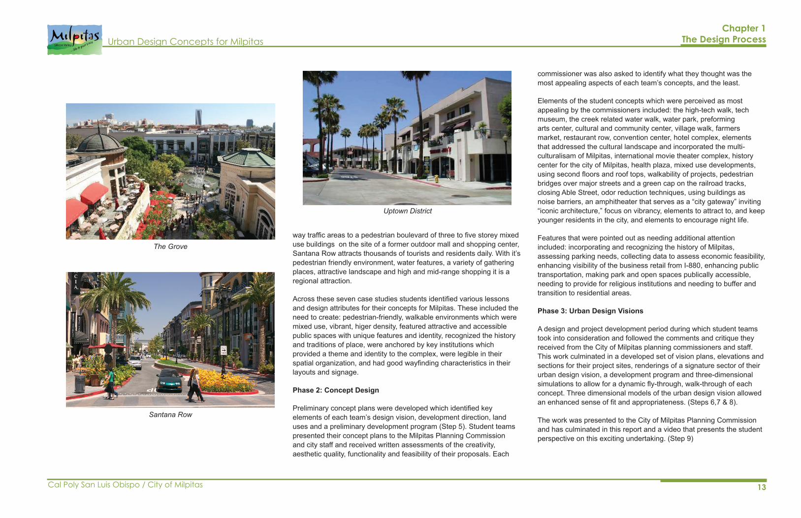
Uptown District, San Diego, California
Located on the site of an abandoned Sears store and parking lot, this project includes a mix of housing units, retail and commercial and a community center. The development was designed in a variety of architectural styles and richly landscaped open spaces to provide recreational opportunities for residents. The Hillcrest sign, a landmark over the intersection of two major streests serves to create an identity and provides a sense of place.
The Grove, Los Angeles, California
Proximate to, and connected with, a historic Farmer’s Market and adobe, the Grove features a central street through the site which is European themed, has a trolley line and brick paving to provide organization and legability to the complex. Two and three-storey buildings allow tenants leeway to change facades and personalize their facilities. The configuration of buildings is designed to create small and medium sized outdoor malls spaces for seating and watching, and allow pedestrians to interact freely. Landmarks at strategic locations along the main axis provide focal points of identity.
Santana Row, San Jose, California
The largest mixed use project to date in San Jose this project is an ambitious retrofit of retail and residential space. Transitioning from two
Valencia Town Center
Downtown BreaMizner Park
City Place
Chapter 1 The Design Process
13
Urban Design Concepts for Milpitas
Cal Poly San Luis Obispo / City of Milpitas
way traffic areas to a pedestrian boulevard of three to five storey mixed use buildings on the site of a former outdoor mall and shopping center, Santana Row attracts thousands of tourists and residents daily. With it’s pedestrian friendly environment, water features, a variety of gathering places, attractive landscape and high and mid-range shopping it is a regional attraction.
Across these seven case studies students identified various lessons and design attributes for their concepts for Milpitas. These included the need to create: pedestrian-friendly, walkable environments which were mixed use, vibrant, higer density, featured attractive and accessible public spaces with unique features and identity, recognized the history and traditions of place, were anchored by key institutions which provided a theme and identity to the complex, were legible in their spatial organization, and had good wayfinding characteristics in their layouts and signage.
Phase 2: Concept Design
Preliminary concept plans were developed which identified key elements of each team’s design vision, development direction, land uses and a preliminary development program (Step 5). Student teams presented their concept plans to the Milpitas Planning Commission and city staff and received written assessments of the creativity, aesthetic quality, functionality and feasibility of their proposals. Each
commissioner was also asked to identify what they thought was the most appealing aspects of each team’s concepts, and the least.
Elements of the student concepts which were perceived as most appealing by the commissioners included: the high-tech walk, tech museum, the creek related water walk, water park, preforming arts center, cultural and community center, village walk, farmers market, restaurant row, convention center, hotel complex, elements that addressed the cultural landscape and incorporated the multi-culturalisam of Milpitas, international movie theater complex, history center for the city of Milpitas, health plaza, mixed use developments, using second floors and roof tops, walkability of projects, pedestrian bridges over major streets and a green cap on the railroad tracks, closing Able Street, odor reduction techniques, using buildings as noise barriers, an amphitheater that serves as a “city gateway” inviting “iconic architecture,” focus on vibrancy, elements to attract to, and keep younger residents in the city, and elements to encourage night life.
Features that were pointed out as needing additional attention included: incorporating and recognizing the history of Milpitas, assessing parking needs, collecting data to assess economic feasibility, enhancing visibility of the business retail from I-880, enhancing public transportation, making park and open spaces publically accessible, needing to provide for religious institutions and needing to buffer and transition to residential areas.
Phase 3: Urban Design Visions
A design and project development period during which student teams took into consideration and followed the comments and critique they received from the City of Milpitas planning commissioners and staff. This work culminated in a developed set of vision plans, elevations and sections for their project sites, renderings of a signature sector of their urban design vision, a development program and three-dimensional simulations to allow for a dynamic fly-through, walk-through of each concept. Three dimensional models of the urban design vision allowed an enhanced sense of fit and appropriateness. (Steps 6,7 & 8).
The work was presented to the City of Milpitas Planning Commission and has culminated in this report and a video that presents the student perspective on this exciting undertaking. (Step 9)
Uptown District
The Grove
Santana Row
Chapter 1The Design Process
14 Cal Poly San Luis Obispo / City of Milpitas
Urban Design Concepts for MilpitasChapter 1 The Design Process
The student work compiled in this report has the virtue of bringing several solutions and possibilities that might be considered by investors and policy makers when exploring the capacity and potential of two significant Milpitas sites – California Circle and Main at Serra. The urban design ideas presented by the students identify a wide range of possibilities that might, with creative mixing and matching, provide workable, successful, alternatives for future development.
The student work presented in this report gives physical form through their renditions of seven alternatives. They present sometimes complementary, sometimes competitive visions for the two sites. Collectively they provide a rich tapestry of possible interventions that the City of Milpitas decision and policy makers might, in conjunction with private sector entities, undertake to make these catalytic sites ones that initiate a change in the overall identity and sense of place of the city.
1.3
Summary and Conclusions
Student teams developed three discrete and different urban design visions for California Circle and four for Main at Serra. Detailed delineation of the seven visions is provided in Chapters 4 and 5 of this report. Key elements of these designs:
California Circle:
Team 1: Benzel, Johnson, Shimer, Vargas, Zanmiller Waterview Plaza
With a focus on technology, sustainability and community this design features:
• a waterpark which is a north entry gateway
• core plaza
• business incubator
• creek walk as a focal point for recreational use
• hotel
Team 2: Bonilla, Coleman, Ha, SheikhaliCosmo Center
With a focus on creating a Live-Work-Play complex which is attractive to the local multicultural, technology rich community this design features:
• Open Air Amphitheater as Gateway
• Cultural Complex
• Freeway Buffer of Buildings such as Parking Structures with animated facades
• Milpitas Tech Museum
• Residential over Commercial and Parking
Team 3: Bertwistle, Perez, Severon,WayThe Circle
With a focus on recreational, educational, and cultural activities and seeking to create a space that will be a destination for experiencing ethnic cuisine and for artistic expression this design features:
• Cultural Center
• Central Plaza with stage and space for community events such as farmers market
• Terraced parks radiating from the central plaza up to the height of the creek levy
• Creek walk
Main at Serra
Team 4: Caruso, Granger, Merino, Van LeeuwenThe Main Connection
Celebrating the history of Milpitas and it’s cultural richness this design features:
• A semi-circular plaza forming a gateway into Serra
• Green median-rich treatment of Serra
• A plaza at the terminus of Serra with a mural depicting the history of Milpitas
• A cultural history museum
Team 5: Alcantara, Bedekovic, Kim, TranThe Core
Increasing and maximizing pedestrian permeability by restoring the creek-side and creating a connectivity grid this design features:
• A Gateway at Serra Boulavard
• Convention Center with Hotel
• Art District with Plaza and Art Center
• Residential Hotel
• Restored Creek at Able Street
• A Multi-Screen Movie Theater at terminus of Serra
Team 6: Marston, Oreizi, Paul, WoodHOTSPOT
A commercial-based development anchors this design which features:
• A Performing Arts Center
• High Tech Walk between Main and the rail road tracks
• Large mixed use buildings which create a raised community platform on top of retail
• Open public space and a Community Center
Team 7: Ammari, Carlucci, Kramer, OsterhusMilpitas Main
• A bridge between a hotel and convention center form a visual gateway to the site in this design which features:
• A Hotel and Convention Center to lend identity to the city
• A Cultural Center with movie theater, museum and grocery store
• A Restaurant Row along Main
Chapter 2Site Assessment
URBAN DESIGN VISIONS FOR MILPITAS California Circle and Main at Serra

Page intentionally left blank
17
Urban Design Concepts for Milpitas
Cal Poly San Luis Obispo / City of Milpitas
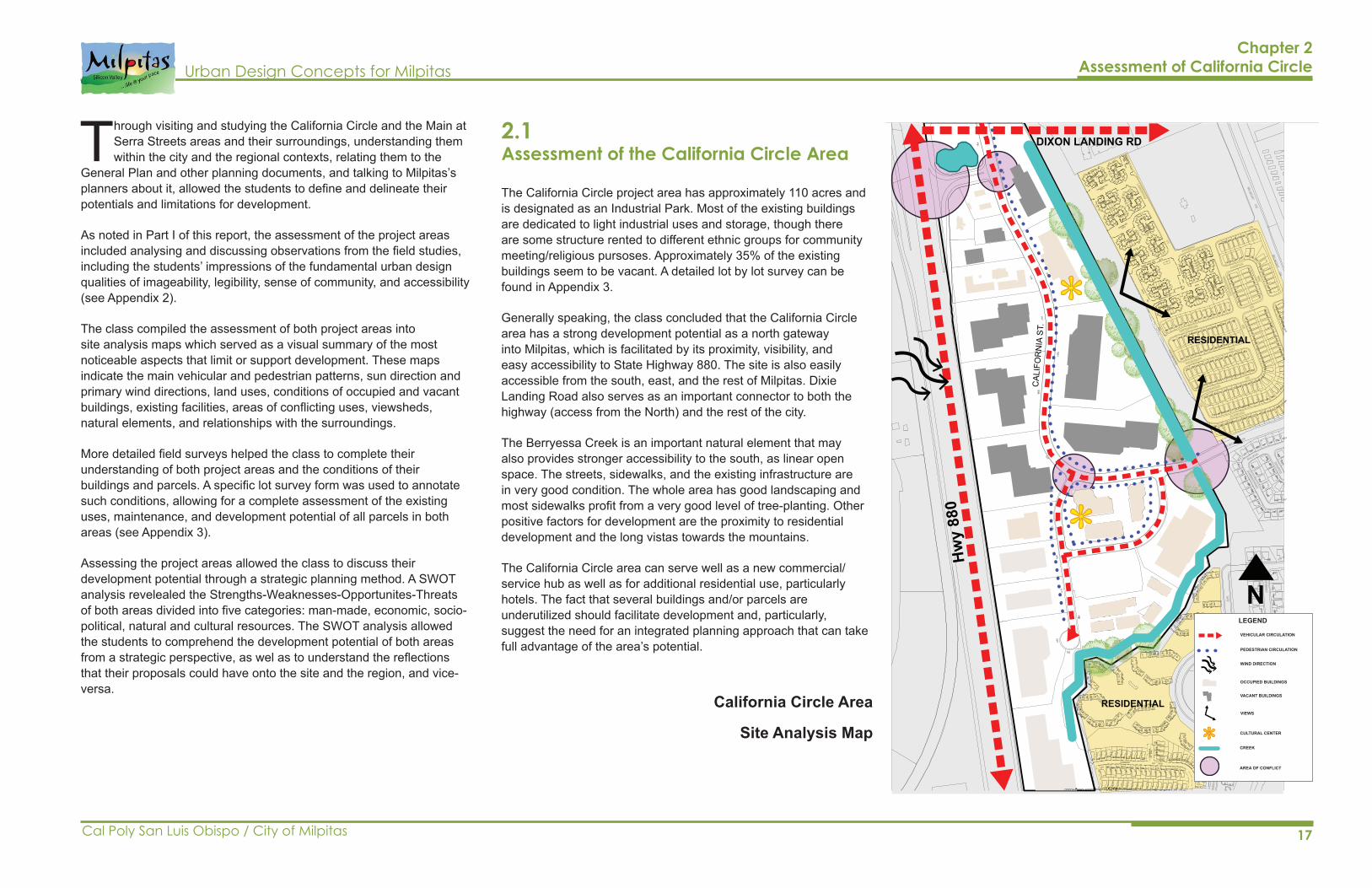
The California Circle project area has approximately 110 acres and is designated as an Industrial Park. Most of the existing buildings are dedicated to light industrial uses and storage, though there are some structure rented to different ethnic groups for community meeting/religious pursoses. Approximately 35% of the existing buildings seem to be vacant. A detailed lot by lot survey can be found in Appendix 3.
Generally speaking, the class concluded that the California Circle area has a strong development potential as a north gateway into Milpitas, which is facilitated by its proximity, visibility, and easy accessibility to State Highway 880. The site is also easily accessible from the south, east, and the rest of Milpitas. Dixie Landing Road also serves as an important connector to both the highway (access from the North) and the rest of the city.
The Berryessa Creek is an important natural element that may also provides stronger accessibility to the south, as linear open space. The streets, sidewalks, and the existing infrastructure are in very good condition. The whole area has good landscaping and most sidewalks profit from a very good level of tree-planting. Other positive factors for development are the proximity to residential development and the long vistas towards the mountains.
The California Circle area can serve well as a new commercial/service hub as well as for additional residential use, particularly hotels. The fact that several buildings and/or parcels are underutilized should facilitate development and, particularly, suggest the need for an integrated planning approach that can take full advantage of the area’s potential.
2.1 Assessment of the California Circle Area
Chapter 2 Assessment of California Circle
Through visiting and studying the California Circle and the Main at Serra Streets areas and their surroundings, understanding them within the city and the regional contexts, relating them to the
General Plan and other planning documents, and talking to Milpitas’s planners about it, allowed the students to define and delineate their potentials and limitations for development.
As noted in Part I of this report, the assessment of the project areas included analysing and discussing observations from the field studies, including the students’ impressions of the fundamental urban design qualities of imageability, legibility, sense of community, and accessibility (see Appendix 2).
The class compiled the assessment of both project areas into site analysis maps which served as a visual summary of the most noticeable aspects that limit or support development. These maps indicate the main vehicular and pedestrian patterns, sun direction and primary wind directions, land uses, conditions of occupied and vacant buildings, existing facilities, areas of conflicting uses, viewsheds, natural elements, and relationships with the surroundings.
More detailed field surveys helped the class to complete their understanding of both project areas and the conditions of their buildings and parcels. A specific lot survey form was used to annotate such conditions, allowing for a complete assessment of the existing uses, maintenance, and development potential of all parcels in both areas (see Appendix 3).
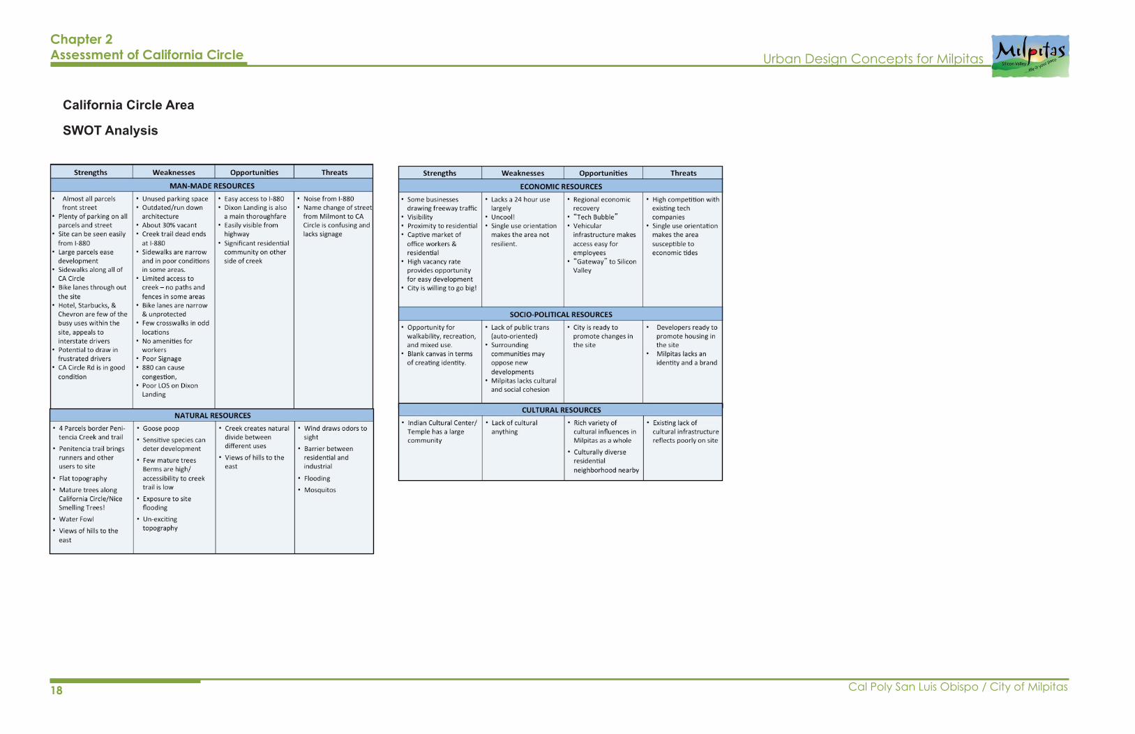
Assessing the project areas allowed the class to discuss their development potential through a strategic planning method. A SWOT analysis revelealed the Strengths-Weaknesses-Opportunites-Threats of both areas divided into five categories: man-made, economic, socio-political, natural and cultural resources. The SWOT analysis allowed the students to comprehend the development potential of both areas from a strategic perspective, as wel as to understand the reflections that their proposals could have onto the site and the region, and vice-versa.
California Circle Area
Site Analysis Map
*
*
Hw
y 88
0
CAL
IFO
RN
IA S
T.
RESIDENTIAL
RESIDENTIAL
DIXON LANDING RD
LEGEND
*
VEHICULAR CIRCULATION
PEDESTRIAN CIRCULATION
WIND DIRECTION
OCCUPIED BUILDINGS
VACANT BUILDINGS
VIEWS
CULTURAL CENTER
CREEK
AREA OF CONFLICT
N
18 Cal Poly San Luis Obispo / City of Milpitas
Urban Design Concepts for Milpitas
Chapter 2 Assessment of California Circle
California Circle Area
SWOT Analysis
19
Urban Design Concepts for Milpitas
Cal Poly San Luis Obispo / City of Milpitas
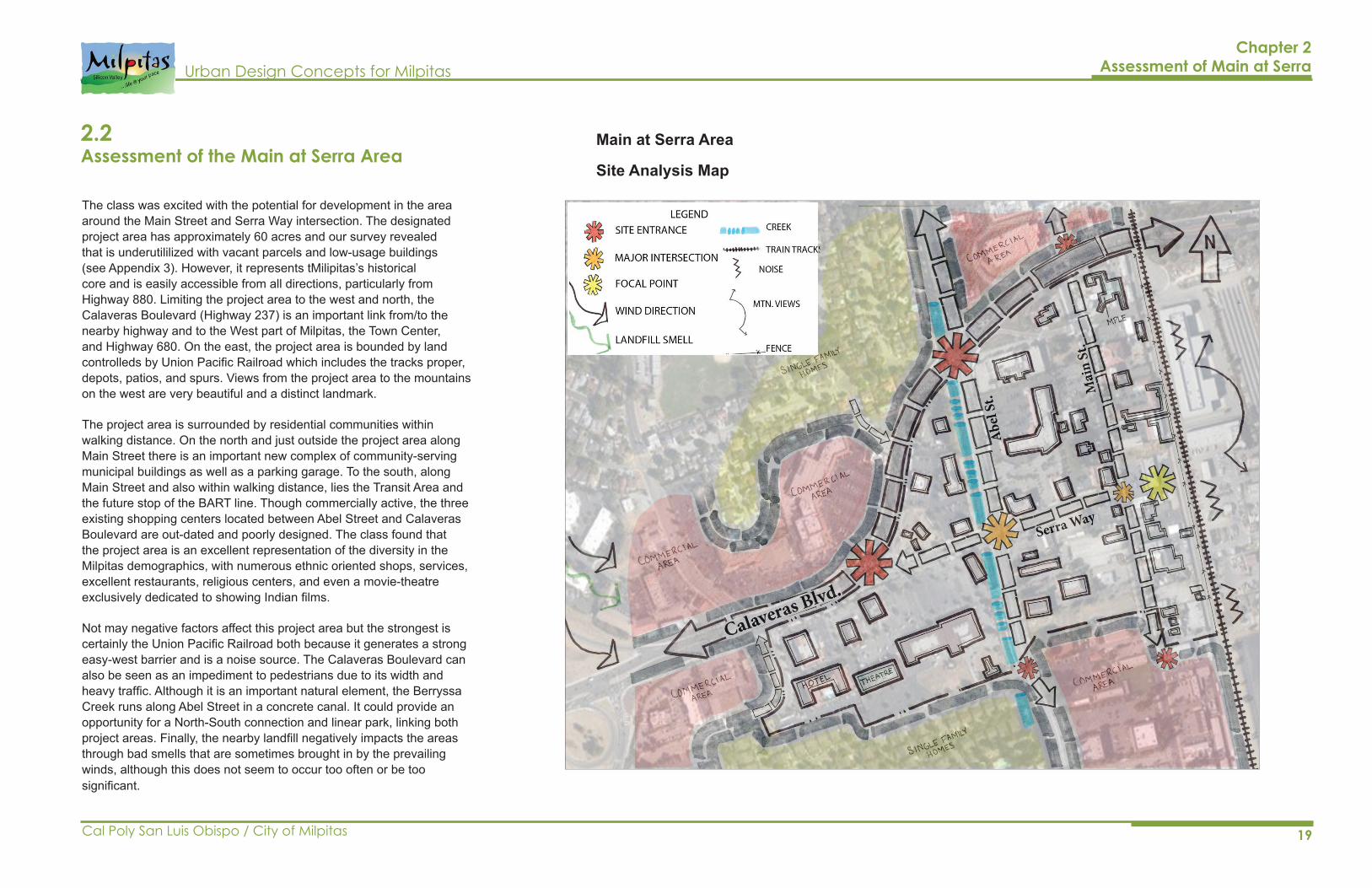
Chapter 2Assessment of Main at Serra
2.2 Assessment of the Main at Serra Area
Main at Serra Area
Site Analysis Map
The class was excited with the potential for development in the area around the Main Street and Serra Way intersection. The designated project area has approximately 60 acres and our survey revealed that is underutililized with vacant parcels and low-usage buildings (see Appendix 3). However, it represents tMilipitas’s historical core and is easily accessible from all directions, particularly from Highway 880. Limiting the project area to the west and north, the Calaveras Boulevard (Highway 237) is an important link from/to the nearby highway and to the West part of Milpitas, the Town Center, and Highway 680. On the east, the project area is bounded by land controlleds by Union Pacific Railroad which includes the tracks proper, depots, patios, and spurs. Views from the project area to the mountains on the west are very beautiful and a distinct landmark.
The project area is surrounded by residential communities within walking distance. On the north and just outside the project area along Main Street there is an important new complex of community-serving municipal buildings as well as a parking garage. To the south, along Main Street and also within walking distance, lies the Transit Area and the future stop of the BART line. Though commercially active, the three existing shopping centers located between Abel Street and Calaveras Boulevard are out-dated and poorly designed. The class found that the project area is an excellent representation of the diversity in the Milpitas demographics, with numerous ethnic oriented shops, services, excellent restaurants, religious centers, and even a movie-theatre exclusively dedicated to showing Indian films.
Not may negative factors affect this project area but the strongest is certainly the Union Pacific Railroad both because it generates a strong easy-west barrier and is a noise source. The Calaveras Boulevard can also be seen as an impediment to pedestrians due to its width and heavy traffic. Although it is an important natural element, the Berryssa Creek runs along Abel Street in a concrete canal. It could provide an opportunity for a North-South connection and linear park, linking both project areas. Finally, the nearby landfill negatively impacts the areas through bad smells that are sometimes brought in by the prevailing winds, although this does not seem to occur too often or be too significant.

20 Cal Poly San Luis Obispo / City of Milpitas
Urban Design Concepts for Milpitas
Chapter 2 Assessment of Main at Serra
Main at Serra Area
SWOT Analysis