Embed Size (px)
Citation preview

Seven Sisters – North East India
STATISTICAL PRESENTATION

NAGALAND

→ Dimapur, Mokokchung, Tuensang, Wokha, Mon and Zunheboto are some of the key cities in the state.
→ Nagaland has four soil types - Inceptisols (66 per cent), Ultisols (23.8 per cent), Entisols (7.3 per cent) and Alfisols (2.9 per cent). The major crops of the state are paddy, maize, sugarcane, potato and tea.→ Nagaland is located in the Northeast
of India. The state is surrounded by Myanmar in the East, Arunachal Pradesh in the North, Assam in the West, and Manipur in the South.
→ English is the official language and the medium of education. Sixty different dialects of Sino-Tibetan language are spoken in the state.
Parameters Nagaland
Capital KohimaGeographical area (sq km) 16,579Administrative districts (No) 11Population density (persons per sq km)* 119
Total population (million)* 1.9 Male population (million)* 1.0 Female population (million)* 0.9
Sex ratio (females per 1,000 males)* 931
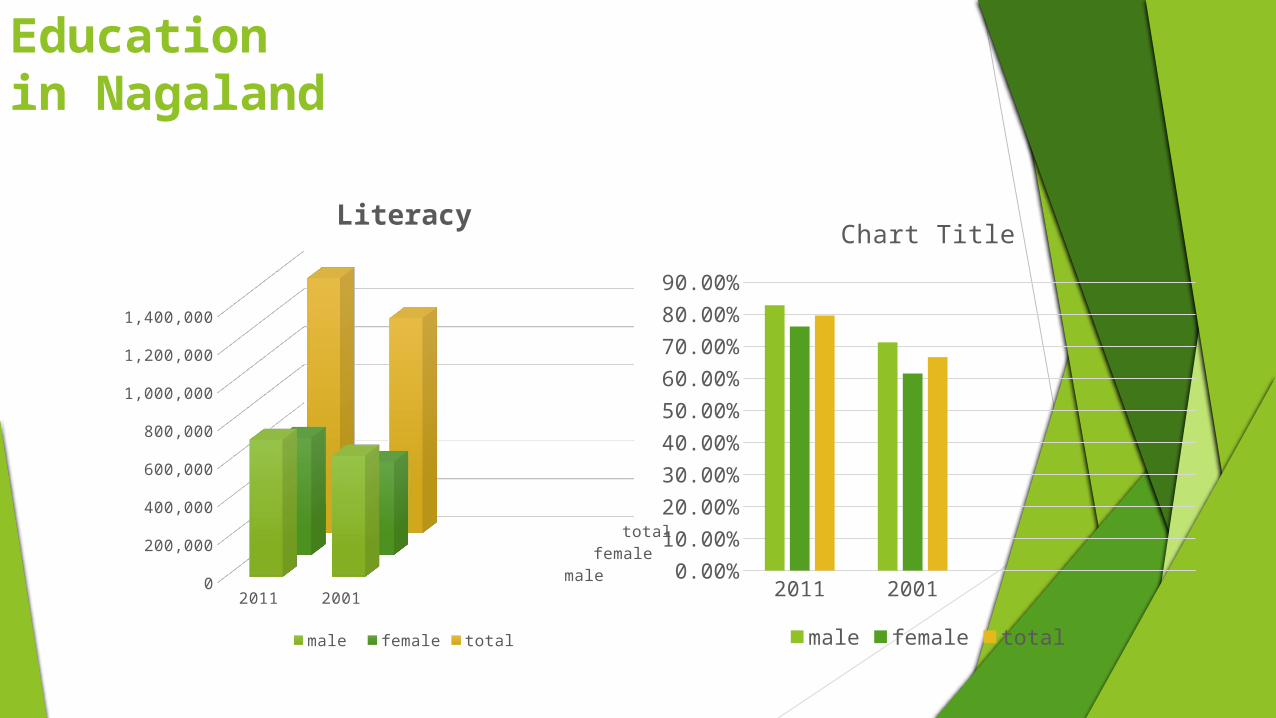
Literacy rate (%)* 80.1
Nagaland Factfile
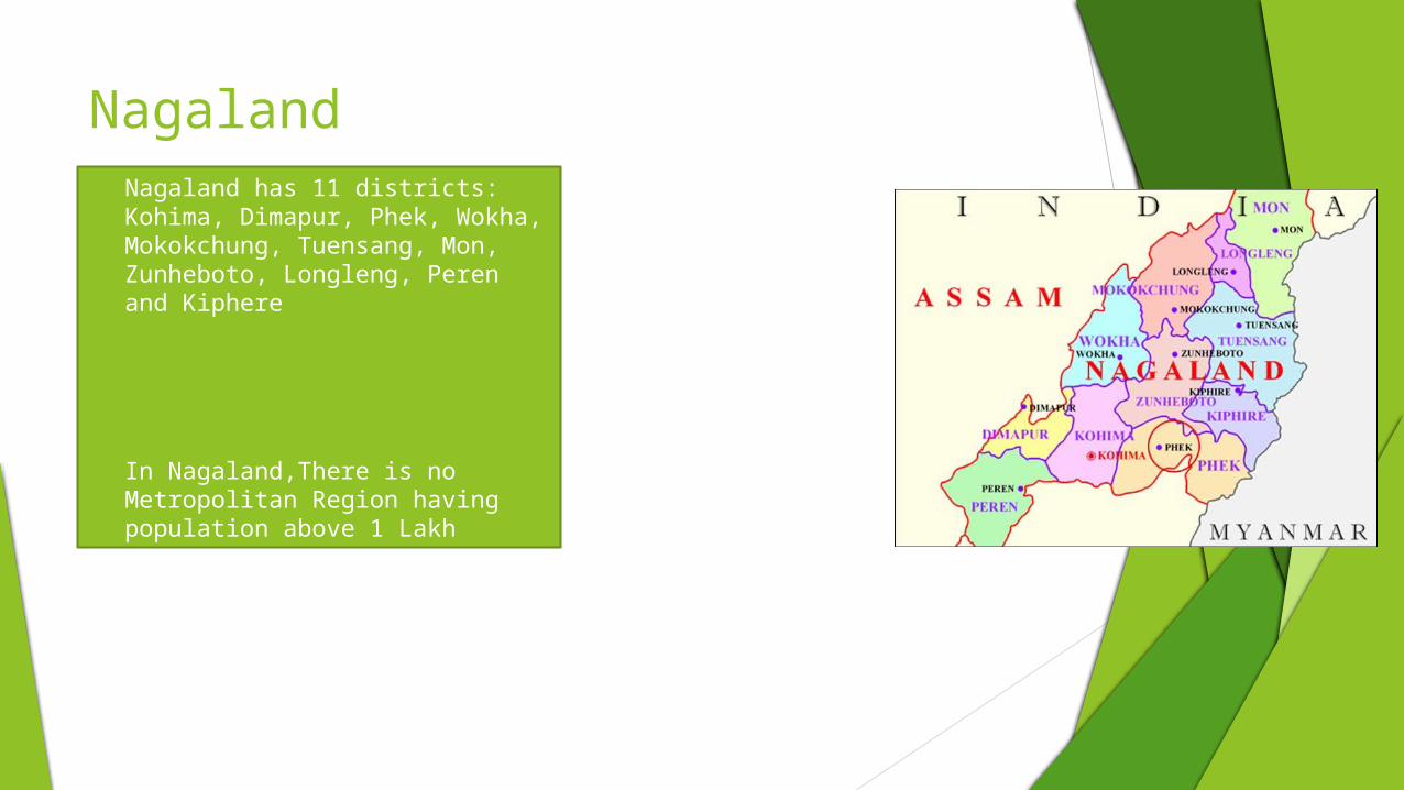
Nagaland Nagaland has 11 districts: Kohima,
Dimapur, Phek, Wokha, Mokokchung, Tuensang, Mon, Zunheboto, Longleng, Peren and Kiphere
In Nagaland,There is no Metropolitan Region having population above 1 Lakh

Geography of Nagaland
Nagaland is located on the extreme northern east just below Arunachal Pradesh. It has on its long eastern strip the
neighboring country Myanmar. The north is bounded by Arunachal Pradesh, while on its west lies the state of
Assam.Manipur borders it on its south.
Rains are heavy in Nagaland. The average rainfall is between 175 cm and 250 cm
The highest peak is Saramati in the Twensang district, which is 3840 meters above sea level.
The average height of the peaks is between 900 and 1200 metres
Big Cities Population Male FemaleDimapur (Municipal Committee)
122,834 64,300 58,534

Population in Nagaland
2011 20010
200,000
400,000
600,000
800,000
1,000,000
1,200,000
1,400,000
1,600,000
1,800,000
2,000,000
male female children (0-6 yrs)male children (0-6yrs) female children (0-6 yrs) total
Axis Title
popu
latio
n
Education in Nagaland
2011 20010
200,000
400,000
600,000
800,000
1,000,000
1,200,000
1,400,000
male female
total
Literacy
male female total
2011 20010.00%10.00%20.00%30.00%40.00%50.00%60.00%70.00%80.00%90.00%
Chart Title
male female total

The state offers excellent policy and fiscal incentives for agro-based and forest-based industries, horticulture, food processing, mining, tourism and the handlooms and handicrafts sector.
Policy and Fiscal Incentives
Nagaland has a high literacy rate of 80.1 per cent. Majority of the population in the state speaks English, which is the official language of the state. The state has strong focus on technical and medical education.
Availability of Skilled Labour
The state provides institutional support through various central and State Government agencies viz., North East Council, Ministry of Development of North Eastern Region and Nagaland Industrial Development Council.
Institutional Support
Advantage Nagaland

Advantage Nagaland … (2/2)
Nagaland’s agro-climatic conditions favour agriculture, horticulture and forestry, offering immense potential in these areas.
Conducive Agro-Climatic Conditions
The state has considerable resources of natural minerals, petroleum and hydropower.
Abundant Natural Resources
Transport and communication connectivity is good. Industrial Centres and Special Economic Zones (SEZs) are being developed to enhance the marketability of products.
Facilitating Infrastructure
2004-05
2005-06
2006-07
2007-08
2008-09
2009-10
2010-11
2011-12
0
400
800
1,200
1,600
2,000
2,400
2,800
1,298.91,487.7
1,602.6
2,006.72,055.32,166.8
2,440.42,516.5
Economic Snapshot – GSDP
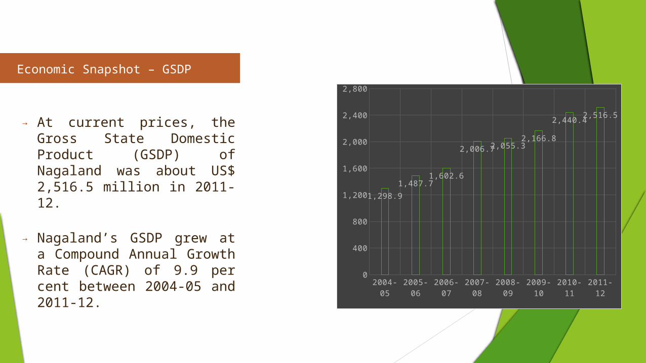
→ At current prices, the Gross State Domestic Product (GSDP) of Nagaland was about US$ 2,516.5 million in 2011-12.
→ Nagaland’s GSDP grew at a Compound Annual Growth Rate (CAGR) of 9.9 per cent between 2004-05 and 2011-12.

Rural v/s Urban
Nagaland State has total Area 16,579 square meters and over out of which 99% is rural area where as 1%
is urban.
rural urban
Out of total population of Nagaland, 28.86% people live in urban regions. The total figure of population living in urban areas is 570,966 of which 299,177 are males and while remain-ing 271,789 are females. The urban popula-
tion in the last 10 years has inc
rural urban

Out of total population of Nagaland, 28.86% people live in urban regions. The total figure of population living in urban areas is 570,966 of which 299,177 are males and while remaining 271,789 are females.
The urban population in the last 10 years has increased by 28.86 percent
Of the total population of Nagaland state, around 71.14 percent live in the villages of rural areas. In actual numbers, males and females were
725,472 and 682,064 respectively. Total population of rural areas of Nagaland state was 1,407,536. The population growth rate recorded
for this decade (2001-2011) was 71.14%
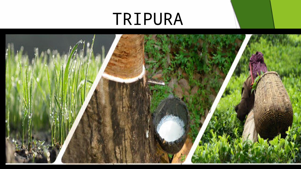
TRIPURA

→ Tripura is bounded on the North, West, South and South-east by Bangladesh, whereas in the East it has a common boundary with Assam and Mizoram.
→ Bengali and Kokborok/Tripuri are the official languages of the state. The medium of instruction in schools is either Bengali or English.
Parameters Tripura
Capital AgartalaGeographical area (sq km) 10,492Administrative districts (No) 4Population density (persons per sq km)* 350Total population (million)* 3.6
Male population (million)* 1.8 Female population (million)* 1.8
Sex ratio (females per 1,000 males)* 961Literacy rate (%)* 87.8
→ Tripura has four administrative districts: North Tripura, West Tripura, South Tripura and Dhalai. Agartala is the state capital and the state’s largest city. The key towns in the state are Kailashahar, Udaipur, Khumulwng, Kamalpur, Ambassa, Khowai and Sabroom.
→ The main rivers flowing through Tripura are Gomati, Manu, Khowai, Feni, Doloi, Muhuri and Haora.
Tripura
Tripura Factfile
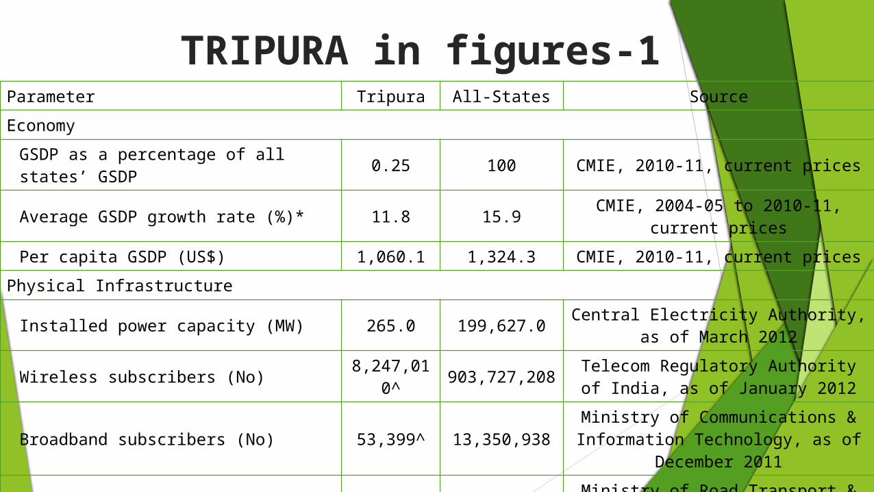
Parameter Tripura All-States SourceEconomy
GSDP as a percentage of all states’ GSDP 0.25 100 CMIE, 2010-11, current prices
Average GSDP growth rate (%)* 11.8 15.9 CMIE, 2004-05 to 2010-11, current prices
Per capita GSDP (US$) 1,060.1 1,324.3 CMIE, 2010-11, current pricesPhysical Infrastructure
Installed power capacity (MW) 265.0 199,627.0 Central Electricity Authority, as of March 2012
Wireless subscribers (No) 8,247,010^ 903,727,208 Telecom Regulatory Authority of
India, as of January 2012
Broadband subscribers (No) 53,399^ 13,350,938Ministry of Communications & Information Technology, as of
December 2011
National Highway length (km) 400 71,772 Ministry of Road Transport & Highways, Annual Report 2011-12
Airports (No) 1 133 Airport Authority of India
TRIPURA in figures-1
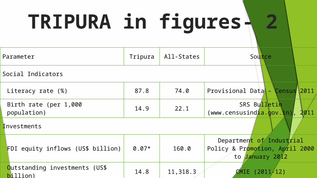
Parameter Tripura All-States Source
Social Indicators
Literacy rate (%) 87.8 74.0 Provisional Data – Census 2011
Birth rate (per 1,000 population) 14.9 22.1 SRS Bulletin (www.censusindia.gov.in), 2011
Investments
FDI equity inflows (US$ billion) 0.07* 160.0Department of Industrial Policy & Promotion, April 2000 to January
2012
Outstanding investments (US$ billion) 14.8 11,318.3 CMIE (2011-12)
TRIPURA in figures- 2

2004-052005-062006-072007-082008-092009-102010-112011-12
0 0.5 1 1.5 2 2.5 3 3.5 4 4.51.9
2.22.4
2.92.9
3.23.8
4.1
Series1 Linear (Series1)
Axis Title
Axis
Tit
le
GSDP
→At current prices, the total Gross State Domestic Product (GSDP) of Tripura was about US$ 4.1 billion in 2011-12.
→The state’s GSDP grew at an average annual rate of 11.6 per cent between 2004-05 and 2011-12.
TRIPURA

2004-05
2005-06
2006-07
2007-08
2008-09
2009-10
2010-11
2011-12
0 0.5 1 1.5 2 2.5 3 3.5 4
1.8
2.0
2.2
2.6
2.7
2.9
3.5
3.8
→ The Net State Domestic Product (NSDP) of Tripura was about US$ 3.8 billion in 2011-12.
→ Tripura’s NSDP grew at an average rate of 11.2 per cent between 2004-05 and 2011-12.
NSDP
TRIPURA
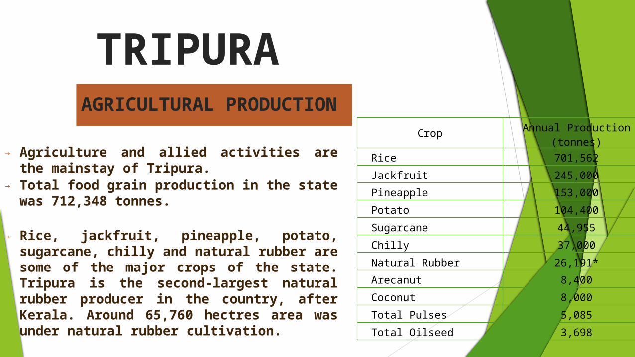
→ Agriculture and allied activities are the mainstay of Tripura.
→ Total food grain production in the state was 712,348 tonnes.
→ Rice, jackfruit, pineapple, potato, sugarcane, chilly and natural rubber are some of the major crops of the state. Tripura is the second-largest natural rubber producer in the country, after Kerala. Around 65,760 hectres area was under natural rubber cultivation.
→ The state has significant bio-diversity with 266 species of medicinal plants. A variety of horticultural and plantation crops are produced in Tripura. The major plantation crops in the state include coconut, arecanut, oil palm, cashew, tea, coffee and rubber.
Crop Annual Production (tonnes)
Rice 701,562Jackfruit 245,000Pineapple 153,000Potato 104,400Sugarcane 44,955Chilly 37,000Natural Rubber 26,191*Arecanut 8,400Coconut 8,000Total Pulses 5,085Total Oilseed 3,698
TRIPURAAGRICULTURAL PRODUCTION

→ Tripura had a total road length of 16,931 km.
→ The major towns are connected by National Highways that run through the state for about 400 km. NH-44 links Tripura with the rest of the Northeast.
→ The Tripura Road Transport Corporation (TRTC) provides state road transport services. TRTC operates 39 buses and 20 trucks on 32 routes.
Road Type Road Length (km)
Total Road Length 16,931National Highways 400State Highways 689Major District Roads 90Other District Roads 1,218Rural Roads 13,760
PHYSICAL INFRASTRUCTURE- ROADS

→ The railway route length in the state was around 151 km.
→ The major railway stations are located at Agartala, Dharmanagar and Kumarghat.
→ A 14 km metre-gauge railway line has been proposed between Akhaura (Bangladesh) and Agartala (Tripura). In addition, there is a proposed railway-link to be developed between Agartala and Sabroom, covering 110 km.
TRIPURAPHYSICAL INFRASTRUCTURE- RAILWAYS

→ Tripura has a domestic airport at Agartala, known as C.A. Agartala Airport. The airport is administered by the Airports Authority of India and is located 12 km southeast of Agartala city.
→ Domestic airlines operating from this airport are Jet Airways, Air India, Kingfisher, Spice Jet and Indigo Airlines with regular flights to destinations such as Guwahati, Kolkata, Silchar, Imphal, Delhi and Chennai.
→ The Agartala airport has also been upgraded, by extension of Airstrip and by providing night landing facilities.
Domestic Airport
TRIPURAPHYSICAL INFRASTRUCTURE- AIRPORT

→ Under the Jawaharlal Nehru National Urban Renewal Mission (JNNURM), two projects costing US$ 38.6 million has been sanctioned for Agartala. The projects are for water supply and sewerage in the North zone of the city.
→ The Asian Development Bank (ADB) has initiated a number of projects in Tripura in the areas of water supply, solid-waste management system, sewerage and sanitation.
→ Under the Urban Infrastructure Development Scheme for Small and Medium Towns (UIDSSMT), US$ 2.6 million has been allocated for development of storm drainage system in Ranirbazar and US$ 14.4 million has been allocated for development of roads in Belonia, Kailashahar and Kamalpur.
→ Ministry of Urban Development, Government of India has sanctioned “Construction of Town Hall at Sonamura Town” in Tripura with estimated investment of US$ 5 million.
TRIPURADEVELOPMENT PROJECTS: URBAN INFRASTRUCTURE

→ Tripura has a literacy rate of 87.8 per cent according to the provisional data of Census 2011; the male literacy rate is 92.2 per cent and the female literacy rate is 83.1 per cent. the state had 2,298 primary schools, 1,274 middle schools, 533 high schools and 350 higher-secondary schools.
→ The School Education Department of Tripura has given emphasis on achieving zero drop-out and 100 per cent retention in elementary level of schooling in Tripura through Sarva Shiksha Abhiyan (SSA) Scheme.
Tripura’s Education Statistics
Number of SchoolsPrimary: 2,298Middle: 1,274High: 533Higher Secondary: 350
Drop-Out Rate (%) Primary Stage: 4.05Elementary Stage: 9.68
Number of Teachers
Primary Schools: 7,855Middle Schools: 8,476High Schools: 8,584Higher Secondary Schools: 9,119
Literacy Rate (%)Literacy Rate 87.8Male Literacy 92.2Female Literacy 83.1
Source: Census (provisional data)
SOCIAL INFRASTUCTURE- EDUCATION-1

→ Tripura has a central university called Tripura University, a National Institute of Technology (NIT) and a state institute of technology called Tripura Institute of Technology (TIT).
→ Tripura has two universities, fifteen general colleges, two engineering colleges, two medical colleges, one agricultural college, one law college, eight industrial training institutes and three polytechnic institutes.
→ The State Government is taking several initiatives to encourage setting up of various educational complexes.
Educational InfrastructureUniversities 2General Colleges 15Engineering Colleges 2Medical Colleges 2Agricultural College 1Law College 1Industrial Training Institutes (ITI) 8
Polytechnic Institutes 3
Premier Institutions in Tripura• Maharaja Bir Bikram (MBB) College• National Institute of Technology• Tripura Institute of Technology• Tripura University
SOCIAL INFRASTUCTURE- EDUCATION-2
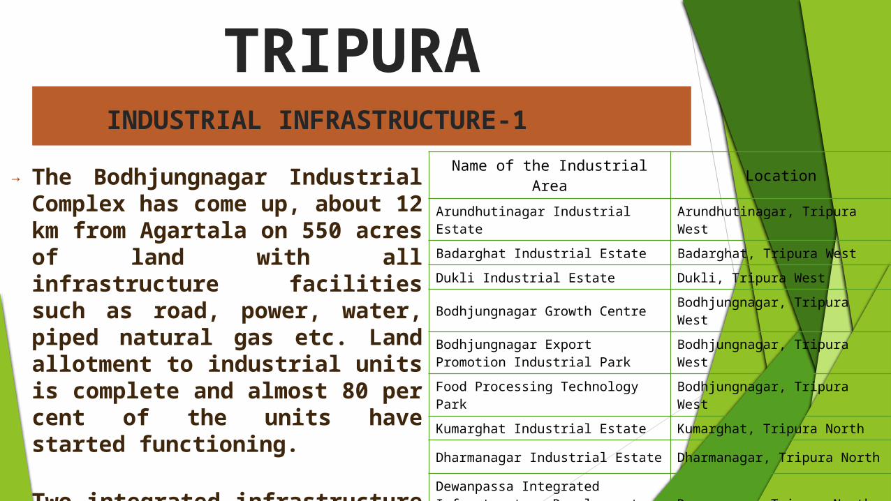
Name of the Industrial Area Location
Arundhutinagar Industrial Estate Arundhutinagar, Tripura West
Badarghat Industrial Estate Badarghat, Tripura WestDukli Industrial Estate Dukli, Tripura West
Bodhjungnagar Growth Centre Bodhjungnagar, Tripura West
Bodhjungnagar Export Promotion Industrial Park Bodhjungnagar, Tripura West
Food Processing Technology Park Bodhjungnagar, Tripura West
Kumarghat Industrial Estate Kumarghat, Tripura North
Dharmanagar Industrial Estate Dharmanagar, Tripura North
Dewanpassa Integrated Infrastructure Development Centre
Dewanpassa, Tripura North
Dhajnagar Industrial Estate Dhajnagar, Tripura South
→ The Bodhjungnagar Industrial Complex has come up, about 12 km from Agartala on 550 acres of land with all infrastructure facilities such as road, power, water, piped natural gas etc. Land allotment to industrial units is complete and almost 80 per cent of the units have started functioning.
→ Two integrated infrastructure development centres are being established in Tripura for which the site selection process is underway. The centres are coming up in the districts of South Tripura and Dhalai.
TRIPURAINDUSTRIAL INFRASTRUCTURE-1

Industrial Parks being Developed at Bodhjungnagar
NameProject
Cost (US$ million)
Land (acres
)Facilities
Rubber Park 4.79 58.8Internal and external road network, developed plot and shed, power and water supply, telecom, boundary wall, testing lab, sewage and drainage, security guard, etc.
Food Park 1.47 30Cold storage (1,500 metric tonnes), warehouse, quality control laboratory, sorting, grading and packaging unit, bottle manufacturing unit, test house.
Export Promotion Park 2.08 126.1Administrative block, internal and external road network, developed plot and shed, power and water supply, telecom, boundary wall, sewage and drainage, security guard, etc.
Bamboo Park 6.04 - Common facilities for bamboo based industries.
Source: Tripura Industrial Development Corporation Limited
TRIPURAINDUSTRIAL INFRASTRUCTURE-2

Key Industries in Tripura
• Natural Gas• Food Processinga• Rubber• Tea• Bamboo• Handloom and Handicrafts • Sericulture• Tourism• IT• Medicinal Plants
→ The resources, policy incentives, infrastructure and climate in the state support investments in sectors such as natural gas, food processing, rubber, tea, bamboo, handloom and handicrafts, sericulture, tourism, IT and medicinal plants.
→ Natural gas deposits are among the most important reserves of Tripura’s natural-resource base.
→ The other potential sectors of the state are organic spices, medicinal plants and bio-fuel. A state Bio-Fuel Mission has been implemented under the State Department of Forest, Tripura.
→ Favourable agro-climatic condition, low use of chemicals and availability of a variety of spices offer opportunities for development and procurement of the spices sector.
KEY INDUSTRIES

Assam

BASIC INFORMATION
Area of the state
30,285 sq mi (78,440 km2)
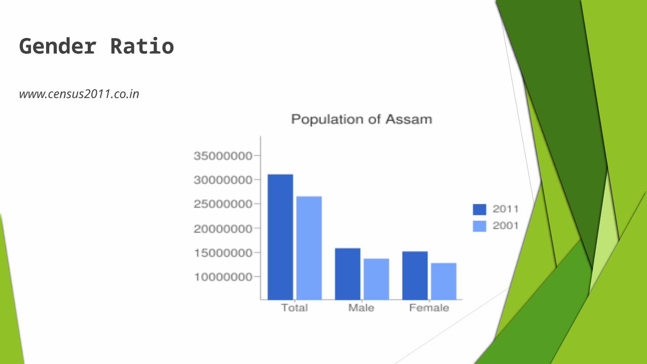
Population of Assam
As per 2011 census, total population of Assam was 31,205,576.

History of assam The notable rulers Ahoms and Kiratas. the earliest human communities that appeared in the land of Assam
were Australoids and Mongoloids. During the periods of 13th century, Assam was ruled by two prime
Dynasties of Kamarupa and Ahom. After the Ahom dynasty, Assam came under the control of Burmese
Kingdom.
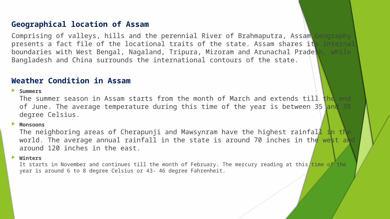
Geographical location of AssamComprising of valleys, hills and the perennial River of Brahmaputra, Assam Geography presents a fact file of the locational traits of the state. Assam shares its internal boundaries with West Bengal, Nagaland, Tripura, Mizoram and Arunachal Pradesh, while Bangladesh and China surrounds the international contours of the state.
Weather Condition in Assam Summers
The summer season in Assam starts from the month of March and extends till the end of June. The average temperature during this time of the year is between 35 and 38 degree Celsius.
MonsoonsThe neighboring areas of Cherapunji and Mawsynram have the highest rainfall in the world. The average annual rainfall in the state is around 70 inches in the west and around 120 inches in the east.
WintersIt starts in November and continues till the month of February. The mercury reading at this time of the year is around 6 to 8 degree Celsius or 43- 46 degree Fahrenheit.

Culture of assam The Culture of Assam is often referred to as hybrid culture.
It has developed by the gradual assimilation of cultures and traditions of various ethno-cultural groups.
A number of traditional festivals are celebrated in Assam , among them Bihu is the most important.

Unique features of Assam1. Assam has a State Anthem!2. Celebration of Cultures3. Assam has Three Different Types Bihu
Celebrations4. Guwahati — the pseudo-capital of Assam5. Jonbeel Mela6. All Kinds of Food Available Here!
Gender Ratio
www.census2011.co.in

Urban Rural RatioAround 86 per cent of Assam's population live in the countryside, whereas just 14 per cent live in urban areas, revealed in the 2011 census report.
86%
14%
Urban Rural Population
RuralUrban
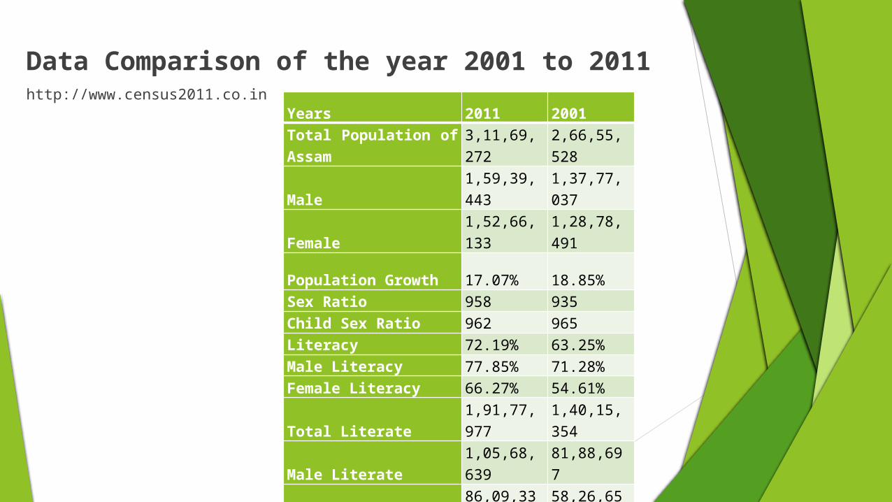
Data Comparison of the year 2001 to 2011http://www.census2011.co.in
Years 2011 2001Total Population of Assam
3,11,69,272
2,66,55,528
Male1,59,39,443
1,37,77,037
Female1,52,66,133
1,28,78,491
Population Growth 17.07% 18.85%Sex Ratio 958 935Child Sex Ratio 962 965Literacy 72.19% 63.25%Male Literacy 77.85% 71.28%Female Literacy 66.27% 54.61%
Total Literate1,91,77,977
1,40,15,354
Male Literate1,05,68,639 81,88,697
Female Literate 86,09,338 58,26,657

IMR and MMR
Assam’s infant mortality rate (IMR) is 58 compared to the national average of 47. The maternal mortality rate (MMR) of 390 is similarly much below the national average of 212.

Educational Sector in Assam
Educational Institutes Number
University 6Engineering Colleges 4Medical Colleges 3
S.No Institution Type Number Of Institutions1 Universities 32 Government Colleges 63 Non-Government Colleges 1894 Adhoc Colleges 275 Adhoc Law Colleges 76 Affiliated Colleges 117
7 Provincials Sanskrit and Law Colleges 78
8 Adhoc Sanskrit Colleges 16
9 Literary and Voluntary Organizations 12
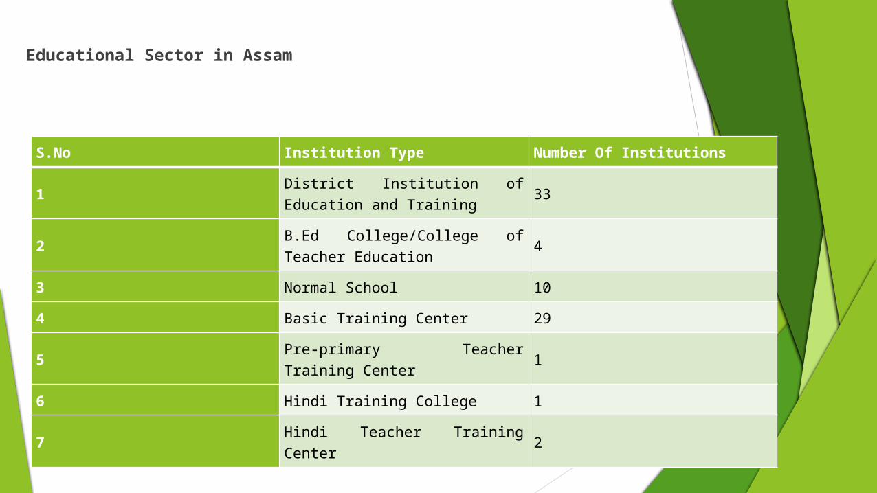
Educational Sector in Assam
S.No Institution Type Number Of Institutions
1 District Institution of Education and Training 33
2 B.Ed College/College of Teacher Education 4
3 Normal School 104 Basic Training Center 29
5 Pre-primary Teacher Training Center 1
6 Hindi Training College 17 Hindi Teacher Training Center 2

Industries in Assamwww.ibef.org

Economic Snapshot-GSDP
2006-07
2008-09
2010-11
2012-13
2014-15
$0.00 $5.00 $10.00$15.00$20.00$25.00$30.009.7
10.712.2
14.416.9
18.921.3
22.924
Assam’s GSDP
Series 1
US $ Billion
According to an official release, the Gross State Domestic Product (GSDP) at current prices has also increased to 14.85 per cent from 4.07 per cent in 2001-02
Ranked 19th, with SGDP of ₹1.59 lakh crore(US $24 Billion)

Growth rate (Ref - http://www.mapsofindia.com/maps/india/percapitaincome.htm) An economic growth rate is a measure of economic growth from one period to another in percentage terms. This measure does not adjust for inflation; it is expressed in nominal terms. In practice, it is a measure of the rate of change that a nation's gross domestic product (GDP) goes through from one year to another, but gross national product (GNP) can also be used if a nation's economy depends heavily on foreign earnings.
2007-08
2008-09
2009-10
2010-11
2011-12
2012-13
2013-14
05
101520253035 Seven Sisters Growth Rate Graph Arunachal Pradesh
Assam
Manipur
Meghalaya
Mizoram
Nagaland
Tripura
%Change
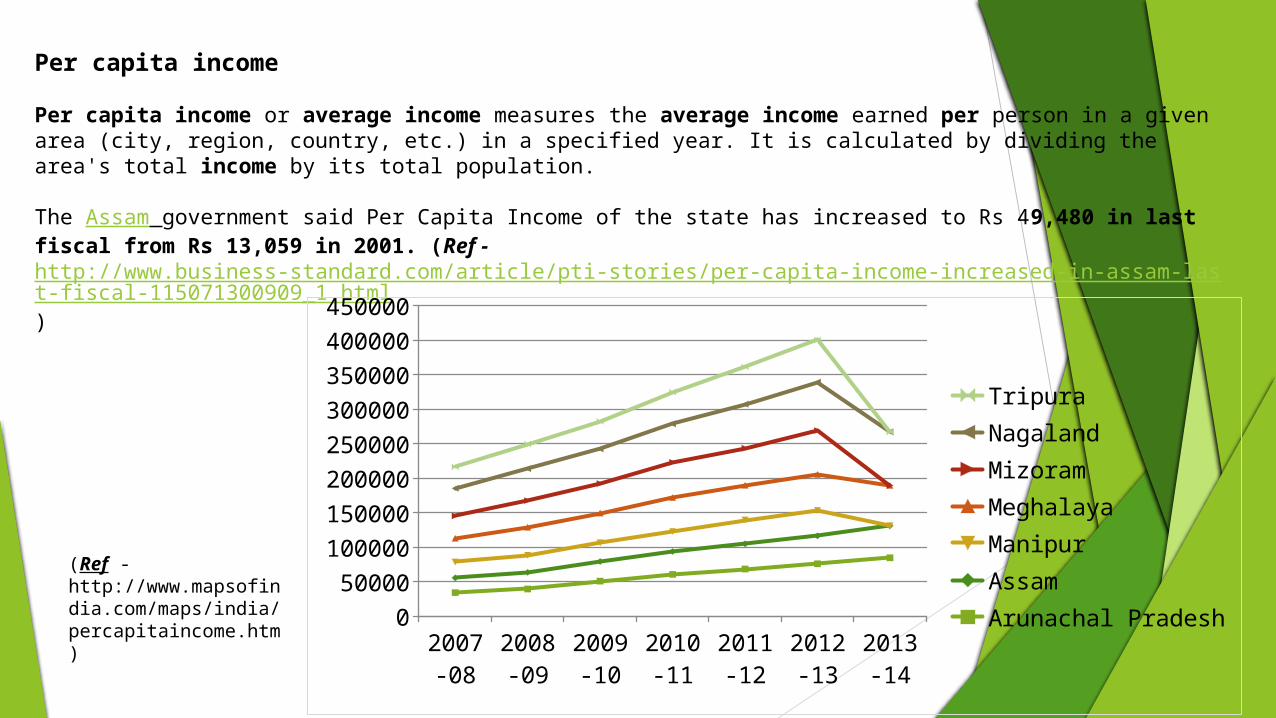
Per capita income
Per capita income or average income measures the average income earned per person in a given area (city, region, country, etc.) in a specified year. It is calculated by dividing the area's total income by its total population. The Assam government said Per Capita Income of the state has increased to Rs 49,480 in last fiscal from Rs 13,059 in 2001. (Ref - http://www.business-standard.com/article/pti-stories/per-capita-income-increased-in-assam-last-fiscal-115071300909_1.html)
2007-08
2008-09
2009-10
2010-11
2011-12
2012-13
2013-14
050000
100000150000200000250000300000350000400000450000
TripuraNagalandMizoramMeghalayaManipurAssamArunachal Pradesh
(Ref - http://www.mapsofindia.com/maps/india/percapitaincome.htm)
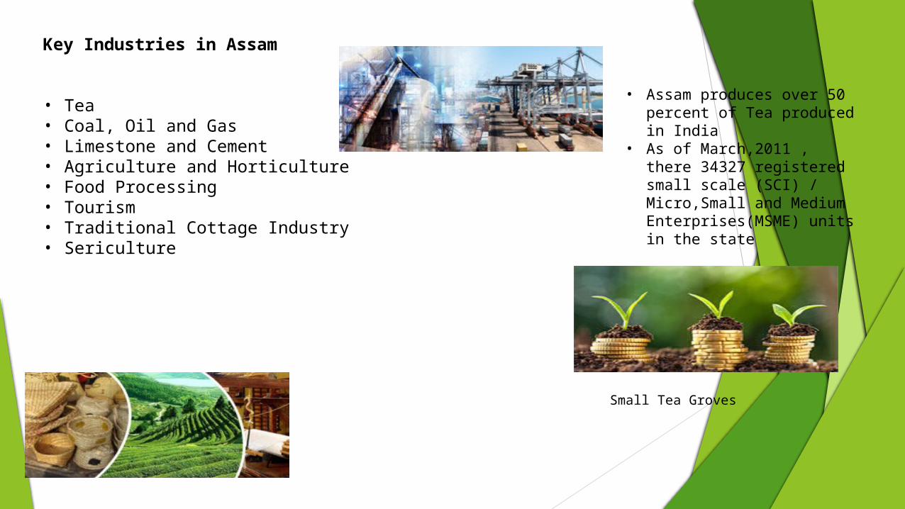
Key Industries in Assam
• Tea• Coal, Oil and Gas• Limestone and Cement• Agriculture and Horticulture• Food Processing• Tourism• Traditional Cottage Industry• Sericulture
• Assam produces over 50 percent of Tea produced in India
• As of March,2011 , there 34327 registered small scale (SCI) / Micro,Small and Medium Enterprises(MSME) units in the state
Small Tea Groves
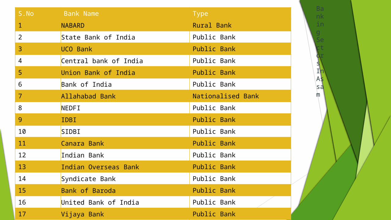
S.No Bank Name Type1 NABARD Rural Bank2 State Bank of India Public Bank3 UCO Bank Public Bank4 Central bank of India Public Bank5 Union Bank of India Public Bank6 Bank of India Public Bank7 Allahabad Bank Nationalised Bank8 NEDFI Public Bank9 IDBI Public Bank10 SIDBI Public Bank11 Canara Bank Public Bank12 Indian Bank Public Bank13 Indian Overseas Bank Public Bank14 Syndicate Bank Public Bank15 Bank of Baroda Public Bank16 United Bank of India Public Bank17 Vijaya Bank Public Bank18 Andhra Bank Nationalised Bank
Banking Sectors In Assam

Retail Sector • Many shopping malls and large format retail outlets • Malls such as Sohum Shoppe, HUB, Dona Planet and The Cube• Vishal Megamart opened its first store in Guwahati • Titan Industries also has its retail presence with watch showrooms in
Guwahati.• Future Group too made its presence felt in Guwahati, opened its first
75000 sq. ft Big Bazaar outlet in April 2007 and 30000 sq. ft Pantaloons outlet in the same year in Guwahati.
• Another 24000 sq. ft Big Bazaar outlet came in January 2009.

Tourism
AHMEDABAD, MAY 28(AS IN NEWSPAPER): • Assam looks to double its tourist arrivals from 46 lakh tourists in 2014-15 to about 90 lakh tourists over the next two years.• The state, known for its tea gardens and Kaziranga rhinoceros’ sanctuary, has earmarked about Rs. 15 crore for promotion of
tourism in the state to attract more tourists.
“We get maximum tourists from Gujarat and West Bengal. Therefore we are beginning our roadshow from Ahmedabad to promote Assam Tourism.About 12 per cent of the total tourists are from Gujarat,” said Ashutosh Agnihotri, commissioner & secretary, tourism department, Government of Assam.
• About 25,000 foreign tourists visited Assam last fiscal.

Wildlife reserves like
- Kaziranga National Park
- Manas National Park
- Pobitora Wildlife Sanctuary
- Nameri National Park
- Dibru-Saikhowa National Park
It has a rich cultural heritage going back to the Ahom Dynasty which governed the region for many centuries before the British occupation.

BASIC INFORMATION
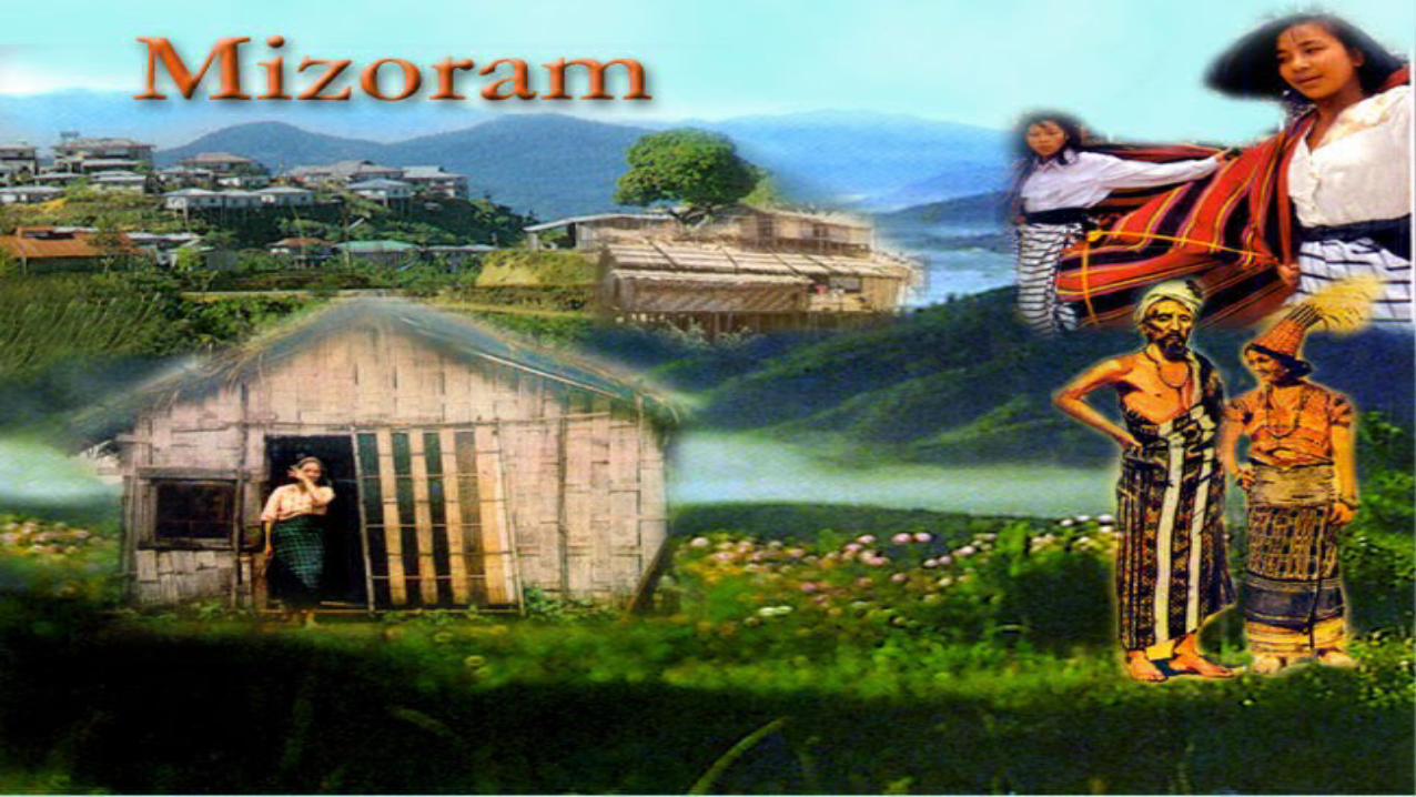
Mizoram is one of the states of Northeast India, with Aizawl as its capital city. The name is derived from Mi (people), Zo (lofty place, such as a hill) and Ram (land), and thus Mizoram implies "land of the hill people“. In the northeast, it is the southern most landlocked state sharing borders with three of the Seven, now with the addition of Sikkim,Eight sister states, namely Tripura, Assam, Manipur. The state also shares a 722 kilometre border with the neighbouring countries of Bangladesh and Myanmar.Like several other northeastern states of India, Mizoram was previously part of Assam until 1972, when it was carved out as a Union Territory. It became the 23rd state of India, a step above Union Territory, on 20 February 1987
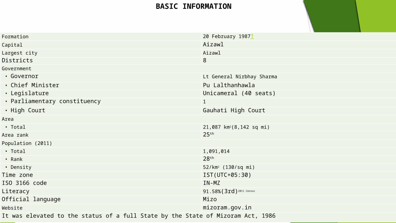
Formation 20 February 1987†Capital AizawlLargest city AizawlDistricts 8Government • Governor Lt General Nirbhay Sharma • Chief Minister Pu Lalthanhawla • Legislature Unicameral (40 seats) • Parliamentary constituency 1 • High Court Gauhati High CourtArea • Total 21,087 km2(8,142 sq mi)Area rank 25th
Population (2011) • Total 1,091,014 • Rank 28th
• Density 52/km2 (130/sq mi)Time zone IST(UTC+05:30)ISO 3166 code IN-MZLiteracy 91.58%(3rd)2011 Census
Official language MizoWebsite mizoram.gov.inIt was elevated to the status of a full State by the State of Mizoram Act, 1986
BASIC INFORMATION

Social Indicators Gender Ratio
• The density of population of Mizoram is 52 persons per sq.km. while it is 382 persons per
sq.km. in India. • Aizawl district has the highest density in population at 112 persons per sq.km., Mamit
district with 29 persons per sq.km. is the least populated. • The final results of Population Census 2011 shows an improvement in the sex ratio of the
state i.e. the sex ratio recorded is 976 as compared to 935 in 2001 census. • The national figure for the same is 943 as per 2011 census figure.• Among the 8 (eight) districts, Aizawl recorded the highest sex ratio at 1009 while Mamit
district recorded the lowest at 927 females per 1000 males.
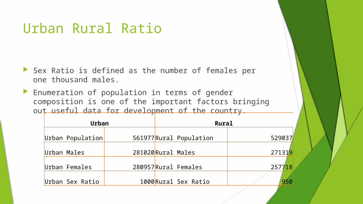
Urban Rural Ratio
Sex Ratio is defined as the number of females per one thousand males. Enumeration of population in terms of gender composition is one of the
important factors bringing out useful data for development of the country.
Urban Rural
Urban Population 561977 Rural Population 529037
Urban Males 281020 Rural Males 271319
Urban Females 280957 Rural Females 257718
Urban Sex Ratio 1000 Rural Sex Ratio 950

Literacy ratio
As per the census 2011 results, the literacy rate of the state is 91.33% which is the 3rd highest in the country.
The male and female literacy rates for the state are 93.35% and 86.72% respectively showing a slight increase in the male-female literacy gap i.e. 6.63% in 2011 while it was 3.97% in 2001.
1951 1961 1971 1981 1991 2001 20110
102030405060708090
100
Male & Female Literacy Rate From 1951-2011
MaleFemale

IMR(Infant Mortality Rate)
Infant mortality refers to deaths of young children, typically those less than one year of age. It is measured by the infant mortality rate (IMR), which is the number of deaths of children under one year of age per 1000 live births.
The Infant Mortality Rate (IMR) in Mizoram during the past six months (April to September) was 36 and Maternal Mortality Rate (MMR) 121, health department officials said today.
There were 13 maternal deaths and 387 infant deaths (below one year) during the period.

Demographic pattern
There are presently 8 Districts in Mizoram. The Total population of the Mizoram is 1.1 Million.
As per Districts Census 2011, the most populated district in Mizoram is Aizawl with a population of 400,309 where as the least populated district is Saiha with a population of 56,574.
As per The 2011 census of Mizoram Districts, Serchhip is the highest literate district with 98% of literacy rate where as Lawngtlaiis the least literate district with a literacy rate of 66%.
The census 2011 of Mizoram Districts also shows that Aizawl District represents the highest sex ratio with 1009 females per 1000 males while Mammit District features the lowest sex ratio in India with just 927 women per 1000 males
Composition Of Sectors
Sectoral Overview (Industrial sector):
Industrialization in Mizoram is rather slow owing to absence of many pre-requisite factors for industrial development. Even though the geographical location and topography of the state is not congenial for industrial development the sector has slowly made a significant contribution in the GSDP. The industries sector has contributed 22.02% of GSDP during 2012-13 as against 18.66% in 2011-12 (Statistical handbook Mizoram 2014).

Composition Of Sectors
Industrial Infrastructure:
The State Government with its limited resources and geographical disadvantages had earmarked and developed industrial areas with basic infrastructure. These industrial areas, though not fully provided with required infrastructure, will solve the problem of industrial land for entrepreneurs desirous of starting Industrial unit to a great extent. Allotment of industrial plots in various industrial areas has been made as per the Mizoram Industrial Areas (Management, Regulation and Control) Act.-2008. Upgradation of EPIP Lengte is being executed under the funding from NEC.

Composition Of Sectors
Textiles, Handlooms & Handicrafts:
Handloom is the most flourishing sector in the development of Industrial activities. The handloom production is estimated to be 6.00 crore creating thousands of employment. The sector is further expected to be most promising to benefit the Look East Policy announced by the Central Government. Handloom Sector is most potential sector for export as the inhabitants of the South East Asian Countries are wearing the same type of fabrics produced by local weavers.

Composition Of Sectors
Food Processing Sector:
Development of Food Processing Industry has been taken up under the National Mission on Food Processing (NMFP). The Director of Industries has been appointed as Mission Director for the State Mission on Food Processing. Funding pattern for the NE States under the Scheme is 90:10 Government of India has released Rs. 1.125 crores for preparatory works for launching the scheme Rs. 2.21 crores has been sanctioned for Mizoram for implementation of the 4 (four) components of the Scheme. The first meeting of the SLEC on 26/11/2013 had decided to implement the scheme in a society mode. For this society by the name of Mizoram Food Processing Development Society (MIFPRODS) has been formed and is being registered under the Societies Registration Act.
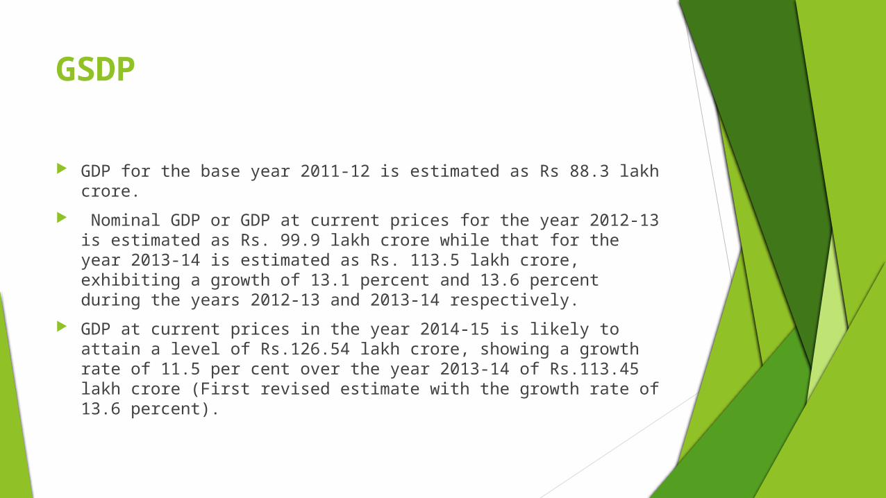
GSDP
GDP for the base year 2011-12 is estimated as Rs 88.3 lakh crore. Nominal GDP or GDP at current prices for the year 2012-13 is
estimated as Rs. 99.9 lakh crore while that for the year 2013-14 is estimated as Rs. 113.5 lakh crore, exhibiting a growth of 13.1 percent and 13.6 percent during the years 2012-13 and 2013-14 respectively.
GDP at current prices in the year 2014-15 is likely to attain a level of Rs.126.54 lakh crore, showing a growth rate of 11.5 per cent over the year 2013-14 of Rs.113.45 lakh crore (First revised estimate with the growth rate of 13.6 percent).

GSDP
The growth in GDP during 2014-15 is estimated at 7.4 per cent as compared to the growth rate of 6.9 per cent in 2013-14
Growth Rate
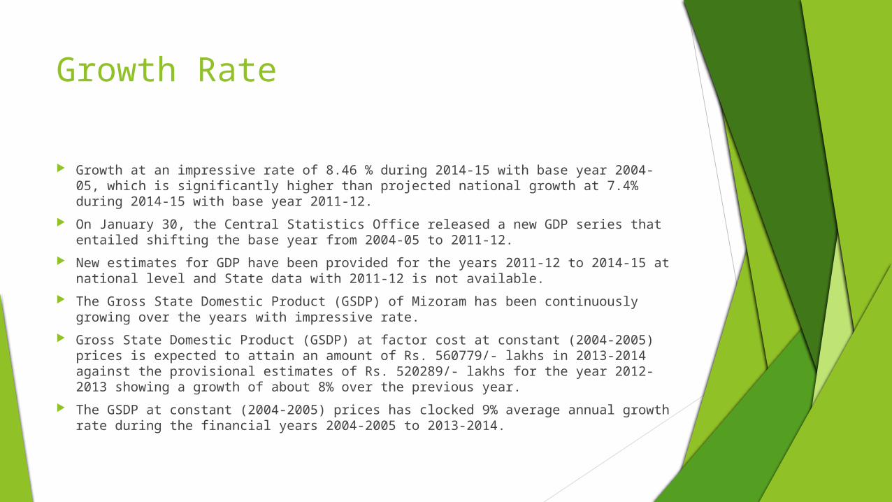
Growth at an impressive rate of 8.46 % during 2014-15 with base year 2004-05, which is significantly higher than projected national growth at 7.4% during 2014-15 with base year 2011-12.
On January 30, the Central Statistics Office released a new GDP series that entailed shifting the base year from 2004-05 to 2011-12.
New estimates for GDP have been provided for the years 2011-12 to 2014-15 at national level and State data with 2011-12 is not available.
The Gross State Domestic Product (GSDP) of Mizoram has been continuously growing over the years with impressive rate.
Gross State Domestic Product (GSDP) at factor cost at constant (2004-2005) prices is expected to attain an amount of Rs. 560779/- lakhs in 2013-2014 against the provisional estimates of Rs. 520289/- lakhs for the year 2012-2013 showing a growth of about 8% over the previous year.
The GSDP at constant (2004-2005) prices has clocked 9% average annual growth rate during the financial years 2004-2005 to 2013-2014.

Per capita income
The per capita income in real terms (at 2011-12 prices) during 2014-15 is likely to attain a level of `74,193 as compared to `69,959 for the year 2013-14.
The growth rate in per capita income is estimated at 6.1 per cent during 2014-15, as against the previous year's estimate of 5.4 per cent.
Provisional per capita income during 2012-2013 is Rs. 63413.00 as against previous year‘s estimate of Rs.53624.

Per Capita Income
Year Per Capita Income (in Rs.)
2008-2009 38582
2009-2010 42715
2010-2011 50956
2011-2012 53624
2012-2013(P) 63413
2013-2014(Pr) 76120
The per capita income of Mizoram for the year 2012-2013 is estimated at Rs.63413/- as against the previous year‘s estimate of Rs.53624/-.

State Finances
Fiscal Position The Thirteenth Finance Commission recommended that Govt. of Mizoram
will have to maintain Revenue Surplus from the fiscal 2011-12, gradually reduce its fiscal deficit to 5.2 per cent in 2012-13, 4.1 per cent in 2013-14 and ultimately to 3 per cent of its GSDP by 2014-15 and limit outstanding liabilities at 82.9 per cent of GSDP in 2012-13, 79.2 per cent in 2013-14 and eventually at 74.8 per cent of corresponding GSDP by 2014-15.
State’s Share in Central Taxes As per the recommendation of the Thirteenth Finance Commission, the
share of States in the net proceeds of Union taxes was fixed at 32 per cent. Out of this, the share of Mizoram in inter-se distribution of the State‘s share amongst the States is 0.269 per cent.

State Finances
State’s Own Tax Revenues The SOTR has a positive trend of growth, it was Rs. 130.44 crore in
2010-11, Rs. 179.07 crore in 2011-2012, Rs. 223.15 crore in 2012-13 and Rs.229.78 crore in 2013-14
State’s Own Non tax Revenues The SONTR has increased from Rs.146.72 crore in 2010-11 to Rs.
168.03 crore in 2011-12, which further increased to Rs.212.80 crore in 2012-13 and finally declined to Rs. 194.26. Hence the trend growth rate was erratic showing that various Departments needed to put more efforts in SONTR.

Industrial Infrastructure
State Enterprises for Development of Various Trades
• Mizoram Agriculture Marketing Corporation • Mizoram Food and Allied Industries Corporation • Mizoram Khadi and Village Industries Board• Zoram Energy Development Agency • Zoram Handloom & Handicrafts Development Corporation • Zoram Industrial Development Corporation
→ Mizoram has five industrial estates at Zuangtui, Sailamkawn, Cahmphai Hmunhmeltha, Bairabi and Pukpui Lunglei.
→ Zoram Industrial Development Corporation (ZIDCO) is responsible for the overall development of industrial infrastructure in the state.
→ ZIDCO has established an Integrated Infrastructure Development Centre (IIDC) at Lunglei district with an investment of around US$ 1.0 million. The centre offers power, water, telecommunication and other amenities for the industrial units.
→ The government has acquired 127 acres of land in Khawnuam for development of the Indo-Myanmar border trade township.
→ A border trade centre has been established for trade with Bangladesh.
Industrial Units (As of March 2010)
Registered SSI Units 7,888
Handicraft Training Centres 8
Handloom Training Centres 3
Mizoram

Key Industries
Key Industries in Mizoram
• Bamboo • Energy• Sericulture• Agriculture and Horticulture• Tourism• Food Processing• IT• Handloom and Handicrafts• Minerals and Stones• Medicinal Plants
→ The natural resources, climatic conditions and policy incentives in the state support investments in bamboo, sericulture, tourism, agro-products and agro-processing sectors.
→ Industrial units in the state primarily comprise of small scale industries. As of March 2010, there were 7,888 registered small scale industrial units in Mizoram.
→ Mizoram is setting up an Special Economic Zone (SEZ) in the Northeast with assistance from the North East Council. The SEZ will be located at Khawnuam village in Champhai. Bamboo-based industries would play a major role in the proposed SEZ.
→ During 2009-10, more than 450 small scale industrial units were registered in the state.
Mizoram

→ With its highly green hills, crisscrossing rivers, and interspersed lakes, Mizoram is a tourist’s paradise.
→ The number of domestic tourists arrival has been increasing consistently. The number of domestic tourists arrival increased from 56,651 in 2009 to 57,292 in 2010.
→ Creation of tourist complexes, adventure sports and resort facilities, amusement parks, health farms, hotels, convention centres, tourist travel services, etc., offer various avenues for investment in the tourism sector of Mizoram.
→ There are 39 tourist lodges in the state.
Mizoram
Key Industries – Tourism
Number of Domestic Tourists Arrival (In ‘000)
Source: Ministry of Tourism, Government of India
2008 2009 20100
10
20
30
40
50
60
70
56.0 56.6 57.2

→ Mulberry, muga, eri, oak-tasar and silk are cultivated in Mizoram.
→ As of March 2010, about 7,293 families in 175 villages were engaged in sericulture. There were 17 farms across 5,100 ha.
→ The State Government had established one research & training institute at Zemabawk to impart training in sericulture.
Name Production – 2009-10(Metric Tonnes)
Mulberry 60
Muga 1.2
Eri 4.2
Oak tasar 0.2
Silk yarn 6.5
Mizoram
Key Industries – Sericulture

POSTAL SERVICE
The status and achievements of Postal Services in Mizoram Division during 2014-15 is given below: —
1. Number of Post Offices in Mizoram Division
Head Post Office - 1
Sub-Post Offices - 38
Branch Post Offices - 350
Total - 389
2. Revenue Collection (i.e. up to 10th February, 2015)
Postal Life Insurance - Rs. 2,88,10,119.00
Rural Postal Life Insurance - Rs. 1,04,45,424.00
Total - Rs. 3,92,55,543.00

Postal Service
3. Sale of Postage Stamps - Rs. 74,99,036.30 4. Savings Bank Target - Rs. 8,00,00,000.00 5. Achievement - Rs. 3,96,00,000.00 6. Business Development - Rs. 1,97,60,920.30

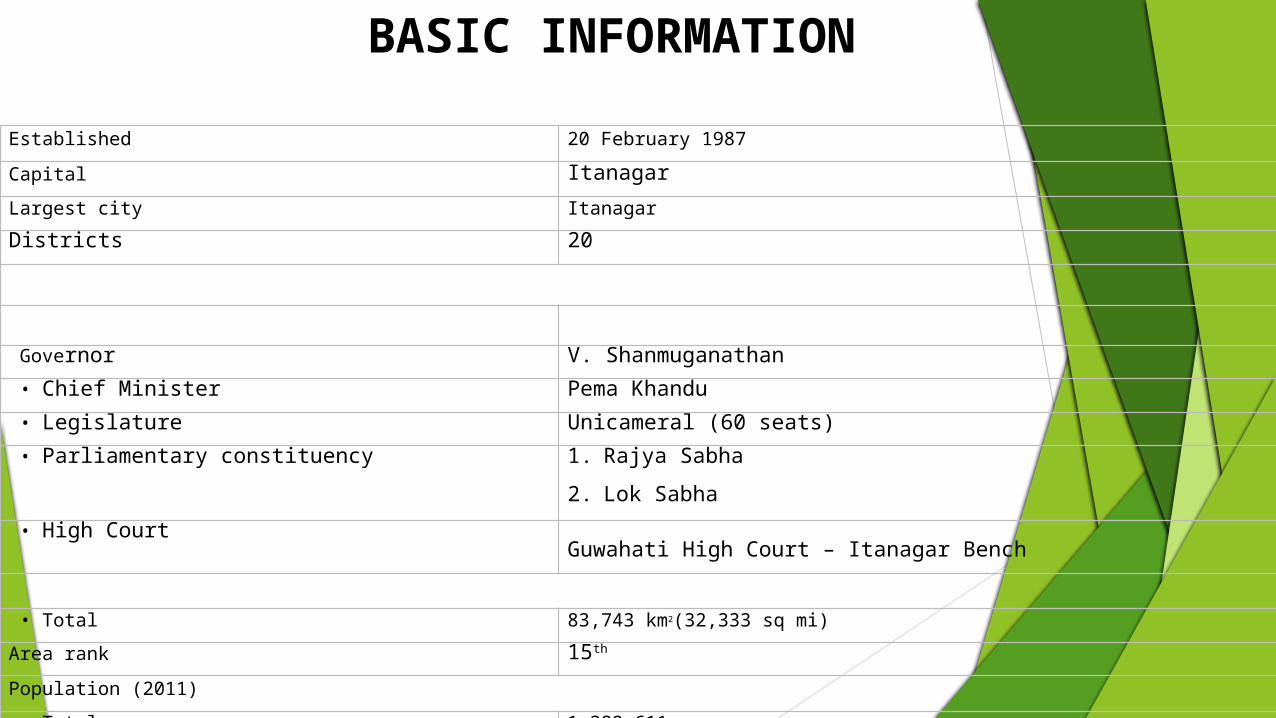
BASIC INFORMATIONEstablished 20 February 1987Capital ItanagarLargest city ItanagarDistricts 20
Governor V. Shanmuganathan • Chief Minister Pema Khandu • Legislature Unicameral (60 seats) • Parliamentary constituency 1. Rajya Sabha
2. Lok Sabha • High Court
Guwahati High Court – Itanagar Bench
• Total 83,743 km2(32,333 sq mi)Area rank 15th
Population (2011) • Total 1,382,611

BASIC INFORMATION
Rank 27th
Density 17/km2 (43/sq m)
Time zone IST (UTC+05:30)ISO 3166 code IN-ARHDI 0.617 (medium)
HDI rank 18th (2005)
Literacy 66.95%
Official language English
Website arunachalpradesh.nic.in
BASIC INFORMATION
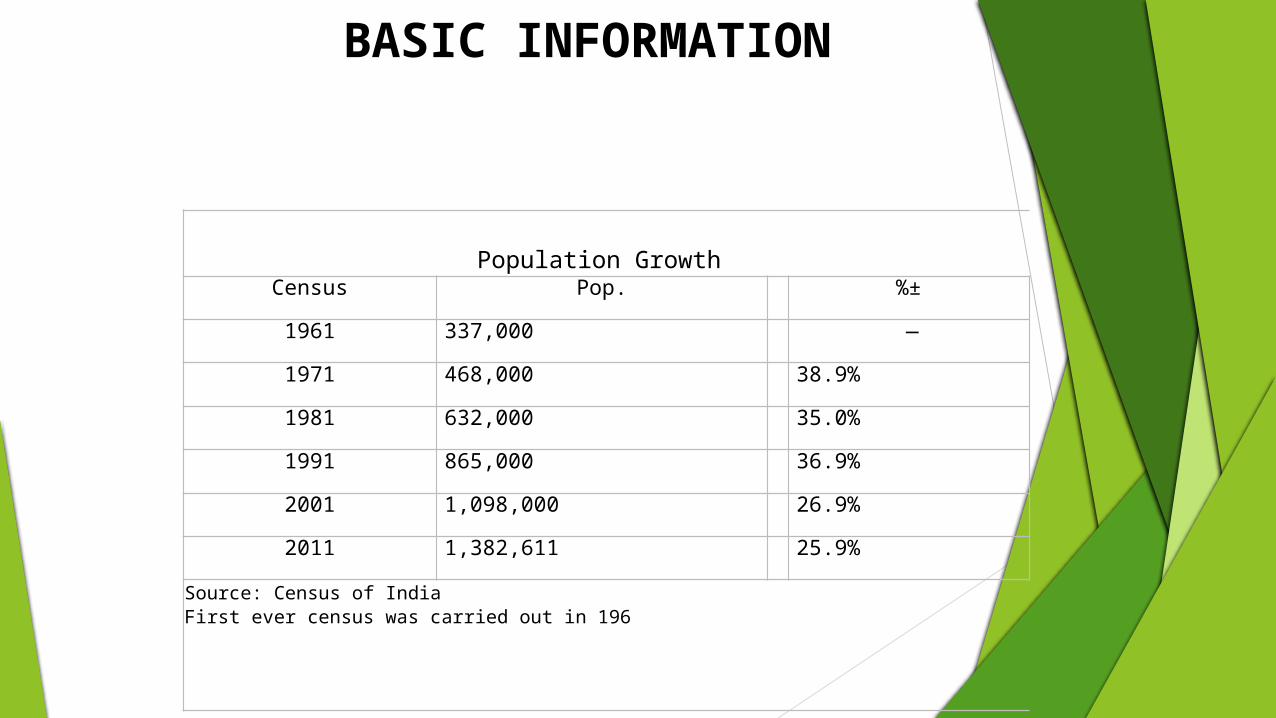
Population Growth Census Pop. %±1961 337,000 —1971 468,000 38.9%1981 632,000 35.0%1991 865,000 36.9%2001 1,098,000 26.9%2011 1,382,611 25.9%
Source: Census of IndiaFirst ever census was carried out in 196

Geography Arunachal Pradesh is located between 26.28° N and 29.30° N latitude and 91.20° E and 97.30° E
longitude and has 83,743 square kilometre area. Most of Arunachal Pradesh is covered by the Himalayas.
Climate The climate of Arunachal Pradesh varies with elevation. Areas that are at a very high elevation in the
Upper Himalaya close to the Tibetan border have an alpine or tundra climate. Arunachal Pradesh receives heavy rainfall of 2,000 to 4,100 millimetres (79 to 161 in) annually, most
of it between May and September. The mountain slopes and hills are covered with alpine, temperate, and subtropical forests of dwarf rhododendron, oak, pine, maple, fir, and juniper; sal (Shorea robusta) and teak are the main economically valuable species.
BASIC INFORMATION

SOCIAL INDICATORSDescription 2015 2001Approximate Population 13.84 Lakhs 10.98 Lakh
Actual Population 1,383,727 1,097,968Male 713,912 579,941Female 669,815 518,027Population Growth 26.03% 26.21%Percantage of total Population 0.11% 0.11%
Sex Ratio 938 893Child Sex Ratio 972 964Density/km2 17 13Density/mi2 43 34Area(Km2) 83,743 83,743Area mi2 32,333 32,333Total Child Population (0-6 Age) 212,188 205,871
Male Population (0-6 Age) 107,624 104,833
Female Population (0-6 Age) 104,564 101,038
Literacy 65.38 % 54.34 %Male Literacy 72.55 % 63.83 %Female Literacy 57.70 % 43.53 %Total Literate 766,005 484,785Male Literate 439,868 303,281Female Literate 326,137 181,504

SOCIAL INDICATORS

Universities of Arunachal Pradesh
University Location Type Established Specialization WebsiteIndira Gandhi Technological and Medical Sciences University
ZiroTechnical and medical university - unitary
May 2012 Medical, Engineering, Paramedical Sciences, Management,Agriculture http://www.igtamsu.ac.in
North East Frontier Technical University Aalo Technical university March 2014 Engineering, Paramedical Sciences,
Management, Arts & Science http://www.neftu.edu.in
Arunachal University of Studies Namsai State-affiliating
university 2012
Agriculture, Humanities & Social Science, Commerce, Law, Management, Engineering, Fine Arts, Music, Vocational and Skill Development
http://www.arunachaluniversity.ac.in
Venkateshwara Open University Itanagar
Private open university - non-affiliating
2012 Open learning http://www.vou.ac.in
Apex Professional University Pasighat Professional
university - affiliating 2013 Professional courses http://www.apexuniversity.ac.in
Himalayan University Itanagar State private - non-affiliating 2013 All courses http://www.himalayanuniversity.com
Rajiv Gandhi University Itanagar Central - affiliating 1984 General http://www.rgu.ac.inNorth Eastern Regional Institute of Science and Technology
Nirjuli Deemed - non-affiliating 1986 (2005) Technology, Science, Management http://www.nerist.ac.in
Central Institute of Himalayan Cultural Studies
Tenga Valley, West Kameng District, Arunachal Pradesh
Affiliated to Sanskrit University Varanasi, funded by Ministry of Culture, Government of India
Universities

ECONOMIC PROFILE
Year
Gross Domestic Product
(Billion INR)
1980 1.070
1985 2.690
1990 5.080
1995 11.840
2000 17.830
2005 31.880
2010 65.210
2014 155.880
The chart below displays the trend of the gross state domestic product of Arunachal Pradesh at market prices by the Ministry of Statistics and Programme Implementation with figures in billions of Indian Rupees.
Arunachal Pradesh's gross state domestic product was estimated at US$706 million at current prices in 2004 and US$1.75 billion at current prices in 2012.
Agriculture primarily drives the economy. Jhum, the local term used for shifting cultivation is being widely practiced among the tribal groups, though owing to the gradual growth of other sources of income in the recent years. Arunachal Pradesh has close to 61,000 square kilometers of forests, and forest products are the next most significant sector of the economy. Among the crops grown here are rice, maize, millet, wheat, pulses, sugarcane, ginger, and oilseeds. Arunachal is also ideal for horticulture and fruit orchards.
Its major industries are rice mills, fruit preservation and processing units, and handloom handicrafts. Sawmills and plywood trades are prohibited under law.
Arunachal Pradesh accounts for a large percentage share of India's untapped hydroelectric potential. In 2008, the government of Arunachal Pradesh signed numerous memorandum of understanding with various companies planning some 42 hydroelectric schemes that will produce electricity in excess of 27,000 MW. Construction of the Upper Siang Hydroelectric Project, which is expected to generate between 10,000 and 12,000 MW, began in April 2009.

ECONOMIC PROFILE
GSDP of Arunachal PradeshArunachal Pradesh's gross state domestic product (GSDP) was US$ 2.57 billion over 2014-15.
: NSDP of Arunachal PradeshArunachal Pradesh's net state domestic product (NSDP) was US$ 2.07 billion over 2014-15.

Government schemes

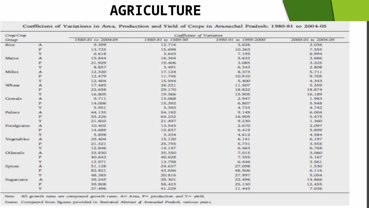
AGRICULTURE
Some major crops of Arunachal Pradesh are paddy, millet, wheat, pulses, potatoes, sugarcane, oilseeds, and maize.
The agriculture in Arunachal Pradesh also comprise of production of few endemic vegetables such as sweet potatoes, brinjal, ginger, chillies, pumpkin, cucumber, and local cow pea.
Fruit cultivation is also practiced in the agricultural sector of Arunachal Pradesh. The fruits that are cultivated include pineapple, apple, oranges, lemon, lichi, papaya, banana, plum, guava, cherries, peach walnut, and almond. Rice is the chief food crop in Arunachal Pradesh.
AGRICULTURE

AGRICULTURE

INDUSTRY

INDUSTRY
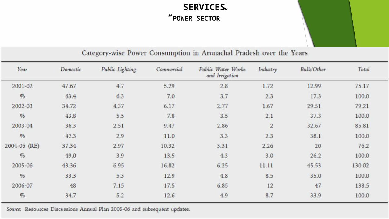
SERVICES “POWER SECTOR”

tourism
Arunachal Pradesh has an enormous potential for tourism and the tourists can enjoy its picturesque hills, dales and seasonal climate, and meet its people with their beautiful arts, crafts and colourful festivals
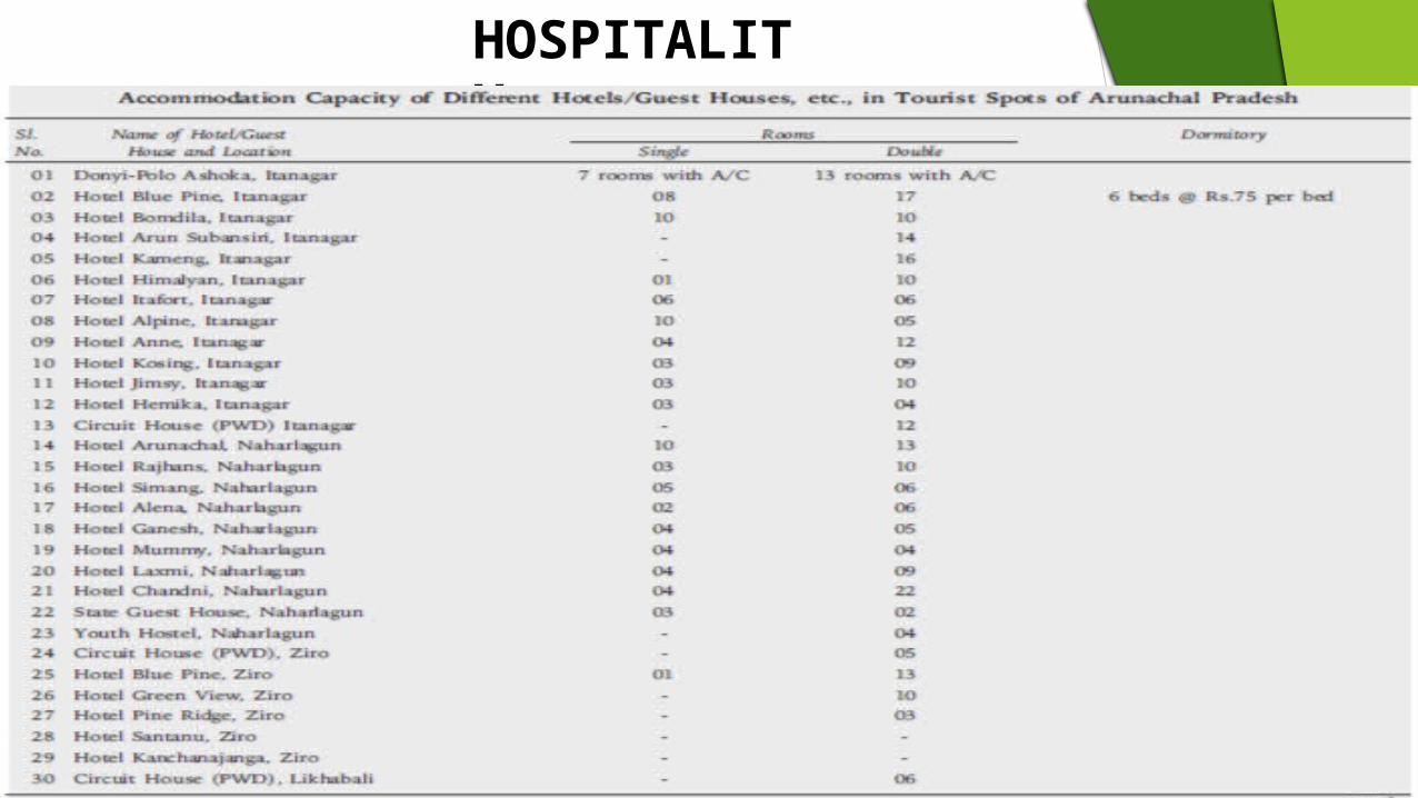
HOSPITALITY

MEGHALAYA

Meghalaya : - Half Way To Heaven Area of state: - 22,429
Sq.Kms. Population: - 3.211 million
(2014).
Source: - http://www.census2011.co.in/census/state/meghalaya.html#statecart2

Rural and Urban Divide
Rural Population: - 79.93% Urban Population: - 20.07%
79.93%
20.07%
Population
Rural Population Urban Population
Source: - http://www.census2011.co.in/census/state/meghalaya.html#statecart2

History Of Meghalaya
Meghalaya or megh- cloud; alay- home; is a picturesque but tiny state in the northeastern region of India.
As is the name, the state receives heavy rainfall and two of the world’s wettest places are located in Meghalaya.
Full of vibrant culture, tradition, great scenic beauty, and tranquility are some of the attractions of the state that can pull any tourist in.
The region was accorded full statehood on January 21, 1972.

Geographical Location
Meghalaya is located in the northeast region of India, and extends latitude 20�1’’N-26�5’’N and longitude 85�49’’E-92�52’’E.
It extends for about 300 km in length and about 100 km in width. The landscape of Meghalaya is mostly rolling plateau with south-
facing slopes being extremely steep. With the hill rising to 2,000 m, the state is cool despite its proximity to tropics. The state abounds in lakes and waterfalls.
Around 30% of total land in Meghalaya is under forest cover. Different parts of many plants growing in Meghalaya have been put
to medicinal use.

Culture
The people of Meghalaya are famous for their weaving skills and creating cane mats, stools, and baskets.
They make a special kind of cane mat called tlieng, which guarantees a good utility of around 20-30 years.
The Khasis have also been involved in extracting iron ore and manufacturing domestic knives, utensils and even guns and other warfare weapons.
Weather
Source: - (AccuWeather, 2016)

Unique Features
The people of Meghalaya are cheerful, sociable and hardworking and have exemplary dignity of labour.
Men are married into the women's families. They come to live in their wife’s home and the children bear the surnames of their mothers.
Social Indicators
Meghalaya people can be classified into three main groups i.e., Garos, Khasis, and Jaintias. The Garos inhabit in the western side of the Meghalaya, Khasis reside in the central region while Jaintias can be traced down in the eastern part of Meghalaya. The Khasi and Jaintia tribes have the traits of Proto Austroloid Monkhmer race whereas the Garos have come from Bodo family of the Tibeto-Burmar race.
The Khasis along with the Pnars form a group named Khasi-Pnar. The Khasis can be traced down in the Khasi hills whereas Pnars are mainly located in Jaintia hills. Collectively, Jaintia, War, Khasi and Bhoi people are known as Hynniewtrep

Gender Ratio
Sex Ratio in Meghalaya is 989 i.e. for each 1000 male, which is below national average of 940 as per census 2011. In 2001, the sex ratio of female was 972 per 1000 males in Meghalaya. (Census2011.co.in, 2016).
(Mapsofindia.com, 2016)

Literacy ratio
The following table shows the literacy rate from 1971-2001.

Demographic pattern (Age group category)
http://censusindia.gov.in
Age groups-wise Population of Districts of Meghalaya, Census, 20001.

Education Sector.Sr no School/colleges
1 Govt. Boys' HSS 2 Govt. Girls' HSS3 Sohkha Govt. HSS 4 Dadengiri Govt. HSS 5 Ampati Govt. Girls' HSS 6 Tura Govt. College 7 Kiang Nangbah Govt.
College8 Sohra Govt. College 9 Captain W.A. Sangma Govt.
College 10 Williamnagar Govt. College
Contribution of Agriculture, Manufacturing and Services Meghalaya is basically an agrarian state, in which about 80 per cent
of the population depend primarily on agriculture for their livelihood. The State has a vast potential for developing horticulture due to agro-climatic variations, which offer much scope for cultivation of temperate, sub-tropical and tropical fruits and vegetables.
The share of the industrial sector for all eight states has increased while the share of agriculture and allied activities has declined. (IndiaSpend, 2016).

Economic Profile
Meghalaya is predominantly an agrarian economy. The contribution of this sector to the State's NSDP is only about one-
third. Meghalaya's gross state domestic product for 2012 was estimated at
₹16,173 crore (US$2.4 billion) in current prices. As of 2012, according to the Reserve Bank of India, about 12% of
total state population is below poverty line, with 12.5% of the rural Meghalaya population is below the poverty line; while in urban areas, 9.3% are below the poverty line.

SGDP Meghalaya’s growth in GSDP of 9.7% was equivalent to Bihar, which had a GSDP growth rate of 9.1%.The share of the industrial sector for all eight states has increased while the share of agriculture and allied activities has declined.Meghalaya had India’s second-lowest unemployment rate (after Gujarat), with 0.4% in rural areas and 2.8% in urban areas in 2011-12.

Investments "Building on the positive momentum achieved, my government will further upscale
investment in the domain of sports to achieve higher visibility and meaningful outcome," Shanmuganathan said while addressing the Budget session of the state assembly. (The Times of India, 2016).
The North-East Industry and Investment promotion Policy (NEIIPP) was formulated nearly a decade ago. Meghalaya government ask improvement in investment policy, new features, especially excise duty and income tax waive. (Indiatoday.intoday.in, 2016).
Chief minister said looking at ethanol as bio-feul from bamboos in north east region, which is rich in bamboo cultivation, can help a lot the objective of lowering crude oil imports. This can be done with an investment of only around Rs 1000 crore. (Indiatoday.intoday.in, 2016).
Projects Kynshi stage 1 and kynshi stage 2, the Meghalaya government has finally decided to hand
over two 450 Mw each hydel power projects to private companies for execution. Rs 7000 crore is expected from Athena Power and jaypee Group. (Dey, 2016).
The Union Ministry of Environment, Forests and Climate Change has cleared five projects related to climate change including one in Meghalaya worth over a hundred crore rupees, official sources said on Tuesday. (Studio, 2016).
The project sanctioned for Meghalaya – Spring-shed development works for rejuvenation of springs for climate resilient development in the water stressed areas – will cost Rs 23.98 crore and will seek to maintain and improve the integrity of the natural water bodies of the State. (Studio, 2016).
The project interventions will help in reducing the surface runoff of rainwater in the spring-shed areas, promote deeper water percolation, and rejuvenate the water table. The project is expected to benefit approximately 16,494 households, sources said. (Studio, 2016).
Make in India and Swatch Bharat
‘Make in Northeast’ initiative, inspired by Prime Minister Narendra Modi’s ‘Make in India’ concept, would in the long run “seek to promote exclusive Northeast expertise in areas like tea processing, organic farming, food processing, exploitation of wind power through wind mills, AYUSH, wellness therapies like spas.” (Studio, 2015)One of the important objectives of “Make in Northeast” initiative, Singh said, will be not only to generate revenue for Northeast but also to create job opportunities to prevent the exodus of youth which is presently taking place from the region to the rest of the country. (Studio, 2015).On the first anniversary of the Swatch Bharat Abhiyan, Governor V Shanmuganathan and Home Minister Roshan Warjri among others wielded the broom as they called upon people to resolve to make Meghalaya the cleanest State in the country. (Theshillongtimes.com, 2015).
Agriculture
Meghalaya produced 230,000 tonnes of food grains in 2001. Rice is the dominant food grain crop accounting for over 80% of the food grain production in the state. Other important food grain crops are maize, wheat and a few other cereals and pulses. Besides these, potato, ginger, turmeric, black pepper, areca nut, tezpatta, betelvine, short-staple cotton, jute, mesta, mustard and rapeseed etc. are some of the important cash crops. Besides the major food crops of rice and maize, the state is renowned for its horticultural crops like orange, lemon, pineapple, guava, litchi, banana, jack fruits and fruits such as plum, pear and peach

Agriculture
Oilseeds such as rapeseed, mustard, linseed, soybean, castor and sesame are grown on nearly 100 km2 (39 sq mi). Rape and mustard are the most important oilseeds[41] accounting for well over two-thirds of the oilseed production of nearly 6.5 thousand tonnes. Fibre crops such as cotton, jute and mesta are among the only cash crops in Meghalaya, grown in Garo Hills.
Areca nut plantations can be seen all over the state, especially around the road from Guwahati to Shillong. Other plantation crops like tea, coffee and cashews have been introduced lately and are becoming popular. A large variety of spices, flowers, medicinal plants and mushrooms are grown in the state.
Industries
Major industries : - 1. Agro based industries: - The potential for Agro-based industries in the state of Meghalaya is
very high. Meghalaya's turmeric, particularly the variety that is grown in Shangpung in the Jaintia Hills, is considered the best in the world and its curcumine content is as high as 7.5%.
2. Mineral based industries: - There are extensive deposits of coal, limestone, granite, clay and other minerals. Coal deposits are available in all districts and particularly in the southern slopes of the state. The coal bears a low ash content and its calorific value ranges between 6500 to 7500 K.Cal/Kg. The total estimated reserve of coal is in the region of 640 million tonnes. The coal is mainly of sub-bituminous type and can be utilised in varied industries ranging from power, fertilizer, cement and textile to paper, rubber, brick burning and also pottery based industries. The coal that is found in the State can also be converted into coke to recover value added chemicals like light, medium and heavy oil, phenol and producer gas.Granite of excellent quality is at present being mined in the East and West districts of Khasi hills. Sizeable deposits are estimated and can be found in various shades and colours.other economically viable minerals like gypsum, phosphorite, glass-sand, base metals, quartz and feldspar can be located in various parts of the state. The State is also credited with having one of the most valuable sillimanite deposits in the world.

Services
Number of commercial banks

Total deposits (domestic /NRI), loans. Banks per number of people

Tourism
Famous place to visit Shillong,cherrapunji, tura, mawsynram, jowai,mawlynnong,dawki,
umiam lake, etc.
JEWEL OF INDIA

Manipur is situated in the eastern-most corner of Northeast India. The state shares borders with other north-eastern states of Nagaland, Mizoram and Assam and the neighbouring country of Myanmar.
The Manipur river basin has eight major rivers: the Manipur, Imphal, Iril, Nambul, Sekmai, Chakpi, Thoubal andKhuga.
There are 9 districts Manipuri dance also known as Jagoi, is one of the major Indian
classical dance forms,[67] named after the state of Manipur.It is particularly known for its Hindu Vaishnavism themes,

EXCUTIVE SUMMAMARY
Manipur Is One Of India’s Largest Bamboo Producing States And A Major Contributor To The Country’s Bamboo Industry. In 2015, The State Accounted For 9,303 Square Kilometre Of Bamboo Bearing Area.
Manipur Has The Highest Number Of Handicrafts Units As Well As The Highest Number Of Craft Persons Comprising Skilled And Semi-skilled Artisans In The Entire North-eastern Region.
Handlooms Is The Largest Cottage Industry In Manipur And The State Ranks Among The Top Five In Terms Of The Number Of Looms In The Country.
Manipur Has The Advantage Of Acting As India’s ‘Gateway To The East’ Through Moreh Town, Which Isthe Only Feasible Land Route For Trade Between India And Myanmar And Other Southeast Asian Countries.
The Ema Bazaar Is One Of India’s Largest Markets Run By Women. This Market Majorly Sells Handloom And Handicraft Products Such As Earthen Pots, Knives, Shawls And Puppets; As Well As All Kinds Of Dried Fish And Vegetables.
Due To Its Wealth Of Flora And Fauna, Manipur Is Described As A ‘Flower On Lofty Heights’, ‘A Jewel Of India’ And ‘Switzerland Of The East’. Its Breathtakingly Scenic Beauty Makes It A Tourist’s Paradise.
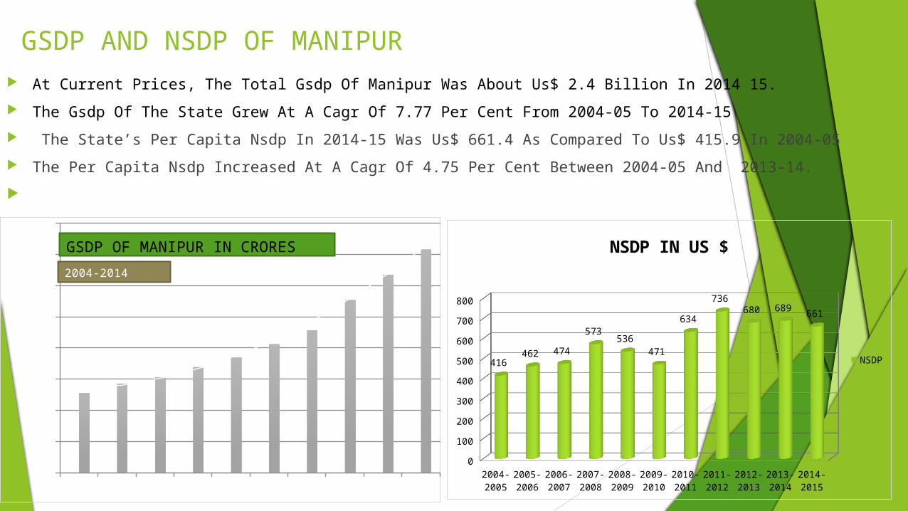
GSDP AND NSDP OF MANIPUR At Current Prices, The Total Gsdp Of Manipur Was About Us$ 2.4 Billion In 2014 15.
The Gsdp Of The State Grew At A Cagr Of 7.77 Per Cent From 2004-05 To 2014-15
The State’s Per Capita Nsdp In 2014-15 Was Us$ 661.4 As Compared To Us$ 415.9 In 2004-05
The Per Capita Nsdp Increased At A Cagr Of 4.75 Per Cent Between 2004-05 And 2013-14.
10
2000
4000
6000
8000
10000
12000
14000
16000
51335718 6137
6783
82549137
11084
12697
14324GSDP OF MANIPUR IN CRORES2004-2014
2004-2005
2005-2006
2006-2007
2007-2008
2008-2009
2009-2010
2010-2011
2011-2012
2012-2013
2013-2014
2014-2015
0
100
200
300
400
500
600
700
800
416462 474
573536
471
634
736680 689 661
NSDP IN US $
NSDP

POPULATION OF MANIPUR
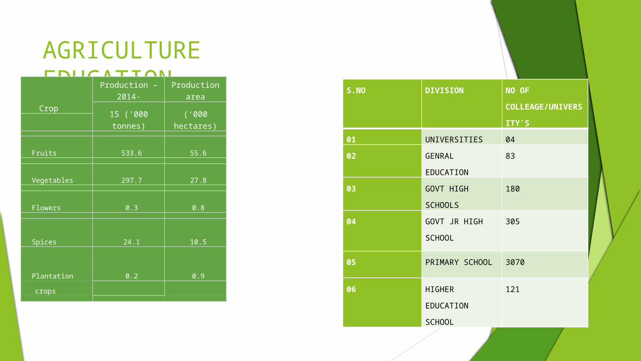
AGRICULTURE EDUCATION
Crop
Production – 2014-
Production area
15 (‘000 tonnes) (‘000 hectares)
Fruits 533.6 55.6
Vegetables 297.7 27.8
Flowers 0.3 0.8
Spices 24.1 10.5
Plantation 0.2 0.9
crops
S.NO DIVISION NO OF COLLEAGE/UNIVERSITY`S
01 UNIVERSITIES 0402 GENRAL
EDUCATION83
03 GOVT HIGH SCHOOLS
180
04 GOVT JR HIGH SCHOOL
305
05 PRIMARY SCHOOL 3070
06 HIGHER EDUCATION SCHOOL
121
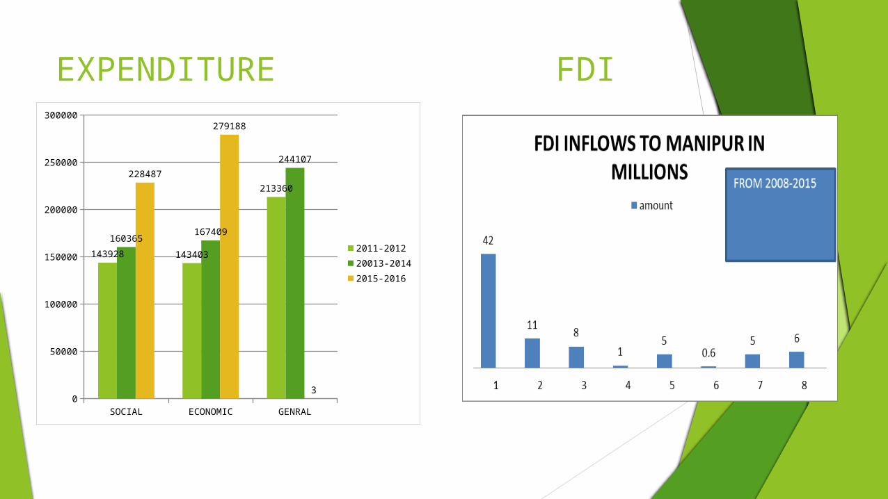
EXPENDITUREFDI
SOCIAL ECONOMIC GENRAL0
50000
100000
150000
200000
250000
300000
143928 143403
213360
160365 167409
244107228487
279188
3
2011-201220013-20142015-2016

TOURISUM LOKTAK LAKE
Loktak Lake Is The Largest Freshwater Lake In Northeast India, And Is Famous For The Phumdis (Heterogeneous Mass Of Vegetation, Soil, And Organic Matter At Various Stages Of Decomposition) Floating Over It
KANGLA FORT
On 20th November 2004, The Kangla Fort Was Handed Over By The Indian Prime Minister Manmohan Singh To The State Government Of Manipur. At Present, The Fort Is Open For Visitors And Is A Major Tourist Attraction
WAR CEMETERY
Commonwealth War Graves Commission Maintains The Graveyard. Little Stone Markers With Bronze Plaques On Them Commemorate The Dead British And Indian Soldiers Of World War II.

POSTAL SERVICESManipur Postal Division Covers The State Of Manipur. As Per The Census 2011, The State Has A Population Of 27.22 Lakhs With An Overall Literacy Rate Of 79.85%. The Percentage Of Rural Population In The State Is 69.79%. Manipur Postal Division Covers 1 Head Post Office In The State Capital Of Imphal And 53 Departmental Sub Post Offices Spread Across The State And 643 Numbers Of Branch Post Offices HospitalityMedical facilities in the state were mainly provided by the state Government. Medical and Health care facilities were available to the people of Manipur through a network of 55hospitals/dispensaries with a total manpower of 888(2005-06) doctors and 1,055 (2005-06) nurses, midwives and Dias. The number of beds available was 1609 in 2010-11. Out of 1193.3 thousands patients treated in 2014-15, 65.3 thousands were indoor patients while 1128.0 thousands were outdoor patients. The health infrastructure comprises seven district hospitals, 85 primary health centres (PHCs), 421 primary health sub-centres (PHSCs), 16 community health centres and 30dispensaries.

BANKS
S.NO BANK/SECTOR BRANCHES PRIVATE SECTOR01 HDFC BANK 0502 ICICI BANK 0503 AXIS BANK 09
PUBLIC SECTOR
04 STATE BANK OF INDIA 3405 IDBI BANK 01 NATIONALISED BANKS06 ALLAHABAF BANK 0307 BANK OF BARODA 1508 BANK OF MAHARASTRA 0109 CANARA BANK 0410 INDIAN OVERSES BANK 0211 PUNJAB NATIONAL BANK 0512 UCO BANK 1213 VIJAYA BANK 0514 PUNJAB AND SIND BANK 0215 UNITED BANK OF INDIA 2016 CENTRAL BANK OF INDIA 1217 UNION BANK OF INDIA 0118 SYNDICATE BANK 01
REGIONAL RURAL BANKManipur rural bank 01

Thank You For Your Patience