Embed Size (px)
DESCRIPTION
Citation preview

How can GIS help thePetroleum Industry?
Stine Skinnes, Technical Advisor (e-mail: [email protected])
Explore DevelopAppraise MarketRefineTransportProduce Decommission
Adding Value Across The Industry Lifecycle

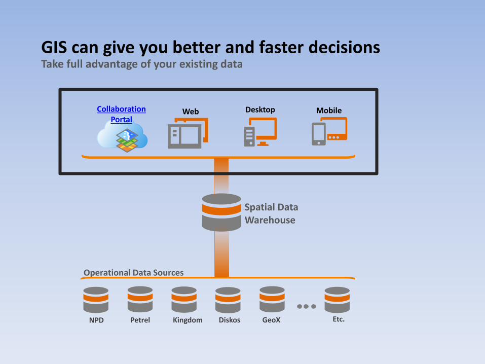
GIS can give you better and faster decisions
MobileDesktopWeb
Spatial Data Warehouse
Operational Data Sources
NPD Petrel Kingdom Diskos GeoX Etc.
Collaboration Portal
Take full advantage of your existing data

GIS can give you better and faster decisions
MobileDesktopWeb
Spatial Data Warehouse
Operational Data Sources
NPD Petrel Kingdom Diskos GeoX Etc.
Collaboration Portal
Take full advantage of your existing data
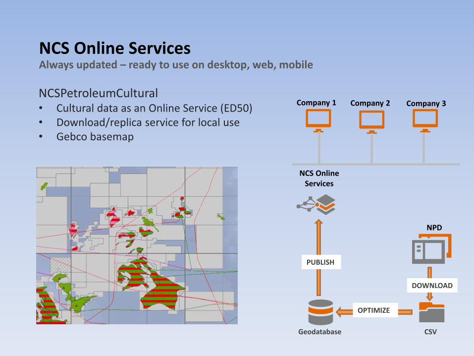
NCS Online ServicesAlways updated – ready to use on desktop, web, mobile
NCSPetroleumCultural• Cultural data as an Online Service (ED50)• Download/replica service for local use• Gebco basemap
NCS Online Services
Geodatabase CSV
NPD
DOWNLOAD
OPTIMIZE
PUBLISH
Company 1 Company 2 Company 3

GIS can give you better and faster decisions
MobileDesktopWeb
Spatial Data Warehouse
Operational Data Sources
NPD Petrel Kingdom Diskos GeoX Etc.
Collaboration Portal
Take full advantage of your existing data
GIS can give you better and faster decisions
MobileDesktopWeb
Spatial Data Warehouse
Operational Data Sources
NPD Petrel Kingdom Diskos GeoX Etc.
Collaboration Portal
Take full advantage of your existing data

GIS can add value to the entire organization
Making Mapping and GIS Available Across Your Organization
ArcGIS
Management Staff
Data Managers/ GIS Professional
EnterpriseIntegration
Offline workGeologists/
geophysicists
Provide your non-GIS users with the right interface

GIS can add value to the entire organization
Making Mapping and GIS Available Across Your Organization
ArcGIS
Management Staff
Data Managers/ GIS Professional
EnterpriseIntegration
Offline workGeologists/
geophysicists
Provide your non-GIS users with the right interface

Lundin Norway Intranet MapLicense information spread to all users

GIS can add value to the entire organization
Making Mapping and GIS Available Across Your Organization
ArcGIS
Management Staff
Data Managers/ GIS Professional
EnterpriseIntegration
Offline workGeologists/
geophysicists
Provide your non-GIS users with the right interface

Get access to subsurface data
View your seismics in ArcGIS with the rest of your data in 2D and 3D
Export to 3D Web Scenes for sharing across your organization
Geocap Seismic Explorer for ArcGIS