Embed Size (px)
Citation preview
1 © 2015 HERE - Licensed under “Creative Commons Attribution 4.0 International”
Vehicle Sensor Data Cloud Ingestion Interface Specification (v2.0.2)
2 © 2015 HERE - Licensed under “Creative Commons Attribution 4.0 International”
Table of contents
1 General Considerations2 Data Elements3 Logical Data Model4 Submission Considerations5 Encoding6 Units7 Protobuf Schema Definition
p. 3p. 4p. 52p. 57p. 59p. 60p. 61
3 © 2015 HERE - Licensed under “Creative Commons Attribution 4.0 International”
1. General Considerations
Vehicles driving on the road are equipped with a magnitude of sensors. These Sensor Data may be transferred over any kind of technology from the vehicle to an Analytic Processing Backend. Between individual vehicles and the Analytic Processing Backend, an OEM-, or System Vendor-Backend may be located as a proxy. The Sensor Data Interface Specification defines the content of Sensor Data Messages and their encoding format as they are submitted to the Analytic Processing Backend. However, the specifica-tion may be used between other components as well.
Sensor Data are submitted as messages with various type of content. Common to all kind of submitted messages is that they are related to one or multiple locations. Sensor Data Messages may be time critical and sub-mitted near real time but also may be of informational value and submitted with an acceptable delay accumulated within other Data. Neither priority, nor requirements on latency are part of the Specification.
The content and format of the Sensor Data Messages is independent of the submission latency (in near real time or delayed).
4 © 2015 HERE - Licensed under “Creative Commons Attribution 4.0 International”
2. Data Elements
All data elements have units according to the International System of Units (SI) unless otherwise explicitly noted.
2.1 GeneralData Types within this paragraph describe multiply used base and complex types.
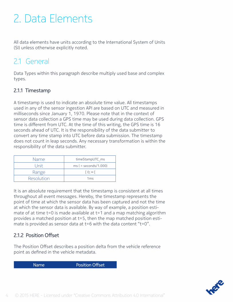
2.1.1 Timestamp
A timestamp is used to indicate an absolute time value. All timestamps used in any of the sensor ingestion API are based on UTC and measured in milliseconds since January 1, 1970. Please note that in the context of sensor data collection a GPS time may be used during data collection. GPS time is different from UTC. At the time of this writing, the GPS time is 16 seconds ahead of UTC. It is the responsibility of the data submitter to convert any time stamp into UTC before data submission. The timestamp does not count in leap seconds. Any necessary transformation is within the responsibility of the data submitter.
It is an absolute requirement that the timestamp is consistent at all times throughout all event messages. Hereby, the timestamp represents the point of time at which the sensor data has been captured and not the time at which the sensor data is available. By way of example, a position esti-mate of at time t=0 is made available at t=1 and a map matching algorithm provides a matched position at t=5, then the map matched position esti-mate is provided as sensor data at t=6 with the data content “t=0”.
Name timeStampUTC_ms
Unit ms ( = seconds/1.000)
Range [ 0; ∞ [
Resolution 1ms
2.1.2 Position Offset
The Position Offset describes a position delta from the vehicle reference point as defined in the vehicle metadata.
Name Position Offset
5 © 2015 HERE - Licensed under “Creative Commons Attribution 4.0 International”
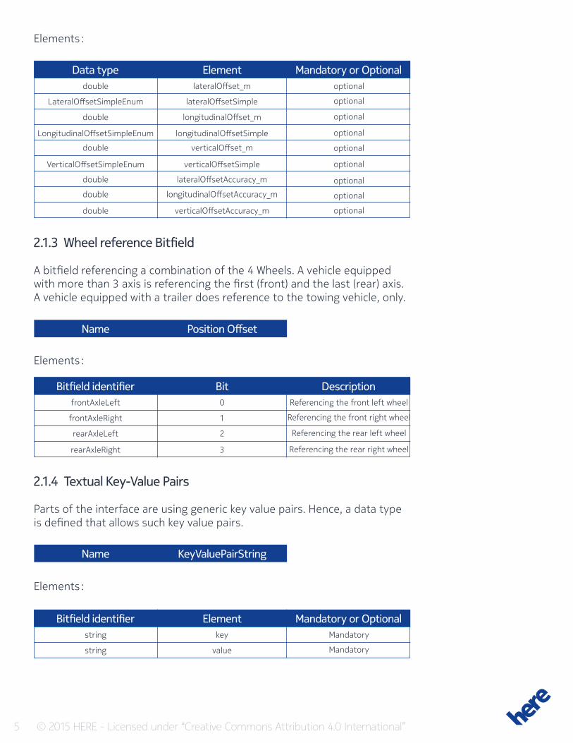
Elements :
Elements :
Data type
Bitfield identifier
Element
Bit
Mandatory or Optional
Description
double
frontAxleLeft
lateralOffset_m
0
optional
Referencing the front left wheel
optional
Referencing the front right wheel
optional
Referencing the rear left wheel
optional
Referencing the rear right wheel
optional
optional
optional
optional
optional
LateralOffsetSimpleEnum
frontAxleRight
lateralOffsetSimple
1
double
rearAxleLeft
longitudinalOffset_m
2
LongitudinalOffsetSimpleEnum
rearAxleRight
longitudinalOffsetSimple
3
double verticalOffset_m
VerticalOffsetSimpleEnum verticalOffsetSimple
double lateralOffsetAccuracy_m
double longitudinalOffsetAccuracy_m
double verticalOffsetAccuracy_m
2.1.3 Wheel reference Bitfield
A bitfield referencing a combination of the 4 Wheels. A vehicle equipped with more than 3 axis is referencing the first (front) and the last (rear) axis. A vehicle equipped with a trailer does reference to the towing vehicle, only.
2.1.4 Textual Key-Value Pairs
Parts of the interface are using generic key value pairs. Hence, a data type is defined that allows such key value pairs.
Elements :
Bitfield identifier Element Mandatory or Optionalstring key Mandatory
Mandatorystring value
Name
Name
Position Offset
KeyValuePairString
6 © 2015 HERE - Licensed under “Creative Commons Attribution 4.0 International”
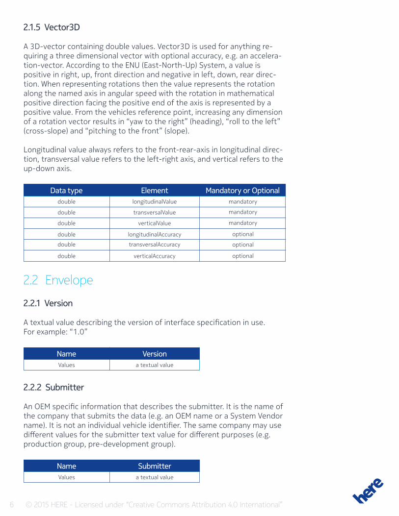
2.1.5 Vector3D
A 3D-vector containing double values. Vector3D is used for anything re-quiring a three dimensional vector with optional accuracy, e.g. an accelera-tion-vector. According to the ENU (East-North-Up) System, a value is positive in right, up, front direction and negative in left, down, rear direc-tion. When representing rotations then the value represents the rotation along the named axis in angular speed with the rotation in mathematical positive direction facing the positive end of the axis is represented by a positive value. From the vehicles reference point, increasing any dimension of a rotation vector results in “yaw to the right” (heading), “roll to the left” (cross-slope) and “pitching to the front” (slope).
Longitudinal value always refers to the front-rear-axis in longitudinal direc-tion, transversal value refers to the left-right axis, and vertical refers to the up-down axis.
Data type Element Mandatory or Optionaldouble longitudinalValue mandatory
mandatory
mandatory
optional
optional
optional
double transversalValue
double verticalValue
double longitudinalAccuracy
double transversalAccuracy
double verticalAccuracy
2.2 Envelope
2.2.1 Version
A textual value describing the version of interface specification in use. For example: “1.0”
2.2.2 Submitter
An OEM specific information that describes the submitter. It is the name of the company that submits the data (e.g. an OEM name or a System Vendor name). It is not an individual vehicle identifier. The same company may use different values for the submitter text value for different purposes (e.g. production group, pre-development group).
Name VersionValues a textual value
Name SubmitterValues a textual value
7 © 2015 HERE - Licensed under “Creative Commons Attribution 4.0 International”
2.2.3 Vehicle Meta Data
An OEM specific information that describes the submitter. It is the name of the company that submits the data (e.g. an OEM name or a System Vendor name). It is not an individual vehicle identifier. The same company may use different values for the submitter text value for different purposes (e.g. production group, pre-development group).
Name VehicleMetaData
Elements :
Data type Element Mandatory or OptionalVehicleTypeGenericEnum
double
vehicleTypeGenericEnum
vehicleReferencePointDeltaAboveGround_m
Mandatory
Mandatory
Repeated element (which allows zero entries)KeyValuePairString vehicleSpecificMetaData
double
double
double
double
FuelTypeEnum
double
FuelTypeEnum
vehicleLength_m
vehicleWidth_m
vehicleHeight_m
primaryFuelTankVolume
primaryFuelType
secondaryFuelTankVolume
secondaryFuelType
Optional
Optional
Optional
Optional
Optional (Mandatory if FuelTank is provided)
Optional
Optional (Mandatory if FuelTank is provided)
2.2.4 Transient Vehicle ID
The Transient Vehicle ID is a numeric and optional value. If the transient vehicle ID value is submitted then each submission during the drive cycle of a single vehicle shall receive the same transient vehicle ID value. This allows stitching together multiple smaller path submissions of a vehicle during a drive. A different drive of the same vehicle (e.g. on the next day) should receive a new transient vehicle ID. Within all submissions of a “Submitter” the ID space shall remain unique.
Name transientVehicleIDValues An integer value
2.2.5 Vehicle Profile ID
The Vehicle Profile ID is a numeric and optional value that is unique for a vehicle. If the vehicle Profile ID value is submitted then each submission including the profile ID is identifiable with the vehicle. This allows stitching together multiple single submissions of a vehicle during over a multitude of drives. The vehicle profile ID should be provided to events as e.g. fuel events where the fuel profile for a single vehicle should be analyzed and provided back to the single vehicle through a different interface.
8 © 2015 HERE - Licensed under “Creative Commons Attribution 4.0 International”
Name vehicleProfileIDValues An integer value
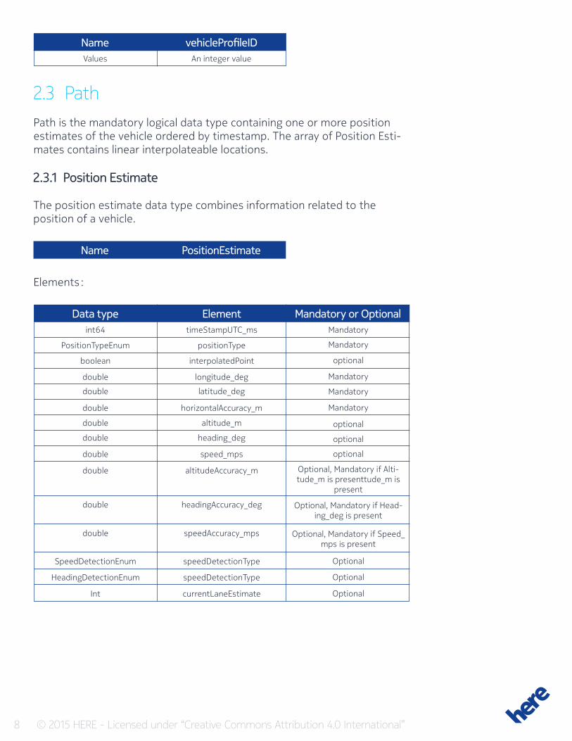
2.3 PathPath is the mandatory logical data type containing one or more position estimates of the vehicle ordered by timestamp. The array of Position Esti-mates contains linear interpolateable locations.
2.3.1 Position Estimate
The position estimate data type combines information related to the position of a vehicle.
Name PositionEstimate
Elements :
Data type Element Mandatory or Optionalint64 timeStampUTC_ms Mandatory
Mandatory
optional
Mandatory
Mandatory
Mandatory
optional
optional
optional
Optional
Optional
Optional
Optional, Mandatory if Alti-tude_m is presenttude_m is
present
Optional, Mandatory if Head-ing_deg is present
Optional, Mandatory if Speed_mps is present
PositionTypeEnum positionType
boolean interpolatedPoint
double longitude_deg
double latitude_deg
double horizontalAccuracy_m
double altitude_m
double heading_deg
double
SpeedDetectionEnum
HeadingDetectionEnum
Int
double
double
double
speed_mps
speedDetectionType
speedDetectionType
currentLaneEstimate
altitudeAccuracy_m
headingAccuracy_deg
speedAccuracy_mps
9 © 2015 HERE - Licensed under “Creative Commons Attribution 4.0 International”
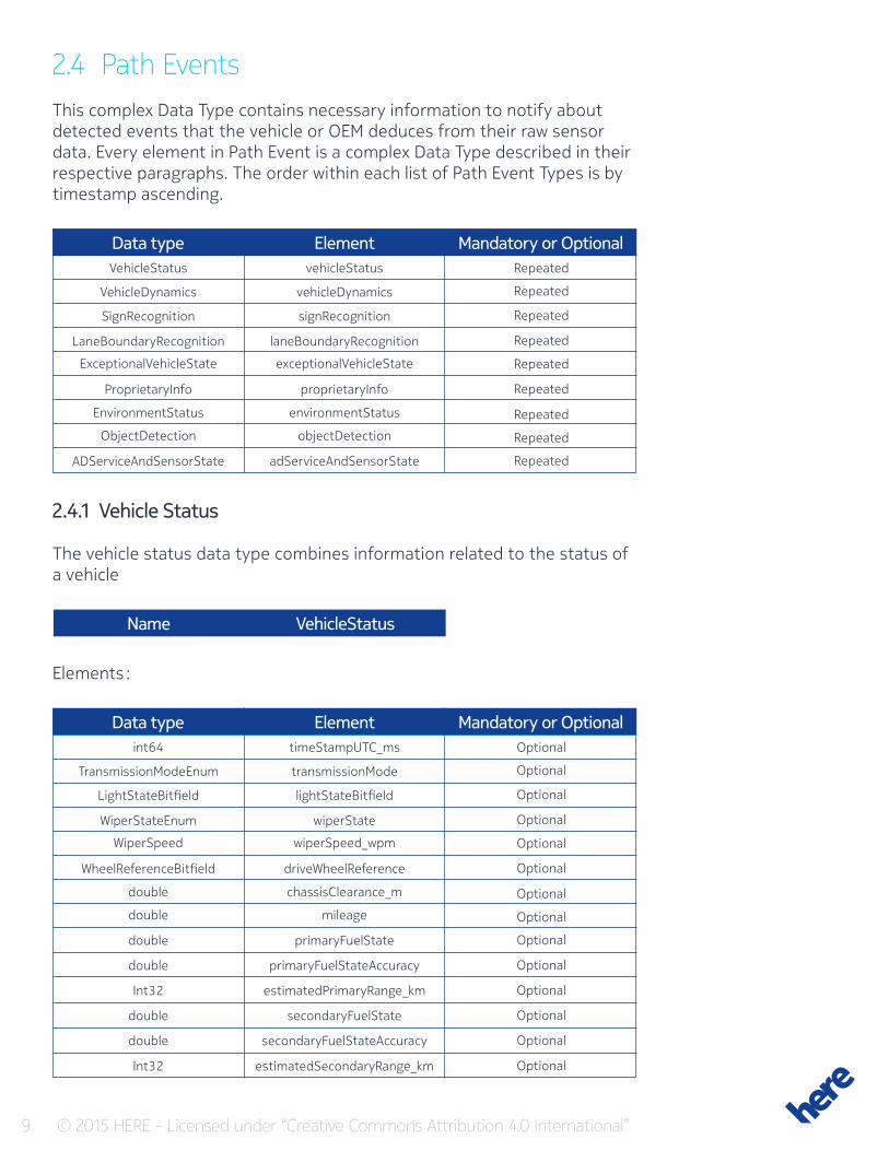
2.4 Path EventsThis complex Data Type contains necessary information to notify about detected events that the vehicle or OEM deduces from their raw sensor data. Every element in Path Event is a complex Data Type described in their respective paragraphs. The order within each list of Path Event Types is by timestamp ascending.
Data type Element Mandatory or OptionalVehicleStatus vehicleStatus Repeated
Repeated
Repeated
Repeated
Repeated
Repeated
Repeated
Repeated
Repeated
VehicleDynamics vehicleDynamics
SignRecognition signRecognition
LaneBoundaryRecognition laneBoundaryRecognition
ExceptionalVehicleState exceptionalVehicleState
ProprietaryInfo proprietaryInfo
EnvironmentStatus environmentStatus
ObjectDetection objectDetection
ADServiceAndSensorState adServiceAndSensorState
2.4.1 Vehicle Status
The vehicle status data type combines information related to the status of a vehicle
Elements :
Name VehicleStatus
Data type Element Mandatory or Optionalint64 timeStampUTC_ms Optional
Optional
Optional
Optional
Optional
Optional
Optional
Optional
Optional
Optional
Optional
Optional
Optional
Optional
TransmissionModeEnum transmissionMode
LightStateBitfield lightStateBitfield
WiperStateEnum wiperState
WiperSpeed wiperSpeed_wpm
WheelReferenceBitfield driveWheelReference
double chassisClearance_m
double mileage
double
double
Int32
double
double
Int32
primaryFuelState
primaryFuelStateAccuracy
estimatedPrimaryRange_km
secondaryFuelState
secondaryFuelStateAccuracy
estimatedSecondaryRange_km
10 © 2015 HERE - Licensed under “Creative Commons Attribution 4.0 International”
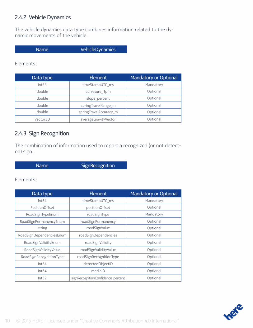
2.4.2 Vehicle Dynamics
The vehicle dynamics data type combines information related to the dy-namic movements of the vehicle.
Name
Name
VehicleDynamics
SignRecognition
Data type
Data type
Element
Element
Mandatory or Optional
Mandatory or Optional
int64
int64
timeStampUTC_ms
timeStampUTC_ms
Mandatory
Mandatory
Optional
Optional
Optional
Mandatory
Optional
Optional
Optional
Optional
Optional
Optional
Optional
Optional
Optional
Optional
Optional
Optional
double
PositionOffset
curvature_1pm
positionOffset
double
RoadSignTypeEnum
slope_percent
roadSignType
double
RoadSignPermanencyEnum
springTravelRange_m
roadSignPermanency
double
string
springTravelAccuracy_m
roadSignValue
Vector3D
RoadSignDependenciesEnum
RoadSignValidityEnum
RoadSignValidityValue
RoadSignRecognitionType
Int64
Int64
Int32
averageGravityVector
roadSignDependencies
roadSignValidity
roadSignValidityValue
roadSignRecognitionType
detectedObjectID
mediaID
signRecognitionConfidence_percent
Elements :
Elements :
2.4.3 Sign Recognition
The combination of information used to report a recognized (or not detect-ed) sign.
11 © 2015 HERE - Licensed under “Creative Commons Attribution 4.0 International”
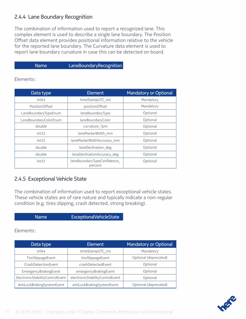
2.4.4 Lane Boundary Recognition
The combination of information used to report a recognized lane. This complex element is used to describe a single lane boundary. The Position Offset data element provides positional information relative to the vehicle for the reported lane boundary. The Curvature data element is used to report lane boundary curvature in case this can be detected on board.
Name LaneBoundaryRecognition
Data type Element Mandatory or Optionalint64 timeStampUTC_ms Mandatory
Mandatory
Optional
Optional
Optional
Optional
Optional
Optional
Optional
Optional
PositionOffset positionOffset
LaneBoundaryTypeEnum laneBoundaryType
LaneBoundaryColorEnum laneBoundaryColor
double curvature_1pm
int32
int32
double
double
Int32
laneMarkerWidth_mm
laneMarkerWidthAccuracy_mm
laneDeclination_deg
laneDeclinationAccuracy_deg
laneBoundaryTypeConfidence_percent
Elements :
2.4.5 Exceptional Vehicle State
The combination of information used to report exceptional vehicle states. These vehicle states are of rare nature and typically indicate a non-regular condition (e.g. tires slipping, crash detected, strong breaking).
Name ExceptionalVehicleState
Data type Element Mandatory or Optionalint64 timeStampUTC_ms Mandatory
Optional (deprecated)
Optional
Optional
Optional
Optional (deprecated)
TireSlippageEvent tireSlippageEvent
CrashDetectionEvent crashDetectedEvent
EmergencyBrakingEvent emergencyBrakingEvent
ElectronicStabilityControlEvent electronicStabilityControlEvent
AntiLockBrakingSystemEvent antiLockBrakingSystemEvent
Elements :
12 © 2015 HERE - Licensed under “Creative Commons Attribution 4.0 International”
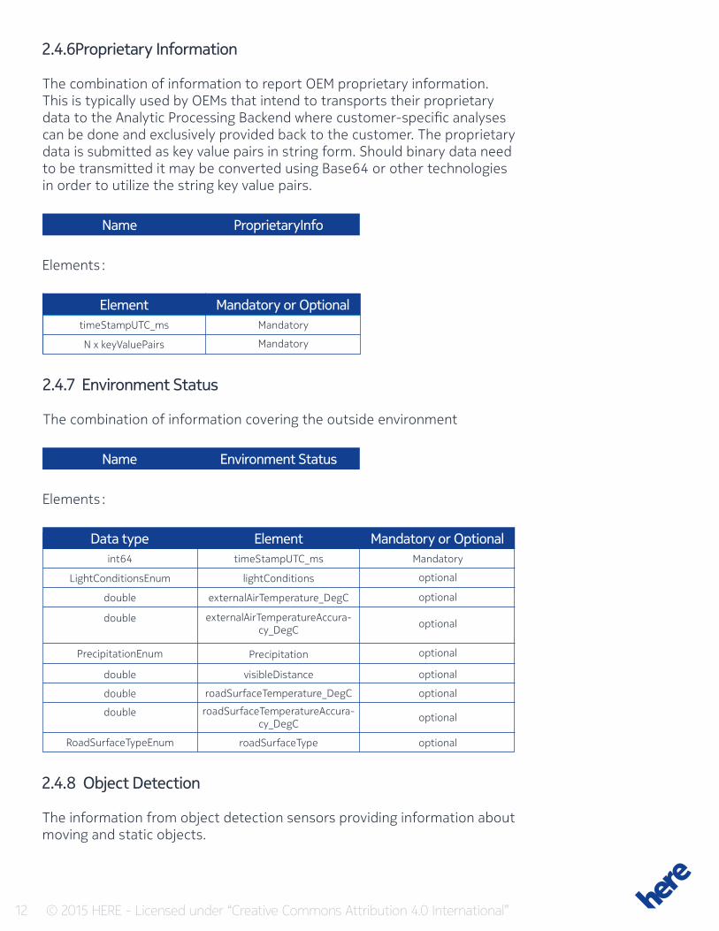
2.4.6Proprietary Information
The combination of information to report OEM proprietary information. This is typically used by OEMs that intend to transports their proprietary data to the Analytic Processing Backend where customer-specific analyses can be done and exclusively provided back to the customer. The proprietary data is submitted as key value pairs in string form. Should binary data need to be transmitted it may be converted using Base64 or other technologies in order to utilize the string key value pairs.
Name
Name
ProprietaryInfo
Environment Status
Element Mandatory or OptionaltimeStampUTC_ms Mandatory
MandatoryN x keyValuePairs
Elements :
2.4.7 Environment Status
The combination of information covering the outside environment
Elements :
Data type Element Mandatory or Optionalint64 timeStampUTC_ms Mandatory
optional
optional
optional
optional
optional
optional
optional
optional
LightConditionsEnum lightConditions
double externalAirTemperature_DegC
Precipitation
visibleDistance
roadSurfaceType
roadSurfaceTemperature_DegC
roadSurfaceTemperatureAccura-cy_DegC
double externalAirTemperatureAccura-cy_DegC
PrecipitationEnum
double
double
double
RoadSurfaceTypeEnum
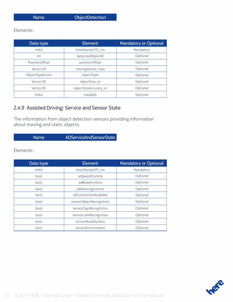
2.4.8 Object Detection
The information from object detection sensors providing information about moving and static objects.
13 © 2015 HERE - Licensed under “Creative Commons Attribution 4.0 International”
Name
Name
ObjectDetection
ADServiceAndSensorState
Elements :
Elements :
Data type Element Mandatory or Optionalint64 timeStampUTC_ms Mandatory
Optional
Optional
Optional
Optional
Optional
Optional
Optional
int detectedObjectID
PositionOffset positionOffset
Vector3D movingVector_mps
ObjectTypeEnum objectType
Vector3D
Vector3D
Int64
objectSize_m
objectSizeAccuracy_m
mediaID
2.4.9 Assisted Driving: Service and Sensor State
The information from object detection sensors providing information about moving and static objects.
Data type Element Mandatory or Optionalint64 timeStampUTC_ms Mandatory
Optional
Optional
Optional
Optional
Optional
Optional
Optional
Optional
Optional
bool adSpeedControl
bool adBrakeControl
bool adSteeringControl
bool adConnectionAvailable
bool
bool
bool
bool
bool
sensorObjectRecognition
sensorSignRecognition
sensorLaneRecognition
sensorRoadSurface
sensorEnvironment
14 © 2015 HERE - Licensed under “Creative Commons Attribution 4.0 International”
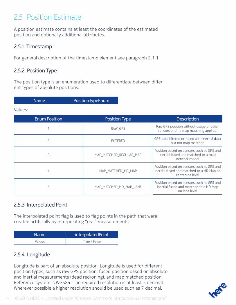
2.5 Position EstimateA position estimate contains at least the coordinates of the estimated position and optionally additional attributes.
2.5.1 Timestamp
For general description of the timestamp element see paragraph 2.1.1
2.5.2 Position Type
The position type is an enumeration used to differentiate between differ-ent types of absolute positions.
Name PositionTypeEnum
Values:
Enum Position
Name
Position Type
interpolatedPoint
Description
1
Values
2
3
4
5
RAW_GPS
True / False
FILTERED
MAP_MATCHED_REGULAR_MAP
MAP_MATCHED_HD_MAP
MAP_MATCHED_HD_MAP_LANE
Raw GPS position without usage of other sensors and no map matching applied.
GPS data filtered or fused with inertial data but not map matched
Position based on sensors such as GPS and inertial fused and matched to a road
network model
Position based on sensors such as GPS and inertial fused and matched to a HD Map on
centerline level
Position based on sensors such as GPS and inertial fused and matched to a HD Map
on lane level
2.5.3 Interpolated Point
The interpolated point flag is used to flag points in the path that were created artificially by interpolating “real” measurements.
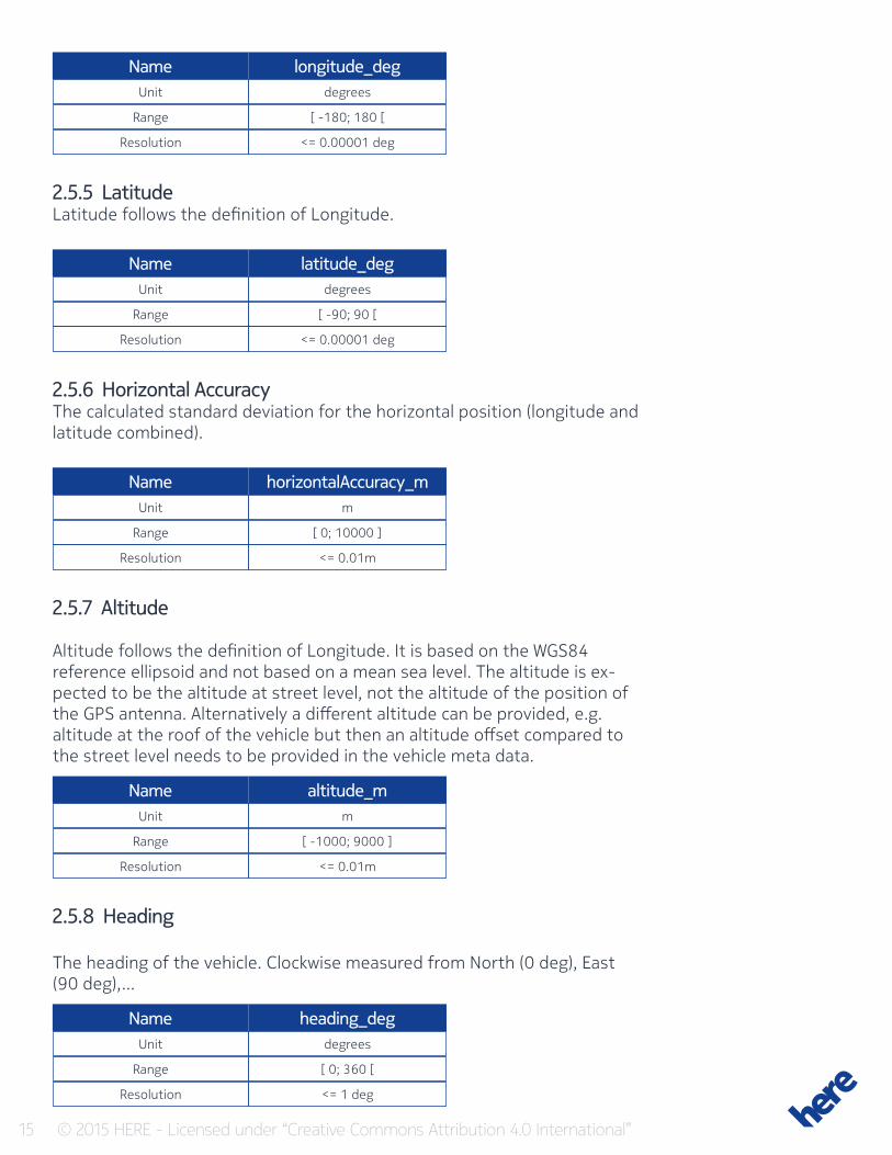
2.5.4 Longitude
Longitude is part of an absolute position. Longitude is used for different position types, such as raw GPS position, fused position based on absolute and inertial measurements (dead reckoning), and map matched position. Reference system is WGS84. The required resolution is at least 5 decimal. Wherever possible a higher resolution should be used such as 7 decimal.
15 © 2015 HERE - Licensed under “Creative Commons Attribution 4.0 International”
Name
Name
Name
Name
Name
longitude_deg
latitude_deg
horizontalAccuracy_m
altitude_m
heading_deg
Unit
Unit
Unit
Unit
Unit
Range
Range
Range
Range
Range
Resolution
Resolution
Resolution
Resolution
Resolution
degrees
degrees
m
m
degrees
[ -180; 180 [
[ -90; 90 [
[ 0; 10000 ]
[ -1000; 9000 ]
[ 0; 360 [
<= 0.00001 deg
<= 0.00001 deg
<= 0.01m
<= 0.01m
<= 1 deg
2.5.5 LatitudeLatitude follows the definition of Longitude.
2.5.6 Horizontal AccuracyThe calculated standard deviation for the horizontal position (longitude and latitude combined).
2.5.7 Altitude
Altitude follows the definition of Longitude. It is based on the WGS84 reference ellipsoid and not based on a mean sea level. The altitude is ex-pected to be the altitude at street level, not the altitude of the position of the GPS antenna. Alternatively a different altitude can be provided, e.g. altitude at the roof of the vehicle but then an altitude offset compared to the street level needs to be provided in the vehicle meta data.
2.5.8 Heading
The heading of the vehicle. Clockwise measured from North (0 deg), East (90 deg),…
16 © 2015 HERE - Licensed under “Creative Commons Attribution 4.0 International”
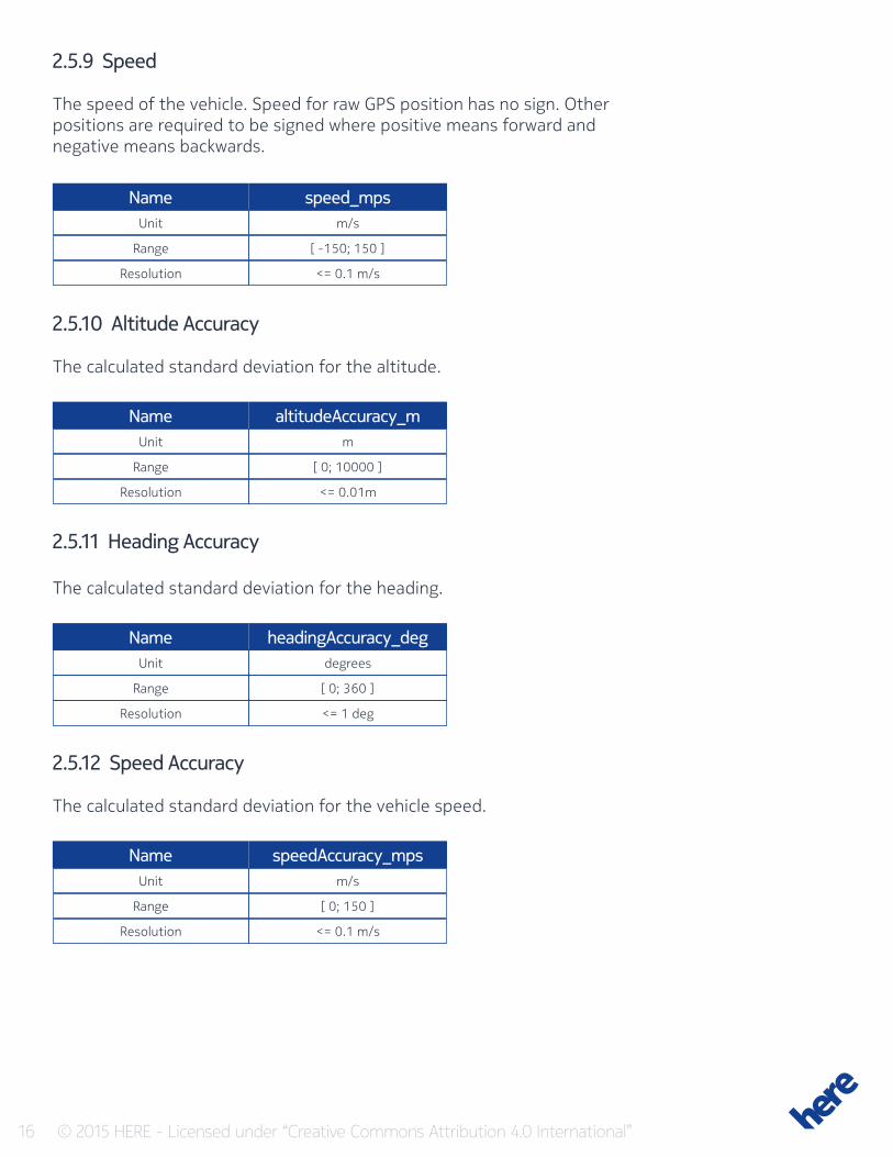
2.5.9 Speed
The speed of the vehicle. Speed for raw GPS position has no sign. Other positions are required to be signed where positive means forward and negative means backwards.
Name
Name
Name
Name
speed_mps
altitudeAccuracy_m
headingAccuracy_deg
speedAccuracy_mps
Unit
Unit
Unit
Unit
Range
Range
Range
Range
Resolution
Resolution
Resolution
Resolution
m/s
m
degrees
m/s
[ -150; 150 ]
[ 0; 10000 ]
[ 0; 360 ]
[ 0; 150 ]
<= 0.1 m/s
<= 0.01m
<= 1 deg
<= 0.1 m/s
2.5.10 Altitude Accuracy
The calculated standard deviation for the altitude.
2.5.11 Heading Accuracy
The calculated standard deviation for the heading.
2.5.12 Speed Accuracy
The calculated standard deviation for the vehicle speed.
17 © 2015 HERE - Licensed under “Creative Commons Attribution 4.0 International”
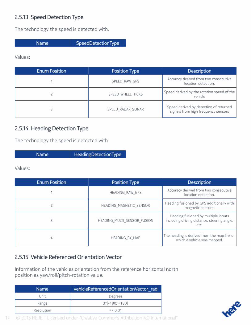
2.5.13 Speed Detection Type
The technology the speed is detected with.
Enum Position
Enum Position
Position Type
Position Type
Description
Description
1
1
2
2
3
3
4
SPEED_RAW_GPS
HEADING_RAW_GPS
SPEED_WHEEL_TICKS
HEADING_MAGNETIC_SENSOR
SPEED_RADAR_SONAR
HEADING_MULTI_SENSOR_FUSION
HEADING_BY_MAP
Accuracy derived from two consecutive location detection.
Accuracy derived from two consecutive location detection.
Speed derived by the rotation speed of the vehicle
Heading fusioned by GPS additionally with magnetic sensors.
Speed derived by detection of returned signals from high frequency sensors
Heading fusioned by multiple inputs including driving distance, steering angle,
etc.
The heading is derived from the map link on which a vehicle was mapped.
Name
Name
SpeedDetectionType
HeadingDetectionType
Values:
Values:
2.5.14 Heading Detection Type
The technology the speed is detected with.
2.5.15 Vehicle Referenced Orientation Vector
Information of the vehicles orientation from the reference horizontal north position as yaw/roll/pitch-rotation value.
Name vehicleReferencedOrientationVector_radUnit
Range
Resolution
Degrees
3*[-180; +180]
<= 0.01

18 © 2015 HERE - Licensed under “Creative Commons Attribution 4.0 International”
By way of example, a vector of {lateral=-30,longitudinal=45, vertical=90} corresponds to a rotation of 90° to the right (EAST), a roll of 45° along the longitudinal axis (leaning left) and a pitch of -30° along the lateral axis (pointing upwards).
2.5.16 Current Lane Estimation
The current lane number as estimation according to the vehicle internal sensors where lane 0 is most inner lane (left on right hand traffic and right on left hand traffic)
Name currentLaneEstimateUnit
Range
Resolution
N/A
[ 0; 20]
1
2.6 Vehicle Meta DataThe vehicle metadata provides information about the vehicle that is valid for the entire path. This includes vehicle type information, the vehicle refer-ence point. All absolute positions (longitude / latitude) that are reported to the Sensor Data Ingestion Interface are expected to be at the center of the vehicle. All offsets that are reported are expected to be offsets from this center point of the vehicle. Altitude that is reported to the Interface are expected to be altitude on the ground (not the altitude of the location of the GPS antenna). Instead of providing the altitude on the ground, it is possible to report a different altitude with a constant offset. This offset from the ground must be provided through the vehicle metadata.
2.6.1 Vehicle Type (Generic)
The generic vehicle type is an enumeration used to provide information what type of vehicle the sensor data produced.
Name VehicleTypeGenericEnum
Enum Position Vehicle Type Description1
2
3
BUS
DELIVERY_TRUCK
EMERGENCY_VEHICLE
A bus
A delivery truck (typically a smaller truck)
For example an ambulance, police, fire-truck or similar which is allowed to break normal
traffic rules
Values
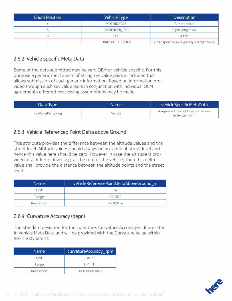
19 © 2015 HERE - Licensed under “Creative Commons Attribution 4.0 International”
Enum Position
Data Type
Vehicle Type
Name
Description
vehicleSpecificMetaData
4
KeyValuePairString
5
6
7
MOTORCYCLE
Values
PASSENGER_CAR
TAXI
TRANSPORT_TRUCK
A motorcycle
A repeated field of keys and values in textual form
A passenger car
A taxi
A transport truck (typically a larger truck)
2.6.2 Vehicle specific Meta Data
Some of the data submitted may be very OEM or vehicle specific. For this purpose a generic mechanism of string key value pairs is included that allows submission of such generic information. Based on information pro-vided through such key value pairs in conjunction with individual OEM agreements different processing assumptions may be made.
2.6.3 Vehicle Referenced Point Delta above Ground
This attribute provides the difference between the altitude values and the street level. Altitude values should always be provided at street level and hence this value here should be zero. However in case the altitude is pro-vided at a different level (e.g. at the roof of the vehicle) then this delta value shall provide the distance between the altitude points and the street level.
Name
Name
vehicleReferencePointDeltaAboveGround_m
curvatureAccuracy_1pm
Unit
Unit
Range
Range
Resolution
Resolution
m
m-1
[ 0; 20 ]
[ -1 ; 1 ]
<= 0.01m
<= 0.00001m-1
2.6.4 Curvature Accuracy (depr.)
The standard deviation for the curvature. Curvature Accuracy is deprecated in Vehicle Meta Data and will be provided with the Curvature Value within Vehicle Dynamics
20 © 2015 HERE - Licensed under “Creative Commons Attribution 4.0 International”
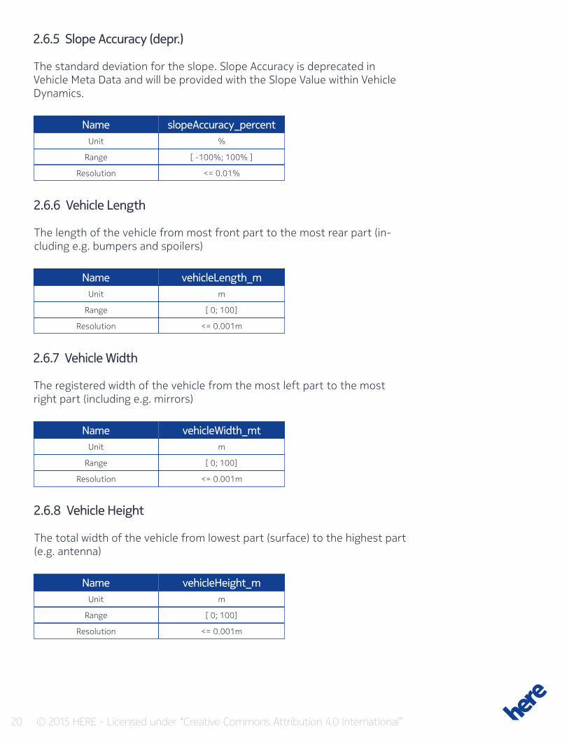
2.6.5 Slope Accuracy (depr.)
The standard deviation for the slope. Slope Accuracy is deprecated in Vehicle Meta Data and will be provided with the Slope Value within Vehicle Dynamics.
Name
Name
Name
Name
slopeAccuracy_percent
vehicleLength_m
vehicleWidth_mt
vehicleHeight_m
Unit
Unit
Unit
Unit
Range
Range
Range
Range
Resolution
Resolution
Resolution
Resolution
%
m
m
m
[ -100%; 100% ]
[ 0; 100]
[ 0; 100]
[ 0; 100]
<= 0.01%
<= 0.001m
<= 0.001m
<= 0.001m
2.6.6 Vehicle Length
The length of the vehicle from most front part to the most rear part (in-cluding e.g. bumpers and spoilers)
2.6.7 Vehicle Width
The registered width of the vehicle from the most left part to the most right part (including e.g. mirrors)
2.6.8 Vehicle Height
The total width of the vehicle from lowest part (surface) to the highest part (e.g. antenna)
21 © 2015 HERE - Licensed under “Creative Commons Attribution 4.0 International”
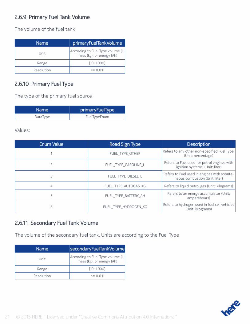
2.6.9 Primary Fuel Tank Volume
The volume of the fuel tank
Name
Name
primaryFuelTankVolume
primaryFuelType
Unit
DataType
Range
Resolution
According to Fuel Type volume (l), mass (kg), or energy (Ah)
FuelTypeEnum
[ 0; 1000]
<= 0.01l
2.6.10 Primary Fuel Type
The type of the primary fuel source
Values:
Enum Value Road Sign Type Description
1
2
3
4
5
6
FUEL_TYPE_OTHER
FUEL_TYPE_GASOLINE_L
FUEL_TYPE_DIESEL_L
FUEL_TYPE_AUTOGAS_KG
FUEL_TYPE_BATTERY_AH
FUEL_TYPE_HYDROGEN_KG
Refers to any other non-specified Fuel Type. (Unit: percentage)
Refers to Fuel used for petrol engines with ignition systems. (Unit: liter)
Refers to Fuel used in engines with sponta-neous combustion (Unit: liter)
Refers to liquid petrol gas (Unit: kilograms)
Refers to an energy accumulator (Unit: amperehours)
Refers to hydrogen used in fuel cell vehicles (Unit: kilograms)
2.6.11 Secondary Fuel Tank Volume
The volume of the secondary fuel tank. Units are according to the Fuel Type
Name secondaryFuelTankVolume
Unit
Range
Resolution
According to Fuel Type volume (l), mass (kg), or energy (Ah)
[ 0; 1000]
<= 0.01l
22 © 2015 HERE - Licensed under “Creative Commons Attribution 4.0 International”
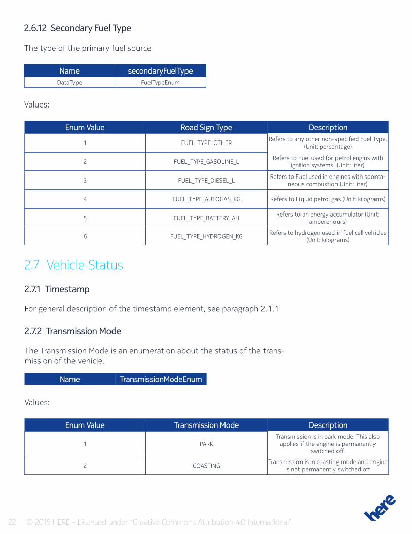
2.6.12 Secondary Fuel Type
The type of the primary fuel source
Name secondaryFuelTypeDataType FuelTypeEnum
Values:
Enum Value Road Sign Type Description
1
2
3
4
5
6
FUEL_TYPE_OTHER
FUEL_TYPE_GASOLINE_L
FUEL_TYPE_DIESEL_L
FUEL_TYPE_AUTOGAS_KG
FUEL_TYPE_BATTERY_AH
FUEL_TYPE_HYDROGEN_KG
Refers to any other non-specified Fuel Type. (Unit: percentage)
Refers to Fuel used for petrol engins with igntion systems. (Unit: liter)
Refers to Fuel used in engines with sponta-neous combustion (Unit: liter)
Refers to Liquid petrol gas (Unit: kilograms)
Refers to an energy accumulator (Unit: amperehours)
Refers to hydrogen used in fuel cell vehicles (Unit: kilograms)
2.7 Vehicle Status
2.7.1 Timestamp
For general description of the timestamp element, see paragraph 2.1.1
2.7.2 Transmission Mode
The Transmission Mode is an enumeration about the status of the trans-mission of the vehicle.
Name TransmissionModeEnum
Enum Value Transmission Mode Description
1
2
PARK
COASTING
Transmission is in park mode. This also applies if the engine is permanently
switched off.
Transmission is in coasting mode and engine is not permanently switched off
Values:
23 © 2015 HERE - Licensed under “Creative Commons Attribution 4.0 International”
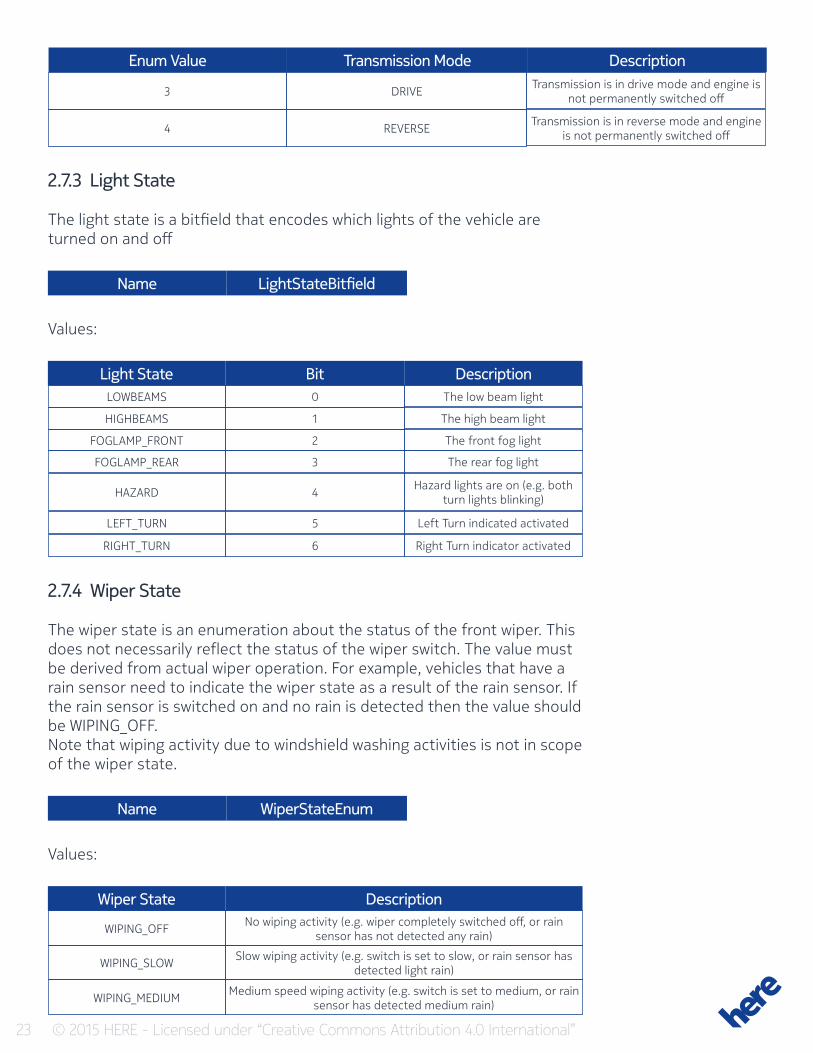
3
4
DRIVE
REVERSE
Transmission is in drive mode and engine is not permanently switched off
Transmission is in reverse mode and engine is not permanently switched off
Enum Value Transmission Mode Description
2.7.3 Light State
The light state is a bitfield that encodes which lights of the vehicle are turned on and off
Name LightStateBitfield
Light State Bit DescriptionLOWBEAMS
HIGHBEAMS
FOGLAMP_FRONT
FOGLAMP_REAR
HAZARD
LEFT_TURN
RIGHT_TURN
0
1
2
3
4
5
6
The low beam light
The high beam light
The front fog light
The rear fog light
Hazard lights are on (e.g. both turn lights blinking)
Left Turn indicated activated
Right Turn indicator activated
Values:
2.7.4 Wiper State
The wiper state is an enumeration about the status of the front wiper. This does not necessarily reflect the status of the wiper switch. The value must be derived from actual wiper operation. For example, vehicles that have a rain sensor need to indicate the wiper state as a result of the rain sensor. If the rain sensor is switched on and no rain is detected then the value should be WIPING_OFF.Note that wiping activity due to windshield washing activities is not in scope of the wiper state.
Name WiperStateEnum
Wiper State Description
WIPING_OFF
WIPING_SLOW
WIPING_MEDIUM
No wiping activity (e.g. wiper completely switched off, or rain sensor has not detected any rain)
Slow wiping activity (e.g. switch is set to slow, or rain sensor has detected light rain)
Medium speed wiping activity (e.g. switch is set to medium, or rain sensor has detected medium rain)
Values:
24 © 2015 HERE - Licensed under “Creative Commons Attribution 4.0 International”
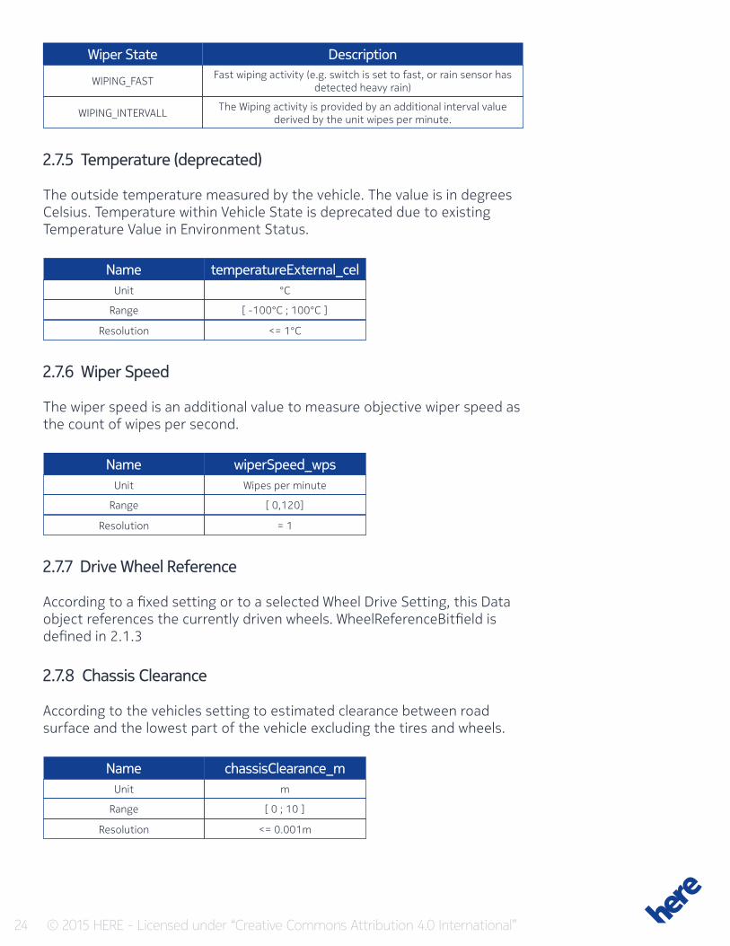
Wiper State Description
WIPING_FAST
WIPING_INTERVALL
Fast wiping activity (e.g. switch is set to fast, or rain sensor has detected heavy rain)
The Wiping activity is provided by an additional interval value derived by the unit wipes per minute.
2.7.5 Temperature (deprecated)
The outside temperature measured by the vehicle. The value is in degrees Celsius. Temperature within Vehicle State is deprecated due to existing Temperature Value in Environment Status.
Name
Name
Name
temperatureExternal_cel
wiperSpeed_wps
chassisClearance_m
Unit
Unit
Unit
Range
Range
Range
Resolution
Resolution
Resolution
°C
Wipes per minute
m
[ -100°C ; 100°C ]
[ 0,120]
[ 0 ; 10 ]
<= 1°C
= 1
<= 0.001m
2.7.6 Wiper Speed
The wiper speed is an additional value to measure objective wiper speed as the count of wipes per second.
2.7.7 Drive Wheel Reference
According to a fixed setting or to a selected Wheel Drive Setting, this Data object references the currently driven wheels. WheelReferenceBitfield is defined in 2.1.3
2.7.8 Chassis Clearance
According to the vehicles setting to estimated clearance between road surface and the lowest part of the vehicle excluding the tires and wheels.
25 © 2015 HERE - Licensed under “Creative Commons Attribution 4.0 International”
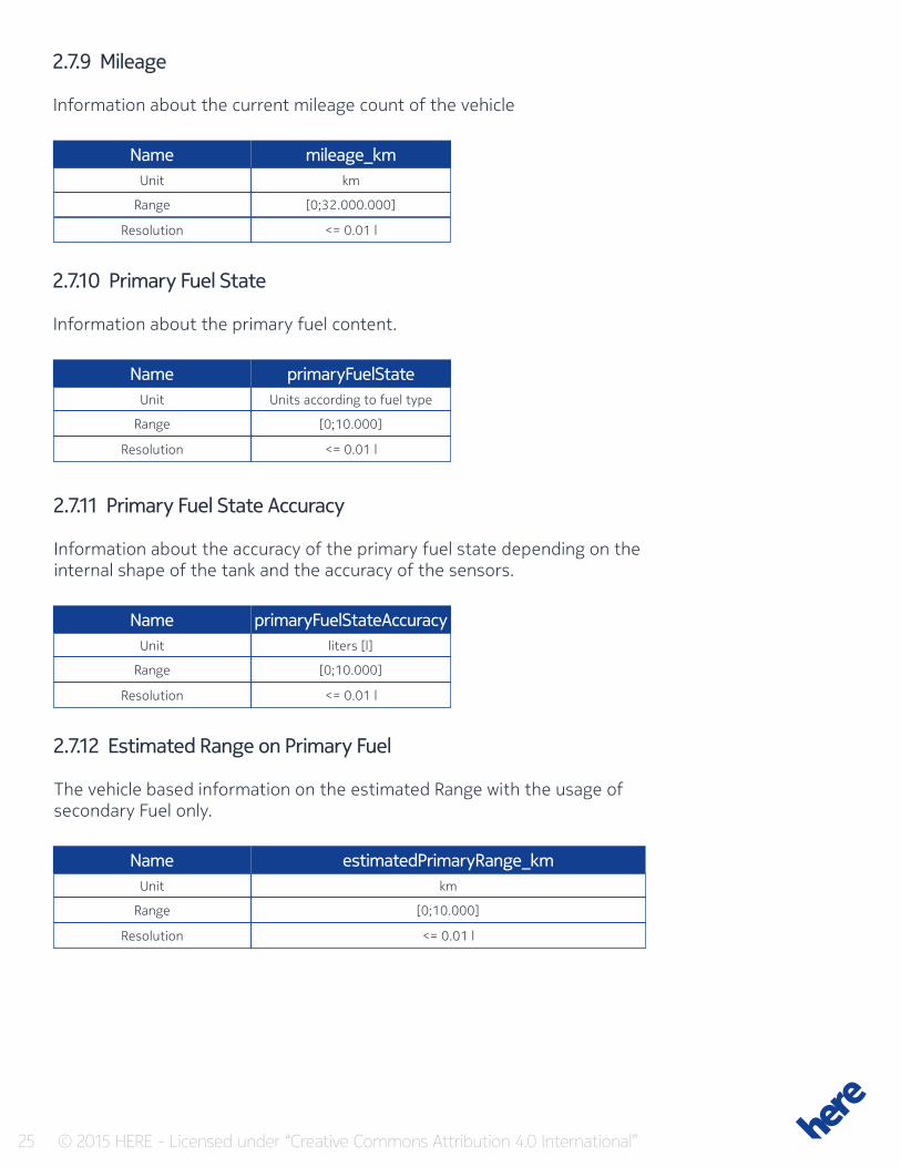
2.7.9 Mileage
Information about the current mileage count of the vehicle
Name
Name
Name
Name
mileage_km
primaryFuelState
primaryFuelStateAccuracy
estimatedPrimaryRange_km
Unit
Unit
Unit
Unit
Range
Range
Range
Range
Resolution
Resolution
Resolution
Resolution
km
Units according to fuel type
liters [l]
km
[0;32.000.000]
[0;10.000]
[0;10.000]
[0;10.000]
<= 0.01 l
<= 0.01 l
<= 0.01 l
<= 0.01 l
2.7.10 Primary Fuel State
Information about the primary fuel content.
2.7.11 Primary Fuel State Accuracy
Information about the accuracy of the primary fuel state depending on the internal shape of the tank and the accuracy of the sensors.
2.7.12 Estimated Range on Primary Fuel
The vehicle based information on the estimated Range with the usage of secondary Fuel only.
26 © 2015 HERE - Licensed under “Creative Commons Attribution 4.0 International”
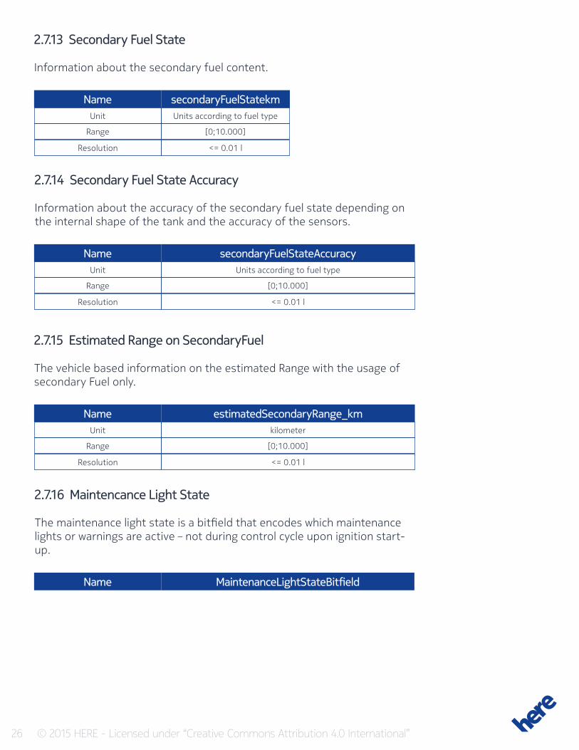
Name
Name
Name
secondaryFuelStatekm
secondaryFuelStateAccuracy
estimatedSecondaryRange_km
Unit
Unit
Unit
Range
Range
Range
Resolution
Resolution
Resolution
Units according to fuel type
Units according to fuel type
kilometer
[0;10.000]
[0;10.000]
[0;10.000]
<= 0.01 l
<= 0.01 l
<= 0.01 l
2.7.13 Secondary Fuel State
Information about the secondary fuel content.
2.7.14 Secondary Fuel State Accuracy
Information about the accuracy of the secondary fuel state depending on the internal shape of the tank and the accuracy of the sensors.
2.7.15 Estimated Range on SecondaryFuel
The vehicle based information on the estimated Range with the usage of secondary Fuel only.
2.7.16 Maintencance Light State
The maintenance light state is a bitfield that encodes which maintenance lights or warnings are active – not during control cycle upon ignition start-up.
Name MaintenanceLightStateBitfield
27 © 2015 HERE - Licensed under “Creative Commons Attribution 4.0 International”
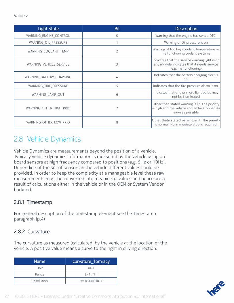
Values:
WARNING_ENGINE_CONTROL
WARNING_OIL_PRESSURE
WARNING_COOLANT_TEMP
WARNING_VEHICLE_SERVICE
WARNING_BATTERY_CHARGING
WARNING_TIRE_PRESSURE
WARNING_LAMP_OUT
WARNING_OTHER_HIGH_PRIO
WARNING_OTHER_LOW_PRIO
0
1
2
3
4
5
6
7
8
Warning that the engine has sent a DTC.
Warning of Oil pressure is on
Warning of too high coolant temperature or malfunctioning coolant systems
Indicates that the service warning light is on any module indicates that it needs service
(e.g. malfunctioning)
Indicates that the battery charging alert is on.
Indicates that the tire pressure alarm is on.
Indicates that one or more light bulbs may not be illuminated
Other than stated warning is lit. The priority is high and the vehicle should be stopped as
soon as possible
Other thatn stated warning is lit. The priority is normal. No immediate stop is required.
Light State Bit Description
2.8 Vehicle DynamicsVehicle Dynamics are measurements beyond the position of a vehicle. Typically vehicle dynamics information is measured by the vehicle using on board sensors at high frequency compared to positions (e.g. 5Hz or 10Hz). Depending of the set of sensors in the vehicle different values could be provided. In order to keep the complexity at a manageable level these raw measurements must be converted into meaningful values and hence are a result of calculations either in the vehicle or in the OEM or System Vendor backend.
2.8.1 Timestamp
For general description of the timestamp element see the Timestamp paragraph (p.4)
2.8.2 Curvature
The curvature as measured (calculated) by the vehicle at the location of the vehicle. A positive value means a curve to the right in driving direction.
Name curvature_1pmracyUnit
Range
Resolution
m-1
[ -1 ; 1 ]
<= 0.0001m-1
28 © 2015 HERE - Licensed under “Creative Commons Attribution 4.0 International”
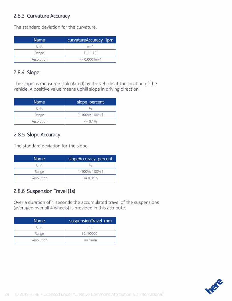
2.8.3 Curvature Accuracy
The standard deviation for the curvature.
Name
Name
Name
Name
curvatureAccuracy_1pm
slope_percent
slopeAccuracy_percent
suspensionTravel_mm
Unit
Unit
Unit
Unit
Range
Range
Range
Range
Resolution
Resolution
Resolution
Resolution
m-1
%
%
mm
[ -1 ; 1 ]
[ -100%; 100% ]
[ -100%; 100% ]
[0; 10000]
<= 0.0001m-1
<= 0.1%
<= 0.01%
== 1mm
2.8.4 Slope
The slope as measured (calculated) by the vehicle at the location of the vehicle. A positive value means uphill slope in driving direction.
2.8.5 Slope Accuracy
The standard deviation for the slope.
2.8.6 Suspension Travel (1s)
Over a duration of 1 seconds the accumulated travel of the suspensions (averaged over all 4 wheels) is provided in this attribute.
29 © 2015 HERE - Licensed under “Creative Commons Attribution 4.0 International”
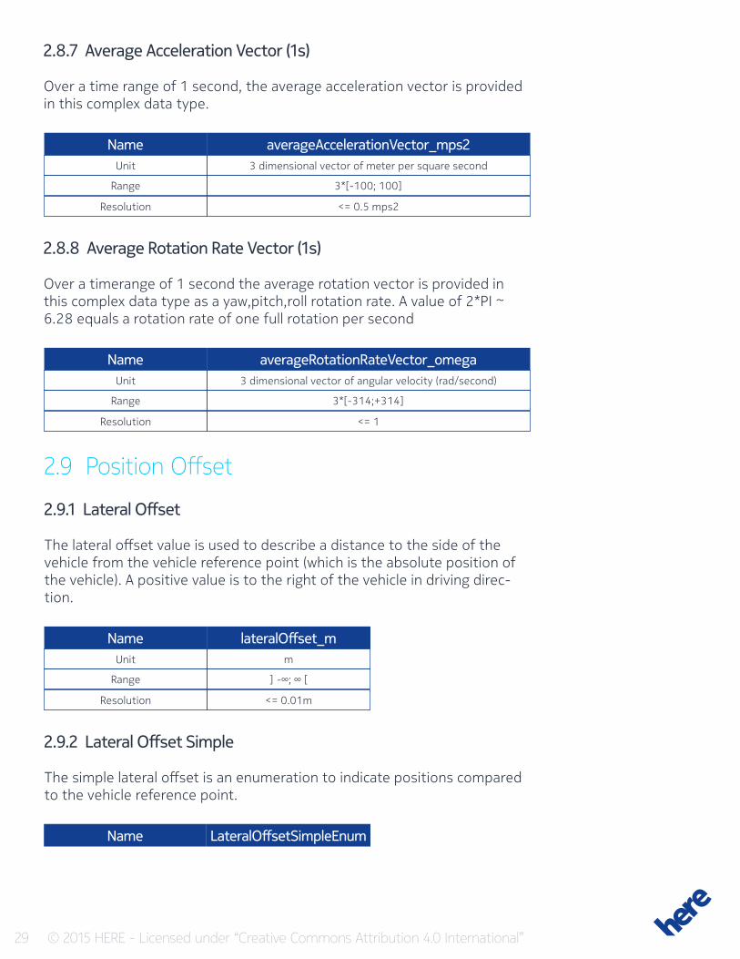
2.8.7 Average Acceleration Vector (1s)
Over a time range of 1 second, the average acceleration vector is provided in this complex data type.
Name
Name
Name
averageAccelerationVector_mps2
averageRotationRateVector_omega
lateralOffset_m
Unit
Unit
Unit
Range
Range
Range
Resolution
Resolution
Resolution
3 dimensional vector of meter per square second
3 dimensional vector of angular velocity (rad/second)
m
3*[-100; 100]
3*[-314;+314]
] -∞; ∞ [
<= 0.5 mps2
<= 1
<= 0.01m
2.8.8 Average Rotation Rate Vector (1s)
Over a timerange of 1 second the average rotation vector is provided in this complex data type as a yaw,pitch,roll rotation rate. A value of 2*PI ~ 6.28 equals a rotation rate of one full rotation per second
2.9 Position Offset
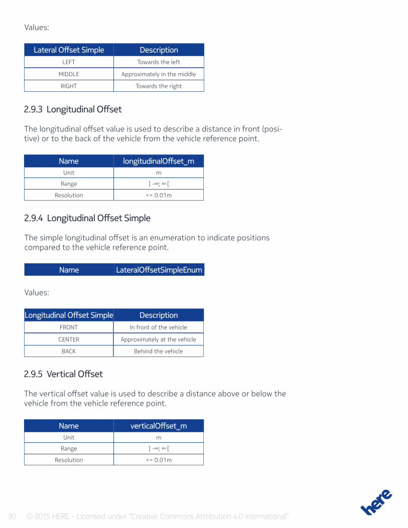
2.9.1 Lateral Offset
The lateral offset value is used to describe a distance to the side of the vehicle from the vehicle reference point (which is the absolute position of the vehicle). A positive value is to the right of the vehicle in driving direc-tion.
2.9.2 Lateral Offset Simple
The simple lateral offset is an enumeration to indicate positions compared to the vehicle reference point.
Name LateralOffsetSimpleEnum
30 © 2015 HERE - Licensed under “Creative Commons Attribution 4.0 International”
LEFT
FRONT
MIDDLE
CENTER
RIGHT
BACK
Towards the left
In front of the vehicle
Approximately in the middle
Approximately at the vehicle
Towards the right
Behind the vehicle
Lateral Offset Simple
Longitudinal Offset Simple
Description
Description
2.9.3 Longitudinal Offset
The longitudinal offset value is used to describe a distance in front (posi-tive) or to the back of the vehicle from the vehicle reference point.
Name
Name
longitudinalOffset_m
verticalOffset_m
Unit
Unit
Range
Range
Resolution
Resolution
m
m
] -∞; ∞ [
] -∞; ∞ [
<= 0.01m
<= 0.01m
2.9.4 Longitudinal Offset Simple
The simple longitudinal offset is an enumeration to indicate positions compared to the vehicle reference point.
Name LateralOffsetSimpleEnum
Values:
Values:
2.9.5 Vertical Offset
The vertical offset value is used to describe a distance above or below the vehicle from the vehicle reference point.
31 © 2015 HERE - Licensed under “Creative Commons Attribution 4.0 International”
2.9.6 Vertical Offset Simple
The simple vertical offset is an enumeration to indicate positions compared to the vehicle reference point.
ABOVE
AT_LEVEL
BELOW
Above the vehicle
Approximately at the level of the vehicle
Below the vehicle
Longitudinal Offset Simple Description
Name VerticalOffsetSimpleEnum
Values:
2.9.1 Lateral Offset Accuracy
The lateral offset accuracy value is used to describe the confidence of the lateral offset.
Name
Name
Name
transversalOffsetAccuracy_m
longitudinalOffsetAccuracy_m
longitudinalOffsetAccuracy_m
Unit
Unit
Unit
Range
Range
Range
Resolution
Resolution
Resolution
m
m
m
] -∞; ∞ [
] -∞; ∞ [
] -∞; ∞ [
<= 0.01m
<= 0.01m
<= 0.01m
2.9.2 Longitudinal Offset Accuracy
The longitudinal offset accuracy value is used to describe the confidence of the longitudinal offset
2.9.3 Vertical Offset Accuracy
The vertical offset accuracy value is used to describe the confidence of the vertical offset
32 © 2015 HERE - Licensed under “Creative Commons Attribution 4.0 International”
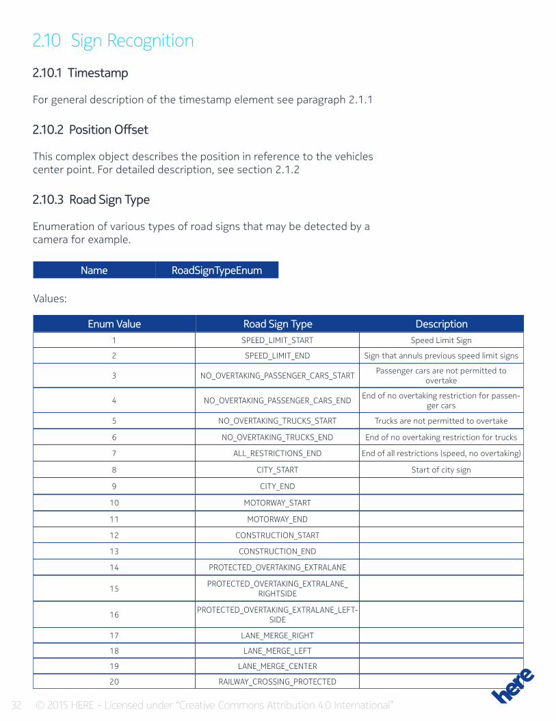
2.10 Sign Recognition
2.10.1 Timestamp
For general description of the timestamp element see paragraph 2.1.1
2.10.2 Position Offset
This complex object describes the position in reference to the vehicles center point. For detailed description, see section 2.1.2
2.10.3 Road Sign Type
Enumeration of various types of road signs that may be detected by a camera for example.
1
2
3
4
5
6
7
8
9
10
11
12
13
14
15
16
17
18
19
20
SPEED_LIMIT_START
SPEED_LIMIT_END
NO_OVERTAKING_PASSENGER_CARS_START
NO_OVERTAKING_PASSENGER_CARS_END
NO_OVERTAKING_TRUCKS_START
NO_OVERTAKING_TRUCKS_END
ALL_RESTRICTIONS_END
CITY_START
CITY_END
MOTORWAY_START
MOTORWAY_END
CONSTRUCTION_START
CONSTRUCTION_END
PROTECTED_OVERTAKING_EXTRALANE
PROTECTED_OVERTAKING_EXTRALANE_RIGHTSIDE
PROTECTED_OVERTAKING_EXTRALANE_LEFT-SIDE
LANE_MERGE_RIGHT
LANE_MERGE_LEFT
LANE_MERGE_CENTER
RAILWAY_CROSSING_PROTECTED
Speed Limit Sign
Sign that annuls previous speed limit signs
Passenger cars are not permitted to overtake
End of no overtaking restriction for passen-ger cars
Trucks are not permitted to overtake
End of no overtaking restriction for trucks
End of all restrictions (speed, no overtaking)
Start of city sign
Enum Value Road Sign Type Description
Name RoadSignTypeEnum
Values:
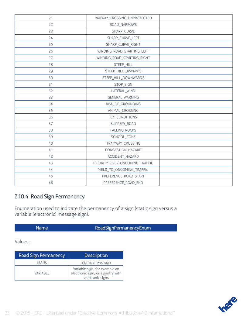
33 © 2015 HERE - Licensed under “Creative Commons Attribution 4.0 International”
21
22
23
24
25
26
27
28
29
30
31
32
33
34
35
36
37
38
39
40
41
42
43
44
45
46
STATIC
VARIABLE
Sign is a fixed sign
Variable sign, for example an electronic sign, or a gantry with
electronic signs
RAILWAY_CROSSING_UNPROTECTED
ROAD_NARROWS
SHARP_CURVE
SHARP_CURVE_LEFT
SHARP_CURVE_RIGHT
WINDING_ROAD_STARTING_LEFT
WINDING_ROAD_STARTING_RIGHT
STEEP_HILL
STEEP_HILL_UPWARDS
STEEP_HILL_DOWNWARDS
STOP_SIGN
LATERAL_WIND
GENERAL_WARNING
RISK_OF_GROUNDING
ANIMAL_CROSSING
ICY_CONDITIONS
SLIPPERY_ROAD
FALLING_ROCKS
SCHOOL_ZONE
TRAMWAY_CROSSING
CONGESTION_HAZARD
ACCIDENT_HAZARD
PRIORITY_OVER_ONCOMING_TRAFFIC
YIELD_TO_ONCOMING_TRAFFIC
PREFERENCE_ROAD_START
PREFERENCE_ROAD_END
2.10.4 Road Sign Permanency
Enumeration used to indicate the permanency of a sign (static sign versus a variable (electronic) message sign).
Name
Road Sign Permanency Description
RoadSignPermanencyEnum
Values:
34 © 2015 HERE - Licensed under “Creative Commons Attribution 4.0 International”
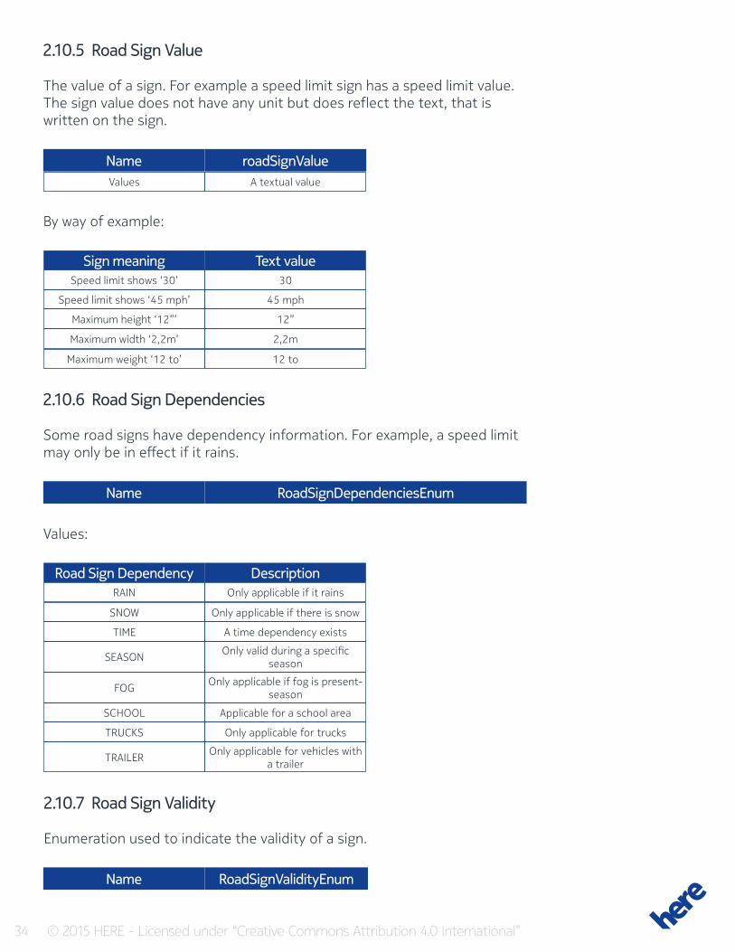
2.10.5 Road Sign Value
The value of a sign. For example a speed limit sign has a speed limit value. The sign value does not have any unit but does reflect the text, that is written on the sign.
Values
Sign meaning
Road Sign Dependency
Speed limit shows ‘30’
RAIN
SNOW
TIME
SEASON
FOG
SCHOOL
TRUCKS
TRAILER
Speed limit shows ‘45 mph’
Maximum height ‘12”’
Maximum width ‘2,2m’
Maximum weight ‘12 to’
A textual value
Text value
Description
30
Only applicable if it rains
Only applicable if there is snow
A time dependency exists
Only valid during a specific season
Only applicable if fog is present-season
Applicable for a school area
Only applicable for trucks
Only applicable for vehicles with a trailer
45 mph
12”
2,2m
12 to
Name
Name
Name
roadSignValue
RoadSignDependenciesEnum
RoadSignValidityEnum
By way of example:
2.10.6 Road Sign Dependencies
Some road signs have dependency information. For example, a speed limit may only be in effect if it rains.
Values:
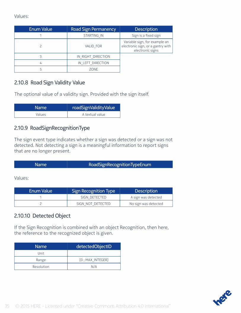
2.10.7 Road Sign Validity
Enumeration used to indicate the validity of a sign.
35 © 2015 HERE - Licensed under “Creative Commons Attribution 4.0 International”
Road Sign PermanencyEnum ValueSTARTING_IN1
VALID_FOR
IN_RIGHT_DIRECTION
IN_LEFT_DIRECTION
ZONE
2
3
4
5
DescriptionSign is a fixed sign
Variable sign, for example an electronic sign, or a gantry with
electronic signs
Values:
2.10.8 Road Sign Validity Value
The optional value of a validity sign. Provided with the sign itself.
Values A textual value
Name
Name
roadSignValidityValue
RoadSignRecognitionTypeEnum
2.10.9 RoadSignRecognitionType
The sign event type indicates whether a sign was detected or a sign was not detected. Not detecting a sign is a meaningful information to report signs that are no longer present.
Sign Recognition TypeEnum ValueSIGN_DETECTED
SIGN_NOT_DETECTED
1
2
DescriptionA sign was detected
No sign was detected
Values:
2.10.10 Detected Object
If the Sign Recognition is combined with an object Recognition, then here, the reference to the recognized object is given.
Name detectedObjectIDUnit
Range
Resolution
[0 ; MAX_INTEGER]
N/A
36 © 2015 HERE - Licensed under “Creative Commons Attribution 4.0 International”
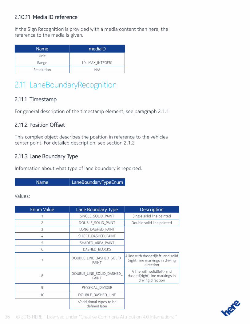
2.10.11 Media ID reference
If the Sign Recognition is provided with a media content then here, the reference to the media is given.
Name mediaIDUnit
Range
Resolution
[0 ; MAX_INTEGER]
N/A
2.11 LaneBoundaryRecognition
2.11.1 Timestamp
For general description of the timestamp element, see paragraph 2.1.1
2.11.2 Position Offset
This complex object describes the position in reference to the vehicles center point. For detailed description, see section 2.1.2
2.11.3 Lane Boundary Type
Information about what type of lane boundary is reported.
Name LaneBoundaryTypeEnum
Lane Boundary TypeEnum ValueSINGLE_SOLID_PAINT
DOUBLE_SOLID_PAINT
DOUBLE_LINE_DASHED_SOLID_PAINT
DOUBLE_LINE_SOLID_DASHED_PAINT
PHYSICAL_DIVIDER
DOUBLE_DASHED_LINE
//additional types to be defined later
LONG_DASHED_PAINT
SHORT_DASHED_PAINT
SHADED_AREA_PAINT
DASHED_BLOCKS
1
2
7
8
9
10
3
4
5
6
DescriptionSingle solid line painted
Double solid line painted
A line with dashed(left) and solid (right) line markings in driving
direction
A line with solid(left) and dashed(right) line markings in
driving direction
Values:
37 © 2015 HERE - Licensed under “Creative Commons Attribution 4.0 International”
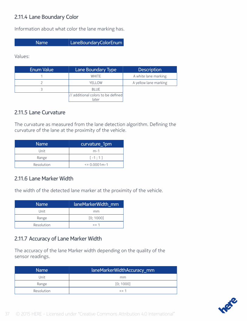
2.11.4 Lane Boundary Color
Information about what color the lane marking has.
Name LaneBoundaryColorEnum
Lane Boundary TypeEnum ValueWHITE
YELLOW
BLUE
// additional colors to be defined later
1
2
3
DescriptionA white lane marking
A yellow lane marking
Values:
2.11.5 Lane Curvature
The curvature as measured from the lane detection algorithm. Defining the curvature of the lane at the proximity of the vehicle.
Name
Name
Name
curvature_1pm
laneMarkerWidth_mm
laneMarkerWidthAccuracy_mm
Unit
Unit
Unit
Range
Range
Range
Resolution
Resolution
Resolution
m-1
mm
mm
[ -1 ; 1 ]
[0; 1000]
[0; 1000]
<= 0.0001m-1
== 1
== 1
2.11.6 Lane Marker Width
the width of the detected lane marker at the proximity of the vehicle.
2.11.7 Accuracy of Lane Marker Width
The accuracy of the lane Marker width depending on the quality of the sensor readings.
38 © 2015 HERE - Licensed under “Creative Commons Attribution 4.0 International”
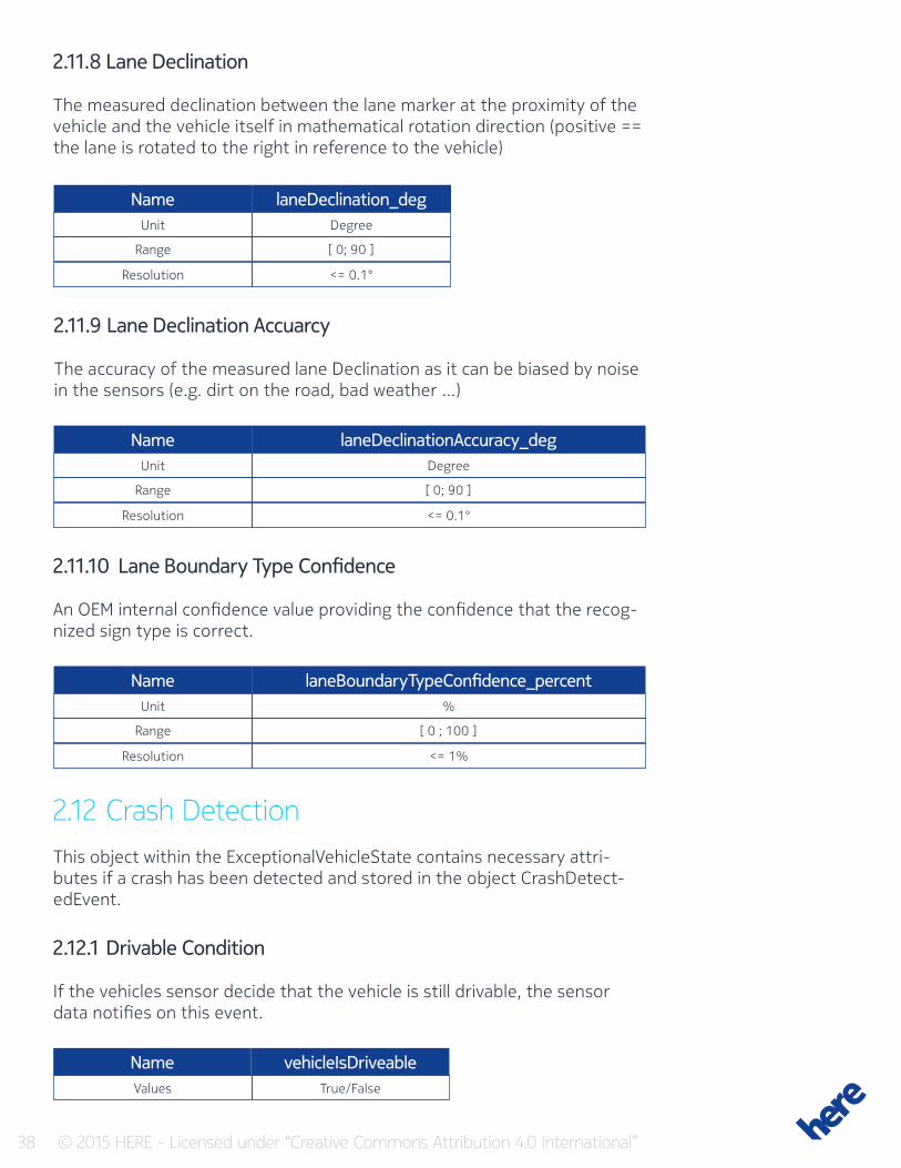
2.11.8 Lane Declination
The measured declination between the lane marker at the proximity of the vehicle and the vehicle itself in mathematical rotation direction (positive == the lane is rotated to the right in reference to the vehicle)
Name
Name
Name
laneDeclination_deg
laneDeclinationAccuracy_deg
laneBoundaryTypeConfidence_percent
Unit
Unit
Unit
Range
Range
Range
Resolution
Resolution
Resolution
Degree
Degree
%
[ 0; 90 ]
[ 0; 90 ]
[ 0 ; 100 ]
<= 0.1°
<= 0.1°
<= 1%
2.11.9 Lane Declination Accuarcy
The accuracy of the measured lane Declination as it can be biased by noise in the sensors (e.g. dirt on the road, bad weather …)
2.11.10 Lane Boundary Type Confidence
An OEM internal confidence value providing the confidence that the recog-nized sign type is correct.
2.12 Crash DetectionThis object within the ExceptionalVehicleState contains necessary attri-butes if a crash has been detected and stored in the object CrashDetect-edEvent.
2.12.1 Drivable Condition
If the vehicles sensor decide that the vehicle is still drivable, the sensor data notifies on this event.
Values True/False
Name vehicleIsDriveable
39 © 2015 HERE - Licensed under “Creative Commons Attribution 4.0 International”
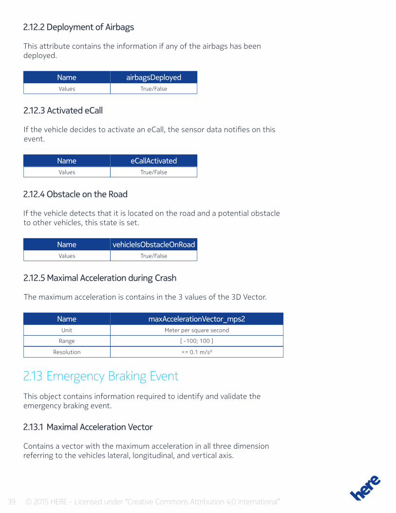
2.12.2 Deployment of Airbags
This attribute contains the information if any of the airbags has been deployed.
Values
Values
Values
True/False
True/False
True/False
Name
Name
Name
airbagsDeployed
eCallActivated
vehicleIsObstacleOnRoad
2.12.3 Activated eCall
If the vehicle decides to activate an eCall, the sensor data notifies on this event.
2.12.4 Obstacle on the Road
If the vehicle detects that it is located on the road and a potential obstacle to other vehicles, this state is set.
2.12.5 Maximal Acceleration during Crash
The maximum acceleration is contains in the 3 values of the 3D Vector.
Name maxAccelerationVector_mps2Unit
Range
Resolution
Meter per square second
[ -100; 100 ]
<= 0.1 m/s²
2.13 Emergency Braking EventThis object contains information required to identify and validate the emergency braking event.
2.13.1 Maximal Acceleration Vector
Contains a vector with the maximum acceleration in all three dimension referring to the vehicles lateral, longitudinal, and vertical axis.
40 © 2015 HERE - Licensed under “Creative Commons Attribution 4.0 International”
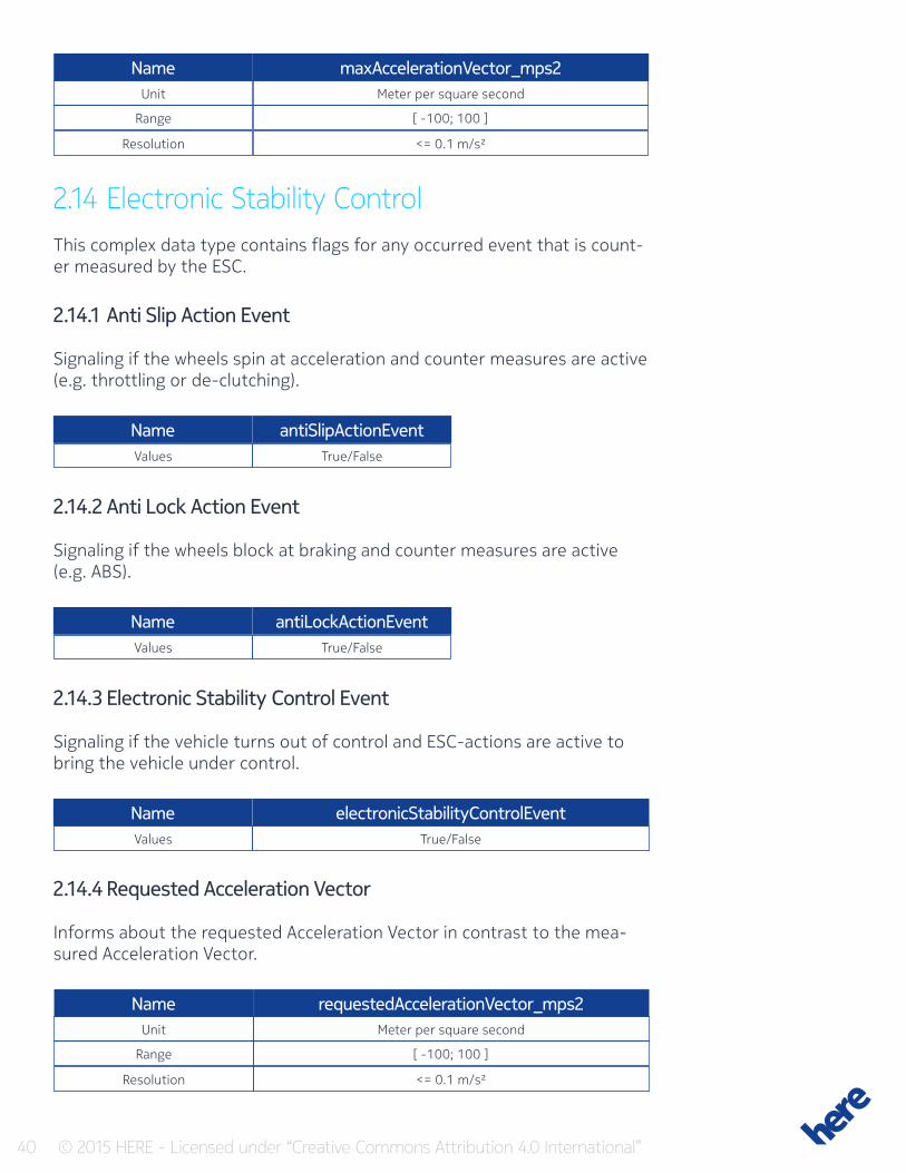
Name maxAccelerationVector_mps2Unit
Range
Resolution
Meter per square second
[ -100; 100 ]
<= 0.1 m/s²
2.14 Electronic Stability ControlThis complex data type contains flags for any occurred event that is count-er measured by the ESC.
2.14.1 Anti Slip Action Event
Signaling if the wheels spin at acceleration and counter measures are active (e.g. throttling or de-clutching).
Values
Values
Values
True/False
True/False
True/False
Name
Name
Name
antiSlipActionEvent
antiLockActionEvent
electronicStabilityControlEvent
2.14.2 Anti Lock Action Event
Signaling if the wheels block at braking and counter measures are active (e.g. ABS).
2.14.3 Electronic Stability Control Event
Signaling if the vehicle turns out of control and ESC-actions are active to bring the vehicle under control.
2.14.4 Requested Acceleration Vector
Informs about the requested Acceleration Vector in contrast to the mea-sured Acceleration Vector.
Name requestedAccelerationVector_mps2Unit
Range
Resolution
Meter per square second
[ -100; 100 ]
<= 0.1 m/s²
41 © 2015 HERE - Licensed under “Creative Commons Attribution 4.0 International”
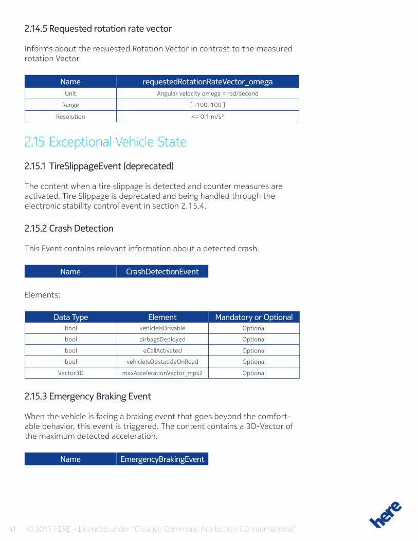
2.14.5 Requested rotation rate vector
Informs about the requested Rotation Vector in contrast to the measured rotation Vector
Name requestedRotationRateVector_omegaUnit
Range
Resolution
Angular velocity omega = rad/second
[ -100; 100 ]
<= 0.1 m/s²
2.15 Exceptional Vehicle State
2.15.1 TireSlippageEvent (deprecated)
The content when a tire slippage is detected and counter measures are activated. Tire Slippage is deprecated and being handled through the electronic stability control event in section 2.15.4.
2.15.2 Crash Detection
This Event contains relevant information about a detected crash.
Name
Name
CrashDetectionEvent
EmergencyBrakingEvent
Elements:
ElementData TypevehicleIsDrivable
airbagsDeployed
eCallActivated
vehicleIsObstackleOnRoad
maxAccelerationVector_mps2
bool
bool
bool
bool
Vector3D
Mandatory or OptionalOptional
Optional
Optional
Optional
Optional
2.15.3 Emergency Braking Event
When the vehicle is facing a braking event that goes beyond the comfort-able behavior, this event is triggered. The content contains a 3D-Vector of the maximum detected acceleration.
42 © 2015 HERE - Licensed under “Creative Commons Attribution 4.0 International”
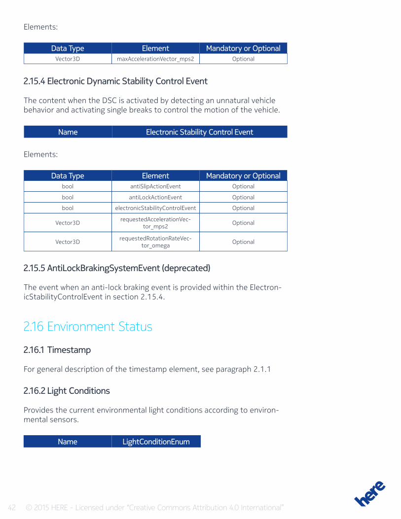
Elements:
Elements:
Element
Element
Data Type
Data Type
maxAccelerationVector_mps2
antiSlipActionEvent
antiLockActionEvent
electronicStabilityControlEvent
requestedAccelerationVec-tor_mps2
requestedRotationRateVec-tor_omega
Vector3D
bool
bool
bool
Vector3D
Vector3D
Mandatory or Optional
Mandatory or Optional
Optional
Optional
Optional
Optional
Optional
Optional
2.15.4 Electronic Dynamic Stability Control Event
The content when the DSC is activated by detecting an unnatural vehicle behavior and activating single breaks to control the motion of the vehicle.
Name Electronic Stability Control Event
2.15.5 AntiLockBrakingSystemEvent (deprecated)
The event when an anti-lock braking event is provided within the Electron-icStabilityControlEvent in section 2.15.4.
2.16 Environment Status
2.16.1 Timestamp
For general description of the timestamp element, see paragraph 2.1.1
2.16.2 Light Conditions
Provides the current environmental light conditions according to environ-mental sensors.
Name LightConditionEnum
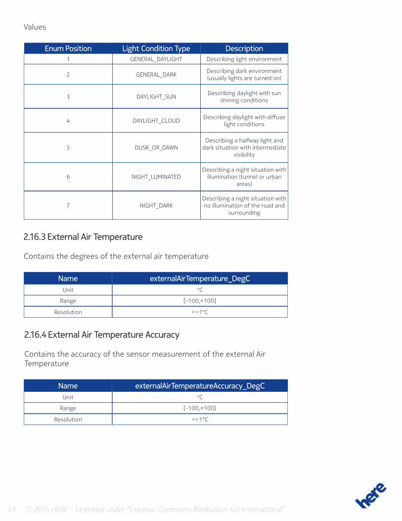
43 © 2015 HERE - Licensed under “Creative Commons Attribution 4.0 International”
Values
Light Condition TypeEnum PositionGENERAL_DAYLIGHT
GENERAL_DARK
DAYLIGHT_SUN
DAYLIGHT_CLOUD
DUSK_OR_DAWN
NIGHT_LUMINATED
NIGHT_DARK
1
2
3
4
5
6
7
DescriptionDescribing light environment
Describing dark environment (usually lights are turned on)
Describing daylight with sun shining conditions
Describing daylight with diffuse light conditions
Describing a halfway light and dark situation with intermediate
visibility
Describing a night situation with illumination (tunnel or urban
areas)
Describing a night situation with no illumination of the road and
surrounding
2.16.3 External Air Temperature
Contains the degrees of the external air temperature
Name
Name
externalAirTemperature_DegC
externalAirTemperatureAccuracy_DegC
Unit
Unit
Range
Range
Resolution
Resolution
°C
°C
[-100,+100]
[-100,+100]
<=1°C
<=1°C
2.16.4 External Air Temperature Accuracy
Contains the accuracy of the sensor measurement of the external Air Temperature
44 © 2015 HERE - Licensed under “Creative Commons Attribution 4.0 International”
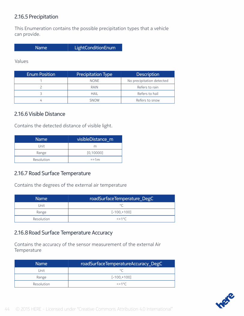
2.16.5 Precipitation
This Enumeration contains the possible precipitation types that a vehicle can provide.
Name LightConditionEnum
Values
Precipitation TypeEnum PositionNONE
RAIN
HAIL
SNOW
1
2
3
4
DescriptionNo precipitation detected
Refers to rain
Refers to hail
Refers to snow
2.16.6 Visible Distance
Contains the detected distance of visible light.
Name
Name
Name
visibleDistance_m
roadSurfaceTemperature_DegC
roadSurfaceTemperatureAccuracy_DegC
Unit
Unit
Unit
Range
Range
Range
Resolution
Resolution
Resolution
m
°C
°C
[0,10000]
[-100,+100]
[-100,+100]
==1m
<=1°C
<=1°C
2.16.7 Road Surface Temperature
Contains the degrees of the external air temperature
2.16.8 Road Surface Temperature Accuracy
Contains the accuracy of the sensor measurement of the external Air Temperature
45 © 2015 HERE - Licensed under “Creative Commons Attribution 4.0 International”
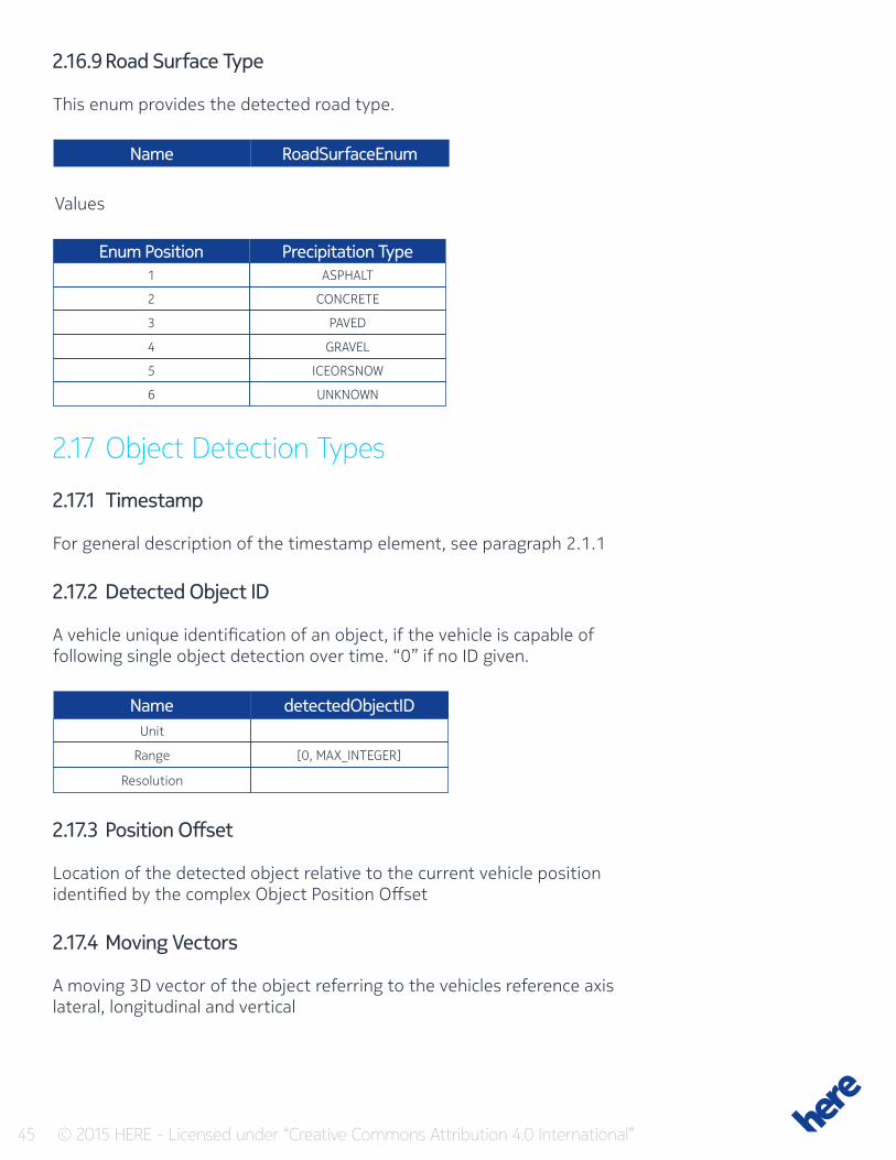
2.16.9 Road Surface Type
This enum provides the detected road type.
Name RoadSurfaceEnum
Values
Precipitation TypeEnum PositionASPHALT
CONCRETE
PAVED
GRAVEL
ICEORSNOW
UNKNOWN
1
2
3
4
5
6
2.17 Object Detection Types
2.17.1 Timestamp
For general description of the timestamp element, see paragraph 2.1.1
2.17.2 Detected Object ID
A vehicle unique identification of an object, if the vehicle is capable of following single object detection over time. “0” if no ID given.
Name detectedObjectIDUnit
Range
Resolution
[0, MAX_INTEGER]
2.17.3 Position Offset
Location of the detected object relative to the current vehicle position identified by the complex Object Position Offset
2.17.4 Moving Vectors
A moving 3D vector of the object referring to the vehicles reference axis lateral, longitudinal and vertical
46 © 2015 HERE - Licensed under “Creative Commons Attribution 4.0 International”
Name movingVector_mps
Unit
Range
Resolution
3 dimensional vector of speeds in meter per second
3*[-1000;+1000]
<= 1
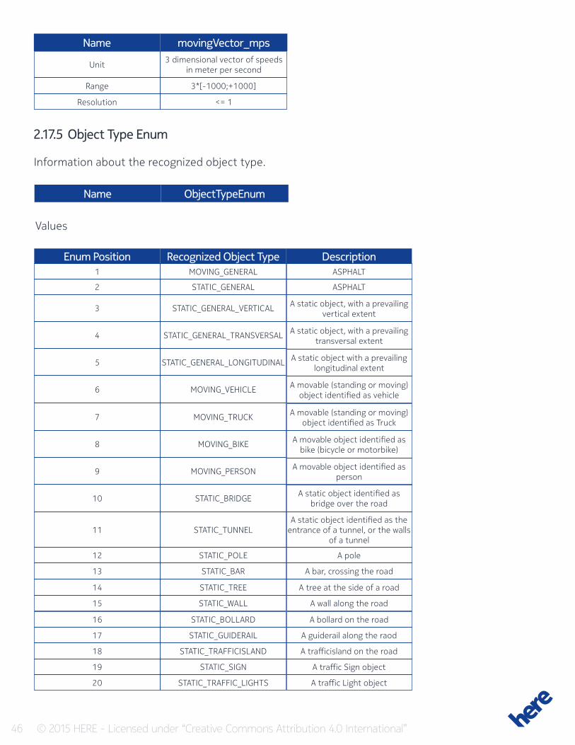
2.17.5 Object Type Enum
Information about the recognized object type.
Name ObjectTypeEnum
Values
Recognized Object TypeEnum PositionMOVING_GENERAL ASPHALT
ASPHALT
A static object, with a prevailing vertical extent
A static object, with a prevailing transversal extent
A static object with a prevailing longitudinal extent
A movable (standing or moving) object identified as vehicle
A movable (standing or moving) object identified as Truck
A movable object identified as bike (bicycle or motorbike)
A movable object identified as person
A static object identified as bridge over the road
A static object identified as the entrance of a tunnel, or the walls
of a tunnel
A pole
A bar, crossing the road
A tree at the side of a road
A wall along the road
A bollard on the road
A guiderail along the raod
A trafficisland on the road
A traffic Sign object
A traffic Light object
STATIC_GENERAL
STATIC_GENERAL_VERTICAL
STATIC_GENERAL_TRANSVERSAL
STATIC_GENERAL_LONGITUDINAL
MOVING_VEHICLE
MOVING_TRUCK
MOVING_BIKE
MOVING_PERSON
STATIC_BRIDGE
STATIC_TUNNEL
STATIC_POLE
STATIC_BAR
STATIC_TREE
STATIC_WALL
STATIC_BOLLARD
STATIC_GUIDERAIL
STATIC_TRAFFICISLAND
STATIC_SIGN
STATIC_TRAFFIC_LIGHTS
1
2
3
4
5
6
7
8
9
10
11
12
13
14
15
16
17
18
19
20
Description
47 © 2015 HERE - Licensed under “Creative Commons Attribution 4.0 International”
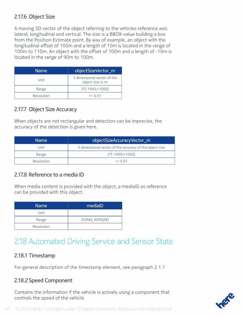
2.17.6 Object Size
A moving 3D vector of the object referring to the vehicles reference axis lateral, longitudinal and vertical. The size is a BBOX-value building a box from the Position Estimate point. By way of example, an object with the longitudinal offset of 100m and a length of 10m is located in the range of 100m to 110m. An object with the offset of 100m and a length of -10m is located in the range of 90m to 100m.
Name
Name
Name
objectSizeVector_m
objectSizeAccuracyVector_m
mediaID
Unit
Unit
Unit
Range
Range
Range
Resolution
Resolution
Resolution
3 dimensional vector of the object size in m
3 dimensional vector of the accuracy of the object size
3*[-1000;+1000]
3*[-1000;+1000]
[0;MAX_INTEGER]
<= 0.01
<= 0.01
2.17.7 Object Size Accuracy
When objects are not rectangular and detection can be imprecise, the accuracy of the detection is given here.
2.17.8 Reference to a media ID
When media content is provided with the object, a mediaID as reference can be provided with this object.
2.18 Automated Driving Service and Sensor State
2.18.1 Timestamp
For general description of the timestamp element, see paragraph 2.1.1
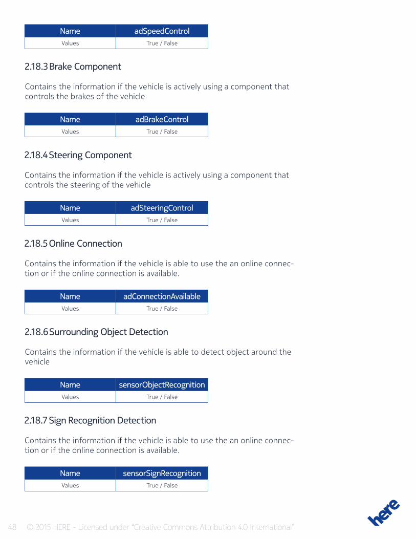
2.18.2 Speed Component
Contains the information if the vehicle is actively using a component that controls the speed of the vehicle
48 © 2015 HERE - Licensed under “Creative Commons Attribution 4.0 International”
Name
Name
Name
Name
Name
Name
adSpeedControl
adBrakeControl
adSteeringControl
adConnectionAvailable
sensorObjectRecognition
sensorSignRecognition
Values
Values
Values
Values
Values
Values
True / False
True / False
True / False
True / False
True / False
True / False
2.18.3 Brake Component
Contains the information if the vehicle is actively using a component that controls the brakes of the vehicle
2.18.4 Steering Component
Contains the information if the vehicle is actively using a component that controls the steering of the vehicle
2.18.5 Online Connection
Contains the information if the vehicle is able to use the an online connec-tion or if the online connection is available.
2.18.6 Surrounding Object Detection
Contains the information if the vehicle is able to detect object around the vehicle
2.18.7 Sign Recognition Detection
Contains the information if the vehicle is able to use the an online connec-tion or if the online connection is available.
49 © 2015 HERE - Licensed under “Creative Commons Attribution 4.0 International”
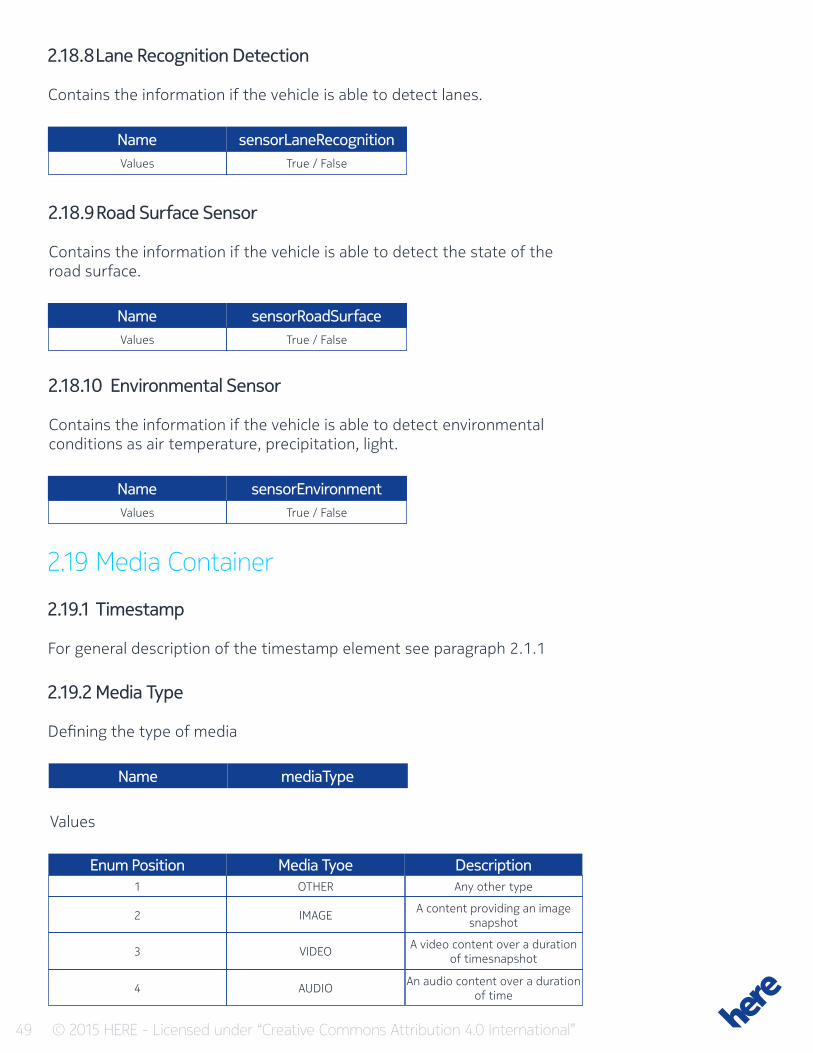
2.18.8 Lane Recognition Detection
Contains the information if the vehicle is able to detect lanes.
Name
Name
Name
sensorLaneRecognition
sensorRoadSurface
sensorEnvironment
Values
Values
Values
True / False
True / False
True / False
2.18.9 Road Surface Sensor
Contains the information if the vehicle is able to detect the state of the road surface.
2.18.10 Environmental Sensor
Contains the information if the vehicle is able to detect environmental conditions as air temperature, precipitation, light.
2.19 Media Container
2.19.1 Timestamp
For general description of the timestamp element see paragraph 2.1.1
2.19.2 Media Type
Defining the type of media
Name mediaType
Values
Media TyoeEnum PositionOTHER
IMAGE
VIDEO
AUDIO
Any other type
A content providing an image snapshot
A video content over a duration of timesnapshot
An audio content over a duration of time
1
2
3
4
Description
50 © 2015 HERE - Licensed under “Creative Commons Attribution 4.0 International”
2.19.3 MediaFormat
Contains information about the Media Format in text form (e.g. JPG)
Name
Name
Name
mediaFormat
mediaContent
mediaID
Values
Values
Values
String
Binary
int64
2.19.4 MediaContent
The data content
2.19.5 MediaID
Identifies the media throughout all media contents and allows to reference a media from other events as e.g. Object recognition.
2.19.6 SensorOffset
The position offset of the vehicles sensor to the vehicles reference point (center of the vehicle)
2.19.7 Sensor Direction
A vector defining the direction of the sensor view in relation to the vehicle.
2.19.8 Media Content Duration
If the media content is a video or anything similar then the duration of the media is contained in this attribute
Name duration_sUnit
Range
Resolution
Seconds
[0;+86400]
= 1
51 © 2015 HERE - Licensed under “Creative Commons Attribution 4.0 International”
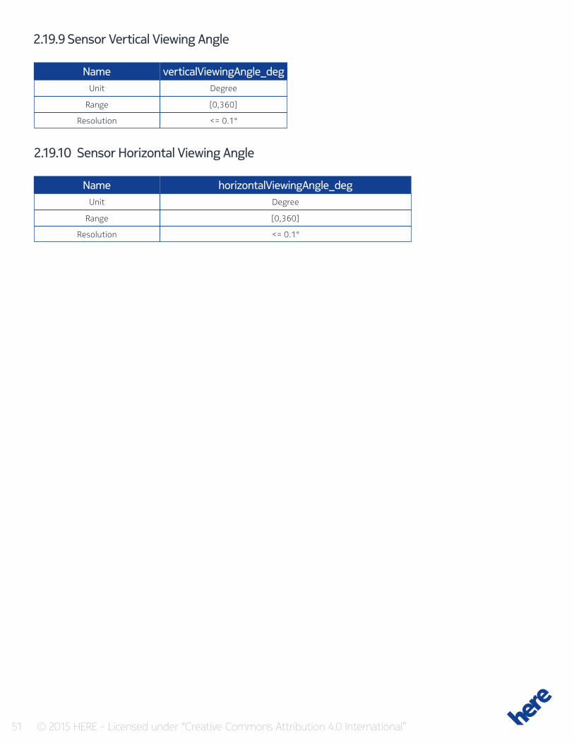
2.19.9 Sensor Vertical Viewing Angle
Name
Name
verticalViewingAngle_deg
horizontalViewingAngle_deg
Unit
Unit
Range
Range
Resolution
Resolution
Degree
Degree
[0,360]
[0,360]
<= 0.1°
<= 0.1°
2.19.10 Sensor Horizontal Viewing Angle
52 © 2015 HERE - Licensed under “Creative Commons Attribution 4.0 International”
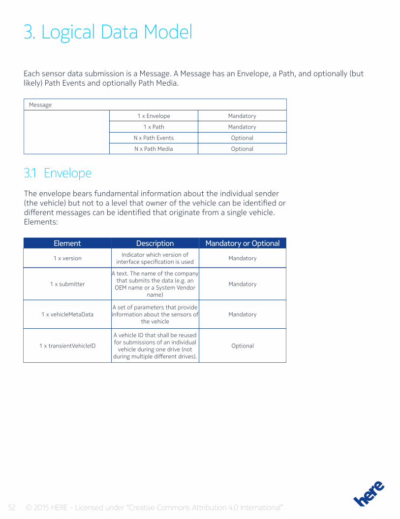
3. Logical Data Model
Each sensor data submission is a Message. A Message has an Envelope, a Path, and optionally (but likely) Path Events and optionally Path Media.
Message
Mandatory
Optional
Mandatory
Optional
1 x Envelope
N x Path Events
1 x Path
N x Path Media
3.1 EnvelopeThe envelope bears fundamental information about the individual sender (the vehicle) but not to a level that owner of the vehicle can be identified or different messages can be identified that originate from a single vehicle.Elements:
DescriptionElementIndicator which version of
interface specification is used
A text. The name of the company that submits the data (e.g. an
OEM name or a System Vendor name)
A set of parameters that provide information about the sensors of
the vehicle
A vehicle ID that shall be reused for submissions of an individual
vehicle during one drive (not during multiple different drives).
Mandatory
Mandatory
Mandatory
Optional
1 x version
1 x submitter
1 x vehicleMetaData
1 x transientVehicleID
Mandatory or Optional
53 © 2015 HERE - Licensed under “Creative Commons Attribution 4.0 International”
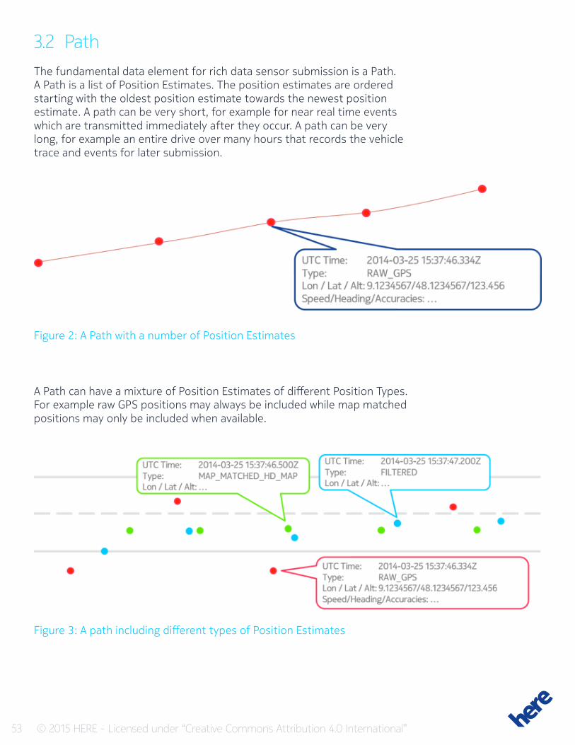
3.2 PathThe fundamental data element for rich data sensor submission is a Path.A Path is a list of Position Estimates. The position estimates are ordered starting with the oldest position estimate towards the newest position estimate. A path can be very short, for example for near real time events which are transmitted immediately after they occur. A path can be very long, for example an entire drive over many hours that records the vehicle trace and events for later submission.
Figure 2: A Path with a number of Position Estimates
Figure 3: A path including different types of Position Estimates
A Path can have a mixture of Position Estimates of different Position Types. For example raw GPS positions may always be included while map matched positions may only be included when available.
54 © 2015 HERE - Licensed under “Creative Commons Attribution 4.0 International”
A Path must have at least one Position Estimate.
Elements:
DescriptionElementThe list of position estimates
that make up the path MandatoryN xPositionEstimate
Mandatory or Optional
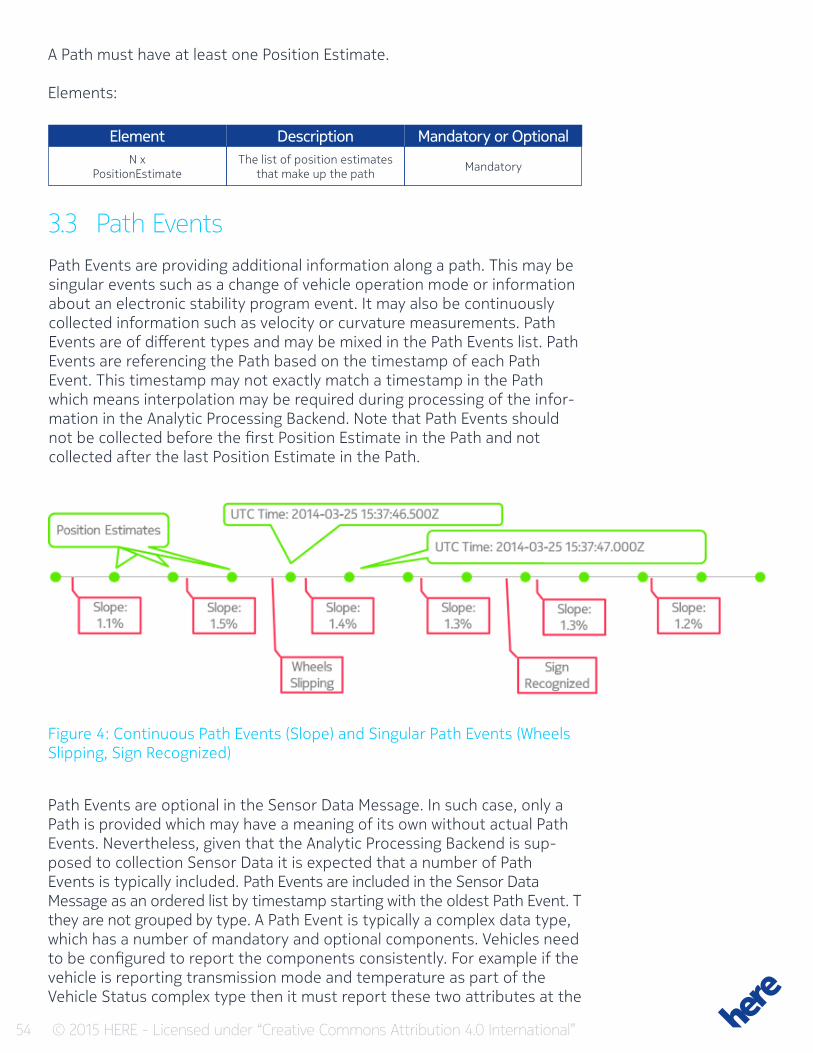
3.3 Path EventsPath Events are providing additional information along a path. This may be singular events such as a change of vehicle operation mode or information about an electronic stability program event. It may also be continuously collected information such as velocity or curvature measurements. Path Events are of different types and may be mixed in the Path Events list. Path Events are referencing the Path based on the timestamp of each Path Event. This timestamp may not exactly match a timestamp in the Path which means interpolation may be required during processing of the infor-mation in the Analytic Processing Backend. Note that Path Events should not be collected before the first Position Estimate in the Path and not collected after the last Position Estimate in the Path.
Figure 4: Continuous Path Events (Slope) and Singular Path Events (Wheels Slipping, Sign Recognized)
Path Events are optional in the Sensor Data Message. In such case, only a Path is provided which may have a meaning of its own without actual Path Events. Nevertheless, given that the Analytic Processing Backend is sup-posed to collection Sensor Data it is expected that a number of Path Events is typically included. Path Events are included in the Sensor Data Message as an ordered list by timestamp starting with the oldest Path Event. T they are not grouped by type. A Path Event is typically a complex data type, which has a number of mandatory and optional components. Vehicles need to be configured to report the components consistently. For example if the vehicle is reporting transmission mode and temperature as part of the Vehicle Status complex type then it must report these two attributes at the
55 © 2015 HERE - Licensed under “Creative Commons Attribution 4.0 International”
very beginning of the path initially. Whenever the transmission mode is changing, another Path Event must be reported that indicates the new transmission mode value in the Vehicle Status complex type. Whenever temperature is changing, another Path Event must be reported that indi-cates the new temperature value in the Vehicle Status complex type. If by chance two Path Events are reported at the exact same timestamp, then all Information can be merged into one combined Path Events, as long as both events do not have conflicting information.
DescriptionElementVehicle status has various
elements describing the status of the vehicle.
Vehicle dynamics has various elements describing the dynamic
movements of the vehicle. Vehicle Dynamics Path Events
may be present at a much higher frequency than any other event
and also at higher frequency than Position Estimates
Information about a recognized (or missing) road sign
Information about a recognized lane boundary
Information about an exceptional vehicle state
OEM specific proprietary data typically only used by Platform as
a Service customers
Information about the environ-ment
Identified position of objects (moving or static)
Information about the activated Sensors and Controls for AD-feature of the vehicle
Information about fuel state
Optional
Optional
Optional
Optional
Optional
Optional
Optional
Optional
Optional
Optional
N1 x VehicleStatus
N2 x VehicleDynamics
N3 x SignRecognition
N4 x LaneBoundaryRecognition
N5 x ExceptionalVehicleState
N6 x ProprietaryInfo
N7 x EnvironmentStatus
N8 x ObjectDetection
N9 x ADSensorAndServiceState
N9 x Fuel Event
Mandatory or Optional
56 © 2015 HERE - Licensed under “Creative Commons Attribution 4.0 International”
3.4 Path MediaPath Media are providing additional media content along a path. It may be collected information referring to a certain Path Events, but also may be content requested at a certain location by vehicle or backend configura-tion. Similar to Path Events, Path Media does contain a repeated amount of Media Container. Each Container can hold exactly one media as e.g. an Image or a Video-Clip of an image sensor.
DescriptionElementmediaContainer OptionalN1 x MediaContainer
Mandatory or Optional
57 © 2015 HERE - Licensed under “Creative Commons Attribution 4.0 International”
4 Submission Considerations
Vehicles may have different collection policies for different types of sensor data. According to individual priorities of Sensor Data information, a mes-sage could be compiled and sent out the moment a specific Sensor Data reading is detected or the events could be accumulated into one Message and submitted after a given amount of time. By way of example, this could be due to reducing computational performance in critical moments while driving, due to reduction of transmission volume through cell phone con-nection or due to accumulation and thus referencing all detected Path Events onto one single path. The latter case may be given if the referencing of multiple Path Events to one single vehicle is needed and the usage of Transient Vehicle ID is not supported or not wished.The following sections provide implementation guidance for different collection policies.
4.1 Delayed / Batch SubmissionFor delayed submission, it is recommended to record Position Estimates during the entire drive. Should there be a need for gaps in the path for privacy reasons then it is important to separate the individual parts before and after the gap completely. The part after a gap should be treated as a completely new path and therefore collected in a separate submission.Some of the data elements are added to a path when a change occurs. For example, if the status of the vehicle lights changes then a Vehicle Status Path Event should be added describing the new status. At the beginning of a path, such information also must be provided as initialization indepen-dent whether the information just changed. This information would be added at the beginning of the path as Path Event. For delayed submission, some of the data elements described in this document may seem to be not important to be included. However, if not already provided as near real time submission it may be required to include these data also into batch sub-missions as the data can be required by analyze processes By way of exam-ple it may be useful to identify areas where certain events happen frequently.
4.2 Near Real Time SubmissionFor near real time submissions the paths may be very short. Such submis-sions are triggered by events in the vehicle that result in the creation of a specific Path Event. For example, a speed limit sign may be recognized which results in the creation of a Sign Recognition Path Event. This may result in the need of an instant submission of this information from the vehicle to the OEM / System Vendor backend to the Analytics Processing Cloud.

58 © 2015 HERE - Licensed under “Creative Commons Attribution 4.0 International”
In such cases a short Path must be included which is referenced by the Path Event(s). This Path should start at least 10 Position Estimates and at a minimum 100m before the actual event and should include 2 Position Estimates after the event. For such small Paths it is also important that at the beginning of the Path all other Path Events are included that describe the status of the vehicle and that are supplied during at least one Sensor Data Submission, independent whether the information changed or not.

59 © 2015 HERE - Licensed under “Creative Commons Attribution 4.0 International”
5 Encoding
Messages are encoded using specific serialization mechanisms. The prima-ry mechanism is Protocol Buffers. The Protocol Buffer definitions are avail-able as a separate *.proto file. A binary encoded Protocol Buffer example file is available.
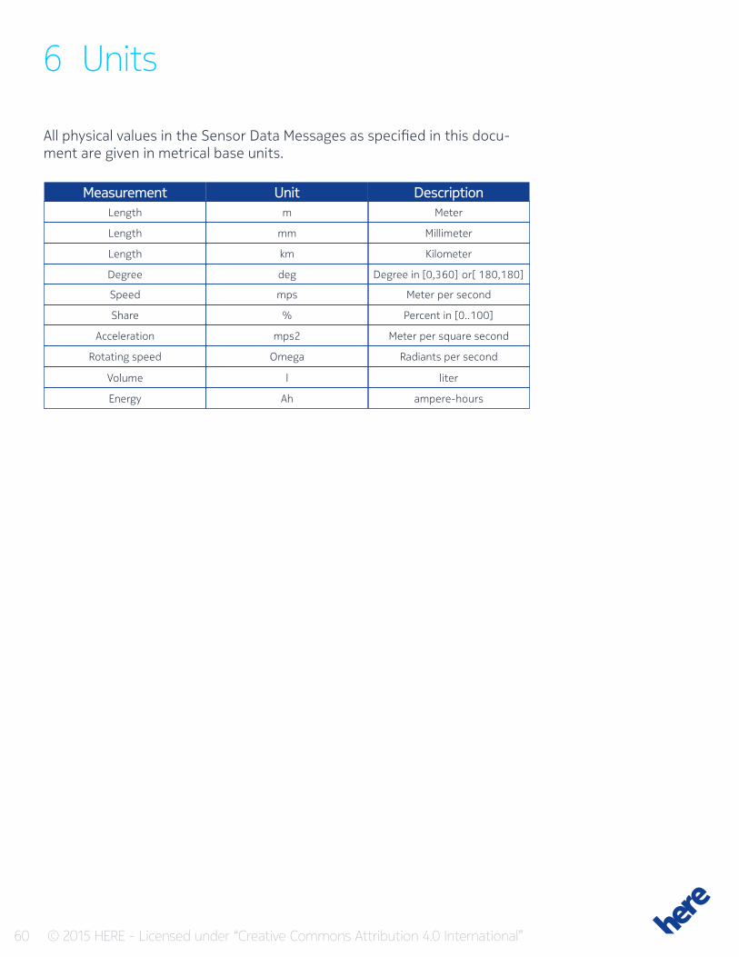
60 © 2015 HERE - Licensed under “Creative Commons Attribution 4.0 International”
6 Units
All physical values in the Sensor Data Messages as specified in this docu-ment are given in metrical base units.
UnitMeasurementm
mm
km
deg
mps
%
mps2
Omega
l
Ah
Meter
Millimeter
Kilometer
Degree in [0,360] or[ 180,180]
Meter per second
Percent in [0..100]
Meter per square second
Radiants per second
liter
ampere-hours
Length
Length
Length
Degree
Speed
Share
Acceleration
Rotating speed
Volume
Energy
Description
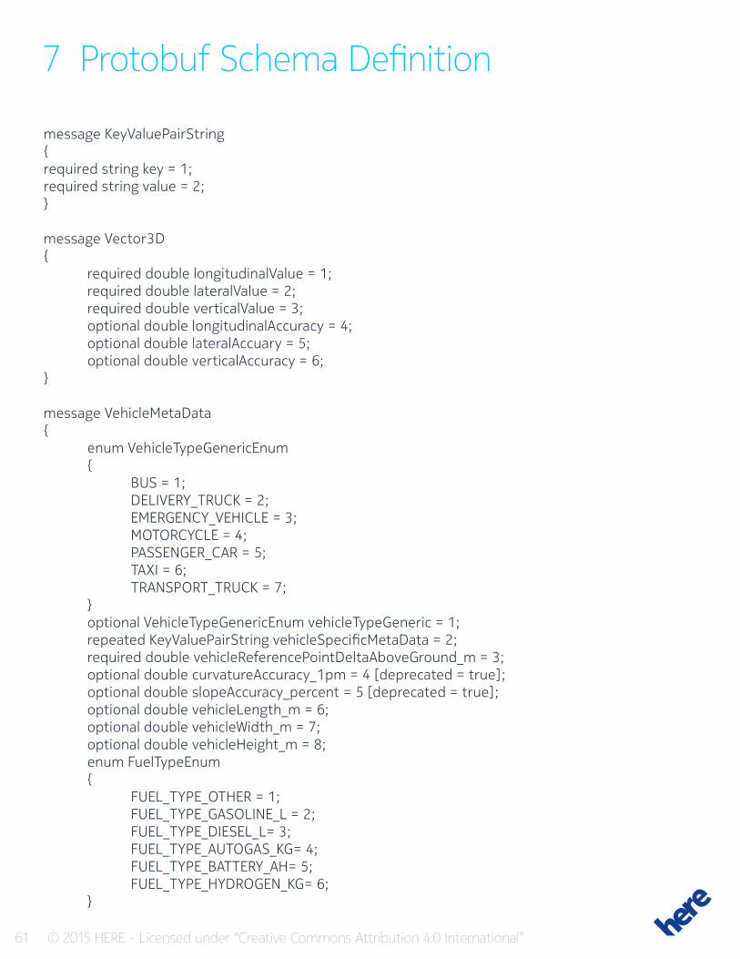
61 © 2015 HERE - Licensed under “Creative Commons Attribution 4.0 International”
7 Protobuf Schema Definition
message KeyValuePairString{required string key = 1;required string value = 2;}
message Vector3D{ required double longitudinalValue = 1; required double lateralValue = 2; required double verticalValue = 3; optional double longitudinalAccuracy = 4; optional double lateralAccuary = 5; optional double verticalAccuracy = 6;}
message VehicleMetaData{ enum VehicleTypeGenericEnum { BUS = 1; DELIVERY_TRUCK = 2; EMERGENCY_VEHICLE = 3; MOTORCYCLE = 4; PASSENGER_CAR = 5; TAXI = 6; TRANSPORT_TRUCK = 7; } optional VehicleTypeGenericEnum vehicleTypeGeneric = 1; repeated KeyValuePairString vehicleSpecificMetaData = 2; required double vehicleReferencePointDeltaAboveGround_m = 3; optional double curvatureAccuracy_1pm = 4 [deprecated = true]; optional double slopeAccuracy_percent = 5 [deprecated = true]; optional double vehicleLength_m = 6; optional double vehicleWidth_m = 7; optional double vehicleHeight_m = 8; enum FuelTypeEnum { FUEL_TYPE_OTHER = 1; FUEL_TYPE_GASOLINE_L = 2; FUEL_TYPE_DIESEL_L= 3; FUEL_TYPE_AUTOGAS_KG= 4; FUEL_TYPE_BATTERY_AH= 5; FUEL_TYPE_HYDROGEN_KG= 6; }
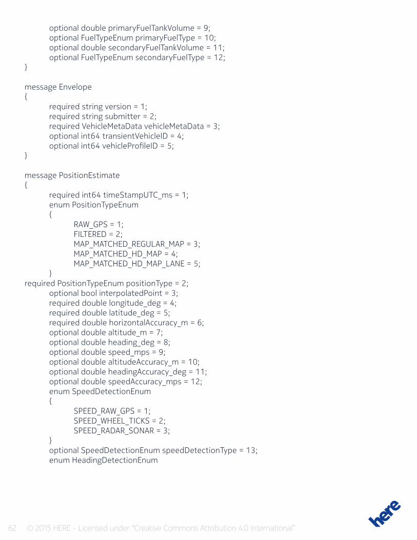
62 © 2015 HERE - Licensed under “Creative Commons Attribution 4.0 International”
optional double primaryFuelTankVolume = 9; optional FuelTypeEnum primaryFuelType = 10; optional double secondaryFuelTankVolume = 11; optional FuelTypeEnum secondaryFuelType = 12;}
message Envelope{ required string version = 1; required string submitter = 2; required VehicleMetaData vehicleMetaData = 3; optional int64 transientVehicleID = 4; optional int64 vehicleProfileID = 5;}
message PositionEstimate{ required int64 timeStampUTC_ms = 1; enum PositionTypeEnum { RAW_GPS = 1; FILTERED = 2; MAP_MATCHED_REGULAR_MAP = 3; MAP_MATCHED_HD_MAP = 4; MAP_MATCHED_HD_MAP_LANE = 5; }required PositionTypeEnum positionType = 2; optional bool interpolatedPoint = 3; required double longitude_deg = 4; required double latitude_deg = 5; required double horizontalAccuracy_m = 6; optional double altitude_m = 7; optional double heading_deg = 8; optional double speed_mps = 9; optional double altitudeAccuracy_m = 10; optional double headingAccuracy_deg = 11; optional double speedAccuracy_mps = 12; enum SpeedDetectionEnum { SPEED_RAW_GPS = 1; SPEED_WHEEL_TICKS = 2; SPEED_RADAR_SONAR = 3; } optional SpeedDetectionEnum speedDetectionType = 13; enum HeadingDetectionEnum
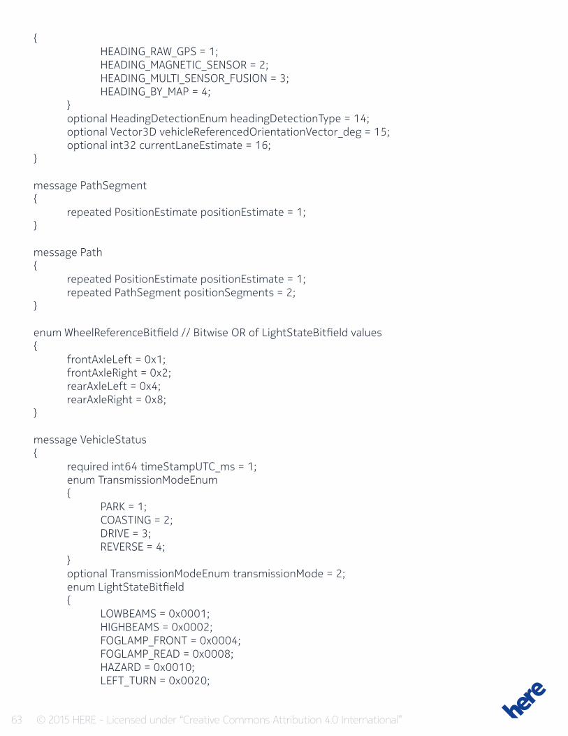
63 © 2015 HERE - Licensed under “Creative Commons Attribution 4.0 International”
{ HEADING_RAW_GPS = 1; HEADING_MAGNETIC_SENSOR = 2; HEADING_MULTI_SENSOR_FUSION = 3; HEADING_BY_MAP = 4; } optional HeadingDetectionEnum headingDetectionType = 14; optional Vector3D vehicleReferencedOrientationVector_deg = 15; optional int32 currentLaneEstimate = 16;}
message PathSegment{ repeated PositionEstimate positionEstimate = 1;}
message Path{ repeated PositionEstimate positionEstimate = 1; repeated PathSegment positionSegments = 2;}
enum WheelReferenceBitfield // Bitwise OR of LightStateBitfield values{ frontAxleLeft = 0x1; frontAxleRight = 0x2; rearAxleLeft = 0x4; rearAxleRight = 0x8;}
message VehicleStatus{ required int64 timeStampUTC_ms = 1; enum TransmissionModeEnum { PARK = 1; COASTING = 2; DRIVE = 3; REVERSE = 4; } optional TransmissionModeEnum transmissionMode = 2; enum LightStateBitfield { LOWBEAMS = 0x0001; HIGHBEAMS = 0x0002; FOGLAMP_FRONT = 0x0004; FOGLAMP_READ = 0x0008; HAZARD = 0x0010; LEFT_TURN = 0x0020;
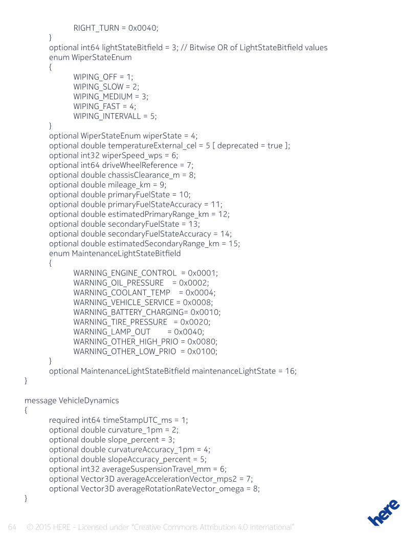
64 © 2015 HERE - Licensed under “Creative Commons Attribution 4.0 International”
RIGHT_TURN = 0x0040; } optional int64 lightStateBitfield = 3; // Bitwise OR of LightStateBitfield values enum WiperStateEnum { WIPING_OFF = 1; WIPING_SLOW = 2; WIPING_MEDIUM = 3; WIPING_FAST = 4; WIPING_INTERVALL = 5; } optional WiperStateEnum wiperState = 4; optional double temperatureExternal_cel = 5 [ deprecated = true ]; optional int32 wiperSpeed_wps = 6; optional int64 driveWheelReference = 7; optional double chassisClearance_m = 8; optional double mileage_km = 9; optional double primaryFuelState = 10; optional double primaryFuelStateAccuracy = 11; optional double estimatedPrimaryRange_km = 12; optional double secondaryFuelState = 13; optional double secondaryFuelStateAccuracy = 14; optional double estimatedSecondaryRange_km = 15; enum MaintenanceLightStateBitfield { WARNING_ENGINE_CONTROL = 0x0001; WARNING_OIL_PRESSURE = 0x0002; WARNING_COOLANT_TEMP = 0x0004; WARNING_VEHICLE_SERVICE = 0x0008; WARNING_BATTERY_CHARGING= 0x0010; WARNING_TIRE_PRESSURE = 0x0020; WARNING_LAMP_OUT = 0x0040; WARNING_OTHER_HIGH_PRIO = 0x0080; WARNING_OTHER_LOW_PRIO = 0x0100; } optional MaintenanceLightStateBitfield maintenanceLightState = 16;}
message VehicleDynamics{ required int64 timeStampUTC_ms = 1; optional double curvature_1pm = 2; optional double slope_percent = 3; optional double curvatureAccuracy_1pm = 4; optional double slopeAccuracy_percent = 5; optional int32 averageSuspensionTravel_mm = 6; optional Vector3D averageAccelerationVector_mps2 = 7; optional Vector3D averageRotationRateVector_omega = 8;}
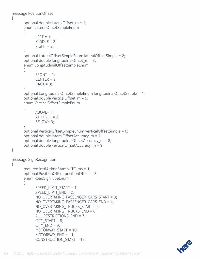
65 © 2015 HERE - Licensed under “Creative Commons Attribution 4.0 International”
message PositionOffset{ optional double lateralOffset_m = 1; enum LateralOffsetSimpleEnum { LEFT = 1; MIDDLE = 2; RIGHT = 3; } optional LateralOffsetSimpleEnum lateralOffsetSimple = 2; optional double longitudinalOffset_m = 3; enum LongitudinalOffsetSimpleEnum { FRONT = 1; CENTER = 2; BACK = 3; } optional LongitudinalOffsetSimpleEnum longitudinalOffsetSimple = 4; optional double verticalOffset_m = 5; enum VerticalOffsetSimpleEnum { ABOVE= 1; AT_LEVEL = 2; BELOW= 3; } optional VerticalOffsetSimpleEnum verticalOffsetSimple = 6; optional double lateralOffsetAccuracy_m = 7; optional double longitudinalOffsetAccuracy_m = 8; optional double verticalOffsetAccuracy_m = 9;}
message SignRecognition{ required int64 timeStampUTC_ms = 1; optional PositionOffset positionOffset = 2; enum RoadSignTypeEnum { SPEED_LIMIT_START = 1; SPEED_LIMIT_END = 2; NO_OVERTAKING_PASSENGER_CARS_START = 3; NO_OVERTAKING_PASSENGER_CARS_END = 4; NO_OVERTAKING_TRUCKS_START = 5; NO_OVERTAKING_TRUCKS_END = 6; ALL_RESTRICTIONS_END = 7; CITY_START = 8; CITY_END = 9; MOTORWAY_START = 10; MOTORWAY_END = 11; CONSTRUCTION_START = 12;
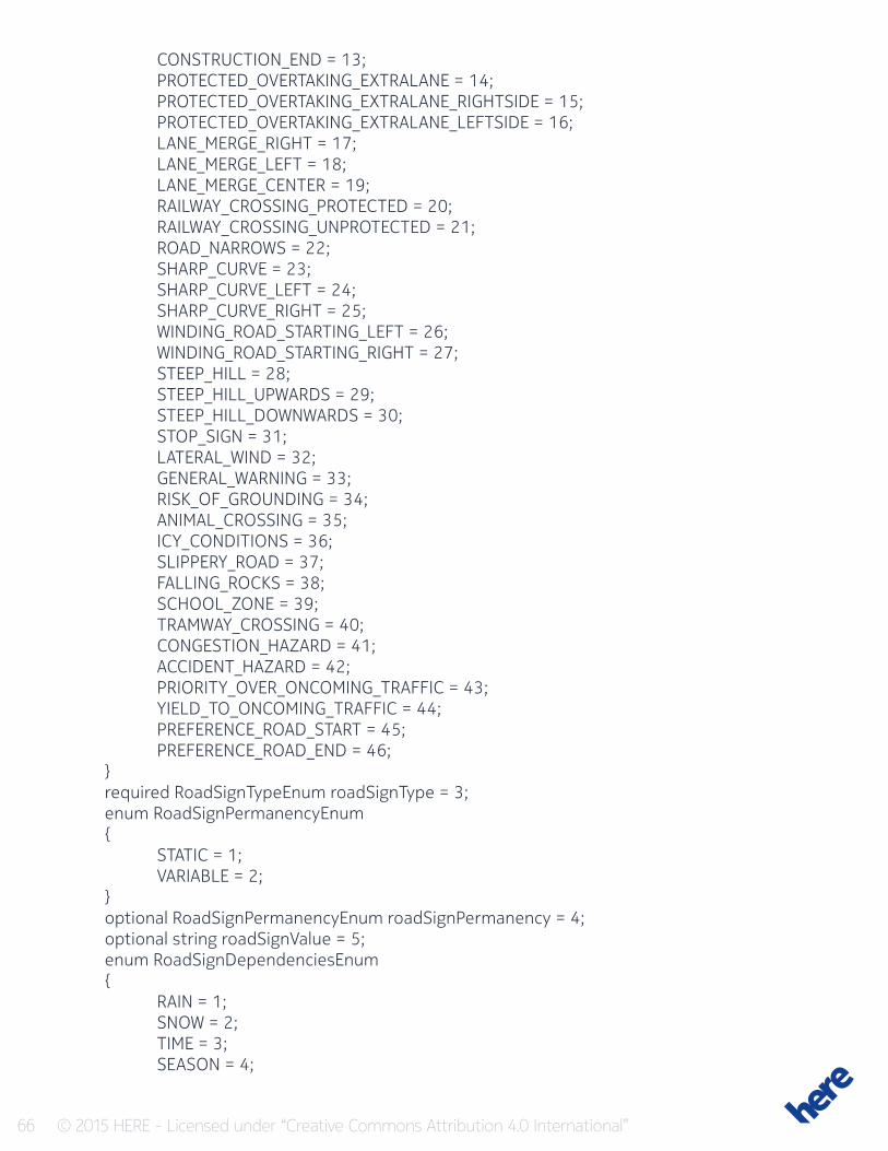
66 © 2015 HERE - Licensed under “Creative Commons Attribution 4.0 International”
CONSTRUCTION_END = 13; PROTECTED_OVERTAKING_EXTRALANE = 14; PROTECTED_OVERTAKING_EXTRALANE_RIGHTSIDE = 15; PROTECTED_OVERTAKING_EXTRALANE_LEFTSIDE = 16; LANE_MERGE_RIGHT = 17; LANE_MERGE_LEFT = 18; LANE_MERGE_CENTER = 19; RAILWAY_CROSSING_PROTECTED = 20; RAILWAY_CROSSING_UNPROTECTED = 21; ROAD_NARROWS = 22; SHARP_CURVE = 23; SHARP_CURVE_LEFT = 24; SHARP_CURVE_RIGHT = 25; WINDING_ROAD_STARTING_LEFT = 26; WINDING_ROAD_STARTING_RIGHT = 27; STEEP_HILL = 28; STEEP_HILL_UPWARDS = 29; STEEP_HILL_DOWNWARDS = 30; STOP_SIGN = 31; LATERAL_WIND = 32; GENERAL_WARNING = 33; RISK_OF_GROUNDING = 34; ANIMAL_CROSSING = 35; ICY_CONDITIONS = 36; SLIPPERY_ROAD = 37; FALLING_ROCKS = 38; SCHOOL_ZONE = 39; TRAMWAY_CROSSING = 40; CONGESTION_HAZARD = 41; ACCIDENT_HAZARD = 42; PRIORITY_OVER_ONCOMING_TRAFFIC = 43; YIELD_TO_ONCOMING_TRAFFIC = 44; PREFERENCE_ROAD_START = 45; PREFERENCE_ROAD_END = 46; } required RoadSignTypeEnum roadSignType = 3; enum RoadSignPermanencyEnum { STATIC = 1; VARIABLE = 2; } optional RoadSignPermanencyEnum roadSignPermanency = 4; optional string roadSignValue = 5; enum RoadSignDependenciesEnum { RAIN = 1; SNOW = 2; TIME = 3; SEASON = 4;
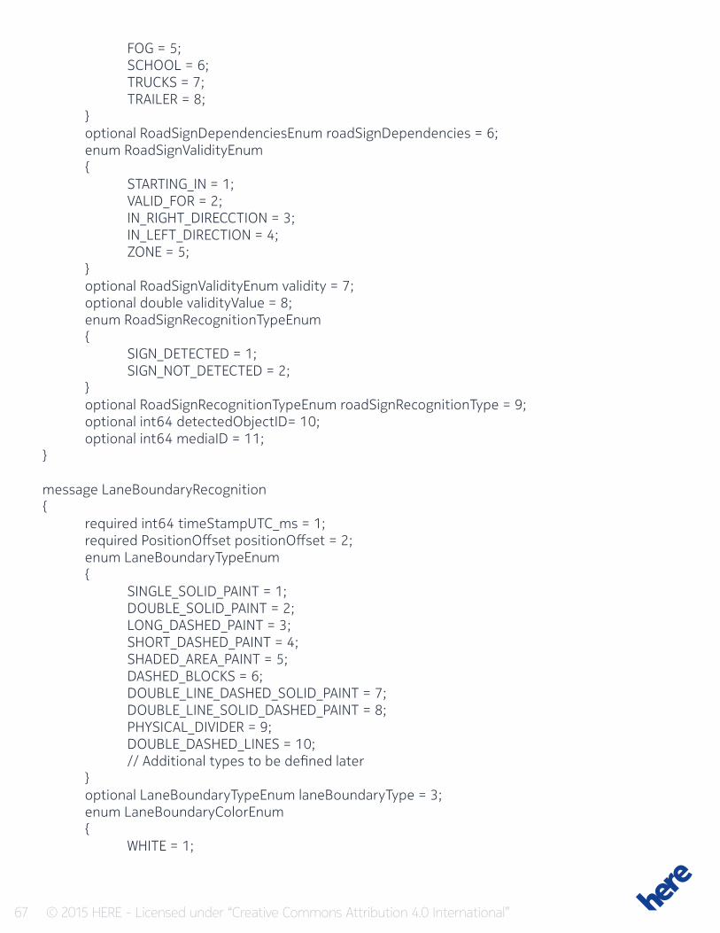
67 © 2015 HERE - Licensed under “Creative Commons Attribution 4.0 International”
FOG = 5; SCHOOL = 6; TRUCKS = 7; TRAILER = 8; } optional RoadSignDependenciesEnum roadSignDependencies = 6; enum RoadSignValidityEnum { STARTING_IN = 1; VALID_FOR = 2; IN_RIGHT_DIRECCTION = 3; IN_LEFT_DIRECTION = 4; ZONE = 5; } optional RoadSignValidityEnum validity = 7; optional double validityValue = 8; enum RoadSignRecognitionTypeEnum { SIGN_DETECTED = 1; SIGN_NOT_DETECTED = 2; } optional RoadSignRecognitionTypeEnum roadSignRecognitionType = 9; optional int64 detectedObjectID= 10; optional int64 mediaID = 11;}
message LaneBoundaryRecognition{ required int64 timeStampUTC_ms = 1; required PositionOffset positionOffset = 2; enum LaneBoundaryTypeEnum { SINGLE_SOLID_PAINT = 1; DOUBLE_SOLID_PAINT = 2; LONG_DASHED_PAINT = 3; SHORT_DASHED_PAINT = 4; SHADED_AREA_PAINT = 5; DASHED_BLOCKS = 6; DOUBLE_LINE_DASHED_SOLID_PAINT = 7; DOUBLE_LINE_SOLID_DASHED_PAINT = 8; PHYSICAL_DIVIDER = 9; DOUBLE_DASHED_LINES = 10; // Additional types to be defined later } optional LaneBoundaryTypeEnum laneBoundaryType = 3; enum LaneBoundaryColorEnum { WHITE = 1;
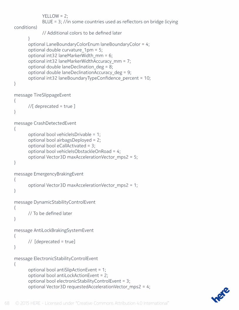
68 © 2015 HERE - Licensed under “Creative Commons Attribution 4.0 International”
YELLOW = 2; BLUE = 3; //in some countries used as reflectors on bridge (icying conditions) // Additional colors to be defined later } optional LaneBoundaryColorEnum laneBoundaryColor = 4; optional double curvature_1pm = 5; optional int32 laneMarkerWidth_mm = 6; optional int32 laneMarkerWidthAccuracy_mm = 7; optional double laneDeclination_deg = 8; optional double laneDeclinationAccuracy_deg = 9; optional int32 laneBoundaryTypeConfidence_percent = 10;}
message TireSlippageEvent{ //[ deprecated = true ]}
message CrashDetectedEvent{ optional bool vehicleIsDrivable = 1; optional bool airbagsDeployed = 2; optional bool eCallActivated = 3; optional bool vehicleIsObstackleOnRoad = 4; optional Vector3D maxAccelerationVector_mps2 = 5;}
message EmergencyBrakingEvent{ optional Vector3D maxAccelerationVector_mps2 = 1;}
message DynamicStabilityControlEvent { // To be defined later}
message AntiLockBrakingSystemEvent{ // [deprecated = true]}
message ElectronicStabilityControlEvent{ optional bool antiSlipActionEvent = 1; optional bool antiLockActionEvent = 2; optional bool electronicStabilityControlEvent = 3; optional Vector3D requestedAccelerationVector_mps2 = 4;
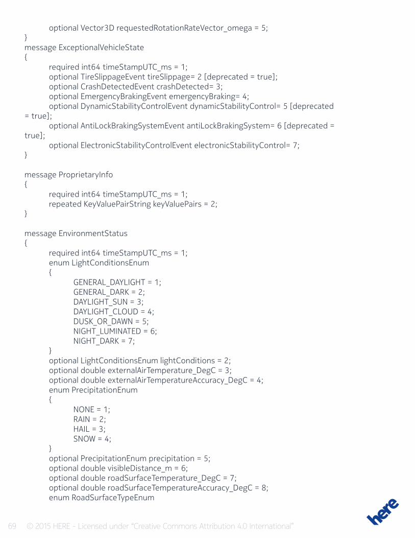
69 © 2015 HERE - Licensed under “Creative Commons Attribution 4.0 International”
optional Vector3D requestedRotationRateVector_omega = 5;}message ExceptionalVehicleState{ required int64 timeStampUTC_ms = 1; optional TireSlippageEvent tireSlippage= 2 [deprecated = true]; optional CrashDetectedEvent crashDetected= 3; optional EmergencyBrakingEvent emergencyBraking= 4; optional DynamicStabilityControlEvent dynamicStabilityControl= 5 [deprecated = true]; optional AntiLockBrakingSystemEvent antiLockBrakingSystem= 6 [deprecated = true]; optional ElectronicStabilityControlEvent electronicStabilityControl= 7;}
message ProprietaryInfo{ required int64 timeStampUTC_ms = 1; repeated KeyValuePairString keyValuePairs = 2;}
message EnvironmentStatus{ required int64 timeStampUTC_ms = 1; enum LightConditionsEnum { GENERAL_DAYLIGHT = 1; GENERAL_DARK = 2; DAYLIGHT_SUN = 3; DAYLIGHT_CLOUD = 4; DUSK_OR_DAWN = 5; NIGHT_LUMINATED = 6; NIGHT_DARK = 7; } optional LightConditionsEnum lightConditions = 2; optional double externalAirTemperature_DegC = 3; optional double externalAirTemperatureAccuracy_DegC = 4; enum PrecipitationEnum { NONE = 1; RAIN = 2; HAIL = 3; SNOW = 4; } optional PrecipitationEnum precipitation = 5; optional double visibleDistance_m = 6; optional double roadSurfaceTemperature_DegC = 7; optional double roadSurfaceTemperatureAccuracy_DegC = 8; enum RoadSurfaceTypeEnum
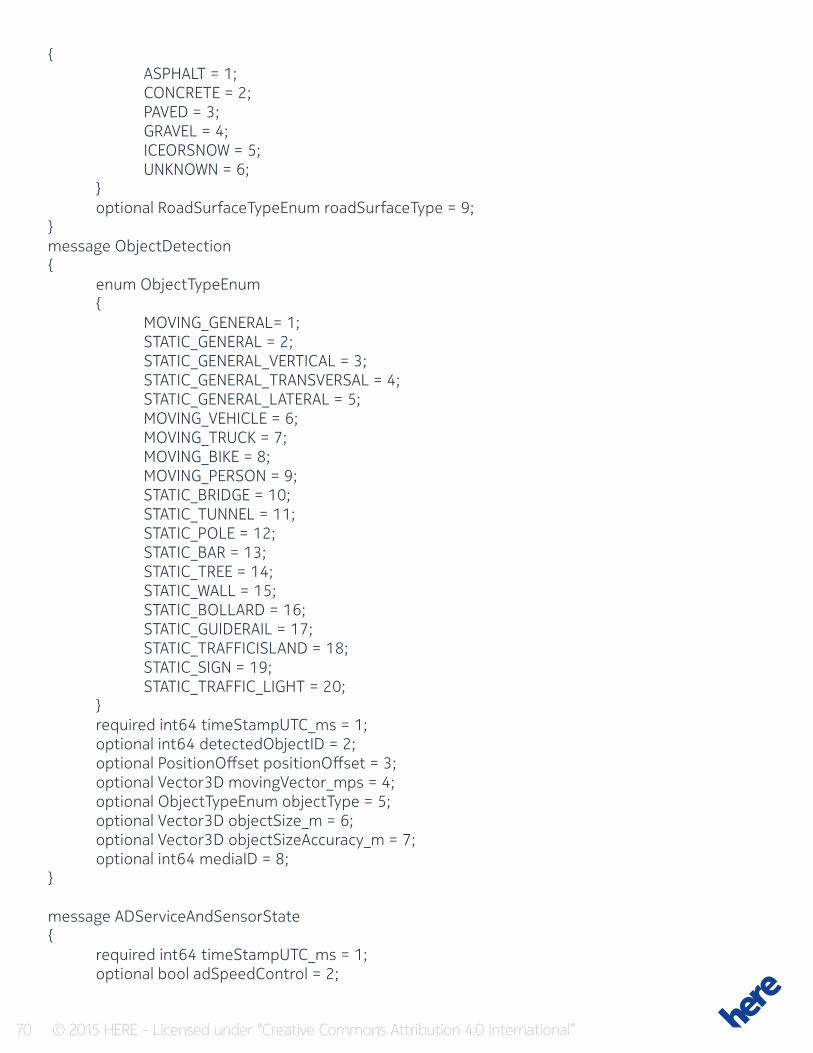
70 © 2015 HERE - Licensed under “Creative Commons Attribution 4.0 International”
{ ASPHALT = 1; CONCRETE = 2; PAVED = 3; GRAVEL = 4; ICEORSNOW = 5; UNKNOWN = 6; } optional RoadSurfaceTypeEnum roadSurfaceType = 9;}message ObjectDetection{ enum ObjectTypeEnum { MOVING_GENERAL= 1; STATIC_GENERAL = 2; STATIC_GENERAL_VERTICAL = 3; STATIC_GENERAL_TRANSVERSAL = 4; STATIC_GENERAL_LATERAL = 5; MOVING_VEHICLE = 6; MOVING_TRUCK = 7; MOVING_BIKE = 8; MOVING_PERSON = 9; STATIC_BRIDGE = 10; STATIC_TUNNEL = 11; STATIC_POLE = 12; STATIC_BAR = 13; STATIC_TREE = 14; STATIC_WALL = 15; STATIC_BOLLARD = 16; STATIC_GUIDERAIL = 17; STATIC_TRAFFICISLAND = 18; STATIC_SIGN = 19; STATIC_TRAFFIC_LIGHT = 20; } required int64 timeStampUTC_ms = 1; optional int64 detectedObjectID = 2; optional PositionOffset positionOffset = 3; optional Vector3D movingVector_mps = 4; optional ObjectTypeEnum objectType = 5; optional Vector3D objectSize_m = 6; optional Vector3D objectSizeAccuracy_m = 7; optional int64 mediaID = 8;}
message ADServiceAndSensorState{ required int64 timeStampUTC_ms = 1; optional bool adSpeedControl = 2;
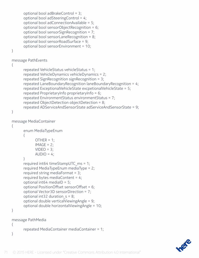
71 © 2015 HERE - Licensed under “Creative Commons Attribution 4.0 International”
optional bool adBrakeControl = 3; optional bool adSteeringControl = 4; optional bool adConnectionAvailable = 5; optional bool sensorObjectRecognition = 6; optional bool sensorSignRecognition = 7; optional bool sensorLaneRecognition = 8; optional bool sensorRoadSurface = 9; optional bool sensorEnvironment = 10;}
message PathEvents{ repeated VehicleStatus vehicleStatus = 1; repeated VehicleDynamics vehicleDynamics = 2; repeated SignRecognition signRecognition = 3; repeated LaneBoundaryRecognition laneBoundaryRecognition = 4; repeated ExceptionalVehicleState excpetionalVehicleState = 5; repeated ProprietaryInfo proprietaryInfo = 6; repeated EnvironmentStatus environmentStatus = 7; repeated ObjectDetection objectDetection = 8; repeated ADServiceAndSensorState adServiceAndSensorState = 9;}
message MediaContainer{ enum MediaTypeEnum { OTHER = 1; IMAGE = 2; VIDEO = 3; AUDIO = 4; } required int64 timeStampUTC_ms = 1; required MediaTypeEnum mediaType = 2; required string mediaFormat = 3; required bytes mediaContent = 4; optional int64 mediaID = 5; optional PositionOffset sensorOffset = 6; optional Vector3D sensorDirection = 7; optional int32 duration_s = 8; optional double verticalViewingAngle = 9; optional double horizontalViewingAngle = 10;}
message PathMedia{ repeated MediaContainer mediaContainer = 1;}

72 © 2015 HERE - Licensed under “Creative Commons Attribution 4.0 International”
message Message{ required Envelope envelope = 1; required Path path = 2; optional PathEvents pathEvents = 3; optional PathMedia pathMedia = 4;}