Embed Size (px)
Citation preview
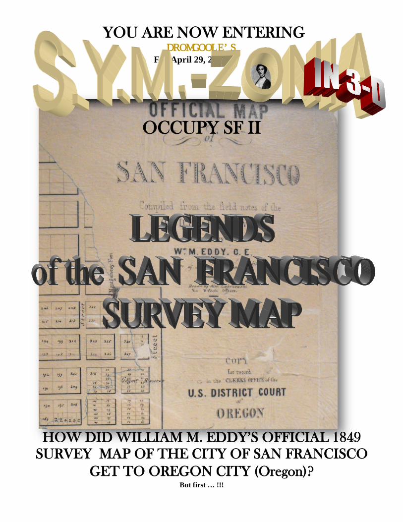
YOU ARE NOW ENTERING DROMGOOLE’S
For April 29, 2012
OCCUPY SF II
HOW DID WILLIAM M. EDDY’S OFFICIAL 1849 SURVEY MAP OF THE CITY OF SAN FRANCISCO
GET TO OREGON CITY (Oregon)? But first … !!!

IN THE NEWS …. As usual, Players!!! we cannot keep pace with developments !!!! We’ll bet -- certainly neither can you, Players!! One thing is, we just realized: that the first anniversary of Edmund Elmendorf’s IV’s death is coming upon us rapidly … as you know doubt no. How the year of mourning has fled!! We’re reviewing some of his “greatest hits” to see if we can glean any ideas or inspirations for what to run as this week approaches … See image at right > Meanwhile we were gathering and working diligently – but so far unsuccessfully -- to reassemble the scorched and charred fragments of the Story of Josephine Rollins and the little Indian Boy, from our burnt-out room at Motel 6, [see, the last issue of S.Y.M.-Zonia – Ed. ]. But the judge hearing our emergency petition for an adjustment in the conditions of our bail was less than understanding, and has ordered us to more or less the same terms, only this time, to a Self-Storage Unit at a fine facility on the Bay, in fact, in the Golden Gate, and with a view of Alcatraz …. !! SELF-STORAGE? It has been said, in Shakespeare, Hamlet, I think, that “Verily, the body is kind of a Self-Storage unit,” and also that the eyes are the window of the soul. And so it is little short of remarkable, that we should be shut in here, in a Self-Storage unit, that has no windows! How totally ironic !! No windows -- Instead, only a rolling garage-door like a roll-top desk, a specially installed porta-potty, and a Coleman stove from Good-Will. The judge who ruled on our petition, stated that I could do here what I wanted, while the cause of the Motel 6 fire is investigated – and that the structure was not flammable, and also that I could “consider it an opportunity” to admire the Alcatraz architecture. He was NOT interested in my point, that Alcatraz is really Yerba Buena, and Yerba Beuna is Alcatraz. or Albatross, to all of us S.Y.M.-Zonians. See, OCCUPY SF! (January 15, 2012) – - My (court-appointed ) attorney declined to present a copy to hizzoner. Meanwhile, the ankle bracelet is still on: I wouldn’t call it a win – yet. Applied for a name change while downtown. Here’s my advance ticket to the new Poe movie, The RAVEN – I won’t be using it. Will watch it on DVD … Let’s see … You want EVEN MORE SHIPWRECKS ??! We continue to get an almost overwhelming response to our “Shipwreck” series – “launched,” so to speak, with the A.C.R.O.P.Y.M. Puzzler, How Can You Explain the Shipwrack of David Fasold’s Noah’s Ark? (March 18, 2012) -- which was also a send-off for the beloved, old P.Y.M. ™ Puzzler -- and then continued with the recent What’s Sunken Under Sand Island, blah blah, …. ? (March 25, 2012). But how many of these can there be? And, Players! Shouldn’t you solve one Shipwreck in S.Y.M.-Zonia … before moving on to another? After all, this vessel under Sand Island -- its just an old wooden warship ….. ooops …. under some sedimentary deposits right there on the waterfront – it’s not like raising the TITANIC!! Heck …. Man up. I have been trying to contact Ass Dr. Beckon to confer on whether we should provide a hint or two on this. Reports are, she was rescued from her kayak by a Coast Guard helicopter, which airlifted her to safety off Cape Foulweather –the ling cod is also safe. Looking forward … So its too early for another REAL “shipwreck” S.Y.M.-Zonia, and instead, in this one, we’ll just give you a general IDEA about where to look for a few of them, without focusing in on any one shipwreck in particular. Thus, this S.Y.M–Zonia returns to San Francisco to coincide with the ongoing OCCUPY S.F. demonstrations, this week, May 1 – MAYDAY! -- being staged at the Golden Gate bridge, out my front door!!. OKAY. So, fasten your seat belts… Players ….. YOU ARE NOW ENTERING POPULATION: 1
WELCOME ARDENT PLAYERS !!
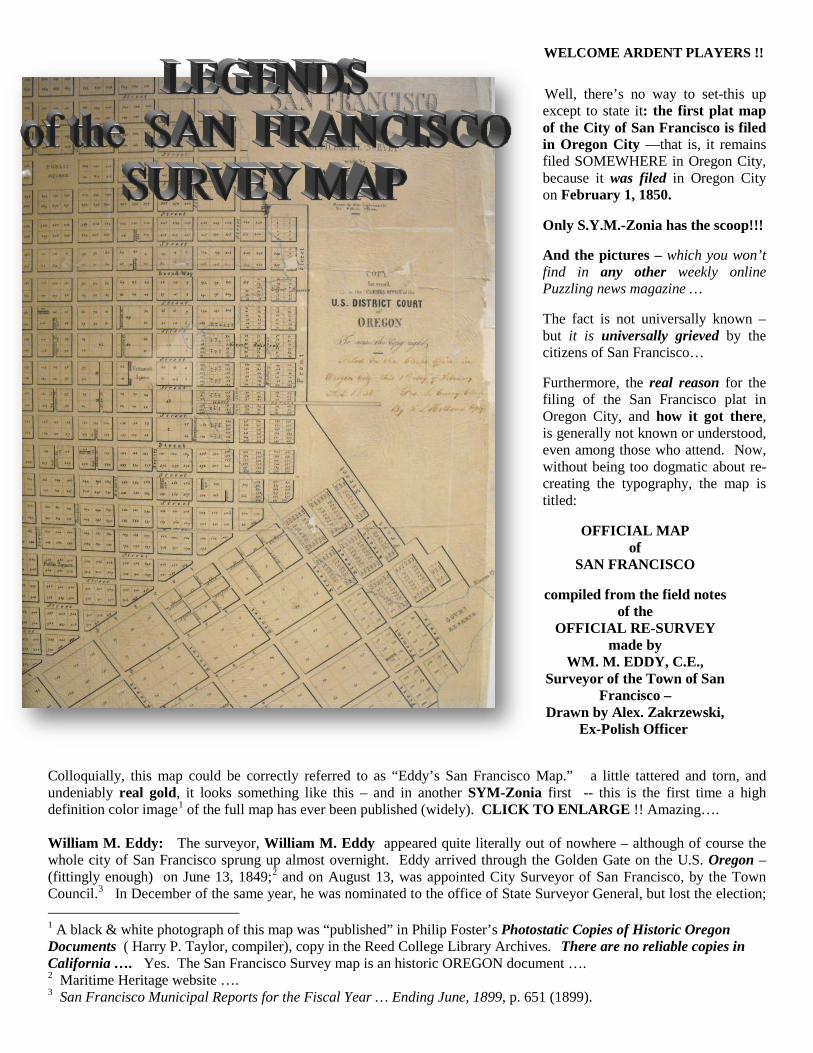
Well, there’s no way to set-this up except to state it: the first plat map of the City of San Francisco is filed in Oregon City —that is, it remains filed SOMEWHERE in Oregon City, because it was filed in Oregon City on February 1, 1850.
Only S.Y.M.-Zonia has the scoop!!!
And the pictures – which you won’t find in any other weekly online Puzzling news magazine …
The fact is not universally known – but it is universally grieved by the citizens of San Francisco…
Furthermore, the real reason for the filing of the San Francisco plat in Oregon City, and how it got there, is generally not known or understood, even among those who attend. Now, without being too dogmatic about re-creating the typography, the map is titled:
OFFICIAL MAP of
SAN FRANCISCO
compiled from the field notes of the
OFFICIAL RE-SURVEY made by
WM. M. EDDY, C.E., Surveyor of the Town of San
Francisco – Drawn by Alex. Zakrzewski,
Ex-Polish Officer
Colloquially, this map could be correctly referred to as “Eddy’s San Francisco Map.” a little tattered and torn, and undeniably real gold, it looks something like this – and in another SYM-Zonia first -- this is the first time a high definition color image1
of the full map has ever been published (widely). CLICK TO ENLARGE !! Amazing….
William M. Eddy: The surveyor, William M. Eddy appeared quite literally out of nowhere – although of course the whole city of San Francisco sprung up almost overnight. Eddy arrived through the Golden Gate on the U.S. Oregon – (fittingly enough) on June 13, 1849;2 and on August 13, was appointed City Surveyor of San Francisco, by the Town Council.3
1 A black & white photograph of this map was “published” in Philip Foster’s Photostatic Copies of Historic Oregon Documents ( Harry P. Taylor, compiler), copy in the Reed College Library Archives. There are no reliable copies in California …. Yes. The San Francisco Survey map is an historic OREGON document ….
In December of the same year, he was nominated to the office of State Surveyor General, but lost the election;
2 Maritime Heritage website …. 3 San Francisco Municipal Reports for the Fiscal Year … Ending June, 1899, p. 651 (1899).
yet only a few days later, he was elected City Surveyor in the first charter election of San Francisco. Thereafter, in the summer of 1851, Eddy was the Democratic nominee for the state-wide office of Surveyor General, and was elected to that position in November, 1851.4 During this same period, it appears he was also able to fit in some private surveying jobs.5 On April 10, 1854, The New York Times reported his death, had occurred “within the fortnight.”6
The San Francisco map indicates, it was made from the survey work of “Wm. Eddy, C.E., Surveyor of the Town of San Francisco,” and so derives from the period following his appointment by the San Francisco town Council, or ayuntamiento: Theodore H. Hittel chronicled the development, and proves our map is authentic:
On October 3 [1849] the ayuntamiento ordered William M. Eddy, whom it had appointed city surveyor, to extend the old O'Farrell7
Once completed, and drawn up by his associate Alexander Zakrzewski,
survey north, west and south, so as to include all the land between the water front, including Telegraph, Russian and Rincon Hills, and Larkin and Eighth streets on the west and south. All the lots of the old survey had been sold and more were needed for the rapid increase of population and advance of the city….
8 “Ex-Polish officer,” Eddy’s San Francisco Map was then indeed published: but we know it –generally – not through copies printed by the San Francisco Town Council, but rather because it was incorporated with a U.S. government document, Report of the Secretary of the Interior, communicating a copy of the report of William Carey Jones, special agent to examine the subject of land titles in California, April 23, 1850.9
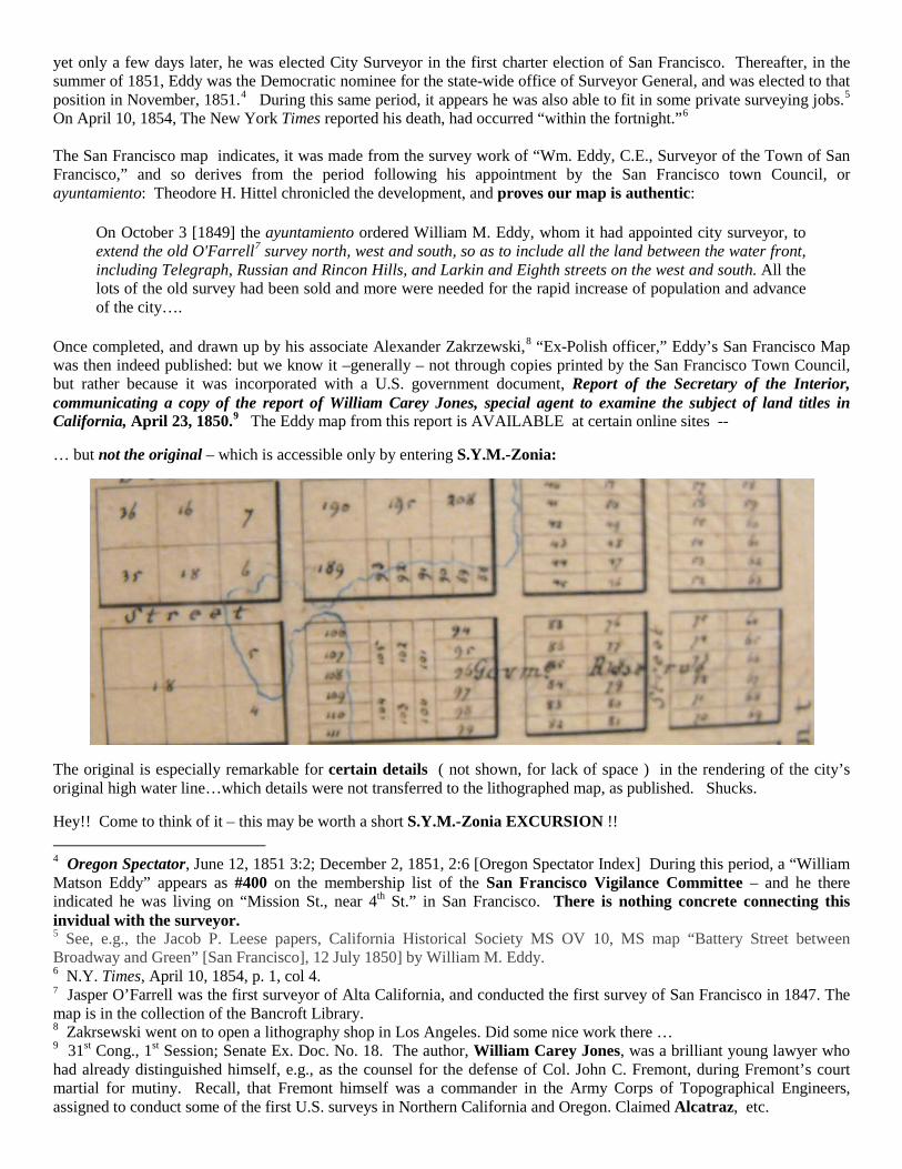
… but not the original – which is accessible only by entering S.Y.M.-Zonia:
The Eddy map from this report is AVAILABLE at certain online sites --
The original is especially remarkable for certain details ( not shown, for lack of space ) in the rendering of the city’s original high water line…which details were not transferred to the lithographed map, as published. Shucks.
Hey!! Come to think of it – this may be worth a short S.Y.M.-Zonia EXCURSION !! 4 Oregon Spectator, June 12, 1851 3:2; December 2, 1851, 2:6 [Oregon Spectator Index] During this period, a “William Matson Eddy” appears as #400 on the membership list of the San Francisco Vigilance Committee – and he there indicated he was living on “Mission St., near 4th St.” in San Francisco. There is nothing concrete connecting this invidual with the surveyor. 5 See, e.g., the Jacob P. Leese papers, California Historical Society MS OV 10, MS map “Battery Street between Broadway and Green” [San Francisco], 12 July 1850] by William M. Eddy. 6 N.Y. Times, April 10, 1854, p. 1, col 4. 7 Jasper O’Farrell was the first surveyor of Alta California, and conducted the first survey of San Francisco in 1847. The map is in the collection of the Bancroft Library. 8 Zakrsewski went on to open a lithography shop in Los Angeles. Did some nice work there … 9 31st Cong., 1st Session; Senate Ex. Doc. No. 18. The author, William Carey Jones, was a brilliant young lawyer who had already distinguished himself, e.g., as the counsel for the defense of Col. John C. Fremont, during Fremont’s court martial for mutiny. Recall, that Fremont himself was a commander in the Army Corps of Topographical Engineers, assigned to conduct some of the first U.S. surveys in Northern California and Oregon. Claimed Alcatraz, etc.

EXCURSION
William M. Eddy, Milo Hoadley and the Murder of James King of
William PLAYERS!!! Just sit back and relax …., while we take you on a short S.Y.M.-Zonia EXCURSION of San Francisco … just a brief excursion into a few of the hidden secrets of the ORIGINAL and AUTHENTIC MS map of the City of San Francisco, by San Francisco City Surveyor, William M. Eddy – and NO!! we’re not talking about the hidden text behind the COMPASS PASTE-DOWN in the upper left quadrant of the map … which of course does not appear on any of the lithographed versions of Eddy’s masterpiece…
WHY WOULD WE??
That’s been done before!!! by the illustrious Elmendorf, in the memorable P.Y.M. ™ Puzzler, Under The Compass Paste-Down: Can You Decrypt Eddy’s Secret Ciphers? (February 23, 2008). No maps were damaged in the creation of that interesting Puzzler; and here too, as Elmendorf did there, our object is only to illuminate -- as by the U.V. light of the mind -- what otherwise might go unnoticed ….
But S.Y.M.-Zonia, of course, is not just a mere extension of the old P.Y.M. ™ Puzzler, but is
always looking to break NEW GROUND, even …
BELOW the WATERLINE …
Like … a shipwreck? And indeed, the issue involved in this S.Y.M.-Zonia EXCURISON , is groundbreaking, because it affords you PLAYERS a look at San Francisco BELOW THE WATERLINE, taking you into regions of San Francisco, that are both submarine and subterranean – like we said: as we did fairly recently, for instance in What’s Sunken Under Sand Island, etc. etc. ? (April 15, 2012). (That huge vessel, of course, is both under land and underwater!!! )
Only …. here, as we said, the questions arises in the careful demarcation by Eddy, of the original waterline of the city, back when it was merely homely old Yerba Buena: details of that waterline were only reproduced with …. some relative accuracy in the lithographed versions published to accompany William Carey Jones’ Report on Land Titles, etc. The mad-map collector, Rumsey ™ -- who deserves an ankle-bracelet at least -- has these printed version !! the lithographs -- but not the real McCoy – which is visible only on your S.Y.M.-Zonia Map Browser. So let’s TURN IT ON!
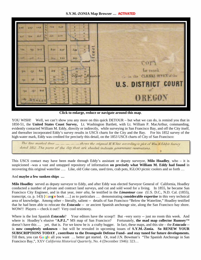
S.Y.M.-ZONIA Map Browser … ACTIVATED
Click to enlarge, reduce or navigate around this map.
YOU WISH! Well, we can’t show you any more on this quick DETOUR – but what we can do, is remind you that in 1850-51, the United States Coast Survey, Lt. Washington Bartlett, with Lt. William P. MacArthur, commanding, evidently contacted William M. Eddy, directly or indirectly, while surveying in San Francisco Bay, and off the City itself, and thereafter incorporated Eddy’s survey results in USCS charts for the City and the Bay. For his 1852 survey of the high-water mark, Eddy was credited for precisely this detail, on the 1853 USCS charts of City of San Francisco:
This USCS contact may have been made through Eddy’s assistant or deputy surveyor, Milo Hoadley, who – it is suspicioned –was a vast and untapped repository of information on precisely what William M. Eddy had found in recovering this original waterline …. Like, old Coke cans, used tires, crab pots, IGLOO picnic coolers and so forth …
And maybe a few sunken ships …
Milo Hoadley served as deputy surveyor to Eddy, and after Eddy was elected Surveyor General of California, Hoadley conducted a number of private and contract land surveys, and cut and sold wood for a living. In 1855, he became San Francisco City Engineer, and in that year, inter alia, he testified in the Limantour case (U.S. D.C., N.D. Cal. (1855), transcript, ca. p. 143) [Gargle book ….] as to particulars … demonstrating considerable expertise in this very technical area of knowledge. Among other – literally, salient -- details of San Francisco “Below the Waterline,” Hoadley testified that he had been able to relocate the Estacada -- or ancient Spanish anchorage site, along the San Francisco bay shore. WOW!! Players -- check it out!! Very cool testimony.
Where is the lost Spanish Estacada? Your editors have the scoop!! But –very sorry -- just no room this week. And where is Hoadley’s elusive “A.P.L.” MS map of San Francisco? Fortunately, the mad map collector Rumsey™ doesn’t have this … yet, that is. For we know he is a crafty bugger. In fact, these maps, and this site – the Estacada -- is now completely unknown – but will be revealed in upcoming issues of S.Y.M.-Zonia. So RENEW YOUR SUBSCRIPTIONS TODAY , contribute to the Dromgoole Defense Fund– and stay tuned for future developments. Till then, you can Gargle all you want … better get started. Or, read J.N. Bowman’s “The Spanish Anchorage in San Francisco Bay,”, XXV California Historical Quarterly, No. 4 (December 1946): 323…
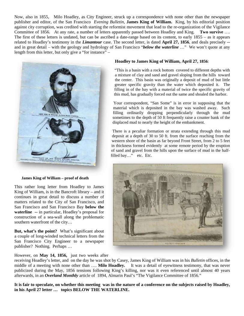
Now, also in 1855, Milo Hoadley, as City Engineer, struck up a correspondence with none other than the newspaper publisher and editor, of the San Francisco Evening Bulletin, James King of William. King, by his editorial position against city corruption, was credited with starting the reformist movement that lead to the re-organization of the Vigilance Committee of 1856. At any rate, a number of letters apparently passed between Hoadley and King. Two survive …. The first of these letters is undated, but can be ascribed a date-range based on its content, to early 1855 – as it appears related to Hoadley’s testimony in the Limantour case. The second letter, is dated April 27, 1856, and deals precisely -- and in great detail – with the geology and hydrology of San Francisco “below the waterline …” We won’t quote at any length from this letter, but only give a “for instance” –
Hoadley to James King of William, April 27, 1856:
“This is a basin with a rock bottom covered to different depths with a mixture of clay and sand and gravel sloping from the hills toward the center. This basin was originally a deposit of mud of but little greater specific gravity than the water which deposited it. The filling in of the bay with a material of twice the specific gravity of this mud, has gradually forced out the same and shoaled the harbor.
Your correspondent, “San Some” is in error in supposing that the material which is deposited in the bay was washed away. Such filling ordinarily dropping perpendicularly through the mud sometimes to the depth of 50 ft frequently raise a counter bank of the displaced mud to nearly the height of the embankment.
There is a peculiar formation or strata extending through this mud deposit at a depth of 30 to 50 ft. from the surface reaching from the western shore of the basin as far beyond Front Street, from 2 to 5 feet in thickness formed evidently at some remote period by the eruption of sand and gravel from the hills upon the surface of mud in the half-filled bay…” etc. Etc.
James King of William – proof of death
This rather long letter from Hoadley to James King of William, is in the Bancroft library – and it continues in great detail to discuss a number of matters related to the City of San Francisco, and San Francisco and San Francisco Bay below the waterline -- in particular, Hoadley’s proposal for construction of a sea-wall along the problematic southern waterfront of the city…
But, what’s the point? What’s significant about a couple of long-winded technical letters from the San Francisco City Engineer to a newspaper publisher? Nothing. Perhaps …
However, on May 14, 1856, just two weeks after receiving Hoadley’s letter, and on the day he was shot by Casey, James King of William was in his Bulletin offices, in the middle of a meeting with none other than …. Milo Hoadley. It was a detail of eyewitness testimony, that was never publicized during the May, 1856 tensions following King’s killing, nor was it even referenced until almost 40 years afterwards, in an Overland Monthly article of 1894, Almarin Paul’s “The Vigilance Committee of 1856.”
It is fair to speculate, on whether this meeting was in the nature of a conference on the subjects raised by Hoadley, in his April 27 letter … topics BELOW THE WATERLINE.
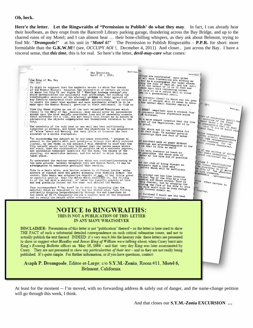
Oh, heck.
Here’e the letter. Let the Ringwraiths of “Permission to Publish’ do what they may. In fact, I can already hear their hoofbeats, as they erupt from the Bancroft Library parking garage, thundering across the Bay Bridge, and up to the charred ruins of my Motel; and I can almost hear … their bone-chilling whispers, as they ask about Belmont, trying to find Mr. “Dromgoole!” at his unit in “Motel 6!” The Permission to Publish Ringwraiths – P.P.R. for short: more formidable than the G.K.W.M!! (see, OCCUPY AOI !, Decmeber 4, 2011) And closer.. just across the Bay. I have a visceral sense, that this time, this is for real. So here’s the letter, devil-may-care what comes:
At least for the moment -- I’m moved, with no forwarding address & safely out of danger, and the name-change petition will go through this week, I think.
And that closes our S.Y.M.-Zonia EXCURSION …
As Surveyor-General of California, William M. Eddy was authorized by the 1853 California legislature to publish and distribute “the official map of the State.”10
Maybe. Meanwhile, by statute, Eddy’s errors were NOT made official; only the good parts:
But in a real oddball bit of legal acrobatics, that may prove “weird Eddy” was also a smooth operator, Eddy himself retained the copyright on “The Official Map of the State” -- although he was made responsible to provide copies to the State of California willy-nilly, “at cost.” Such reciprocal back-scratching agreements were maybe not uncommon and were hardly noteworthy in the days of the Vigilance Committee justice system. Certainly the Legislature didn’t bat an eyelash. But was this ‘quirk’ over his copyright evidence that Eddy partook of an artistic and jealous temperament over his creation?
Section 1: The Map compiled by William M. Eddy, Surveyor-General, under “an Act to provide for a Map of the State,” is hereby declared the official map of the State: Provided, that nothing in this section shall be construed to declare official, so much of the eastern boundary line as relates to the territory in the vicinity of Carson’s Valley, which portion is left open for future surveys.
Section 2. The State hereby relinquishes to the said William M. Eddy her interest in the copyright of said Map.
Section 3. The said Eddy, in consideration of the relinquishment in the foregoing section, shall have the said Map of the State of California properly engraved on copper plates, and shall furnish one copy thereof to each of the following persons and officers: To each member of the present legislature, to each State officer for the use of the State, and to the office of each County Clerk in the State, also to each new county hereafter formed.11
(Emphasis added.)
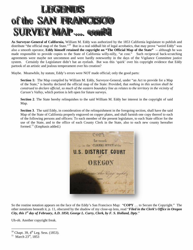
So the routine notation appears on the face of the Eddy’s San Francisco Map: “COPY … to Secure the Copyright.” The other notations beneath it, p. 11, obscured by the shadow of my close-up lens, read “Filed in the Clerk’s Office in Oregon City, this 1st day of February, A.D. 1850, George L. Curry, Clerk, by F. S. Holland, Dpty.”
Uh-oh. Another copyright freak.
10 Chapt. 39, 4th Leg. Sess. (1853). 11 March 23rd, 1853
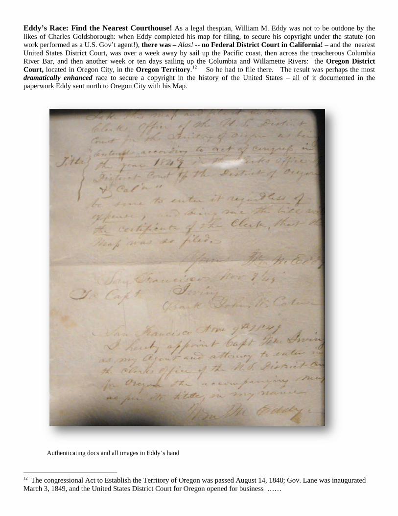
Eddy’s Race: Find the Nearest Courthouse! As a legal thespian, William M. Eddy was not to be outdone by the likes of Charles Goldsborough: when Eddy completed his map for filing, to secure his copyright under the statute (on work performed as a U.S. Gov’t agent!), there was – Alas! -- no Federal District Court in California! – and the nearest United States District Court, was over a week away by sail up the Pacific coast, then across the treacherous Columbia River Bar, and then another week or ten days sailing up the Columbia and Willamette Rivers: the Oregon District Court, located in Oregon City, in the Oregon Territory.12
So he had to file there. The result was perhaps the most dramatically enhanced race to secure a copyright in the history of the United States – all of it documented in the paperwork Eddy sent north to Oregon City with his Map.
Authenticating docs and all images in Eddy’s hand
12 The congressional Act to Establish the Territory of Oregon was passed August 14, 1848; Gov. Lane was inaugurated March 3, 1849, and the United States District Court for Oregon opened for business ……

Eddy’s cover letter included with the map, , indicates that Eddy delivered this “COPY for Record in the Clerk’s Office of the U.S. District Court of OREGON” to Captain Wm. Irving13
Take this map and file it in the Clerk’s Office of the U.S. District Court for the Territory of Oregon, as being Title: {“Entered according to Act of Congress in the year 1849 { in the Clerk’s office of the District Court of { Oregon and for Cal’a”
of the merchant bark John W. Cater, a coasting trade vessel. The full text of Eddy’s handwritten instructions of Capt. Irving looks and reads something like this:
Be sure to enter it regardless of expenses, and bring me the bill and the certificate of the Clerk, that the map was so filed.
Yours,
Wm. M. Eddy,
San Francisco, Nov 9/49
To Capt. Irving Bark John W. Cater
Followed by this letter of attorney:
San Francisco, Nov, 9, 1849
I hereby appoint Capt. William Irving as my agent and attorney to enter in the Clerk’s Office for the U.S. Court for Oregon the accompanying map as per the letter,
in my name,
William M. Eddy [#400 ]
But why? And HOW?
It would sure keep the map safe from local problems … like, for instance … fires.
13 This is the same William Irving after whom Portland’s Irvington neighborhood is named. Capt. Irving was prominent in the Columbia-Willamette merchant trade beginning in 1849, as master of vessels like the Success and the Express.