Embed Size (px)
Citation preview
Central Bureau of StatisticsMinistry of Planning and National Development
Department of Resource Surveys and Remote SensingMinistry of Environment and Natural Resources
CHAPTER 3 Water
Nature’s Benefits in Kenya:An Atlas of Ecosystems and Human Well-Being
Central Bureau of StatisticsMinistry of Planning and National Development
Department of Resource Surveys and Remote SensingMinistry of Environment and Natural Resources
NATURE’S BENEFITS IN KENYA: AN ATLAS OF ECOSYSTEMS AND HUMAN WELL-BEING
Chapter 3
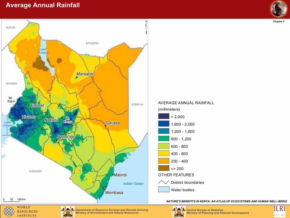
Average Annual Rainfall
AVERAGE ANNUAL RAINFALL
(millimeters)
> 2,000
1,600 - 2,000
1,200 - 1,600
800 - 1,200
600 - 800
400 - 600
200 - 400
<= 200
OTHER FEATURES
District boundaries
Water bodies
Central Bureau of StatisticsMinistry of Planning and National Development
Department of Resource Surveys and Remote SensingMinistry of Environment and Natural Resources
NATURE’S BENEFITS IN KENYA: AN ATLAS OF ECOSYSTEMS AND HUMAN WELL-BEING
Chapter 3
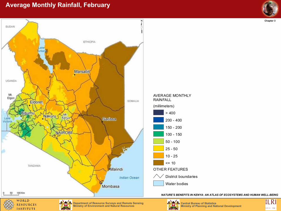
Average Monthly Rainfall, February
RAINFALL
(millimeters)
> 400
200 - 400
150 - 200
100 - 150
50 - 100
25 - 50
10 - 25
<= 10
OTHER FEATURES
District boundaries
Water bodies
AVERAGE MONTHLY
Central Bureau of StatisticsMinistry of Planning and National Development
Department of Resource Surveys and Remote SensingMinistry of Environment and Natural Resources
NATURE’S BENEFITS IN KENYA: AN ATLAS OF ECOSYSTEMS AND HUMAN WELL-BEING
Chapter 3
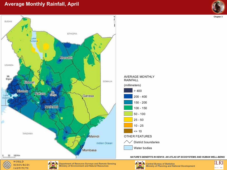
Average Monthly Rainfall, April
RAINFALL
(millimeters)
> 400
200 - 400
150 - 200
100 - 150
50 - 100
25 - 50
10 - 25
<= 10
OTHER FEATURES
District boundaries
Water bodies
AVERAGE MONTHLY
Central Bureau of StatisticsMinistry of Planning and National Development
Department of Resource Surveys and Remote SensingMinistry of Environment and Natural Resources
NATURE’S BENEFITS IN KENYA: AN ATLAS OF ECOSYSTEMS AND HUMAN WELL-BEING
Chapter 3
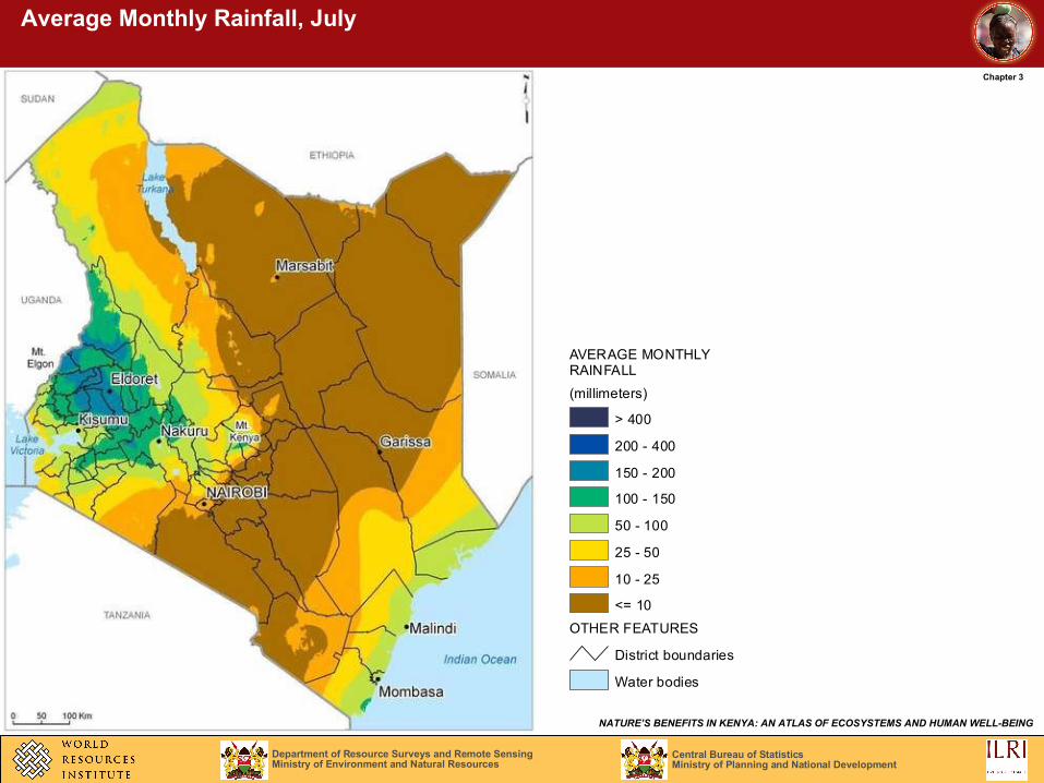
Average Monthly Rainfall, July
RAINFALL
(millimeters)
> 400
200 - 400
150 - 200
100 - 150
50 - 100
25 - 50
10 - 25
<= 10
OTHER FEATURES
District boundaries
Water bodies
AVERAGE MONTHLY
Central Bureau of StatisticsMinistry of Planning and National Development
Department of Resource Surveys and Remote SensingMinistry of Environment and Natural Resources
NATURE’S BENEFITS IN KENYA: AN ATLAS OF ECOSYSTEMS AND HUMAN WELL-BEING
Chapter 3
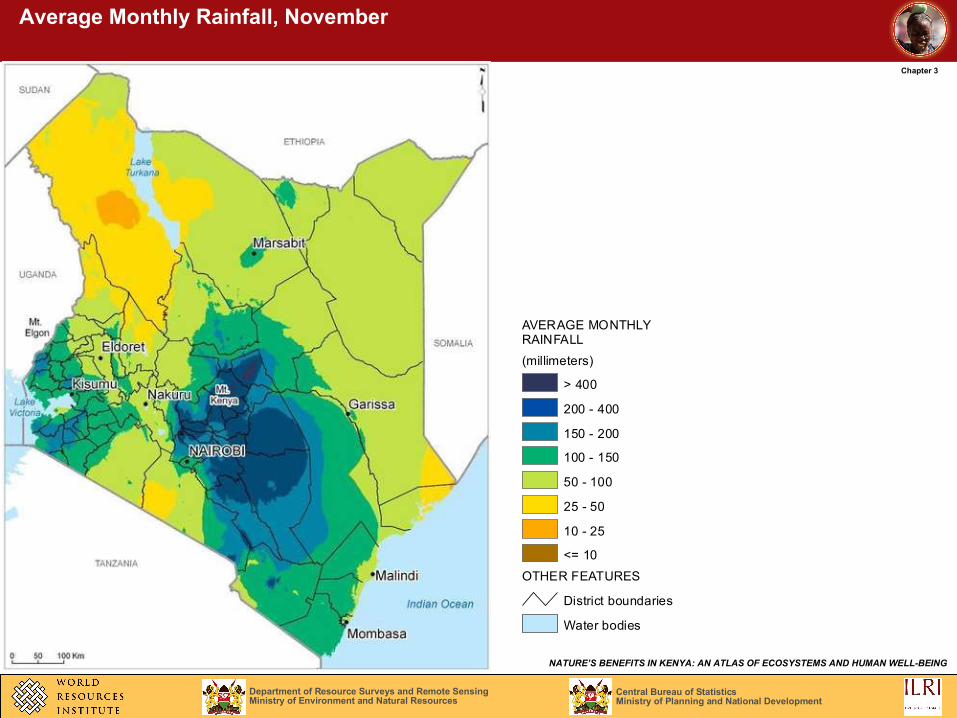
Average Monthly Rainfall, November
RAINFALL
(millimeters)
> 400
200 - 400
150 - 200
100 - 150
50 - 100
25 - 50
10 - 25
<= 10
OTHER FEATURES
District boundaries
Water bodies
AVERAGE MONTHLY
Central Bureau of StatisticsMinistry of Planning and National Development
Department of Resource Surveys and Remote SensingMinistry of Environment and Natural Resources
NATURE’S BENEFITS IN KENYA: AN ATLAS OF ECOSYSTEMS AND HUMAN WELL-BEING
Chapter 3
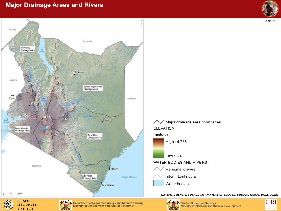
Major Drainage Areas and Rivers
Major drainage area boundaries
ELEVATION
(meters)
High : 4,786
Low : -24
WATER BODIES AND RIVERS
Permanent rivers
Intermittent rivers
Water bodies

Central Bureau of StatisticsMinistry of Planning and National Development
Department of Resource Surveys and Remote SensingMinistry of Environment and Natural Resources
NATURE’S BENEFITS IN KENYA: AN ATLAS OF ECOSYSTEMS AND HUMAN WELL-BEING
Chapter 3
Annual Projected Water Balance by Subdrainage Area, 2000 and 2010
WATER BALANCE
Deficit in both 2000 and 2010
Deficit in 2010
No deficit foreseen
DRAINAGE BOUNDARIES
Major drainage area boundaries
Subdrainage area boundaries
WATER BODIES AND RIVERS
Permanent rivers
Intermittent rivers
Water bodies
Central Bureau of StatisticsMinistry of Planning and National Development
Department of Resource Surveys and Remote SensingMinistry of Environment and Natural Resources
NATURE’S BENEFITS IN KENYA: AN ATLAS OF ECOSYSTEMS AND HUMAN WELL-BEING
Chapter 3
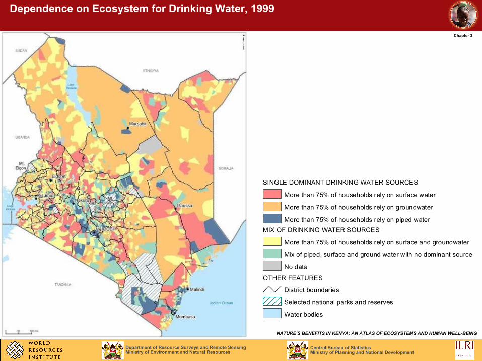
Dependence on Ecosystem for Drinking Water, 1999
SINGLE DOMINANT DRINKING WATER SOURCES
More than 75% of households rely on surface water
More than 75% of households rely on groundwater
More than 75% of households rely on piped water
MIX OF DRINKING WATER SOURCES
More than 75% of households rely on surface and groundwater
Mix of piped, surface and ground water with no dominant source
No data
OTHER FEATURES
District boundaries
Selected national parks and reserves
Water bodies
Central Bureau of StatisticsMinistry of Planning and National Development
Department of Resource Surveys and Remote SensingMinistry of Environment and Natural Resources
NATURE’S BENEFITS IN KENYA: AN ATLAS OF ECOSYSTEMS AND HUMAN WELL-BEING
Chapter 3
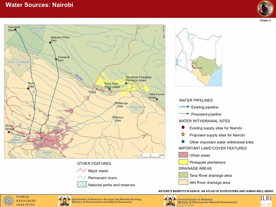
Water Sources: Nairobi
WATER PIPELINES
Existing pipeline
Proposed pipeline
WATER WITHDRAWAL SITES
Existing supply sites for Nairobi
Proposed supply sites for Nairobi
Other important water withdrawal sites
IMPORTANT LAND COVER FEATURES
Urban areas
Pineapple plantations
DRAINAGE AREAS
Tana River drainage area
Athi River drainage area
OTHER FEATURES
Major roads
Permanent rivers
National parks and reserves
Central Bureau of StatisticsMinistry of Planning and National Development
Department of Resource Surveys and Remote SensingMinistry of Environment and Natural Resources
NATURE’S BENEFITS IN KENYA: AN ATLAS OF ECOSYSTEMS AND HUMAN WELL-BEING
Chapter 3
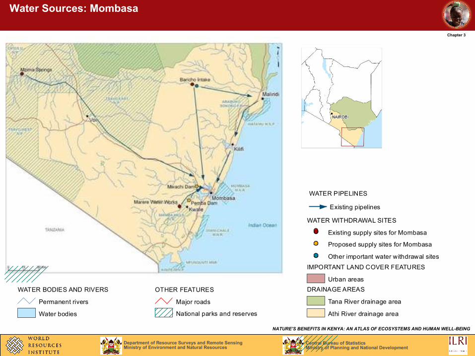
Water Sources: Mombasa
WATER PIPELINES
Existing pipelines
WATER WITHDRAWAL SITES
Existing supply sites for Mombasa
Proposed supply sites for Mombasa
Other important water withdrawal sites
IMPORTANT LAND COVER FEATURES
Urban areas
DRAINAGE AREAS
Tana River drainage area
Athi River drainage area
OTHER FEATURES
Major roads
National parks and reserves
WATER BODIES AND RIVERS
Permanent rivers
Water bodies
Central Bureau of StatisticsMinistry of Planning and National Development
Department of Resource Surveys and Remote SensingMinistry of Environment and Natural Resources
NATURE’S BENEFITS IN KENYA: AN ATLAS OF ECOSYSTEMS AND HUMAN WELL-BEING
Chapter 3
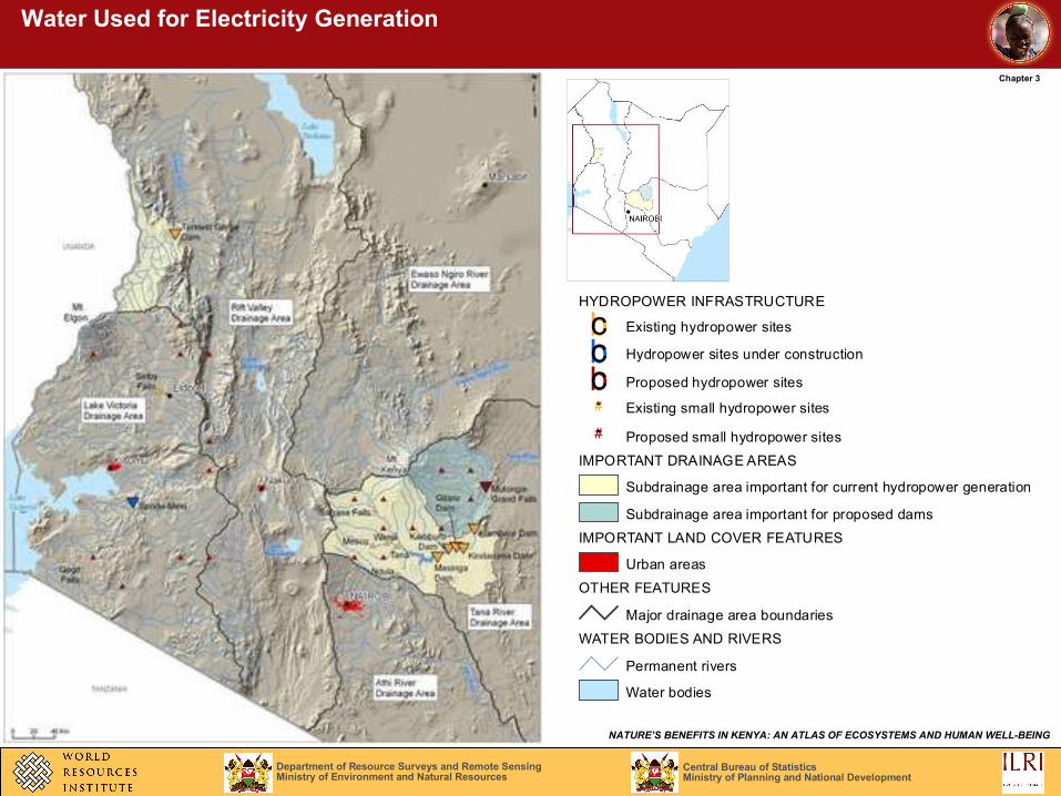
Water Used for Electricity Generation
HYDROPOWER INFRASTRUCTURE
bc Existing hydropower sites
bc Hydropower sites under construction
bc Proposed hydropower sites
#* Existing small hydropower sites
#* Proposed small hydropower sites
IMPORTANT DRAINAGE AREAS
Subdrainage area important for current hydropower generation
Subdrainage area important for proposed dams
IMPORTANT LAND COVER FEATURES
Urban areas
OTHER FEATURES
Major drainage area boundaries
WATER BODIES AND RIVERS
Permanent rivers
Water bodies
Central Bureau of StatisticsMinistry of Planning and National Development
Department of Resource Surveys and Remote SensingMinistry of Environment and Natural Resources
NATURE’S BENEFITS IN KENYA: AN ATLAS OF ECOSYSTEMS AND HUMAN WELL-BEING
Chapter 3
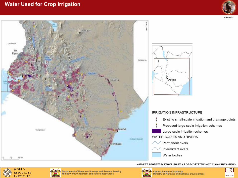
Water Used for Crop Irrigation
IRRIGATION INFRASTRUCTURE
") Existing small-scale irrigation and drainage points
") Proposed large-scale irrigation schemes
Large-scale irrigation schemes
WATER BODIES AND RIVERS
Permanent rivers
Intermittent rivers
Water bodies
Central Bureau of StatisticsMinistry of Planning and National Development
Department of Resource Surveys and Remote SensingMinistry of Environment and Natural Resources
NATURE’S BENEFITS IN KENYA: AN ATLAS OF ECOSYSTEMS AND HUMAN WELL-BEING
Chapter 3
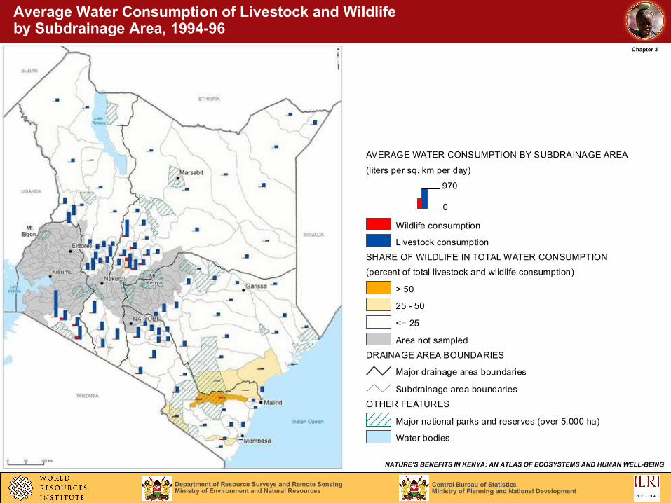
Average Water Consumption of Livestock and Wildlife by Subdrainage Area, 1994-96
AVERAGE WATER CONSUMPTION BY SUBDRAINAGE AREA
(liters per sq. km per day)
970
0
Wildlife consumption
Livestock consumption
SHARE OF WILDLIFE IN TOTAL WATER CONSUMPTION
(percent of total livestock and wildlife consumption)
> 50
25 - 50
<= 25
Area not sampled
DRAINAGE AREA BOUNDARIES
Subdrainage area boundaries
OTHER FEATURES
Major national parks and reserves (over 5,000 ha)
Water bodies
Major drainage area boundaries
Central Bureau of StatisticsMinistry of Planning and National Development
Department of Resource Surveys and Remote SensingMinistry of Environment and Natural Resources
NATURE’S BENEFITS IN KENYA: AN ATLAS OF ECOSYSTEMS AND HUMAN WELL-BEING
Chapter 3
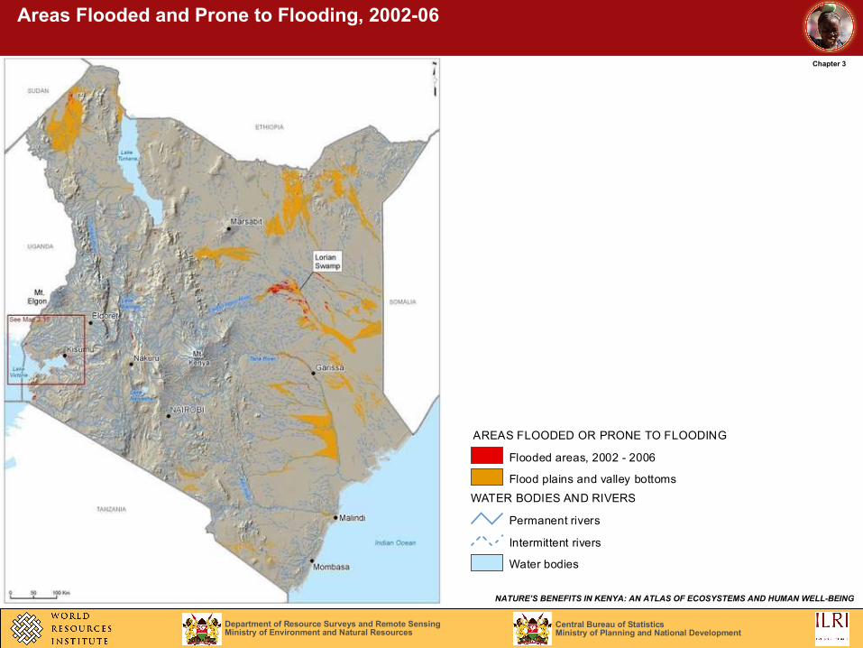
Areas Flooded and Prone to Flooding, 2002-06
AREAS FLOODED OR PRONE TO FLOODING
Flooded areas, 2002 - 2006
Flood plains and valley bottoms
WATER BODIES AND RIVERS
Permanent rivers
Intermittent rivers
Water bodies
Central Bureau of StatisticsMinistry of Planning and National Development
Department of Resource Surveys and Remote SensingMinistry of Environment and Natural Resources
NATURE’S BENEFITS IN KENYA: AN ATLAS OF ECOSYSTEMS AND HUMAN WELL-BEING
Chapter 3
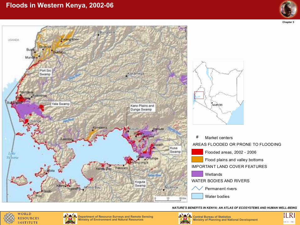
Floods in Western Kenya, 2002-06
# Market centers
AREAS FLOODED OR PRONE TO FLOODING
Flooded areas, 2002 - 2006
Flood plains and valley bottoms
IMPORTANT LAND COVER FEATURES
Wetlands
WATER BODIES AND RIVERS
Permanent rivers
Water bodies
Central Bureau of StatisticsMinistry of Planning and National Development
Department of Resource Surveys and Remote SensingMinistry of Environment and Natural Resources
NATURE’S BENEFITS IN KENYA: AN ATLAS OF ECOSYSTEMS AND HUMAN WELL-BEING
Chapter 3
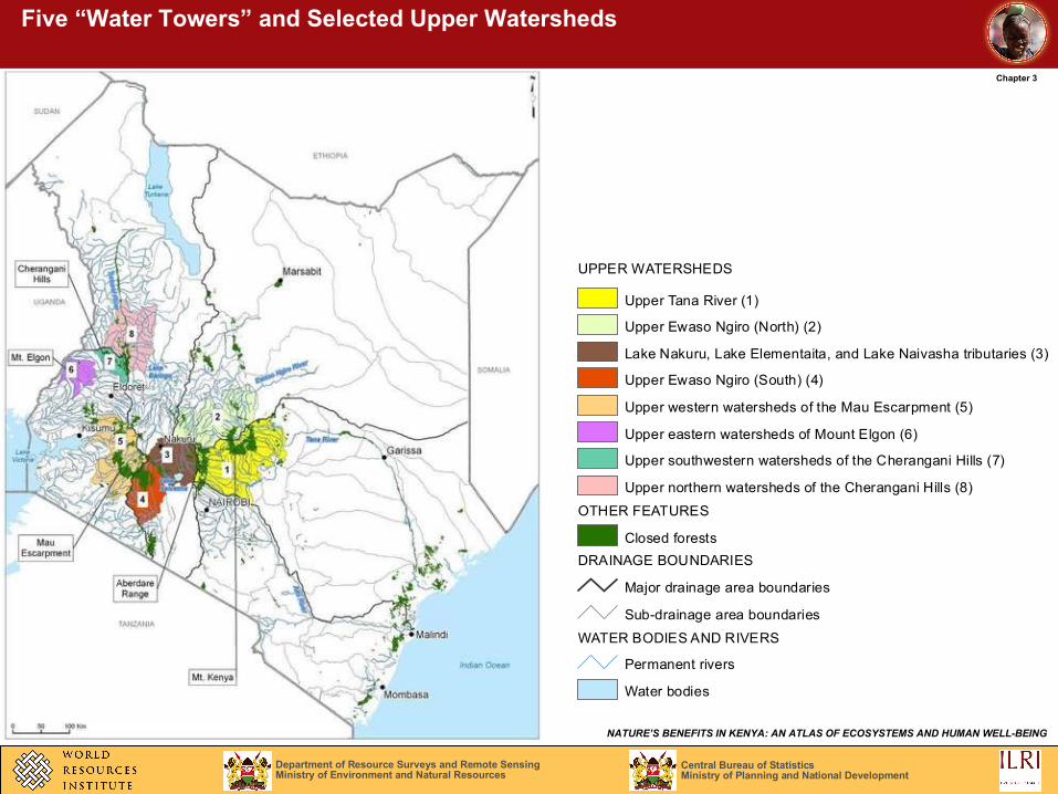
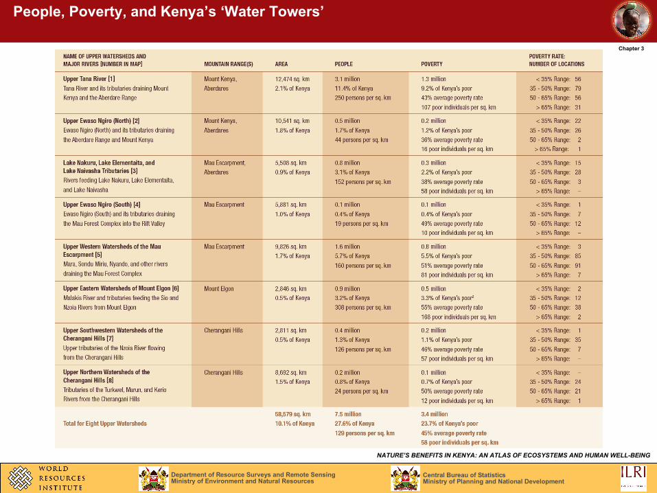
Five “Water Towers” and Selected Upper Watersheds
UPPER WATERSHEDS
Upper Tana River (1)
Upper Ewaso Ngiro (North) (2)
Lake Nakuru, Lake Elementaita, and Lake Naivasha tributaries (3)
Upper Ewaso Ngiro (South) (4)
Upper western watersheds of the Mau Escarpment (5)
Upper eastern watersheds of Mount Elgon (6)
Upper southwestern watersheds of the Cherangani Hills (7)
Upper northern watersheds of the Cherangani Hills (8)
OTHER FEATURES
Closed forests
DRAINAGE BOUNDARIES
Major drainage area boundaries
Sub-drainage area boundaries
WATER BODIES AND RIVERS
Permanent rivers
Water bodies
Central Bureau of StatisticsMinistry of Planning and National Development
Department of Resource Surveys and Remote SensingMinistry of Environment and Natural Resources
NATURE’S BENEFITS IN KENYA: AN ATLAS OF ECOSYSTEMS AND HUMAN WELL-BEING
Chapter 3
People, Poverty, and Kenya’s ‘Water Towers’