Embed Size (px)
Citation preview
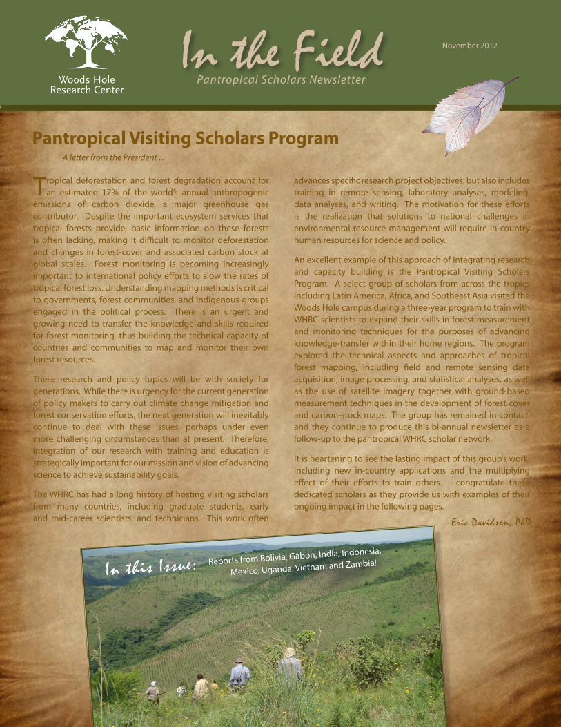
Tropical deforestation and forest degradation account for an estimated 17% of the world’s annual anthropogenic
emissions of carbon dioxide, a major greenhouse gas contributor. Despite the important ecosystem services that tropical forests provide, basic information on these forests is often lacking, making it difficult to monitor deforestation and changes in forest-cover and associated carbon stock at global scales. Forest monitoring is becoming increasingly important to international policy efforts to slow the rates of tropical forest loss. Understanding mapping methods is critical to governments, forest communities, and indigenous groups engaged in the political process. There is an urgent and growing need to transfer the knowledge and skills required for forest monitoring, thus building the technical capacity of countries and communities to map and monitor their own forest resources.
These research and policy topics will be with society for generations. While there is urgency for the current generation of policy makers to carry out climate change mitigation and forest conservation efforts, the next generation will inevitably continue to deal with these issues, perhaps under even more challenging circumstances than at present. Therefore, integration of our research with training and education is strategically important for our mission and vision of advancing science to achieve sustainability goals.
The WHRC has had a long history of hosting visiting scholars from many countries, including graduate students, early and mid-career scientists, and technicians. This work often
November 2012In the FieldPantropical Visiting Scholars Program
A letter from the President ...
Pantropical Scholars NewsletterWoods HoleResearch Center
In this Issue:
Eric Davidson, PhD
Reports from Bolivia, Gabon, India, Indonesia,
Mexico, Uganda, Vietnam and Zambia!
advances specific research project objectives, but also includes training in remote sensing, laboratory analyses, modeling, data analyses, and writing. The motivation for these efforts is the realization that solutions to national challenges in environmental resource management will require in-country human resources for science and policy.
An excellent example of this approach of integrating research and capacity building is the Pantropical Visiting Scholars Program. A select group of scholars from across the tropics including Latin America, Africa, and Southeast Asia visited the Woods Hole campus during a three-year program to train with WHRC scientists to expand their skills in forest measurement and monitoring techniques for the purposes of advancing knowledge-transfer within their home regions. The program explored the technical aspects and approaches of tropical forest mapping, including field and remote sensing data acquisition, image processing, and statistical analyses, as well as the use of satellite imagery together with ground-based measurement techniques in the development of forest cover and carbon-stock maps. The group has remained in contact, and they continue to produce this bi-annual newsletter as a follow-up to the pantropical WHRC scholar network.
It is heartening to see the lasting impact of this group’s work, including new in-country applications and the multiplying effect of their efforts to train others. I congratulate these dedicated scholars as they provide us with examples of their ongoing impact in the following pages.
Dear Scholars,
I have some good news from the NASA Earth Science Division! Our project, Forest Carbon Assessment for REDD in the East Africa SERVIR Region, has been funded by the Applied Sciences Program and will run from October 2012 to September 2016.
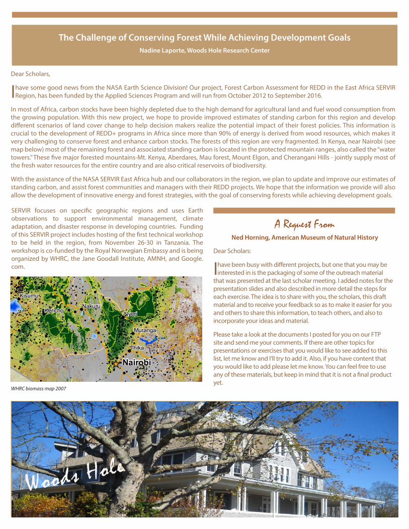
In most of Africa, carbon stocks have been highly depleted due to the high demand for agricultural land and fuel wood consumption from the growing population. With this new project, we hope to provide improved estimates of standing carbon for this region and develop different scenarios of land cover change to help decision makers realize the potential impact of their forest policies. This information is crucial to the development of REDD+ programs in Africa since more than 90% of energy is derived from wood resources, which makes it very challenging to conserve forest and enhance carbon stocks. The forests of this region are very fragmented. In Kenya, near Nairobi (see map below) most of the remaining forest and associated standing carbon is located in the protected mountain ranges, also called the “water towers.” These five major forested mountains-Mt. Kenya, Aberdares, Mau forest, Mount Elgon, and Cherangani Hills - jointly supply most of the fresh water resources for the entire country and are also critical reservoirs of biodiversity.
With the assistance of the NASA SERVIR East Africa hub and our collaborators in the region, we plan to update and improve our estimates of standing carbon, and assist forest communities and managers with their REDD projects. We hope that the information we provide will also allow the development of innovative energy and forest strategies, with the goal of conserving forests while achieving development goals.
A Request From Ned Horning, American Museum of Natural History
Dear Scholars:
I have been busy with different projects, but one that you may be interested in is the packaging of some of the outreach material
that was presented at the last scholar meeting. I added notes for the presentation slides and also described in more detail the steps for each exercise. The idea is to share with you, the scholars, this draft material and to receive your feedback so as to make it easier for you and others to share this information, to teach others, and also to incorporate your ideas and material.
Please take a look at the documents I posted for you on our FTP site and send me your comments. If there are other topics for presentations or exercises that you would like to see added to this list, let me know and I’ll try to add it. Also, if you have content that you would like to add please let me know. You can feel free to use any of these materials, but keep in mind that it is not a final product yet.
The Challenge of Conserving Forest While Achieving Development Goals Nadine Laporte, Woods Hole Research Center
WHRC biomass map 2007
SERVIR focuses on specific geographic regions and uses Earth observations to support environmental management, climate adaptation, and disaster response in developing countries. Funding of this SERVIR project includes hosting of the first technical workshop to be held in the region, from November 26-30 in Tanzania. The workshop is co-funded by the Royal Norwegian Embassy and is being organized by WHRC, the Jane Goodall Institute, AMNH, and Google.com.
Woods Hole
Structural Characterization of Forest Diversity with Remote Sensing in Mexico
Isabel Trejo, National Commission for the Knowledge and Use of Biodiversity (CONABIO)
I am currently developing the protocol for my dissertation, which is called “Structural characterization of forest diversity in Mexico
through remote sensing: An Approach to Biodiversity.” The training I received at WHRC motivated me and gave me the skills and tools necessary to undertake such an analysis.
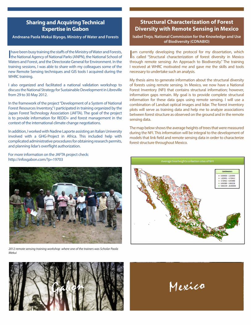
My thesis aims to generate information about the structural diversity of forests using remote sensing. In Mexico, we now have a National Forest Inventory (NFI) that contains structural information; however, information gaps remain. My goal is to provide complete structural information for these data gaps using remote sensing. I will use a combination of Landsat optical images and lidar. The forest inventory plots will serve as training data and help me to analyze associations between forest structure as observed on the ground and in the remote sensing data.
The map below shows the average heights of trees that were measured during the NFI. This information will be integral to the development of models that link field and remote sensing data in order to characterize forest structure throughout Mexico.
MexicoGabon
Sharing and Acquiring Technical Expertise in Gabon
Andreana Paola Mekui Biyogo, Ministry of Water and Forests
I have been busy training the staffs of the Ministry of Water and Forests, the National Agency of National Parks (ANPN), the National School of
Waters and Forest, and the Directorate General for Environment. In the training sessions, I was able to share with my colleagues some of the new Remote Sensing techniques and GIS tools I acquired during the WHRC training.
I also organized and facilitated a national validation workshop to discuss the National Strategy for Sustainable Development in Libreville from 29 to 30 May 2012.
In the framework of the project “Development of a System of National Forest Resources Inventory,” I participated in training organized by the Japan Forest Technology Association (JAFTA). The goal of the project is to provide information for REDD+ and forest management in the context of the international climate change negotiations.
In addition, I worked with Nadine Laporte assisting an Italian University involved with a GHG-Project in Africa. This included help with complicated administrative procedures for obtaining research permits, and planning lidar’s overflight authorization.
For more information on the JAFTA project check: http://infosgabon.com/?p=19703
2012 remote sensing training workshop where one of the trainers was Scholar Paola Mekui
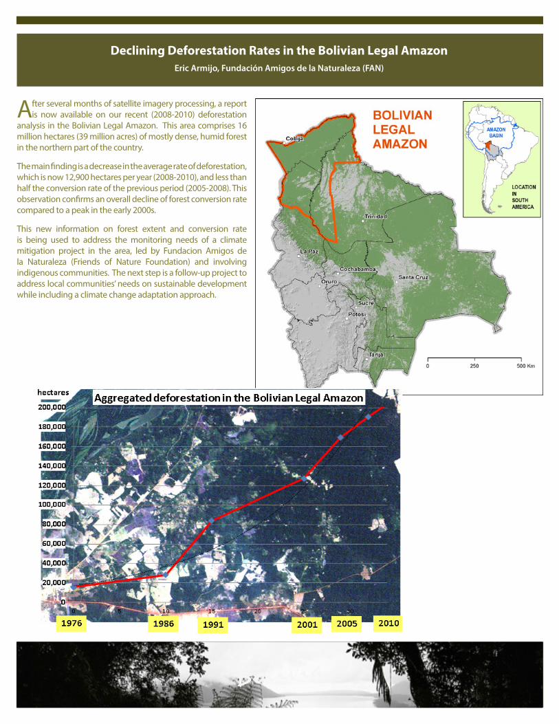
After several months of satellite imagery processing, a report is now available on our recent (2008-2010) deforestation
analysis in the Bolivian Legal Amazon. This area comprises 16 million hectares (39 million acres) of mostly dense, humid forest in the northern part of the country.
The main finding is a decrease in the average rate of deforestation, which is now 12,900 hectares per year (2008-2010), and less than half the conversion rate of the previous period (2005-2008). This observation confirms an overall decline of forest conversion rate compared to a peak in the early 2000s.
This new information on forest extent and conversion rate is being used to address the monitoring needs of a climate mitigation project in the area, led by Fundacion Amigos de la Naturaleza (Friends of Nature Foundation) and involving indigenous communities. The next step is a follow-up project to address local communities’ needs on sustainable development while including a climate change adaptation approach.
Bolivia
Declining Deforestation Rates in the Bolivian Legal AmazonEric Armijo, Fundación Amigos de la Naturaleza (FAN)
Since my return from WHRC, I have been focusing on several research questions related to climate change in forest communities: what is the effect of climate change on communities around the forest? How vulnerable are they and their living environment
to climate change? What are their adaptation strategies, and how much is the fund allocation for climate change adaptation at the community level? These questions form the basis of the project I have been working on this year.
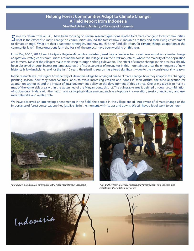
From May 10-16, 2012, I went to Apui village in Minyambouw district, West Papua Province, to conduct research about climate change adaptation strategies of communities around the forest. The village lies in the Arfak mountains, where the majority of the population are farmers. Most of the villagers make their living through shifting cultivation. The effect of climate change in this area has already been observed through increasing temperatures; the first occurences of mosquitos in this mountainous area; the emergence of new, historically lowland plants; and for the last 10 years, the planting season has altered significantly due to the inconsistent rainy season.
In this research, we investigate how the way of life in this village has changed due to climate change, how they adapt to the changing planting season, how they conserve their lands to avoid increasing erosion and floods in their district, the fund allocation for adaptation strategies, and the impact of local government policy on the development of this district. One of my tasks is to make a map of the vulnerable area within the watershed of the Minyambouw district. The vulnerable area is defined through a combination of socioeconomic data with thematic maps for biophysical parameters, such as a topography, elevation, erosion, land cover, land use, river networks, and rainfall data.
We have observed an interesting phenomenon in the field: the people in the village are still not aware of climate change or the importance of forest conservation; they just live life in the moment, with its ups and downs. We still have a lot of work to do here!
Helping Forest Communities Adapt to Climate Change: A Field Report from Indonesia
Virni Budi Arifanti, Ministry of Forestry of Indonesia
Indonesia
Apui village, a small forest community in the Arfak mountains in Indonesia. Virni and her team interview villagers and farmers about how the changing climate has affected their way of life.
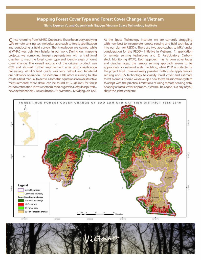
Mapping Forest Cover Type and Forest Cover Change in Vietnam Giang Nguyen Vu and Quyen Hanh Nguyen, Vietnam Space Technology Institute
Since returning from WHRC, Quyen and I have been busy applying a remote sensing technological approach to forest stratification
and conducting a field survey. The knowledge we gained while at WHRC was definitely helpful in our work. During our mapping projects, we combined image segmentation with a traditional classifier to map the forest cover type and identify areas of forest cover change. The overall accuracy of the original product was 82% and showed further improvement after post classification processing. WHRC’s field guide was very helpful and facilitated our fieldwork operation. The Vietnam REDD office is aiming to also create a field manual to derive allometric equations from destructive measurements; more detail can be found at Guidelines for forest carbon estimation (http://vietnam-redd.org/Web/Default.aspx?tab=newsdetail&zoneid=107&subzone=157&itemid=426&lang=en-US).
At the Space Technology Institute, we are currently struggling with how best to incorporate remote sensing and field techniques into our plan for REDD+. There are two approaches to MRV under consideration for the REDD+ initiative in Vietnam: 1) application of remote sensing techniques and 2) Participatory Carbon-stock Monitoring (PCM). Each approach has its own advantages and disadvantages; the remote sensing approach seems to be appropriate for national scale modeling, while PCM is suitable for the project level. There are many possible methods to apply remote sensing and GIS technology to classify forest cover and estimate forest biomass. Should we develop a new forest classification system to adapt with the practical limitations of using remote sensing data, or apply a fractal cover approach, as WHRC has done? Do any of you share the same concern?
Vietnam

Since February 2012, most of our time has been spent preparing for the forthcoming visit of the World Bank and site validators
from Germany. The purpose of their visit is to verify four CDM project areas in southwestern Uganda and all efforts have been aimed at ensuring that this verification goes well so that we may receive the first carbon credits at the end of the year. With my colleagues at the National Forest Authority (NFA), we led several staff trainings as well as a number of mapping activities, including:
• Training all staff participating in the CDM projects in:
• Protocols to be followed when mapping
• Protocols to be followed in plot measurement
• Hands-on use of the GPS receivers
• Plot data entry in the field form and thereafter into the computer
• Management of GPS data (e.g., upload, download, cleaning and integration into GIS)
• Mapping and stratifying the tree crop
• Measurement of sample plots in the various strata
• Quality control of trees inventory data, and project area boundaries
• Emissions reduction calculations
• Finalizing and submitting all required documents in April
• Final field and administrative preparations for the arrival of the CDM validators on 29 May 2012
One of the major concerns of the validation exercise was the physical demarcation of about 80km of project area boundaries on the ground in five projects. Marking the entire 80km would be too expensive for NFA, so I used my skills and open source software (Spring and the Landsat gap filler) acquired from WHRC to generate maps that were used to explore the lowest cost options possible. Eventually the cheapest was selected and used as part of the Corrective Action Requests for the CDM compliance.
Additionally, the Uganda National Forest Authority hosted a training (21-19 May) on the use of ERDAS software. It was conducted by Oaker Services of Nairobi, Kenya.
Clean Development Mechanism (CDM) Project Area Verification in Uganda
Edward Ssenyonjo, Uganda National Forest Authority
Uganda
I spent the last months of 2011 and early 2012 modeling future forest change for the Murchison-Semliki landscape. Forest cover
of 1995, 2005 and 2010 were used. Drivers used included a Digital Elevation Model, roads, distance to market, distance to village, protection status (protected or not protected) and distance to rivers. The Land Change Modeling extension of the Idrisi software was used. During this analysis, the land change modeling training obtained at WHRC enabled me to make better informed decisions and interpretation of obtained results. The outputs are being used in the Project Design Document (PDD) for this landscape for a REDD project.
I am now preparing datasets for the modeling of species response to climate change in the Albertine rift. The analysis will cover plants, birds, and mammals.
Modeling Forest Change in UgandaGrace Nangendo , Wildlife Conservation Society
The figure shows the transition potential of forest cover in the Murchison-Semliki land-scape. The legend indicates the probability of any area changing from forest to another land cover type. Higher values indicate higher probabilities of forest loss.
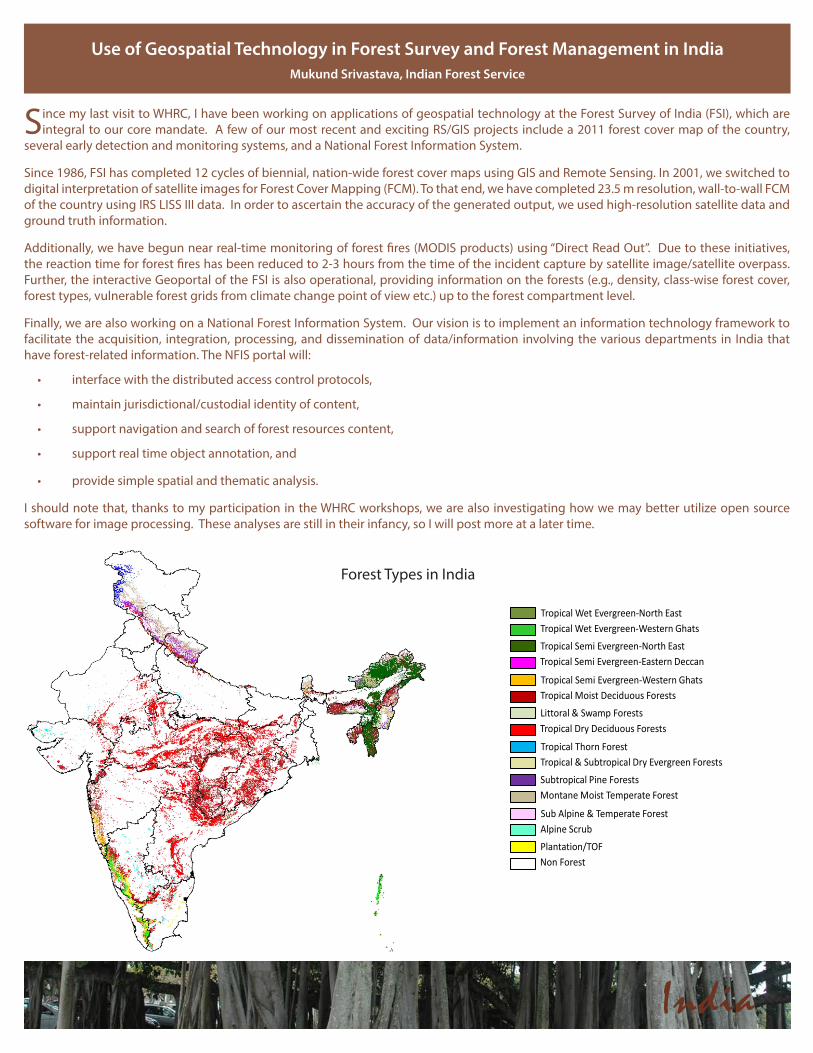
Since my last visit to WHRC, I have been working on applications of geospatial technology at the Forest Survey of India (FSI), which are integral to our core mandate. A few of our most recent and exciting RS/GIS projects include a 2011 forest cover map of the country,
several early detection and monitoring systems, and a National Forest Information System.
Since 1986, FSI has completed 12 cycles of biennial, nation-wide forest cover maps using GIS and Remote Sensing. In 2001, we switched to digital interpretation of satellite images for Forest Cover Mapping (FCM). To that end, we have completed 23.5 m resolution, wall-to-wall FCM of the country using IRS LISS III data. In order to ascertain the accuracy of the generated output, we used high-resolution satellite data and ground truth information.
Additionally, we have begun near real-time monitoring of forest fires (MODIS products) using “Direct Read Out”. Due to these initiatives, the reaction time for forest fires has been reduced to 2-3 hours from the time of the incident capture by satellite image/satellite overpass. Further, the interactive Geoportal of the FSI is also operational, providing information on the forests (e.g., density, class-wise forest cover, forest types, vulnerable forest grids from climate change point of view etc.) up to the forest compartment level.
Finally, we are also working on a National Forest Information System. Our vision is to implement an information technology framework to facilitate the acquisition, integration, processing, and dissemination of data/information involving the various departments in India that have forest-related information. The NFIS portal will:
• interface with the distributed access control protocols,
• maintain jurisdictional/custodial identity of content,
• support navigation and search of forest resources content,
• support real time object annotation, and
• provide simple spatial and thematic analysis.
I should note that, thanks to my participation in the WHRC workshops, we are also investigating how we may better utilize open source software for image processing. These analyses are still in their infancy, so I will post more at a later time.
Use of Geospatial Technology in Forest Survey and Forest Management in IndiaMukund Srivastava, Indian Forest Service
Tropical Wet Evergreen-North EastTropical Wet Evergreen-Western Ghats
Tropical Semi Evergreen-North EastTropical Semi Evergreen-Eastern Deccan
Tropical Semi Evergreen-Western GhatsTropical Moist Deciduous Forests
Littoral & Swamp ForestsTropical Dry Deciduous Forests
Tropical Thorn ForestTropical & Subtropical Dry Evergreen Forests
Subtropical Pine ForestsMontane Moist Temperate Forest
Sub Alpine & Temperate ForestAlpine Scrub
Plantation/TOFNon Forest
India
Forest Types in India
Developing a Forest Inventory Design for ZambiaAbel Siampale and Sitwala Wamunyime, Zambia Forestry Department
Since November 2011, we have been extremely busy planning and conducting pre-assessment forest inventories over some
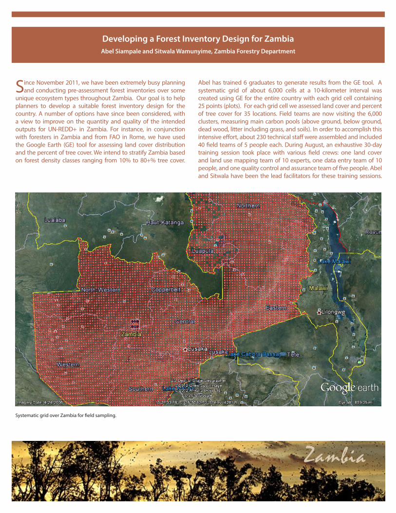
unique ecosystem types throughout Zambia. Our goal is to help planners to develop a suitable forest inventory design for the country. A number of options have since been considered, with a view to improve on the quantity and quality of the intended outputs for UN-REDD+ in Zambia. For instance, in conjunction with foresters in Zambia and from FAO in Rome, we have used the Google Earth (GE) tool for assessing land cover distribution and the percent of tree cover. We intend to stratify Zambia based on forest density classes ranging from 10% to 80+% tree cover.
Zambia
Systematic grid over Zambia for field sampling.
Abel has trained 6 graduates to generate results from the GE tool. A systematic grid of about 6,000 cells at a 10-kilometer interval was created using GE for the entire country with each grid cell containing 25 points (plots). For each grid cell we assessed land cover and percent of tree cover for 35 locations. Field teams are now visiting the 6,000 clusters, measuring main carbon pools (above ground, below ground, dead wood, litter including grass, and soils). In order to accomplish this intensive effort, about 230 technical staff were assembled and included 40 field teams of 5 people each. During August, an exhaustive 30-day training session took place with various field crews: one land cover and land use mapping team of 10 experts, one data entry team of 10 people, and one quality control and assurance team of five people. Abel and Sitwala have been the lead facilitators for these training sessions.
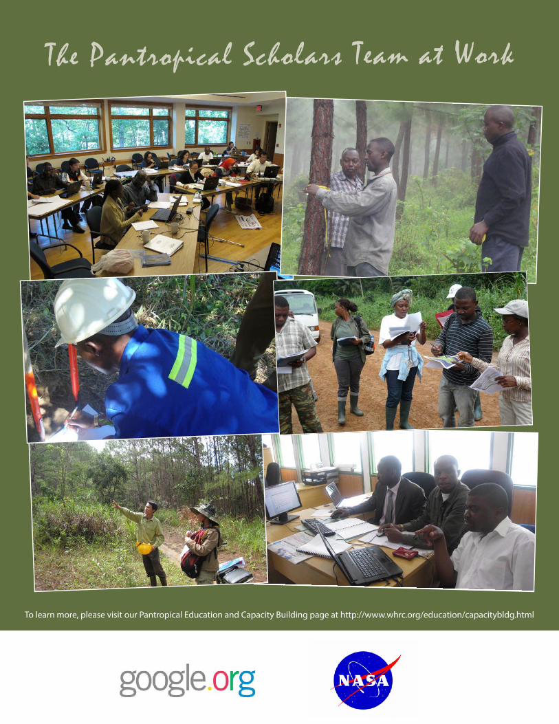
The Pantropical Scholars Team at Work
To learn more, please visit our Pantropical Education and Capacity Building page at http://www.whrc.org/education/capacitybldg.html
Program Director: Nadine Laporte, PhD Program Coordinator: Tina Cormier, MS Editors: Tina Cormier and Beth Bagley
Design: Ian Vorster, Director of Communications and Denise Kergo, Web Developer
www.whrc.org
The Woods Hole Research Center (WHRC) is a private, non-profit research organization focussing on environmental sciences. Our scientists combine analysis of satellite images of the Earth with field studies to measure, model, and map changes in the world’s ecosystems, from the thawing permafrost in the Arctic to the expanding agriculture regions of the tropics. We work locally and regionally, with in-depth expertise and collaborations in North and South America and Africa; and we also work globally, focussing on how humans are changing global cycles of carbon, nitrogen, and water. We merge natural science with economics to discover sustainable paths for human prosperity and stewardship of the Earth’s natural resources.
Our mission is to advance scientific discovery and seek science-based solutions for the world’s environmental and economic challenges through research and education on forests, soils, air, and water.
Our vision is a world in which the insights of science guide management of the Earth’s natural resources, so that we and future generations may sustain prosperous and fulfilling lives without degrading the ecosystems that support humanity and a diverse abundance of life.