Embed Size (px)
Citation preview
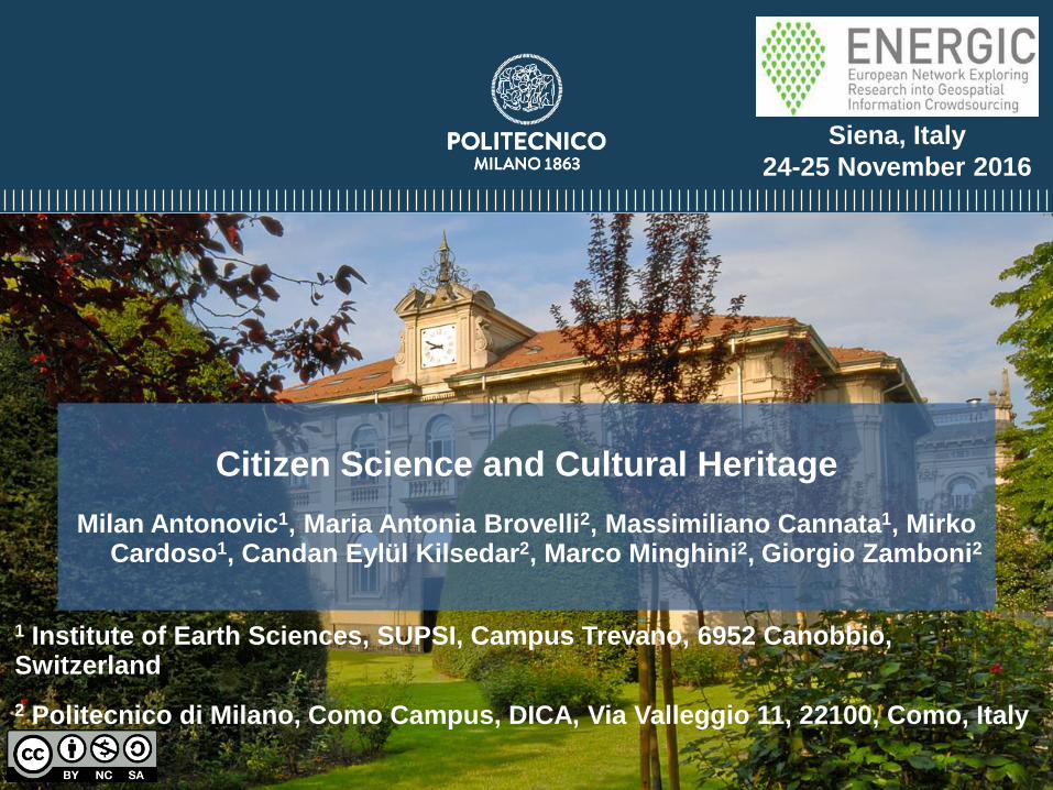
Citizen Science and Cultural Heritage
Milan Antonovic1, Maria Antonia Brovelli2, Massimiliano Cannata1, Mirko Cardoso1, Candan Eylül Kilsedar2, Marco Minghini2, Giorgio Zamboni2
1 Institute of Earth Sciences, SUPSI, Campus Trevano, 6952 Canobbio, Switzerland
2 Politecnico di Milano, Como Campus, DICA, Via Valleggio 11, 22100, Como, Italy
Siena, Italy
24-25 November 2016
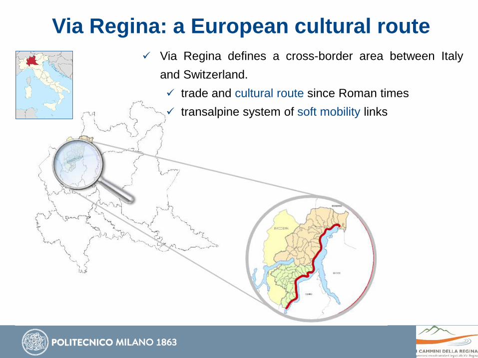
Via Regina: a European cultural route
Via Regina defines a cross-border area between Italy
and Switzerland.
trade and cultural route since Roman times
transalpine system of soft mobility links
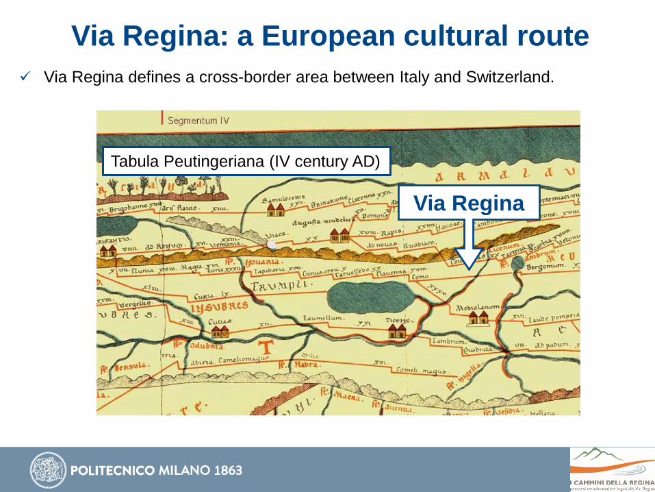
Via Regina: a European cultural route
Via Regina defines a cross-border area between Italy and Switzerland.
Via Regina
Tabula Peutingeriana (IV century AD)
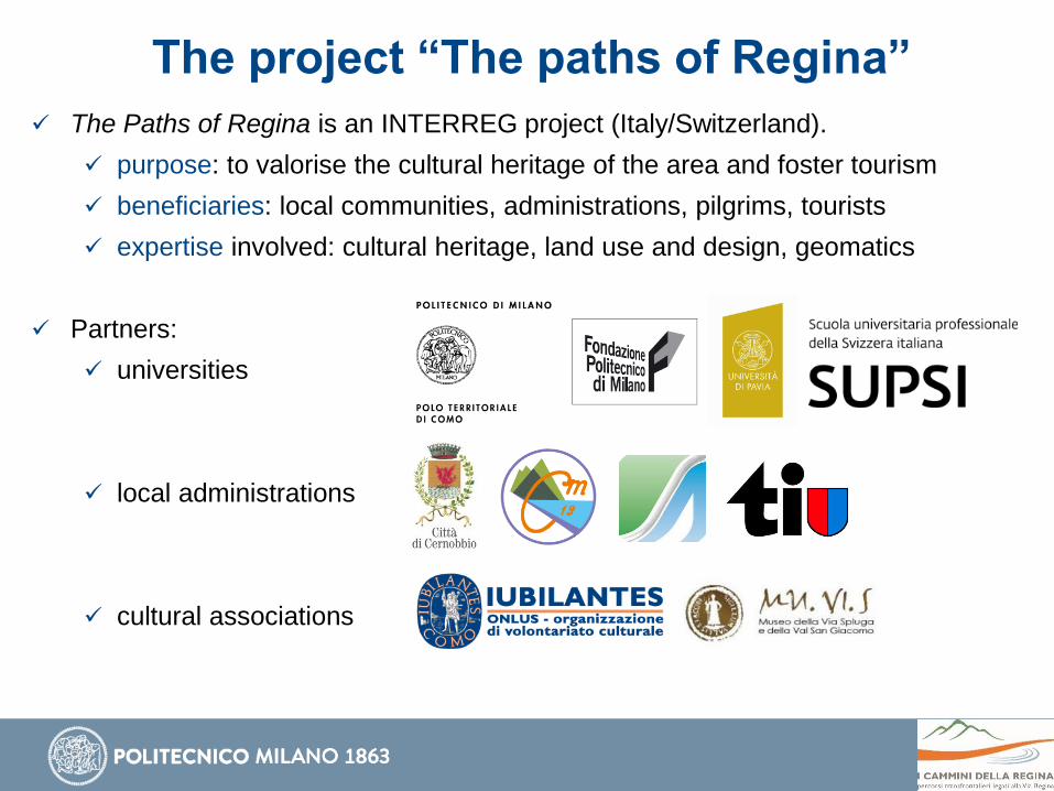
The project “The paths of Regina”
The Paths of Regina is an INTERREG project (Italy/Switzerland).
purpose: to valorise the cultural heritage of the area and foster tourism
beneficiaries: local communities, administrations, pilgrims, tourists
expertise involved: cultural heritage, land use and design, geomatics
Partners:
universities
local administrations
cultural associations

Slow tourism at a glance
Slow tourism (a special kind of sustainable tourism) involves:
environmental friendliness
rediscovery of local traditions and cultural knowledge
movement (no car/plane)
sustainability gastronomy (local)
culture leisure (peaceful)
simple accommodationservices (provided in a
relaxing environment)
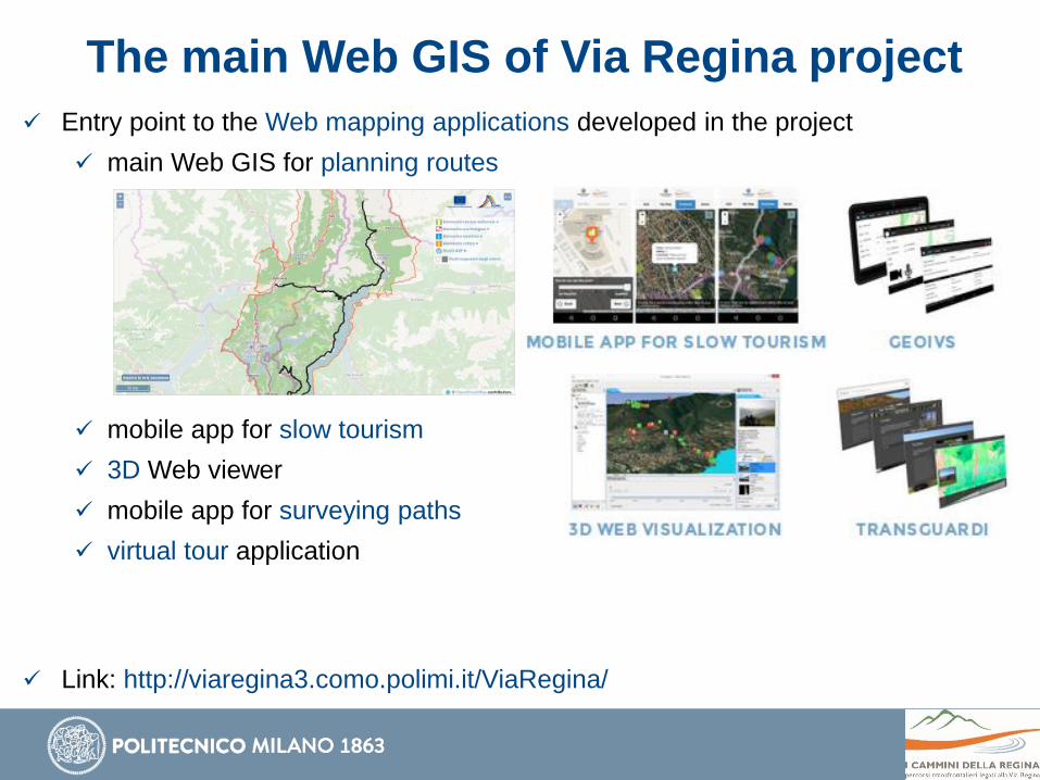
The main Web GIS of Via Regina project
Entry point to the Web mapping applications developed in the project
main Web GIS for planning routes
mobile app for slow tourism
3D Web viewer
mobile app for surveying paths
virtual tour application
Link: http://viaregina3.como.polimi.it/ViaRegina/
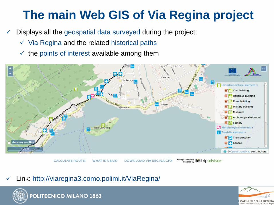
The main Web GIS of Via Regina project
Displays all the geospatial data surveyed during the project:
Via Regina and the related historical paths
the points of interest available among them
Link: http://viaregina3.como.polimi.it/ViaRegina/

The main Web GIS of Via Regina project
Displays all the geospatial data surveyed during the project:
Via Regina and the related historical paths
the points of interest available among them
Link: http://viaregina3.como.polimi.it/ViaRegina/
The main Web GIS of Via Regina project
Displays the bus routes and bus stops in the project area
kindly provided by ASF Autolinee
each bus stop has the link to its real time schedule
Link: http://viaregina3.como.polimi.it/ViaRegina/
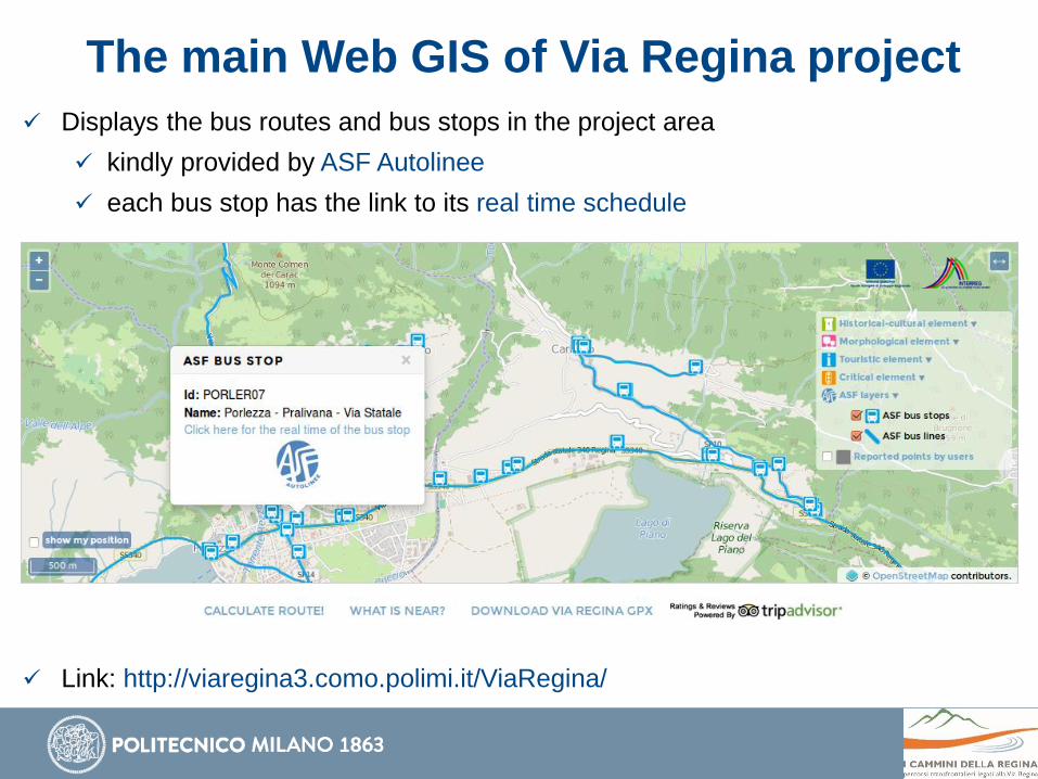
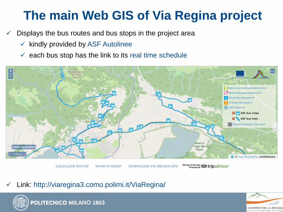
The main Web GIS of Via Regina project
Displays the bus routes and bus stops in the project area
kindly provided by ASF Autolinee
each bus stop has the link to its real time schedule
Link: http://viaregina3.como.polimi.it/ViaRegina/
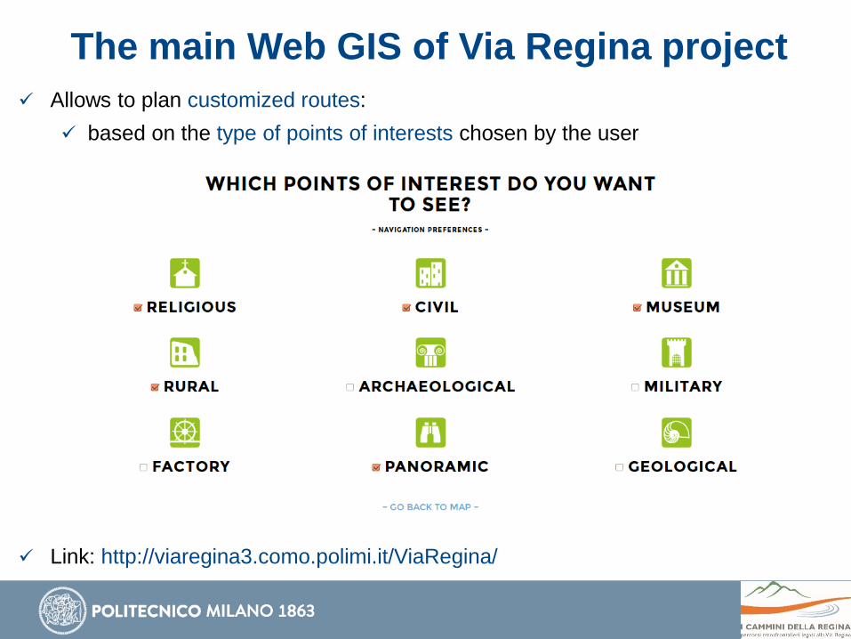
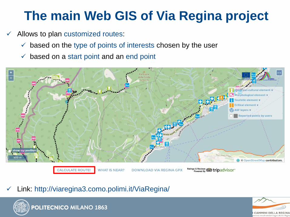
The main Web GIS of Via Regina project
Allows to plan customized routes:
based on the type of points of interests chosen by the user
Link: http://viaregina3.como.polimi.it/ViaRegina/
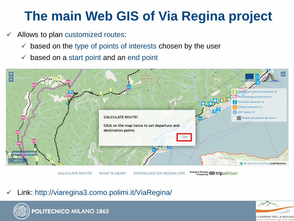
The main Web GIS of Via Regina project
Allows to plan customized routes:
based on the type of points of interests chosen by the user
based on a start point and an end point
Link: http://viaregina3.como.polimi.it/ViaRegina/
The main Web GIS of Via Regina project
Allows to plan customized routes:
based on the type of points of interests chosen by the user
based on a start point and an end point
Link: http://viaregina3.como.polimi.it/ViaRegina/

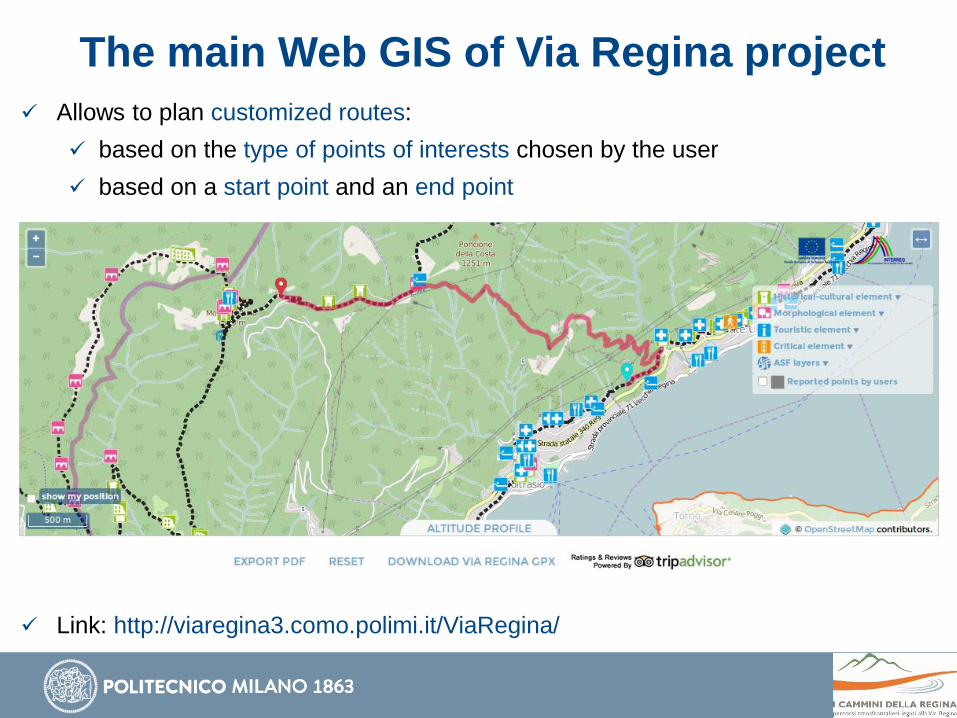
The main Web GIS of Via Regina project
Allows to plan customized routes:
based on the type of points of interests chosen by the user
based on a start point and an end point
Link: http://viaregina3.como.polimi.it/ViaRegina/
The main Web GIS of Via Regina project
Allows to plan customized routes:
based on the type of points of interests chosen by the user
based on a start point and an end point
Link: http://viaregina3.como.polimi.it/ViaRegina/

The main Web GIS of Via Regina project
Allows to plan customized routes:
based on the type of points of interests chosen by the user
based on a start point and an end point
Link: http://viaregina3.como.polimi.it/ViaRegina/
The main Web GIS of Via Regina project
Allows to plan customized routes:
based on the type of points of interests chosen by the user
based on a start point and an end point
Link: http://viaregina3.como.polimi.it/ViaRegina/

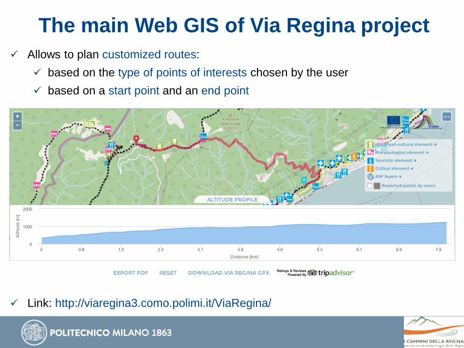
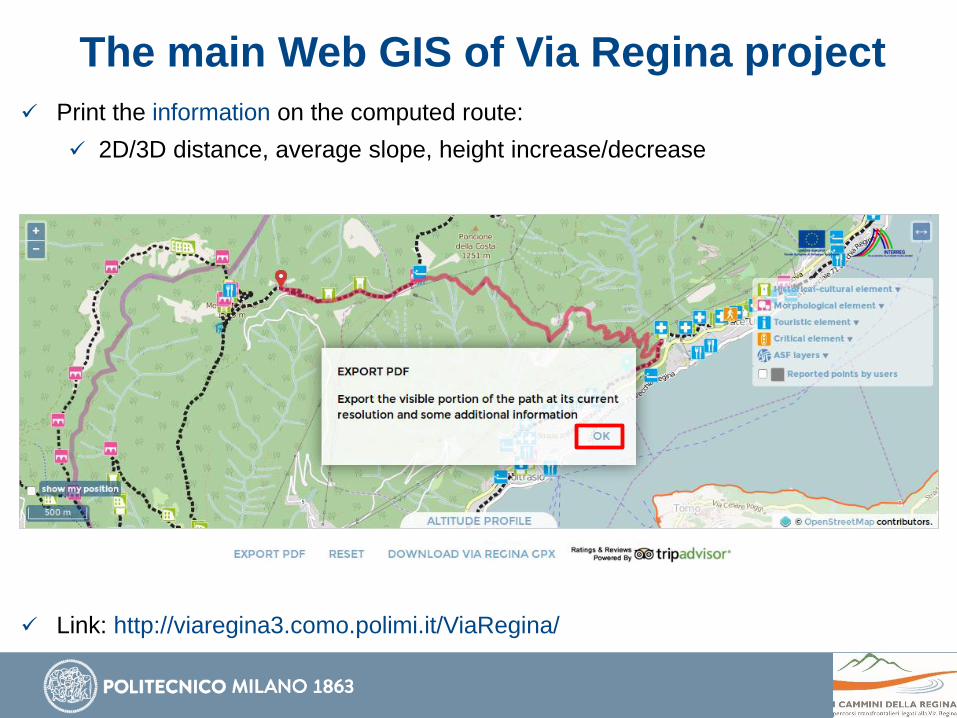
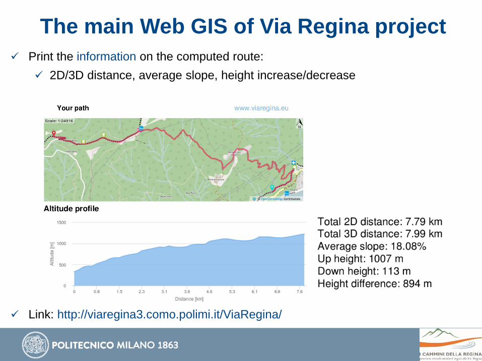
The main Web GIS of Via Regina project
Print the information on the computed route:
2D/3D distance, average slope, height increase/decrease
Link: http://viaregina3.como.polimi.it/ViaRegina/
The main Web GIS of Via Regina project
Print the information on the computed route:
2D/3D distance, average slope, height increase/decrease
Link: http://viaregina3.como.polimi.it/ViaRegina/
The main Web GIS of Via Regina project
Print the information on the computed route:
2D/3D distance, average slope, height increase/decrease
Link: http://viaregina3.como.polimi.it/ViaRegina/
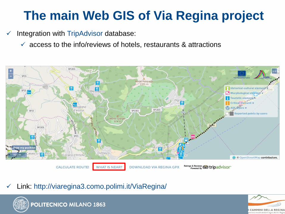
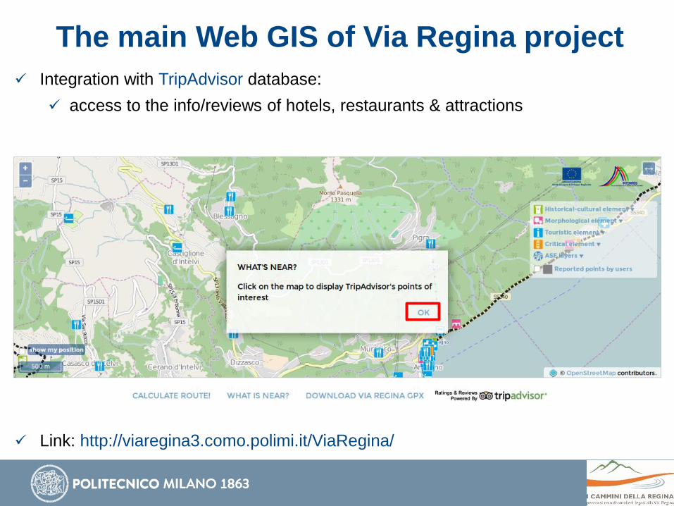
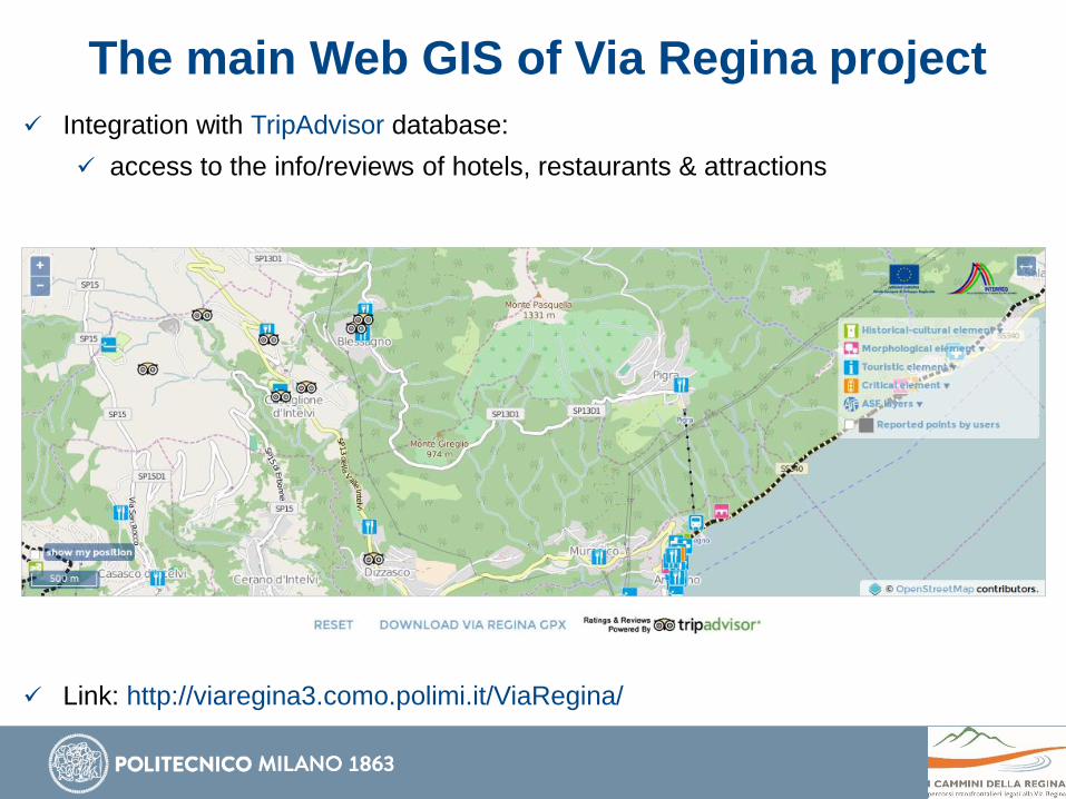
The main Web GIS of Via Regina project
Integration with TripAdvisor database:
access to the info/reviews of hotels, restaurants & attractions
Link: http://viaregina3.como.polimi.it/ViaRegina/
The main Web GIS of Via Regina project
Integration with TripAdvisor database:
access to the info/reviews of hotels, restaurants & attractions
Link: http://viaregina3.como.polimi.it/ViaRegina/
The main Web GIS of Via Regina project
Integration with TripAdvisor database:
access to the info/reviews of hotels, restaurants & attractions
Link: http://viaregina3.como.polimi.it/ViaRegina/

The main Web GIS of Via Regina project
Integration with TripAdvisor database:
access to the info/reviews of hotels, restaurants & attractions
Link: http://viaregina3.como.polimi.it/ViaRegina/
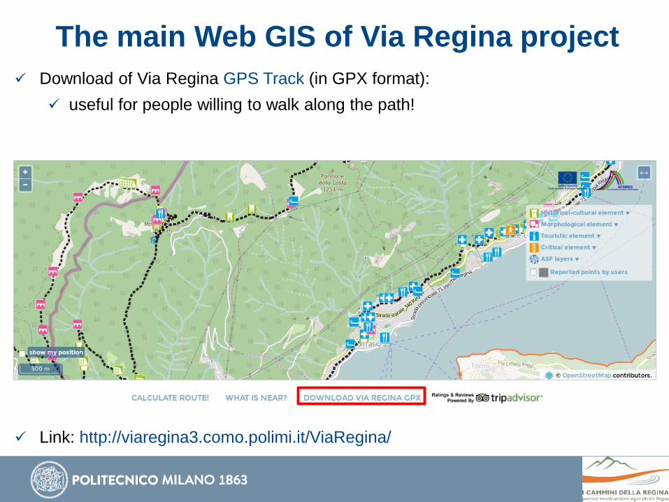
The main Web GIS of Via Regina project
Download of Via Regina GPS Track (in GPX format):
useful for people willing to walk along the path!
Link: http://viaregina3.como.polimi.it/ViaRegina/
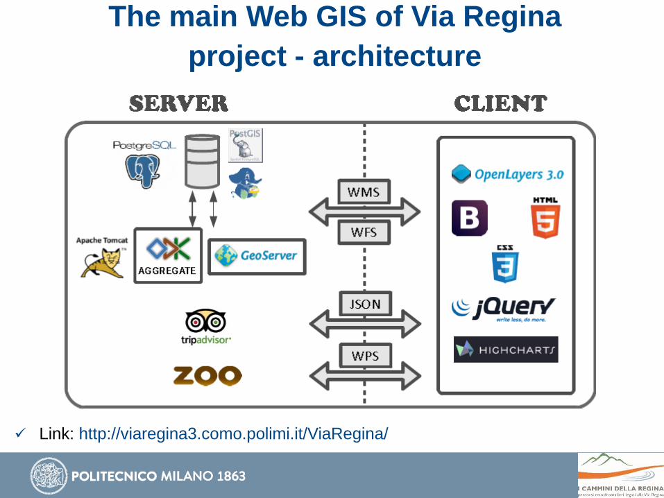
The main Web GIS of Via Regina
project - architecture
Link: http://viaregina3.como.polimi.it/ViaRegina/

Cross-platform VGI application - purpose
Allows everyone to report georeferenced points of interest:
historical and cultural elements
morphological elements
tourism elements
critical elements

Cross-platform VGI application - purpose
Historical and Cultural Elements
museum
religious building
civil building
archeological element
rural building
military building
factory
Morphological Elements
surface
bounding escarpment
traffic support and manufactured products
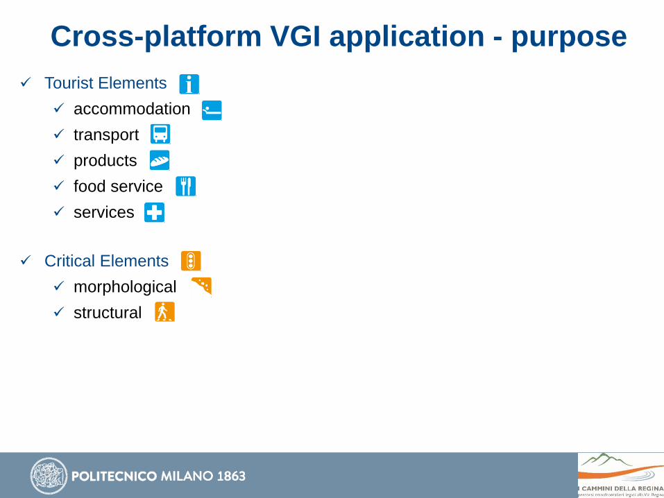
Cross-platform VGI application - purpose
Tourist Elements
accommodation
transport
products
food service
services
Critical Elements
morphological
structural
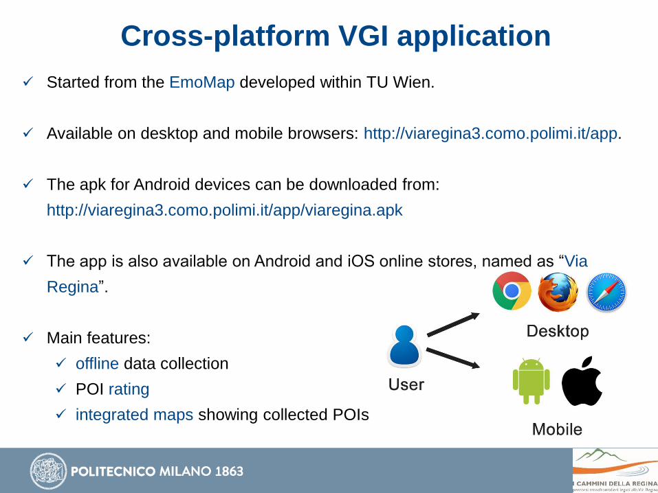
Cross-platform VGI application
Started from the EmoMap developed within TU Wien.
Available on desktop and mobile browsers: http://viaregina3.como.polimi.it/app.
The apk for Android devices can be downloaded from:
http://viaregina3.como.polimi.it/app/viaregina.apk
The app is also available on Android and iOS online stores, named as “Via
Regina”.
Main features:
offline data collection
POI rating
integrated maps showing collected POIs
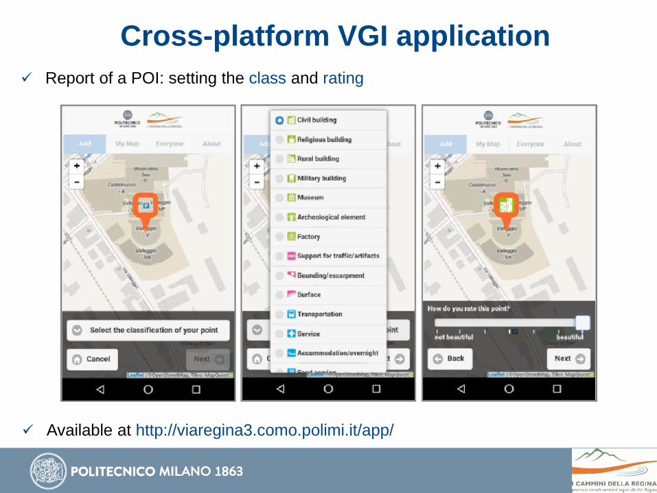
Cross-platform VGI application
Report of a POI: setting the class and rating
Available at http://viaregina3.como.polimi.it/app/

Cross-platform VGI application
Report of a POI: take/upload a picture of it
Available at http://viaregina3.como.polimi.it/app/
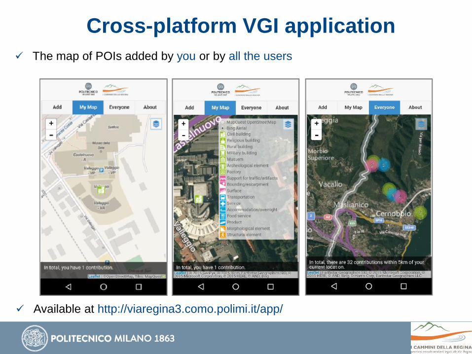
Cross-platform VGI application
The map of POIs added by you or by all the users
Available at http://viaregina3.como.polimi.it/app/

Cross-platform VGI application
Query of a POI and the app info
Available at http://viaregina3.como.polimi.it/app/
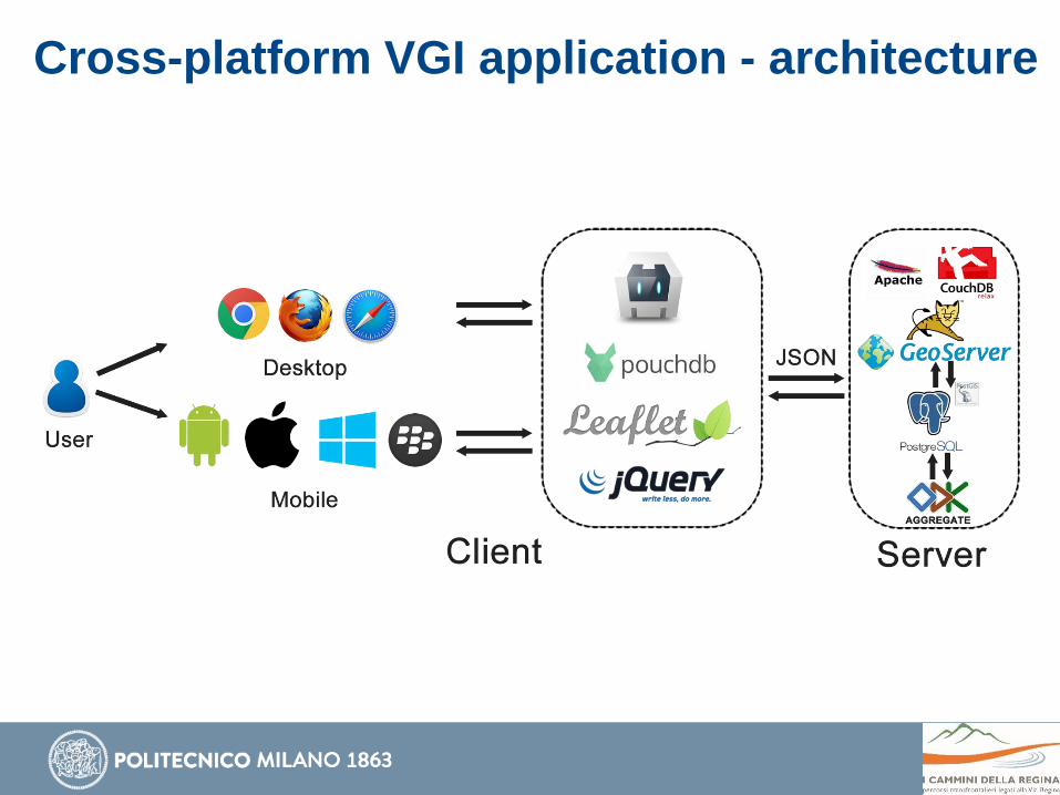
Cross-platform VGI application - architecture

ODK (Open Data Kit)
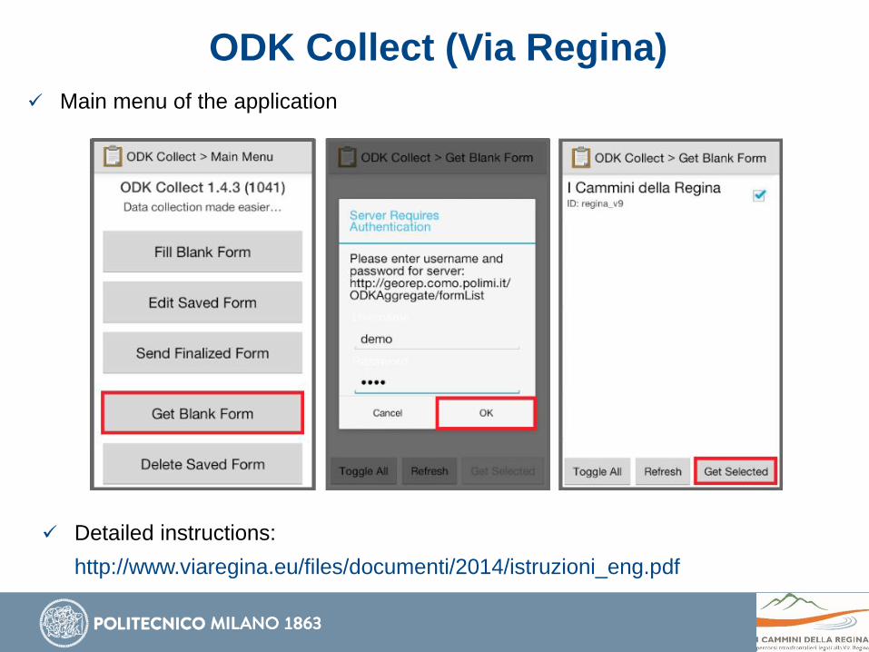
ODK Collect (Via Regina)
Main menu of the application
Detailed instructions:
http://www.viaregina.eu/files/documenti/2014/istruzioni_eng.pdf
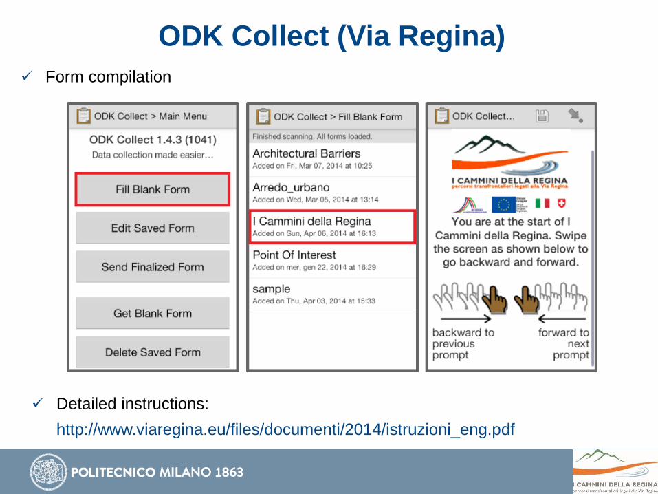
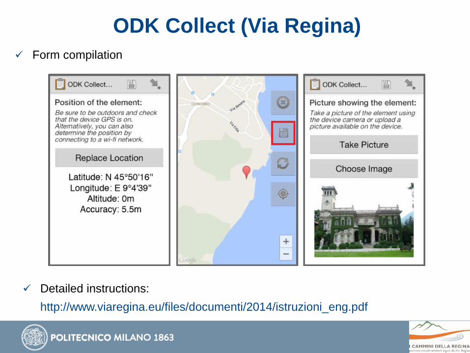
ODK Collect (Via Regina)
Form compilation
Detailed instructions:
http://www.viaregina.eu/files/documenti/2014/istruzioni_eng.pdf
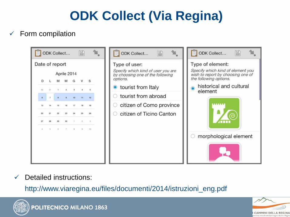
ODK Collect (Via Regina)
Form compilation
Detailed instructions:
http://www.viaregina.eu/files/documenti/2014/istruzioni_eng.pdf
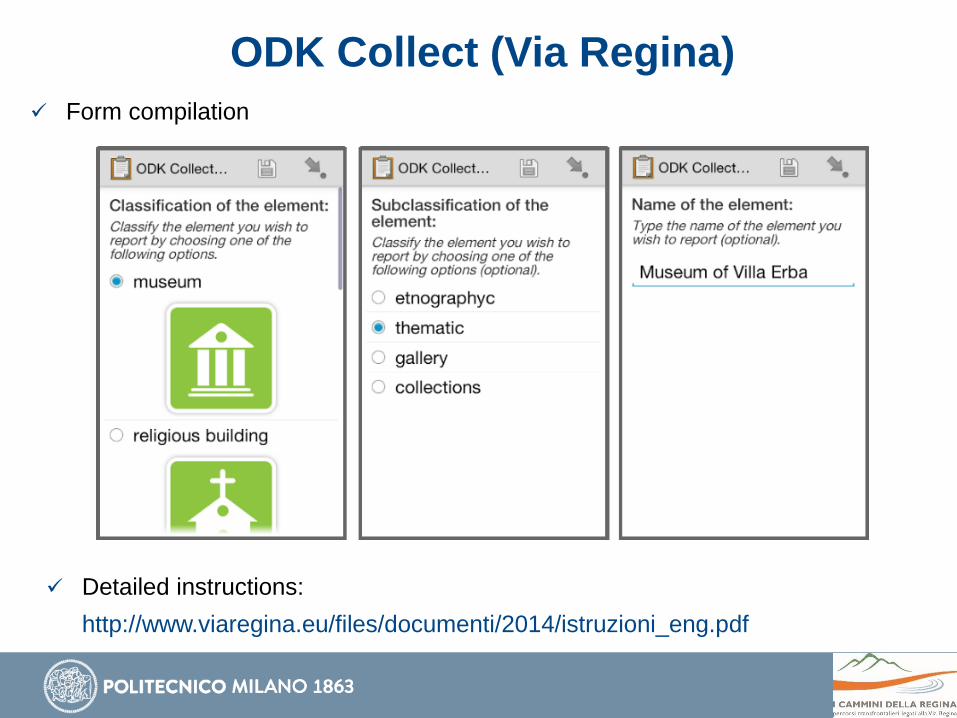
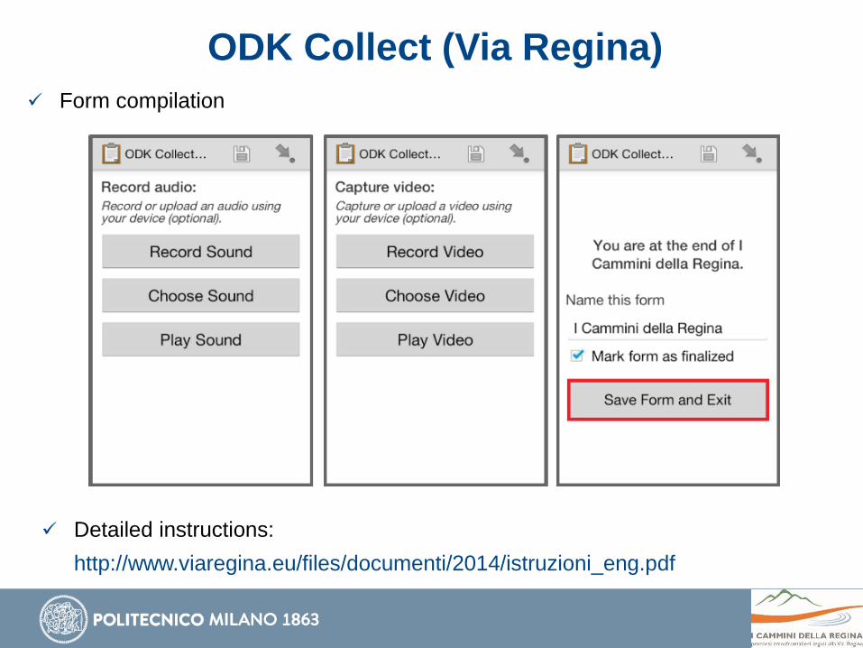
ODK Collect (Via Regina)
Form compilation
Detailed instructions:
http://www.viaregina.eu/files/documenti/2014/istruzioni_eng.pdf
ODK Collect (Via Regina)
Form compilation
Detailed instructions:
http://www.viaregina.eu/files/documenti/2014/istruzioni_eng.pdf
ODK Collect (Via Regina)
Form compilation
Detailed instructions:
http://www.viaregina.eu/files/documenti/2014/istruzioni_eng.pdf
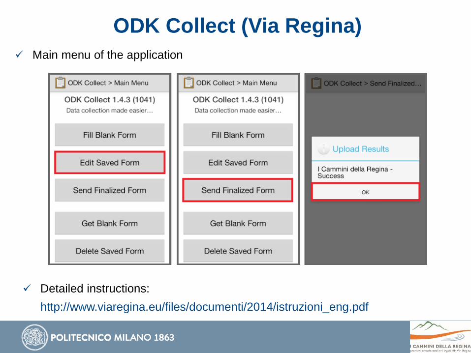
ODK Collect (Via Regina)
Main menu of the application
Detailed instructions:
http://www.viaregina.eu/files/documenti/2014/istruzioni_eng.pdf
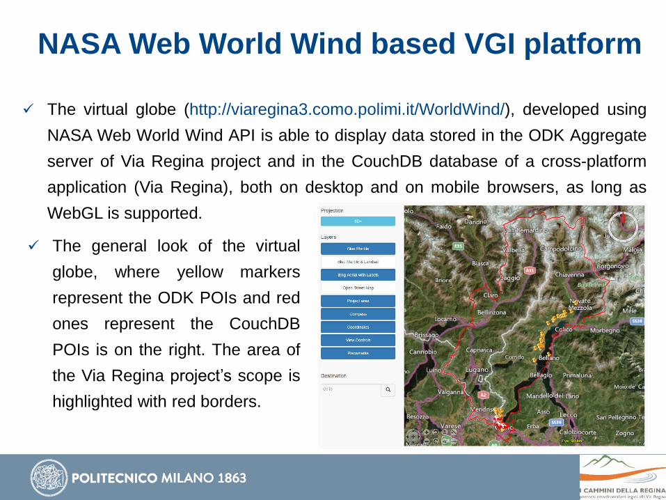
NASA Web World Wind based VGI platform
The virtual globe (http://viaregina3.como.polimi.it/WorldWind/), developed using
NASA Web World Wind API is able to display data stored in the ODK Aggregate
server of Via Regina project and in the CouchDB database of a cross-platform
application (Via Regina), both on desktop and on mobile browsers, as long as
WebGL is supported.
The general look of the virtual
globe, where yellow markers
represent the ODK POIs and red
ones represent the CouchDB
POIs is on the right. The area of
the Via Regina project’s scope is
highlighted with red borders.
Available at http://viaregina3.como.polimi.it/WorldWind/
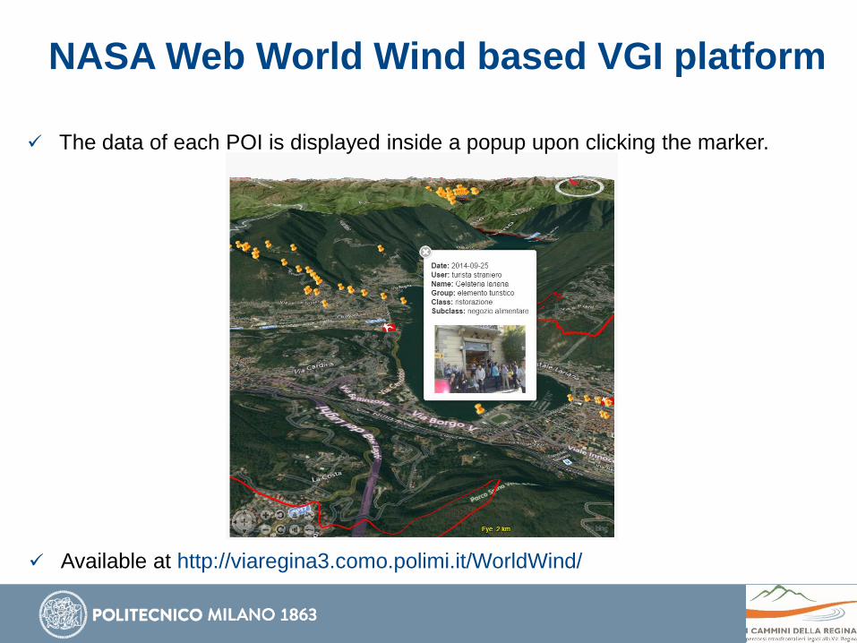
The data of each POI is displayed inside a popup upon clicking the marker.
NASA Web World Wind based VGI platform
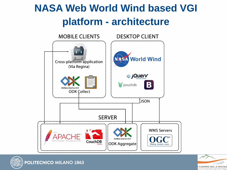
NASA Web World Wind based VGI
platform - architecture
PoliCrowd 2.0
Collecting, managing, visualizing data in 3D/4D.
The volunteered data is submitted through Android mobile devices, using
ODK Collect application.
The data is visualized on a NASA World Wind Java SDK based virtual
globe.
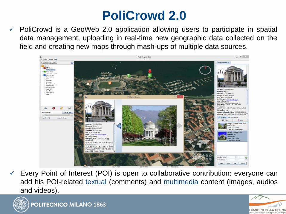
PoliCrowd 2.0 PoliCrowd is a GeoWeb 2.0 application allowing users to participate in spatial
data management, uploading in real-time new geographic data collected on the
field and creating new maps through mash-ups of multiple data sources.
Every Point of Interest (POI) is open to collaborative contribution: everyone can
add his POI-related textual (comments) and multimedia content (images, audios
and videos).
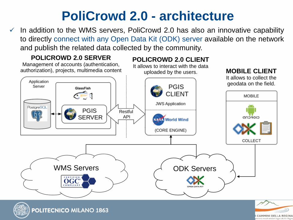
PoliCrowd 2.0 - architecture In addition to the WMS servers, PoliCrowd 2.0 has also an innovative capability
to directly connect with any Open Data Kit (ODK) server available on the network
and publish the related data collected by the community.
WMS Servers ODK Servers
Restful
API
Application
Server
MOBILE CLIENTIt allows to collect the geodata on the field.
POLICROWD 2.0 CLIENTIt allows to interact with the data
uploaded by the users.
POLICROWD 2.0 SERVERManagement of accounts (authentication,
authorization), projects, multimedia content
Thanks for your attention!