Embed Size (px)
Citation preview

Open Geospatial Consortium
(OGC)
Open Standards
September 2015
Rafael MorenoDepartment of Geography and Environmental Sciences

There are many dimensions to “Open”
• Open source software.
• Open data.
• Open specifications/standards.
• Open publishing.
• Open education resources.
• Open government.
• Open innovation.
?

FOSS/FOSS4GOpen
Standards
?
http://www.sutor.com/c/essays/osvsos/http://oss-watch.ac.uk/resources/openstandardsopensource
Why “Open”?
Open Data Handbook: Why Open Data?http://opendatahandbook.org/guide/en/why-open-data/
Why FOSS? http://www.dwheeler.com/oss_fs_why.html
Why open access? http://www.sparc.arl.org/resources/open-access/why-oa
Why open education mattershttp://whyopenedmatters.org/
Why open government mattershttps://www.whitehouse.gov/blog/2009/12/09/why-open-government-matters

OGC Open Standards for Geospatial Information

“Open standards” means that the standards documents are:
• Freely and publicly available
• Non discriminatory
• Free of license fees
• Vendor neutral
• Data neutral
• Agreed to by a formal, member based consensus process
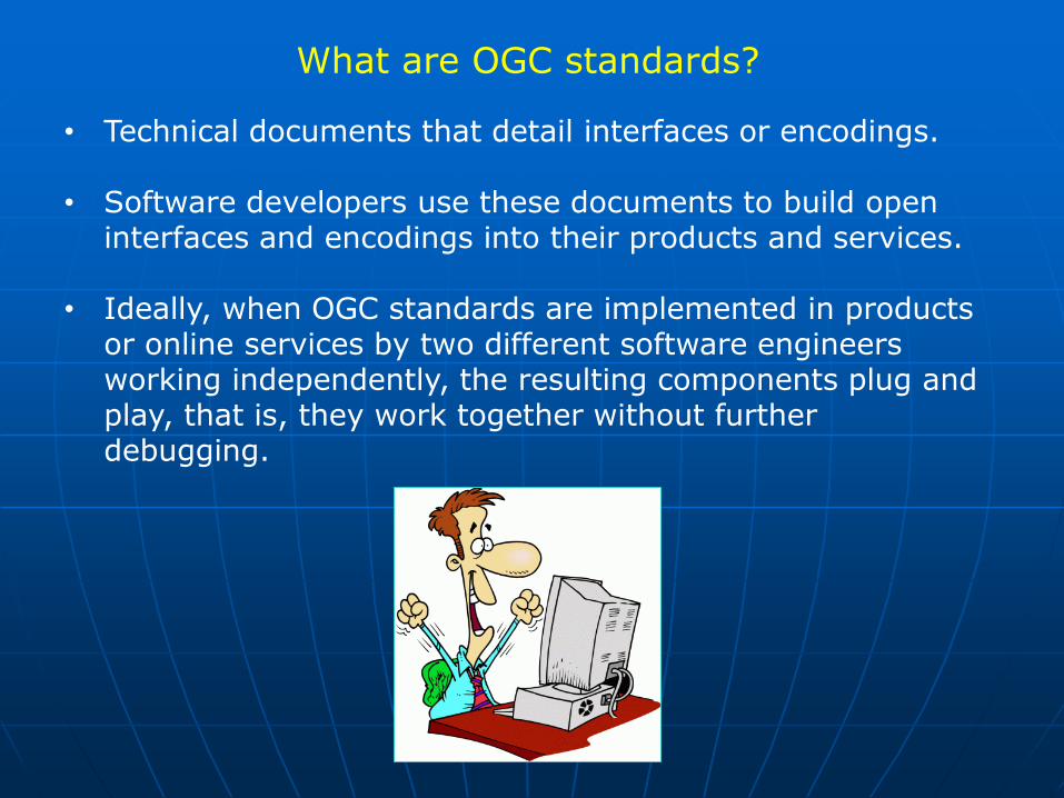
What are OGC standards?
• Technical documents that detail interfaces or encodings.
• Software developers use these documents to build open interfaces and encodings into their products and services.
• Ideally, when OGC standards are implemented in products or online services by two different software engineers working independently, the resulting components plug and play, that is, they work together without further debugging.


Why Geospatial Open Standards?Benefits of Interoperability
• Avoid over-dependence on a single vendor.
• Broadened product acquisition opportunities: Mix and match components.
• Minimize risks as technology change.
• Leverage legacy investments.
• Maximize access to outside information resources.
• Maximize outside access to your information resources.
• Ready access to data; data integration.
• Work more quickly and cheaply.
• Higher return on investment.

• Easier access to multiple online info and data sources and services.
• Use and reuse different vendor solutions.
• Reduce deployment costs by reusing information from other communities.
• Rapidly mobilize new capabilities (plug and play).
• Meet requirements for citizen access.
• Foundation for interoperable service networks.
• Standards reduce risk and costs.
Create a common picture of reality
Why Geospatial Open Standards?Benefits of Interoperability ….

The need
Integration
Interoperability
Collaboration
Transparency
A common picture

OGC Geospatial Fusion Pilot Project
http://www.opengeospatial.org/projects/initiatives/gfspphttps://www.ise.gov/blog/ise-bloggers/inter-agency-geospatial-collaboration-work
Fusion of Geospatial Information
Making data discoverable and accessible through one spatial framework

http://www.earthmagazine.org/article/digitizing-earth-developing-cyberinfrastructure-geoscienceshttp://semanticommunity.info/Data_Science/EarthCube_Data_Science_Publications
Cyberinfrastructure for the Geosciences

Earth Observation System of Systems

Source: Luiz Bermudez http://www.inegi.org.mx/RDE/RDE_05/RDE_05_Art6.html
National and Global Spatial Data Infrastructures

OGC Implementation Standards
They are written for a more technical audience and detail the interface structure between software components.
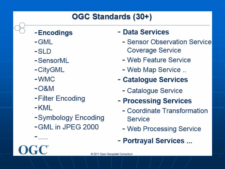
More than 30 baseline standardshttp://www.opengeospatial.org/docs/ishttps://en.wikipedia.org/wiki/Open_Geospatial_Consortium#Standards
GML 3.0 alone is 529 pages.

OGC Implementation Standards
Approximately 70September 2015
http://www.opengeospatial.org/docs/ishttp://www.opengeospatial.org/standards/specifications/list

What is the difference between and specification and a standard?
A standard is a specification, but a specification is not necessarily a standard.
• Specifications are documents that describe protocols, data encodings, software interfaces and other aspects of information and process sharing.
• A standard is a specification that developers in numerous companies can use to ensure that their products "work together.“the authority of a standard derives from the breadth of its acceptance in the marketplace and the authority of the standard setting organization sponsoring it.
• Every software company develops specifications to guide development of their proprietary technologies.
• OpenGIS® Specifications, on the other hand, are "consensus standards" similar to HTML, XML, TCP/IP and the other standards that define the Internet and the Web. http://www.opengeospatial.org/ogc/faq/abstractspec#2

Jungle of Acronyms?

Resources to Explore and Learn about OGC Open Standards
OpenGeospatial e-Learning(https://github.com/opengeospatial/e-learning/wiki)
“The Goal of the OGC E-Learning program is to coordinate and provide educational materials that can support adoption of OGC standards and professional (skills) assessment”.
OGC White Papershttp://www.opengeospatial.org/pressroom/papers
Getting started with OGC standards for geospatial sharinghttp://www.eclipse.org/community/eclipse_newsletter/2014/march/article1.php; http://live.osgeo.org/en/standards/standards.html
Communities of interest driving interoperability(https://www.fgdc.gov/ngac/meetings/april-2012/open-geospatial-consortium-activities-reichardt.pdf)
Open Web Mapping course onlinehttps://www.e-education.psu.edu/geog585/

Resources to Explore and Learn about OGC Open Standards
OGC Reference Modelhttp://www.opengeospatial.org/standards/orm
OGC Reference Architecture Profile (RAP) AdvisorRecommendations for system development.http://rap.opengeospatial.org/
OGC Best Practices documentshttp://www.opengeospatial.org/docs/bp

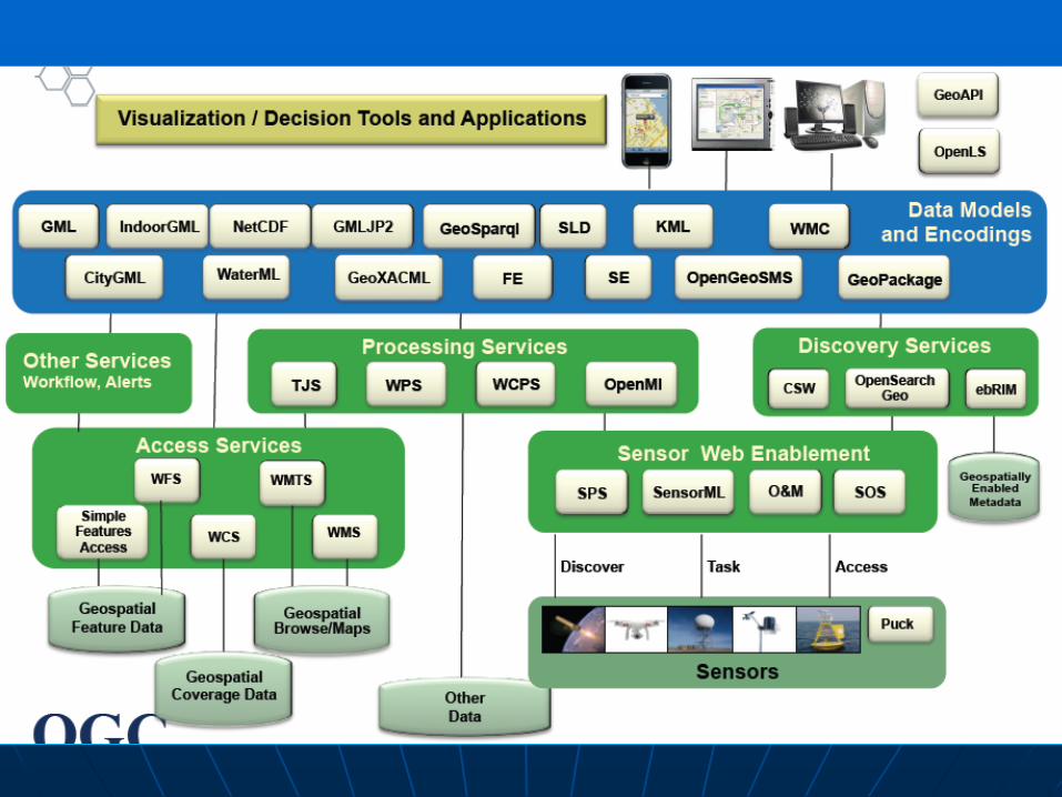
Types of OGC Standards
Encoding standards:Rules that determine how to organize information, typically sent by a service provider or produced by an application. GeoPackage GML 3.2 SensorML waterML CityGML IndoorGML
Interface standards:Rules that determine the operations between service providers and service requesters. For example, an interface to request maps to a map service provider.WMS, WFS, WCS
https://github.com/opengeospatial/e-learning/wiki

Geospatial Web services using OGC standards
It helps to think of publish, find and bind as the key functions for applications in a Web services environment (SOA Services Oriented Architecture).
Dataor
Service
Catalogueor
GeoPortal

OGC Web Services OWS

Data Delivery Services
• WMS (Web Map Service): Generates maps as images. Response: Geo-registered JPG, PNG, etc.. Raster
• WFS (Web Feature Service): Generates geographic entities or features. Vector
• Response: Features usually in GML format.
• WFS-T (WFS-Transactions): Allows creation, deletion and updating of features. Vector
• WCS (Web Coverage Service): Generates geospatial coverages representing space-varying phenomena Grid
• SOS (Sensor Observation Service): API for managing measured data as well as metadata from heterogenoussensors Data XML

WMS

Web Map
Server
Web Coverage
ServerWeb Feature
Server

Sensor Web Enablement (SWE) Standards
• sensorML
• Sensor Observation Service (SOS)
• Sensor Planning Service (SPS)
• Sensor Alert Service (SAS)
• Catalogue Service/Sensors

CSW Catalogue Service for the Web
Tool that supports the ability to publish and search collections of descriptive information (metadata) for data, services, and related information objects.

WPS Web Processing Service
A WPS can be configured to offer GIS functionality to clients across a network access to pre-programmed calculations and/or computation models that operate on spatially referenced data.
It provides rules for standardizing how inputs and outputs (requests and responses) for invoking geospatial processing services, such as polygon overlay, as a Web service.


Encoding Standardsstoring and transferring data
• GeoPackage
• GML 3.2 CityGML IndoorGML
• sensorML
• waterML
• KML
• Open GeoSMS
• GeoSPARQL
• Moving Features
• Symbology encoding

FOSS4G to Implement an OGC Web Services Architecture