Embed Size (px)
Citation preview
Cenozoic Geodynamic Evolution of the Burma-Andaman Platelet*
Claude Rangin1
Search and Discovery Article #30258 (2012) **
Posted December 31, 2012
*Adapted from oral presentation at AAPG International Conference and Exhibition, Singapore, 16-19 September, 2012 **AAPG©2012 Serial rights given by author. For all other rights contact author directly.
1EGERIE, National Center for Scientific Research (CNRS), University of Nice Sophia Antipolis, France ([email protected])
Abstract
The Burma-Andaman platelet is a complex shear zone extending from the northern tip of Sumatra to the Assam belt developed during the Cenozoic along the India-Sundaland plate boundary. Into the west, the India sub-continent attached to the rigid and undeformed Bengal oceanic basin and plateau is brushing the western margin of Sundaland. Two GPS networks were measured both in central and northern Myanmar and have revealed the main Sagaing-Shan fault has a constant, instantaneous strain rate (1,8 cm/yr) in both areas. This fault absorbs half of the estimated active motion between India and Sundaland (3.5 cm/yr). The Andaman sea-spreading center and the connected Sagaing-Shan fault in the north, and the the Semangko fault in Sumatra, has absorbed the same rate of motion (2 cm/yr) since the early Pliocene. Retained motion was localized along subsidiary right-lateral faults present within the Indo-Burma wedge, but also southwards along the East Andaman fault. The central Myanmar basins, filled with up to 10 km of dominantly clastic sediments deposited from the Eocene to the late Miocene, have en echelon right pull-apart basin pattern, inverted during the last 10 my. The Indo-Burma Ranges and their southern extension along the Andaman Nicobar islands and northern Sumatra reveal obliquely accreted volcanic ridges (~90°E) associated with exotic continental terranes (Kampetlet Schist, Triassic Chin Flysch), all of which drifted from Antarctica during the northern motion of India. The Yadana gas field is located on one of these scalped and partially accreted ridges topped by Cenozoic neritic carbonates transferred to the accretionary wedge. Along the eastern flank of the Indo-Burma wedge, mélanges, containing blue schist and Lower Cretaceous ophiolite, outline the wedge of the Tethys Mesozoic subduction zone, extending north of great India This Kabaw suture zone is disconformably sealed by Maastrichtian clastics, the basal formation of overlying Central Myanmar basins. In northern Burma the Eastern Tibet Plateau crustal flow has affected the northern motion of the platelet since 10 Ma, inducing large gravity sliding in the northern Bengal basin. This evolution of the Burma-Andaman platelet illustrates the complexity of a hyper-oblique convergent zone, present along the 2200-km-long India Sundaland plate boundary. This work was conducted in cooperation with Myanmar universities and Myanmar Oil and Gas Enterprise, sponsored by Total.

References
Maurin, T., and C. Rangin, 2009, Structure and kinematics of the Indo-Burmese Wedge: Recent and fast growth of the outer wedge: Tectonics, v. 28/2, 21 p. doi.org/10.1029/2008TC0022876 Nielsen, R.K., and J.R. Hopper, 2004, From rift to drift; mantel melting during continental breakup: Geochemistry Geophysics Geosystems G super 3, AGU and Geochemical Society U.S., p. 24.
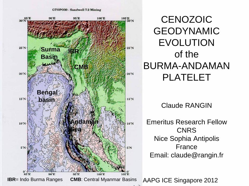
CENOZOIC
GEODYNAMIC
EVOLUTION
of the
BURMA-ANDAMAN
PLATELET
Claude RANGIN
Emeritus Research Fellow
CNRS
Nice Sophia Antipolis
France
Email: [email protected]
AAPG ICE Singapore 2012
Bengal
basin
Surma
Basin
CMB
IBR
IBR= Indo Burma Ranges CMB: Central Myanmar Basins
Andaman
Sea
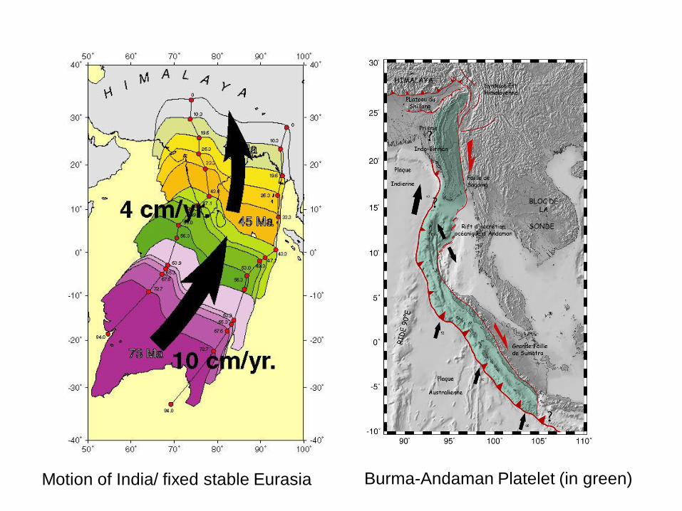
Motion of India/ fixed stable Eurasia Burma-Andaman Platelet (in green)
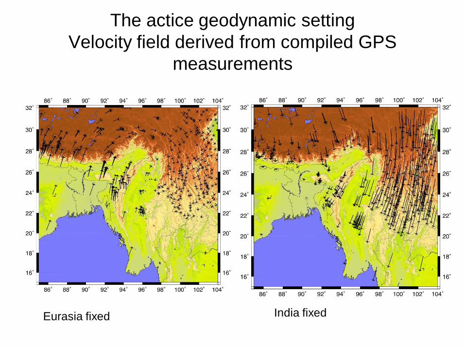
The actice geodynamic setting
Velocity field derived from compiled GPS
measurements
Eurasia fixed India fixed
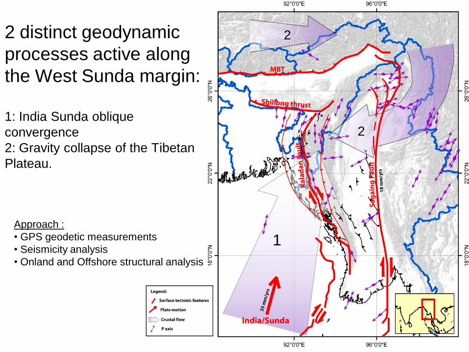
2 distinct geodynamic
processes active along
the West Sunda margin:
1: India Sunda oblique
convergence
2: Gravity collapse of the Tibetan
Plateau.
Approach :
• GPS geodetic measurements
• Seismicity analysis
• Onland and Offshore structural analysis
1
2
2
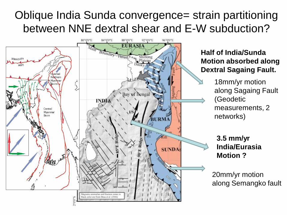
Oblique India Sunda convergence= strain partitioning
between NNE dextral shear and E-W subduction?
18mm/yr motion
along Sagaing Fault
(Geodetic
measurements, 2
networks)
20mm/yr motion
along Semangko fault
Half of India/Sunda
Motion absorbed along
Dextral Sagaing Fault.
3.5 mm/yr
India/Eurasia
Motion ?
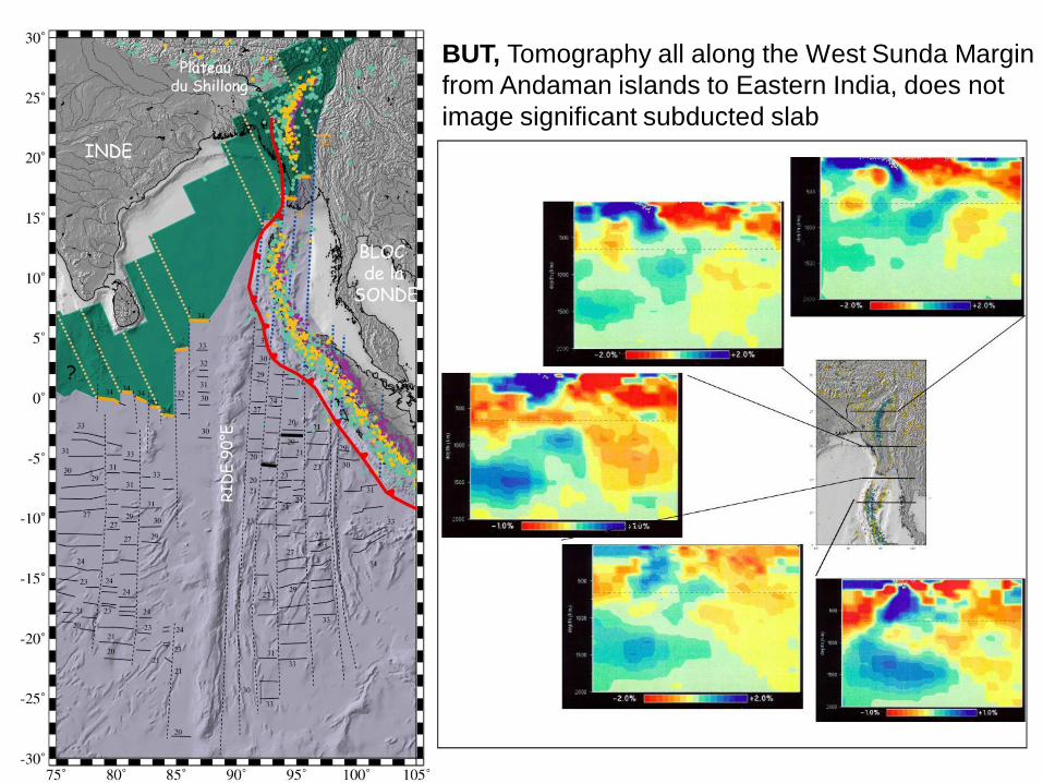
BUT, Tomography all along the West Sunda Margin
from Andaman islands to Eastern India, does not
image significant subducted slab
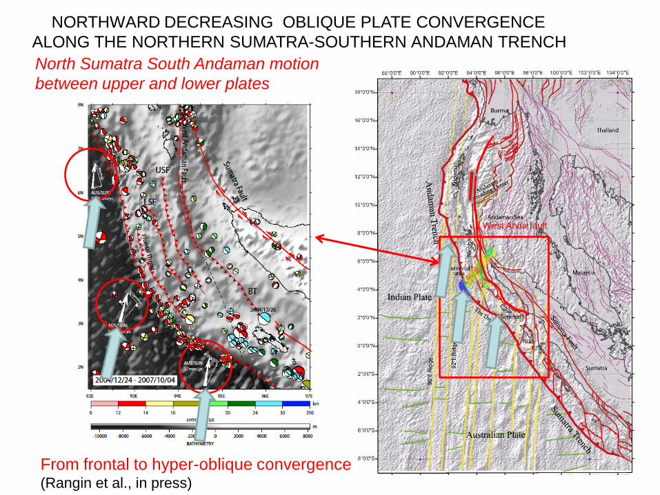
NORTHWARD DECREASING OBLIQUE PLATE CONVERGENCE
ALONG THE NORTHERN SUMATRA-SOUTHERN ANDAMAN TRENCH
From frontal to hyper-oblique convergence(Rangin et al., in press)
North Sumatra South Andaman motion
between upper and lower plates
West Anda fault
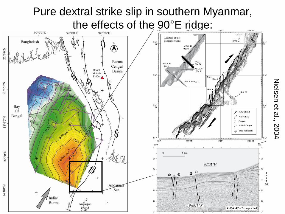
Pure dextral strike slip in southern Myanmar,
the effects of the 90°E ridge:
Nie
lse
n e
t al., 2
00
4
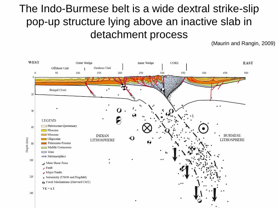
The Indo-Burmese belt is a wide dextral strike-slip
pop-up structure lying above an inactive slab in
detachment process (Maurin and Rangin, 2009)
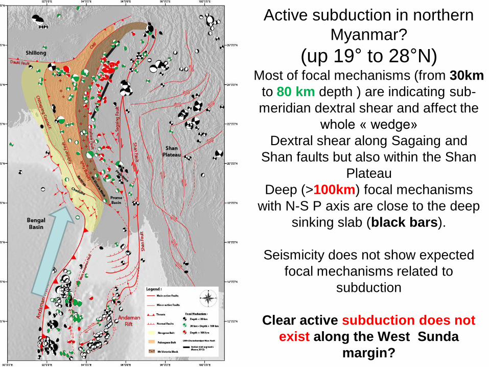
Active subduction in northern
Myanmar?
(up 19° to 28°N) Most of focal mechanisms (from 30km
to 80 km depth ) are indicating sub-
meridian dextral shear and affect the
whole « wedge»
Dextral shear along Sagaing and
Shan faults but also within the Shan
Plateau
Deep (>100km) focal mechanisms
with N-S P axis are close to the deep
sinking slab (black bars).
Seismicity does not show expected
focal mechanisms related to
subduction
Clear active subduction does not
exist along the West Sunda
margin?
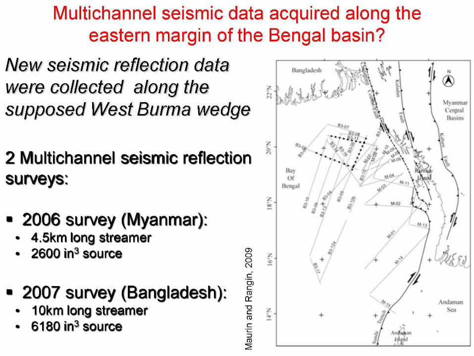
Multichannel seismic data acquired along the eastern margin of the Bengal basin?
New seismic reflection data were collected along the supposed West Burma wedge
z ~I
'" 2 Multichannel seismic reflection r.
surveys:
• 2006 survey (Myanmar): • 4.Skm long streamer • 2600 ins source (J)
/ ..
o /. o <> C'I
c OJ
• 2007 survey (Bangladesh): & • 10km long streamer ~ ~ • 6180 ins source
,
+ +
"'} nmar CcnJruI 13 lru
'.
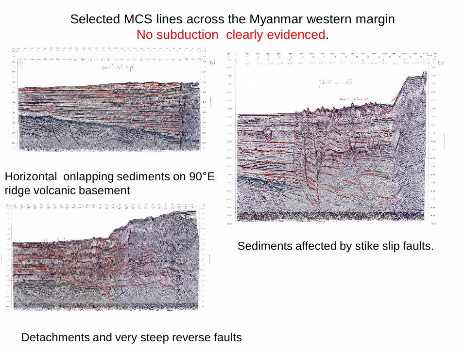
Selected MCS lines across the Myanmar western margin
No subduction clearly evidenced.
Horizontal onlapping sediments on 90°E
ridge volcanic basement
Sediments affected by stike slip faults.
Detachments and very steep reverse faults
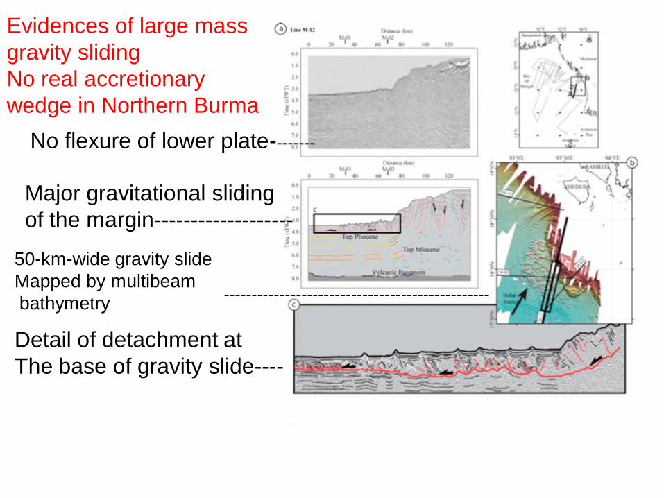
No flexure of lower plate--------
Major gravitational sliding
of the margin-------------------
Detail of detachment at
The base of gravity slide----
------------------------------------------------
50-km-wide gravity slide
Mapped by multibeam
bathymetry
Evidences of large mass
gravity sliding
No real accretionary
wedge in Northern Burma
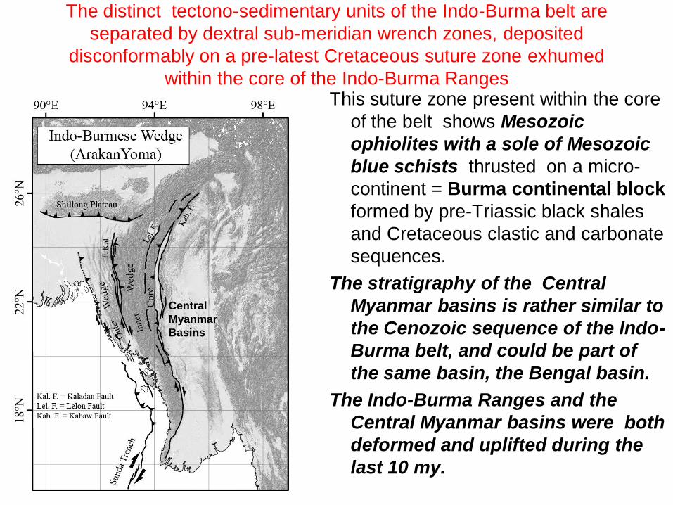
The distinct tectono-sedimentary units of the Indo-Burma belt are
separated by dextral sub-meridian wrench zones, deposited
disconformably on a pre-latest Cretaceous suture zone exhumed
within the core of the Indo-Burma RangesThis suture zone present within the core
of the belt shows Mesozoic
ophiolites with a sole of Mesozoic
blue schists thrusted on a micro-
continent = Burma continental block
formed by pre-Triassic black shales
and Cretaceous clastic and carbonate
sequences.
The stratigraphy of the Central
Myanmar basins is rather similar to
the Cenozoic sequence of the Indo-
Burma belt, and could be part of
the same basin, the Bengal basin.
The Indo-Burma Ranges and the
Central Myanmar basins were both
deformed and uplifted during the
last 10 my.
Central
Myanmar
Basins
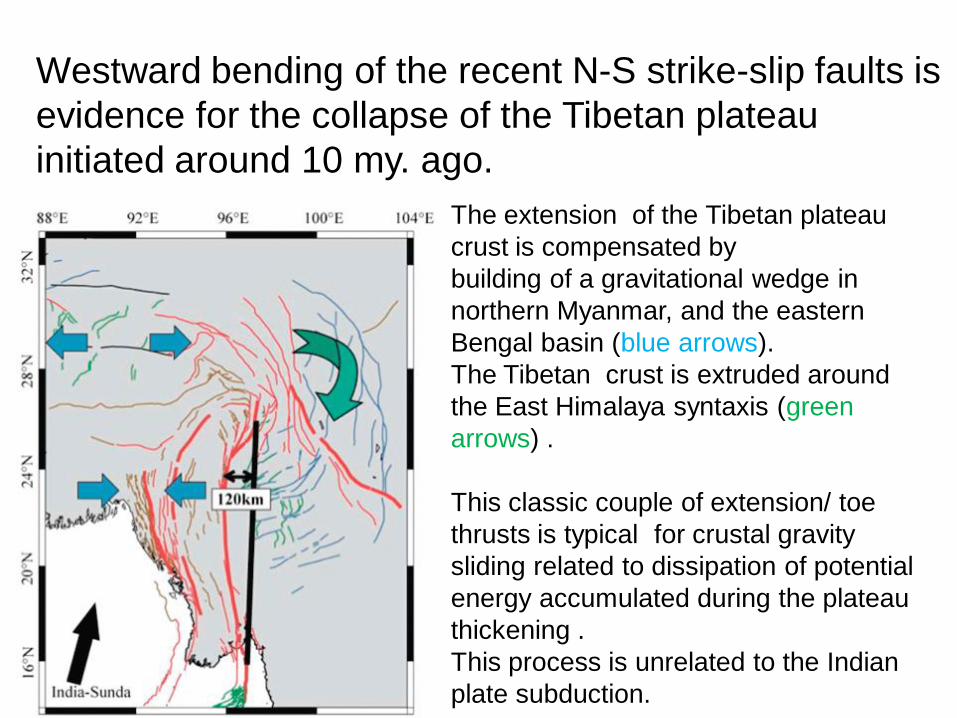
Westward bending of the recent N-S strike-slip faults is
evidence for the collapse of the Tibetan plateau
initiated around 10 my. ago.
The extension of the Tibetan plateau
crust is compensated by
building of a gravitational wedge in
northern Myanmar, and the eastern
Bengal basin (blue arrows).
The Tibetan crust is extruded around
the East Himalaya syntaxis (green
arrows) .
This classic couple of extension/ toe
thrusts is typical for crustal gravity
sliding related to dissipation of potential
energy accumulated during the plateau
thickening .
This process is unrelated to the Indian
plate subduction.

CONCLUSIONS
On the geodynamic point of view, the evolution of the Burma platelet is controlled,
since 10Ma, by two distinct forces:
1- Motion of India (and attached Bengal Basin) toward the N or the NNE
with respect to Eurasia, after collision of the Mesozoic Burma continental
block with Sundaland 70Ma to 45 Ma (Indus suture zone).
- Transtension was dominant afterwards up to 10Ma, generating important depocenters
In the Central Myanmar basins but also a main foreland basin along the future
Indo-Burma Ranges.
- Both depoceters draining most of the clastics derived from the erosion of the
India/Asia collision were inverted in the late Neogene, 10 Ma; main depocenters
migrated westward in the present Bengal basin.
2 -The late Miocene-to-present (since 10Ma) collapse of the Tibet Plateau interfered with the
sub-meridian India/Eurasia convergence. Crustal flow around the East
Himalayan Syntaxis forces the Burma platelet to protrude westward towards in the
Bengal basin. The consequence is the presence in northern Burma,
Bangladesh, and NE India of a large Neogene gravitational wedge.
Implications for oil exploration are important:
-The Indo-Burma Ranges cannot be considered any more as a classical
accretionary wedge related to oblique subduction, but as a gravitational
sedimentary mass flow probably thrusted on deep prospects present in the Bengal basin.
Thank you for your attention