Embed Size (px)
Citation preview

Santa Clara Valley Transportation
Authority
North East County Open House
Santa Clara City Hall Council
Chambers
July 21, 2014

El Camino Bus Rapid Transit Project

El Camino Real Bus Rapid Transit Project
Would upgrade the current 522 Rapid Bus to BRT status by
making changes to El Camino Real and The Alameda that
make transit FAST, FREQUENT AND RELIABLE and make
WALKING and BICYCLING along the corridor SAFER.
El Camino Real Bus Rapid Transit Project
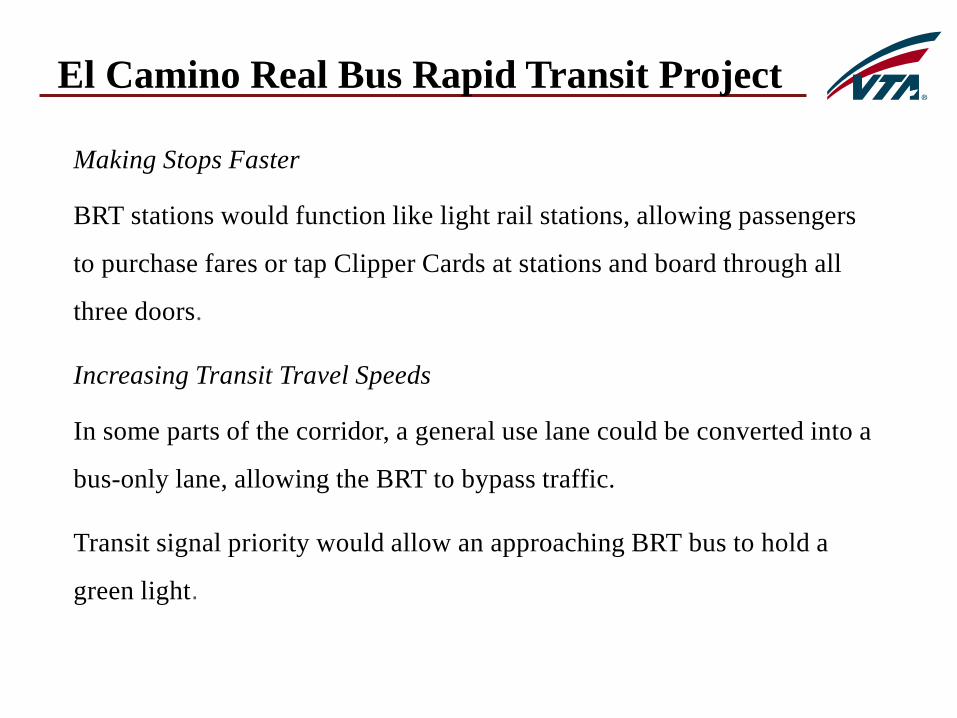
Making Stops Faster
BRT stations would function like light rail stations, allowing passengers
to purchase fares or tap Clipper Cards at stations and board through all
three doors.
Increasing Transit Travel Speeds
In some parts of the corridor, a general use lane could be converted into a
bus-only lane, allowing the BRT to bypass traffic.
Transit signal priority would allow an approaching BRT bus to hold a
green light.

El Camino Real Bus Rapid Transit Project
Making Bicycling and Walking Safer
El Camino Real is designed for cars and can be a scary and dangerous place
to bicycle or walk. Many bicycle and pedestrian collisions occur each year
and some are fatal.
In parts of the corridor with bus-only lanes, bicycle lanes could be
installed (if the city approves).
Crossing distances would be shortened and new intersections, signals and
crosswalks can be added to make El Camino Real less of a barrier between
neighborhoods.
Median BRT stations would act as pedestrian refuges.

Mixed Flow Configuration
Two Possible Ways to Implement BRT

Dedicated Lane Configuration
Two Possible Ways to Implement BRT

How Bus-Only Lanes Work – Dedicated Lanes
In some parts of the corridor, the bus-only lane would be in the center of the
street, adjacent to the median. BRT stations would be in the middle of the
street. The eastbound and westbound stations would be on opposite sides of
the intersection.
Bus-Only Lanes
WB BRT Station
El Camino Real Bus Rapid Transit Project

How Bulbout Stations Work - Mixed Flow
In parts of the corridor with bulbout stations, the curb would be
extended out to the travel lane. The BRT would stop in the
travel lane while passengers board—approximately a 20-second
duration.
BRT stops in lane
Bulbout BRT Station
El Camino Real Bus Rapid Transit Project

Project Alternatives and Environmental Analysis
Seven project alternatives—ranging from doing nothing to
building 14 miles of bus-only lanes—are currently being
studied by VTA.
A Draft Environmental Impact Report (DEIR), which
analyzes the impact that the project will have across 17
categories will be released in late Summer, 2014.
VTA’s Board of Directors will choose a locally preferred
alternative after the public comment period for the DEIR.
El Camino Real Bus Rapid Transit Project

Public Outreach and City Coordination
2010 to present Monthly meetings with city staff
Summer, 2011 City Council, committee presentations
Fall, 2011 Open House community meetings
Spring , 2012 City Council, committee presentations
Fall, 2012 VTA Board of Directors workshop, mtg.
February, 2013 Environmental Scoping meetings
El Camino Real Bus Rapid Transit Project

Silicon Valley Express Lanes

What are Express Lanes?
• Express Lanes are converted carpool lanes that
offer solo drivers the opportunity to use carpool
lanes for a fee.
13

Why are Express Lanes being developed?
• To provide congestion relief through more
effective use of HOV lane capacity
• To provide commuters with a new mobility
option
• To better manage lanes to keep traffic moving
and provide more reliable travel times
14

Who can use Express Lanes?
• SOLO DRIVERS: Can use Express Lanes for a
fee when there is available capacity.
• CARPOOL USERS: Eligible vehicles with two
or more people per car, exempt clean air vehicles,
transit buses, and motorcycles travel in Express
Lanes FREE of charge.
15

Why drivers use Express Lanes
• Drivers choose to use Express Lanes for a variety
of reasons at different times, but the most reported
reasons are:
• Time Savings
• Ease of Commute
• Convenience
16
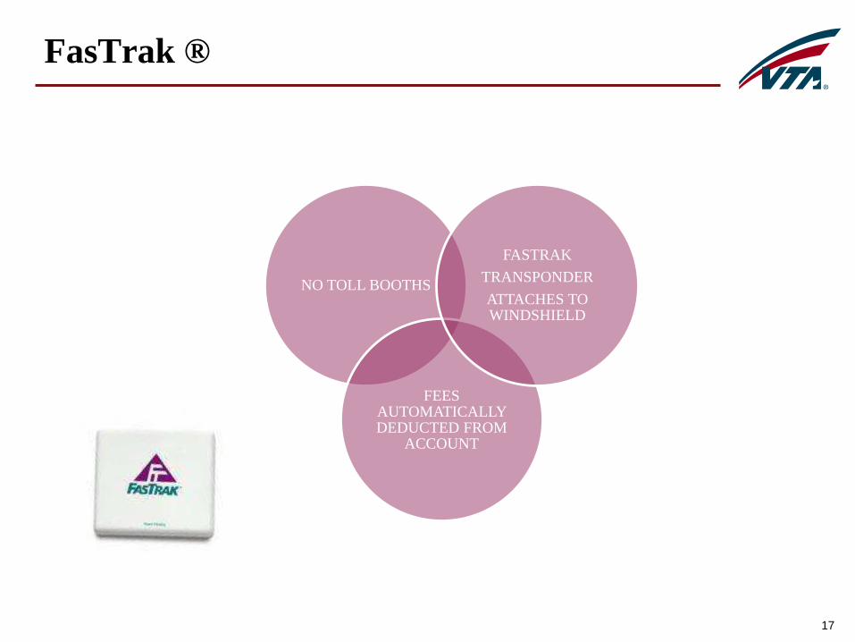
FasTrak ®
17
NO TOLL BOOTHS
FEES AUTOMATICALLY DEDUCTED FROM
ACCOUNT
FASTRAK
TRANSPONDER
ATTACHES TO WINDSHIELD

How Much Do Solo Drivers Pay?
• Range of cost on SR 237 has been
between $0.30 and $4.75, with an
average toll less than $2.00
• Pricing changes as the number of
cars increases or decreases to
ensure a free flow of traffic
• When more cars are on the
roadway, the price to enter the
Express Lanes is higher. When
there are fewer cars on the road,
the price is lower
18

Digital Signage and Pricing
19

How Do I Pay?
• Step 1: Visit bayareafastrak.org to learn about
FasTrak®
• Step 2: Purchase a toll tag through FasTrak® or at
retail locations
• Step 3: Register your new toll tag immediately to
a new or existing FasTrak® account online
or by phone at (877) 229-8655.
• Step 4: After you have completed the registration
process, mount toll tag in your vehicle and
begin enjoying the benefits of FasTrak®.
20

How Are Toll Revenues Used?
• Expenses for operations,
maintenance, and enforcement of
Express Lanes are the first use of
toll revenues.
• Any remaining revenues are to be
used within the corridor for
transportation improvements
including transit
21

Where /When Can I Use Express Lanes?
Express Lanes are proposed on the following routes:
• SR 237 Express Lanes• Phase 1 (in operation March 2012)
• Phase 2 (2016 pending funding)
• SR 85 Express Lanes - 2017 pending funding
• US 101 Express Lanes - 2017 pending funding
• Express Lanes will operate at the same times as existing HOV lanes.
22

23

SR 237 Express Lanes Data
• Up to 10,000 solo drivers use the SR 237 Express
Lanes each week
• Solo drivers have saved up to 20 minutes
• Drivers in the general purpose lanes are saving up to
seven (7) minutes
24

SR 237 Express Lanes – Phase 2
• Project Description
• Single-lane Express Lane (convert HOV lane from
existing Phase 1 terminus to approximately Mathilda
Ave.)
• Project length: 4 miles
• Environmental Clearance
• Fall 2014
• Project Opening
• Targeting 2016, funding dependent
25

26
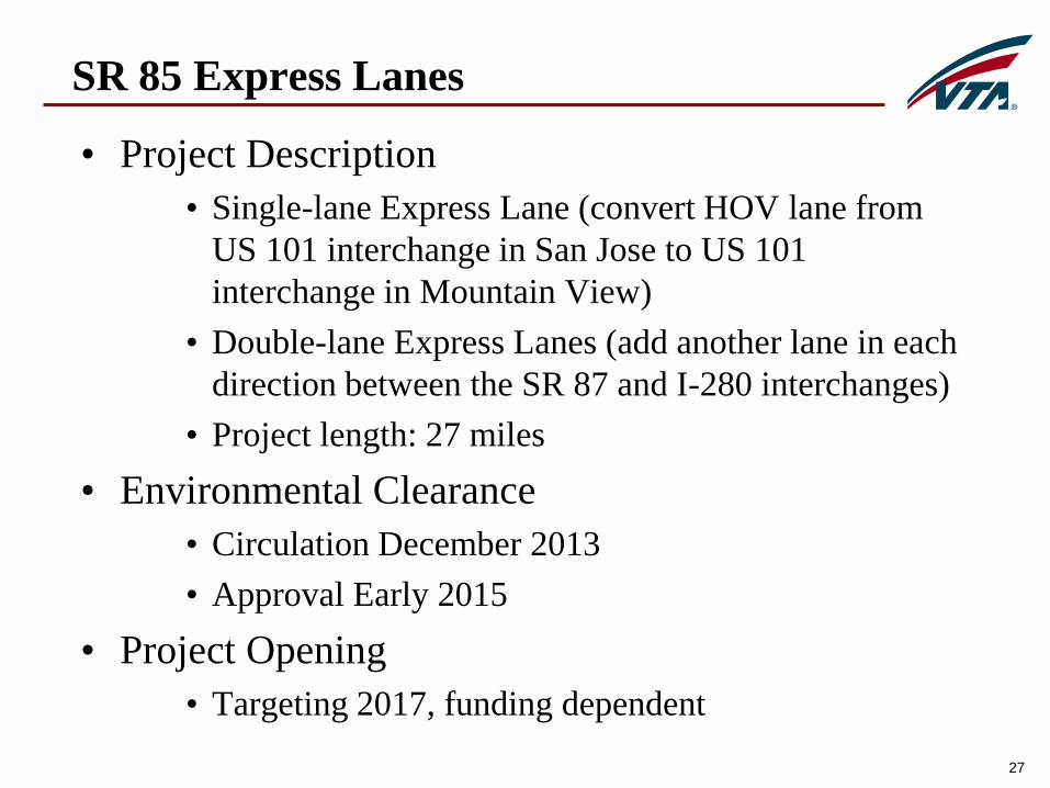
SR 85 Express Lanes
• Project Description
• Single-lane Express Lane (convert HOV lane from
US 101 interchange in San Jose to US 101
interchange in Mountain View)
• Double-lane Express Lanes (add another lane in each
direction between the SR 87 and I-280 interchanges)
• Project length: 27 miles
• Environmental Clearance
• Circulation December 2013
• Approval Early 2015
• Project Opening
• Targeting 2017, funding dependent
27

28

US 101 Express Lanes
• Project Description
• Single-lane Express Lane (convert HOV lane from Cochrane Rd. in Morgan Hill to SR 85 interchange in Mountain View)
• Double-lane Express Lanes (add a new lane between Dunne Ave. and SR 85 interchange in San Jose, between Blossom Hill Road and Mathilda Dr. in Sunnyvale; and convert double-lane HOV lanes from SR85 interchange in Mtn View to the county line in Palo Alto)
• Project length: 36 miles
• Environmental Clearance
• Early 2015
• Project Opening
• Targeting 2017, funding dependent
29

30

North Central County Bus Improvement Plan

NORTH CENTRAL COUNTY BUS IMPROVEMENT PLAN
PURPOSE
The planned Bus Rapid Transit (BRT) services on El Camino Real and Stevens Creek
may change travel demand on local bus routes that cross these corridors.
Additionally, the cities in this area (Mountain View, Sunnyvale, Santa Clara and
Cupertino) are intensifying land uses in areas that are not easily accessible by BRT so
it may be necessary to make changes to local bus service to meet a changing rider
demand. The Plan will make recommendations that will flow into VTA’s scheduled
service adjustment process.
GOALS
Improve connectivity of local routes with the BRT routes
Explore whether new service types or new routes are needed
Improve overall transit service in the study area while being cost effective
Collect input from the communities in the study area

NORTH CENTRAL COUNTY BUS IMPROVEMENT PLAN
STUDY AREA

NORTH CENTRAL COUNTY BUS IMPROVEMENT PLAN
SCHEDULE
2014
April Existing Conditions Analysis
May Development of Draft Recommendations
June Review Draft Recommendations with City Staff
July Community and City Council Meetings
August Final Recommendations released
2015
VTA’s Biennial Service Changes
2018
Service Changes relating to opening of BRT routes

Rider Surveys
New Bus Stop
Designs
Easy To Work With
TRANSIT
PASSENGER
ENVIRONMENT
PLAN
Prioritizing
Improvements
Stop Percentiles
Rid
ers
hip
Pe
rce
nta
ge
s
Most of VTA’s bus riders come from a small
percentage of stops. 21% of bus riders come
from the top 1% of bus stops. 50% of bus riders
come from 5% of bus stops.
That tells us we need to prioritize improvements
to high-ridership stops to ensure the maximum
rider benefit per dollar spent.
Prioritizing
Improvements
New Bus Stop
Designs
Easy To Work With
TRANSIT
PASSENGER
ENVIRONMENT
PLAN
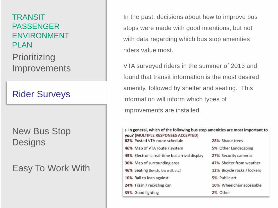
Rider Surveys
In the past, decisions about how to improve bus
stops were made with good intentions, but not
with data regarding which bus stop amenities
riders value most.
VTA surveyed riders in the summer of 2013 and
found that transit information is the most desired
amenity, followed by shelter and seating. This
information will inform which types of
improvements are installed.

Prioritizing
Improvements
Easy To Work With
TRANSIT
PASSENGER
ENVIRONMENT
PLAN
Rider Surveys
New Bus Stop
Designs
Many of VTA’s boxy, blue shelters are
approaching the end of their 20-year lifetime.
They will need to be replaced in the coming
decade so we’re looking at new, more functional,
more aesthetically pleasing shelter designs.

Prioritizing
Improvements
TRANSIT
PASSENGER
ENVIRONMENT
PLAN
Rider Surveys
New Bus Stop
Designs
Easy To Work With
In the past, VTA’s thinking about bus stop design
has been somewhat rigid and it hasn’t been easy
for cities, developers and the public to know how
to work with VTA. The Transit Passenger
Environment Plan explains all of VTA’s policies
about bus stops and makes it easy to work with
us.
Light Rail Efficiency Project
Tasman Drive Pocket Track

Project Description
• Constructs approximately 1,000 foot long storage track on Tasman Drive between Old Ironsides Drive and Patrick Henry Drive.
• Capable of storing three 3-car trains.
• Enables flexibility for VTA service to support Levi’s Stadium events in 2014 and BART connection in 2017.
• Construction Budget: Approximately $14M.• Construction Start: February 2014.• Construction End: December 2014.


Santa Clara Stadium Site
42Source: 49ers Stadium EIR, 2009/ AECOM, 2012


Light Rail Efficiency Project
Tasman Drive Pocket Track
CONSTRUCTION PHOTOS

DOUBLE CROSSOVER
INSTALLATION

TURNOUT INSTALLATION

BART Transit Integration Plan
BART Transit Integration Plan (BTIP)
• About connections to BART – but also chance to
take fresh look at service network
• Primarily focused on service and related capital
improvements (e.g., stops)
• Will address relationship of Great Mall/Main Transit
Center to Milpitas BART Station
• Fremont Express services to be addressed in advance
of others due to Warm Springs opening earlier
• Completion by mid-2015 (Warm Springs
recommendation earlier)
48

VTA Planning for BART
• BART Transit Integration Plan (BTIP) – service planning for all
BART connections and related service
• Fares and transfer policies – separate analyses
49
• Warm Springs/South Fremont
station opening 2015,
Milpitas & Berryessa 2017
• Berryessa Connector Study
(completed 2013)
recommended new trunk
services between Berryessa
and Downtown San Jose
Berryessa Connectors:
• 323 Stevens Creek every 10 min
• Downtown Limited Stop every 15 min

Service Included in Study
• Light rail service
• Santa Clara/Alum Rock Rapid & BerryessaConnector corridor (not incl. 22)
• Milpitas/BerryessaLocal
• Milpitas/BerryessaExpress & Limited Stop
• Fremont Express
50

Fremont Express Services: Initial
Findings
• Key question: Move to
new stations, eliminate,
or keep some?
• Consider ~500
boardings per day at
non-BART
stops in Fremont, higher
ridership on 181
51

BTIP Timeline
52
• Summer
• Fremont data collection
• First round of public participation
• Fall
• Alternatives development (Fremont first,
followed by rest of study area)
• Winter/Early Spring
• Alternatives Assessment – return for your input