Embed Size (px)
Citation preview

UTTARAKHAND FLOOD '13 UTTARAKHAND FLOOD '13 ::
The Himalayan Tsunami;The Himalayan Tsunami;
MAN'S OWN MAN'S OWN DOING ?DOING ?

abstractThe recent cloudburst centered on the North Indian state of Uttarakhand caused devastating floods and
landslides - the country's worst natural disaster since the 2004 Tsunami.
The subsequent natural disaster in the form of massive inundation should make many of us sit up and take notice. It is true that notwithstanding all disaster management plans, man is helpless against the vagaries of nature also borne out by regular loss of lives and property.
The tardiness of the information flow undoubtedly reflects both the exceptionally difficult terrain in this area and the magnitude of the damage. However, we can definitely be better prepared to face any such contingency for minimising the losses and damages.
The clinched but hoary dictum rightly says, “prevention is always better than cure”.

From 14 to 17 June 2013, Uttarakhand and adjoining areas received heavy rainfall, which was about 375 percent more than the benchmark rainfall during a normal monsoon. This caused the melting of Chorabari Glacier at the height of 3800 metres, and eruption of three rivers Yamuna, and Ganga and its tributaries which led to heavy floods.
brief

Though some parts of Himachal Pradesh, Haryana, Delhi and Uttar Pradesh in India, some regions of Western Nepal, and some parts of Western Tibet also experienced heavy rainfall, over 95% of the casualties occurred in Uttarakhand.
As of 16 July 2013, according to figures provided by the Uttarakhand government, more than 5,700 people were "presumed dead" after more than a month of search. This total included 934 local residents, and over 300 foreigners.
Destruction of bridges and roads left about 100,000 pilgrims and tourists trapped in the valleys leading to three of the four Hindu Char Dham pilgrimage sites.
Exact figures are still not known – whether dead or missing – of the locals, the pilgrims, the tourists, and the foreigners, and government officials fear that this exact number shall never be known.
The Indian Air force, the Indian Army, and paramilitary troops evacuated more than 110,000 people from the flood ravaged areas.

Environmentalists describe the death and damages as a man-made disaster, while geologists say the extent of destruction could have been lesser if strict regulations were in place for all the human activities there, and if authorities had been adequately equipped to deal with the situation .
It is not the first time that India has faced a tragedy at a religious site. With a large number of devotees spread across faiths, congregating at pilgrimage sites during peak seasons, these places become extremely vulnerable. The largest impact appears to have occurred at Kedarnath, which at this time of year (June-July) is an important pilgrimage destination.
Some blame is hence pointing towards improper, haphazard and inefficient management or mismanagement of these pilgrimage tours.


Note: Cruel pun intended

Unplanned development is destroying the ecology of the mountains.
None of the environmental laws are properly implemented in these ecologically fragile areas, and development is going unabated. Construction of roads and dams are the main reason for the plight of Himalayan ecosystem.

The mountains of Uttarakhand are fragile and new. Hence, Uttarakhand is inherently vulnerable to various kinds of disasters, such as high intensity rainfall, cloud bursts, landslides, flash floods and earthquakes. Its geology is ridden with fault lines. Climate change is increasing the frequency of extreme events. Our developmental projects need to take this reality into account.However, no credible environmental, or social impact assessment (EIA) for a single project has been done — a fact that even our former environment minister has accepted. We do not have a credible public consultation process; local people do not even get the EIA in their language.


Forest encroachmentThe forest cover in Uttarakhand in
1970 was 84.9%. This got reduced to 75.4% in 2000.
A total forest area of 5391.17 Ha or 13,321.83 Acres were diverted for Hydel projects. An year wise analysis shows that after the year 1987, when maximum diversion of forest had been done due to Tehri Dam, year 2002 has witnessed largest forest diversion, but the first 6 months of 2013 has witnessed the third largest forest diversion for hydel projects in Uttarakhand till date.

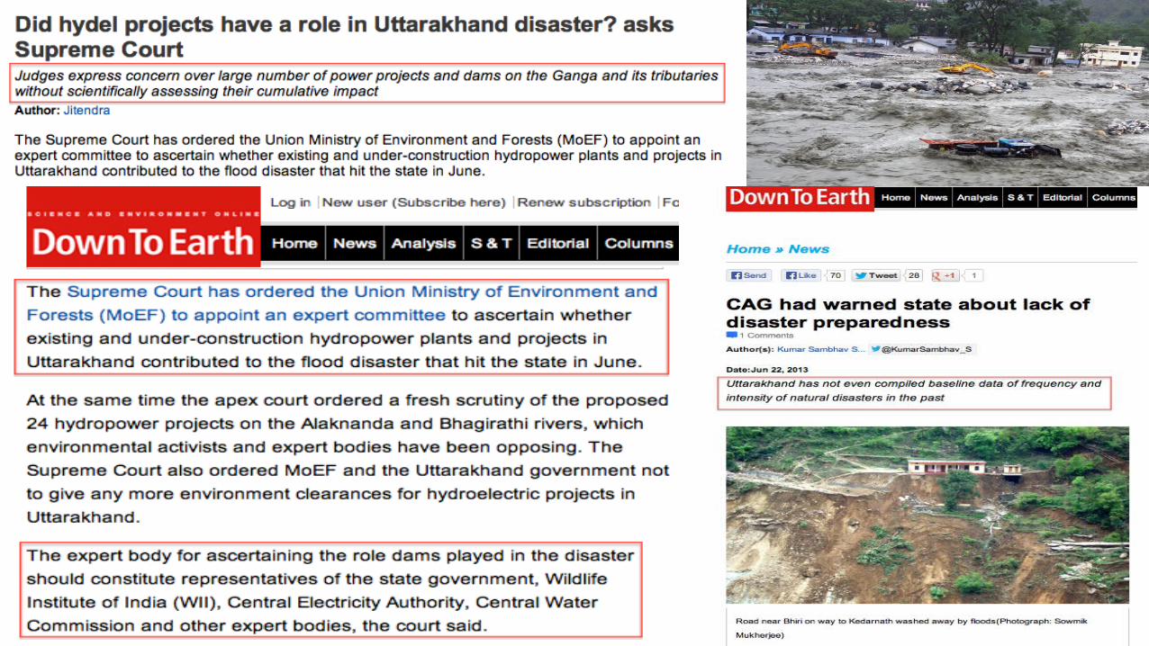
Rapid increase in the number of hydroelectricity dams in these fragile areas have led to the disruption of water balance. More than 220 power and mining projects in 14 river valleys have been carried out. Construction is carried out without the necessary precautions to minimize the risks of landslides.

Dams or Destruction ?
A total of 427 dams are planned to be built on this river system;
-roughly 70 projects built or proposed on the Ganga, all to generate some 10,000 MW of power (which will affect 80% of the Bhagirathi and 65% of the Alaknanda.)
For one dam, a stretch of 5-25 kms is being blasted through the mountains – so wide that three trains can pass simultaneously at the same time.

Hydropower projects increase the scale of disaster
Almost all hydropower projects of Uttarakhand involve deforestation. Deforestation directly increases the potential of erosion, landslides and floods since water now just runs off to the rivers.
All run of the river projects involve building of a dam, diversion structure, de-silting mechanism, as also roads, townships, mining, among other components.
Our environment compliance system is non-existing. The projects are supposed to implement the environment management plan pari passu with the project work, they are supposed to follow the conditions of environment clearance, follow the environmental norms but officials refuse to take action.

The question is not that hydropower projects should not be built at all, but is what and how much should be built. The question also is how the projects should be constructed so that impacts can be minimised.
Experts say the main indicator of the thriving real estate business in Uttarakhand is the way river beds are mined for boulders, pebbles, sand and gravel.
On June 13, 2011, Swami Nigamanand who had been fasting for 68 days in protest against the indiscriminate and illegal mining on the Ganga river bed by a local quarrying and sand mining company, died.


Tourism management
Roads – exponential increase
Data with the Uttarakhand State Transport Department confirms - In 2005-06, 4,000 vehicles were registered, which jumped to 40,000 in 2012-13.
It is an established fact that there is a straight co-relation between tourism increase and higher incidence of landslides.
The number of tourists visiting Uttarakhand since 2000 has increased by 155 per cent, according to data from the Uttarakhand Tourism department.
The annual number of tourists visiting the state now is 28 million; the state's population is half this number.
The Govt. of Uttarakhand spends Rs. 70 crores every year (as per books) in order to manage tourism in Uttarakhand. .
Every year an approx. 3 crores people visit Uttarakhand, but there is room for only about 2 lakh people. There is a permit system in Amarnath and Mansarovar yatras. Even for Vaishno Devi trip, there is a crowd management in place. But, there is no such system here.Non-existent governing authority: No
governing authority has been set up to manage pilgrim tourists visiting “char dham”. There is not even a Nodal Officer who can monitor the yatra arrangements.

ClimateEarly monsoon: "Monsoon has hit the entire nation early by one month. It is by July 15 that all parts of India receive rains. This year that day came as early as June 15," said Shailesh Nayak, secretary, Ministry of Earth Sciences.
There was rainfall of 120 mm in 24 hours before the flash flood of June 16 at Kedarnath. The town and the glacier above are 3 km apart. There is evidence that a small lake was formed during the rains above Kedarnath town.
The lake burst due to a breach in the blockade that formed its boundary. Coupled with heavy rain in the area, this caused flash flood, excessive stream run-off and a third channel was formed.
During the 1960s, the day and night temperature on mountains was the same. But in the last decade, the day temperature has increased considerably as compared to the night temperature thus building the situation of cloud bursting and flash floods.
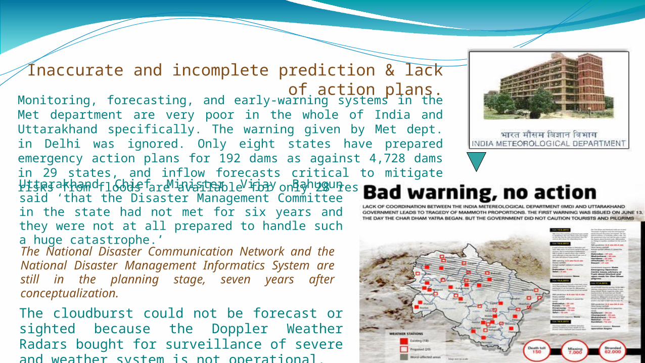
Inaccurate and incomplete prediction & lack of action plans.Monitoring, forecasting, and early-warning systems in the Met
department are very poor in the whole of India and Uttarakhand specifically. The warning given by Met dept. in Delhi was ignored. Only eight states have prepared emergency action plans for 192 dams as against 4,728 dams in 29 states, and inflow forecasts critical to mitigate risks from floods are available for only 28 reservoirs.Uttarakhand Chief Minister Vijay Bahugun said ‘that the Disaster Management Committee in the state had not met for six years and they were not at all prepared to handle such a huge catastrophe.’
The cloudburst could not be forecast or sighted because the Doppler Weather Radars bought for surveillance of severe and weather system is not operational.
The National Disaster Communication Network and the National Disaster Management Informatics System are still in the planning stage, seven years after conceptualization.

Only 4,000 army personnel had been deployed on duty. And only 100 police men were trained in emergency medical procedures while there was no one who was trained to manage a natural calamity.Rescue teams were using
satellite phones of the Army is because the satellite communication network is not functional.
The army and ITBP had to be called in because NDRF is hampered by shortage of manpower. Worse, only seven states had a State Disaster Response Force.
insufficient resources

One of the scientific studies of 1,317 glaciers by Indian Defense Research Organization in 10 sub-basins since 1962 of Indian Himalayan region finds 16% glaciers shrank during last 50 years. This study finds that in 100 years period there is 1.6°c rise in temperature, the precipitation rate has increased and rate of snowfall decreased, leading to reduced river discharge.
Wildlife Institute of India report (2012) recommended that 24 of the 70 Upper Ganga projects should be shelved because of their high ecological impact. They together affect nearly 10,000 hectares of land in this small state, and submerge more than 3,600 hectares of forests.
Early warnings ignored...

The toll on us...

Landslides due to the floods, damaged several houses and structures, killing those who were trapped. The heavy rains resulted in large flash floods and massive landslides. Environment engineer and Ganga crusader, G D Agarwal, says that construction along the Ganga has certainly cost a lot more if one includes the cost of damage to environment. People have completely destroyed the ecology of the mountains. “We see more landslides nowadays because of unplanned development in the hills,” he says.
Landslides
The Himalayan region consists of extremely fragile ecosystems, and source to 10 major Asian river systems. 1.3 billion people rely for sustenance, water, livelihoods and prosperity, and this flood primarily means loss of major parts of that.

95% of the casualties occurred in Uttarakhand. 90 per cent of cash crops, particularly the apple crop, has
been completely destroyed by the floods. Loss to the public and private property estimate around Rs
2,575 crores as mentioned by the government, June 30, 2013. Insurance companies are looking at claims worth more than Rs 1,000 crore
Hundreds of porters and over 2,000 ponies are still untraceable. A total of 2145 animal loss and 185 animal owners have been affected.
Death & destruction


01/12/13
Rescue
&
Response

01/12/13
A big salute to the Indian Army and Police for their tireless service to those in need.

01/12/13

01/12/13

01/12/13

01/12/13
TOURISM AT A HALT

01/12/13
OPINIONS, COMMENTS, EFFORTS, agenda

01/12/13
The mountains of Uttarakhand are fragile and new. Hence, Uttarakhand is inherently vulnerable to various kinds of disasters, such as high intensity rainfall, cloud bursts, landslides, flash floods and earthquakes. Its geology is ridden with fault lines. Climate change is increasing the frequency of extreme events. Developmental projects need to take this reality into account.
Hydro projects have magnified the effects of heavy rain in Uttarakhand. Mismanagement of operations of the Tehri dam has led to floods in downstream areas.
The situation in Uttarakhand is a clear evidential proof of how much damage could be caused when natural balance is disturbed. This is just another example of climate change where rapid deforestation could be one of the factors along with a large scale disturbance to hydrological cycle. The scenario in Uttarakhand must raise a question not only the government's pro-clearance attitude towards the large number of dams coming up in the state but the credibility of EIA or Environmental Impact Assessment Reports, based on which a large number of such projects are still getting the nod after much opposition by environment activists.
Borrowing from articles of

01/12/13
What the Wildlife Institute of India has to say:

01/12/13
What Environmentalists and Activists have to say:

Conclusion...Conclusion...
01/12/13


Containing such Himalayan Tsunamis Firstly, the Met. department needs to be better equipped to site
early warning signs, and so do all national climate panels, so as to be better prepared to tackle inevitable situations with strategic action plans.
Development should be regulated and should stir free from scarring the ecology of the region. The fragility of terrains such as Uttarakhand's must be taken into account.
There is need for the development of mechanisms for better management of tourism and the tourist.
There is definitely a lack of coordination for disaster management strategies at the local level.
Floods may be inevitable, but that doesn't mean they can't be managed. There is an urgent need of forming a ‘National Board for Himalayan Conservation and Development’ for integrated development of the Himalayas. Anil joshi, environmentalist.
Proper land use policies should also be framed in order to regulate construction activities in the floodplains of the rivers.
Strategy required for integrated development of the region: proper representation of ‘Van Panchayats’ on the National Board for Himalayan Conservation and Development and for the running of the programmes on the cultivation of medicinal plants and employment generation programmes.
Application of remote sensing technology for the development of holistic data base for agriculture, water, forests, pastures, landscapes and other natural resources for the sustainable management of Himalayas should be in place.

Green Development: We need to concentrate on areas like water-shed development and afforestation.
Green development is far more sustainable and equitable than profit driven development.
Lastly, these calamities and destruction may primarily be caused by nature but they are man-made too.
→ Global warming, greenhouse effect, melting of glaciers, deforestation etc., to begin with.
We don't realise the extent of the circumstances of our own activities.


references www.ercindia.org www.thehindubusinessline.com articles.timesofindia.indiatimes.com Www.downtoearth.org.in www.theguardian.com www.bgr.in www.tehelka.com www.thehindu.com www.indianexpress.com in.reuters.com www.ndtv.com reliefweb.int
Thank you.