Embed Size (px)
Citation preview
United States Department of the Interior Bureau of Land Management
Northeastern States Field Office LLESM03200
_______________________________________
Draft Environmental Assessment
NEPA #: DOI-BLM-Eastern States-0030-2016-0002-EA
Oil and Gas Leasing, Wayne National Forest,
Marietta Unit of the Athens Ranger District,
Monroe, Noble, and Washington Counties, Ohio
_____________________________________________________________________________________
Date: April 2016
Type of Action: Oil and Gas Leasing
Locations: Benton, Center, Green, Jackson, Lee, Perry, Summit, Washington, and Wayne Townships, Monroe County, Ohio
Lawrence and Liberty Townships, Washington County, Ohio Elk Township, Noble County, Ohio
________________________________________________________________________________________________________
Bureau of Land Management Northeastern States District
626 E. Wisconsin Ave., Suite 200 Milwaukee, WI 53202 414-297-4400 (phone)
414-297-4409 (fax)

DOI-BLM-Eastern States-0030-2016-0002-EA 1
MISSION STATEMENT
It is the mission of the Bureau of Land Management to sustain the health, diversity, and productivity of the public lands for the use and enjoyment of present and future generations.

DOI-BLM-Eastern States-0030-2016-0002-EA 2
Table i. Technical review. Program Reviewer Signature Date
Air Quality Ryan Hathaway Natural Resources Specialist
Soils Kyle Schumacher Natural Resources Specialist
Water Resources and Water Quality
Katie Kassander Natural Resources Specialists
Plant and Animal Habitat and Populations
Derek Strohl Natural Resources Specialist
Geology and Minerals Carolyn Helm Geologist
Wastes, Hazardous and Solid Kyle Schumacher Natural Resources Specialist
Socioeconomics and Environmental Justice
Derek Strohl Natural Resources Specialist
Cultural Resources/Paleontology
Jarrod Kellogg Archaeologist
Native American Religious Concerns
Jarrod Kellogg Natural Resources Specialist
Visual Resources and Scenic Quality
Kyle Schumacher Natural Resources Specialist
Recreation, Land Use and Noise Jarrod Kellogg Natural Resources Specialist
_____________________________________ ________________
Preparer Date
_____________________________________ _________________
Planning & Environmental Coordinator Date
_____________________________________ _________________
Associate District Manager Date
DOI-BLM-Eastern States-0030-2016-0002-EA 3
EXECUTIVE SUMMARY The Bureau of Land Management (BLM) proposes to lease up to approximately 40,000 federally-owned
minerals located in the Wayne National Forest, Athens Ranger District, Marietta Unit in Monroe, Noble,
and Washington Counties in Ohio. This approximate acreage figure represents the total amount of
federally-owned minerals that could be nominated and potentially be made available for leasing on the
Marietta Unit. Industry uses the BLM Expression of Interest (EOI) process to nominate federal minerals
for leasing. To date, industry has submitted over fifty EOIs for parcels located on the Marietta Unit
totaling approximately 18,000 acres. The BLM and the U.S. Forest Service (Forest Service) review deeds
on a parcel-by-parcel basis to verify federal mineral ownership as leasing nominations are received.
Mineral ownership is highly fragmented and complicated throughout the WNF. Approximately 59% of
the WNF surface ownership is underlain by private minerals. The remaining approximately 41% of
surface ownership is underlain by federal minerals. The federal government owns a 100% mineral
interest in approximately 10,000 acres and owns a partial mineral interest in approximately 8,200 acres
underlying NFS lands on the Marietta Unit, totaling more than 18,000 acres. There are current leases on
an additional 10,000 acres, which may be federally owned and more than 13,000 acres of reserved
minerals that will revert to the federal government in the future. The Proposed Action also applies to
the minerals that are reverting. The Forest Service has authority to purchase lands; therefore acreages
listed above are subject to change through time.
Under the Proposed Action, the BLM would offer for lease, at future BLM Eastern States competitive oil
and gas lease sales, nominated parcels that have been reviewed and approved by the BLM and the
Forest Service. In accordance with 43 Code of Federal Regulations (CFR) 3120, approved parcels will be
identified, along with any attached stipulations and notices, through a Notice of Competitive Lease Sale
that will be posted at least 90 days prior to a lease sale.
As there are at least 50 EOIs to nominate parcels on the Marietta Unit and due to the complicated
nature of the mineral estate on the Wayne National Forest, the final EA for this Proposed Action will be
used to lease nominated parcels on the Marietta Unit that will undergo review by BLM and the Forest
Service over the next few years. Any nominated parcels reviewed and approved for competitive leasing
by the BLM and Forest Service after the initial lease sale in which parcels are auctioned would be
addressed with a Determination of NEPA Adequacy (DNA) document tiered to the environmental
analysis in the final EA. Approved lease parcels would then be auctioned at future BLM Eastern States
competitive oil and gas lease sales.
The proposed leases would provide the lessee(s) exclusive rights to explore and develop oil and gas
reserves on the leases but do not authorize surface disturbing activities. Although there would be no
surface disturbance from the action of leasing, the Environmental Assessment (EA) analyzes a
reasonably foreseeable development scenario (RFDS) to address the anticipated environmental effects
from potential future oil and gas development. Before a lessee or operator conducts any surface-
disturbing activities related to the development of these leases, the Bureau of Land Management (BLM)
DOI-BLM-Eastern States-0030-2016-0002-EA 4
must first approve an application for permit to drill (APD) as specified in 43 CFR 3162. In an APD, an
applicant proposes to drill the well subject to the terms and conditions of the lease. Upon receipt of an
APD, the BLM conducts an onsite inspection with the applicant and the landowner. The Forest Service
and BLM would also conduct additional site-specific analysis in compliance with the National
Environmental Policy Act (NEPA) and the appropriate consultations under the Endangered Species Act
(ESA) and National Historic Preservation Act (NHPA) prior to approving the APD.
The purpose of the Proposed Action is to support the development of oil and natural gas resources that
are essential to meeting the nation’s future needs for energy. It is the policy of the BLM as mandated by
various laws, including the Mineral Leasing Act of 1920, as amended (30 United States Code [USC] 181 et
seq.), the Federal Land Policy and Management Act of 1976 (FLPMA), and the Energy Policy Act of 2005
to make mineral resources available for development to meet national, regional, and local needs. The
oil and gas leasing program managed by the BLM encourages the sustainable development of domestic
oil and gas reserves which reduces the dependence of the United States on foreign sources of energy as
part of its multiple-use and sustainable yield mandate. The leasing of federal minerals is vital to the
United States as it seeks to maintain adequate domestic production of this strategic resource. The
Proposed Action is therefore needed to respond to EOIs, consistent with the BLM’s mission and
requirement to evaluate nominated parcels and hold quarterly competitive lease sales for available oil
and gas lease parcels.
The Proposed Action and alternatives are in compliance with the Final Revised Land and Resource
Management Plan, Wayne National Forest (2006 Forest Plan) (U.S. Forest Service, 2006). The BLM was
a cooperating agency in development of the 2006 Forest Plan. This EA incorporates, where appropriate,
the information from that plan and associated NEPA documentation. This EA also incorporates the
information from a related review effort resulting in a Supplemental Information Report (SIR) on oil and
gas (U.S. Forest Service, 2012), prepared by the Forest Service in coordination with the BLM.
The anticipated environmental impacts of the Proposed Action and No Action Alternative are
summarized in Table ii.
Table ii. Anticipated environmental effects of Proposed Action and No Action Alternative.
Resource No Action Alternative
Proposed Action
Air Resources No effect No direct impacts from leasing. Potential for minor, short and long-term emissions from potential future construction activities and well completion, including National Ambient Air Quality Standards (NAAQS) criteria contaminants and hazardous air pollutants. Effects from emissions may include health hazards, reduced visibility, and contribution to global climate change. Effects minimized by Standard Operating Procedures (SOPs), best
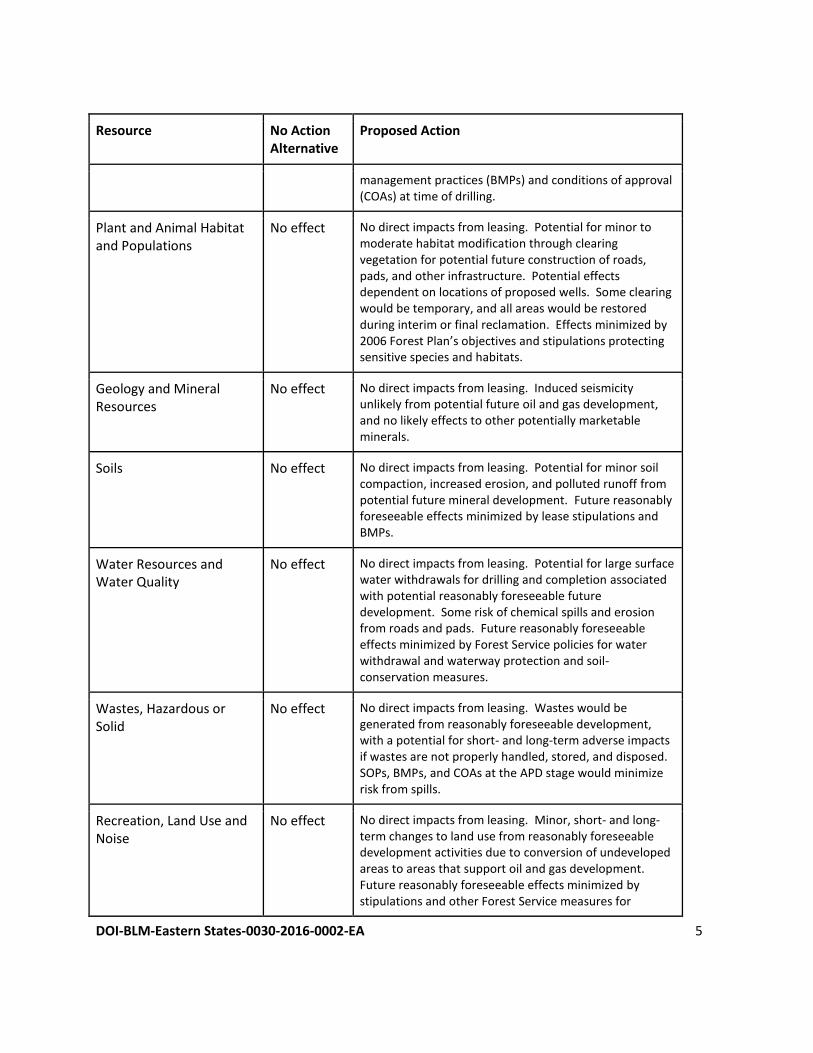
DOI-BLM-Eastern States-0030-2016-0002-EA 5
Resource No Action Alternative
Proposed Action
management practices (BMPs) and conditions of approval (COAs) at time of drilling.
Plant and Animal Habitat and Populations
No effect No direct impacts from leasing. Potential for minor to moderate habitat modification through clearing vegetation for potential future construction of roads, pads, and other infrastructure. Potential effects dependent on locations of proposed wells. Some clearing would be temporary, and all areas would be restored during interim or final reclamation. Effects minimized by 2006 Forest Plan’s objectives and stipulations protecting sensitive species and habitats.
Geology and Mineral Resources
No effect No direct impacts from leasing. Induced seismicity unlikely from potential future oil and gas development, and no likely effects to other potentially marketable minerals.
Soils No effect No direct impacts from leasing. Potential for minor soil compaction, increased erosion, and polluted runoff from potential future mineral development. Future reasonably foreseeable effects minimized by lease stipulations and BMPs.
Water Resources and Water Quality
No effect No direct impacts from leasing. Potential for large surface water withdrawals for drilling and completion associated with potential reasonably foreseeable future development. Some risk of chemical spills and erosion from roads and pads. Future reasonably foreseeable effects minimized by Forest Service policies for water withdrawal and waterway protection and soil-conservation measures.
Wastes, Hazardous or Solid
No effect No direct impacts from leasing. Wastes would be generated from reasonably foreseeable development, with a potential for short- and long-term adverse impacts if wastes are not properly handled, stored, and disposed. SOPs, BMPs, and COAs at the APD stage would minimize risk from spills.
Recreation, Land Use and Noise
No effect No direct impacts from leasing. Minor, short- and long-term changes to land use from reasonably foreseeable development activities due to conversion of undeveloped areas to areas that support oil and gas development. Future reasonably foreseeable effects minimized by stipulations and other Forest Service measures for
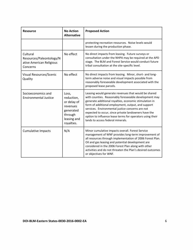
DOI-BLM-Eastern States-0030-2016-0002-EA 6
Resource No Action Alternative
Proposed Action
protecting recreation resources. Noise levels would lessen during the production phase.
Cultural Resources/Paleontology/Native American Religious Concerns
No effect No direct impacts from leasing. Future surveys or consultation under the NHPA may be required at the APD stage. The BLM and Forest Service would conduct future tribal consultation at the site-specific level.
Visual Resources/Scenic Quality
No effect No direct impacts from leasing. Minor, short- and long-term adverse noise and visual impacts possible from reasonably foreseeable development associated with the proposed lease parcels.
Socioeconomics and Environmental Justice
Loss, reduction, or delay of revenues generated through leasing and royalties.
Leasing would generate revenues that would be shared with counties. Reasonably foreseeable development may generate additional royalties, economic stimulation in form of additional employment, output, and support services. Environmental justice concerns are not expected to occur, since private landowners have the option to influence lease terms for operators using their lands to access federal minerals.
Cumulative Impacts N/A Minor cumulative impacts overall. Forest Service management of WNF provides long-term improvement of all resources through implementation of 2006 Forest Plan. Oil and gas leasing and potential development are considered in the 2006 Forest Plan along with other activities and do not threaten the Plan’s desired outcomes or objectives for WNF.
DOI-BLM-Eastern States-0030-2016-0002-EA 7
Acronyms AMD – Acid Mine Drainage AMDAT - Acid Mine Drainage Abatement and Treatment AML - Abandoned Mine Land APD – Application for Permit to Drill ATV – All Terrain Vehicle BE – Biological Evaluation BLM - Bureau of Land Management BMP – Best Management Practice BO – Biological Opinion CAA - Clean Air Act CAIR – Clean Air Interstate Rule CFR - Code of Federal Regulations CEQ – Council on Environmental Quality CERCLA - Comprehensive Environmental Response Compensation and Liability Act CH4 - Methane CO – Carbon Monoxide CO2 – Carbon Dioxide CO2e – Carbon Dioxide Equivalent CSAPR – Cross-State Air Pollution Rule CWA - Clean Water Act DAPC – Division of Air Pollution Control DNA-Determination of NEPA Adequacy DOGRM - Division of Oil and Gas Resources Management DOI - Department of the Interior DR – Decision Record EA - Environmental Assessment EO - Executive Order EOI – Expression of Interest EPA – Environmental Protection Agency ESA - Endangered Species Act ESO - Eastern States Office FA – Flow Alteration FLPMA - Federal Land Policy and Management Act FONSI - Finding of No Significant Impact FOOGLRA - Federal Onshore Oil and Gas Leasing Reform Act GHG – Greenhouse Gas HA - Habitat Alterations
HF – Hydraulic Fracturing HUC – Hydraulic Unit Code HVHF – High-Volume Hydraulic Fracturing IBI - Index of Biotic Integrity ICI - Invertebrate Community Index LOC – Levels of Concern LRMP – Land and Resource Management Plan LUP – Land Use Plan MACT – Maximum Achievable Control Technology MBTA - Migratory Bird Treaty Act MIwb - Modified Index of Well-Being MLA - Mineral Leasing Act mm - millimeter NAAQS – National Ambient Air Quality Standards NAGPRA – Native American Graves Protection and Repatriation Act NEPA - National Environmental Policy Act NESHAP - National Emission Standards for Hazardous Air Pollutants NFS – National Forest System NHPA - National Historic Preservation Act NOx – Nitrogen Oxides NOI - Notice of Intent for Geophysical Exploration NSD - Northeastern States District O3 - Ozone ODNR – Ohio Department of Natural Resources OHV – Off-Highway Vehicle Pb – Lead PCBs - Polychlorinated Biphenyls PM – Particulate Matter PSD – Prevention of Significant Deterioration RCRA - Resource Conservation and Recovery Act RFDS – Reasonably Foreseeable Development Scenario SIO - Scenic Integrity Objectives SIP – State Implementation Plan SIR – Supplemental Information Report SMS - Scenery Management System SO2 – Sulfur Dioxide
DOI-BLM-Eastern States-0030-2016-0002-EA 8
Acronyms
SOP – Standard Operating Procedure TMDL - Total Maximum Daily Load
TSS - Total Suspended Solids TT - Total Toxics USC – United States Code USFWS - U.S. Fish and Wildlife Service UTV-Utility Task Vehicle VMS - Visual Management System VOC – Volatile Organic Compound VQO - Visual Quality Objectives VRM – Visual Resource Management WNF – Wayne National Forest
DOI-BLM-Eastern States-0030-2016-0002-EA 9
Contents EXECUTIVE SUMMARY .................................................................................................................................. 3
Acronyms ...................................................................................................................................................... 7
1. PURPOSE AND NEED ........................................................................................................................... 13
1.1. Introduction ................................................................................................................................ 13
1.2. Location of the Proposed Action................................................................................................. 13
1.3. Purpose and Need of the Proposed Action................................................................................. 14
1.4. Management Objectives of the Proposed Action ....................................................................... 14
1.5. Relationship to Statutes, Regulations, Land Use Plans, and Policy ............................................ 14
1.6. Decision to be Made ................................................................................................................... 15
1.7. Scoping and Issues ...................................................................................................................... 15
1.7.1. Internal scoping ................................................................................................................... 15
1.7.2. External scoping .................................................................................................................. 16
1.7.3. Public involvement .............................................................................................................. 16
1.7.4. Issues identified through public scoping............................................................................. 17
2. PROPOSED ACTION AND ALTERNATIVES ............................................................................................ 18
2.1. Proposed Action .......................................................................................................................... 18
2.2. Reasonably Foreseeable Development Scenario (RFDS) for Potential Oil and Gas Development
19
2.2.1 Phases of Oil and Gas Development ................................................................................... 22
2.3. No Action Alternative .................................................................................................................. 24
2.4. Alternatives Considered but not Analyzed in Detail ................................................................... 25
2.4.1. Offer all leases with a no-surface-occupancy stipulation ................................................... 25
2.4.2. Lease minerals for vertical drilling only .............................................................................. 25
3. DESCRIPTION OF THE AFFECTED ENVIRONMENT ............................................................................... 25
3.1. Land Use ...................................................................................................................................... 26
3.2. Air Resources .............................................................................................................................. 26
3.2.1. Air quality ............................................................................................................................ 26
3.2.2. Visibility ............................................................................................................................... 29
3.2.3. Atmospheric deposition ...................................................................................................... 31
DOI-BLM-Eastern States-0030-2016-0002-EA 10
3.2.4. Current pollution concentrations ....................................................................................... 31
3.2.5. Global climate change ......................................................................................................... 32
3.3. Plant and Animal Habitat and Populations ................................................................................. 35
3.3.1. Introduction ........................................................................................................................ 35
3.3.2. Oak-hickory forest ............................................................................................................... 37
3.3.3. Pine forest ........................................................................................................................... 37
3.3.4. Early successional habitat ................................................................................................... 38
3.3.5. Mature interior forest ......................................................................................................... 38
3.3.6. Mature, riparian forest/headwater streams ...................................................................... 38
3.3.7. Grassland habitat ................................................................................................................ 39
3.3.8. Species of viability concern ................................................................................................. 39
3.3.9. Species of public interest .................................................................................................... 46
3.3.10. Non-native, invasive species ............................................................................................... 46
3.4. Geology and Minerals ................................................................................................................. 47
3.4.1. Minerals .............................................................................................................................. 48
3.4.2. Mineral development ......................................................................................................... 49
3.5. Soils ............................................................................................................................................. 50
3.6. Water Resources and Water Quality .......................................................................................... 51
3.6.1. Surface water ...................................................................................................................... 51
3.6.2. Groundwater ....................................................................................................................... 55
3.6.3. Riparian areas ..................................................................................................................... 56
3.7. Wastes, Hazardous or Solid ........................................................................................................ 56
3.8. Recreation and Noise .................................................................................................................. 57
3.9. Cultural Resources/Paleontology ................................................................................................ 59
3.10. Native American Religious Concerns ...................................................................................... 60
3.11. Visual Resources and Scenic Quality ....................................................................................... 60
3.12. Socioeconomics and Environmental Justice ........................................................................... 61
4. ENVIRONMENTAL IMPACTS ................................................................................................................ 63
4.1. Introduction ................................................................................................................................ 63
4.2. Air Resources .............................................................................................................................. 64
DOI-BLM-Eastern States-0030-2016-0002-EA 11
4.2.1. Air quality ............................................................................................................................ 64
4.2.2 Visibility ............................................................................................................................... 66
4.2.3 Possible Future Best Management Practices, Standard Operating Procedures, and/or
Mitigation Measures ........................................................................................................................... 66
4.3. Plant and Animal Habitat and Populations ................................................................................. 67
4.3.1. Introduction ........................................................................................................................ 67
4.3.2. Oak-hickory forest ............................................................................................................... 68
4.3.3. Pine forest ........................................................................................................................... 68
4.3.4. Early-successional habitat ................................................................................................... 68
4.3.5. Mature interior forest ......................................................................................................... 68
4.3.6. Mature, riparian forest/headwater streams ...................................................................... 69
4.3.7. Grassland habitat ................................................................................................................ 69
4.3.8. Species of viability concern ................................................................................................. 70
4.3.9. Species of public interest .................................................................................................... 71
4.3.10. Non-native, invasive species ............................................................................................... 72
4.4. Geology and Minerals ................................................................................................................. 72
4.4.1 Possible Future Best Management Practices, Standard Operating Procedures, and/or
Mitigation Measures ........................................................................................................................... 73
4.5 Soils ............................................................................................................................................. 73
4.5.1 Possible Future Best Management Practices, Standard Operating Procedures, and/or
Mitigation Measures ........................................................................................................................... 73
4.6. Water Resources and Water Quality .......................................................................................... 74
4.6.1. Surface water ...................................................................................................................... 74
4.6.2. Groundwater ....................................................................................................................... 74
4.6.3. Riparian areas ..................................................................................................................... 75
4.7. Wastes, Hazardous or Solid ........................................................................................................ 75
4.7.1 Possible Future Best Management Practices, Standard Operating Procedures, and/or
Mitigation Measures ........................................................................................................................... 77
4.8. Recreation and Noise .................................................................................................................. 77
4.9. Cultural Resources/Paleontology ................................................................................................ 79
4.10. Native American Religious Concerns ...................................................................................... 79
DOI-BLM-Eastern States-0030-2016-0002-EA 12
4.11. Visual Resources/Scenic Quality ............................................................................................. 80
4.12. Socioeconomics ....................................................................................................................... 80
4.12.1. Economic stimulation from potential future construction and drilling activity ................. 80
4.12.2. Payments from the federal government ............................................................................ 82
4.12.3. Environmental justice ......................................................................................................... 83
4.13. Cumulative Effects .................................................................................................................. 84
4.13.1. Context for Cumulative Effects Analysis ............................................................................. 85
4.13.2. Cumulative Effects Analysis ................................................................................................ 86
4.14. Irreversible and Irretrievable Commitments of Resources ..................................................... 90
4.15. Relationship between Local Short-term Uses and Long-term Productivity ............................ 90
4.16. No action alternative for all resources.................................................................................... 91
5 LEASE-SPECIFIC OIL AND GAS NOTIFICATIONS AND STIPULATIONS ................................................... 91
Introduction ............................................................................................................................................ 91
Notifications ............................................................................................................................................ 91
Management Areas Requiring Special Stipulations ................................................................................ 93
Resources Requiring Special Stipulations ............................................................................................... 94
6 MAPS ................................................................................................................................................... 97
7 PERSONS, GROUPS, AND AGENCIES CONSULTED ................................................................................ 105
7.1 List of Persons, Agencies and Organizations Consulted ....................................................... 105
7.2 List of Preparers .................................................................................................................... 105
8 REFERENCES ...................................................................................................................................... 106
DOI-BLM-Eastern States-0030-2016-0002-EA 13
1. PURPOSE AND NEED
1.1. Introduction The Bureau of Land Management (BLM) has prepared this draft Environmental Assessment (EA) to
evaluate the anticipated environmental impacts of leasing federal mineral estate to support potential
future oil and gas development within the proclamation boundary of the Wayne National Forest (WNF),
Athens Ranger District, Marietta Unit, located in Monroe, Noble, and Washington Counties, Ohio
(Marietta Unit). Interested parties such as private individuals or companies may file Expressions of
Interest (EOIs) to nominate parcels for competitive bid and leasing by the BLM. The BLM has received
at least 50 EOIs to nominate parcels on the Marietta Unit and due to the complicated nature of the
mineral estate on the Wayne National Forest, the final EA for this Proposed Action will be used to lease
nominated parcels on the Marietta Unit that will undergo review by BLM and the Forest Service over the
next few years. Any nominated parcels reviewed and approved for competitive leasing by the BLM and
Forest Service after the initial lease sale in which parcels are auctioned would be addressed with a
Determination of NEPA Adequacy (DNA) document tiered to the environmental analysis in the final EA.
Approved lease parcels would then be auctioned at future BLM Eastern States competitive oil and gas
lease sales.
The parcels that could be leased as part of the Proposed Action consist of all federal mineral estate
underlying National Forest System (NFS) lands within the proclamation boundary of the Marietta Unit
and total approximately 40,000 acres. A federal oil and gas lease is a legal contract that grants exclusive
rights to the lessee to develop federally-owned oil and gas resources but does not authorize surface-
disturbing activities or obligate the lessee to drill a well on the parcel in the future. Should the parcel be
leased and a detailed plan for oil and gas development on the parcel be identified, the BLM and Forest
Service would conduct future site-specific environmental analysis prior to any ground disturbing
activities. The Proposed Action evaluated in this EA is described in further detail in Chapter 2.
This EA has been prepared in accordance with the National Environmental Policy Act (NEPA) of 1969; the
Council on Environmental Quality (CEQ) regulations implementing NEPA (40 Code of Federal Regulations
[CFR] Parts 1500-1508), the United States Department of the Interior (DOI) NEPA requirements
(Department Manual 516, Environmental Quality) and the BLM NEPA Handbook H-1790-1. The
information presented within this document serves as the basis for the BLM Authorized Officer to
decide whether the Proposed Action would result in significant impacts to the environment. Significant
impacts would, require the preparation of an Environmental Impact Statement (EIS). If the BLM
Authorized Officer determines that no significant impacts would occur, a Finding of No Significant
Impact (FONSI) would be issued
1.2. Location of the Proposed Action The Proposed Action is for lands located in Monroe, Noble, and Washington Counties in Ohio. Maps are
included in Chapter 6 of this EA. Map 1 depicts an overview of the WNF showing each ranger
DOI-BLM-Eastern States-0030-2016-0002-EA 14
district/unit proclamation boundary. Map 2 is an overview of the Marietta Unit. Map 3 indicates the
locations of EOIs on the Marietta Unit that have been received as of the release date of this EA.
1.3. Purpose and Need of the Proposed Action The purpose of the Proposed Action is to support the development of oil and natural gas resources that
are essential to meeting the nation’s future needs for energy. It is the policy of the BLM as mandated by
various laws, including the Mineral Leasing Act of 1920, as amended (30 United States Code [USC] 181 et
seq.), the Federal Land Policy and Management Act of 1976 (FLPMA), and the Energy Policy Act of 2005
to make mineral resources available for development to meet national, regional, and local needs. The
oil and gas leasing program managed by the BLM encourages the sustainable development of domestic
oil and gas reserves which reduces the dependence of the United States on foreign sources of energy as
part of its multiple-use and sustainable yield mandate.
The leasing of federal minerals is vital to the United States as it seeks to maintain adequate domestic
production of this strategic resource. Industry uses the BLM EOI process to nominate federal minerals
for leasing. The Proposed Action is consistent with the BLM’s mission and requirement to evaluate
nominated parcels and hold quarterly competitive lease sales for available oil and gas lease parcels.
1.4. Management Objectives of the Proposed Action The management objective of the Proposed Action is to make federal minerals available for
development in an environmentally sound manner.
1.5. Relationship to Statutes, Regulations, Land Use Plans, and Policy The Proposed Action and alternatives are in compliance with the 2006 Final Revised Land and Resource
Management Plan, Wayne National Forest (2006 Forest Plan) (U.S. Forest Service, 2006). The BLM was
a cooperating agency in development of the 2006 Forest Plan and its related Final Environmental Impact
Statement (2006 Forest Plan Final EIS) (U.S. Forest Service, 2005). This EA incorporates by reference
relevant information from the 2006 Forest Plan and the 2006 Forest Plan Final EIS. This EA also
incorporates information from a related review effort resulting in a Supplemental Information Report
(SIR) on oil and gas (U.S. Forest Service, 2012), prepared by the Forest Service in coordination with the
BLM. Goal 10.1 in the 2006 Forest Plan states, “Provide a supply of mineral commodities for current and
future generations, while protecting the long-term health and biological diversity of ecosystems.
Facilitate the orderly exploration, development, and production of mineral and energy resources on land
open to these activities” (2006 Forest Plan, p. 2-41).
In addressing environmental considerations of the Proposed Action, the BLM is guided by relevant
statutes (and their implementing regulations) and Executive Orders that establish standards and provide
guidance on environmental and natural resources management and planning. These include but are not
limited to the following:
DOI-BLM-Eastern States-0030-2016-0002-EA 15
● NEPA (1969) and the associated Council on Environmental Quality regulations at 43 CFR Parts
1500-1508
● FLPMA (1976) as amended and the associated regulations at 43 CFR Part 1600
● Mineral Leasing Act (MLA) (1920), as amended and supplemented (30 USC 181)
● National Historic Preservation Act (NHPA) (1966) as amended and the associated regulations at
36 CFR Part 800
● American Indian Religious Freedom Act
● Native American Graves Protection and Repatriation Act (NAGPRA) (1990)
● Endangered Species Act (ESA) (1973) as amended
● Clean Water Act (CWA) (1972) as amended
● Clean Air Act (CAA) (1970) as amended
● Federal Onshore Oil and Gas Leasing Reform Act (FOOGLRA) (1987)
● Migratory Bird Treaty Act (MBTA) (1918)
● Resource Conservation and Recovery Act (RCRA) (1976) as amended
● Executive Order (EO) 11988- Floodplain Management
● EO 11990 – Protection of Wetlands
● EO 12898 – Environmental Justice in Minority Populations and Low-Income Populations
● EO 13007 – Indian Sacred Sites
● Oil and Gas Leasing Reform – Land Use Planning and Lease Parcel Reviews (BLM WO IM 2010-
117)
1.6. Decision to be Made The BLM must decide whether or not to lease all or part of the federal minerals within the Athens
Ranger District Marietta Unit of the WNF at future competitive oil and gas lease sale(s). The BLM, in
coordination with the Forest Service, must also determine which stipulations and notices must be
attached to such leases. The BLM’s policy is to promote oil and gas development if it meets the
guidelines and regulations set forth by the NEPA of 1969 and other subsequent laws and policies passed
by the U.S. Congress.
1.7. Scoping and Issues
1.7.1. Internal scoping
A BLM interdisciplinary team consisting of Land Law Examiners, Natural Resource Specialists, NEPA
Specialists, Geologists, GIS Specialists, and Cultural Resources Specialists prepared this EA in
coordination with Forest Service personnel. The interdisciplinary team used various sources of
information to prepare the EA, including existing data inventories, online resources, and information
collected onsite. The BLM conducted site visits within the Marietta Unit on October 26 and 27, 2015 of
portions of the Marietta Unit that have already been requested for leasing to document the physical
characteristics of the area and collect information on baseline conditions. The BLM did not identify any
issues of concern from internal scoping or the site visits.
DOI-BLM-Eastern States-0030-2016-0002-EA 16
1.7.2. External scoping
The BLM conducted required consultation with the Ohio State Historic Preservation Office (SHPO) and
tribes. The BLM initiated consultation with the Ohio SHPO by letter dated November 16, 2015; the
SHPO has yet to respond to the letter. On November 6, 2015, the BLM sent certified letters to seven
federally recognized tribes who have a known connection to the area notifying them of the Proposed
Action and asking to identify any concerns with respect to the Proposed Action. To date the BLM has
received no responses. The following tribes were contacted:
● The Delaware Tribe of Indians
● The Delaware Nation
● The Shawnee Tribe
● The Eastern Shawnee Tribe of Oklahoma
● The Absentee Shawnee Tribe of Indians
● The Wyandotte Nation
● Peoria Tribe of Indians of Oklahoma
The Forest Service previously consulted with the U.S. Fish and Wildlife Service (FWS) under Section 7 of
the Endangered Species Act with respect to federally listed species. Since the BLM was a cooperating
agency in the 2006 Forest Plan, the consultation conducted with respect to the 2006 Forest Plan applies
to the Proposed Action analyzed in this EA. The FWS’s Biological Opinion (BO), dated November 22,
2005, provided a tiered approach to Section 7 consultation. The programmatic (Tier I) BO covers all the
activities described in the 2006 Forest Plan at a programmatic, non-site-specific level. As the Forest
Service (and, by extension, the BLM) analyzes particular projects, the Forest Service (and BLM) is
responsible for reinitiating consultation at the project level by submitting to the FWS the following:
● description of the Proposed Action and area affected;
● list of the species that may be affected and their locations;
● description of the nature of the potential effects;
● determination of the effects;
● cumulative total of incidental takes to date under the Tier I BO;
● description of additional actions that were not described in the Tier I BO.
1.7.3. Public involvement
The BLM invites public participation in the NEPA process. Consideration of the views and information of
all interested persons promotes open communication and enables more informed decision making. All
agencies, organizations, and members of the public having a potential interest in the Proposed Action,
including minority, low-income, disadvantaged, and Native American groups, are encouraged to
participate in the decision making process.
DOI-BLM-Eastern States-0030-2016-0002-EA 17
The BLM conducted external scoping for leasing through a series of public meetings, requesting public
comments, and through close coordination and data sharing with the Forest Service. Public notices
appeared in local newspapers including the Marietta Times, Athens Messenger, and the Ironton Tribune
for two consecutive weeks starting on November 1, 2015. The BLM also issued a press release to
various news outlets on November 2, 2015, notifying the public of dates, times, and locations of the
public meetings. Public meetings were held on November 17, 2015 in Marietta, November 18, 2015 in
Athens, and November 19, 2015 in Ironton. The primary purpose for these public meetings was to
provide information and gather public input regarding issues that the BLM should consider in this EA. At
each meeting, the BLM and the Forest Service provided information regarding proposed oil and gas
leasing activities throughout the WNF; displayed maps showing locations of requested leases and
posters detailing the administrative processes associated with EOIs, leasing, and the NEPA; and
answered inquiries regarding the project.
The BLM also created a project website for the EA in November 2015 that is accessible through the BLM
national NEPA register at
https://eplanning.blm.gov/epl-front-office/eplanning/nepa/nepa_register.do. The website provides links to documents, opportunities for public involvement, including methods for
comment submission, maps, EOI information, and links to additional project information.
The BLM Eastern States Office (ESO) leasing process and policy incorporates a mandatory 30-day public
comment period on all completed EAs and unsigned FONSIs. The documents were made available April
28, 2016 for public review and a comment period ending May 29, 2016.
1.7.4. Issues identified through public scoping
The BLM received approximately 3,400 responses during its scoping period (November 1, 2015 to
January 22, 2016), which included three public meetings in November 2015. Many of these comments
reflected common themes, which are summarized below:
1. Oil and gas activities will disturb forestlands and degrade the wildlife habitats of the WNF.
2. Oil and gas activities will cause toxic chemicals to be spilled or be discharged into the
environment, threatening wildlife populations, degrading water quality, and harming human
health.
3. Oil and gas activities will create air pollution.
4. Oil and gas activities will degrade recreational opportunities and the visual character of the
WNF.
5. Leasing should be delayed until the oil and gas market improves.
6. Enabling oil and gas activities will provide private landowners the opportunity to develop their
minerals, and withholding leasing the federal minerals will pose an obstacle to development of
private minerals.
DOI-BLM-Eastern States-0030-2016-0002-EA 18
7. Restricting development of oil and gas minerals prohibits economic growth for the state of
Ohio.
The BLM has considered comments received during the scoping period in the development of this draft
EA. Following the conclusion of the 30-day public comment period for the draft EA, the BLM will analyze
and incorporate (where appropriate) all substantive comments received during the public comment
period and changes to the document are made, if necessary, and the EA becomes final.
2. PROPOSED ACTION AND ALTERNATIVES The CEQ’s Regulations for Implementing the Procedural Provisions of the National Environmental Policy
Act establish a number of policies for federal agencies, including “using the NEPA process to identify and
assess reasonable alternatives to the Proposed Action that would avoid or minimize adverse effects of
these actions on the quality of the human environment” (40 CFR 1500.2 (e)). This chapter provides a
detailed description of the Proposed Action and alternatives carried forward for analysis in the EA, as
well as the alternatives considered but dismissed.
2.1. Proposed Action The Bureau of Land Management (BLM) proposes to lease up to approximately 40,000 federally-owned
minerals located in the Wayne National Forest, Athens Ranger District, Marietta Unit in Monroe, Noble,
and Washington Counties in Ohio. This approximate acreage figure represents the total amount of
federally-owned minerals that could be nominated and potentially be made available for leasing on the
Marietta Unit. Industry uses the BLM Expression of Interest (EOI) process to nominate federal minerals
for leasing. To date, industry has submitted over fifty EOIs totaling approximately 18,000 acres for
parcels located on the Marietta Unit (see Map 3 in Chapter 6 of this EA). The BLM and the U.S. Forest
Service (Forest Service) review deeds on a parcel-by-parcel basis to verify federal mineral ownership as
leasing nominations are received.
Under the Proposed Action, the BLM would offer for lease, at future BLM Eastern States competitive oil
and gas lease sales, nominated parcels that have been reviewed and approved by the BLM and the
Forest Service. In accordance with 43 CFR 3120, approved parcels will be identified, along with any
attached stipulations and notices, through a Notice of Competitive Lease Sale that will be posted at least
90 days prior to a lease sale.
Mineral ownership is highly fragmented and complicated throughout the WNF. Approximately 59% of
the WNF surface ownership is underlain by private minerals. The remaining approximately 41% of
surface ownership is underlain by federal minerals. The federal government owns a 100% mineral
interest in approximately 10,000 acres and owns a partial mineral interest in approximately 8,200 acres
underlying NFS lands on the Marietta Unit, totaling more than 18,000 acres. There are current leases on
an additional 10,000 acres, which may be federally owned and more than 13,000 acres of reserved
DOI-BLM-Eastern States-0030-2016-0002-EA 19
minerals that will revert to the federal government in the future. The Proposed Action also applies to
the minerals that are reverting. The Forest Service has authority to purchase lands; therefore acreages
listed above are subject to change through time.
The proposed leases would provide the lessee(s) exclusive rights to explore and develop oil and gas
reserves on the lease but do not authorize surface disturbing activities. The lease owner/operator is
required under 43 CFR 3162 to obtain approval of an application for permit to drill (APD) before
conducting any surface disturbing activities. Upon receipt of an APD, the BLM conducts an onsite
inspection with the applicant in cooperation with the landowner. The BLM also conducts site-specific
NEPA analysis and the appropriate consultations under the ESA and NHPA prior to approving the APD.
Although there would be no surface disturbance from the action of leasing, the EA analyzes a reasonably
foreseeable development scenario (RFDS) to address the potential environmental effects from potential
future oil and gas development. For example, estimates can be made on the most likely number of
wells that could be constructed, but the specific locations cannot be determined until APDs are filed.
The detailed RFDS is included as an appendix to the 2006 Forest Plan, and a summary of the RFDS is
included below in Section 2.2.
Oil and gas leases are issued for a 10-year period and continue for as long thereafter as oil or gas is
produced in paying quantities.
2.2. Reasonably Foreseeable Development Scenario (RFDS) for Potential Oil
and Gas Development The Proposed Action is located in Monroe, Noble, and Washington Counties, Ohio, within the
proclamation boundary of the Athens Ranger District, Marietta Unit of the WNF. The area contains both
Forest Service and private surface overlaying federal minerals. The future development of the area
depends on many factors but this EA uses the RFDS developed as part of the 2006 Forest Plan Final EIS
(Appendix G) and the updated 2012 SIR for oil and gas to analyze the anticipated impacts of future oil
and gas development in the Marietta Unit. The 2012 SIR covered several resources of concern in
relationship to the use of horizontal drilling and high-volume hydraulic fracturing (HVHF) technology:
• Water resources • Wildlife • Fragmentation (an impact that affects wildlife habitat) • Botany • Waste disposal • Noise and light pollution • Air quality • Infrastructure/transportation • Public safety • Heritage • Soils
DOI-BLM-Eastern States-0030-2016-0002-EA 20
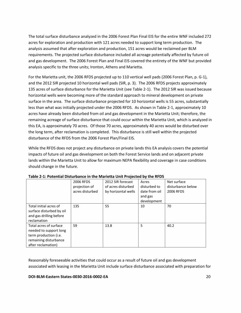
The total surface disturbance analyzed in the 2006 Forest Plan Final EIS for the entire WNF included 272
acres for exploration and production with 121 acres needed to support long term production. The
analysis assumed that after exploration and production, 151 acres would be reclaimed per BLM
requirements. The projected surface disturbance included all acreage potentially affected by future oil
and gas development. The 2006 Forest Plan and Final EIS covered the entirety of the WNF but provided
analysis specific to the three units; Ironton, Athens and Marietta.
For the Marietta unit, the 2006 RFDS projected up to 110 vertical well pads (2006 Forest Plan, p. G-1),
and the 2012 SIR projected 10 horizontal well pads (SIR, p. 3). The 2006 RFDS projects approximately
135 acres of surface disturbance for the Marietta Unit (see Table 2-1). The 2012 SIR was issued because
horizontal wells were becoming more of the standard approach to mineral development on private
surface in the area. The surface disturbance projected for 10 horizontal wells is 55 acres, substantially
less than what was initially projected under the 2006 RFDS. As shown in Table 2-1, approximately 10
acres have already been disturbed from oil and gas development in the Marietta Unit; therefore, the
remaining acreage of surface disturbance that could occur within the Marietta Unit, which is analyzed in
this EA, is approximately 70 acres. Of those 70 acres, approximately 40 acres would be disturbed over
the long term, after reclamation is completed. This disturbance is still well within the projected
disturbance of the RFDS from the 2006 Forest Plan/Final EIS.
While the RFDS does not project any disturbance on private lands this EA analysis covers the potential
impacts of future oil and gas development on both the Forest Service lands and on adjacent private
lands within the Marietta Unit to allow for maximum NEPA flexibility and coverage in case conditions
should change in the future.
Table 2-1: Potential Disturbance in the Marietta Unit Projected by the RFDS
2006 RFDS projection of acres disturbed
2012 SIR forecast of acres disturbed by horizontal wells
Acres disturbed to date from oil and gas development
Net surface disturbance below 2006 RFDS
Total initial acres of surface disturbed by oil and gas drilling before reclamation
135 55 10 70
Total acres of surface needed to support long term production (i.e. remaining disturbance after reclamation)
59 13.8 5 40.2
Reasonably foreseeable activities that could occur as a result of future oil and gas development
associated with leasing in the Marietta Unit include surface disturbance associated with preparation for
DOI-BLM-Eastern States-0030-2016-0002-EA 21
drilling including construction of a road, drilling pad, and reserve pit. Constructed access roads normally
have a running surface width of approximately 24 feet; the length is dependent upon the well site
location in relation to existing roads or highways. The average length of road construction is
approximately 0.5 miles. Therefore, approximately two acres would likely be affected by road
construction. Typically seven acres are cleared and graded level for the construction of the drilling pad.
Each drilling pad could have up to eight lateral lines. If the well produces natural gas, and the flowline is
in the road, another 0.5 acres may be affected by flowline construction. These disturbances are typical
for private or federal ownership well pad locations but may be subject to adjustment based on site-
specific conditions, which have not yet been determined. The excavation reserve pit is typically about
five feet deep and is lined with bentonite clay to retain drilling fluids, circulated mud, and drill cuttings.
Plastic or butyl liners (or an equivalent), that meet state standards for thickness and quality, are used on
occasions when soils are determined incapable of holding pit fluids.
Drilling typically continues around the clock. Once drilling is completed, excess fluids are pumped out of
the pit and disposed of in a state authorized disposal site and the drill cuttings are buried. The RFDS
assumes that wells would be drilled by rotary drilling using mud as the circulating medium. Mud pumps
would be used to force mud down the drillpipe, thereby forcing the rock cuttings out the wellbore.
Water would likely be obtained from a local surface water source, such as the Ohio River, through a pipe
laid on the surface or by tanker trucks. Approximately 1,500 barrels of drilling mud would be typically
kept on the location. If water production is expected, then processing facilities may be needed on or
offsite.
During well pad construction, the topsoil would likely be stockpiled for use during restoration activities.
If the well is successful, the drill pad would be reduced to about 100 feet x 100 feet with the remaining
surface area, including the reserve pit, re-graded and restored as per the surface owner requirements.
A lease notice for the proposed lease encourages the use of non-invasive cover plants during all
restoration and stabilization activities. Final seed mixtures and plantings are determined with
recommendations from BLM with approval of the land owner. The remaining 100 feet x 100 feet pad
would be maintained for the life of the well. The life of a productive well may be 25 years. Following
abandonment, the pad is subject to the same restoration parameters.
Chapter 5 contains the lease stipulations and lease notices for the Forest Service surface. These
recommended lease stipulations and notices have been developed to provide general habitat protection
and setbacks to exclude sensitive habitats from oil and gas development. Additional surveys or
consultations may be required after site-specific proposals have been received by BLM during the
development phase.
DOI-BLM-Eastern States-0030-2016-0002-EA 22
2.2.1 Phases of Oil and Gas Development
Following is additional information on the phases of oil and gas development, from geophysical
exploration through site reclamation. While site-specific activities are not yet proposed or known, the
following types of activities have been considered in this EA for NEPA analysis.
Geophysical exploration and exploratory drilling occur in the first phases of mineral development.
Geophysical exploration is used to obtain detailed geologic information. A variety of exploration
methods are employed, ranging from placing electrodes in the ground, to detonating explosives to
create shockwaves, to employing specially constructed off-road vehicles to produce vibrations.
Exploratory drilling begins the actual development of the lease. An access road and a well pad are
constructed for each well, if needed. No geophysical exploration is expected in the Marietta unit since
there is a long history of oil and gas development.
In-field drilling of additional exploration wells typically occurs when initial exploratory drilling has
located oil and gas, to define the limits of the oil and gas reservoir. The process of in-field drilling is the
same as that employed for initial exploratory drilling, although new roads and well pads may not be
required in every instance. Wells may be drilled vertically, if the end of the well (bottom hole location)
is directly below the well pad; or directionally, if the well pad is not directly above the bottom hole
location. For example, federal minerals under a state park with a “no surface occupancy” stipulation
(i.e., no surface disturbance from mineral development is allowed on the state park itself) can be
accessed by either directional or horizontal drilling from a surface location outside of the park. In
horizontal drilling the wellbore may extend several thousand feet through the rock formation. For the
purpose of this analysis, the BLM has assumed a typical maximum horizontal length of 7,500 feet.
Roads are typically cleared to a width of 24 feet, with a running surface width of 12 to 16 feet. The
length is dependent upon the well pad location in relation to existing roads or highways. Land is cleared
and graded for pad construction. If the well is productive, additional land may be affected by pipeline
construction. The total number of disturbed acres for well pads for vertical wells drilled to the target
formations in the Marietta Unit is expected to be 0.69 to 1.1 acre, and well pads for horizontal wells
drilled to the Utica/Point Pleasant or Marcellus Shales are 3 to 5.5 acres and may contain up to 8 wells.
Very little in-field drilling is expected.
Well Stimulation/Hydraulic Fracturing (HF). Well Stimulation may be used to enhance oil and gas
recovery. Several methods of well stimulation could be used. HF is one of these methods that is
reasonably foreseeable for leases in the WNF. HF is the process of applying high pressure to a
subsurface formation via the wellbore, to the extent that the pressure creates fractures in the rock.
Typically the induced fractures will be propped open with a granular “proppant” to enhance fluid
connection between the well and formation. The process was developed experimentally in 1947 and
has been used routinely since 1950. The Society of Petroleum Engineers estimates that over one million
DOI-BLM-Eastern States-0030-2016-0002-EA 23
HF procedures have been completed in the United States and tens of thousands of horizontal wells have
been drilled and hydraulically fractured (IOM, 2014; King, 2012).
To ensure that oil and gas exploration and development is conducted in a safe and environmentally
sound manner, the BLM approves and regulates all drilling and completion operations, and related
surface disturbance on federal public lands. Prior to approving an NOI or APD, the BLM identifies all
potential subsurface formations that will be penetrated by the wellbore. This includes all groundwater
aquifers and any zones that would present potential safety or health risks that may need special
protection during drilling.
Once the geologic analysis is completed, the BLM reviews the proposed casing and cementing programs
to ensure the well construction design is adequate to protect the surface and subsurface environment,
including the potential risks identified by the geologist and all known or anticipated zones with potential
risks.
Before HF takes place, all casings from the surface to the bottom of the well bore are cemented and the
mechanical integrity of the well is tested. The cemented well is pressure tested to ensure there are no
leaks and a cement bond log is run to ensure the cement has bonded to the casing and the formation. If
the fracturing of the well is considered to be a “non-routine” fracture for the area, the BLM would be
onsite during those operations as well as when abnormal conditions develop during the drilling or
completion of a well.
Wells that undergo HF may be drilled vertically, horizontally, or directionally and the resultant fracture
induced by HF can be vertical, or horizontal, or both. Wells may extend to depths greater than 20,000
feet or less than 1,000 feet, and horizontal sections of a well may extend several thousand feet from the
production pad on the surface.
Drilling muds, drilling fluids, water, and HF fluids are stored in on-site tanks or lined pits during the
drilling and/or completion process. Equipment transport and setup can take several days, and the
actual HF and flowback process can occur in a few days up to a few weeks. For oil wells, the flowback
fluid from the HF operations is treated in an oil-water separator before it is stored in a lined pit or tank
located on the surface. Where gas wells are flowed back using a “green completion process,” fluids are
run through a multi-phase separator, which are then piped directly to enclosed tanks or to a production
unit.
Production begins only if oil and gas can be transported to a market and sold at a profit. Production
facilities may include one or more of the following: a well head, pumping equipment, a separation
system, pipelines, a metering system, storage facilities, water treatment and injection facilities, cathodic
protection systems, electrical distribution lines, compressor stations, communication sites, roads, salt
water disposal systems, dehydration sites, and fresh/salt water plant sites. Drilling typically continues
around the clock. The RFDS assumes that wells would be drilled by rotary drilling using mud as the
DOI-BLM-Eastern States-0030-2016-0002-EA 24
circulating medium. Mud pumps would be used to force mud down the drillpipe, thereby forcing the
rock cuttings out the wellbore. Water would normally be obtained from a well drilled on the site,
however, water could be pumped to the site from a local pond, stream, river or lake through a pipe laid
on the surface. Approximately 1,500 barrels of drilling mud would be typically kept on the location. If
water production is expected, then processing facilities may be needed on the site. Once drilling is
completed, excess fluids are pumped out of the pit and disposed of in a state authorized disposal site
and the cuttings are buried.
Well abandonment may be temporary or permanent. Wells are sometimes shut-in because pipelines or
roads needed for production and marketing do not exist and the cost for construction is not justified by
the quantity of oil discovered. These wells may later be reentered when their production can be
marketed. The permanent abandonment of a well occurs when the well is determined to no longer
have a potential for economic production, or when the well cannot be used for other purposes.
Reclamation involves revegetation and recontouring of disturbed areas. During well pad construction,
the topsoil would likely be stockpiled for use during restoration activities. If the well is successful, the
drill pad would be reduced to about 100 feet x 100 feet with the remaining surface area, including the
reserve pit, re-graded and restored as per the surface owner requirements. The BLM encourages the
use of non-invasive cover plants during all restoration and stabilization activities. Final seed mixtures
and plantings are determined with recommendations from BLM with approval of the surface owner.
The remaining 100 feet x 100 feet pad would be maintained for the life of the well. The life of a
productive well may be 25 years. Following abandonment, the pad is subject to the same restoration
parameters.
2.3. No Action Alternative Under the No Action Alternative, the BLM would not offer the proposed parcels for oil and gas leasing,
nor would any future federal minerals be made available in the Marietta Unit. Ongoing oil and gas
development would, however, likely continue on surrounding areas and it is likely that the same or
nearly the same amount of development as described under the Proposed Action would occur on the
adjacent private lands whether or not the federal minerals are accessed. The difference between the
Proposed Action and No Action Alternative is that without the lease (No Action Alternative), the
operators would not be authorized to access the federal minerals at the time of development but could
continue to develop the adjacent privately owned minerals resulting in drainage of federal minerals
without any benefit to the government. Not leasing the parcel would not meet the purpose of and need
for the Proposed Action. CEQ guidelines stipulate that a No Action Alternative should be analyzed to
assess any environmental consequences that may occur if the Proposed Action is not implemented and
to serve as a baseline for comparing impacts of the Proposed Action. Therefore, the No Action
Alternative has been retained for analysis in this EA.
DOI-BLM-Eastern States-0030-2016-0002-EA 25
2.4. Alternatives Considered but not Analyzed in Detail
2.4.1. Offer all leases with a no-surface-occupancy stipulation
Offering all leases with a no-surface-occupancy (NSO) stipulation was suggested through public
comment; however, this alternative would not fulfill the purpose and need described in Chapter 1, for
various reasons. First, requiring all future drilling to take place off the federal surface may force
operators to use locations that result in greater adverse impacts to natural resources compared to
impacts on the federal surface. Impacts from oil and gas development on federal surface would be
minimized by the leasing stipulations provided in the 2006 Forest Plan. Second, the federal government
has more authority to protect natural resources on federal lands than on private lands. As nominated
parcels are reviewed, the BLM, in coordination with the Forest Service, determine which stipulations
and notices must be attached to approved lease parcels, including, where appropriate, NSO stipulations.
2.4.2. Lease minerals for vertical drilling only
As detailed in the findings from the 2012 SIR, which is incorporated by reference in Chapters 3 and 4,
measures already existing in the 2006 Forest Plan and the Final EIS, along with existing laws, rules, and
regulations, allow for the surface effects to be managed so that they are within the range already
analyzed in the 2006 Forest Plan Final EIS (2012 SIR Findings, p 2).
3. DESCRIPTION OF THE AFFECTED ENVIRONMENT This chapter describes the environment that would be affected by implementation of the Proposed
Action, as required by CEQ regulations for implementing NEPA (40 CFR Parts 1500-1508). The discussion
in this chapter focuses on the relevant resources and issues and only those elements of the affected
environment that have the potential to be impacted are described in detail.
Based on a review of the context and scale of the Proposed Action, the following resources are
discussed in detail in this EA: Land Use; Air Resources; Plant and Animal Habitat and Populations;
Geology and Minerals; Soils; Water Resources and Water Quality; Wastes, Hazardous or Solid;
Recreation and Noise; Cultural Resources/Paleontology; Native American Religious Concerns; Visual
Resources and Scenic Quality; and Socioeconomics and Environmental Justice.
Under the Proposed Action, operators could choose to locate potential future well pads and other
infrastructure on land owned by the WNF or on adjacent private lands within the WNF. If infrastructure
is located on adjacent private lands, the minerals would be accessed by directional or horizontal drilling.
For this reason, the potential area of effect includes the entire proclamation boundary of the Marietta
Unit of the WNF (Map 2; see Chapter 6 of this EA). The description of the affected environment
presented in this chapter includes information from and refers to the 2006 Forest Plan Final EIS, with
additional information provided to update and augment the 2006 Forest Plan Final EIS where applicable.
DOI-BLM-Eastern States-0030-2016-0002-EA 26
3.1. Land Use The Marietta Unit lies mostly within the Ohio Valley Lowlands Subsection of the Southern Unglaciated
Allegheny Plateau Section. This subsection is characterized by steep, wooded lands with high-gradient,
often ephemeral streams. Ongoing uses of the land in the WNF include timber harvest, recreation, and
mineral development.
3.2. Air Resources
3.2.1. Air quality
The primary sources of air pollution in the United States are dust from blowing wind on disturbed or
exposed soil, exhaust emissions from motorized equipment, oil and gas development, agriculture, and
industrial sources. The United States Environmental Protection Agency (EPA) was given the authority for
air quality protection with the provision to delegate this authority to the state as appropriate under
federal law. Most of the authority for air quality protection in Ohio has been delegated to the Division
of Air Pollution Control (DAPC). The Clean Air Act (CAA) of 1970, as amended, requires the
establishment of National Ambient Air Quality Standards (NAAQS). NAAQS pollutants include carbon
monoxide (CO), nitrogen dioxide (NO2), ozone (O3), particulate matter (PM10 & PM2.5), sulfur dioxide
(SO2), and lead (Pb). The NAAQS pollutants are monitored in Ohio by the DAPC. The CAA identifies two
types of national ambient air quality standards. Primary standards define levels of air quality that the
Administrator of the EPA judges to be necessary, with an adequate margin of safety, to protect the
public health. Secondary standards define levels of air quality that the Administrator of the EPA judges
to be necessary to protect the public from any known or anticipated adverse effects of a pollutant. The
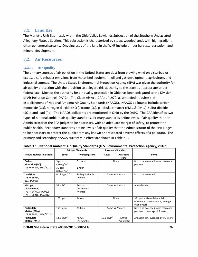
primary and secondary NAAQS currently in effect are shown in Table 3.1.
Table 3.1. National Ambient Air Quality Standards (U.S. Environmental Protection Agency, 2016f) Primary Standards Secondary Standards
Pollutant [final rule cited] Level Averaging Time Level Averaging Time
Form
Carbon Monoxide (CO) [76 FR 54294, 8/31/2011]
9 ppm (10 mg/m3)
8 hours None Not to be exceeded more than once per year
35 ppm (40 mg/m3)
1 hour
Lead (Pb) [73 FR 66964, 11/12/2008]
0.15 µg/m3 (1)
Rolling 3-Month Average
Same as Primary
Not to be exceeded
Nitrogen Dioxide (NO2) [75 FR 6474, 2/9/2010] [77 FR 20218, 4/3/2012]
53 ppb (2) Annual (Arithmetic Average)
Same as Primary Annual Mean
100 ppb 1-hour None 98th percentile of 1-hour daily
maximum concentrations, averaged over 3 years
Particulate Matter (PM10) [78 FR 3086, 12/14/2012]
150 µg/m3 24-hour Same as Primary Not to be exceeded more than once per year on average of 3 years
Particulate Matter (PM2.5)
12.0 µg/m3 Annual (Arithmetic
15.0 µg/m3 Annual (Arithmetic
Annual mean, averaged over 3 years
DOI-BLM-Eastern States-0030-2016-0002-EA 27
[78 FR 3086, 12/14/2012] Average) Average) 35 µg/m3 24-hour Same as Primary 98th percentile, averaged over 3
years Ozone (O3) [80 FR 65292, 11/26/2015]
0.070 ppm (3)
8-hour
Same as Primary
Annual fourth-highest daily maximum 8-hr average concentration, averaged over 3 years
Sulfur Dioxide (SO2) [75 FR 35520, 6/22/2010] [77 FR 20218, 4/3/2012]
75 ppb (4)
1-hour
0.5 ppm
3-hour
99th percentile of 1-hour daily maximum concentrations, averaged over 3 years Not to be exceeded more than once per year
(1) In areas designated nonattainment for the Pb standards prior to the promulgation of the current (2008) standards, and for which
implementation plans to attain or maintain the current (2008) standards have not been submitted and approved, the previous
standards (1.5 µg/m3 as a calendar quarter average) also remain in effect.
(2) The level of the annual NO2 standard is 0.053 ppm. It is shown here in terms of ppb for the purposes of clearer comparison to the 1-
hour standard level.
(3) Final rule signed October 1, 2015, and effective December 28, 2015. The previous (2008) O3 standards additionally remain in effect in
some areas. Revocation of the previous (2008) O3 standards and transitioning to the current (2015) standards will be addressed in
the implementation rule for the current standards.
(4) The previous SO2 standards (0.14 ppm 24-hour and 0.03 ppm annual) will additionally remain in effect in certain areas: (1) any area
for which it is not yet 1 year since the effective date of designation under the current (2010) standards, and (2)any area for which
implementation plans providing for attainment of the current (2010) standard have not been submitted and approved and which is
designated nonattainment under the previous SO2 standards or is not meeting the requirements of a SIP call under the previous SO2
standards (40 CFR 50.4(3)), A SIP call is an EPA action requiring a state to resubmit all or part of its State Implementation Plan to
demonstrate attainment of the require NAAQS.
According to the EPA (2016a), nationwide air quality has improved significantly for all common NAAQS
air pollutants since 1990 (Figure 1). Nationally, air pollution emissions were lower in 2014 than in 1990
for:
Carbon Monoxide (CO), by 62%
Nitrogen Oxides (NOx) , by 51%
Lead (Pb), by 80%
Volatile Organic Compounds (VOC) , by 38%
Direct PM10, by 19%
Direct PM2.5, by 25%
Sulfur Dioxide (SO2) , by 79%
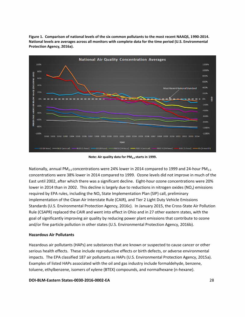
DOI-BLM-Eastern States-0030-2016-0002-EA 28
Figure 1. Comparison of national levels of the six common pollutants to the most recent NAAQS, 1990-2014. National levels are averages across all monitors with complete data for the time period (U.S. Environmental Protection Agency, 2016a).
Note: Air quality data for PM2.5 starts in 1999.
Nationally, annual PM2.5 concentrations were 24% lower in 2014 compared to 1999 and 24-hour PM2.5
concentrations were 38% lower in 2014 compared to 1999. Ozone levels did not improve in much of the
East until 2002, after which there was a significant decline. Eight-hour ozone concentrations were 20%
lower in 2014 than in 2002. This decline is largely due to reductions in nitrogen oxides (NOx) emissions
required by EPA rules, including the NOx State Implementation Plan (SIP) call, preliminary
implementation of the Clean Air Interstate Rule (CAIR), and Tier 2 Light Duty Vehicle Emissions
Standards (U.S. Environmental Protection Agency, 2016c). In January 2015, the Cross-State Air Pollution
Rule (CSAPR) replaced the CAIR and went into effect in Ohio and in 27 other eastern states, with the
goal of significantly improving air quality by reducing power plant emissions that contribute to ozone
and/or fine particle pollution in other states (U.S. Environmental Protection Agency, 2016b).
Hazardous Air Pollutants
Hazardous air pollutants (HAPs) are substances that are known or suspected to cause cancer or other
serious health effects. These include reproductive effects or birth defects, or adverse environmental
impacts. The EPA classified 187 air pollutants as HAPs (U.S. Environmental Protection Agency, 2015a).
Examples of listed HAPs associated with the oil and gas industry include formaldehyde, benzene,
toluene, ethylbenzene, isomers of xylene (BTEX) compounds, and normalhexane (n-hexane).
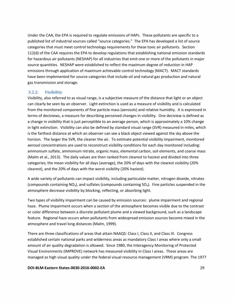
DOI-BLM-Eastern States-0030-2016-0002-EA 29
Under the CAA, the EPA is required to regulate emissions of HAPs. These pollutants are specific to a
published list of industrial sources called “source categories.” The EPA has developed a list of source
categories that must meet control technology requirements for these toxic air pollutants. Section
112(d) of the CAA requires the EPA to develop regulations that establishing national emission standards
for hazardous air pollutants (NESHAP) for all industries that emit one or more of the pollutants in major
source quantities. NESHAP were established to reflect the maximum degree of reduction in HAP
emissions through application of maximum achievable control technology (MACT). MACT standards
have been implemented for source categories that include oil and natural gas production and natural
gas transmission and storage.
3.2.2. Visibility
Visibility, also referred to as visual range, is a subjective measure of the distance that light or an object
can clearly be seen by an observer. Light extinction is used as a measure of visibility and is calculated
from the monitored components of fine particle mass (aerosols) and relative humidity. It is expressed in
terms of deciviews, a measure for describing perceived changes in visibility. One deciview is defined as
a change in visibility that is just perceptible to an average person, which is approximately a 10% change
in light extinction. Visibility can also be defined by standard visual range (SVR) measured in miles, which
is the farthest distance at which an observer can see a black object viewed against the sky above the
horizon. The larger the SVR, the cleaner the air. To estimate potential visibility impairment, monitored
aerosol concentrations are used to reconstruct visibility conditions for each day monitored including:
ammonium sulfate, ammonium nitrate, organic mass, elemental carbon, soil elements, and coarse mass
(Malm et al., 2013). The daily values are then ranked from clearest to haziest and divided into three
categories; the mean visibility for all days (average), the 20% of days with the clearest visibility (20%
clearest), and the 20% of days with the worst visibility (20% haziest).
A wide variety of pollutants can impact visibility, including particulate matter, nitrogen dioxide, nitrates
(compounds containing NO3), and sulfates (compounds containing SO4). Fine particles suspended in the
atmosphere decrease visibility by blocking, reflecting, or absorbing light.
Two types of visibility impairment can be caused by emission sources: plume impairment and regional
haze. Plume impairment occurs when a section of the atmosphere becomes visible due to the contrast
or color difference between a discrete pollutant plume and a viewed background, such as a landscape
feature. Regional haze occurs when pollutants from widespread emission sources become mixed in the
atmosphere and travel long distances (Malm, 1999).
There are three classifications of areas that attain NAAQS: Class I, Class II, and Class III. Congress
established certain national parks and wilderness areas as mandatory Class I areas where only a small
amount of air quality degradation is allowed. Since 1980, the Interagency Monitoring of Protected
Visual Environments (IMPROVE) network has measured visibility in Class I areas. These areas are
managed as high visual quality under the federal visual resource management (VRM) program. The 1977
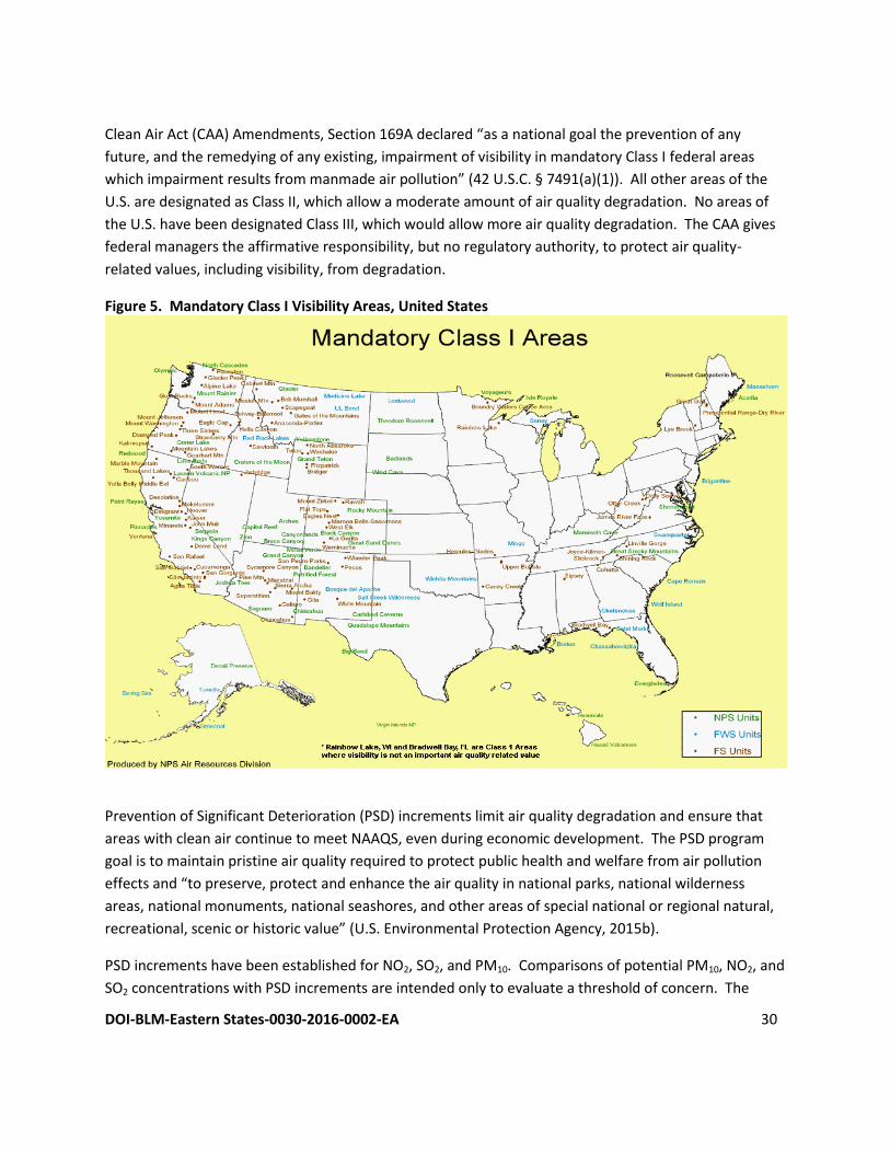
DOI-BLM-Eastern States-0030-2016-0002-EA 30
Clean Air Act (CAA) Amendments, Section 169A declared “as a national goal the prevention of any
future, and the remedying of any existing, impairment of visibility in mandatory Class I federal areas
which impairment results from manmade air pollution” (42 U.S.C. § 7491(a)(1)). All other areas of the
U.S. are designated as Class II, which allow a moderate amount of air quality degradation. No areas of
the U.S. have been designated Class III, which would allow more air quality degradation. The CAA gives
federal managers the affirmative responsibility, but no regulatory authority, to protect air quality-
related values, including visibility, from degradation.
Figure 5. Mandatory Class I Visibility Areas, United States
Prevention of Significant Deterioration (PSD) increments limit air quality degradation and ensure that
areas with clean air continue to meet NAAQS, even during economic development. The PSD program
goal is to maintain pristine air quality required to protect public health and welfare from air pollution
effects and “to preserve, protect and enhance the air quality in national parks, national wilderness
areas, national monuments, national seashores, and other areas of special national or regional natural,
recreational, scenic or historic value” (U.S. Environmental Protection Agency, 2015b).
PSD increments have been established for NO2, SO2, and PM10. Comparisons of potential PM10, NO2, and
SO2 concentrations with PSD increments are intended only to evaluate a threshold of concern. The
DOI-BLM-Eastern States-0030-2016-0002-EA 31
allowable PSD increment depends on an area’s classification. Class I areas have lower increments, due
to their protected status as pristine areas.
3.2.3. Atmospheric deposition
Atmospheric deposition refers to processes in which air pollutants are removed from the atmosphere
and deposited into terrestrial and aquatic ecosystems. Air pollutants can be deposited by precipitation
(rain and snow) or the gravitational settling of gaseous pollutants on soil, water, and vegetation. Much
of the concern about deposition is due to secondary formation of acids and other compounds from
emitted nitrogen and sulfur species, such as NOx and SO2, which can contribute to acidification of lakes,
streams, and soils and affect other ecosystem characteristics, including nutrient cycling and biological
diversity.
Substances deposited include:
• Acids, such as sulfuric (H2SO4) and nitric (HNO3), sometimes referred to as acid rain • Air toxics, such as pesticides, herbicides, and volatile organic compounds (VOC) • Heavy metals, such as mercury • Nutrients, such as nitrates (NO3) and ammonium (NH4+) The accurate measurement of atmospheric deposition is complicated by contributions to deposition by
several components including but not limited to rain, snow, cloud water, particle settling, and gaseous
pollutants. Deposition varies with precipitation and other meteorological variables (e.g., temperature,
humidity, winds, and atmospheric stability), which in turn, vary with elevation and time.
The Forest Service and the National Park Service have established guidelines for Levels of Concern (LOC)
for total deposition of nitrogen and sulfur compounds in Class I Wilderness Areas. Total nitrogen
deposition of up to 1.5 kilograms (kg) per hectare (ha) per year is considered unlikely to harm terrestrial
or aquatic ecosystems. For total sulfur deposition, the LOC is five kg/ha-yr. The USFS is considering a sulfur
LOC of 1.5 kg/ha-yr (U.S. Forest Service, National Park Service, and U.S. Fish and Wildlife Service, 2010).
3.2.4. Current pollution concentrations
The Marietta Unit in the WNF contains no Class I or sensitive Class II areas. Most of the area is in
attainment for NAAQS pollutants; however, Washington County is in non-attainment for Sulfur Dioxide
(Table 3.2) (U.S. Environmental Protection Agency, 2016g). The 2006 Forest Plan Final EIS also showed
Washington County in non-attainment for eight-hour ozone and particulate matter (these designations
were revoked in 2006 and 2012, respectively).
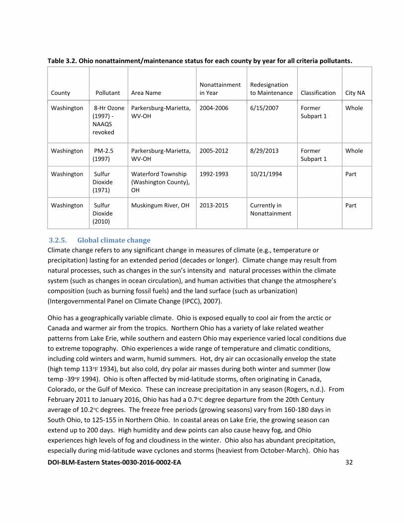
DOI-BLM-Eastern States-0030-2016-0002-EA 32
Table 3.2. Ohio nonattainment/maintenance status for each county by year for all criteria pollutants.
County Pollutant Area Name Nonattainment in Year
Redesignation to Maintenance Classification City NA
Washington 8-Hr Ozone (1997) -NAAQS revoked
Parkersburg-Marietta, WV-OH
2004-2006 6/15/2007 Former Subpart 1
Whole
Washington PM-2.5 (1997)
Parkersburg-Marietta, WV-OH
2005-2012 8/29/2013 Former Subpart 1
Whole
Washington Sulfur Dioxide (1971)
Waterford Township (Washington County), OH
1992-1993 10/21/1994 Part
Washington Sulfur Dioxide (2010)
Muskingum River, OH 2013-2015 Currently in Nonattainment
Part
3.2.5. Global climate change
Climate change refers to any significant change in measures of climate (e.g., temperature or
precipitation) lasting for an extended period (decades or longer). Climate change may result from
natural processes, such as changes in the sun’s intensity and natural processes within the climate
system (such as changes in ocean circulation), and human activities that change the atmosphere’s
composition (such as burning fossil fuels) and the land surface (such as urbanization)
(Intergovernmental Panel on Climate Change (IPCC), 2007).
Ohio has a geographically variable climate. Ohio is exposed equally to cool air from the arctic or
Canada and warmer air from the tropics. Northern Ohio has a variety of lake related weather
patterns from Lake Erie, while southern and eastern Ohio may experience varied local conditions due
to extreme topography. Ohio experiences a wide range of temperature and climatic conditions,
including cold winters and warm, humid summers. Hot, dry air can occasionally envelop the state
(high temp 113℉ 1934), but also cold, dry polar air masses during both winter and summer (low
temp -39℉ 1994). Ohio is often affected by mid-latitude storms, often originating in Canada,
Colorado, or the Gulf of Mexico. These can increase precipitation in any season (Rogers, n.d.). From
February 2011 to January 2016, Ohio has had a 0.7℃ degree departure from the 20th Century
average of 10.2℃ degrees. The freeze free periods (growing seasons) vary from 160-180 days in
South Ohio, to 125-155 in Northern Ohio. In coastal areas on Lake Erie, the growing season can
extend up to 200 days. High humidity and dew points can also cause heavy fog, and Ohio
experiences high levels of fog and cloudiness in the winter. Ohio also has abundant precipitation,
especially during mid-latitude wave cyclones and storms (heaviest from October-March). Ohio has
DOI-BLM-Eastern States-0030-2016-0002-EA 33
also had a 635 millimeter (mm) departure in precipitation from the 20th century average of
5,493.77mm (3rd wettest 60 Month period) (National Oceanic and Atmospheric Administration,
2016). Also of note, El Nino and La Nina events have had increasing effects on Ohio’s, and the
regional, climate.
Greenhouse gases (GHGs) are gases in the atmosphere composed of molecules that absorb and emit
infrared electromagnetic radiation. When present in the atmosphere, these gases contribute to the
greenhouse effect. The greenhouse effect is a process by which thermal radiation from a planetary
surface is absorbed by atmospheric GHGs and is re-radiated in all directions. Since part of this re-
radiation is back towards the surface and the lower atmosphere, it results in an elevation of the average
surface temperature above what it would be in the absence of the gases. Some GHGs such as CO2 occur
naturally and are emitted to the atmosphere through natural processes and human activities. Other
GHGs (e.g., fluorinated gases) are created and emitted solely through human activities. The primary
GHGs that enter the atmosphere as a result of anthropogenic activities include CO2, methane (CH4),
nitrous oxide (N2O), and fluorinated gases such as hydrofluorocarbons, perfluorocarbons, and sulfur
hexafluoride. Fluorinated gases are powerful GHGs that are emitted from a variety of industrial
processes including production of refrigeration/cooling systems, foams and aerosols. Fluorinated gases
are not primary to the activities authorized by the BLM and will not be discussed further in this
document.
In 2010, the U.S. Energy Information Administration (EIA) ranked Ohio fourth in the United States for
carbon dioxide emissions from fossil fuel consumption (2016). Ohio University and Ohio State University
collaborated on a GHG emissions inventory for the state of Ohio in 2011. The inventory used standard
approaches consistent with other state and EPA reporting inventory standards. The inventory also used
guidelines from the Intergovernmental Panel on Climate Change (IPCC) report (2006) which provides
conversion factors for CO2 equivalency for common GHGs. The inventory found that 93% of CO2e
(carbon dioxide equivalent) emissions were related to energy production, and the bulk of CO2 emissions
were the results of coal-fired power plants. Methane emissions were primarily from enteric
fermentation in agriculture and solid waste landfills. Nitrous oxide emissions were mostly from manure
management and manufacturing (Ohio University and The Ohio State University, 2011).
GHGs are commonly categorized as point, area, and mobile. These are often measured in their Carbon
Dioxide Equivalency (CO2e), a metric that uses the global warming potential of each substance and
relates it back to the equivalent. Of these, oil and gas factors into point and mobile (vehicle emissions
associated with construction and transport). Point emissions from oil and gas wells occur from fugitive
emissions during completion and production as well as from stationary equipment used in construction,
also from end uses such as energy production and residential heating. Mobile sources are trucks and
vehicles used in maintenance and transport after completion. Fugitive emissions from oil and gas were
quantified as 1.67 MMTs CO2e, and energy production accounted for 117.63 MMT (mostly attributed to
coal production). Monroe County contributed very little to the overall Ohio GHG emissions, but
DOI-BLM-Eastern States-0030-2016-0002-EA 34
Washington County was the second largest contributor in the southeast region of the state. Washington
County emissions were mostly attributed to energy production, likely from the two coal combustion
facilities (Muskingum River Power Plant and R.H. Gorsuch Station).
Ongoing scientific research has identified the potential impacts of anthropogenic GHG emissions and
changes in biological sequestration due to land management activities on global climate. Through
complex interactions on a regional and global scale, these GHG emissions and net losses of biological
carbon sinks may cause a net warming effect of the atmosphere, primarily by decreasing the amount of
heat energy radiated by the earth back into space. Although still debated, GHG levels have varied for
millennia, and it is theorized that recent industrialization and burning of fossil carbon sources have
caused CO2e concentrations to increase dramatically, and are likely to contribute to overall global
climatic changes. The IPCC (2007) concluded that “warming of the climate system is unequivocal” and
“most of the observed increase in global average temperatures since the mid-20th century is very likely
due to the observed increase in anthropogenic GHG concentrations.”
GHGs have a sustained climatic impact over different temporal scales. For example, recent emissions of
CO2 can influence climate for 100 years. In contrast, black carbon is a relatively short-lived pollutant, as
it remains in the atmosphere for only about a week. It is estimated that black carbon is the second
greatest contributor to global climate change behind CO2 (Ramanathan and Carmichael, 2008). Black
carbon is a highly light-absorbing component of particulate resulting from the incomplete combustion of
fossil fuels, biofuels, and biomass. Most black carbon in the Unites States comes from mobile sources
(diesel engines and vehicle use) or biomass burning (wildfires, residential heating, and industry) (U.S.
Environmental Protection Agency, 2012). Without additional meteorological monitoring systems, it is
difficult to determine the spatial and temporal variability and change of climatic conditions, but
increasing concentrations of GHGs may accelerate the rate of climate change in either a positive or
negative direction depending upon location and site specific factors.
Global mean surface temperatures have increased nearly 1.0°C (1.8°F) from 1890 to 2006 (National
Aeronautics and Space Administration Goddard Institute for Space Studies, 2007). In 2001, the IPCC
(2007) indicated that by the year 2100, global average surface temperatures would increase 1.4 to 5.8°C
(2.5 to 10.4°F) above 1990 levels. The National Academy of Sciences (Hansen et al., 2006) has confirmed
these findings, but also indicated that there are uncertainties regarding how climate change may affect
different regions. Observations and predictive models indicate that average temperature changes are
likely to be greater in the Northern Hemisphere. Data indicate that northern latitudes (above 24° N)
have exhibited temperature increases of nearly 1.2°C (2.1°F) since 1900, with nearly a 1.0°C (1.8°F)
increase since 1970 alone. It also shows temperature and precipitation trends for the conterminous
United States. For both parameters we see varying rates of change, but overall increases in both
temperature and precipitation.
DOI-BLM-Eastern States-0030-2016-0002-EA 35
The lack of scientific tools designed to predict climate change at regional or local scales limits the ability
to quantify potential future impacts. However, potential impacts to air quality due to climate change
are likely to be varied. Oil and gas development activities can generate CO2 and CH4. CO2 emissions
result from the use of combustion engines, while CH4 can be released during processing.
Because GHGs circulate freely throughout Earth’s atmosphere, the planning area for this resource is the
entire globe. The largest component of global anthropogenic GHG emissions is CO2. Global
anthropogenic carbon emissions reached about 7,000,000,000 metric tons per year in 2000 and an
estimated 9,170,000,000 metric tons per year in 2010 (Boden, Marland, & Andres, 2013). Oil and gas
production is a major contributor of GHGs. In 2006, natural gas production accounted for 8% of global
methane emissions, and oil production accounted for 0.5% of global methane emissions (URS
Corporation, 2010). A description of the potential GHG emissions associated with the proposed leasing
activities is included in Chapter 4.
3.3. Plant and Animal Habitat and Populations
3.3.1. Introduction
The description of plant and animal habitat and population information is derived from the 2006 Forest
Plan and incorporates by reference the supplemental information provided in the 2012 SIR.
The entire WNF harbors over 300 vertebrate species, although not all of them occur within the Marietta
Unit. The NFS lands are concentrated along ridges and sideslopes, and most of the streams on NFS lands
do not support large fish populations. The 2006 Forest Plan divides the WNF into 14 separate, non-
contiguous management areas, which are defined by their history, geography, suitability for various
types of use, and other factors. The Marietta Unit contains seven of these management areas, listed
below by acreage in descending order and shown on Map 4 (see Chapter 6 of this EA):
1. Diverse Continuous Forest. More than half of the Marietta Unit, or more than 114,000 acres, is
in this management area. This management area is characterized by large blocks of mature
forest with a variety of species and ages providing diverse wildlife habitat types. Management
of the Diverse Continuous Forest emphasizes habitat for forest interior species. Openings and
patches of early-successional habitat are present generally around the edges of otherwise
continuous blocks of mature forest. While wildland fire is used to promote oak and hickory
stand types, many stands are becoming increasingly dominated by maple and other fire-
intolerant species. Oil and gas development is permitted on NFS lands within this management
area. This management area in the Marietta Unit contains 160 acres of managed wildlife
openings, which are small breaks in forest canopy that are under special management for the
benefit of targeted wildlife species or habitat types.
2. Forest and Shrubland Mosaic. This management area, which includes about 68,000 acres in the
Marietta Unit, contains forests with a higher proportion of early- and mid-successional
component than the Diverse Continuous Forest management area. There are permanent
DOI-BLM-Eastern States-0030-2016-0002-EA 36
herbaceous openings dispersed throughout the forests, and prescribed fire and even-aged
timber harvests are used to ensure the desired amount of young habitat types. Oil and gas
development is permitted on NFS lands within this management area. This management area in
the Marietta Unit contains 49 acres of managed wildlife openings.
3. River Corridors. This management area, which includes 35,000 acres in the Marietta Unit,
follows the Little Muskingum and Ohio Rivers. The primary emphasis of this management area
is on habitats that comprise a healthy riparian area, such as floodplain forests, open wetlands,
and properly functioning stream channels. Oil and gas activities are permitted but are subject to
a controlled surface use stipulation. This management area in the Marietta Unit contains 112
acres of managed wildlife openings.
4. Future Old Forest with Mineral Activity. This management area, at 17,000 acres, is present
only on the Marietta Unit, due to the abundance of existing oil and gas wells, pads, and access
roads. This area contains a largely uneven-aged forest that is managed very non-intensively.
Over time, the area is expected to become dominated by maples and other fire-intolerant,
shade-tolerant species, while occasional, natural disturbances will maintain a small component
of early-successional habitat. This management area is closed to timber production and open
for oil and gas activities.
5. Special Areas. These areas are managed to preserve and study unique natural areas. There are
seven Special Areas in the Marietta Unit, totaling about 2,600 acres, mostly in the eastern half of
the Unit. Oil and gas activities are not permitted in this management area.
6. Developed Recreation. Two areas totaling 366 acres make up the federally-owned component
of Developed Recreation management area within the Marietta Unit. This management area
emphasizes providing safe areas for recreational activity. Oil and gas activities are not
permitted on new leases in this management area.
7. Research Natural Area. This management area consists of “nationally significant areas with
unique ecosystems deemed worthy of preservation for scientific purposes” (2006 Forest Plan, p.
3-53). The Marietta Unit contains one such area, known as Reas Run Research Natural Area, a
78-acre mature Virginia pine stand. Oil and gas activities are not permitted in this management
area.
The 2006 Forest Plan emphasizes that various habitat types and all major successional stages are
necessary for the WNF to meet its mandate of sustaining a diverse population of native plants and
animals. The 2006 Forest Plan analyzed several habitat indicators in an effort to summarize the impacts
of management activities:
● amount and trends in oak-hickory forest;
● amount and trends in pine forest and trends in pine warbler (Setophaga pinus) habitat and
population;
● amount and trends in early successional habitat and trends in yellow-breasted chat (Icteria
virens) and ruffed grouse (Bonasa umbellus, an upland game bird) habitat and populations;
DOI-BLM-Eastern States-0030-2016-0002-EA 37
● mature, interior forest ─ amount and trends cerulean warbler (Setophaga cerulea, a songbird)
and worm-eating warbler (Helmitheros vermivorum), and pileated woodpecker (Dryocopus
pileatus) habitat for and populations;
● mature riparian forest and headwater streams ─ amount and trends in Louisiana waterthrush
(Parkesia motacilla);
● grassland habitat ─ amount and trends in Henslow’s sparrow (Ammodramus henslowii)
population and habitat;
● species of viability concern ─ threatened and endangered species and Regional Forester
Sensitive Species;
● species of public interest, such as white-tailed deer and ginseng;
● non-native, invasive species;
● amount of Forest Service land open for timber harvesting;
● amount of Forest Service land open for prescribed burning.
For this EA, the BLM analyzed all of these indicators except the last two, since they relate strictly to
amounts of land allocated to certain land management practices, which are not affected by oil and gas
leasing or on-the-ground mineral activities.
3.3.2. Oak-hickory forest
Oak-hickory and mixed oak communities dominate the WNF (2006 Forest Plan Final EIS, p. 3-40). The
Southern Unglaciated Allegheny Plateau ecological section was dominated by oak-hickory and mixed
oak-pine communities at the time of first European settlement. The primary changes to the vegetation
since then have been the initial cutover of the primeval forest and the broad suppression of wildfire that
accompanied widespread European settlement. This second factor has resulted in the invasion of
maples, beech, and yellow poplar into the oak-dominated communities, to such an extent in many areas
that shade-intolerant, mast-bearing species (oaks and hickories) are declining. The primary factor in
maintaining oak-hickory forest is periodic disturbance, primarily harvest and fire, either wild or
prescribed.
3.3.3. Pine forest
Pine-dominated communities made up 6%, and mixed-pine communities 5% of the WNF in 2006 (2006
Forest Plan Final EIS, p. 3-55). As farms failed in southeastern Ohio in the 1930s, the Civilian
Conservation Corps planted pines widely as an erosion-control practice. Pines on the WNF include four
native species: shortleaf pine (Pinus echinata), pitch pine (P. rigida), Virginia pine (P. virginiana), and, in
the eastern portion of the Marietta unit, white pine (P. strobus). Red pine (P. resinosa) is not native to
Ohio but is widely planted and in present on the WNF. Pines are propagated by disturbances, such as
blowdown, fire, and timber harvest.
Pine warbler is identified by the Partners in Flights Northern American Landbird Conservation Plan as a
Stewardship Species for the Eastern Avifaunal Biome. This species has increased throughout the region
DOI-BLM-Eastern States-0030-2016-0002-EA 38
in the last half century. The 2006 Forest Plan Final EIS projects a decline in pine-dominated stands and
pine warbler population.
3.3.4. Early successional habitat
As in the case of oak-dominated and pine communities, early successional habitat types depend on
periodic disturbances. Disturbances such as fire and timber harvesting expose the ground to sunlight
and permit the growth of shrubby communities that favor certain types of wildlife. Wildfire once
provided periodic disturbance to a large portion of southern Ohio but has been widely suppressed over
the past century. Abandoned farms created a large component of early successional habitat, but this
component declined from 25% of the WNF in 1968 to the 2006 level of 5.4% (2006 Forest Plan Final EIS,
p. 3-60). A large component of current early successional habitat is on reclaimed mine lands. Yellow-
breasted chat and ruffed grouse are species of conservation concern on the WNF that require young
stands with open canopies. These and many other early successional forest birds have experienced
population declines as early successional habitat has given way to closed-canopy forests.
3.3.5. Mature interior forest
94% of the WNF and 80% of the surrounding landscape were forested in 2006 (2006 Forest Plan Final
EIS, p. 3-70). Mature forests have been increasing throughout southern Ohio over the last half century.
Most stands are even-aged or nearly so, since most stands originated following clearcuts or farm
abandonment. Many wildlife species thrive in mature forest conditions, and there is a wide variety of
types of structure in mature forests, such as semi-open canopies and tight canopies that provide dense
shade. The most abundant management area on the Marietta Unit is Diverse Continuous Forest, which
is managed to emphasize large blocks of unbroken forest.
Three bird species, cerulean warbler, worm-eating warbler, and pileated woodpecker, were selected as
indicators of mature forest conditions because they represent a broad cross-section of the habitat needs
of mature-forest-dependent wildlife. Cerulean warblers require uneven-aged forests with large trees for
cavity-nesting. Worm-eating warblers nest on the ground and require well-developed understory with
plenty of coarse, woody debris. Pileated woodpeckers favor old forests but will use less-mature
habitats. All of these birds protect large territories and require large, unbroken tracts of mature forest.
3.3.6. Mature, riparian forest/headwater streams
Riparian areas are the zones of interaction between the terrestrial and aquatic ecosystems, including the
floodplains and the land whose vegetation, microclimate, and wildlife are directly influenced by the
presence of the aquatic ecosystem. The WNF provided a GIS file showing riparian areas within the
Marietta Unit. There are almost 15,000 acres of riparian area within the Marietta Unit, and the Forest
Service manages 15 percent of this area. Most of the federally-managed riparian areas are forested, and
some of the lands in riparian areas are used for agriculture and roads.
Louisiana waterthrush is a bird species that lives in large riparian forests. The Louisiana waterthrush is
considered a good indicator of riparian area health because it eats insects that live in various
DOI-BLM-Eastern States-0030-2016-0002-EA 39
microhabitats that are present in a healthy riparian area. Louisiana waterthrush is listed as a
Stewardship Species in the Partners in Flight North American Landbird Conservation Plan with a goal of
maintaining its current population, and the species is considered stable on the WNF.
3.3.7. Grassland habitat
Periodic disturbances have created small patches of grassland in southeastern Ohio since before
European settlement, but extensive prairies are not considered a native community to this area. Much
of the grassland habitat on the WNF was created by reclaimed mine lands. The Marietta Unit does not
contain any of the WNF’s major prairie areas, and the Unit contains no land allocated to the Grassland
Forest Mosaic management area.
Henslow’s sparrow, a grassland-dependent species, has been declining in southeastern Ohio in recent
decades and is not known to be present on the Marietta Unit.
3.3.8. Species of viability concern
3.3.8.1. Federally endangered or threatened species
Sensitive species managed by the Forest Service include federally listed endangered, threatened, and
candidate species under the Endangered Species Act and Regional Forester Sensitive Species. The
Forest Service, including both the WNF and the Region 9, has previously consulted with the U.S. Fish and
Wildlife Service (FWS) under Section 7 of the Endangered Species Act with respect to federally listed
species. Since the BLM was a cooperating agency in the 2006 Forest Plan, the consultation conducted
with respect to the 2006 Forest Plan applies to the Proposed Action analyzed in this EA. The FWS’s BO,
dated November 22, 2005, lays out a tiered approach to Section 7 consultation. The programmatic (Tier
I) BO covers all the activities described in the 2006 Forest Plan at a programmatic, non-site-specific level.
As the Forest Service (and, by extension, the BLM) analyzes particular projects, the Forest Service (and
BLM) is responsible to reinitiate consultation at the project level by submitting to the FWS the following:
● description of the Proposed Action and area affected;
● list of the species that may be affected and their locations;
● description of the nature of the potential effects;
● determination of the effects;
● cumulative total of incidental takes to date under the Tier I BO;
● description of additional actions that were not described in the Tier I BO.
Table 3.3 lists the species that were covered in the 2005 BO and two additional species that the FWS
recommended the BLM include in new consultation for the proposed leasing action analyzed in this EA.
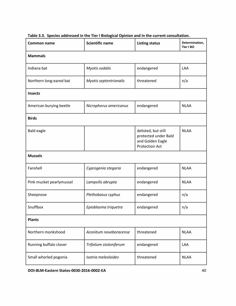
DOI-BLM-Eastern States-0030-2016-0002-EA 40
Table 3.3. Species addressed in the Tier I Biological Opinion and in the current consultation.
Common name Scientific name Listing status Determination, Tier I BO
Mammals
Indiana bat Myotis sodalis endangered LAA
Northern long-eared bat Myotis septentrionalis threatened n/a
Insects
American burying beetle Nicrophorus americanus endangered NLAA
Birds
Bald eagle delisted, but still protected under Bald and Golden Eagle Protection Act
NLAA
Mussels
Fanshell Cyprogenia stegaria endangered NLAA
Pink mucket pearlymussel Lampsilis abrupta endangered NLAA
Sheepnose Plethobasus cyphus endangered n/a
Snuffbox Epioblasma triquetra endangered n/a
Plants
Northern monkshood Aconitum noveboracense threatened NLAA
Running buffalo clover Trifolium stoloniferum endangered LAA
Small whorled pogonia Isotria meleoloides threatened NLAA
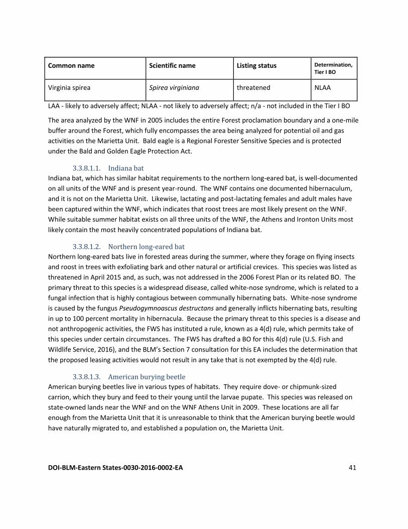
DOI-BLM-Eastern States-0030-2016-0002-EA 41
Common name Scientific name Listing status Determination, Tier I BO
Virginia spirea Spirea virginiana threatened NLAA
LAA - likely to adversely affect; NLAA - not likely to adversely affect; n/a - not included in the Tier I BO
The area analyzed by the WNF in 2005 includes the entire Forest proclamation boundary and a one-mile
buffer around the Forest, which fully encompasses the area being analyzed for potential oil and gas
activities on the Marietta Unit. Bald eagle is a Regional Forester Sensitive Species and is protected
under the Bald and Golden Eagle Protection Act.
3.3.8.1.1. Indiana bat
Indiana bat, which has similar habitat requirements to the northern long-eared bat, is well-documented
on all units of the WNF and is present year-round. The WNF contains one documented hibernaculum,
and it is not on the Marietta Unit. Likewise, lactating and post-lactating females and adult males have
been captured within the WNF, which indicates that roost trees are most likely present on the WNF.
While suitable summer habitat exists on all three units of the WNF, the Athens and Ironton Units most
likely contain the most heavily concentrated populations of Indiana bat.
3.3.8.1.2. Northern long-eared bat
Northern long-eared bats live in forested areas during the summer, where they forage on flying insects
and roost in trees with exfoliating bark and other natural or artificial crevices. This species was listed as
threatened in April 2015 and, as such, was not addressed in the 2006 Forest Plan or its related BO. The
primary threat to this species is a widespread disease, called white-nose syndrome, which is related to a
fungal infection that is highly contagious between communally hibernating bats. White-nose syndrome
is caused by the fungus Pseudogymnoascus destructans and generally inflicts hibernating bats, resulting
in up to 100 percent mortality in hibernacula. Because the primary threat to this species is a disease and
not anthropogenic activities, the FWS has instituted a rule, known as a 4(d) rule, which permits take of
this species under certain circumstances. The FWS has drafted a BO for this 4(d) rule (U.S. Fish and
Wildlife Service, 2016), and the BLM’s Section 7 consultation for this EA includes the determination that
the proposed leasing activities would not result in any take that is not exempted by the 4(d) rule.
3.3.8.1.3. American burying beetle
American burying beetles live in various types of habitats. They require dove- or chipmunk-sized
carrion, which they bury and feed to their young until the larvae pupate. This species was released on
state-owned lands near the WNF and on the WNF Athens Unit in 2009. These locations are all far
enough from the Marietta Unit that it is unreasonable to think that the American burying beetle would
have naturally migrated to, and established a population on, the Marietta Unit.
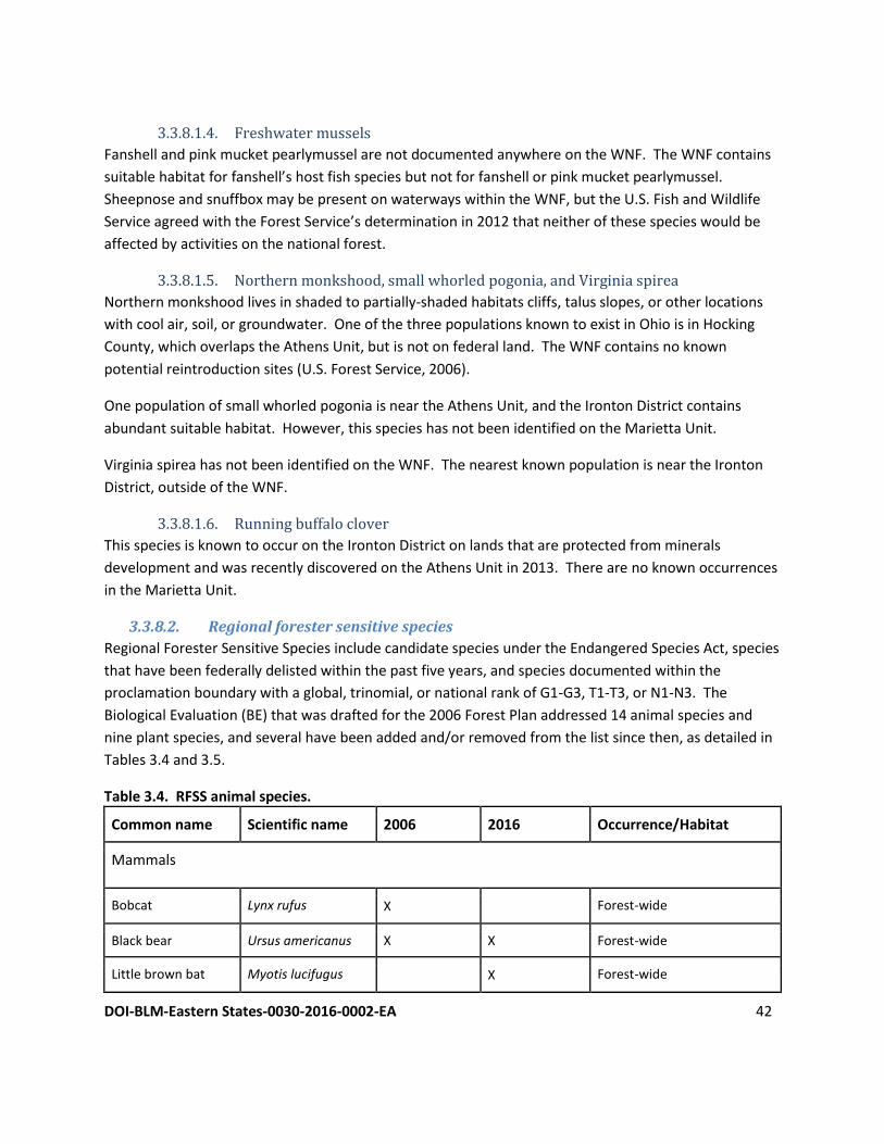
DOI-BLM-Eastern States-0030-2016-0002-EA 42
3.3.8.1.4. Freshwater mussels
Fanshell and pink mucket pearlymussel are not documented anywhere on the WNF. The WNF contains
suitable habitat for fanshell’s host fish species but not for fanshell or pink mucket pearlymussel.
Sheepnose and snuffbox may be present on waterways within the WNF, but the U.S. Fish and Wildlife
Service agreed with the Forest Service’s determination in 2012 that neither of these species would be
affected by activities on the national forest.
3.3.8.1.5. Northern monkshood, small whorled pogonia, and Virginia spirea
Northern monkshood lives in shaded to partially-shaded habitats cliffs, talus slopes, or other locations
with cool air, soil, or groundwater. One of the three populations known to exist in Ohio is in Hocking
County, which overlaps the Athens Unit, but is not on federal land. The WNF contains no known
potential reintroduction sites (U.S. Forest Service, 2006).
One population of small whorled pogonia is near the Athens Unit, and the Ironton District contains
abundant suitable habitat. However, this species has not been identified on the Marietta Unit.
Virginia spirea has not been identified on the WNF. The nearest known population is near the Ironton
District, outside of the WNF.
3.3.8.1.6. Running buffalo clover
This species is known to occur on the Ironton District on lands that are protected from minerals
development and was recently discovered on the Athens Unit in 2013. There are no known occurrences
in the Marietta Unit.
3.3.8.2. Regional forester sensitive species
Regional Forester Sensitive Species include candidate species under the Endangered Species Act, species
that have been federally delisted within the past five years, and species documented within the
proclamation boundary with a global, trinomial, or national rank of G1-G3, T1-T3, or N1-N3. The
Biological Evaluation (BE) that was drafted for the 2006 Forest Plan addressed 14 animal species and
nine plant species, and several have been added and/or removed from the list since then, as detailed in
Tables 3.4 and 3.5.
Table 3.4. RFSS animal species.
Common name Scientific name 2006 2016 Occurrence/Habitat
Mammals
Bobcat Lynx rufus X Forest-wide
Black bear Ursus americanus X X Forest-wide
Little brown bat Myotis lucifugus X Forest-wide
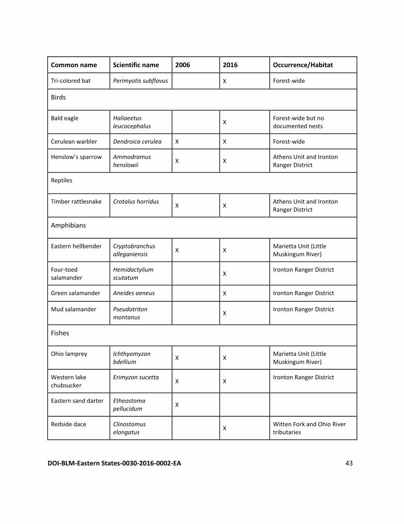
DOI-BLM-Eastern States-0030-2016-0002-EA 43
Common name Scientific name 2006 2016 Occurrence/Habitat
Tri-colored bat Perimyotis subflavus X Forest-wide
Birds
Bald eagle Haliaeetus leucocephalus
X Forest-wide but no documented nests
Cerulean warbler Dendroica cerulea X X Forest-wide
Henslow’s sparrow Ammodramus henslowii
X X Athens Unit and Ironton Ranger District
Reptiles
Timber rattlesnake Crotalus horridus X X
Athens Unit and Ironton Ranger District
Amphibians
Eastern hellbender Cryptobranchus alleganiensis
X X Marietta Unit (Little Muskingum River)
Four-toed salamander
Hemidactylium scutatum
X Ironton Ranger District
Green salamander Aneides aeneus X Ironton Ranger District
Mud salamander Pseudotriton montanus
X Ironton Ranger District
Fishes
Ohio lamprey Ichthyomyzon bdellium
X X Marietta Unit (Little Muskingum River)
Western lake chubsucker
Erimyzon sucetta X X
Ironton Ranger District
Eastern sand darter Etheostoma pellucidum
X
Redside dace Clinostomus elongatus
X Witten Fork and Ohio River tributaries
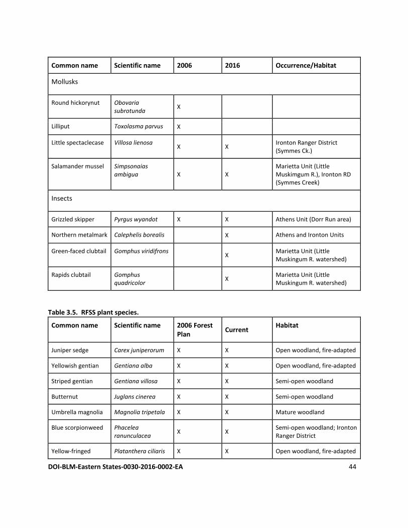
DOI-BLM-Eastern States-0030-2016-0002-EA 44
Common name Scientific name 2006 2016 Occurrence/Habitat
Mollusks
Round hickorynut Obovaria subrotunda
X
Lilliput Toxolasma parvus X
Little spectaclecase Villosa lienosa X X
Ironton Ranger District (Symmes Ck.)
Salamander mussel Simpsonaias ambigua X X
Marietta Unit (Little Muskimgum R.), Ironton RD (Symmes Creek)
Insects
Grizzled skipper Pyrgus wyandot X X Athens Unit (Dorr Run area)
Northern metalmark Calephelis borealis X Athens and Ironton Units
Green-faced clubtail Gomphus viridifrons X
Marietta Unit (Little Muskingum R. watershed)
Rapids clubtail Gomphus quadricolor
X Marietta Unit (Little Muskingum R. watershed)
Table 3.5. RFSS plant species.
Common name Scientific name 2006 Forest Plan
Current Habitat
Juniper sedge Carex juniperorum X X Open woodland, fire-adapted
Yellowish gentian Gentiana alba X X Open woodland, fire-adapted
Striped gentian Gentiana villosa X X Semi-open woodland
Butternut Juglans cinerea X X Semi-open woodland
Umbrella magnolia Magnolia tripetala X X Mature woodland
Blue scorpionweed Phacelea ranunculacea
X X Semi-open woodland; Ironton Ranger District
Yellow-fringed Platanthera ciliaris X X Open woodland, fire-adapted
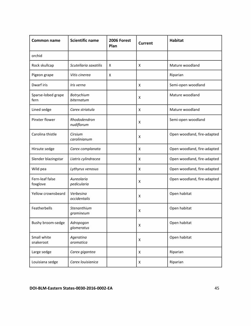
DOI-BLM-Eastern States-0030-2016-0002-EA 45
Common name Scientific name 2006 Forest Plan
Current Habitat
orchid
Rock skullcap Scutellaria saxatilis X X Mature woodland
Pigeon grape Vitis cinerea X Riparian
Dwarf iris Iris verna X Semi-open woodland
Sparse-lobed grape fern
Botrychium biternatum
X Mature woodland
Lined sedge Carex striatula X Mature woodland
Pinxter flower Rhododendron nudiflorum
X Semi-open woodland
Carolina thistle Cirsium carolinianum
X Open woodland, fire-adapted
Hirsute sedge Carex complanata X Open woodland, fire-adapted
Slender blazingstar Liatris cylindracea X Open woodland, fire-adapted
Wild pea Lythyrus venosus X Open woodland, fire-adapted
Fern-leaf false foxglove
Aureolaria pedicularia
X Open woodland, fire-adapted
Yellow crownsbeard Verbesina occidentalis
X Open habitat
Featherbells Stenanthium gramineum
X Open habitat
Bushy broom-sedge Adropogon glomeratus
X Open habitat
Small white snakeroot
Ageratina aromatica
X Open habitat
Large sedge Carex gigantea X Riparian
Louisiana sedge Carex louisianica X Riparian
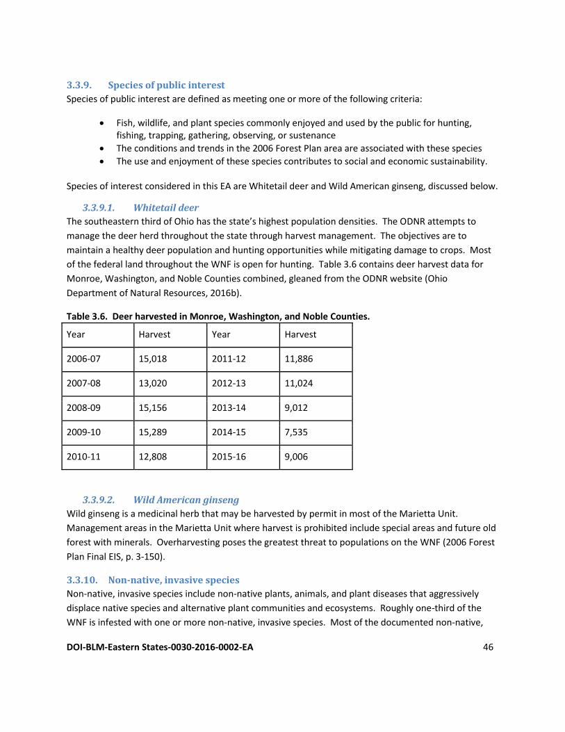
DOI-BLM-Eastern States-0030-2016-0002-EA 46
3.3.9. Species of public interest
Species of public interest are defined as meeting one or more of the following criteria:
Fish, wildlife, and plant species commonly enjoyed and used by the public for hunting, fishing, trapping, gathering, observing, or sustenance
The conditions and trends in the 2006 Forest Plan area are associated with these species
The use and enjoyment of these species contributes to social and economic sustainability. Species of interest considered in this EA are Whitetail deer and Wild American ginseng, discussed below.
3.3.9.1. Whitetail deer
The southeastern third of Ohio has the state’s highest population densities. The ODNR attempts to
manage the deer herd throughout the state through harvest management. The objectives are to
maintain a healthy deer population and hunting opportunities while mitigating damage to crops. Most
of the federal land throughout the WNF is open for hunting. Table 3.6 contains deer harvest data for
Monroe, Washington, and Noble Counties combined, gleaned from the ODNR website (Ohio
Department of Natural Resources, 2016b).
Table 3.6. Deer harvested in Monroe, Washington, and Noble Counties.
Year Harvest Year Harvest
2006-07 15,018 2011-12 11,886
2007-08 13,020 2012-13 11,024
2008-09 15,156 2013-14 9,012
2009-10 15,289 2014-15 7,535
2010-11 12,808 2015-16 9,006
3.3.9.2. Wild American ginseng
Wild ginseng is a medicinal herb that may be harvested by permit in most of the Marietta Unit.
Management areas in the Marietta Unit where harvest is prohibited include special areas and future old
forest with minerals. Overharvesting poses the greatest threat to populations on the WNF (2006 Forest
Plan Final EIS, p. 3-150).
3.3.10. Non-native, invasive species
Non-native, invasive species include non-native plants, animals, and plant diseases that aggressively
displace native species and alternative plant communities and ecosystems. Roughly one-third of the
WNF is infested with one or more non-native, invasive species. Most of the documented non-native,
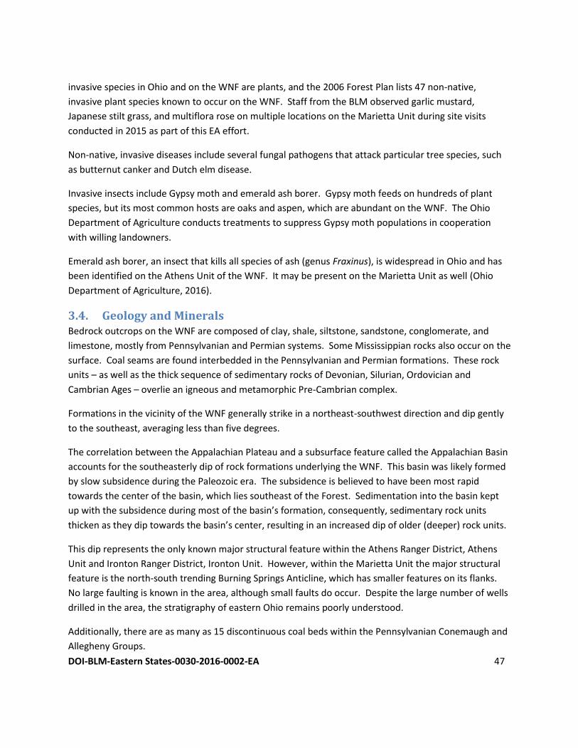
DOI-BLM-Eastern States-0030-2016-0002-EA 47
invasive species in Ohio and on the WNF are plants, and the 2006 Forest Plan lists 47 non-native,
invasive plant species known to occur on the WNF. Staff from the BLM observed garlic mustard,
Japanese stilt grass, and multiflora rose on multiple locations on the Marietta Unit during site visits
conducted in 2015 as part of this EA effort.
Non-native, invasive diseases include several fungal pathogens that attack particular tree species, such
as butternut canker and Dutch elm disease.
Invasive insects include Gypsy moth and emerald ash borer. Gypsy moth feeds on hundreds of plant
species, but its most common hosts are oaks and aspen, which are abundant on the WNF. The Ohio
Department of Agriculture conducts treatments to suppress Gypsy moth populations in cooperation
with willing landowners.
Emerald ash borer, an insect that kills all species of ash (genus Fraxinus), is widespread in Ohio and has
been identified on the Athens Unit of the WNF. It may be present on the Marietta Unit as well (Ohio
Department of Agriculture, 2016).
3.4. Geology and Minerals Bedrock outcrops on the WNF are composed of clay, shale, siltstone, sandstone, conglomerate, and
limestone, mostly from Pennsylvanian and Permian systems. Some Mississippian rocks also occur on the
surface. Coal seams are found interbedded in the Pennsylvanian and Permian formations. These rock
units – as well as the thick sequence of sedimentary rocks of Devonian, Silurian, Ordovician and
Cambrian Ages – overlie an igneous and metamorphic Pre-Cambrian complex.
Formations in the vicinity of the WNF generally strike in a northeast-southwest direction and dip gently
to the southeast, averaging less than five degrees.
The correlation between the Appalachian Plateau and a subsurface feature called the Appalachian Basin
accounts for the southeasterly dip of rock formations underlying the WNF. This basin was likely formed
by slow subsidence during the Paleozoic era. The subsidence is believed to have been most rapid
towards the center of the basin, which lies southeast of the Forest. Sedimentation into the basin kept
up with the subsidence during most of the basin’s formation, consequently, sedimentary rock units
thicken as they dip towards the basin’s center, resulting in an increased dip of older (deeper) rock units.
This dip represents the only known major structural feature within the Athens Ranger District, Athens
Unit and Ironton Ranger District, Ironton Unit. However, within the Marietta Unit the major structural
feature is the north-south trending Burning Springs Anticline, which has smaller features on its flanks.
No large faulting is known in the area, although small faults do occur. Despite the large number of wells
drilled in the area, the stratigraphy of eastern Ohio remains poorly understood.
Additionally, there are as many as 15 discontinuous coal beds within the Pennsylvanian Conemaugh and
Allegheny Groups.
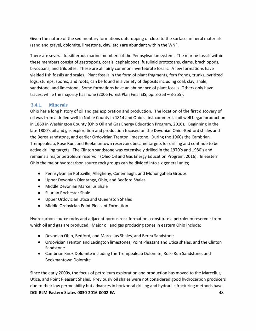
DOI-BLM-Eastern States-0030-2016-0002-EA 48
Given the nature of the sedimentary formations outcropping or close to the surface, mineral materials
(sand and gravel, dolomite, limestone, clay, etc.) are abundant within the WNF.
There are several fossiliferous marine members of the Pennsylvanian system. The marine fossils within
these members consist of gastropods, corals, cephalopods, fusulinid protozoans, clams, brachiopods,
bryozoans, and trilobites. These are all fairly common invertebrate fossils. A few formations have
yielded fish fossils and scales. Plant fossils in the form of plant fragments, fern fronds, trunks, pyritized
logs, stumps, spores, and roots, can be found in a variety of deposits including coal, clay, shale,
sandstone, and limestone. Some formations have an abundance of plant fossils. Others only have
traces, while the majority has none (2006 Forest Plan Final EIS, pp. 3-253 – 3-255).
3.4.1. Minerals
Ohio has a long history of oil and gas exploration and production. The location of the first discovery of
oil was from a drilled well in Noble County in 1814 and Ohio’s first commercial oil well began production
in 1860 in Washington County (Ohio Oil and Gas Energy Education Program, 2016). Beginning in the
late 1800’s oil and gas exploration and production focused on the Devonian Ohio -Bedford shales and
the Berea sandstone, and earlier Ordovician Trenton limestone. During the 1960s the Cambrian
Trempealeau, Rose Run, and Beekmantown reservoirs became targets for drilling and continue to be
active drilling targets. The Clinton sandstone was extensively drilled in the 1970’s and 1980’s and
remains a major petroleum reservoir (Ohio Oil and Gas Energy Education Program, 2016). In eastern
Ohio the major hydrocarbon source rock groups can be divided into six general units;
● Pennsylvanian Pottsville, Allegheny, Conemaugh, and Monongahela Groups
● Upper Devonian Olentangy, Ohio, and Bedford Shales
● Middle Devonian Marcellus Shale
● Silurian Rochester Shale
● Upper Ordovician Utica and Queenston Shales
● Middle Ordovician Point Pleasant Formation
Hydrocarbon source rocks and adjacent porous rock formations constitute a petroleum reservoir from
which oil and gas are produced. Major oil and gas producing zones in eastern Ohio include;
● Devonian Ohio, Bedford, and Marcellus Shales, and Berea Sandstone
● Ordovician Trenton and Lexington limestones, Point Pleasant and Utica shales, and the Clinton Sandstone
● Cambrian Knox Dolomite including the Trempealeau Dolomite, Rose Run Sandstone, and
Beekmantown Dolomite
Since the early 2000s, the focus of petroleum exploration and production has moved to the Marcellus,
Utica, and Point Pleasant Shales. Previously oil shales were not considered good hydrocarbon producers
due to their low permeability but advances in horizontal drilling and hydraulic fracturing methods have
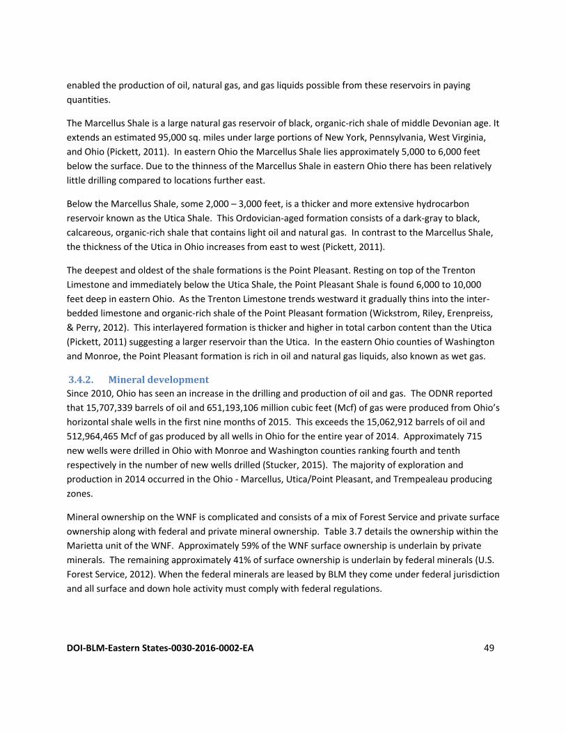
DOI-BLM-Eastern States-0030-2016-0002-EA 49
enabled the production of oil, natural gas, and gas liquids possible from these reservoirs in paying
quantities.
The Marcellus Shale is a large natural gas reservoir of black, organic-rich shale of middle Devonian age. It
extends an estimated 95,000 sq. miles under large portions of New York, Pennsylvania, West Virginia,
and Ohio (Pickett, 2011). In eastern Ohio the Marcellus Shale lies approximately 5,000 to 6,000 feet
below the surface. Due to the thinness of the Marcellus Shale in eastern Ohio there has been relatively
little drilling compared to locations further east.
Below the Marcellus Shale, some 2,000 – 3,000 feet, is a thicker and more extensive hydrocarbon
reservoir known as the Utica Shale. This Ordovician-aged formation consists of a dark-gray to black,
calcareous, organic-rich shale that contains light oil and natural gas. In contrast to the Marcellus Shale,
the thickness of the Utica in Ohio increases from east to west (Pickett, 2011).
The deepest and oldest of the shale formations is the Point Pleasant. Resting on top of the Trenton
Limestone and immediately below the Utica Shale, the Point Pleasant Shale is found 6,000 to 10,000
feet deep in eastern Ohio. As the Trenton Limestone trends westward it gradually thins into the inter-
bedded limestone and organic-rich shale of the Point Pleasant formation (Wickstrom, Riley, Erenpreiss,
& Perry, 2012). This interlayered formation is thicker and higher in total carbon content than the Utica
(Pickett, 2011) suggesting a larger reservoir than the Utica. In the eastern Ohio counties of Washington
and Monroe, the Point Pleasant formation is rich in oil and natural gas liquids, also known as wet gas.
3.4.2. Mineral development
Since 2010, Ohio has seen an increase in the drilling and production of oil and gas. The ODNR reported
that 15,707,339 barrels of oil and 651,193,106 million cubic feet (Mcf) of gas were produced from Ohio’s
horizontal shale wells in the first nine months of 2015. This exceeds the 15,062,912 barrels of oil and
512,964,465 Mcf of gas produced by all wells in Ohio for the entire year of 2014. Approximately 715
new wells were drilled in Ohio with Monroe and Washington counties ranking fourth and tenth
respectively in the number of new wells drilled (Stucker, 2015). The majority of exploration and
production in 2014 occurred in the Ohio - Marcellus, Utica/Point Pleasant, and Trempealeau producing
zones.
Mineral ownership on the WNF is complicated and consists of a mix of Forest Service and private surface
ownership along with federal and private mineral ownership. Table 3.7 details the ownership within the
Marietta unit of the WNF. Approximately 59% of the WNF surface ownership is underlain by private
minerals. The remaining approximately 41% of surface ownership is underlain by federal minerals (U.S.
Forest Service, 2012). When the federal minerals are leased by BLM they come under federal jurisdiction
and all surface and down hole activity must comply with federal regulations.
DOI-BLM-Eastern States-0030-2016-0002-EA 50
Table 3.7. Wayne National Forest surface/mineral ownership (2006 Forest Plan Final EIS, Table 3-62).
Ownership
Marietta Unit
(acres)
Athens Unit
(acres)
Ironton District (acres)
Forest Totals (acres)
Federal Surface
Federal Minerals
100% minerals Unencumbered 100% minerals with deed lease1 Total Federal Minerals
8,507
8,760
17,267
10,382
8,069
18,451
43,491
17,037
60,528
62,380
33,866
96,246
Private Minerals2
Reserved Minerals Outstanding Minerals Combination3 Total Private Minerals
4,384
7,622
34,725
46,731
5,663
12,468
36,565
54,696
9,182
11,000
21,642
41,824
19,229
31,090
92,932
143,251
Total Federal Surface 63,998 73,147 102,352 239,497
Private Surface
Federal Minerals 7 116 708 831
Private Minerals 204,053 195,682 214,273 614,008
Total Private Surface 204,060 195,798 214,981 614,839
Total Acres within the WNF 268,058 268,945 317,333 854,336 1 Most of these leases appear to be inactive and/or may have expired, but their legal status is currently unknown. 2 Reserved, Outstanding, and Combination minerals may not all be 100% private minerals. Partial Federal interests may exist as well. 3 Combination indicates a parcel with two or more outstanding, reserved or deed lease rights.
3.5. Soils The 2006 Forest Plan Final EIS states that the forest is located in Ohio’s Hill Country, consisting of a long
series of narrow ridges and U-shaped valleys. The slopes tend to be benched or segmented with
alternating sections of steep and moderately sloped gradients due to the resistance of different strata to
erosion. Due to the steep gradients and soil textures (surface texture = silt loam, loam, or sandy loam;
subsoil texture = sandy loam to clay) erosion is probable if the duff layer is disturbed.
Soil loss within the Marietta Unit proclamation boundary ranges from up to one-half ton per acre per
year on undisturbed forested lands and to up to seven tons per acre per year on croplands. Soil mass
movement is possible on the steepest areas of the forest, with nearly all valleys containing evidence of
slide areas. Serious erosion is usually limited to road use during excessively wet periods where roads are
poorly located or not engineered for proper drainage or flow, which is usually most likely on
unauthorized roads and trails. Intermingled farms and rural roads, rather than forested land, are the
major sources of soil erosion. Serious soil erosion is common on private forest land due to lack of
appropriate mitigation measures being implemented.
For more detailed information refer to the Soils section of the 2006 Forest Plan Final EIS, pages 3-21.
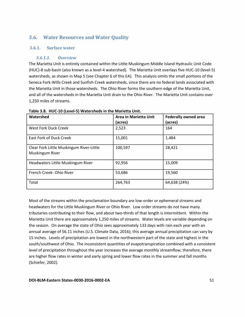
DOI-BLM-Eastern States-0030-2016-0002-EA 51
3.6. Water Resources and Water Quality
3.6.1. Surface water
3.6.1.1. Overview
The Marietta Unit is entirely contained within the Little Muskingum Middle Island Hydraulic Unit Code
(HUC)-8 sub-basin (also known as a level-4 watershed). The Marietta Unit overlays five HUC-10 (level-5)
watersheds, as shown in Map 5 (see Chapter 6 of this EA). This analysis omits the small portions of the
Seneca Fork-Wills Creek and Sunfish Creek watersheds, since there are no federal lands associated with
the Marietta Unit in those watersheds. The Ohio River forms the southern edge of the Marietta Unit,
and all of the watersheds in the Marietta Unit drain to the Ohio River. The Marietta Unit contains over
1,250 miles of streams.
Table 3.8. HUC-10 (Level-5) Watersheds in the Marietta Unit.
Watershed Area in Marietta Unit (acres)
Federally owned area (acres)
West Fork Duck Creek 2,523 164
East Fork of Duck Creek 15,001 1,484
Clear Fork Little Muskingum River-Little Muskingum River
100,597 28,421
Headwaters Little Muskingum River 92,956 15,009
French Creek- Ohio River 53,686 19,560
Total 264,763 64,638 (24%)
Most of the streams within the proclamation boundary are low-order or ephemeral streams and
headwaters for the Little Muskingum River or Ohio River. Low order streams do not have many
tributaries contributing to their flow, and about two-thirds of that length is intermittent. Within the
Marietta Unit there are approximately 1,250 miles of streams. Water levels are variable depending on
the season. On average the state of Ohio sees approximately 133 days with rain each year with an
annual average of 56.11 inches (U.S. Climate Data, 2016); this average annual precipitation can vary by
15 inches. Levels of precipitation are lowest in the northwestern part of the state and highest in the
south/southwest of Ohio. The inconsistent quantities of evapotranspiration combined with a consistent
level of precipitation throughout the year increases the average monthly streamflow; therefore, there
are higher flow rates in winter and early spring and lower flow rates in the summer and fall months
(Schiefer, 2002).
DOI-BLM-Eastern States-0030-2016-0002-EA 52
3.6.1.2. Surface water quality
In 1996 the Forest Service assessed 200 miles of impaired streams within the WNF finding that 11% of
the streams met Ohio’s water quality standards, 48% were impaired, and 41% had not been assessed
yet by the Ohio EPA or Forest Service. The causes of impairment are generally attributed to abandoned
mines and agriculture. In the Marietta Unit, impairment is attributed to nutrients, siltation, pasture land
run-off, agricultural run-off, and on-site wastewater systems.
In 2010, the U.S. EPA conducted an assessment analyzing stream impairment was conducted on the
Little Muskingum-Middle Island Watershed (HUC-12 Watersheds). Of the 36 watersheds (1555 miles of
streams) in the Little Muskingum-Middle Island Watershed, 25 (1245.7 miles) were impaired and the
remaining 9 (309.3 miles) were not assessed. Of the streams that were analyzed in the Little
Muskingum-Middle Island Watershed, 19 are within the Marietta Unit. In the Marietta Unit, 17 of the
streams were impaired and the remaining 2 were not analyzed. The causes of impairment include: flow
alterations (FA), sedimentation or siltation (S), total suspended solids (TSS), total toxics (TT) or unknown
toxicity, organic enrichment/ low dissolved oxygen/ Oxygen Depletion (O), polychlorinated biphenyls
(PCBs), Pesticides/DDT (P), nutrients (N), metals (M), habitat alterations (HA), or other toxicity levels
exceeding Total Maximum Daily Load (TMDL) standards. According to the Clean Water Act (CWA) each
state is required to identify a prioritized list of their Section 303 (d) impaired waters. Each state submits
their TMDLs to the EPA and the TMDLs are either approved or denied. TMDLs are determined by taking
into account the loading capacity of the water body as it relates to different pollutants and what actions
would need to occur in order to control them. TMDLs are significant because they are the link between
causes of impairment and the actions needed to meet water quality standards. Once the causes of
point and non-point pollution or impairment are identified TMDLs for each pollutant are determine. The
probable causes for impairments in the Marietta Unit are non-irrigated crop production, pasture land,
and acid mine drainage (AMD). The reasons for impairment are listed in Table 3.9 as they correspond
with the risks they pose on aquatic life, human health, recreation, or public drinking (United States
Environmental Protection Agency, 2016).
This most recent Ohio Integrated Water Quality Monitoring and Assessment Report was conducted in
2014, also known as the Integrated Report. The Integrated Report satisfies the CWA requirements for
both Section 305 (b) for biennial reports on the state's waters conditions and Section 303 (d) for
prioritized list of impaired waters. Overall it indicates that larger rivers in Ohio are more likely to be in
attainment than smaller streams; that is where most of the non-attainment waterways are found.
There are four major components to the Integrated Report; human health use, recreation use, aquatic
life use, and public drinking water use. Human health evaluation occurs by comparing contaminated
fish tissue to determine fish consumption advisories. Recreation evaluation methodology is a bacterial
water assessment. Aquatic life is evaluated through the use of a biological assessment and a biocriteria
program which measured by using two indices, the Index of Biotic Integrity (IBI) and the Modified Index
of Well-Being (MIwb) for fish and Invertebrate Community Index (ICI) for aquatic macro invertebrates.
Public drinking water conditions are determined by the level of algae and associated cyanotoxins. The
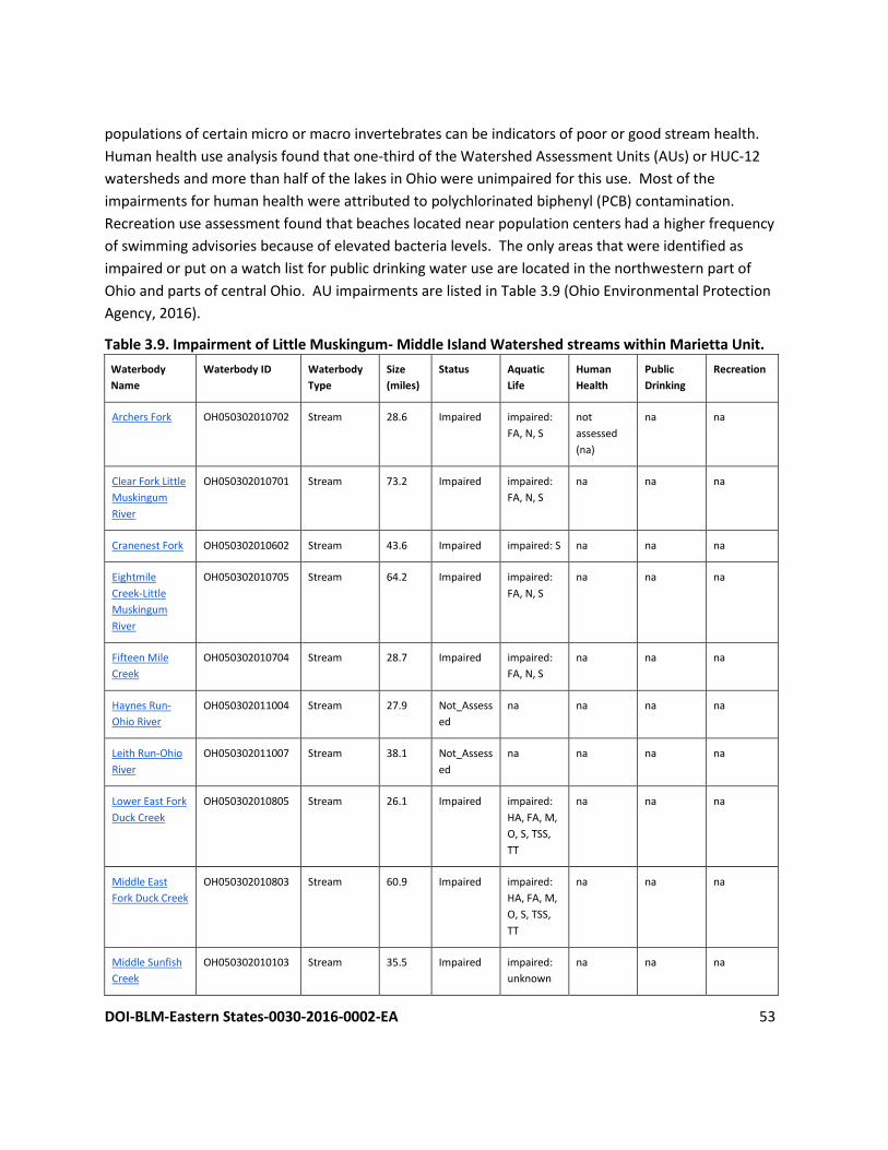
DOI-BLM-Eastern States-0030-2016-0002-EA 53
populations of certain micro or macro invertebrates can be indicators of poor or good stream health.
Human health use analysis found that one-third of the Watershed Assessment Units (AUs) or HUC-12
watersheds and more than half of the lakes in Ohio were unimpaired for this use. Most of the
impairments for human health were attributed to polychlorinated biphenyl (PCB) contamination.
Recreation use assessment found that beaches located near population centers had a higher frequency
of swimming advisories because of elevated bacteria levels. The only areas that were identified as
impaired or put on a watch list for public drinking water use are located in the northwestern part of
Ohio and parts of central Ohio. AU impairments are listed in Table 3.9 (Ohio Environmental Protection
Agency, 2016).
Table 3.9. Impairment of Little Muskingum- Middle Island Watershed streams within Marietta Unit.
Waterbody
Name Waterbody ID Waterbody
Type Size
(miles) Status Aquatic
Life Human
Health Public
Drinking Recreation
Archers Fork OH050302010702 Stream 28.6 Impaired impaired:
FA, N, S not
assessed
(na)
na na
Clear Fork Little
Muskingum
River
OH050302010701 Stream 73.2 Impaired impaired:
FA, N, S na na na
Cranenest Fork OH050302010602 Stream 43.6 Impaired impaired: S na na na
Eightmile
Creek-Little
Muskingum
River
OH050302010705 Stream 64.2 Impaired impaired:
FA, N, S na na na
Fifteen Mile
Creek OH050302010704 Stream 28.7 Impaired impaired:
FA, N, S na na na
Haynes Run-
Ohio River OH050302011004 Stream 27.9 Not_Assess
ed na na na na
Leith Run-Ohio
River OH050302011007 Stream 38.1 Not_Assess
ed na na na na
Lower East Fork
Duck Creek OH050302010805 Stream 26.1 Impaired impaired:
HA, FA, M,
O, S, TSS,
TT
na na na
Middle East
Fork Duck Creek OH050302010803 Stream 60.9 Impaired impaired:
HA, FA, M,
O, S, TSS,
TT
na na na
Middle Sunfish
Creek OH050302010103 Stream 35.5 Impaired impaired:
unknown na na na
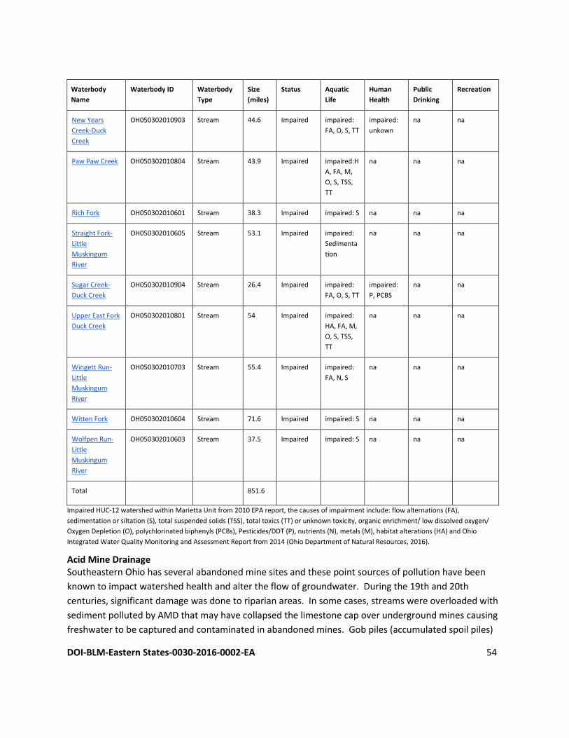
DOI-BLM-Eastern States-0030-2016-0002-EA 54
Waterbody
Name Waterbody ID Waterbody
Type Size
(miles) Status Aquatic
Life Human
Health Public
Drinking Recreation
New Years
Creek-Duck
Creek
OH050302010903 Stream 44.6 Impaired impaired:
FA, O, S, TT impaired:
unkown na na
Paw Paw Creek OH050302010804 Stream 43.9 Impaired impaired:H
A, FA, M,
O, S, TSS,
TT
na na na
Rich Fork OH050302010601 Stream 38.3 Impaired impaired: S na na na
Straight Fork-
Little
Muskingum
River
OH050302010605 Stream 53.1 Impaired impaired:
Sedimenta
tion
na na na
Sugar Creek-
Duck Creek OH050302010904 Stream 26.4 Impaired impaired:
FA, O, S, TT impaired:
P, PCBS na na
Upper East Fork
Duck Creek OH050302010801 Stream 54 Impaired impaired:
HA, FA, M,
O, S, TSS,
TT
na na na
Wingett Run-
Little
Muskingum
River
OH050302010703 Stream 55.4 Impaired impaired:
FA, N, S na na na
Witten Fork OH050302010604 Stream 71.6 Impaired impaired: S na na na
Wolfpen Run-
Little
Muskingum
River
OH050302010603 Stream 37.5 Impaired impaired: S na na na
Total 851.6
Impaired HUC-12 watershed within Marietta Unit from 2010 EPA report, the causes of impairment include: flow alternations (FA),
sedimentation or siltation (S), total suspended solids (TSS), total toxics (TT) or unknown toxicity, organic enrichment/ low dissolved oxygen/
Oxygen Depletion (O), polychlorinated biphenyls (PCBs), Pesticides/DDT (P), nutrients (N), metals (M), habitat alterations (HA) and Ohio
Integrated Water Quality Monitoring and Assessment Report from 2014 (Ohio Department of Natural Resources, 2016).
Acid Mine Drainage Southeastern Ohio has several abandoned mine sites and these point sources of pollution have been
known to impact watershed health and alter the flow of groundwater. During the 19th and 20th
centuries, significant damage was done to riparian areas. In some cases, streams were overloaded with
sediment polluted by AMD that may have collapsed the limestone cap over underground mines causing
freshwater to be captured and contaminated in abandoned mines. Gob piles (accumulated spoil piles)
DOI-BLM-Eastern States-0030-2016-0002-EA 55
contaminated the water and surrounding areas, and the natural landscape was altered by strip-mining
(2006 Forest Plan Final EIS, pp. 3-6 & 3-7). In 1972, Ohio statutes began to require restoration of
desirable environment that had been disturbed by mining. Prior to these reclamation standards, Ohio
was left with 1,300 miles of AMD-polluted streams, 500 miles of streams affected by sediment
deposition, and polluted domestic water supplies. In March 1995, the ODNR established the Acid Mine
Drainage Abatement and Treatment (AMDAT) fund to aid in long-term cleanup of AMD problems. This
program addresses source control and then treatment which can be active or passive (Ohio Department
of Natural Resources, 2015a). The way AMD is addressed is continuously evolving. An example of active
treatment would be using chemical treatment systems and an example of passive treatment would be
allowing natural occurring chemical or biological processes to aid in AMD treatment. In 1977, the
federal government passed the Surface Mining Control Reclamation Act in recognition of all the
abandoned mines, and then created the federal Abandoned Mine Land (AML) Program. The results of
this program up until 2014 include a total of more than 10,000 acres of reclaimed lands in Ohio that
were impacted by the 200 years of coal mining in Ohio. Through 2014, the AML Program has also
replaced 339 supplies of polluted residential water supplies, completing 94.7% of the completed current
inventory (Ohio Department of Natural Resources, 2016a).
3.6.2. Groundwater
3.6.2.1. Groundwater quantity
Nearly all rural populations in Ohio obtain drinking water from groundwater sources (USGS). There are
888 drinking water wells within the Marietta Unit proclamation boundary (Ohio Department of Natural
Resources, 2015b and 2015c). Their static water levels range from zero feet below surface to 183 feet
below surface with a mean of 32 feet. The mean depth of drinking water wells in the Marietta Unit is 86
feet, with a maximum depth of 475 feet. Most of these wells have a yield of less than ten gallons per
minute. The higher-yielding wells are located in the floodplains of the Ohio River and Little Muskingum
River.
3.6.2.2. Groundwater quality
Groundwater under the Marietta Unit flows largely through fractures in bedrock (Thompson, 2012).
These fractures are most abundant near the surface, and at depths of a few hundred feet, the relative
absence of fractures prevents groundwater from flowing and allows it to dissolve minerals from the
bedrock, producing brackish water. The potable groundwater under the Marietta Unit is largely free of
contaminants at levels above human health standards (Ohio Environmental Protection Agency, 2012).
There are sites in Washington County with elevated nitrates, and Washington County has two sanitary
landfills that are sources of groundwater contamination. Groundwater pollution potential is highest in
the riparian areas, most likely because of the short depth to groundwater in those areas (Ohio
Department of Natural Resources, 2002).
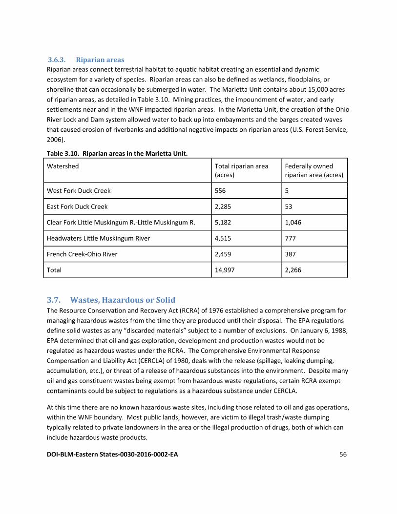
DOI-BLM-Eastern States-0030-2016-0002-EA 56
3.6.3. Riparian areas
Riparian areas connect terrestrial habitat to aquatic habitat creating an essential and dynamic
ecosystem for a variety of species. Riparian areas can also be defined as wetlands, floodplains, or
shoreline that can occasionally be submerged in water. The Marietta Unit contains about 15,000 acres
of riparian areas, as detailed in Table 3.10. Mining practices, the impoundment of water, and early
settlements near and in the WNF impacted riparian areas. In the Marietta Unit, the creation of the Ohio
River Lock and Dam system allowed water to back up into embayments and the barges created waves
that caused erosion of riverbanks and additional negative impacts on riparian areas (U.S. Forest Service,
2006).
Table 3.10. Riparian areas in the Marietta Unit.
Watershed Total riparian area (acres)
Federally owned riparian area (acres)
West Fork Duck Creek 556 5
East Fork Duck Creek 2,285 53
Clear Fork Little Muskingum R.-Little Muskingum R. 5,182 1,046
Headwaters Little Muskingum River 4,515 777
French Creek-Ohio River 2,459 387
Total 14,997 2,266
3.7. Wastes, Hazardous or Solid The Resource Conservation and Recovery Act (RCRA) of 1976 established a comprehensive program for
managing hazardous wastes from the time they are produced until their disposal. The EPA regulations
define solid wastes as any “discarded materials” subject to a number of exclusions. On January 6, 1988,
EPA determined that oil and gas exploration, development and production wastes would not be
regulated as hazardous wastes under the RCRA. The Comprehensive Environmental Response
Compensation and Liability Act (CERCLA) of 1980, deals with the release (spillage, leaking dumping,
accumulation, etc.), or threat of a release of hazardous substances into the environment. Despite many
oil and gas constituent wastes being exempt from hazardous waste regulations, certain RCRA exempt
contaminants could be subject to regulations as a hazardous substance under CERCLA.
At this time there are no known hazardous waste sites, including those related to oil and gas operations,
within the WNF boundary. Most public lands, however, are victim to illegal trash/waste dumping
typically related to private landowners in the area or the illegal production of drugs, both of which can
include hazardous waste products.
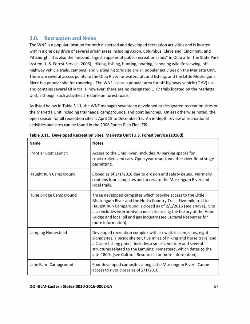
DOI-BLM-Eastern States-0030-2016-0002-EA 57
3.8. Recreation and Noise The WNF is a popular location for both dispersed and developed recreation activities and is located
within a one day drive of several urban areas including Akron, Columbus, Cleveland, Cincinnati, and
Pittsburgh. It is also the “second largest supplier of public recreation lands” in Ohio after the State Park
system (U.S. Forest Service, 2006). Hiking, fishing, hunting, boating, canoeing wildlife viewing, off-
highway vehicle trails, camping, and visiting historic site are all popular activities on the Marietta Unit.
There are several access points to the Ohio River for watercraft and fishing, and the Little Muskingum
River is a popular site for canoeing. The WNF is also a popular area for off-highway vehicle (OHV) use
and contains several OHV trails; however, there are no designated OHV trails located on the Marietta
Unit, although such activities are done on forest roads.
As listed below in Table 3.11, the WNF manages seventeen developed or designated recreation sites on
the Marietta Unit including trailheads, campgrounds, and boat launches. Unless otherwise noted, the
open season for all recreation sites is April 15 to December 15. An in-depth review of recreational
activities and sites can be found in the 2006 Forest Plan Final EIS.
Table 3.11. Developed Recreation Sites, Marietta Unit (U.S. Forest Service (2016d).
Name Notes
Frontier Boat Launch Access to the Ohio River. Includes 70 parking spaces for truck/trailers and cars. Open year round, weather river flood stage permitting.
Haught Run Campground Closed as of 2/1/2016 due to erosion and safety issues. Normally contains four campsites and access to the Muskingum River and local trails.
Hune Bridge Campground Three developed campsites which provide access to the Little Muskingum River and the North Country Trail. Five-mile trail to Haught Run Campground is closed as of 2/1/2016 (see above). Site also includes interpretive panels discussing the history of the Hune Bridge and local oil and gas industry (see Cultural Resources for more information).
Lamping Homestead Developed recreation complex with six walk-in campsites, eight picnic sites, a picnic shelter, five miles of hiking and horse trails, and a 2-acre fishing pond. Includes a small cemetery and several structures related to the Lamping Homestead, which dates to the late-1800s (see Cultural Resources for more information).
Lane Farm Campground Four developed campsites along Little Muskingum River. Canoe access to river closes as of 2/1/2016.
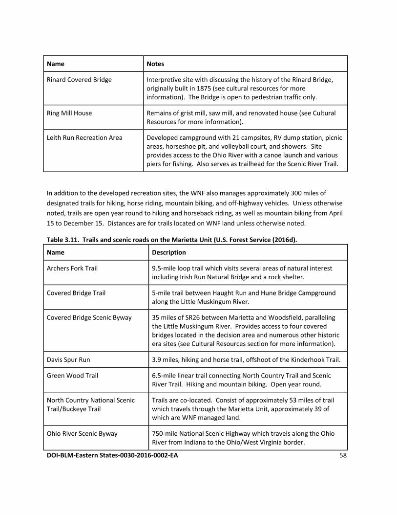
DOI-BLM-Eastern States-0030-2016-0002-EA 58
Name Notes
Rinard Covered Bridge Interpretive site with discussing the history of the Rinard Bridge, originally built in 1875 (see cultural resources for more information). The Bridge is open to pedestrian traffic only.
Ring Mill House Remains of grist mill, saw mill, and renovated house (see Cultural Resources for more information).
Leith Run Recreation Area Developed campground with 21 campsites, RV dump station, picnic areas, horseshoe pit, and volleyball court, and showers. Site provides access to the Ohio River with a canoe launch and various piers for fishing. Also serves as trailhead for the Scenic River Trail.
In addition to the developed recreation sites, the WNF also manages approximately 300 miles of
designated trails for hiking, horse riding, mountain biking, and off-highway vehicles. Unless otherwise
noted, trails are open year round to hiking and horseback riding, as well as mountain biking from April
15 to December 15. Distances are for trails located on WNF land unless otherwise noted.
Table 3.11. Trails and scenic roads on the Marietta Unit (U.S. Forest Service (2016d).
Name Description
Archers Fork Trail 9.5-mile loop trail which visits several areas of natural interest including Irish Run Natural Bridge and a rock shelter.
Covered Bridge Trail 5-mile trail between Haught Run and Hune Bridge Campground along the Little Muskingum River.
Covered Bridge Scenic Byway 35 miles of SR26 between Marietta and Woodsfield, paralleling the Little Muskingum River. Provides access to four covered bridges located in the decision area and numerous other historic era sites (see Cultural Resources section for more information).
Davis Spur Run 3.9 miles, hiking and horse trail, offshoot of the Kinderhook Trail.
Green Wood Trail 6.5-mile linear trail connecting North Country Trail and Scenic River Trail. Hiking and mountain biking. Open year round.
North Country National Scenic Trail/Buckeye Trail
Trails are co-located. Consist of approximately 53 miles of trail which travels through the Marietta Unit, approximately 39 of which are WNF managed land.
Ohio River Scenic Byway 750-mile National Scenic Highway which travels along the Ohio River from Indiana to the Ohio/West Virginia border.
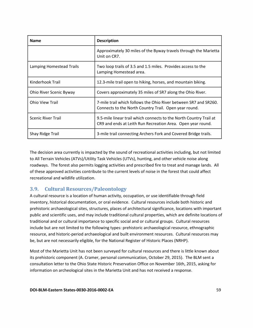
DOI-BLM-Eastern States-0030-2016-0002-EA 59
Name Description
Approximately 30 miles of the Byway travels through the Marietta Unit on CR7.
Lamping Homestead Trails Two loop trails of 3.5 and 1.5 miles. Provides access to the Lamping Homestead area.
Kinderhook Trail 12.3-mile trail open to hiking, horses, and mountain biking.
Ohio River Scenic Byway Covers approximately 35 miles of SR7 along the Ohio River.
Ohio View Trail 7-mile trail which follows the Ohio River between SR7 and SR260. Connects to the North Country Trail. Open year round.
Scenic River Trail 9.5-mile linear trail which connects to the North Country Trail at CR9 and ends at Leith Run Recreation Area. Open year round.
Shay Ridge Trail 3-mile trail connecting Archers Fork and Covered Bridge trails.
The decision area currently is impacted by the sound of recreational activities including, but not limited
to All Terrain Vehicles (ATVs)/Utility Task Vehicles (UTVs), hunting, and other vehicle noise along
roadways. The forest also permits logging activities and prescribed fire to treat and manage lands. All
of these approved activities contribute to the current levels of noise in the forest that could affect
recreational and wildlife utilization.
3.9. Cultural Resources/Paleontology A cultural resource is a location of human activity, occupation, or use identifiable through field
inventory, historical documentation, or oral evidence. Cultural resources include both historic and
prehistoric archaeological sites, structures, places of architectural significance, locations with important
public and scientific uses, and may include traditional cultural properties, which are definite locations of
traditional and or cultural importance to specific social and or cultural groups. Cultural resources
include but are not limited to the following types: prehistoric archaeological resource, ethnographic
resource, and historic-period archaeological and built environment resources. Cultural resources may
be, but are not necessarily eligible, for the National Register of Historic Places (NRHP).
Most of the Marietta Unit has not been surveyed for cultural resources and there is little known about
its prehistoric component (A. Cramer, personal communication, October 29, 2015). The BLM sent a
consultation letter to the Ohio State Historic Preservation Office on November 16th, 2015, asking for
information on archeological sites in the Marietta Unit and has not received a response.
DOI-BLM-Eastern States-0030-2016-0002-EA 60
The Ohio River Valley is known for its history dating to the early European exploration and settlement in
the 1600s. During the 1700s and early 1800s, southeastern Ohio saw the most intensive settlement in
what was then called the Northwest Territory because of its proximity to Pennsylvania and Virginia, with
Marietta becoming the first major town in the region (Arbogast, 2004). The majority of the land in the
Marietta Unit was subjected to farming and logging. The Forest Service began to acquire such land in
1935 with official boundaries being determined in 1951. Until 1993, the WNF was managed as a section
of the Wayne-Hoosier National Forest until official separation in 1993 (Arbogast, 2004).
Most of the known historic era resources in the Marietta Unit consist of covered bridges and the
remains of homesteads and farms. Most of the land of the Covered Bridge Scenic Byway allows access
to four covered bridges and several historic locations located along the Little Muskingum River in the
decision area. Several of these sites are listed in the NHRP, including the Rinard Bridge, originally built in
1879 (Buonopane, Ebright, & Smith, 2012). The Hills Covered Bridge, built in 1878, contains an
interpretive display discussing the history of the bridge and its Howe Truss design (U.S. Forest Service,
2015). Hune Bridge, built in 1877 and listed in the NHRP, is the only covered bridge on the byway still
open to traffic and allows access to the Hune Campground. The campground contains interpretive
panels discussing the history of the bridge and the local oil and gas industry; part of this display includes
an active tank which collects oil from nearby wells and an interpretive panel discussing the process and
history of the oil and gas industry in the region (U.S. Forest Service, 2016a). The Walter Ring House,
originally constructed in the 1850s and also listed in the NHRP, includes interpretative panels discussing
its prior use as a grist mill and sawmill (U.S. Forest Service, 2016e).
Other sites accessed by the Covered Bridge Scenic Byway include the Lamping Homestead. The Lamping
Homestead contains the remains of several buildings constructed by the Lamping family during the
1800s as well as the family cemetery (Reed, 2014). The Lane Farm Campground is located at the former
site of the Lane Family Farm, of which there are little remnants except a walnut plantation (U.S. Forest
Service, 2016b).
Paleontology There are no known paleontology localities within the Marietta Unit.
3.10. Native American Religious Concerns The BLM sent letters to seven Federally Recognized Tribes who have a known connection to the area on
November 6, 2015, asking to identify any concerns which would need special consideration with respect
to the Proposed Action (see Section 1.7.2 for list of Tribes). The BLM has received no responses to date.
3.11. Visual Resources and Scenic Quality Visitors to the WNF are not only attracted to the area for the many recreational opportunities it offers,
but also to enjoy the natural scenic beauty of its landscape. Most of the land that became the WNF
consisted of land cleared for timber, agricultural use, or mined for coal and other minerals. During the
Great Depression in the 1930s, much of the land was abandoned and reverted back to the federal
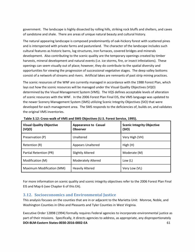
DOI-BLM-Eastern States-0030-2016-0002-EA 61
government. The landscape is highly dissected by rolling hills, striking rock bluffs and shelters, and caves
of sandstone and shale. There are areas of unique natural beauty and cultural history.
The natural appearing landscape is composed predominantly of oak-hickory forest with scattered pines
and is interspersed with private farms and pastureland. The character of the landscape includes such
cultural features as historic barns, log structures, iron furnaces, covered bridges and minerals
development. Also contributing to the scenic quality are the temporary openings created by timber
harvests, mineral development and natural events (i.e. ice storms, fire, or insect infestations). These
openings can seem visually out of place; however, they do contribute to the spatial diversity and
opportunities for viewing the progression of successional vegetative stages. The deep valley bottoms
consist of a network of streams and rivers. Artificial lakes are remnants of past strip mining practices.
The scenic resources of the WNF are currently managed in accordance with the 1988 Forest Plan, which
lays out how the scenic resources will be managed under the Visual Quality Objectives (VQO)
determined by the Visual Management System (VMS). The VQS defines acceptable levels of alteration
of scenic resources with the WNF. In the 2006 Forest Plan Final EIS, the VMS language was updated to
the newer Scenery Management System (SMS) utilizing Scenic Integrity Objectives (SIO) that were
developed for each management area. The SMS responds to the deficiencies of, builds on, and validates
the original VMS inventories.
Table 3.12: Cross-walk of VMS and SMS Objectives (U.S. Forest Service, 1995).
Visual Quality Objective (VQO)
Appearance to Casual Observer
Scenic Integrity Objective (SIO)
Preservation (P) Unaltered Very High (VH)
Retention (R) Appears Unaltered High (H)
Partial Retention (PR) Slightly Altered Moderate (M)
Modification (M) Moderately Altered Low (L)
Maximum Modification (MM) Heavily Altered Very Low (VL)
For more information on scenic quality and scenic integrity objectives refer to the 2006 Forest Plan Final
EIS and Map 6 (see Chapter 6 of this EA).
3.12. Socioeconomics and Environmental Justice This analysis focuses on the counties that are in or adjacent to the Marietta Unit: Monroe, Noble, and
Washington Counties in Ohio and Pleasants and Tyler Counties in West Virginia.
Executive Order 12898 (1994) formally requires Federal agencies to incorporate environmental justice as
part of their missions. Specifically, it directs agencies to address, as appropriate, any disproportionately
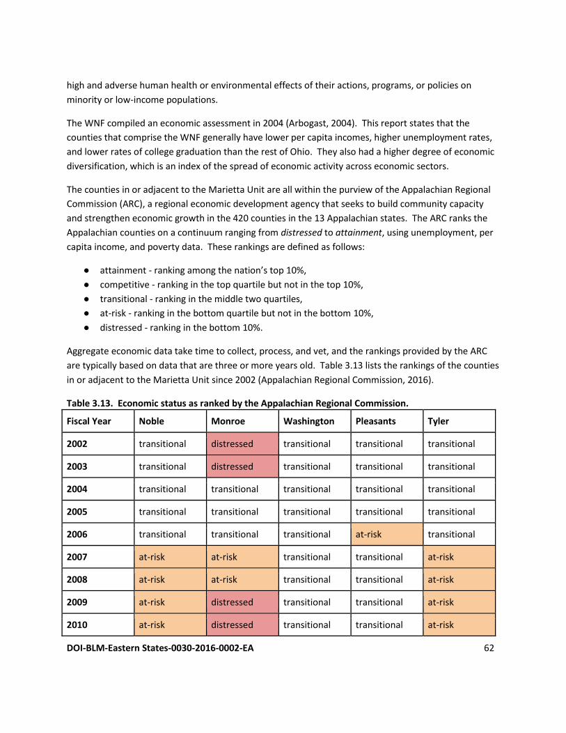
DOI-BLM-Eastern States-0030-2016-0002-EA 62
high and adverse human health or environmental effects of their actions, programs, or policies on
minority or low-income populations.
The WNF compiled an economic assessment in 2004 (Arbogast, 2004). This report states that the
counties that comprise the WNF generally have lower per capita incomes, higher unemployment rates,
and lower rates of college graduation than the rest of Ohio. They also had a higher degree of economic
diversification, which is an index of the spread of economic activity across economic sectors.
The counties in or adjacent to the Marietta Unit are all within the purview of the Appalachian Regional
Commission (ARC), a regional economic development agency that seeks to build community capacity
and strengthen economic growth in the 420 counties in the 13 Appalachian states. The ARC ranks the
Appalachian counties on a continuum ranging from distressed to attainment, using unemployment, per
capita income, and poverty data. These rankings are defined as follows:
● attainment - ranking among the nation’s top 10%,
● competitive - ranking in the top quartile but not in the top 10%,
● transitional - ranking in the middle two quartiles,
● at-risk - ranking in the bottom quartile but not in the bottom 10%,
● distressed - ranking in the bottom 10%.
Aggregate economic data take time to collect, process, and vet, and the rankings provided by the ARC
are typically based on data that are three or more years old. Table 3.13 lists the rankings of the counties
in or adjacent to the Marietta Unit since 2002 (Appalachian Regional Commission, 2016).
Table 3.13. Economic status as ranked by the Appalachian Regional Commission.
Fiscal Year Noble Monroe Washington Pleasants Tyler
2002 transitional distressed transitional transitional transitional
2003 transitional distressed transitional transitional transitional
2004 transitional transitional transitional transitional transitional
2005 transitional transitional transitional transitional transitional
2006 transitional transitional transitional at-risk transitional
2007 at-risk at-risk transitional transitional at-risk
2008 at-risk at-risk transitional transitional at-risk
2009 at-risk distressed transitional transitional at-risk
2010 at-risk distressed transitional transitional at-risk
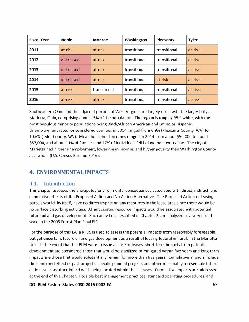
DOI-BLM-Eastern States-0030-2016-0002-EA 63
Fiscal Year Noble Monroe Washington Pleasants Tyler
2011 at-risk at-risk transitional transitional at-risk
2012 distressed at-risk transitional transitional at-risk
2013 distressed at-risk transitional transitional at-risk
2014 distressed at-risk transitional at-risk at-risk
2015 at-risk transitional transitional transitional at-risk
2016 at-risk at-risk transitional transitional at-risk
Southeastern Ohio and the adjacent portion of West Virginia are largely rural, with the largest city,
Marietta, Ohio, comprising about 15% of the population. The region is roughly 95% white, with the
most populous minority populations being Black/African American and Latino or Hispanic.
Unemployment rates for considered counties in 2014 ranged from 6.9% (Pleasants County, WV) to
10.6% (Tyler County, WV). Mean household incomes ranged in 2014 from about $50,000 to about
$57,000, and about 11% of families and 17% of individuals fell below the poverty line. The city of
Marietta had higher unemployment, lower mean income, and higher poverty than Washington County
as a whole (U.S. Census Bureau, 2016).
4. ENVIRONMENTAL IMPACTS
4.1. Introduction This chapter assesses the anticipated environmental consequences associated with direct, indirect, and
cumulative effects of the Proposed Action and No Action Alternative. The Proposed Action of leasing
parcels would, by itself, have no direct impact on any resources in the lease area since there would be
no surface disturbing activities. All anticipated resource impacts would be associated with potential
future oil and gas development. Such activities, described in Chapter 2, are analyzed at a very broad
scale in the 2006 Forest Plan Final EIS.
For the purpose of this EA, a RFDS is used to assess the potential impacts from reasonably foreseeable,
but yet uncertain, future oil and gas development as a result of leasing federal minerals in the Marietta
Unit. In the event that the BLM were to issue a lease or leases, short-term impacts from potential
development are considered those that would be stabilized or mitigated within five years and long-term
impacts are those that would substantially remain for more than five years. Cumulative impacts include
the combined effect of past projects, specific planned projects and other reasonably foreseeable future
actions such as other infield wells being located within these leases. Cumulative impacts are addressed
at the end of this Chapter. Possible best management practices, standard operating procedures, and
DOI-BLM-Eastern States-0030-2016-0002-EA 64
mitigation measures that could be implemented are also discussed within the context of each resource
section below.
4.2. Air Resources
4.2.1. Air quality
An MOU between the U.S. Departments of the Interior and Agriculture and EPA (U.S. Department of
Agriculture, U.S. Department of Interior, and U.S. Environmental Protection Agency, 2011) directs that
air quality modeling be conducted for actions that meet certain emissions or geographic criteria:
● Creation of a substantial increase in emissions ● Material contribution to potential adverse cumulative air quality impacts ● Class I or sensitive Class II Areas ● Non-attainment or maintenance area ● Area expected to exceed NAAQS or PSD increment
While the act of leasing the parcels would produce no substantial air quality effects, potential future
development of the lease could lead to increases in area and regional emissions. Since it is unknown if
the parcels would be developed, or the extent of the development, it is not possible to reasonably
quantify potential air quality effects through dispersion modeling or another applicable method at this
time. Further, the timing, construction and production equipment specifications and configurations,
and specific locations of activities are also unforeseeable at this time. Additional air effects will be
addressed in a subsequent analysis when lessees file an APD. All proposed activities including, but not
limited to, exploratory drilling activities would be subject to applicable local, State, and Federal air
quality laws and regulations.
The following sources of emissions are anticipated during oil and gas exploration or development:
● combustion engines (i.e. fossil fuel fired internal combustion engines used to supply electrical or
hydraulic power for hydraulic fracturing to drive the pumps and rigs used to drill the well, drill
out the hydraulic stage plugs and run the production tubing in the well;
● electric generators to power drill rig engines, pumps, and other equipment;
● compressors used to increase the pressure of the oil or gas for transport and use;
● tailpipe emissions from vehicles transporting equipment to the site);
● venting (i.e. fuel storage tanks vents and pressure control equipment);
● mobile emissions (i.e. vehicles bringing equipment, personnel, or supplies to the location); and
● fugitive sources (i.e. pneumatic valves, tank leaks, and dust).
A number of pollutants associated with combustion of fossil fuels are anticipated to be released during
future drilling activities including: CO, NOx, SO2, Pb, PM, CO2, CH4, and N2O. Venting may release
VOC/HAP, H2S, and CH4. Mobile source emissions are likely to include fugitive particulate matter from
dust and NOx associated with vehicle engine combustion, traffic and/or construction activities.
DOI-BLM-Eastern States-0030-2016-0002-EA 65
The actual emissions of each pollutant are dependent on the factors described in the previous
paragraph. During the completion phase, the most significant emissions of criteria pollutants emitted by
oil and gas operations in general are VOCs, particulate matter and NO2. VOCs and NOx contribute to the
formation of ozone. The EPA’s Natural Gas STAR Program (2014) is a voluntary program that identifies
sources of fugitive methane sources and seeks to minimize fugitive CH4 through careful tuning of
existing equipment and technology upgrades. Data provided by STAR show that some of the largest air
emissions in the natural gas industry occur as natural gas wells are fractured and are being prepared for
production. During well completion, flowback, fracturing fluids, water, and reservoir gas come to the
surface at high velocity and volume. This mixture includes a high volume of VOCs and CH4, along with air
toxins such as benzene, ethylbenzene, and n-hexane. The typical flowback process lasts from three to
ten days. Additional emissions from other processes and equipment during production and
transportation of the oil and gas from the well to a processing facility may occur.
To reasonably quantify emissions associated with well exploration and production activities, certain
types of information are needed. Such information includes a combination of activity data such as:
● The number, type, and duration of equipment needed to construct/reclaim, drill and complete (e.g., belly scrapers, rig, completions, supply trucks, compressor, and production facilities)
● The technologies which may be employed by a given company for drilling any new wells to reduce emissions (e.g. Selective Catalytic Reduction (SCR) on diesel powered drill rigs, natural gas fired drill rig engines, the use of “green” completion technology, and multi-stage flare stacks)
● Area of disturbance for each type of activity (e.g. roads, pads, pipelines, electrical lines, and compressor station)
● Compression per well (sales and field booster), or average horsepower for each type of compressor, if needed
● The number and type of facilities utilized for production operations.
The degree of impact will also vary according to the characteristics of the geological formations from
which production occurs but emissions associated with oil and gas operations would incrementally
contribute to increases in air quality emissions into the atmosphere.
Air pollution can affect public health in many ways. Numerous scientific studies have linked air pollution
to a variety of health problems including: (1) respiratory and cardiovascular disease, (2) decreased lung
function, (3) increased frequency and severity of respiratory symptoms such as difficulty breathing and
coughing, (4) increased susceptibility to respiratory infections, (5) effects on the nervous system,
including the brain, such as IQ loss and impacts on learning, memory, and behavior, (6) cancer, and (7)
premature death. Sensitive individuals or those at high risk appear to be at even greater risk for air
pollution-related health effects, for example, those with pre-existing heart and lung diseases (e.g., heart
failure/ischemic heart disease, asthma, emphysema, and chronic bronchitis), diabetics, older adults, and
DOI-BLM-Eastern States-0030-2016-0002-EA 66
children. Operations that would violate a state and/or federal air quality standard would not be
approved.
Degradation of air quality may also damage ecosystem resources. For example, ozone can damage
vegetation, adversely impacting the growth of plants and trees. These impacts can reduce the ability of
plants to uptake CO2 from the atmosphere and can then indirectly affect the larger ecosystems.
4.2.2 Visibility
Section 169A of the CAA requires the examination of certain categories of air pollution sources on
atmospheric clarity in downwind National Park or wilderness areas (Implemented in 64 FR35714 and
70FR39104) using Guidelines for Best Available Retrofit Technology (BART). An air pollution source
meeting the specific criteria are considered BART-eligible. The Ohio EPA published a report on BART-
eligible sources and impacts in 2011, which were all in adjacent states (Ohio Environmental Protection
Agency, 2011). Twelve facilities were found to need more analysis for potential impacts to 17 total Class
1 Areas. Impacts for all but one coal combustion facility fell well below the eight days/year exceedance
levels for Sulfur Dioxide, Nitrous Oxide, and particulate matter. Sulfur Dioxide was the only contributing
factor to two Class 1 areas after a zero out test, and the facility was put on a five-year reduction permit
to eliminate 90% of the emissions.
Potential reasonably foreseeable oil and gas activities would only contribute short-term and negligible
amounts to local visibility, and would not impact any Class 1 or Sensitive Class 2 areas in adjacent states.
4.2.3 Possible Future Best Management Practices, Standard Operating Procedures, and/or
Mitigation Measures
The BLM encourages industry to incorporate and implement Best Management Practices (BMPs)
designed to reduce impacts to air quality by reducing emissions, surface disturbances, and dust from
field production and operations. Typical measures include:
● Flared hydrocarbon gases at high temperatures in order to reduce emissions of incomplete combustion.
● Watering dirt roads during periods of high use to reduce fugitive dust emissions. ● Co-location wells and production facilities to reduce new surface disturbance. ● Implementation of directional drilling and horizontal completion technologies whereby one well
provides access to petroleum resources that would normally require the drilling of several vertical wellbores.
● Requiring that vapor recovery systems be maintained and functional in areas where petroleum liquids are stored.
● Performing interim reclamation to reclaim areas of the pad not required for production facilities and to reduce the amount of dust from the pads.
Additionally, the BLM encourages oil and natural gas companies to adopt proven, cost-effective
technologies and practices that improve operational efficiency and reduce natural gas emissions.
DOI-BLM-Eastern States-0030-2016-0002-EA 67
In October 2012, EPA promulgated air quality regulations for completion of hydraulically fractured gas
wells (U.S. Environmental Protection Agency, 2015b). These rules require air pollution mitigation
measures that reduce the emissions of volatile organic compounds during gas well completions.
Mitigation includes utilizing a process known as a “green” completion in which natural gas brought up
during flowback is captured in tanks rather than in open fluid pits. The captured gas is automatically
sent to the gathering line.
4.3. Plant and Animal Habitat and Populations
4.3.1. Introduction
The 2012 SIR notes that the anticipated environmental impacts of high-volume, horizontal fracturing
technology are within the range of impacts analyzed and disclosed in the 2006 Forest Plan Final EIS for
two primary reasons. First, the amount of surface disturbance projected on the WNF with the use of
high-volume, horizontal fracturing technology is within the amount of surface disturbance analyzed in
the 2006 Forest Plan Final EIS (2012 SIR, p. 45, 47, 49). Second, the regulations enforced by the BLM and
ODNR and measures prescribed by the 2006 Forest Plan reduce impacts from land clearing and other
activities that may impact wildlife habitat and populations (2012 SIR, p. 45).
There would be no direct impacts on fish and wildlife or vegetation communities from leasing, since
there would be no surface disturbance at this stage. Future development of the proposed lease parcels
could potentially result in the clearing of land, which may include either forested or open habitat.
Affected areas would be reclaimed at the end of their use as well pads or construction areas. The Forest
Service seeks to maintain a particular range of open habitat for each management area, and these
ranges are as follows:
● Diverse Continuous Forest - 2-4%
● Forest and Shrubland Mosaic - 3-6%
● Future Old Forest with Mineral Activity - 0-1%
● River Corridors - 3-6%
While some stipulations (see Chapter 5 of this EA) target particular species, some measures would be
taken to protect wildlife in general. Notably, as described in the 2012 SIR, the Forest Service would
require operators to use closed-loop systems (i.e., tanks) for containing wastewater (2012 SIR, p. 45).
The only fluids that may be contained in open pits would be fresh water and drill cuttings, and pits
would be backfilled promptly after they are used. The Forest Service would also require operators to
minimize the duration of unproductive wildlife habitat from pad development, either by promptly
drilling all the planned wells on a pad or by partially reclaiming portions of the pad while drilling is not
occurring on the pad (2012 SIR, p. 63).
Two related types of impact that may occur as a result from clearing land are fragmentation and edge
effects. These two terms refer to effects to portions of forested habitat that are adjacent to open
habitat. Fragmentation is the division of a large block of one type of habitat – in this case, forest – into

DOI-BLM-Eastern States-0030-2016-0002-EA 68
smaller blocks. Certain species require large blocks of unbroken forest, and the removal of a few acres
of forest canopy for a road through the forest may render the entire forest block unsuitable for that
species. Edge effects are similar; they include the loss of suitable habitat due to proximity to another,
unsuitable habitat type. This can be due to predation from predators that browse near a forested edge.
Fragmentation and edge effects pose more of a risk to habitat types and management areas that
emphasize large, unbroken forests. For example, construction of a temporary road would present a
larger impact in a Diverse Continuous Forest management area, which emphasizes habitat for forest
interior species, than it would in the Forest and Shrubland Mosaic management area, which contains
abundant, small openings and breaks in the forest canopy. Any proposed oil and gas activity in a
managed wildlife opening would be subject to additional conditions of approval by the Forest Service in
order to protect the particular management objectives of the managed opening.
4.3.2. Oak-hickory forest
Development in a forested area would result in longer-term impacts than development in an area
dominated by herbaceous vegetation, since the forest vegetation takes longer to replace than grasses
and wildflowers. However, periodic disturbance, which can be mimicked by timber removal, is
necessary for the propagation of oaks. For this reason, construction that results in clearing a portion of
oak-hickory forest would not necessarily result in a negative impact to the forest as a whole. For
example, since the 2006 Forest Plan’s goal for herbaceous or shrubby habitat in the Diverse Continuous
Forest Management Area is 2 to 4%, the Forest Service would not approve an APD that threatened to
create open habitat in excess of that goal. Likewise, the management area in the Marietta Unit that
contains the most oak-hickory forest - Forest and Shrubland Mosaic - is intended to contain openings in
the forest canopy for diverse wildlife and to ensure the long-term health of the oak-hickory ecosystem.
4.3.3. Pine forest
Impacts to pine forests would be similar to the impacts described above for oak-hickory forests. In
addition to the beneficial impact of having well-distributed openings in a pine or mixed-pine landscape,
pines are relatively fast-growing, enabling pines to reinvade openings where desired by land managers.
4.3.4. Early-successional habitat
Land cleared for future oil and gas development would result in an increased amount of early-
successional habitat. If early-successional habitat is cleared for roads or well pads, then the vegetation
and plant structure that were removed would take less time to recover upon reclamation than would
forested habitat, since the vegetation in early-successional habitat consists of grasses, forbs, and young
shrubs and trees.
4.3.5. Mature interior forest
Some future oil and gas development would likely occur within mature interior forest areas, including
the Diverse Continuous Forest management unit and a smaller block of Future Old Forest with Mineral
Development. This management unit does have a target proportion of open habitat and contains 160
DOI-BLM-Eastern States-0030-2016-0002-EA 69
acres of managed openings. Development in this area may create new openings and/or hold existing
openings longer in an open condition. Since the desired outcome for this management area is some
component of oaks, which require disturbances such as timber removal, some clearing in this
management area may be desirable. Even if all the projected future mineral development were to occur
on the Marietta Unit within this management area, the total area of disturbance would not exceed the
WNF’s management goal for this area.
Cerulean warbler, the indicator species for this habitat type, is a Regional Forester Sensitive Species and,
as such, is protected by a controlled-surface-use stipulation.
The amount of land that these projects would alter is very small in relation to the total acreage of the
WNF. Therefore, these projects would not have a major effect on efforts to restore and maintain an oak
ecosystem on the Forest. Some projects could have a beneficial effect on the oak ecosystem such as the
wildfires if they are not too hot and/or in the wrong season, or the control of non-native plants which
may allow the oaks to regenerate more effectively depending on the type of non-native and where it is
growing.
As described above, fragmentation and edge effects have greater implications in a mature interior forest
than in oak-hickory forests or early-successional habitat, which depend on periodic disturbance. In a
mature interior forest, a the loss of a few acres of canopy can result in the loss of suitability of hundreds
of acres of habitat for a wildlife species, such as Cerulean warbler, that depends on the presence of large
blocks of unbroken forest.
4.3.6. Mature, riparian forest/headwater streams
As discussed in the 2006 Forest Plan, riparian areas and floodplains are protected in the 2006 Forest
Plan by a controlled-surface-use stipulation, which enables the Forest Service to protect certain critical
elements of those areas. Stipulations #15 and #16 allow the Forest Service to set additional conditions
of approval on proposed development in riparian areas and floodplains.
4.3.7. Grassland habitat
Development in a grassland area would have less durable impact on vegetative structure than would
development in a forest, since grassland vegetation can be restored to preconstruction conditions more
quickly than woody vegetation. Since the Marietta Unit contains less abundant grassland habitat than
the rest of the forest, and since most management areas are managed to include some component of
open habitat, it is possible that the Forest Service may choose to have a cleared area restored with
grassland species even if it is originally woodland, which would assist in the Forest Service in obtaining
its desired component of open habitat. Stipulation #14 enables the Forest Service to protect managed
openings.
DOI-BLM-Eastern States-0030-2016-0002-EA 70
4.3.8. Species of viability concern
4.3.8.1. Federally endangered or threatened species
The Forest Service consulted with the FWS under Section 7 of the Endangered Species Act for the 2006
Forest Plan, and the BLM was a cooperating agency in developing the 2006 Forest Plan. As such, the
BLM has reinitiated consultation with the FWS pursuant to the BO that the FWS issued for the 2006
Forest Plan, with supplemental information from the 2012 SIR. The Forest Service reinitiated
consultation with the FWS again in 2012 pursuant to the 2012 SIR (Appendix G). Since the northern
long-eared bat was not listed at the time of the 2006 Forest Plan’s development, the BLM is using the
new, programmatic BO that the FWS issued in 2016 for the northern long-eared bat (U.S. Fish and
Wildlife Service, 2016).
Any new information pertaining to threatened or endangered species that arises before an APD is
submitted would be considered at the APD stage, as specified in Notification #3 in Chapter 5 of this EA.
The Forest Service would require the use of closed-loop systems (i.e., tanks instead of open pits) for
containing drilling and completion fluids, which would remove the risk of animals ingesting toxic fluids
or becoming entangled in nets over open pits (2012 SIR, p. 47).
4.3.8.1.1. Indiana bat
As detailed in the BO, the activities described in the 2006 Forest Plan are expected to have a net
beneficial impact on Indiana bat, through habitat restoration and management and targeted projects,
but have the potential to harm individual bats. The Forest Service determined that oil and gas activities
are likely to adversely affect Indiana bat (2006 Forest Plan Final EIS, p. F1-58). The FWS determined that
the 2006 Forest Plan’s activities are not likely to jeopardize the Indiana bat’s continued existence (BO,
p. 75). Potential negative impacts to individual bats are not expected to have measurable negative
impacts on colonies or discrete populations. Based on this finding, the FWS issued an incidental take
permit that applies to activities conducted pursuant to the 2006 Forest Plan, including oil and gas
activities.
4.3.8.1.2. Northern long-eared bat
The 4(d) rule for northern long-eared bat exempts take from tree-removal activities that take place
more than one-quarter mile from a known hibernaculum, and it exempts the removal of roost trees and
other trees within 150 feet of a roost tree outside of the pup season (June 1 - July 31). There are no
known bat hibernacula on the Marietta Unit. The tree-removal restrictions in place to protect Indiana
bat are more restrictive than those in the 4(d) rule, and any incidental take of northern long-eared bat
will comply with the exemption provided by the 2016 4(d) rule.
4.3.8.1.3. American burying beetle
Potential future oil and gas activities on the Marietta Unit would have no effect on burying beetle
because the species is most likely not present on the Marietta Unit. Stipulations requiring pre-
DOI-BLM-Eastern States-0030-2016-0002-EA 71
construction habitat surveys, minimal disturbance, and prompt reclamation would further reduce the
potential for suitable habitat to be degraded.
4.3.8.1.4. Freshwater mussels
The U.S. Fish and Wildlife Service agreed with the Forest Service on November 22, 2005, that forest
activities proposed in the 2006 Forest Plan are not likely to adversely affect fanshell and pink mucket
pearly mussel (BO, p. 6) and on April 12, 2012, agreed with the Forest Service determination that forest
activities would have no effect on sheepnose and snuffbox (2012 SIR, Appendix G).
4.3.8.1.5. Northern monkshood, small whorled pogonia, and Virginia spirea
The U.S. Fish and Wildlife Service agreed with the Forest Service on November 22, 2005, that forest
activities proposed in the 2006 Forest Plan are not likely to adversely affect Northern monkshood, small
whorled pogonia, and Virginia spirea (BO, p. 8).
4.3.8.1.6. Running buffalo clover
The only known populations of running buffalo clover are located outside of the Marietta Unit in
Lawrence and Vinton Counties. The Proposed Action would have no effect on this species.
4.3.8.2. Regional forester sensitive species
The 2006 Forest Plan’s BE details that oil and gas activities have the potential to impact water quality,
which may therefore impact aquatic species (mussels, aquatic insects, amphibians, and fishes). Water
quality impacts may affect also bats and other mammals that drink from contaminated water sources or
bald eagles that hunt from them. Such impacts to bald eagles are unlikely, since eagles in the area likely
hunt from large waterways, where the volume of water would quickly dilute minor spills that may occur
from oil and gas activities. Water quality impacts in general are mitigated by no-surface-occupancy
stipulations pertaining to steep slopes, controlled-surface-use stipulations pertaining to riparian areas
and floodplains, and berms around stored fluids. Oil and gas activities may impact terrestrial species
through conversion of habitat to more open conditions, in the case of species that require closed
canopies. Stipulation #13 in Chapter 5 of this EA enables the Forest Service to protect known locations
of Regional Forester Sensitive Species.
The BE concludes that the alternatives considered in the 2006 Forest Plan would potentially impact
individuals of the species considered but would not negatively impact them to the point of reducing
their viability or moving their populations in the direction of needing protection under the Endangered
Species Act. The BE extended this conclusion to the species that had not yet been designated as RFSS,
since those species had been proposed for listing and were analyzed in the BE.
4.3.9. Species of public interest
4.3.9.1. Whitetail deer
The primary effects of the 2006 Forest Plan on deer are the long-term management of oak-dominated
stands, which provide abundant food for deer, and management for early-successional habitat types,
DOI-BLM-Eastern States-0030-2016-0002-EA 72
which provide cover. Oil and gas activities may affect local deer populations for the duration of
construction by scaring deer away. Habitat modifications would likely have little effect on deer
populations overall, since deer are highly adaptable to human presence on the landscape.
4.3.9.2. Wild American ginseng
Ginseng harvests across Ohio declined significantly in the decade leading up to the 2006 Forest Plan, and
overharvesting is considered the greatest threat to the species. The WNF requires collectors to obtain
an annual permit, which allows the collection of up to one pound, dry weight, of ginseng. Future
construction from oil and gas development in wooded areas may destroy American ginseng plants or
convert shady habitats to open habitats.
4.3.10. Non-native, invasive species
Construction of roads, well pads, pipelines, and other structures associated with oil and gas
development can be expected to spread invasive species and/or noxious weeds in two general ways.
First, increased vehicle traffic may carry seeds, plant parts, or other live organisms that may become
established within the proposed lease area. This could introduce new species from outside the
proposed lease area, and could result in them spreading from one area to another. The risk of such
propagation may be estimated in terms of the area disturbed, the volume of vehicle traffic, and the
presence of invasive species in locations along the routes that traffic uses on the way to and within the
Marietta Unit. While it would be unreasonable to attempt to quantify the last two variables without
site-specific analysis, this analysis considers various scenarios of infestation. Areas that are disturbed by
well pads or other development would be susceptible to direct infestation by non-native, invasive plant
species that thrive in disturbed conditions. However, many of these species are able to propagate into
undisturbed areas, and large areas of otherwise intact habitat could be infested by plant parts that are
introduced into the Marietta Unit on equipment and vehicles. Therefore, it is possible that far more
than the directly-disturbed area of land could be infested in non-native, invasive plant species as a result
of the initial disturbance.
The second way that oil and gas development may result in the propagation of invasive species is by
creating open corridors and forest edges that are highly susceptible to edge-loving species. Where the
forest canopy is broken, invasive species that thrive in sunny conditions may be introduced into the
newly cleared area and quickly populate areas of disturbed soil.
4.4. Geology and Minerals There would be no direct effects from issuing new oil and gas leases because leasing does not directly
authorize oil and gas exploration and development activities. Reasonably foreseeable development of
mineral resources would likely not affect the surface geology. Hydraulic fracturing activities, if any,
should not impact the subsurface geology except for opening existing fractures and/or creating new
fractures to allow hydrocarbons to more readily flow into the wellbore. Induced seismicity from the
Proposed Action is of low probability, particularly because any wastewater injection sites would be
located outside of any proposed lease parcels.
DOI-BLM-Eastern States-0030-2016-0002-EA 73
Subsequent exploration and oil and gas development could impact the production horizons and
reservoir pressures. If production wells are established, the resources allotted to the wells would
eventually be depleted. There could also be impacts to other mineral resources as a result of
exploration/development through the loss of available surface or subsurface area needed to develop or
access the other mineral resource overlapping the subject lease parcel. The extent of the impacts to
geology and mineral resources, if any, would be further determined once site-specific development
information is available at the APD stage.
4.4.1 Possible Future Best Management Practices, Standard Operating Procedures, and/or
Mitigation Measures
The BLM has reviewed existing information and planning documents and, except as noted in other
attached stipulations, knows of no reason why normal development—subject to the controls of
applicable laws and regulations and the lease terms and conditions—cannot proceed on the leased
lands. However, specific post lease issuance activities could not be identified prior to lease issuance
since the nature and extent of oil and gas resources were not known and specific operations have not
been proposed. The lessee is hereby made aware that all post lease operations will be subject to
appropriate environmental review and may be limited or denied by no surface occupancy stipulations.
4.5 Soils While the act of leasing federal minerals would not affect soils, subsequent exploration/development
may produce short and long term impacts by physically disturbing the topsoil and exposing the
substratum soil on subsequent Marietta Units. Direct impacts resulting from reasonably foreseeable oil
and gas construction of well pads, access roads, and reserve pits include removal of vegetation,
exposure of the soil, mixing of horizons, compaction, loss of top soil productivity and susceptibility to
wind and water erosion where construction of these facilities are necessary.
Indirect impacts from reasonably foreseeable development such as runoff, erosion and off-site
sedimentation could result from construction and operation of well sites, access roads, gas pipelines and
facilities. Contamination of soil from drilling/completion and production wastes mixed into soil or
spilled on the soil surfaces could cause a long-term reduction in site productivity if not adequately
identified and addressed. Some of these impacts can be reduced or avoided through proper design,
construction and maintenance, and implementation of best management practices.
4.5.1 Possible Future Best Management Practices, Standard Operating Procedures, and/or
Mitigation Measures
The 2006 Forest Plan directly addresses soil concerns and mitigations in many different sections
including Watershed, Aquatic and Riparian Resources, Scenic Management, Minerals and Geology and
Transportation. A notification and three stipulations notify potential lessees at the leasing stage to the
presence of slopes and/or unstable soils that may result in limited surface occupancy on the lease
parcels.
DOI-BLM-Eastern States-0030-2016-0002-EA 74
All State of Ohio Regulations related to mitigating soil impacts also apply at the site specific level for
horizontal drilling and fracturing operations. Many of the stipulations are in the Ohio Revised Code, as
well as the ODNR manual of “Best Management Practices for Oil and Gas Well Site Construction”.
Provisions in the manual are incorporated into a state-issued permit as terms and conditions of the
permit.
4.6. Water Resources and Water Quality
4.6.1. Surface water
4.6.1.1. Surface water quality
While the act of leasing federal minerals would produce no impacts to surface water quality, subsequent
exploration and development of the lease parcels have the potential to produce impacts. For example,
road development poses a risk to surface water because of runoff due to soil compaction. Runoff that is
not being absorbed by topsoil can carry toxic chemicals, sediment, or debris into nearby streams or
lakes. Drilling does pose the potential for accidental spills of toxic chemicals and water that contains
trace amounts of HF fluids. Areas with increased rates of water runoff may contain a steep slope;
however, stipulation #8 set in place by the 2006 Forest Plan prevents development of slopes in excess of
55%. Stipulation #16 indicates that development on slopes between 35-55% will be analyzed on a case-
by-case basis and road construction will be planned to have minimal surface disturbance.
4.6.1.2. Surface water quantity
Drilling and completion operations use anywhere from 4,000,000-8,000,000 gallons per well. Because
HF technology is continuously evolving it is difficult to isolate an exact quantity of water that would be
needed. There is not enough surface water in the Marietta Unit for water to be withdrawn and used so
HF water would either need to be brought into the area or potentially withdrawn from the Ohio River.
Large withdrawals have to be registered with the state and the Forest Service. The BLM and Forest
Service would not approve any APDs that would result in adverse impacts on aquatic life associated with
water withdrawal.
4.6.2. Groundwater
4.6.2.1. Groundwater quantity
Local aquifers do not yield sufficient water to support industrial activities; therefore, the proposed
leasing action and potential future mineral development would likely not affect groundwater quantity.
4.6.2.2. Groundwater quality
Future mineral development activities would pose some risk of accidental spills of drilling fluids,
produced water, and other chemicals. This risk would be minimized in part by the requirement,
described in the 2012 SIR, for operators to use tanks, instead of open pits, to hold all fluids other than
fresh water. Since tanks are smaller than typical open pits, a spill from a tank would most likely produce
less of a hazard than an accidental discharge from a pit.
DOI-BLM-Eastern States-0030-2016-0002-EA 75
The only areas where a spill would pose an unacceptable risk to groundwater quality are designated
wellhead protection areas or certain locations within the Ohio River and Little Muskingum River
floodplains (Thompson, 2012). Other locations throughout the Marietta Unit tend to have low
groundwater pollution potential due to low hydraulic conductivity and greater depths to groundwater.
Drilling to a production zone that is below a potable water-bearing formation poses the risk of allowing
brine and other chemicals to migrate up into a potable water zone. This risk is mitigated in federal wells
by casing and cementing requirements in Onshore Oil and Gas Order Number 2. The Ohio DNR, Division
of Oil and Gas Resources Management (DOGRM) also requires cementing and casing in all wells as well
as sampling of all water wells within 1,500 of a proposed horizontal well prior to a permit being issued.
As detailed in the 2012 SIR, the BLM and DOGRM are required to be notified in advance of drilling and,
in most cases, to have inspectors on-site at the time of drilling. Operators are required to submit
cementing logs. If the DOGRM suspects that the cementing is insufficient, the inspector may require the
operator to conduct cement tests, and well stimulation is not permitted to take place until cementing
passes inspection tests.
The potential for fluids to migrate from the hydraulic fracture zone is considered very low, since the
thousands of feet separating likely production formations consist of very-low-permeability rocks.
Fractures at these depths have been filled in by pressure and mineral deposits.
When a new well is hydraulically fractured, the pressurized fluids seek existing fractures in or conduits
through the bedrock. These could include orphaned wells or improperly sealed production wells that
penetrate the fracture zone. The DOGRM addresses these types of situations in the permitting process,
and federal lessees are liable to plug and abandon orphan wells on their leases.
4.6.3. Riparian areas
As detailed in the Plant and Animal Habitat and Populations section previously, stipulations #15 and
#16 establish protections for riparian area and floodplain function. These same stipulations are
designed to protect the functions of riparian areas and floodplains in regulating water flows, capturing
sediment, and recharging aquifers. Therefore, adverse impacts to riparian areas are not anticipated as a
result of reasonably foreseeable mineral development activities.
4.7. Wastes, Hazardous or Solid Though the Proposed Action of leasing would not create or produce wastes, subsequent reasonably
foreseeable actions related to oil and gas exploration and development would typically generate the
following wastes, (1) discharge of drilling fluids and cuttings into the tanks on location; (2) wastes
generated from used lubrication oils, hydraulic fluids, and other fluids used during production of oil and
gas, some of which may be characteristic or listed hazardous waste; and (3) service company wastes
from exploration and production activities as well as containment of some general trash. Certain wastes
unique to the exploration, development, and production of crude oil and natural gas have been

DOI-BLM-Eastern States-0030-2016-0002-EA 76
exempted from Federal Regulations as hazardous waste under Subtitle C of the RCRA of 1976. The
exempt waste must be intrinsic to exploration, development or production activities and cannot be
generated as part of a transportation or manufacturing operation. The drilling fluids, drill cuttings, and
produced waters are classified as a RCRA exempt waste, and potential drilling that could occur would
not introduce hazardous substances into the environment if they are managed and disposed of properly
under federal, state, and local waste management regulations and guidelines. Properly used, stored, and
disposed of hazardous and non-hazardous substances greatly decreases the potential for any impact on
any environmental resources. One way operators and the BLM ensure hazardous and non-hazardous
substances are properly managed is through the preparation of a Spill Prevention, Control, and
Countermeasure (SPCC) plan.
In hydraulic fracturing, chemical substances other than water make up a small percentage of the fluid
composition; however, the very large volumes used require correspondingly large volumes of a variety
of compounds. These substances range from the relatively benign to the highly toxic at certain
concentrations. In addition to these added chemicals, naturally occurring toxicants such as heavy
metals, volatile organics, and radioactive compounds are mobilized during extraction and return to the
surface with the produced water. Of the millions of gallons of water used to hydraulically fracture a well
one time, less than 30% to more than 70% may remain underground (Bamberger and Oswald, 2012).
Although the risk is low, the potential exists for unplanned releases that could have serious effects on
human health and environment. A number of chemical additives are used that could be hazardous, but
are safe when properly handled according to requirements and long-standing industry practices. In
addition, many of these additives are common chemicals which people regularly encounter in everyday
life (Ground Water Protection Council & ALL Consulting, 2009).
Surface spills of drilling mud and additives, hydraulic fracturing fluids and additives, flowback water, and
other produced water can happen at a variety of points in the development and production phases.
Spills that occur can span a range of different spill sizes and causes of failure at any point in the process.
For example, small spills often happen as the result of poor pipe connections or leaks; large spills
sometimes occur as the result of a major well blowout, but such blowouts rarely occur. Additionally,
spills from some parts of the phases may be the result of human error (i.e. vehicle collisions, improper
handling, improper equipment operation or installation, etc.), while others stem from equipment failure
(i.e. broken pipes, torn pit liners, leading tanks, etc.) or acts of nature (Fletcher, 2012). The most
common cause of spills comes from equipment failure and corrosion (Wenzel, 2012).
The cause of the spill, the spill size, the hazard rating of the spilled material, response time to clean up
the spill and the effectiveness of the cleanup, all play a critical role in determining the overall impact on
the environment. The volume of a spill can significantly vary with spill types. Pipe spills are not expected
to release more than 1,000 gallons into the environment, truck spills are not expected to release more
than 10,000 gallons of fluid, and blowouts are expected to cause the largest spills, with the potential to
release tens of thousands of gallons into the environment. Small spills occur with greater frequency
DOI-BLM-Eastern States-0030-2016-0002-EA 77
than large spills. Secondary containment or recovery for small spills would likely minimize, if not
eliminate, any potential release into the environment. However, for spills on the order of several
thousands of gallons of fluid, it is expected that less than half the fluid may be captured by secondary
containment or recovery. The vast majority of operations do not incur reportable spills (5 gallons or
more), indicating that the fluid management process can be, and usually is, managed safely and
effectively (Fletcher, 2012).
4.7.1 Possible Future Best Management Practices, Standard Operating Procedures, and/or
Mitigation Measures
If federal minerals are proposed for development in the future, an APD would be required and the BLM
would conduct additional site-specific analysis of potential impacts from wastes. Specific mitigation is
deferred to the APD process. The following measures to reduce adverse impacts from wastes are
common to most projects: all trash would be placed in a portable trash cage and hauled to an approved
landfill, with no burial or burning of trash permitted, chemical toilets would be provided for human
waste, fresh water zones encountered during drilling operations would be isolated by using casing and
cementing procedures, a berm or dike would enclose all production facilities if a well is productive, and
all waste from all waste streams on site would be removed to an approved disposal site. Future mineral
development activities would be regulated under the RCRA, Subtitle C regulations. Additionally, waste
management requirements are included in the 12 point surface use plan and the 9 point drilling plan
required for all APDs. Leaseholders proposing development would be required to have approved SPCC
plans, if the applicable requirements of 40 C.F.R. §112 are met, and comply with all requirements for
reporting of undesirable events. Lease bonds would not be released until all facilities have been
removed, wells are plugged, and satisfactory reclamation has occurred.
The BLM would apply COAs in conjunction with the Forest Service at the APD stage regarding handling
and disposing of wastes based on what the operator proposes at that time.
4.8. Recreation and Noise There would be no direct impacts from leasing, since there would be no ground disturbance at this
stage. Subsequent mineral development, such as well construction, operation, and, eventually,
abandonment would create noise and change views in ways that could make the area less attractive to
people who desire solitude and natural surroundings.
Reasonably foreseeable mineral development activities would also indirectly affect developed
recreation sites and possibly increase travel time to such sites because of increased vehicle traffic during
drilling. The noise from construction may drive away game animals.
Noise that is generated by construction or operation is naturally damped as it travels through an
environment, and the nature of the environment through which it travels, such as open air, buildings, or
woods, determines the rate at which noise is damped. Finally, the time during which the woods are
DOI-BLM-Eastern States-0030-2016-0002-EA 78
disturbed with noise affects the magnitude of the impact, since hunters and wildlife are present and/or
active at some times of the year more than at others.
Construction equipment generates between 70 and 115 decibels (dB) (Bureau of Land Management,
1998), and a forest may damp noise by five to 20 dB per 100 feet. Using these figures, the affected
radius with respect to hunting around construction sites would range from 150 feet to 1500 feet (0.28
mile). The damping effect of the woods would be at its highest during summer, when leaves aid in
damping the sound, or in winter under thick snow cover. The areas that would be affected by these
minimum and maximum radii are, respectively, 1.6 acres and 160 acres per point source of the
described construction noises.
These noises would likely continue non-stop for 30 days for each well that is constructed. The time of
year of construction has a critical effect on the magnitude of the potential disruption. For example,
noise created at the height of a hunting season would impact the hunting in the affected area. It may
also force animals to move to other, nearby areas, making them easier for hunters to target and
improving hunting success. If the noise occurs outside of a hunting season, the animals may reacclimate
to the site and behave naturally by the time hunting begins, and hunters may not even be aware of the
disturbance if they do not see the well(s).
Developed recreation areas and trails would be declared NSO and would not be affected by any ground
disturbing activities; however, truck traffic, noise, and visual impacts can be expected. Vehicle traffic
would increase during initial exploration activities, possibly resulting in longer drive times for forest
visitors. Recreation sites within 0.28 miles of drilling activities would be temporarily affected by the
noise. However, because of the dense forest in the general area, visual impacts from drilling are
expected to be minimal. Most of the recreation sites within the Marietta Unit are either closed from
December 15 through the winter or receive little visitation, meaning that the majority of effects to
recreation would be limited primarily to late spring through early winter.
Future exploration activities would also result in visual effects on recreational users. Vehicle traffic
during this period would create dust on dirt roads, hampering wildlife viewing and degrading scenic
views. The length and duration of disruption would depend on the amount of exploration and drilling.
After exploration and drilling, the vehicle traffic would decline but would still be subject to the
occasional support vehicle for the wells.
Recreation on the WNF is expected to increase over the next few years. This is projected because of the
increased retirement of the “Baby Boomer” generation and their increased leisure time, and because
the population of southeastern Ohio has been increasing at a larger rate than the rest of the state
(Arbogast, 2004). Recreation contributes to the local economy in the form of gas being bought by
recreationists, lodging, camping fees, restaurants, outfitters, outdoor stores, OHV suppliers and other
retail and service centers which cater to outdoor recreation. Vendors in the 12 counties of
DOI-BLM-Eastern States-0030-2016-0002-EA 79
southeastern Ohio also purchase a disproportionately high number of nonresident hunting licenses
(Arbogast, 2004).
According to a socioeconomic review created by the Forest Service in preparation for the 2006 Forest
Plan in 2004, after hunting, OHV use and mountain biking tend to be the recreational uses which
contribute most to the local economy. However, day use such as sightseeing or nature watching, hiking,
boating, and fishing tend to be the most common recreational activities on the WNF. Noise and visual
effects caused by future exploration are expected to have temporary effects on all of these activities,
and it can be expected that money contributed to the local economy through recreation would decline
during the initial exploration and drilling phase, but how much, and the duration, would depend on the
amount of time and the amount of exploration being conducted. However, long term impacts to
recreation and tourist dollars should be nonexistent to minimal since future construction associated
with mineral development would be located outside of developed recreation areas.
This analysis does not consider the recreational values of private lands that may be located within the
boundary of the WNF. Private lands indeed provide recreational opportunities, and sometimes these
opportunities may be available to the public, since some state-sponsored land management programs
require participants to permit public use of their lands. Recreational values of private lands would be
considered in future NEPA analysis evaluating an APD, since it would be more reasonable to assess such
values on a site-specific basis.
4.8.1 Possible Future Best Management Practices, Standard Operating Procedures, and/or Mitigation Measures As APDs are received and processed, the BLM, in consultation with the Ohio DNR, WNF, operators, and
other parties, will seek to minimize auditory or visual impacts on recreational resources through simple,
reasonable measures, such as restricting construction to certain times of year or requiring the
preservation of plants that provide visual screening.
4.9. Cultural Resources/Paleontology There would be no direct impacts to cultural resources/paleontology as a result of leasing as there
would be no surface disturbance at this stage. Direct and indirect impacts from reasonably foreseeable
future oil and gas development may occur to cultural resources if there is ground disturbance. Any
known archeological sites within the leasing area, however, would be avoided and declared NSO to the
extent possible in accordance with BLM and Forest Service policy. If development is proposed, the
Forest Service, as the surface land manager, would conduct site- specific Section 106 compliance
measures including surveys, records search, and the appropriate Tribal and SHPO consultation prior to
any ground disturbing activities.
4.10. Native American Religious Concerns There would be no direct impacts to Native American Religious interests as a result of leasing as there
would be no surface disturbance at this stage. As discussed above under Section 4.8, the Forest Service
DOI-BLM-Eastern States-0030-2016-0002-EA 80
would conduct the appropriate consultations and site-specific surveys, as needed, prior to any ground
disturbing activities.
4.11. Visual Resources/Scenic Quality There would be no direct impacts on visual resources or scenic quality as a result of leasing as there
would be no surface disturbance at this stage; however, subsequent mineral development could result
in impacts. Should a lease result from this action a lessee would have to submit an APD and any
pertinent rights-of-way (ROW) requests and receive approval. Should mineral development occur, land
may be cleared for roads, pipelines, and well pads that could create visual impacts to surrounding
private land owners, passersby, recreational, and cultural/historic users. Upon receiving an APD/ROW,
more site-specific NEPA would be required to analyze the impacts of the scenic quality in accordance
with the most recent version of the 2006 Forest Plan. This analysis would determine any site-specific
mitigation measures to be placed on the application which could include moving the proposed location,
low profile tanks, paint color, 3D modeling or various other measures to meet the SIO objectives where
development is allowed. Upon completion of drilling and completion operations the well pad, pipeline
and any areas not necessary for production would be placed into interim reclamation further reducing
the footprint and visual impacts of the location. See Chapter 5 of this EA for a more detailed list of
potential stipulations that would be applied upon receipt of an EOI.
4.11.1 Possible Future Best Management Practices, Standard Operating Procedures, and/or Mitigation Measures As discussed above, further site-specific NEPA analysis will be conducted at the APD stage. The Forest
Service will evaluate each parcel proposed and apply the appropriate lease stipulations depending on
the SIO rating and resources, including the viewshed, of the area. More site specific mitigation
measures, if needed, will be developed at the APD level.
4.12. Socioeconomics
4.12.1. Economic stimulation from potential future construction and drilling activity
The direct effect of leasing would be the payments received, if any, from the leasing of the proposed
parcels in the WNF. There would also be various effects from potential future mineral development
activities. This analysis draws from studies on economic stimulus from development of the Utica Shale
because most current drilling activity is in the Utica Shale and because economic studies on shale
development are readily available. Impacts to economic activity from future mineral development may
be divided into the following three principal types of impact (Thomas, et al., 2012):
1. Additional drilling stimulates oil and gas businesses to do more business, including hiring
additional people and contractors and purchasing more equipment. This is a direct effect.
2. Additional contractors hire suppliers, and heightened business activity may stimulate new
entrants into an industry or new companies moving into a local market from another area. This
is an indirect effect.

DOI-BLM-Eastern States-0030-2016-0002-EA 81
3. Laborers who have moved into a community demand housing, food, haircuts, entertainment,
etc., and laborers who have just gotten a promotion or a new job have additional income on
hand to spend on all of these things. This effect is a kind of indirect effect that economists call
induced effects.
These effects can be quantified by measuring additional business revenues and profits, numbers of jobs
created, workers’ incomes, and taxes collected (Thomas, et al., 2012). All of these effects and variables
are difficult to collect, process, and interpret over a complex regional economy. For example, if the
number of jobs created by oil and gas activities were known, it cannot be assumed that all of those jobs
were truly added to the economy because some of those employees likely transferred into those jobs
from others, while some of the laborers are likely transient employees who will leave the area at the
end of the project.
The total value added to Ohio’s economy, in terms of the effects and variables described, of oil and gas
development in Ohio through 2014 was estimated at $162 million for 2011 and projected to be $4.8
billion in 2014. Thirty-three horizontal wells were drilled in Ohio in 2011, and the report projected 1,075
wells being drilled in 2014. A comparable study that makes similar projections into the next decade or
beyond was not available for inclusion in this EA.
A workforce analysis has been completed to project the numbers, types, and incomes of the jobs that oil
and gas development will demand in Ohio (Lendel, Thomas, Townley, Murphy, & Kalynchuk, 2015). One
important difference in labor demand between horizontal drilling and vertical drilling is that the need
for labor declines precipitously after one well has been drilled on a pad. The next well to be drilled on
the same pad does not require pad, roadway, or pipeline construction that was required for the first
well.
The authors of the workforce analysis described above predict that it will take several years for the
industry to provide many jobs that can employ local laborers. The pre-drilling phase of oil and gas
development primarily requires highly technical professions, such as geologists, GIS specialists,
attorneys, and engineers. In the early phase of an oil and gas play, these professionals are usually
brought in by the companies. As a play matures, companies may open local offices, providing local
employment opportunities, and local people may complete education and training that would qualify
them to work in those types of jobs. One-third of all jobs generated by projected Utica Formation
development and 58% of those in the pre-drilling phase require post-secondary education, certification,
or specialized experience, which will limit the number of jobs that are available to local residents. In
time, area universities and technical schools implement or augment training programs targeted at the
growing industry’s needs, more workers from Ohio may be able to get jobs in Utica shale development.
The workforce analysis predicts that Utica shale development will generate 7,558 jobs in Ohio in 2015
and 10,505 in 2019. In all of Ohio, 700 wells were drilled in the Utica formation in 2015, and 879 wells
are predicted to be drilled in 2019. The RFDS for the WNF projects the drilling of 110 wells on the
DOI-BLM-Eastern States-0030-2016-0002-EA 82
Marietta Unit over a period of 10 years. If we assume a linear year-to-year increase through 2019 and
that drilling on the Marietta Unit follows the same pattern, then the number of wells drilled per year on
the Marietta Unit is about 3.5% of the statewide development. This percentage of the projected
number of jobs is about 320 jobs. Only a small proportion of these jobs would go toward reducing
unemployment in the five counties for the reasons discussed above, notably the abundant use of
transient workers and the lack of technical qualifications among the workforce in southeastern Ohio and
northwestern West Virginia.
4.12.2. Payments from the federal government
Federal lands are exempt from property taxes, and the federal government compensates communities
for lost property taxes in several ways (Arbogast, 2004). The federal government supports counties with
federal land through reimbursements for highway construction, law enforcement, and fire protection
and through rural development grants, but the three primary sources of compensation to the states and
counties are the 25 Percent Fund, payments in lieu of taxes (PILT), and mineral royalties.
Through the 25 Percent Fund, the federal government pays to the states 25% of the fees collected from
timber harvests, camping, grazing, and special use permits. These funds are transferred to the counties
based on their proportions of federal land ownership. These payments peaked in the mid-1980s and
declined precipitously after that due to a nationwide decline in timber harvesting and a litigation-related
stop to timber harvests on the WNF. Payments in lieu of taxes are made by the federal government to
counties based on each county’s proportion of federal lands that were acquired from private owners
and several other indicators. The method for calculating PILT payments has changed through the years,
and counties have had options for how they collect the funds, making simple statements of PILT
payments less meaningful than they would be if the calculations were simple and consistent. These
payments increased in the mid-1990s due to legislation that changed the method for calculating PILT.
Finally, mineral royalties have been paid at the rate of 25%. These funds were, until 1992, paid through
the 25 Percent Fund and earmarked for schools and roads. Since then royalty payments have been
shifted into a separate fund for counties. Each county receives a proportion of mineral royalties based
on its proportion of federal lands, regardless of which county’s federal lands generated the royalties.
That is to say, a county that had no mineral extraction in a given year could receive a share of royalties,
and a county that had high mineral extraction could have a disproportionately low share of royalties.
Federal oil and gas leases generate revenue through initial bids as well as annual rents. The minimum
competitive lease bid is $2.00 per acre. Lease rental costs $1.50 per acre per year for the first five years
and $2.00 per acre per year thereafter. Oil and gas leases expire after 10 years unless they are
producing, under which circumstance they last for the duration of production. Annual lease rents
continue until production begins, at which point rents are replaced by royalties, which are set at 12.5%
of production revenue. The average expected production of a Utica well is 3.5 billion cubic feet (Lendel
et al., 2015), but natural gas prices have fluctuated too wildly for a meaningful price projection.
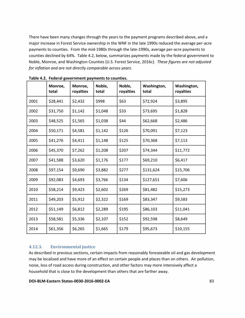
DOI-BLM-Eastern States-0030-2016-0002-EA 83
There have been many changes through the years to the payment programs described above, and a
major increase in Forest Service ownership in the WNF in the late 1990s reduced the average per-acre
payments to counties. From the mid-1980s through the late-1990s, average per-acre payments to
counties declined by 64%. Table 4.2, below, summarizes payments made by the federal government to
Noble, Monroe, and Washington Counties (U.S. Forest Service, 2016c). These figures are not adjusted
for inflation and are not directly comparable across years.
Table 4.2. Federal government payments to counties.
Monroe, total
Monroe, royalties
Noble, total
Noble, royalties
Washington, total
Washington, royalties
2001 $28,441 $2,432 $998 $63 $72,924 $3,895
2002 $31,750 $1,142 $1,048 $33 $73,695 $1,828
2003 $48,525 $1,565 $1,038 $44 $62,668 $2,486
2004 $50,171 $4,581 $1,142 $126 $70,091 $7,123
2005 $41,276 $4,411 $1,148 $125 $70,368 $7,113
2006 $45,370 $7,262 $1,208 $207 $74,344 $11,772
2007 $41,588 $3,620 $1,176 $177 $69,210 $6,417
2008 $97,154 $9,690 $3,882 $277 $131,624 $15,706
2009 $92,083 $4,693 $3,766 $134 $127,651 $7,606
2010 $58,214 $9,423 $2,602 $269 $81,482 $15,273
2011 $49,203 $5,912 $2,322 $169 $83,347 $9,583
2012 $51,149 $6,812 $2,289 $195 $86,103 $11,041
2013 $58,581 $5,336 $2,107 $152 $92,598 $8,649
2014 $61,356 $6,265 $1,665 $179 $95,673 $10,155
4.12.3. Environmental justice
As described in previous sections, certain impacts from reasonably foreseeable oil and gas development
may be localized and have more of an effect on certain people and places than on others. Air pollution,
noise, loss of road access during construction, and other factors may more intensively affect a
household that is close to the development than others that are farther away.
DOI-BLM-Eastern States-0030-2016-0002-EA 84
As detailed in Chapter 3, the private lands surrounding the Forest Service lands are owned by people of
a variety of income and education levels. Someone who is living in poverty may be more prone than a
wealthy person to grant an operator access without carefully considering potential impacts to his or her
household, such as noise, loss of vegetation, soil erosion, and air pollution. The same could be said of a
landowner with little education, who does not understand a landowner’s legal rights, and it is possible
that a landman might target such low-income, uneducated landowners when choosing between
multiple suitable locations for a pad or other infrastructure.
If an operator wishes to drill on federal surface the Forest Service would ensure that proposed activities
are not causing undue inconvenience or harm to neighboring landowners. If an operator wishes to drill
on private surface, then it is the operator’s responsibility to make a good-faith effort to come to an
agreement with the surface owner, and the BLM would arrange an on-site meeting with the surface
owner, the operator, and other relevant parties. The BLM would use this opportunity to ensure that the
surface owner knows his or her rights by providing a copy of the BLM pamphlet entitled Split Estate:
Rights, Responsibilities, and Opportunities (Bureau of Land Management, 2007), thereby minimizing the
potential for environmental justice concerns.
4.13. Cumulative Effects CEQ regulations direct proponents to consider the potential environmental impacts resulting from “the
incremental impacts of the action when added to past, present, and reasonably foreseeable future
actions regardless of what agency or person undertakes such other actions" (40 CFR 1508.7). Recent
CEQ guidance in considering cumulative effects involves defining the scope of the other actions and
their interrelationship with the Proposed Action. The scope must consider geographical and temporal
overlaps among the Proposed Actions and other actions. It must also evaluate the nature of interactions
among these actions.
Cumulative effects are most likely to arise when a relationship or synergism exists between the
Proposed Action and other actions expected to occur in a similar location or during a similar time period.
Actions overlapping with or in proximity to the Proposed Action would be expected to have more
potential for a relationship than those more geographically separated.
To identify cumulative effects, three fundamental questions need to be addressed:
Does a relationship exist such that affected resource areas of the Proposed Action might interact
with the affected resource areas of past, present, or reasonably foreseeable actions?
If one or more of the affected resource areas of the Proposed Action and another action could
be expected to interact, would the Proposed Action affect or be affected by impacts of the other
action?
If such a relationship exists, then does an assessment reveal any potentially significant impacts
not identified when the Proposed Action is considered alone?
DOI-BLM-Eastern States-0030-2016-0002-EA 85
The scope of the cumulative effects analysis involves both the geographic extent of the effects and the
time frame in which the effects could be expected to occur. For this EA, the affected area includes the
proposed lease area and surrounding vicinity.
4.13.1. Context for Cumulative Effects Analysis
Several specific, planned and completed projects on the Marietta Unit have had or will have effects on
plant and animal habitat and populations:
● approval of an electric line that crosses 600 feet of NFS lands, 2009
● habitat improvement for yellow-fringed orchid on 38.5 acres using a variety of mechanical and
chemical treatments and minor construction activities, 2010
● approval of three oil and gas wells, 2010
● renewal of two miles of electric pipeline permits, ranging in width from 15 to 80 feet, 2010
● renewal of 61 acres of hay and row-crop cultivation and 114 acres of grazing, most of which is in
river corridor management area, 2010
● renewal of permits for 3,300 feet of road access, 2010
● approval of laying approximately 2,500 feet of 1½-inch plastic pipeline on surface
● mechanical treatments on managed openings, 2011
● habitat management, including 564 acres of early successional habitat creation, 432 acres of all-
aged stands using single-tree and group selection, and 870 acres of prescribed burning, 2011
● approval of an Application for Permit to drill a vertical oil and gas well on a 0.74-acre pad with a
250-foot access road, 2013
● plugging and abandonment of six orphaned wells, 2014
● 4.4-mile expansion of Kinderhook equestrian trail, 2015
● approval of a 150-foot-by-10-foot ATV trail to serve an oil and gas well, 2015
The ability to accurately assess potential cumulative impacts in this EA is limited due to the lack of site-
specific information for potential future oil and gas development activities. Upon receipt of an APD,
which would identify specific parcel(s) for development, a site-specific analysis would be conducted.
The RFDS can be used to generalize cumulative impacts that could occur associated with the proposed
leasing action. In addition to considering the potential future effects associated with the RFDS, other
activities occurring in the WNF (as documented in the 2006 Forest Plan and 2012 SIR), were taken into
account. The cumulative effects analysis does not consider potential leasing in other areas of the WNF,
such as the Athens Unit or Ironton District. This is because any impacts associated with leasing in these
areas would be separated sufficiently in time and location from the Proposed Action that cumulative
impacts would not be expected.
The majority of the federal surface is over private mineral interests. Leasing and development of federal
minerals under federal surface is subject to more stringent government regulation than non-federal
minerals. Therefore, one result of this leasing action would be more federal oversight of the
DOI-BLM-Eastern States-0030-2016-0002-EA 86
development in the Marietta Unit. There would be very little federal oversight in the development of
private minerals under federal surface.
The cumulative effects analysis presented in the following sections includes information from and refers
to Chapter 3 of the 2006 Forest Plan Final EIS.
4.13.2. Cumulative Effects Analysis
4.13.2.1. Cumulative Effects on Air Resources
It would be impossible to develop reliable projections of GHG emissions resulting from oil and gas
leases, but it is likely that leasing minerals may lead to the installation and production of new wells,
which may consequently produce an increase in GHG emissions. Many aspects of oil and gas production
emit greenhouse gases (GHG). The primary aspects include the following:
● Fossil fuel combustion for construction and operation of oil and gas facilities – vehicles driving to and from production sites, engines that drive drill rigs, etc. These produce CO2 in quantities that vary depending on the age, types, and conditions of the equipment as well as the targeted formation, locations of wells with respect to processing facilities and pipelines, and other site-specific factors.
● Fugitive CH4 – CH4 that escapes from wells (both gas and oil), oil storage, and various types of processing equipment. This is a major source of global CH4 emissions. These emissions have been estimated for various aspects of the energy sector, and starting in 2011, producers are required under 40 C.F.R. §98, to estimate and report their CH4 emissions to the EPA.
● Combustion of produced oil and gas – it is expected that operations will produce marketable quantities of oil and/or gas. Combustion of the oil and/or gas would release CO2 into the atmosphere. Fossil fuel combustion is the largest source of global CO2.
The assessment of GHG emissions, their relationship to global climatic patterns, and the resulting
impacts, is an ongoing scientific process. It is not known with certainty the net impacts from the
Proposed Action on climate – that is, while BLM actions may contribute to the climate change
phenomenon, the specific effects of those actions on global climate are speculative given the current
state of the science. The BLM does not have the ability to associate a BLM action’s contribution to
climate change with impacts in any particular area. The science to be able to do so is not yet available.
Inconsistencies in the results of scientific models designed to predict climate change on regional or local
scales limits the ability to quantify potential future impacts of decisions made at this level and
determining the significance of any discrete amount of GHG emissions is beyond the limits of existing
science. When further information on the impact to climate change is known, such information would
be incorporated in the BLM’s planning and NEPA documents as appropriate but an assessment of
impacts on climate change from the release of GHGs is outside the scope of this document because it is
a global phenomenon.
In recent years, many states, tribes, and other organizations have initiated GHG inventories, tallying
GHG emissions by economic sector. The EPA provides links to statewide GHG emissions inventories
DOI-BLM-Eastern States-0030-2016-0002-EA 87
(U.S. Environmental Protection Agency, 2015c). Guidelines for estimating project-specific GHG
emissions are available (URS Corporation, 2010), but some additional data, including the volume of oil
produced and the number of wells, are not available for the Proposed Action. Uncertainties regarding
the numbers of wells and other factors make it impractical to project amounts of GHG that the Proposed
Action would emit. At the APD stage, more site-specific information on oil and gas activities resulting in
GHG impacts would be described in detail. Also at the APD stage, the BLM would evaluate operations,
require mitigation measures, and encourage operators to participate in the voluntary STAR program.
4.13.2.2. Cumulative Effects on Plant and Animal Habitat and Populations
The most important actions contributing to cumulative effects in the Marietta Unit are the intensive
resource extraction – especially timber removal – that dominated much of the Twentieth Century, which
greatly simplified vegetative structure and wildlife habitat, and the development of the Wayne National
Forest, which has restored healthy forests throughout the Marietta Unit. Timber extraction focused on
clearcutting, removing whole stands and leaving denuded areas to regenerate as single-aged stands of
just a few, shade-intolerant species. A related effect of intensive settlement of the area was the
suppression of wildfire, which is a natural force that is important to the propagation of oak forests.
The development of the WNF has resulted in the active reforestation of cleared sites and the
development of long-term goals, objectives, and targeted management areas. This long-term process
has coincided with the passive and active reforestation of tens of thousands of additional acres
throughout the Marietta Unit, as farming has declined as a land use and less-destructive methods for
mineral extraction have been employed over the last several decades.
The broader actions that are described in the 2006 Forest Plan are expected, over the coming decades,
to result in a decline in oak-dominated stands, which depend on periodic disturbance, and to produce an
increase in acres forested in shade-tolerant, fire-intolerant species like maples. The Forest Service will
continue to promote early-successional habitats and will use site-specific stipulations and guidelines to
manage known locations and suitable habitats for threatened and endangered species. The Ohio DNR’s
hunting regulations are the primary tool for managing the state’s deer herd at a level that ensures
recreational hunting opportunities while mitigating crop damage, and the WNF’s restrictions on ginseng
harvesting are expected to ensure the viability of that species for collection.
4.13.2.3. Cumulative Effects on Water Resources and Water Quality
The impacts to water resources and water quality would occur within the context of several decades of
activities that have had various types of impacts on water resources. The most prominent actions
whose effects are visible on the landscape are the intensive resource extraction in the last century and
the formation of the WNF.
Intensive mining, timber extraction, and farming through much of the Twentieth Century had broad
impacts on surface water resources. Surface mining has included rerouting waterways, and acid mine
drainage has polluted many waterways and extirpated much of the aquatic life in them. Timber
DOI-BLM-Eastern States-0030-2016-0002-EA 88
extraction has left many steep slopes denuded of vegetation and cleared vegetation from riparian areas,
leading to mass wasting and severe soil erosion into waterways. Riparian areas serve a critical role in
watershed and local hydrology health and any disturbance to its function could be harmful to habitat in
surrounding areas (U.S. Department of Agriculture, 1996).
The formation of the WNF has initiated and continued the restoration and management of the
watersheds in the Marietta Unit. The Forest Service has conducted many acid mine drainage and
abandoned mine lands restoration projects, reducing sedimentation and acidification in many
waterways. By reestablishing vegetation and managing healthy forests, especially on steep slopes and
other erosion-prone areas, the Forest Service has reduced sediment loads in streams. At the same time,
forests on private lands throughout the Marietta Unit have been reforested in recent decades, further
reducing erosion and improving surface water quality.
4.13.2.4. Cumulative Effects on Soils
Increases in mineral development, construction activities, and the conversion of land to developed
landscapes collectively result in the removal of vegetation, long-term reduction in vegetation cover, and
disturbance of soils. This would expose soils to the erosive forces of wind and water, destabilize soils,
and increase overland flow, which in turn could result in accelerated erosion. Accelerated erosion could
mobilize soils and remove nutrient-rich topsoil, and thereby reduce soil productivity and vegetation
growth rates. However, the use of best management practices such as those discussed in Section 4.5
would minimize cumulative effects on soils.
4.13.2.5. Cumulative Effects on Mineral Resources
There would be no cumulative impacts to minerals from the administrative action of leasing, but the
potential reasonably foreseeable development projected under the RFDS in combination with other
mineral development activities in the Marietta Unit would result in a minor incremental effect from
development on BLM federal mineral estate. At this stage it is uncertain how productive the wells
accessing the federal mineral estate would be, should development occur in the future. If developed,
the mineral resources would be drained and depleted over time.
4.13.2.6. Cumulative Effects from Wastes
As noted in the Proposed Action description, impacts from waste storage, handling, and disposal would
be minimized through the use of BMPs, SOPs, and COAs at the APD stage, should federal minerals be
proposed for development. Other mineral development, agriculture, and timber management activities
in the area would need to comply with all required laws and regulations with regard to wastes.
Therefore, cumulative effects from wastes are not anticipated.
4.13.2.7. Cumulative Effects on Recreation and Land Use
There would be no cumulative impacts to recreation and land use as a result of leasing; however, there
are potential effects to both if future development activities occur on or near the leased parcels. As
discussed in 4.8, noise caused by exploration activities would result in wildlife temporarily vacating the
DOI-BLM-Eastern States-0030-2016-0002-EA 89
area, reducing hunting and wildlife viewing opportunities for that time. Reasonably foreseeable
development of minerals would also affect other recreational activities, particularly those located at
developed recreation sites, and noise may cause forest visitors to look for recreational activities
elsewhere until exploration is complete. Under the no action alternative, there would be affect to
recreational activities.
4.13.2.8. Cumulative Effects on Cultural Resources and Native American Concerns
There would be no cumulative impacts to cultural resources as a result of leasing; however, potential
cumulative effects to cultural resources could occur if future development activities on or near the lease
parcels are conducted without proper surveys and consultations under the NHPA or state requirements.
Cumulative effects from repetitious illegal activity, primarily archeological vandalism, may occur on
certain sites or site types unless perpetrators are apprehended and prosecuted. The degree of
cumulative effects to known properties from BLM activities, however, should be slight as inventory,
assessment, protection, and mitigation measures would be implemented at the APD stage if federal
minerals are accessed. Under the No Action Alternative, operators in the vicinity would be required to
comply with all required laws and regulations with regard to protection of cultural resources and Native
American Concerns.
4.13.2.9. Cumulative Effects on Visual Resources and Scenic Quality
The act of leasing would have no cumulative effects on visual resources and/or scenic quality of the
Marietta Unit. Should development occur on leased parcels, there could be cumulative effects based on
the number of well pads, roads and any other associated development which could include pipelines
and power. Upon receipt of an APD, further site-specific analysis would be completed and cumulative
effects on visual resources and scenic quality analyzed in relation to other projects or potential projects.
4.13.2.10. Cumulative Effects on Socioeconomics
The economic conditions of southeastern Ohio have been changing over the past years and decades as a
result of many factors and decisions. As described above, timber production was once a much larger
generator of wages and downstream economic activity than it is at present. Mineral production,
including coal, limestone, dolomite, sand, and gravel, decreased in economic value of production as well
as in employment between 1970 and 2000. More recently, oil and gas production in the region has
caused an increase in wages, employment, and downstream economic activity.
The primary action that affects the economic conditions of southeastern Ohio is the ownership of the
Wayne National Forest. The Forest Service’s Social and Economic Assessment (Arbogast, 2004) states
that federal ownership of lands comprising the WNF is beneficial to local, rural economies for several
reasons. First, the federal government supports the counties through various types of payments and
cost-share programs. Second, the federal government maintains the roads and other infrastructure on
NFS lands. Finally, the presence of the National Forest stimulates local economies as visitors to the
national forest contribute money that they spend for outdoor gear, lodging, food, and other expenses.
DOI-BLM-Eastern States-0030-2016-0002-EA 90
4.14. Irreversible and Irretrievable Commitments of Resources NEPA Section 102(2)C requires a discussion of any irreversible or irretrievable commitments of
resources that would be involved in the proposal should it be implemented. An irreversible
commitment of a resource is one that cannot be reversed (e.g., the extinction of a species or
disturbance to protected cultural resources). An irretrievable commitment of a resource is one in which
the resource or its use is lost for a period of time (e.g., extraction of any solid mineral ore or fluid
mineral).
Reasonably foreseeable future oil and gas development associated with the Proposed Action would
result in surface disturbing activities that would result in irreversible or irretrievable commitments of
resources. These surface disturbing activities would result in alterations to soil, removal of vegetation
cover and wildlife habitat, and possible damage to cultural resources if proper surveys and consultations
are not conducted under the NHPA. Increases in sediment and nonpoint source pollution that result
from these activities could result in degradation of water quality within the watershed and habitat for
aquatic-dependent species, although no major surface waters are located adjacent to the parcel. Use of
BMPs, SOPs, COAs and stipulations as described in the EA are designed to reduce the magnitude of
these impacts by preventing habitat degradation.
Development of oil and gas wells would represent an irretrievable commitment of nonrenewable fossil
fuels.
4.15. Relationship between Local Short-term Uses and Long-term
Productivity NEPA requires an analysis of the relationship between a project’s short-term impacts on the
environment and of the effects that these impacts may have on the maintenance and enhancement of
the long-term productivity of the affected environment. Impacts that narrow the range of beneficial
uses of the environment are of particular concern. This refers to the possibility that choosing one
development option reduces future flexibility in pursuing other options, or that giving over a parcel of
land or other resource to a certain use eliminates the possibility of other uses being performed at the
site.
The Proposed Action would take place within a national forest. While vegetation loss from future
development would occur, no unique habitat or ecosystems would be lost due to this action.
Implementation of the Proposed Action or No Action Alternative may result in future oil and gas
development, which results in surface-disturbing and other disruptive activities that remove vegetation,
increase soil erosion and compaction, create visual intrusions and landscape alterations, increase noise,
and degrade wildlife habitat. Although management actions, BMPs, surface use restrictions, and lease
stipulations are intended to minimize the effect of short-term uses, some impact on long-term
productivity of resources would occur.
DOI-BLM-Eastern States-0030-2016-0002-EA 91
4.16. No action alternative for all resources The no action alternative would preclude leasing of federal minerals under the Marietta Unit of the
WNF. The direct and indirect effects described above would, for the most part, not occur. If the BLM
does not sell mineral leases, then the revenues that would be produced by leasing and, potentially, by
mineral production may not be made available to the counties. Failure to lease would result in private
mineral development and drainage of the federal minerals without any benefit to the government.
5 LEASE-SPECIFIC OIL AND GAS NOTIFICATIONS AND STIPULATIONS
Introduction The text of this section is taken directly from Appendix H to the Forest Plan.
The following notifications and stipulations implement the standards and guidelines of the Wayne
National Forest’s 2006 Land and Resource Management Plan (Forest Plan). These are in addition to the
standard lease terms for oil and gas leases (BLM Form 3100-11). Not all of these notifications and
stipulations are applied to every lease, rather, only those that are relevant based on site conditions.
These notifications and stipulations are necessary to protect specific resource values on the lease area.
They may be made less restrictive or modified for site-specific situations if such change is found to be in
the public interest. These notifications and stipulations may be made less restrictive or modified only
after a formal analysis has been completed and specifically approved in writing by a Forest Service line
officer.
Notifications Special Notification #1 Operations under this lease will be consistent with all the standards and guidelines found in the Wayne
National Forest’s 2006 Land and Resource Management Plan and are hereby incorporated into this lease
in its entirety. Forest Plan standards and guidelines may restrict location, timing, and methodology of oil
and gas lease operations. Special surveys for protection of National Forest System land and resources
will be required. A copy of the WNF’s 2006 Land and Resource Management Plan is available from the
following website http://www.fs.fed.us/r9/wayne/ or by writing to:
Forest Supervisor
Wayne National Forest
13700 US HWY 33
Nelsonville, OH 45764
Notification #1 - Cultural Resources The Forest Service is responsible for assuring the area to be disturbed is examined for cultural resources
prior to allowing surface disturbing activities on lands covered by this lease. Important cultural resource
DOI-BLM-Eastern States-0030-2016-0002-EA 92
values may be present on portions of a lease. Surface disturbing activities must avoid these areas unless
the authorized officer agrees to the mitigation measures. The lessee/operators may, at their discretion
and cost, conduct the examination on the lands to be disturbed. This examination must be done by or
under the supervision of a qualified resource specialist approved by the Forest Service. An acceptable
report must be provided to the Forest Service identifying the anticipated effects of the Proposed Action
on cultural resource values. If items of substantial archaeological or paleontological values are
discovered during operations, or a known deposit of such items is disturbed, the lessee (or operator) will
cease work in the affected area. The lessee (or operator) will then notify the Forest Service and will not
resume excavation until the Forest Supervisor gives written approval.
Notification #2 - Floodplains Any activities proposed in, or likely to affect a floodplain will be subject to:
• Analysis and identification of alternate sites
• Public notification and comment period
• Provisions of any other federal, State or local laws and regulations as required under presidential
Executive Order 11988, Protection of Floodplains.
Notification #3 - Protection of Federally Listed Endangered and Threatened and Regional Sensitive Species and their Habitats The Forest Service is responsible for assuring that the area to be disturbed is examined prior to allowing
any surface disturbing activities on lands covered by this lease. The examination is to determine effects
upon any plant or animal species listed, or proposed for listing, as federal endangered or threatened,
regional sensitive, and their habitats. If the findings of this examination determine that the operation(s)
may have a detrimental effect on a species covered by the federal Endangered Species Act, the
operator’s plans may be denied or restrictions added. The presence of regional sensitive species may
also require some restrictions of the operation(s).
The Forest Service has the responsibility to conduct the required examination. In cases where the
Forest Service time frames cannot meet the needs of the lessee/operator, the lessee/operator may, at
his discretion and cost, conduct the examination on the lands to be disturbed. This examination must
be done by or under the supervision of a qualified resource specialist approved by the Forest Service.
An acceptable report must be provided to the Forest Service identifying the anticipated effects of the
Proposed Action on federal endangered or threatened species, regional sensitive species, or their
habitats.
Notification #4 - Compliance with Public Laws and Federal Regulations Operators are required to comply with all public laws and federal regulations that apply to National
Forest System lands and the Wayne National Forest’s 2006 Land and Resource Management Plan.
DOI-BLM-Eastern States-0030-2016-0002-EA 93
Notification #5 - Steep Slopes and/or Unstable Soils The area of this lease contains a considerable amount of land with steep slopes and/or unstable soils.
Accordingly, the opportunity to locate access roads, drilling sites, pipelines, storage tanks and other
improvements may be extremely limited.
Management Areas Requiring Special Stipulations Stipulation #1 - No Surface Occupancy - Future Old Forest No surface occupancy allowed on the entire lease or on designated areas of the lease (see lease map)
for the protection of the Future Old Forest resources.
On National Forest System land in Future Old Forest Management Areas, the Forest Service will issue
leases for federal oil and gas only with a No Surface Occupancy (NSO) stipulation. In the case of federal
leases issued pursuant to the Comprehensive National Energy Policy Act of 1992, the Forest Service will
recommend to the Bureau of Land Management that operations be allowed to continue provided that
all activities comply with Forest guidance. When the existing well (or wells) is depleted, all facilities
must be removed and the site rehabilitated to Forest Service standards. No new wells will be allowed,
nor will existing wells be allowed to be drilled to deeper formations. The NSO stipulation does not apply
to reserved or outstanding mineral rights.
Stipulation #2 - No Surface Occupancy - Research Natural Areas No surface occupancy within designated areas of the lease (see lease map) for the protection of natural
processes or research, historical, or educational values.
On National Forest System land in Research Natural Area Management Areas, the Forest Service will
issue leases for federal oil and gas only with a No Surface Occupancy (NSO) stipulation. In the case of
federal leases issued pursuant to the Comprehensive National Energy Policy Act of 1992, the Forest
Service will recommend to the Bureau of Land Management that operations be allowed to continue
provided that all activities comply with Forest guidance. When the existing well (or wells) is depleted, all
facilities must be removed and the site rehabilitated to Forest Service standards. No new wells will be
allowed, nor will existing wells be allowed to be drilled to deeper formations. The NSO stipulation does
not apply to reserved or outstanding mineral rights.
Stipulation #3 - No Surface Occupancy - Special Areas No surface occupancy within designated areas of the lease (see lease map) to protect natural processes
or research, historical or educational values.
On National Forest System land in Special Interest Management Areas, the Forest Service will issue
federal oil and gas leases only with a No Surface Occupancy (NSO) stipulation. In the case of federal
leases issued pursuant to the Comprehensive National Energy Policy Act of 1992, the Forest Service will
recommend to Bureau of Land Management that operations be allowed to continue provided that all
activities comply with Forest guidance. When the existing well (or wells) is depleted, all facilities must be
DOI-BLM-Eastern States-0030-2016-0002-EA 94
removed and the site rehabilitated to Forest Service standards. No new wells will be allowed, nor will
existing wells be allowed to be drilled to deeper formations. The NSO stipulation does not apply to
reserved or outstanding mineral rights.
Stipulation #4 - No Surface Occupancy - Candidate Areas No surface occupancy within designated areas of the lease (see lease map) for the protection of natural
processes or research, historical or educational values.
On National Forest System lands in Candidate Research Natural Management Areas, the Forest Service
will only issue federal oil and gas leases that have a No Surface Occupancy (NSO) stipulation. In the case
of federal leases issued pursuant to the Comprehensive National Energy Policy Act of 1992, the Forest
Service will recommend to Bureau of Land Management that operations be allowed to continue
provided that all activities comply with Forest guidance. When the existing well (or wells) is depleted, all
facilities must be removed and the site rehabilitated to Forest Service standards. No new wells will be
allowed, nor will existing wells be allowed to be drilled to deeper formations. The NSO stipulation does
not apply to reserved or outstanding mineral rights.
Stipulation #5 - No Surface Occupancy - Administrative Sites, Developed Recreation Areas, Trails, and Associated Trailheads No surface occupancy within designated areas of the lease (see lease map) to protect special
management units such as developed recreation areas, trails and associated trailheads, water supply
facilities, administrative site, etc.
On National Forest System land within administrative sites, developed recreation areas, trails and
associated trailheads, the Forest Service will issue leases for federal oil and gas only with a No Surface
Occupancy (NSO) stipulation. The NSO designation will include a buffer zone, which will be determined
in accordance with the Implementation Guide for Scenery Management. In the case of federal leases
issued pursuant to the Comprehensive National Energy Policy Act of 1992, the Forest Service will
recommend to the Bureau of Land Management that operations be allowed to continue provided that
all activities comply with Forest guidance. When the existing well (or wells) is depleted, all facilities must
be removed and the site rehabilitated to Forest Service standards. No new wells will be allowed, nor will
existing wells be allowed to be drilled to deeper formations. The NSO stipulation does not apply to
reserved or outstanding mineral rights.
Resources Requiring Special Stipulations Stipulation #7 - No Surface Occupancy - Cultural Resources of Known Significance No surface occupancy is allowed within archaeological or historical sites of known significance (see lease
map). At the time of any new proposed lease developments, a Forest Service archeologist shall
determine the need for any setbacks or restrictions for the protection of objects of historic or scientific
interest.

DOI-BLM-Eastern States-0030-2016-0002-EA 95
Stipulation #8 - No Surface Occupancy - Slopes in Excess of 55 Percent No surface occupancy is allowed on slopes in excess of 55 percent (see lease map) to protect soil and
water from erosion and mass failure hazards because of steep slopes.
Stipulation #9 - No Surface Occupancy - Areas of Mass Instability No surface occupancy is allowed for the exploration and development of energy minerals on areas with
mass soil instability, as defined by the USDA County Soil Surveys (see lease map).
Stipulation #10 - No Surface Occupancy - Hibernacula No surface occupancy within ¼ mile of all known Indiana bat hibernacula.
Stipulation #11 - Controlled Surface Use - Areas of Land with a Scenic Integrity Objective of ‘High’ or ‘Moderate’ At the time of any new proposed lease developments, the responsible line officer shall determine the
need for any visual quality mitigation. Some examples of mitigation may include special design and
reclamation measures, transplanting trees and shrubs, fertilization, mulching, special erosion control
structures, irrigation, site recontouring to match the original land contour, low profile equipment and
painting to minimize contrast. Surface occupancy may also be limited or denied in sensitive areas, such
as unique geologic features and rock formations, visually prominent areas such as designated trails and
developed recreation sites.
Stipulation #12 - Controlled Surface Use - Known Locations of Federally Listed Species No cutting of snags (trees with less than 10% live canopy), shagbark or shellbark hickories, or trees that
are hollow and/or have major splits or broken tops, except during the bat hibernation season
(September 15 through April 15). If such trees are a safety hazard, they may be cut anytime they pose an
imminent threat to human safety, but if cut in the nonhibernation season the Forest Service biologist
must be notified in advance. This stipulation applies only to trees over six inches in diameter.
Protect all supercanopy trees or other identified congregation roost trees for bald eagles along major
river corridors and lakes. Protect known nests and roosts as described in the Bald Eagle Recovery Plan,
or as directed by the U.S. Fish and Wildlife Service.
Prior to any surface disturbing activities a Forest Service biologist will conduct an assessment for
potential American burying beetle habitat and occurrence. Occupancy restrictions will be determined at
the time of the evaluation.
Stipulation #13 - Controlled Surface Use - Known Locations of Regional Forester Sensitive Species Controlled surface use may include setbacks or restrictions from portions of the lease to ensure
protection of habitat for regional sensitive species. At the time of any new proposed lease
developments, the responsible line officer shall determine the need for any setbacks or restrictions, or
the need for timing-related stipulation in accordance with the aquatic and terrestrial wildlife and
botanical resources standards and guidelines.
DOI-BLM-Eastern States-0030-2016-0002-EA 96
The leaseholder and Forest Service inspector shall work together to identify locations for development
and production facilities in order to protect the structural integrity of large old trees found on a portion
of the tract.
Stipulation #14 - Controlled Surface Use - Managed Wildlife Openings At the time of any new proposed lease developments, the responsible line officer shall determine the
extent of the surface use restrictions necessary to maintain habitat integrity for plant and animal species
dependent on such habitats.
Stipulation #15 - Controlled Surface Use - Riparian Areas At the time of any new proposed lease developments, the responsible line officer shall determine the
appropriate surface use restrictions necessary to maintain the structural and ecological integrity of
riparian areas, and aquatic and riparian-dependent species viability.
Stipulation #16 - Controlled Surface Use - Portions of Floodplains Outside Riparian Areas Oil and gas activities may be allowed within that portion of a floodplain outside riparian areas. Mineral
activities will be evaluated on a case-by-case basis, and appropriate mitigation measures will be applied.
The leaseholder and Forest Service inspector shall work together to identify locations for roads,
pipelines, well pads and production facilities.
Stipulation #17 - Controlled Surface Use - Slopes Between 35 and 55 Percent Oil and gas activities will be allowed on slopes from 35 to 55 percent on a case-by-case basis with
appropriate mitigation. New road construction and maintenance shall be planned to disturb the least
amount of ground. The leaseholder and Forest Service inspector shall work together to identify locations
for roads, pipelines, well pads, and production facilities.

DOI-BLM-Eastern States-0030-2016-0002-EA 97
6 MAPS
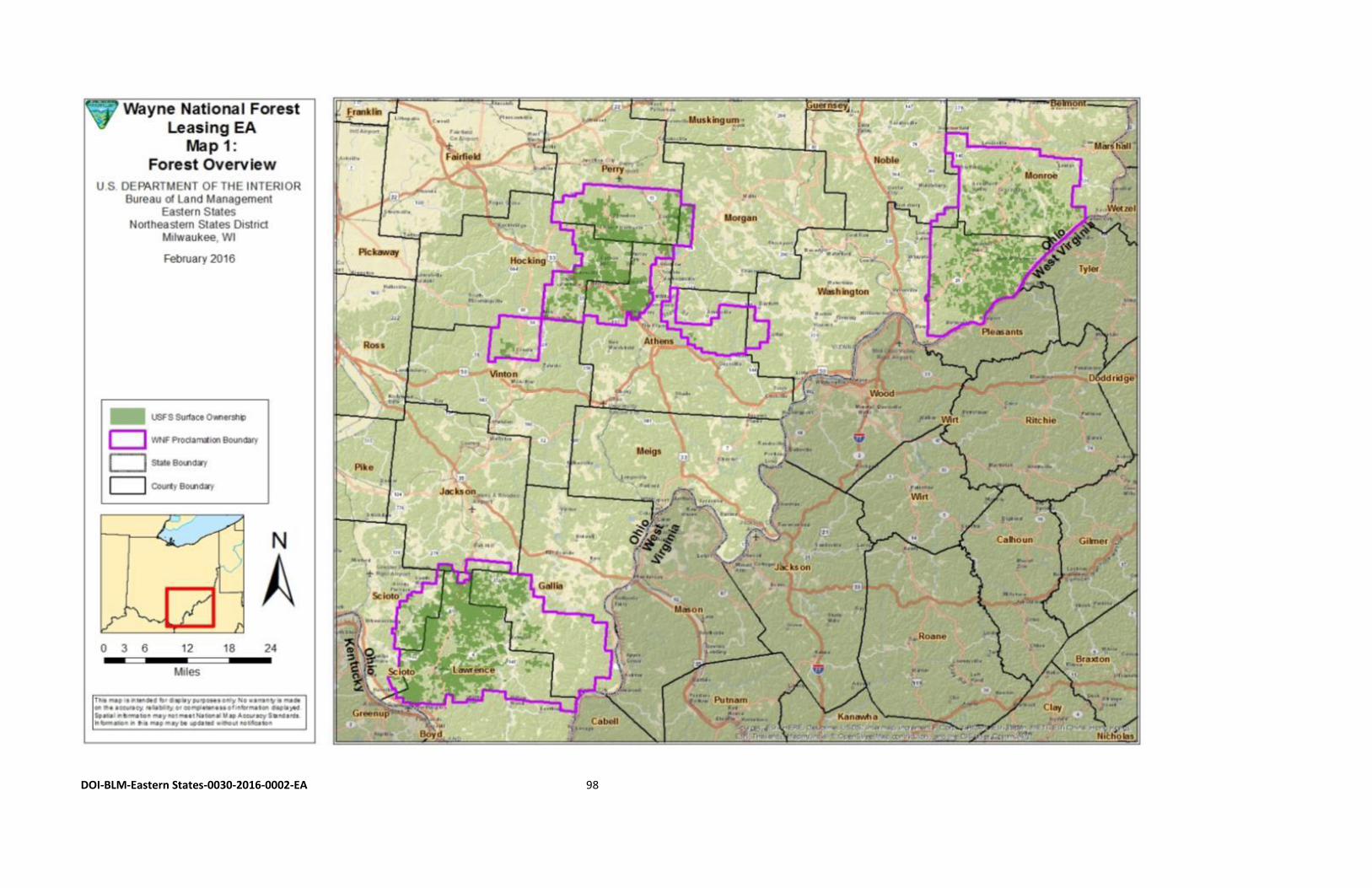
DOI-BLM-Eastern States-0030-2016-0002-EA 98
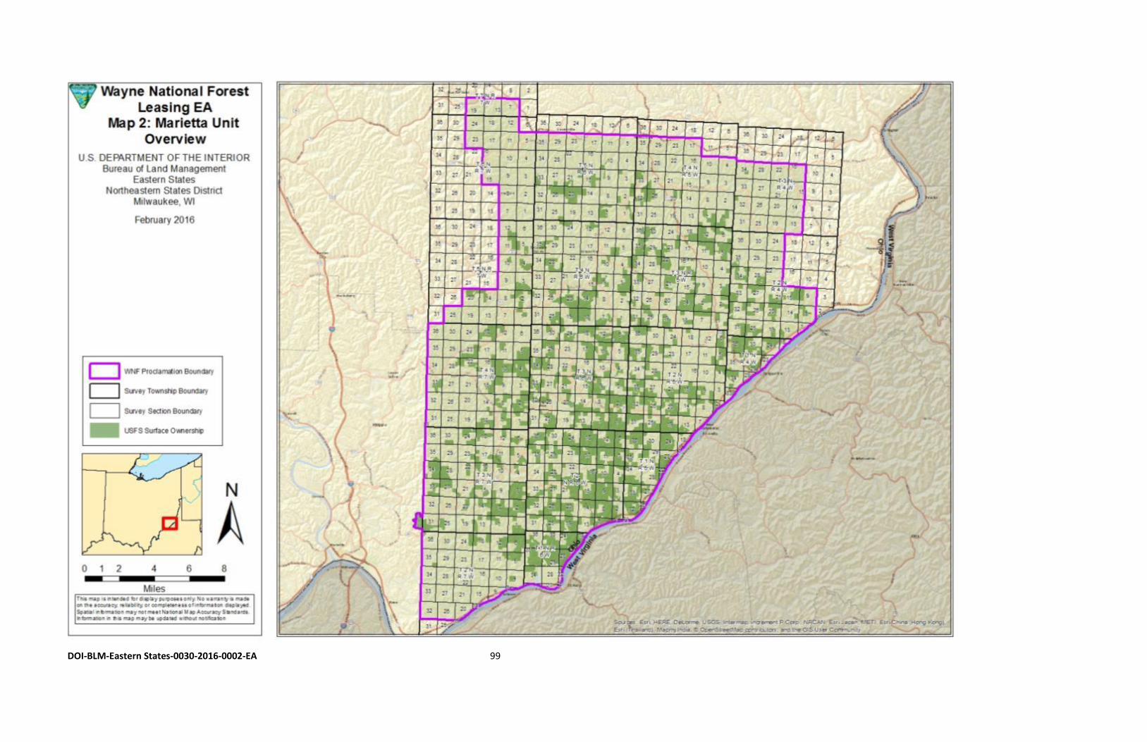
DOI-BLM-Eastern States-0030-2016-0002-EA 99
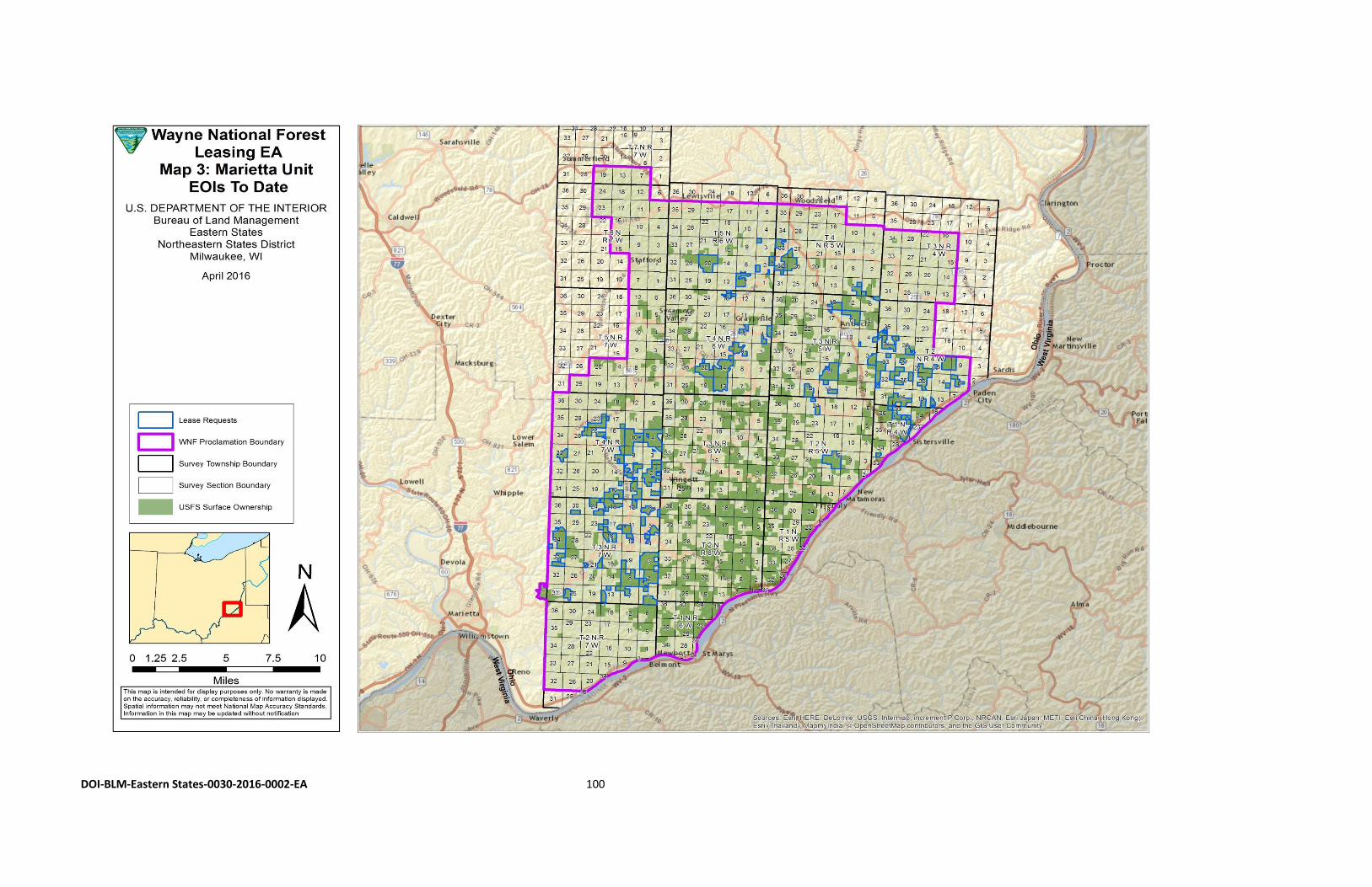
DOI-BLM-Eastern States-0030-2016-0002-EA 100
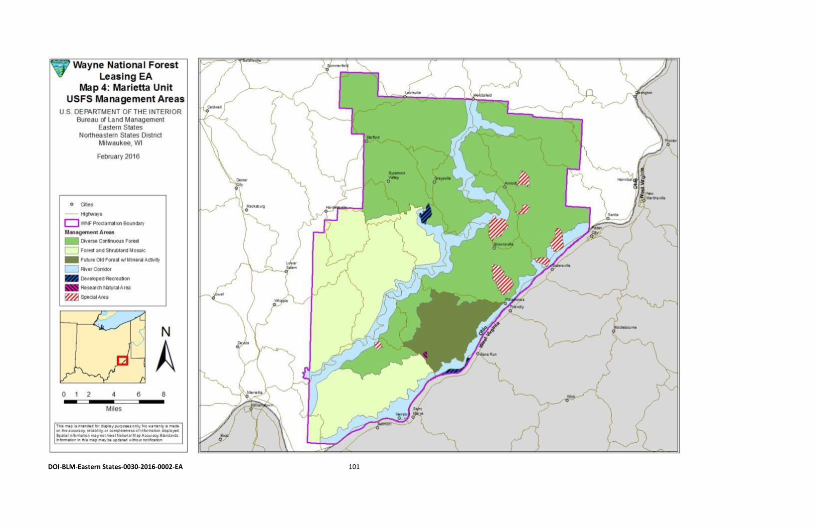
DOI-BLM-Eastern States-0030-2016-0002-EA 101
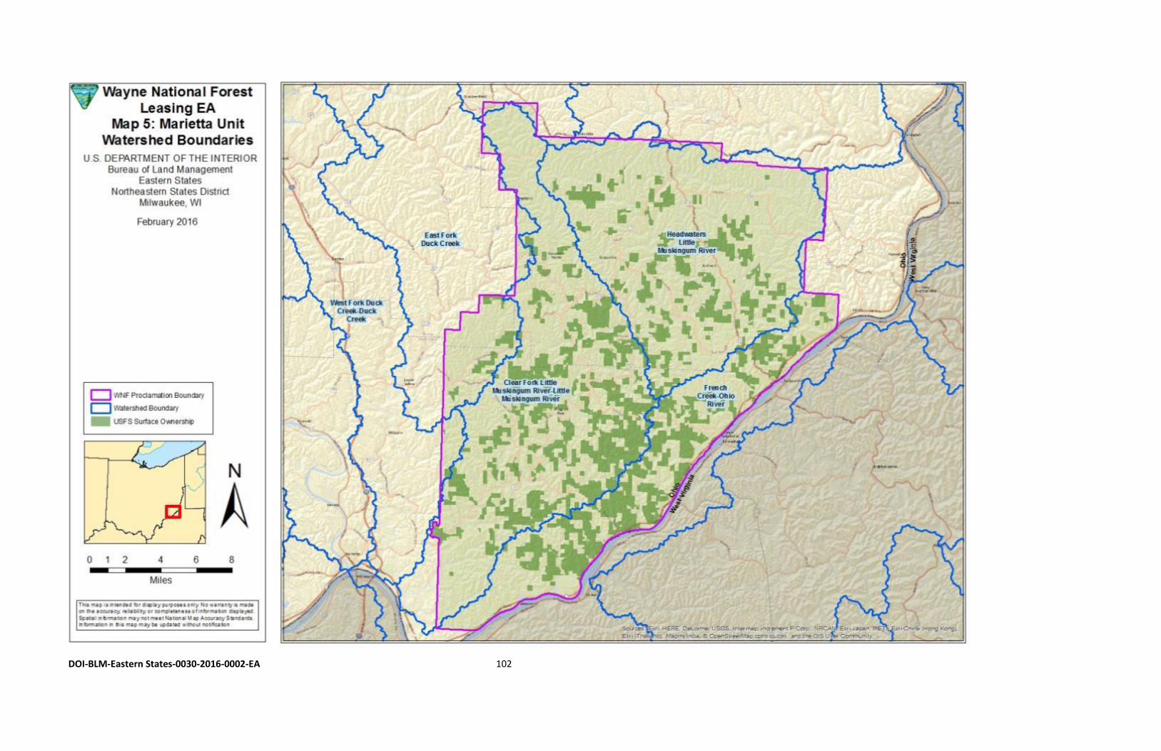
DOI-BLM-Eastern States-0030-2016-0002-EA 102
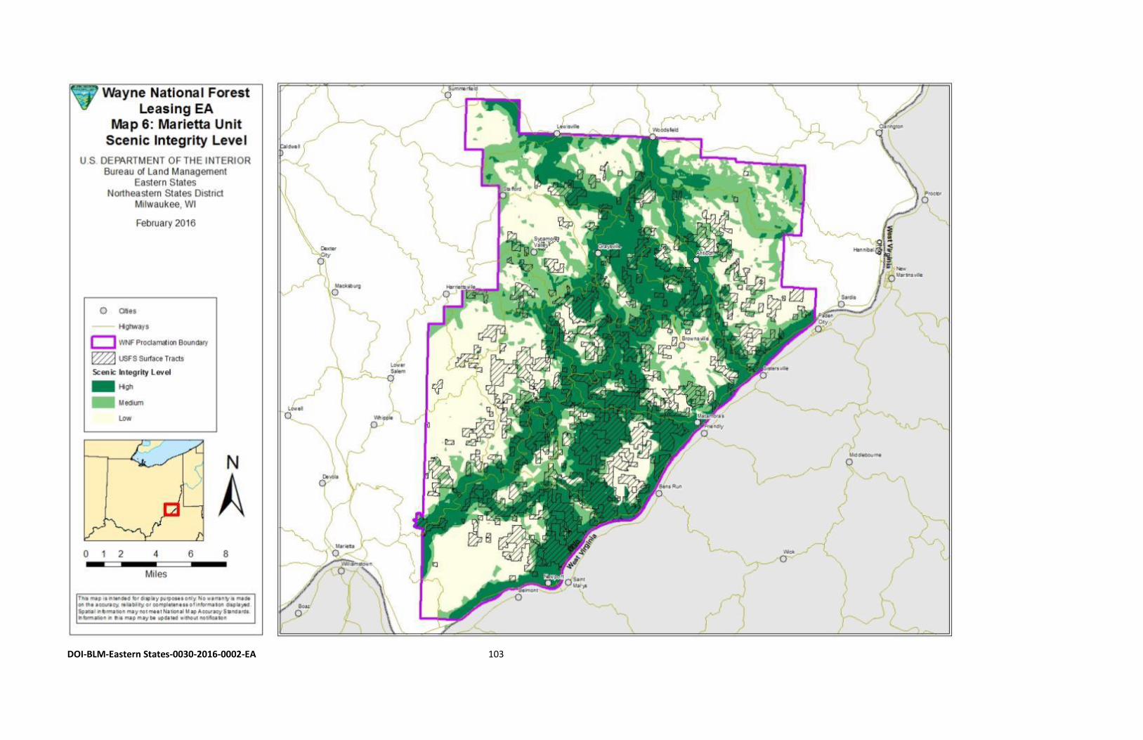
DOI-BLM-Eastern States-0030-2016-0002-EA 103
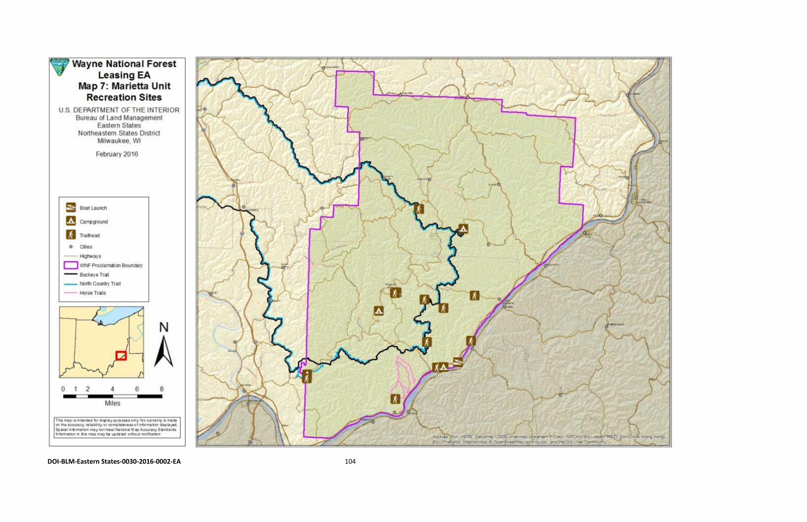
DOI-BLM-Eastern States-0030-2016-0002-EA 104
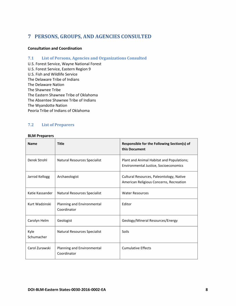
DOI-BLM-Eastern States-0030-2016-0002-EA 8
7 PERSONS, GROUPS, AND AGENCIES CONSULTED Consultation and Coordination
7.1 List of Persons, Agencies and Organizations Consulted
U.S. Forest Service, Wayne National Forest U.S. Forest Service, Eastern Region 9 U.S. Fish and Wildlife Service The Delaware Tribe of Indians The Delaware Nation The Shawnee Tribe The Eastern Shawnee Tribe of Oklahoma The Absentee Shawnee Tribe of Indians The Wyandotte Nation Peoria Tribe of Indians of Oklahoma
7.2 List of Preparers
BLM Preparers
Name Title Responsible for the Following Section(s) of
this Document
Derek Strohl Natural Resources Specialist Plant and Animal Habitat and Populations;
Environmental Justice, Socioeconomics
Jarrod Kellogg Archaeologist Cultural Resources, Paleontology, Native
American Religious Concerns, Recreation
Katie Kassander Natural Resources Specialist Water Resources
Kurt Wadzinski Planning and Environmental
Coordinator
Editor
Carolyn Helm Geologist Geology/Mineral Resources/Energy
Kyle
Schumacher
Natural Resources Specialist Soils
Carol Zurawski Planning and Environmental
Coordinator
Cumulative Effects
DOI-BLM-Eastern States-0030-2016-0002-EA 106
8 REFERENCES Arbogast, K. (2004). Social and Economic Assessment for the Wayne National Forest. Tomas M. Koontz,
PhD (ed.). Nelsonville, OH: U.S. Department of Agriculture, Wayne National Forest. Appalachian Regional Commission. (2016). Maps by topic: Economic status. County economic status in
Appalachia, FY 2016. Retrieved from http://www.arc.gov/research/MapsofAppalachia.asp?F_CATEGORY_ID=1.
Bamberger, M., & Oswald, R. E. (2012). Impacts of gas drilling on human and animal health. In New Solutions, Vol. 22(1), 51-77. doi: http://dx.doi.org/10.2190/NS.22.1.e Boden, T. A., Marland, G., & Andres, R. J. (2013). Global, regional, and national fossil-fuel CO2 emissions. U.S. Department of Energy. Oak Ridge, TN: Carbon Dioxide Information Analysis Center, Oak Ridge National Laboratory. doi:10.3334/CDIAC/00001_V2013 Buonopane, S., Ebright, S., & Smith, A. (2012). Historic American Engineering Record,
Rinard Bridge: HAER No. OH-130. Washington, DC: National Park Service. Retrieved from http://www.loc.gov/pictures/item/oh1983/
Bureau of Land Management. (1998). Mosquito Creek Lake draft planning analysis/Environmental assessment. Milwaukee, WI: Milwaukee District Office. Bureau of Land Management. (2007). Split estate: Rights, responsibilities, and opportunities (BLM Publication No. BLM/WO/GI-06/022+3161/REV 07). Retrieved from Bureau of Land Management website: http://www.blm.gov/wo/st/en/prog/energy/oil_and_gas/best_management_practices/split_est ate.html Fletcher, S. M. (2012). Risk assessment of groundwater contamination from hydraulic fracturing fluid spills in Pennsylvania (Thesis S.M. in Technology and Policy). Cambridge, MA: Massachusetts Institute of Technology, Engineering Systems Division, Technology and Policy Program. Retrieved from http://hdl.handle.net/1721.1/72885 Ground Water Protection Council & ALL Consulting. (2009). Modern shale gas development in the United States: A primer. Oklahoma City, OK. Retrieved from http://www.gwpc.org/resources/publications Hansen J., Sato, M., Ruedy, R., Lo, K., Lea, D.W., & Medina-Elizade, M. (2006). Global temperature change. Proceedings of the National Academy of Sciences 103(39), 14288-14293. National Academy of Sciences of the United States. Retrieved from www.pnas.orgcgidoi10.1073pnas.0606291103
DOI-BLM-Eastern States-0030-2016-0002-EA 107
Independent Petroleum Association of America. (2014). Ohio. In F. J. Lawrence (Ed.), 2013-2014 IPAA oil & gas producing industry in your state, Vol. 83, 86-87. Washington, DC: Independent
Petroleum Association of America. Retrieved from http://www.ipaa.org/
Intergovernmental Panel on Climate Change. (2006). 2006 IPCC guidelines for national greenhouse gas inventories. Task Force on National Greenhouse Gas Inventories. Retrieved from http://www.ipcc-nggip.iges.or.jp/public/2006gl/index.html
Intergovernmental Panel on Climate Change. (2007). Climate change 2007: Mitigation, contribution of
working group III to the fourth assessment report of the Intergovernmental Panel on Climate Change [B. Metz, O. R. Davidson, P. R. Bosch, R. Dave, L. A. Meyer (eds.)]. Cambridge, UK and New York, NY: Cambridge University Press. Retrieved from http://www.ipcc.ch/publications_and_data/publications_ipcc_fourth_assessment_report_wg3_report_mitigation_of_climate_change.htm
IOM (Institute of Medicine). (2014). Fracturing: Accessing shale and tight gas. David Cole, M.S. In C.
Coussens and R. M. Martinez (eds.), Health impact assessment of shale gas extraction: Workshop summary, 17-22. Washington, DC: The National Academies Press. Retrieved from http://www.nap.edu/catalog/18376/health-impact-assessment-of-shale-gas-extraction-workshop-summary
King, G. E. (2012). Hydraulic fracturing 101: What every representative, environmentalist, regulator,
reporter, investor, university researcher, neighbor and engineer should know about estimating frac risk and improving frac performance in unconventional gas and oil wells. SPE 152596. The Woodlands, TX: SPE (Society for Petroleum Engineers) Hydraulic Fracturing Technology Conference, 6-8 February, 2012. Retrieved from https://www.bucknell.edu/script/environmentalcenter/marcellus/default.aspx?articleid=B6GAKZRAOQYKMB9YCSTFEFQ7Z
Lendel, I., Thomas, A. R., Townley, B., Murphy, T., & Kalynchuk, K. (2015). Economics of Utica shale in
Ohio: Workforce analysis. Urban Publications. Paper 1330. Cleveland, OH: Cleveland State University. Retrieved from http://engagedscholarship.csuohio.edu/urban_facpub/1330/
Malm, W. C. (1999). Introduction to visibility. National Park Service Air Resources Division and
Cooperative Institute for Research in the Atmosphere (CIRA). NPS Visibility Program. Under Cooperative Agreement CA2350-97-001: T097-04, T098-06. Fort Collins, CO: Colorado State University. Retrieved from https://www.epa.gov/visibility/introduction-visibility
Malm, W. C., Schichtel, B. A., Barna, M. G., Gebhart, K. A., Rodriguez, M. A., Collett, Jr., J. L.,…S. M.,
Kreidenweis. (2013). Aerosol species concentrations and source apportionment of ammonia at Rocky Mountain National Park. Journal of the Air & Waste Management Association, 63(11), 1245-1263. doi: 10.1080/10962247.2013.804466
National Aeronautics and Space Administration Goddard Institute for Space Studies. (2007). GISS
surface temperature analysis. Retrieved from http://data.giss.nasa.gov/gistemp/2007/
DOI-BLM-Eastern States-0030-2016-0002-EA 108
National Oceanic and Atmospheric Administration. (2016). Climatological rankings. Asheville, NC: National Centers for Environmental Information. Retrieved from http://www.ncdc.noaa.gov/temp-and-precip/climatological-rankings/index.php?periods%5B%5D=60¶meter=tavg&state=33&div=0&month=1&year=2016#ranks-form
Ohio Department of Agriculture. (2016). Plant Health Division - Emerald Ash Borer. Reynoldsburg, OH: Ohio Department of Agriculture. Retrieved from http://www.agri.ohio.gov/divs/plant/eab/eab- index.aspx#tog Ohio Department of Natural Resources. (2002). Groundwater pollution potential, Washington County,
Ohio (GIS data file). Columbus, OH: Ohio Department of Natural Resources. Retrieved from http://geospatial.ohiodnr.gov/data-metadata/search-by-category
Ohio Department of Natural Resources. (2015a). Acid mine drainage abatement program. Columbus,
OH: Division of Mineral Resources. Retrieved from http://minerals.ohiodnr.gov/abandoned-mine-land-reclamation/acid-mine-drainage#AMD
Ohio Department of Natural Resources. (2015b). Water well locations in Monroe County, Ohio (GIS data
file). Columbus, OH: Ohio Department of Natural Resources. Retrieved from http://geospatial.ohiodnr.gov/data-metadata/search-by-category
Ohio Department of Natural Resources. (2015c). Water well locations in Washington County, Ohio (GIS data file). Columbus, OH: Ohio Department of Natural Resources. Retrieved from http://geospatial.ohiodnr.gov/data-metadata/search-by-category
Ohio Department of Natural Resources. (2016a). Abandoned mine land and reclamation programs. Columbus, OH: Division of Mineral Resources. Retrieved from http://minerals.ohiodnr.gov/abandoned-mine-land-reclamation/aml-reclamation-programs#BAC
Ohio Department of Natural Resources. (2016b). Deer harvest numbers. Columbus, OH: Ohio
Department of Natural Resources. Retrieved from http://wildlife.ohiodnr.gov/hunting-trapping-and-shooting-sports/hunting-resources-by-species/deer/deer-harvest-yearly-comparison
Ohio Environmental Protection Agency. (2011). Analysis of visibility impacts of BART-eligible sources on
the regional scale. Columbus, OH: Division of Air Pollution Control. Retrieved from http://www.epa.ohio.gov/portals/27/SIP/regional/D1-BART_TSD_edited_2011-clean.pd
Ohio Environmental Protection Agency. (2016). Ohio integrated water quality monitoring and
assessment report. Columbus, OH: Division of Surface Water. Retrieved from http://epa.ohio.gov/dsw/tmdl/OhioIntegratedReport.aspx#156069519-report
DOI-BLM-Eastern States-0030-2016-0002-EA 109
Ohio Oil and Gas Association. (n.d.). Ohio shale plays. Retrieved from http://www.ooga.org/?page=OhioShalePlays
Ohio Oil and Gas Energy Education Program. (2016). That was then … This is now!. Retrieved from http://oogeep.org/teachers-students/history/
Ohio University and The Ohio State University. (2011). Assuring Ohio’s competitiveness in a
carbon-constrained world: A collaboration between Ohio University and the Ohio State University. Columbus, OH: Ohio Department of Development. Retrieved from http://ohioenergyresources.com/index.aspx
Pennsylvania Department of Conservation and Natural Resources. (n.d.). Marcellus Shale. Retrieved from http://www.dcnr.state.pa.us/
Pickett, A. (2011). Vast Resource Potential Has Operators Gearing Up to Test Utica Shale Formation.
American Oil & Gas Reporter. Retrieved from http://www.aogr.com/magazine Ramanathan, V., & Carmichael, G. (2008). Global and regional climate changes due to black carbon. In
Nature Geoscience, 1, 221-227. doi:10.1038/ngeo156 Reed, M. (2014). Hiking Ohio: A guide to the state’s greatest hikes. Guilford, CT: Globe Pequot Press. Rogers, J. (n.d.). Climate of Ohio. Retrieved from
http://www.geography.ohio-state.edu/faculty/rogers/OOC.pdf
Schiefer, M. C. (2002). Basin descriptions and flow characteristics of Ohio streams. Columbus, OH: Ohio Department of Natural Resources, Division of Water. Retrieved from https://water.ohiodnr.gov/portals/soilwater/pdf/stream/Bulletin47.pdf Stucker, J.D., compiler. (2015). 2014 Report on Ohio mineral industries—An annual summary of the
state’s economic geology. Columbus, OH: Department of Natural Resources, Division of Geological Survey. Retrieved from http://geosurvey.ohiodnr.gov/mineral-resources/minerals-home
Thomas, A. R., Lendel, I., Hill, E. W., Southgate, D., & Chase, R. (2012). An analysis of the economic
potential for shale formations in Ohio. Urban Publications. Paper 453. Cleveland, OH: Cleveland State University. Retrieved from http://engagedscholarship.csuohio.edu/urban_facpub/453/
Thompson, T. (2012). U.S. Forest Service white paper. A summary of the groundwater resources of the
Wayne National Forest. Supplemental information report - Horizontal drilling using high volume hydraulic fracturing - Appendix F. Retrieved from http://www.fs.usda.gov/detail/wayne/landmanagement/planning/?cid=stelprdb5387922
DOI-BLM-Eastern States-0030-2016-0002-EA 110
URS Corporation. (2010). Climate change supplementary information report, Montana, North Dakota and South Dakota Bureau of Land Management. Denver, CO. Retrieved from http://www.blm.gov/mt/st/en/prog/energy/oil_and_gas/leasing/leasingEAs.html
U.S. Climate Data. (2016). Climate Ohio-Columbus. Retrieved from
http://www.usclimatedata.com/climate/ohio/united-states/3205 U.S. Department of Agriculture. (1996). Riparian areas environmental uniqueness, functions, and
values. Washington, DC: Natural Resources Conservation Service. Retrieved from http://www.nrcs.usda.gov/wps/portal/nrcs/detail/national/technical/?cid=nrcs143_014199
U.S. Department of Agriculture, U.S. Department of Interior, & U.S. Environmental Protection Agency.
(2011). Memorandum of Understanding among the U.S. Department of Agriculture, U.S. Department of Interior, & U.S. Environmental Protection Agency Regarding air quality analysis and mitigation for federal oil and gas decisions through the National Environmental Policy Act process. Retrieved from https://www.epa.gov/nepa/air-quality-guidance-national-environmental-policy-act-reviews
U.S. Energy Information Administration. (2016). State carbon dioxide emissions. Washington, DC:
Department of Energy. Retrieved from http://www.eia.gov/environment/emissions/state/ U.S. Environmental Protection Agency. (2002). Exemption of oil and gas exploration and production
wastes from federal hazardous waste regulations. EPA530-K-01-004. October 2002. Washington, DC: Office of Solid Waste (5305W). Retrieved from http://www3.epa.gov/epawaste/nonhaz/industrial/special/oil/
U.S. Environmental Protection Agency. (2012). Report to Congress on black carbon. Department of the
Interior, Environment, and Related Agencies Appropriations Act, 2010. EPA-450/R-12-001. March 2012. Research Triangle, NC: Office of Air and Radiation and Office of Air Quality Planning and Standards. Retrieved from https://www3.epa.gov/blackcarbon/
U.S. Environmental Protection Agency. (2013). Greenhouse gas reporting program. Retrieved from
http://www.epa.gov/ghgreporting/reporters/subpart/w.html U.S. Environmental Protection Agency. (2015a). Hazardous air pollutants. Retrieved from
http://www.epa.gov/haps U.S. Environmental Protection Agency. (2015b). Prevention of Significant Deterioration (PSD) basic
information. Retrieved from http://www.epa.gov/nsr/prevention-significant-deterioration-basic-information
U.S. Environmental Protection Agency. (2016a). Air quality trends. Retrieved from
https://www3.epa.gov/airtrends/aqtrends.html
DOI-BLM-Eastern States-0030-2016-0002-EA 111
U.S. Environmental Protection Agency. (2016b). Cross-State Air Pollution Rule (CSAPR). Retrieved from http://www.epa.gov/airtransport/CSAPR/
U.S. Environmental Protection Agency. (2016c). Draft U.S. greenhouse gas inventory report: 1990-2014.
Retrieved from http://www.epa.gov/climatechange/ghgemissions/usinventoryreport.html U.S. Environmental Protection Agency. (2016d). EPA’s regional haze program. Retrieved from
https://www3.epa.gov/visibility/program.html U.S. Environmental Protection Agency. (2016e). Little Muskingum-Middle Island watershed --
05030201. Retrieved from https://cfpub.epa.gov/surf/huc.cfm?huc_code=05030201 U.S. Environmental Protection Agency. (2016f). NAAQS table. Retrieved from
https://www.epa.gov/criteria-air-pollutants/naaqs-table U.S. Environmental Protection Agency. (2016g). Ohio nonattainment/maintenance status for each
county by year for all criteria pollutants. Retrieved from http://www3.epa.gov/airquality/greenbook/anayo_oh.html
U.S. Environmental Protection Agency. (2016h). Oil and natural gas air pollution standards
implementation. Retrieved from https://www3.epa.gov/airquality/oilandgas/implement.html U.S. Fish and Wildlife Service. (2016). Programmatic biological opinion on final 4(d) rule for the
Northern Long-eared Bat and activities excepted from take prohibitions. Bloomington, MN: Ecological Services Midwest Region. Retrieved from http://www.fws.gov/midwest/endangered/mammals/nleb/
U.S. Forest Service. (1995). Landscape aesthetics: A handbook for scenery management. Agriculture
Handbook Number 701. Retrieved from http://www.fs.usda.gov/detail/tonto/landmanagement/planning/?cid=stelprdb5412120
U.S. Forest Service. (2005). Final Environmental Impact Statement for the Revised Land and Resource
Management Plan, Wayne National Forest. Milwaukee, WI: Eastern Region. Retrieved from http://www.fs.usda.gov/main/wayne/landmanagement/planning
U.S. Forest Service. (2006). Final Revised Land and Resource Management Plan, Wayne National Forest.
Milwaukee, WI: Eastern Region. Retrieved from http://www.fs.usda.gov/main/wayne/landmanagement/planning
U.S. Forest Service. (2012). Supplemental information report - Horizontal drilling using high volume
hydraulic fracturing. Nelsonville, OH: Wayne National Forest. Retrieved from http://www.fs.usda.gov/detail/wayne/landmanagement/planning/?cid=stelprdb5387922
U.S. Forest Service. (2015). Covered Bridge Scenic Byway (brochure). Nelsonville, OH: Wayne National
Forest.
DOI-BLM-Eastern States-0030-2016-0002-EA 112
U.S. Forest Service. (2016a). Hune Bridge Campground. Nelsonville, OH: Wayne National Forest. Retrieved from http://www.fs.usda.gov/recarea/wayne/recarea/?recid=6218
U.S. Forest Service. (2016b). Lane Farm Campground. Nelsonville, OH: Wayne National Forest.
Retrieved from http://www.fs.usda.gov/recarea/wayne/recreation/wateractivities/recarea/?recid=6217&actid=79
U.S. Forest Service. (2016c). Payments to counties. Nelsonville, OH: Wayne National Forest. Retrieved
from http://www.fs.usda.gov/detailfull/wayne/landmanagement/resourcemanagement/?cid=fsm9_005978&width=full.
U.S. Forest Service. (2016d). Recreation. Nelsonville, OH: Wayne National Forest. Retrieved from
http://www.fs.usda.gov/recmain/wayne/recreation U.S. Forest Service. (2016e). Walter Ring House. Nelsonville, OH: Wayne National Forest. Retrieved
from http://www.fs.usda.gov/detailfull/wayne/specialplaces/?cid=fsm9_006037&width=full U.S. Forest Service, National Park Service, and U.S. Fish and Wildlife Service. (2010). Federal land
managers’ air quality related values work group (FLAG): phase I report—revised (2010). Natural Resource Report NPS/NRPC/NRR—2010/232. Denver, CO: National Park Service. Retrieved from http://www.nature.nps.gov/air/Permits/flag/
Wenzel, C. (2012). A case study—Hydraulic fracturing geography: The case of the Eagle Ford Shale, TX, USA (Thesis M.S.). San Marcos, TX: Texas State University-San Marcos, Department of
Geography. Retrieved from https://digital.library.txstate.edu/handle/10877/4247 Wickstrom, L. H., Riley, R. A., Erenpreiss, M. S., & Perry, C. J. (2012). Geologic overview and activity
update for the Utica-Point Pleasant shale play in Ohio. Search and Discovery Article #10409, American Association of Petroleum Geologist Data Pages, 25 June 2012. Columbus, OH: Ohio Department of Natural Resources, Division of Geological Survey. Retrieved from http://www.searchanddiscovery.com/pdfz/documents/2012/10409wickstrom/ndx_wickstrom.pdf.html