Embed Size (px)
Citation preview
www.csiro.au | www.nicta.com.au
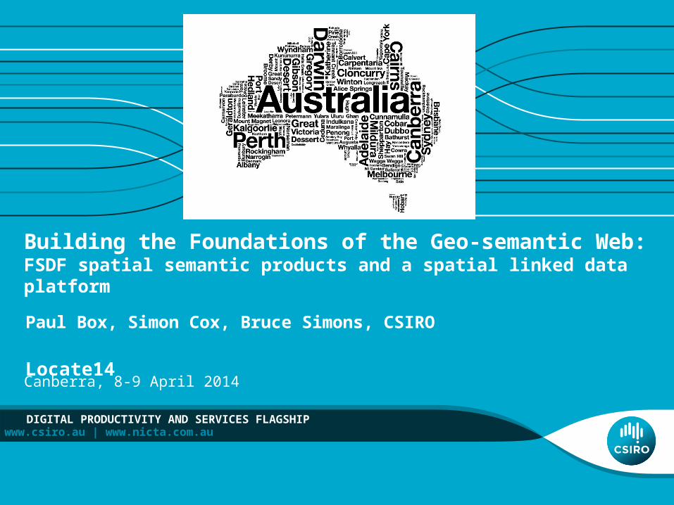
Building the Foundations of the Geo-semantic Web:FSDF spatial semantic products and a spatial linked data platform
Paul Box, Simon Cox, Bruce Simons, CSIRO
Locate14
DIGITAL PRODUCTIVITY AND SERVICES FLAGSHIP
Canberra, 8-9 April 2014

Overview
• The future • Where are we now and what are some of the issues?• What are some of the steps we are taking in the geo-semantic
direction?• FSDF – Admin Boundary Topology Product• SIRF – Spatial Identifier Reference Framework
Thinking Outside the Polygon – Geo-semantics and Spatial Infrastructures | Box2 |

• Australia’s geographic entities in the web of linked data• Stable identifiers for spatial objects• Authoritative data - else people will use non-authoritative sources –
Geonames, OpenStreetMap• Direct access to individual features
• Not acquiring complete datasets• Minimise cost/licensing barriers
The future
Thinking Outside the Polygon – Geo-semantics and Spatial Infrastructures | Box3 |

The present - information silos
System 1
System 2
System 3
System 5 System
4
System n
System 7
$$
$$$
$ $
Discover Access Understand Extract, Transform, Load
Use
Time and effort
Everything Happens Somewhere
Thinking Outside the Polygon – Geo-semantics and Spatial Infrastructures | Box4 |
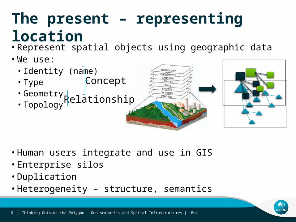
The present – representing location
• Represent spatial objects using geographic data• We use:
• Identity (name) • Type• Geometry • Topology
• Human users integrate and use in GIS• Enterprise silos • Duplication• Heterogeneity – structure, semantics
Concept
Relationship
Thinking Outside the Polygon – Geo-semantics and Spatial Infrastructures | Box5 |

Identity
Thinking Outside the Polygon – Geo-semantics and Spatial Infrastructures | Box6 |

What’s in a name?
Thinking Outside the Polygon – Geo-semantics and Spatial Infrastructures | Box7 |
Tell me about ‘Leichhardt’Which Leichhardt? • Geonames - Australia 22 - Germany 1
Leichhardt in Australia (NSW +QLD)• 4 (52) Australian Gazetteer (GA) NSW, QLD• 14 ASGS (ABS) NSW, VIC, QLD
Leichhardt in NSW2 (9) in NSW Place Names search (GNB NSW)
Feature types• National Gazetteer• Suburb • Parish • Homestead
•ASGS • SA2 (NSW, QLD)• SA3 (NSW)• CED (QLD)• IARE (NSW) • State Suburb (VIC, NSW &
QLD)• Gazetted locality
Leichhardt (Sub) NSW
•GNB• Suburb• Parish

One spatial object - multiple identities and representations
Multiple - names, identifiers, geometries, versions
Geospatial information Statistical information (geospatial dimension)
GNB NSW 32679
Spatial Data Infrastructure (SDI)
Thinking Outside the Polygon – Geo-semantics and Spatial Infrastructures | Box8 |
Geonames 2160386
ABS ASGS SSC11351
GA Aus Gaz NSW3267

Geometry & topology
Thinking Outside the Polygon – Geo-semantics and Spatial Infrastructures | Box9 |

Separating geometry and topology
• Geometric representations – visualization and analysis• Most use cases need topology not geometry -
• Traversing hierarchies - Which Jurisdictions contains Leichhardt LGA• Find connected features - Which rivers are upstream of the Hawkesbury? • Geometry is:
• unreliable for representing topology • inefficient - each user needs to infer topology from geometry • Tool affordance - dependent on GIS software
Thinking Outside the Polygon – Geo-semantics and Spatial Infrastructures | Box10 |

Edge matching between Jurisdictions
LGA boundaries are disjoint
Thinking Outside the Polygon – Geo-semantics and Spatial Infrastructures | Box11 |

Vertical alignment
State > LGA geometries do not align
Thinking Outside the Polygon – Geo-semantics and Spatial Infrastructures | Box12 |

Complexity
1
2Two separate polygons for City of Freemantle (LGA) separated by Swan River
Thinking Outside the Polygon – Geo-semantics and Spatial Infrastructures | Box13 |

Representation ≠ intention
State Upper House Electoral Boundary State Lower House Electoral Boundary
Upper house electorate polygons are contained within lower house electorate polygons
Thinking Outside the Polygon – Geo-semantics and Spatial Infrastructures | Box14 |

What do we need? A web of spatial data
• Unambiguously identify spatial features - URIs • Link spatial features to
• each other • statistics information
• Within spatial information products• encode topological relationships ‘adjacent’, ‘touches’, ‘contains’• Link multiple representation to the same spatial object
• Across spatial information products• Link different identities/geometries representing the same real world feature
– Gazetteer view authoriative State view , ABS statistical view– Same as
• Encode topological relationships across datasets
• Reliably link geometric representation to stats/obs• Enable spatial analysis outside GIS
Thinking Outside the Polygon – Geo-semantics and Spatial Infrastructures | Box15 |
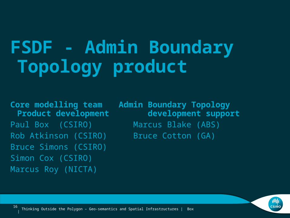
FSDF - Admin Boundary Topology product
Core modelling team Admin Boundary Topology Product development development support
Paul Box (CSIRO) Marcus Blake (ABS)Rob Atkinson (CSIRO) Bruce Cotton (GA)Bruce Simons (CSIRO)Simon Cox (CSIRO)Marcus Roy (NICTA)
Thinking Outside the Polygon – Geo-semantics and Spatial Infrastructures | Box16 |

Presentation title | Presenter name17 |
ANZ Foundation Spatial Data Framework
Making Common Foundation Spatial Data Ubiquitous Across Australia and New Zealand
1. Geocoded Addressing 2. Administrative Boundaries 3. Positioning 4. Place Names 5. Land Parcel and Property 6. Imagery 7. Transport 8. Water 9. Elevation and Depth 10. Land Cover

Modelling process
Data Product Specification
Supply (current state)What data sets are available?
S/T Aggregated
Conceptual Model- Concepts - Relationships
INSPIRE+
Use cases+
Supply data+
Future needs
Link statistical
data
DemandWhat products are required?
Boundary cookie cutter
Traverse spatial hierarchy across
S/T boundary
Product model
What can be done now?
Thinking Outside the Polygon – Geo-semantics and Spatial Infrastructures | Box18 |

Admin Boundary Model – all about identity
Meta-DataVersioningGeometry
Topology
Identity
A Feature exists and has identity
A feature is topologically
related to other features
A feature has versions as it changes over
time
A feature has metadata
A version has geometric
representation(s)
Thinking Outside the Polygon – Geo-semantics and Spatial Infrastructures | Box19 |

Admin Boundary Product Model
Meta-DataVersioningGeometry
Topology
Identity
A Feature exists and has identity
A feature is topologically
related to other features
A feature has versions as it changes over
time
A feature has metadata
A version has geometric
representation(s)
Thinking Outside the Polygon – Geo-semantics and Spatial Infrastructures | Box20 |

• What • Government governance admin units• Identity and Topological relationships - contained/contains, adjacent) (geosparq spatial
relations) • Position in hierarchy• Representative location
• NSW – Leichhardt (LGA) – Albury (LGA)
– Version• Geometry• Relationships
• Spatial • Adjacent to• Contains
• Governance
Admin Boundaries Topology Product
Thinking Outside the Polygon – Geo-semantics and Spatial Infrastructures | Box21 |

• Process• Build topology from geometry• ‘intention filter’ to clean up geometry • Data source
• Developed using PSMA then switched to ABS data• Delivered in standardised formats
• GML (WFS) - geometry• RDF (SIRF API) –identity and relationship
Admin Boundaries Topology Product
Thinking Outside the Polygon – Geo-semantics and Spatial Infrastructures | Box22 |

SDMG - FSDF AB Topology Product - Box23 |

• Al
NSW > Albury City Council
Thinking Outside the Polygon – Geo-semantics and Spatial Infrastructures | Box24 |
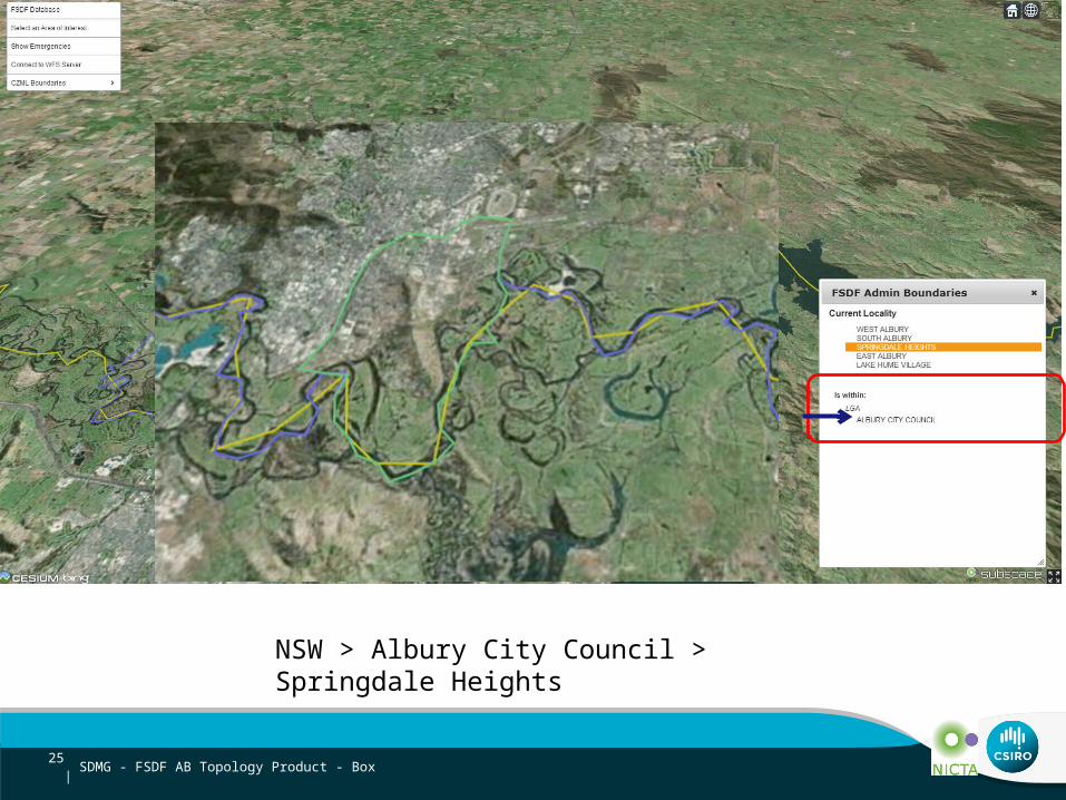
NSW > Albury City Council > Springdale Heights
SDMG - FSDF AB Topology Product - Box25 |

NSW > Albury City Council
Thinking Outside the Polygon – Geo-semantics and Spatial Infrastructures | Box26 |

VIC > Towong Shire
Thinking Outside the Polygon – Geo-semantics and Spatial Infrastructures | Box27 |

STATE_ELECTORAL REGION
NORTHERN VICTORIA SOUTHERN METROPOLITAN
VIC
Thinking Outside the Polygon – Geo-semantics and Spatial Infrastructures | Box28 |

VIC > Southern Metropolitan (Electoral Region)
Thinking Outside the Polygon – Geo-semantics and Spatial Infrastructures | Box29 |

Presentation title | Presenter name
Spatial Identifier Reference Framework - a linked spatial data platform
30 |

Geospatial information Statistical information (Implicitly geospatial)
GNB NSW 32679
Spatial Data Infrastructure (SDI)
Thinking Outside the Polygon – Geo-semantics and Spatial Infrastructures | Box31 |
Geonames 2160386
ABS ASGS SSC11351
GA Aus Gaz NSW3267
Geo-semantics used to bridge existing gaps
Spatial IdentifierReference Framework

How SIRF works
SIRFSpatial
Information
StatisticalInformation User
Linked Data Web
National Spatial Data
Infrastructure
Index identifiers
Agency BTreasury
API
Agency C Welfare
API
Agency AStatistics
API
http://id.data.gov.au/id/AusGaz2010/ NSW56500 Same as
http://linkedgeodata.org/triplify/node26469586 Contains isWithin NSW
Publish URIs
Thinking Outside the Polygon – Geo-semantics and Spatial Infrastructures | Box32 |
Build data network in SIRF

Thinking Outside the Polygon – Geo-semantics and Spatial Infrastructures | Box33 |

Standardised based ISO 19109 Application Schema for conceptual -
modelling UMLISO 19112 – Spatial referencing
OGC WFS
ISO19150-2 - OWL for online resource format
Spatial - Model driven ETL linked data delivery
34 | Spatial Information Modelling Workshop | Paul Box
Presentation title | Presenter name35 |

Presentation title | Presenter name
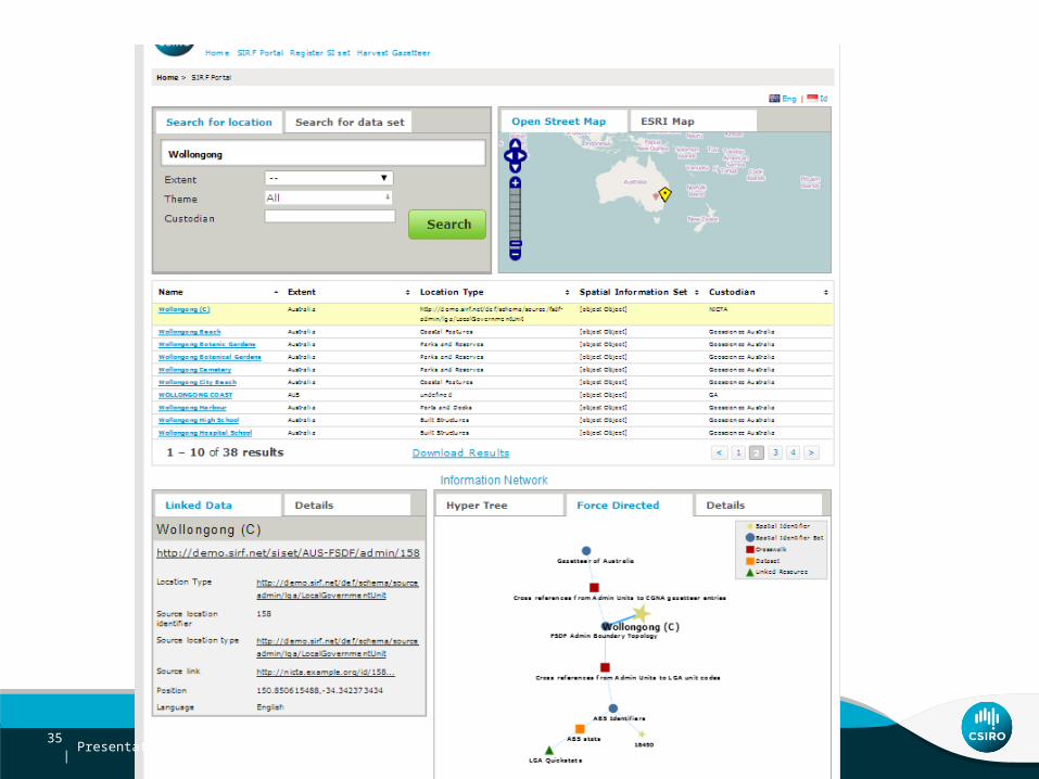
SIRF Data Network
• metadata describing the relationships between Spatial Identifier Sets and related data (RDF)• VOID to describe:
• the available online resources for each dataset• cross-references between spatial sets
36 |

LinksetLinksetSISetSISet SISetSISet
Described using:• SIRF metamodel
Dublin Core• Can be extended with
other description vocabulary as required
Two flavors of links • Identity• links between different identities for the same spatial object • OWL sameAS (could use other predicates)
• Spatial relations:• relationships between different spatial objects• Described using:
• “native” – i.e. lossless, “as declared” in information sources• “geoSPARQL” spatial relations vocabulary (Simple Features subset)• Can be extended to include any relation language e.g. GeoNames
ontology• ad-hoc, but a de facto standard may emerge
A registered Spatial Identifier Set
Description of how two spatial objects are related
Australian National Gazetteer
FSDF Admin Boundary
‘Cross-walks’ between SISets
A registered Spatial Identifier Set

DatasetDataset
Online resourceOnline
resourceDescribed using:•VoiD:TechnicalFeature (linked to IEEE URI templating)• RDF-Data cube planned
An online resource using an SISet to geo-reference information
Described using:• Dublin Core • VoiD• others as needed
Linking statistics to spatial
LinksetLinksetSISetSISet SISetSISetAustralian National Gazetteer
FSDF Admin Boundary
ABS Stats
Census Quickstats
A dataset using an SISet as spatial reference

Summary
• Is it the end of the line for geometry?• New way of thinking about how we create • Identity – model important• Suites of smarter products • Implications
• SIRF - a key component of NSDI in Australia - used to register and link graphs together and spatial to data • Critical role of modelling - multiple KR UML OWL • URI patterns – FSDF requirements to ALDWG
Thinking Outside the Polygon – Geo-semantics and Spatial Infrastructures | Box39 |

More information
• FSDF Admin Boundaries prototype product description – Geospatial services - WFS
https://github.com/NICTA/fsdf-hackfest/wiki/Data-Sets-and-Services– SIRF API https://
github.com/NICTA/fsdf-hackfest/wiki/FSDF-Admin-Boundary-Linked-Data• SIRF
• SIRF goals, research, projects, http://www.sirf.net/about-sirf• APIs http://portal.sirf.net/discover-sirf-technologies/sirf-apis
Thinking Outside the Polygon – Geo-semantics and Spatial Infrastructures | Box40 |

Paul Box
t: +61 2 93253122e: [email protected]: www.csiro.au
DIGITAL PRODUCTIVITY AND SERVICES FLAGSHIP
Thank youCSIRO Digital Productivity and Services Flagship


![Formal Foundations of 3D Geometry to Model Robot Manipulators · tional Geometry and Object Modeling]: Hierarchy and geo-metric transformations Keywords Formal verification, Proof-assistant,](https://img.pdfslide.us/doc/110x75/5f08f78e7e708231d424977c/formal-foundations-of-3d-geometry-to-model-robot-manipulators-tional-geometry-and.jpg)