Embed Size (px)
Citation preview
Complete Streets
in Large Urban Counties
Planners and Engineers Collaborating in
Cuyahoga County
2014 Akron Planning & Zoning Workshop
Friday, May 16, 2014
1
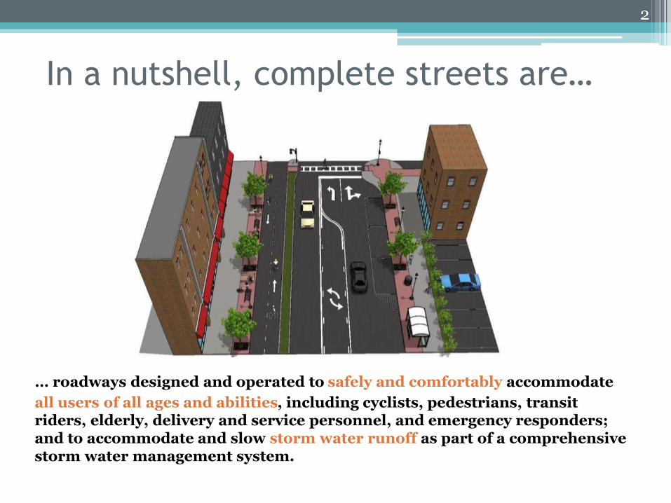
In a nutshell, complete streets are…
… roadways designed and operated to safely and comfortably accommodate
all users of all ages and abilities, including cyclists, pedestrians, transit riders, elderly, delivery and service personnel, and emergency responders; and to accommodate and slow storm water runoff as part of a comprehensive storm water management system.
2
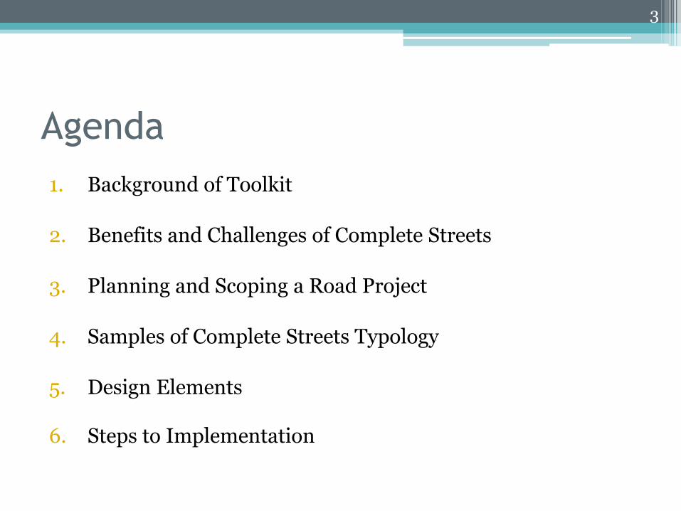
Agenda
1. Background of Toolkit
2. Benefits and Challenges of Complete Streets
3. Planning and Scoping a Road Project
4. Samples of Complete Streets Typology
5. Design Elements
6. Steps to Implementation
3
4
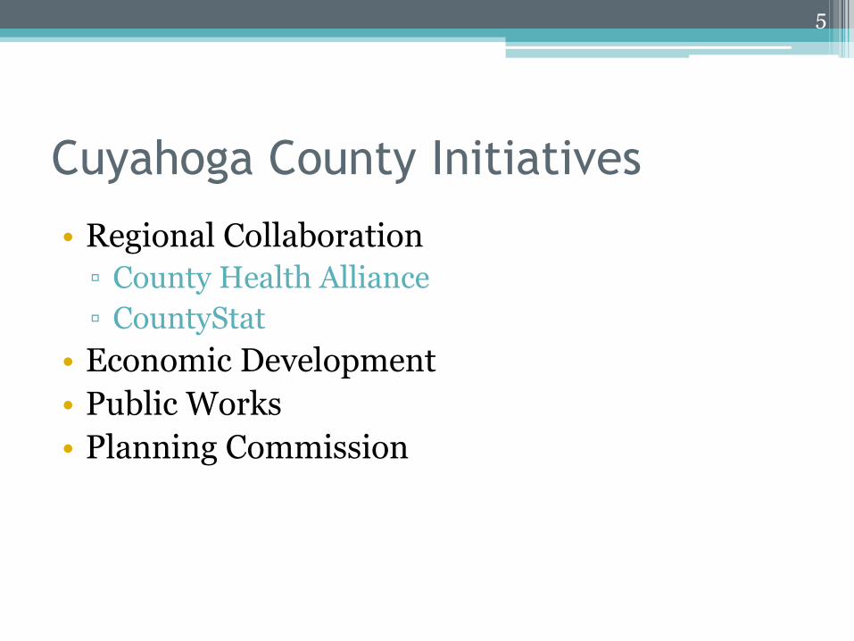
Cuyahoga County Initiatives
• Regional Collaboration
▫ County Health Alliance
▫ CountyStat
• Economic Development
• Public Works
• Planning Commission
5
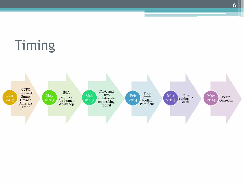
Timing
CCPC received Smart
Growth America
grant
Jan 2013
SGA
Technical Assistance Workshop
May 2013
CCPC and DPW
collaborate on drafting
toolkit
Oct 2013
First draft
toolkit complete
Feb 2014
Fine tuning of
draft
Mar 2014
Begin Outreach
May 2014
6
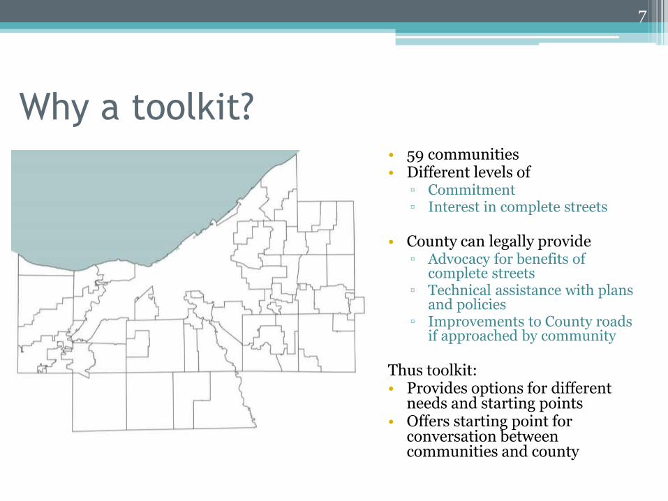
Why a toolkit?• 59 communities • Different levels of
▫ Commitment ▫ Interest in complete streets
• County can legally provide▫ Advocacy for benefits of
complete streets▫ Technical assistance with plans
and policies▫ Improvements to County roads
if approached by community
Thus toolkit:• Provides options for different
needs and starting points• Offers starting point for
conversation between communities and county
7
Principles of toolkit
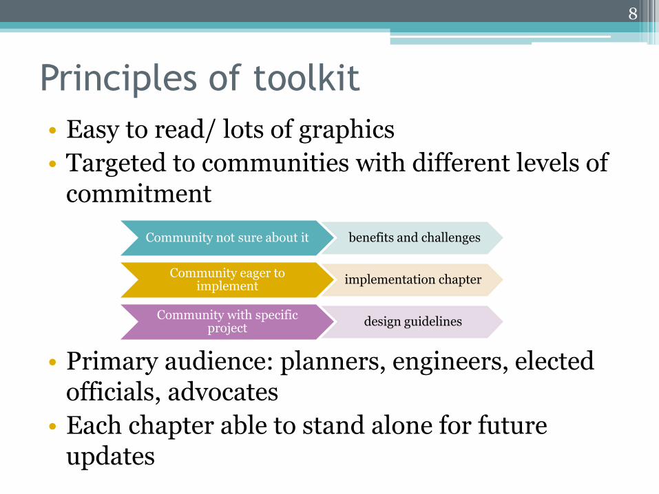
• Easy to read/ lots of graphics
• Targeted to communities with different levels of commitment
• Primary audience: planners, engineers, elected officials, advocates
• Each chapter able to stand alone for future updates
8
Community not sure about it benefits and challenges
Community eager to implement
implementation chapter
Community with specific project
design guidelines
Collaboration of Planning and Public
Works/Engineering• Why collaborate?
▫ Find efficiencies and improve services▫ Land use and transportation go together▫ Maximize resources through short- and long-term planning
• How to collaborate?▫ Develop and coordinate outline based on best practices ▫ Assign chapters for draft document ▫ Hold frequent monthly meetings to provide feedback on current
drafts (3rd iteration of full toolkit)
• Benefits of collaboration?▫ Ability to address broad-based audience▫ Cover complexity of issue to make streets safe for all users▫ Ensure comprehensiveness of content
9
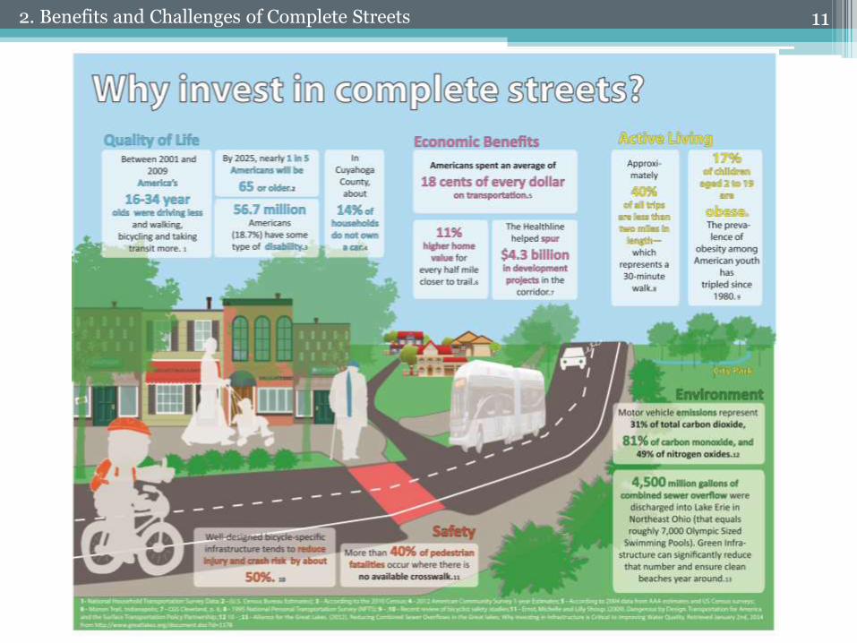
• Why invest in complete streets?
• Right of way challenges
• Cost concerns
• Too far down the road?
10
112. Benefits and Challenges of Complete Streets
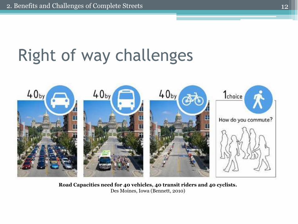
Right of way challenges
12
Road Capacities need for 40 vehicles, 40 transit riders and 40 cyclists. Des Moines, Iowa (Bennett, 2010)
2. Benefits and Challenges of Complete Streets
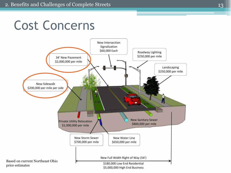
Cost Concerns
132. Benefits and Challenges of Complete Streets
Based on current Northeast Ohio price estimates
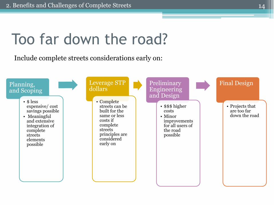
Too far down the road?
Planning, and Scoping
• $ less expensive/ cost savings possible
• Meaningful and extensive integration of complete streets elements possible
Leverage STP dollars
• Complete streets can be built for the same or less costs if complete streets principles are considered early on
Preliminary Engineering and Design
• $$$ higher costs
• Minor improvements for all users of the road possible
Final Design
• Projects that are too far down the road
142. Benefits and Challenges of Complete Streets
Include complete streets considerations early on:
15
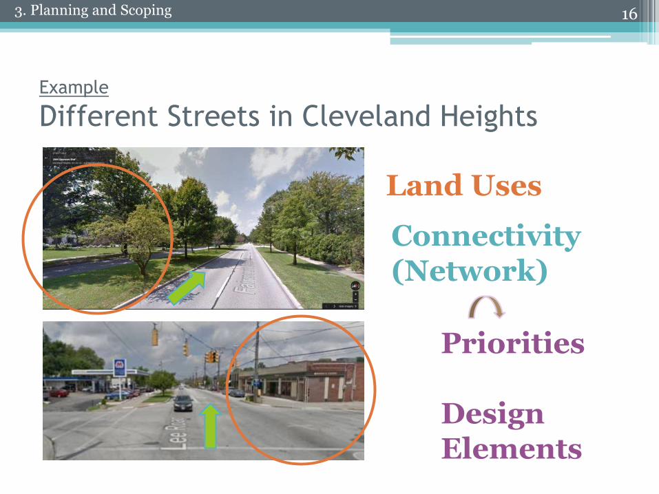
Example
Different Streets in Cleveland Heights
16
Land Uses
Connectivity(Network)
Priorities
DesignElements
3. Planning and Scoping
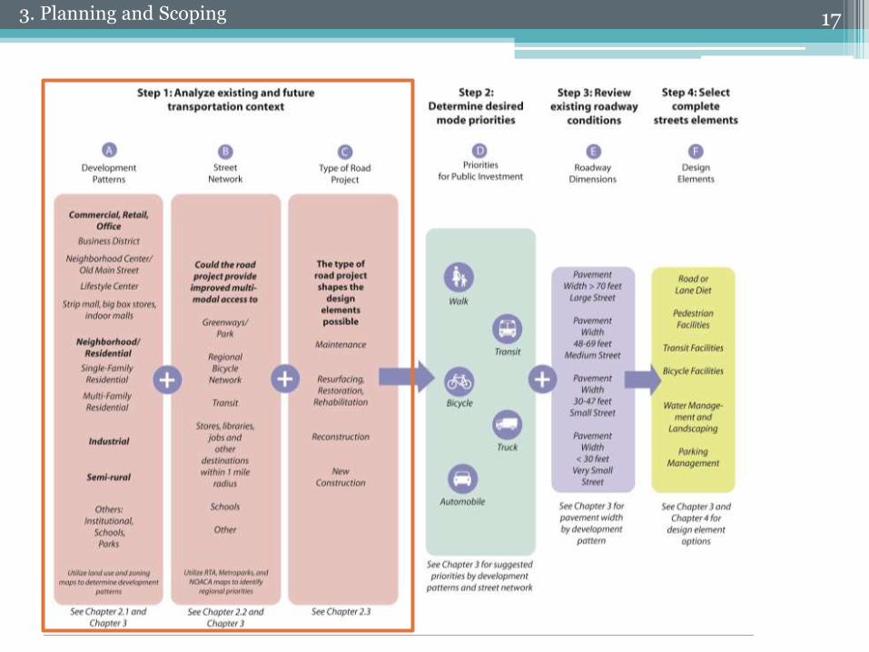
173. Planning and Scoping
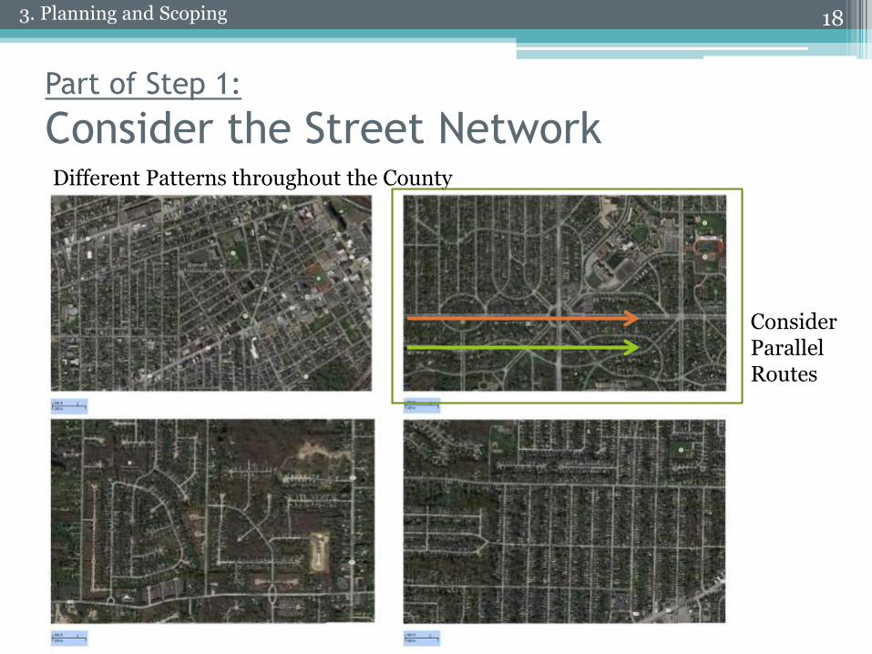
Part of Step 1:
Consider the Street Network
18
ConsiderParallelRoutes
Different Patterns throughout the County
3. Planning and Scoping
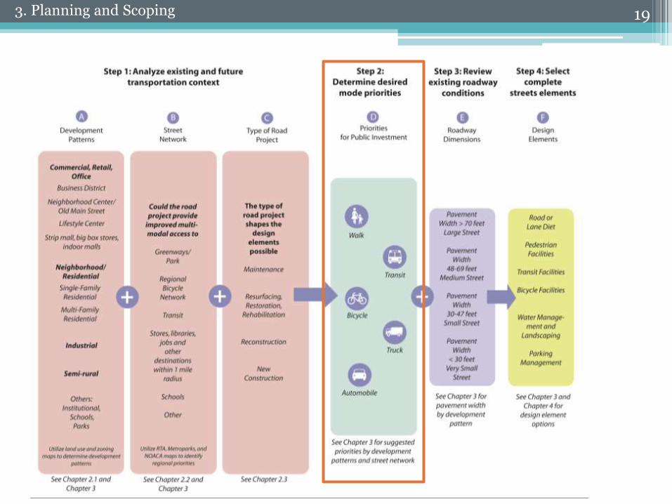
193. Planning and Scoping
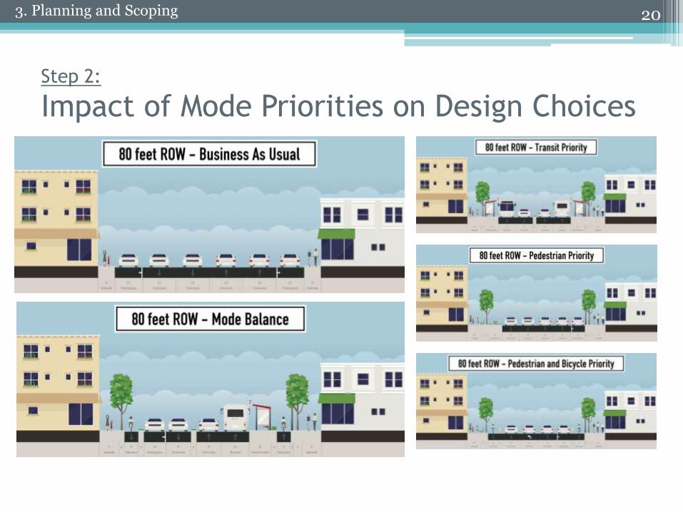
Step 2:
Impact of Mode Priorities on Design Choices
203. Planning and Scoping
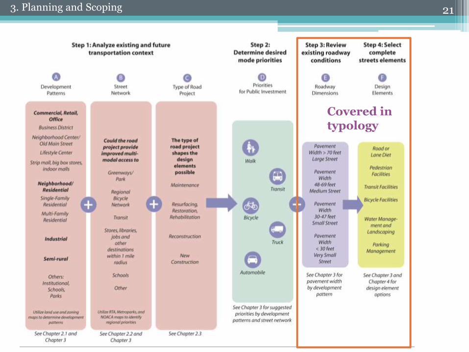
213. Planning and Scoping
Covered intypology
22
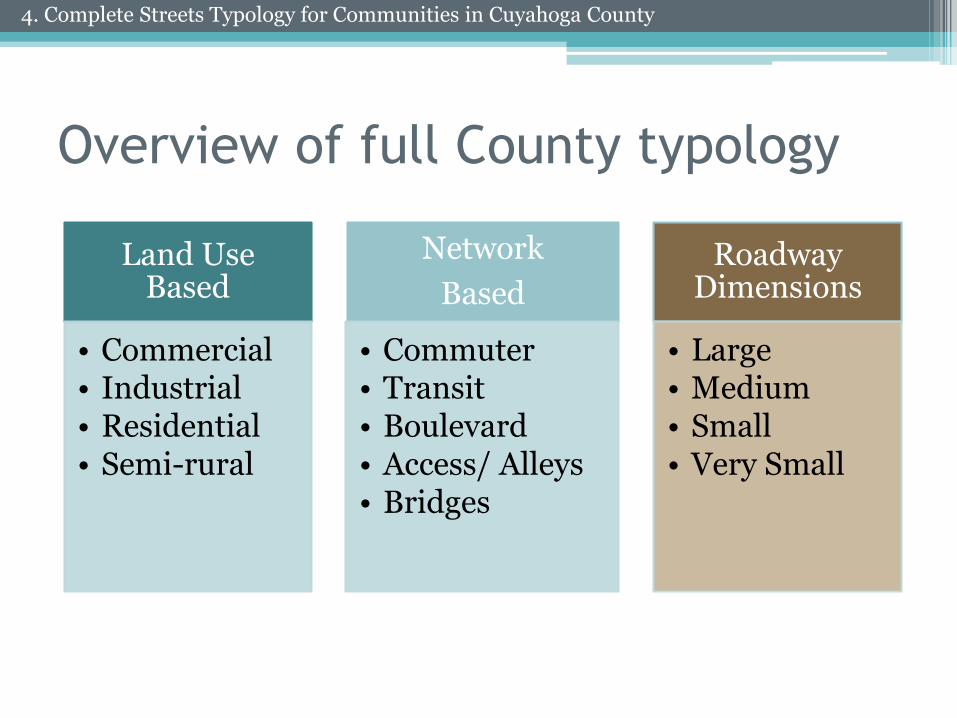
Overview of full County typology
Land Use Based
• Commercial• Industrial• Residential• Semi-rural
Network
Based
• Commuter• Transit• Boulevard• Access/ Alleys• Bridges
Roadway Dimensions
• Large• Medium• Small• Very Small
4. Complete Streets Typology for Communities in Cuyahoga County
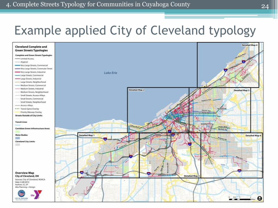
Example applied City of Cleveland typology
244. Complete Streets Typology for Communities in Cuyahoga County
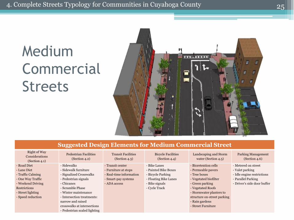
Medium
Commercial
Streets
25
Suggested Design Elements for Medium Commercial StreetRight of Way
Considerations
(Section 4.1)
Pedestrian Facilities
(Section 4.2)
Transit Facilities
(Section 4.3)
Bicycle Facilities
(Section 4.4)
Landscaping and Storm
water (Section 4.5)
Parking Management
(Section 4.6)
- Road Diet
- Lane Diet
- Traffic Calming
- One Way Traffic
- Weekend Driving
Restrictions
- Street lighting
- Speed reduction
- Sidewalks
- Sidewalk furniture
- Signalized Crosswalks
- Pedestrian signals
- Chicanes
- Scramble Phase
- Winter maintenance
- Intersection treatments:
narrow and raised
crosswalks at intersections
- Pedestrian scaled lighting
- Transit center
- Furniture at stops
- Real-time information
- Smart-pay systems
- ADA access
- Bike Lanes
- Painted Bike Boxes
- Bicycle Parking
- Floating Bike Lanes
- Bike signals
- Cycle Track
- Bioretention cells
- Permeable pavers
- Tree boxes
- Vegetated biofilter
- Green parking
- Vegetated Roofs
- Stormwater planters to
structure on-street parking
- Rain gardens
- Street Furniture
- Metered on street
- Valet parking
- Idle engine restrictions
- Parallel Parking
- Driver’s side door buffer
4. Complete Streets Typology for Communities in Cuyahoga County
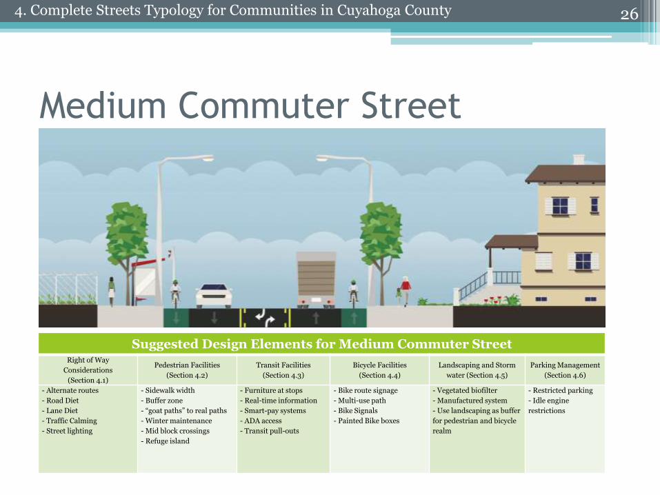
Medium Commuter Street
26
Suggested Design Elements for Medium Commuter StreetRight of Way
Considerations
(Section 4.1)
Pedestrian Facilities
(Section 4.2)
Transit Facilities
(Section 4.3)
Bicycle Facilities
(Section 4.4)
Landscaping and Storm
water (Section 4.5)
Parking Management
(Section 4.6)
- Alternate routes
- Road Diet
- Lane Diet
- Traffic Calming
- Street lighting
- Sidewalk width
- Buffer zone
- “goat paths” to real paths
- Winter maintenance
- Mid block crossings
- Refuge island
- Furniture at stops
- Real-time information
- Smart-pay systems
- ADA access
- Transit pull-outs
- Bike route signage
- Multi-use path
- Bike Signals
- Painted Bike boxes
- Vegetated biofilter
- Manufactured system
- Use landscaping as buffer
for pedestrian and bicycle
realm
- Restricted parking
- Idle engine
restrictions
4. Complete Streets Typology for Communities in Cuyahoga County
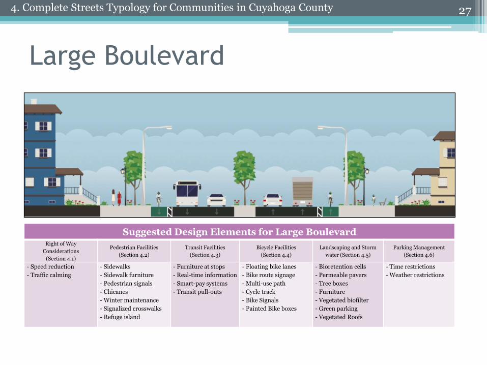
Large Boulevard
27
Suggested Design Elements for Large BoulevardRight of Way
Considerations
(Section 4.1)
Pedestrian Facilities
(Section 4.2)
Transit Facilities
(Section 4.3)
Bicycle Facilities
(Section 4.4)
Landscaping and Storm
water (Section 4.5)
Parking Management
(Section 4.6)
- Speed reduction
- Traffic calming
- Sidewalks
- Sidewalk furniture
- Pedestrian signals
- Chicanes
- Winter maintenance
- Signalized crosswalks
- Refuge island
- Furniture at stops
- Real-time information
- Smart-pay systems
- Transit pull-outs
- Floating bike lanes
- Bike route signage
- Multi-use path
- Cycle track
- Bike Signals
- Painted Bike boxes
- Bioretention cells
- Permeable pavers
- Tree boxes
- Furniture
- Vegetated biofilter
- Green parking
- Vegetated Roofs
- Time restrictions
- Weather restrictions
4. Complete Streets Typology for Communities in Cuyahoga County
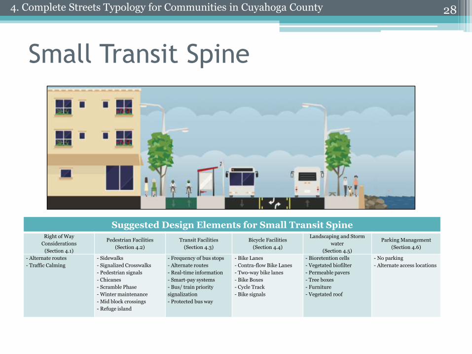
Small Transit Spine
28
Suggested Design Elements for Small Transit SpineRight of Way
Considerations
(Section 4.1)
Pedestrian Facilities
(Section 4.2)
Transit Facilities
(Section 4.3)
Bicycle Facilities
(Section 4.4)
Landscaping and Storm
water
(Section 4.5)
Parking Management
(Section 4.6)
- Alternate routes
- Traffic Calming
- Sidewalks
- Signalized Crosswalks
- Pedestrian signals
- Chicanes
- Scramble Phase
- Winter maintenance
- Mid block crossings
- Refuge island
- Frequency of bus stops
- Alternate routes
- Real-time information
- Smart-pay systems
- Bus/ train priority
signalization
- Protected bus way
- Bike Lanes
- Contra-flow Bike Lanes
- Two-way bike lanes
- Bike Boxes
- Cycle Track
- Bike signals
- Bioretention cells
- Vegetated biofilter
- Permeable pavers
- Tree boxes
- Furniture
- Vegetated roof
- No parking
- Alternate access locations
4. Complete Streets Typology for Communities in Cuyahoga County
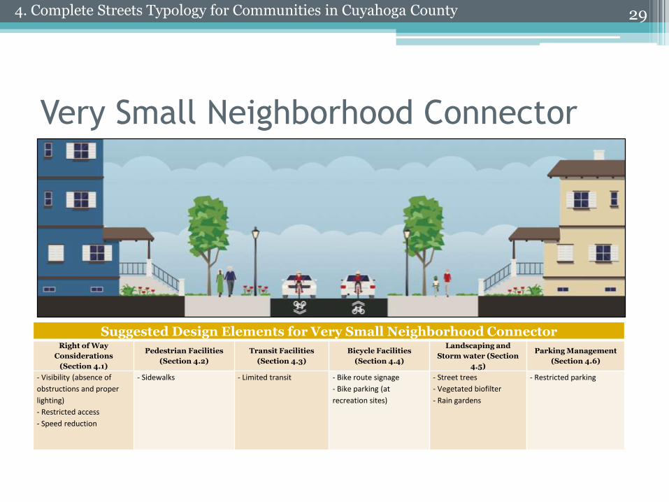
Very Small Neighborhood Connector
29
Suggested Design Elements for Very Small Neighborhood ConnectorRight of Way
Considerations
(Section 4.1)
Pedestrian Facilities
(Section 4.2)
Transit Facilities
(Section 4.3)
Bicycle Facilities
(Section 4.4)
Landscaping and
Storm water (Section
4.5)
Parking Management
(Section 4.6)
- Visibility (absence of
obstructions and proper
lighting)
- Restricted access
- Speed reduction
- Sidewalks - Limited transit - Bike route signage
- Bike parking (at
recreation sites)
- Street trees
- Vegetated biofilter
- Rain gardens
- Restricted parking
4. Complete Streets Typology for Communities in Cuyahoga County
• Right of Way
• Pedestrian Facilities
• Transit Facilities
• Bicycle Facilities
• Water Management
30
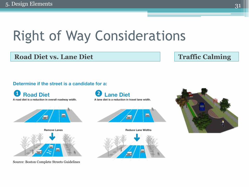
Right of Way Considerations
Traffic CalmingRoad Diet vs. Lane Diet
31
Source: Boston Complete Streets Guidelines
5. Design Elements
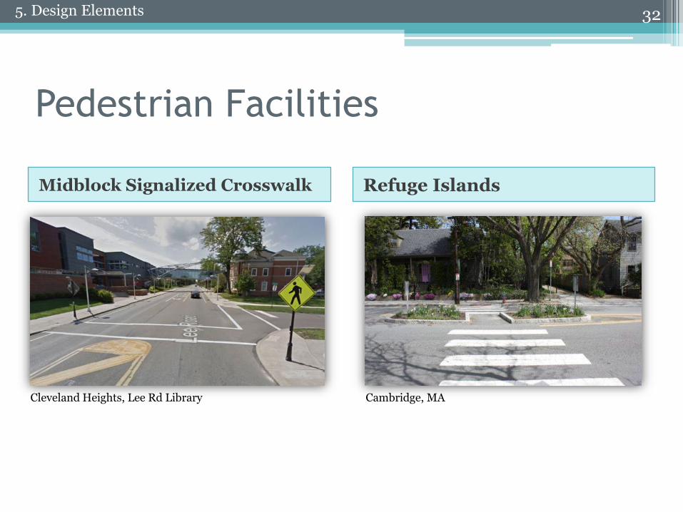
Pedestrian Facilities
Midblock Signalized Crosswalk Refuge Islands
325. Design Elements
Cleveland Heights, Lee Rd Library Cambridge, MA
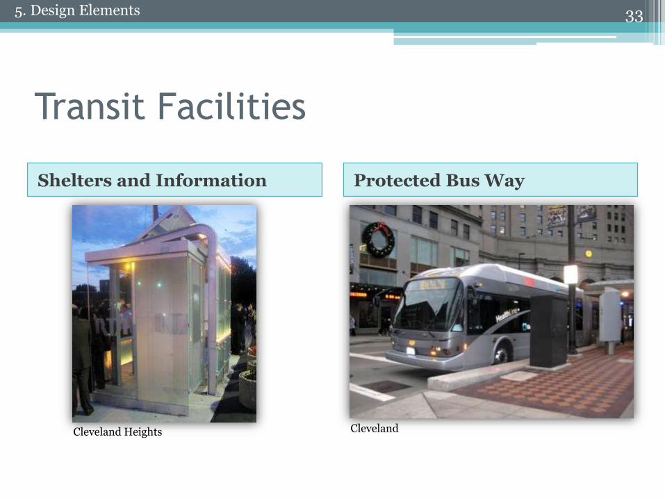
Transit Facilities
Shelters and Information Protected Bus Way
335. Design Elements
Cleveland Heights Cleveland
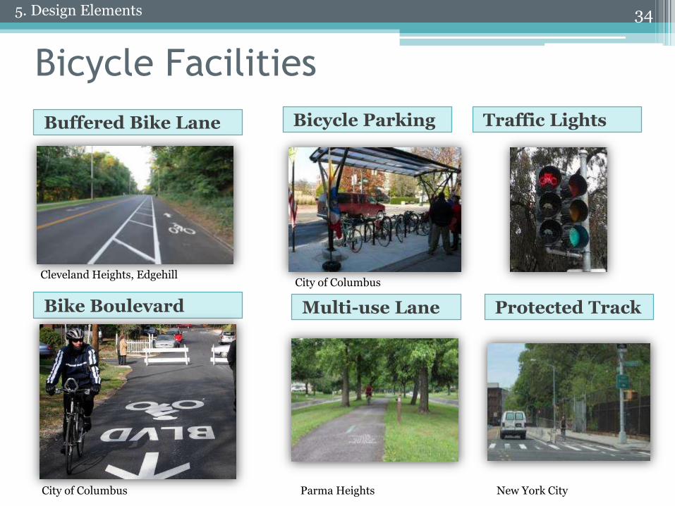
Bicycle Facilities
Buffered Bike Lane
Bike Boulevard
34
Bicycle Parking Traffic Lights
Multi-use Lane Protected Track
5. Design Elements
City of Columbus
City of Columbus
Cleveland Heights, Edgehill
Parma Heights New York City
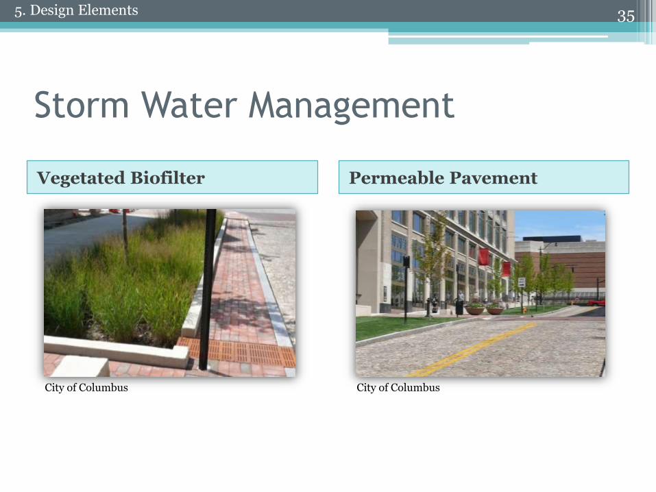
Storm Water Management
Vegetated Biofilter Permeable Pavement
355. Design Elements
City of Columbus City of Columbus
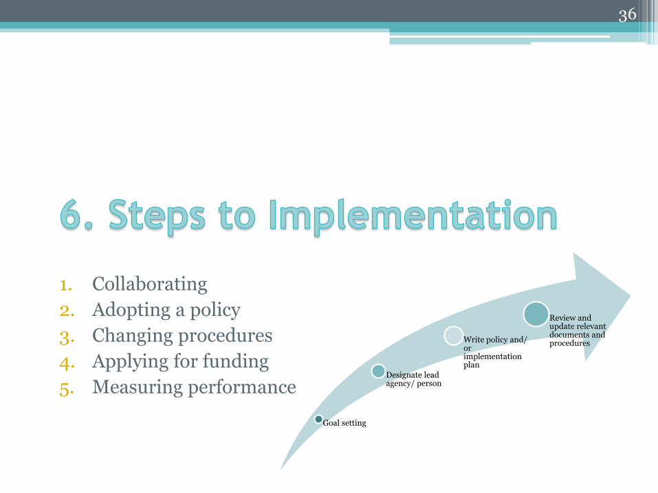
1. Collaborating
2. Adopting a policy
3. Changing procedures
4. Applying for funding
5. Measuring performance
36
Goal setting
Designate lead agency/ person
Write policy and/ or implementation plan
Review and update relevant documents and procedures
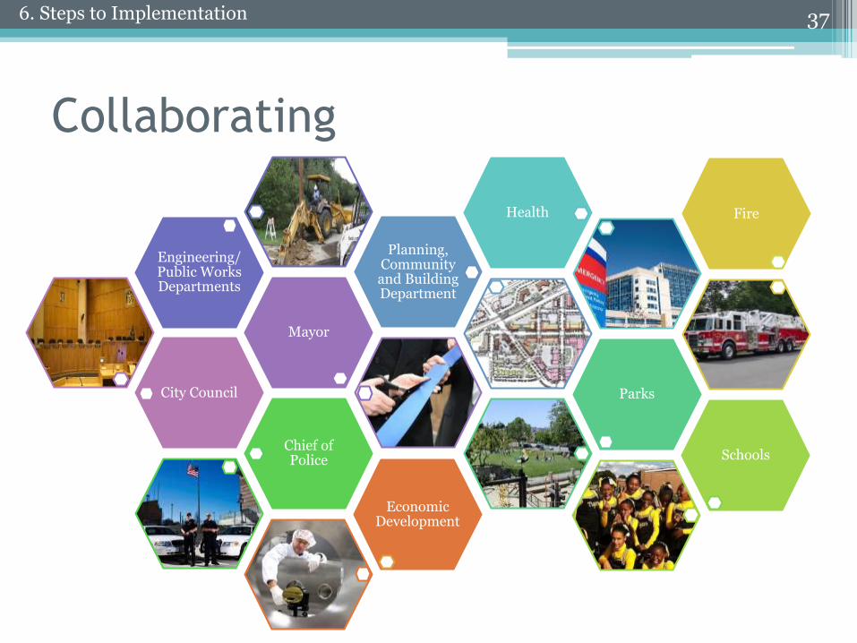
Collaborating
37
City Council
Mayor
Engineering/ Public Works Departments
Planning, Community and Building Department
Health
Parks
Chief of Police Schools
Fire
Economic Development
6. Steps to Implementation
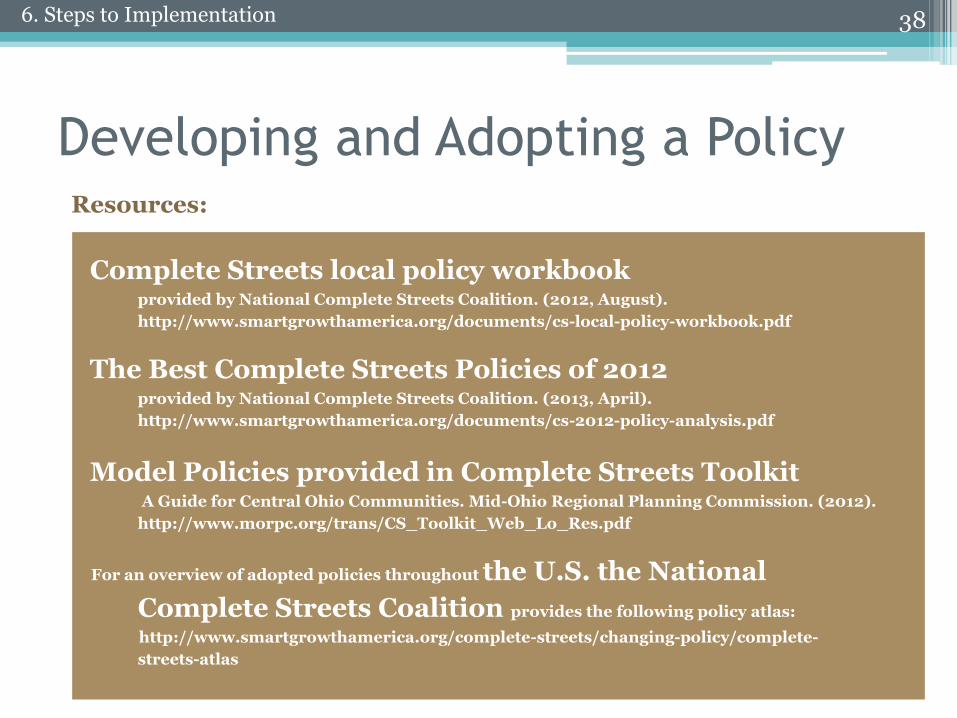
Developing and Adopting a Policy
Complete Streets local policy workbookprovided by National Complete Streets Coalition. (2012, August).
http://www.smartgrowthamerica.org/documents/cs-local-policy-workbook.pdf
The Best Complete Streets Policies of 2012 provided by National Complete Streets Coalition. (2013, April).
http://www.smartgrowthamerica.org/documents/cs-2012-policy-analysis.pdf
Model Policies provided in Complete Streets ToolkitA Guide for Central Ohio Communities. Mid-Ohio Regional Planning Commission. (2012).
http://www.morpc.org/trans/CS_Toolkit_Web_Lo_Res.pdf
For an overview of adopted policies throughout the U.S. the National
Complete Streets Coalition provides the following policy atlas:
http://www.smartgrowthamerica.org/complete-streets/changing-policy/complete-
streets-atlas
38
Resources:
6. Steps to Implementation
Developing and Adopting a Policy
39
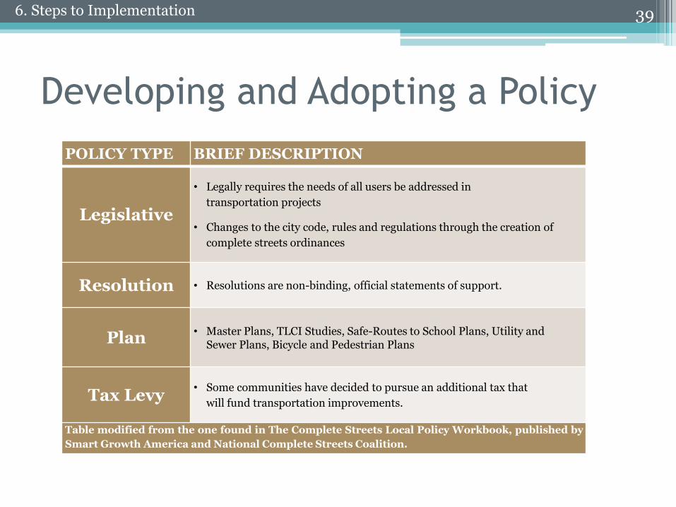
POLICY TYPE BRIEF DESCRIPTION
Legislative
• Legally requires the needs of all users be addressed in
transportation projects
• Changes to the city code, rules and regulations through the creation of
complete streets ordinances
Resolution • Resolutions are non-binding, official statements of support.
Plan• Master Plans, TLCI Studies, Safe-Routes to School Plans, Utility and
Sewer Plans, Bicycle and Pedestrian Plans
Tax Levy• Some communities have decided to pursue an additional tax that
will fund transportation improvements.
Table modified from the one found in The Complete Streets Local Policy Workbook, published by
Smart Growth America and National Complete Streets Coalition.
6. Steps to Implementation
Developing and Adopting a Policy
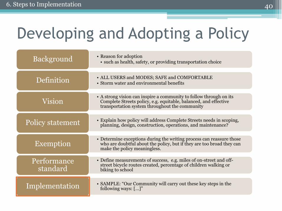
• Reason for adoption• such as health, safety, or providing transportation choiceBackground
• ALL USERS and MODES; SAFE and COMFORTABLE• Storm water and environmental benefitsDefinition
• A strong vision can inspire a community to follow through on its Complete Streets policy, e.g. equitable, balanced, and effective transportation system throughout the community
Vision
• Explain how policy will address Complete Streets needs in scoping, planning, design, construction, operations, and maintenance?Policy statement
• Determine exceptions during the writing process can reassure those who are doubtful about the policy, but if they are too broad they can make the policy meaningless.
Exemption
• Define measurements of success, e.g. miles of on-street and off-street bicycle routes created, percentage of children walking or biking to school
Performance standard
• SAMPLE: “Our Community will carry out these key steps in the following ways: […]”Implementation
406. Steps to Implementation
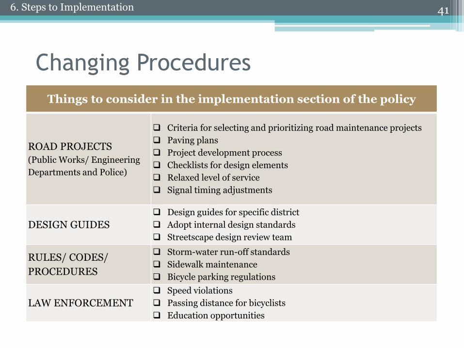
Changing Procedures
41
Things to consider in the implementation section of the policy
ROAD PROJECTS
(Public Works/ Engineering
Departments and Police)
Criteria for selecting and prioritizing road maintenance projects
Paving plans
Project development process
Checklists for design elements
Relaxed level of service
Signal timing adjustments
DESIGN GUIDES
Design guides for specific district
Adopt internal design standards
Streetscape design review team
RULES/ CODES/
PROCEDURES
Storm-water run-off standards
Sidewalk maintenance
Bicycle parking regulations
LAW ENFORCEMENT
Speed violations
Passing distance for bicyclists
Education opportunities
6. Steps to Implementation

42
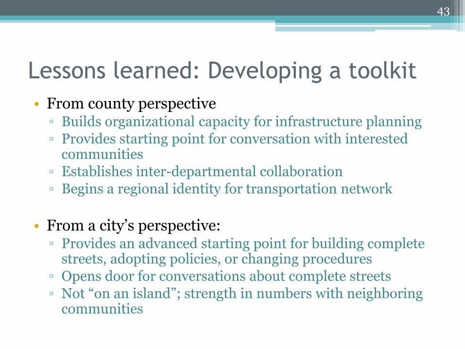
Lessons learned: Developing a toolkit
• From county perspective▫ Builds organizational capacity for infrastructure planning
▫ Provides starting point for conversation with interested communities
▫ Establishes inter-departmental collaboration
▫ Begins a regional identity for transportation network
• From a city’s perspective:▫ Provides an advanced starting point for building complete
streets, adopting policies, or changing procedures
▫ Opens door for conversations about complete streets
▫ Not “on an island”; strength in numbers with neighboring communities
43
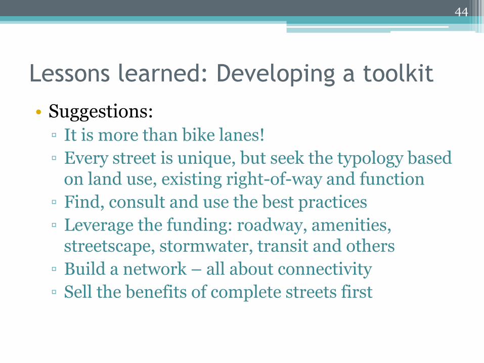
Lessons learned: Developing a toolkit
• Suggestions:
▫ It is more than bike lanes!
▫ Every street is unique, but seek the typology based on land use, existing right-of-way and function
▫ Find, consult and use the best practices
▫ Leverage the funding: roadway, amenities, streetscape, stormwater, transit and others
▫ Build a network – all about connectivity
▫ Sell the benefits of complete streets first
44
Questions and Answers
45
Jennifer Scofield, MA, CHES
Interim Director of Regional Collaboration
Office of Cuyahoga County Executive Ed FitzGerald
216-698-3022
Glenn Coyne, FAICP
Executive Director
Cuyahoga County Planning Commission
216-443-3700
46
Project Team Complete Streets Toolkit:
Office of County Executive Ed FitzGerald: Jennifer Scofield
Cuyahoga County Planning Commission: Glenn Coyne (Executive Director), Deborah Riemann (project coordinator), Kristin Hopkins, Alison Ball, Meghan Chaney, Michael Melko, Claire Kilbane, Dan Meaney, Robin Watkins
Cuyahoga County Department of Public Works: Bonnie Teeuwen(Director of Public Works), Gayle Lewin (project coordinator), Stan Kosilesky, David Marquard
Technical Assistance: Jacob VanSickle (Bike Cleveland), Smart Growth America