Embed Size (px)
Citation preview

Transboundary Aquifer Mapping and Management in Africa:An Ongoing Process
Yvan Altchenko & Karen G. Villholth
Phot
o by
K. V
illho
lth /
IWM
I
Groundwater resource in Africa
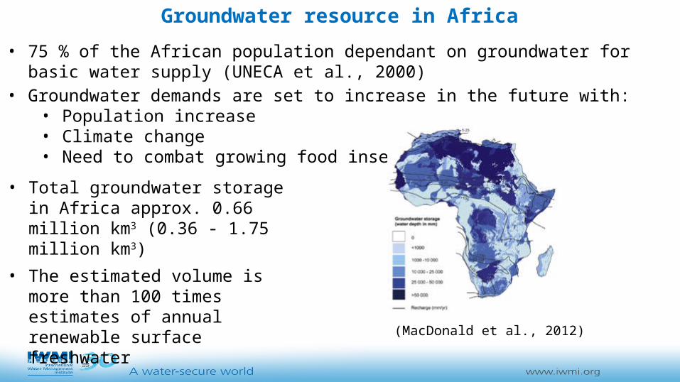
• Total groundwater storage in Africa approx. 0.66 million km3 (0.36 - 1.75 million km3)
• The estimated volume is more than 100 times estimates of annual renewable surface freshwater
• Not all is available for abstraction (MacDonald et al., 2012)
• 75 % of the African population dependant on groundwater for basic water supply (UNECA et al., 2000)
• Groundwater demands are set to increase in the future with:• Population increase• Climate change• Need to combat growing food insecurity

• Water and land use, and groundwater (GW) development in one state may affect GW resources in another, and GW impacts may not be obvious without joint monitoring
• Surface Water (SW) issues involve, or even have root in, GW related activities and impacts
• Many transboundary terrestrial and aquatic ecosystems are GW-dependent and cannot be properly managed without knowledge on the GW resources
• Equitable, informed, and mutually agreed development of GW and land use can prevent tension
• Equitable and informed GW development and management has a lot to do with achieving MDGs/SDGs: poverty alleviation, food security, climate change adaptation, and drought mitigation
Why focus on groundwater management in a transboundary sense?

What is a Transboundary Aquifer (TBA)?
Where to find a TBA?
(UNESCO/ISARM, 2001)
DEFINITIONA transboundary aquifer or a transboundary aquifer system (TBA) is defined as “an aquifer or aquifer system, parts of which are situated in different States” (UN International Law Commission - UNILC)
BUTin practical identification and verification of a TBA, the spatial delimitation, hydrogeological similarity, recharge and discharge mechanisms and zones, and significant hydraulic connectivity between the national compartments of the TBA are important and should be established and agreed upon between aquifer-sharing states

Evolution of the number of TBAs in Africa
WHYMAP(2006) IGRAC (2009) IGRAC (2012)AFRICAN REGION UNESCO
2004WHYMAP
2006IGRAC 2009
IGRAC 2012
North Africa 6 6 7 9
Western and Central Africa(except countries in SADC) 9 9 9 22
Eastern Africa(except countries in SADC) 5 5 5 6
Southern Africa(SADC countries) 18 20 20 34
TOTAL 38 40 41 71

Evolution of the number of TBAs in Africa
IGRAC (2015)IGRAC (2014)IWMI (2013)AFRICAN REGION UNESCO
2004WHYMAP
2006IGRAC 2009
IGRAC 2012
IWMI 2013
IGRAC 2014
IGRAC 2015
North Africa 6 6 7 9 15 15 12
Western and Central Africa(except countries in SADC) 9 9 9 22 22 26 18
Eastern Africa(except countries in SADC) 5 5 5 6 8 8 8
Southern Africa(SADC countries) 18 20 20 34 35 34 34
TOTAL 38 40 41 71 80 83 72

A new nomenclature proposedbased on 3 geographic regions
zones

80 transboundary aquifers(83 transboundary aquifers – IGRAC 2014)(72 transboundary aquifers – IGRAC 2015)
42 % of area of Africa
30 % of African population
63 international river/lake basins
21 international water basin organisations
The TBAs map of Africa

72 transboundary aquifers
Some TBAs identified in Central Africa and North Africa have been removed
Some identified TBAs have been joined into one TBA in Northern Africa, Western and Central Africa, and Southern Africa
The IGRAC 2015 TBAs map

TBA Information table

TBAs management Transboundary water resources management has been totally dominated by a surface water
focus, practically ignoring the interconnections with surface water
Data on TBAs reside in national institutions, transboundary River/Lake Basin Organisations (R/LBOs) and other international organisations, e.g. IGRAC
Two options to adopt groundwater into international agreements:• The 1997 United Nations WaterCourses Convention (UNWCC), which defines GW as a
physical extension of a surface water body within the watercourse spatial domain. The treaty has been ratified by 35 states and entered into force since 17 August 2014.
BUT groundwater boundaries don’t necessary match with river basin boundary
• The 19 drafts articles on the Law of Transboundary Aquifers presented in 2008BUT still not adopted by the UN General Assembly, which however promotes bilateral or regional agreements between the countries in the interim, e.g. Guarani Aquifer (South America)
African Ministers’ Council on Water (AMCOW) promotes TBAs management by R/LBOs

International basins
TBAs
TBAs management by R/LBOs ?
•Argument for:
Their present integral role as custodians for shared river and lake basin resources
•Counterargument:• Poor human capacity, financing and
authority• The geographical location of the TBAs
doesn’t necessary match with the spatial mandate of the R/LBOs

• 3 groundwater explicit agreements:• Nubian Sandstone aquifer system (AFNE12) from 2000• North Western Sahara aquifer system (AFNE16) from 2002• Irhazer – Iullemeden (AFWC15) from 2009
• SADC is taking a frontrunner position in TBAs management, next to Northern Arica:• Protocol on Shared Watercourses revised in 2000 and hinged on the UNWCC• Regional Strategic Action Plan for integrated water resources management explicitly
addressing TBAs management• Work in progress on two TBAs:
• AF5 (Stampriet)• AF7 (Ramotswa)
Current TBAs management in Africa

• TBAs identification and delineation is an on-going process
• TBAs management is expected to raise the profile of neglected local/national GW resources management, especially in low development countries
• TBAs management can reduce future conflicts linked with GW development
• BUT there is a need to:• understand flow processes and interactions with surface water
• develop collaboration and knowledge sharing between the riparian countries
• reformulate and adapt the legal basis of R/LBOs to include explicit mentioning of GW (not as a new and separate domain)
• design flexible and hybrid institutional models built on the present customary approach of making the R/LBOs responsible
Conclusions

References
• Altchenko Y. and Villholth K.G. (2013) Transboundary aquifer mapping and management in Africa: a harmonised approach. Hydrogeol. J., doi: 10.1007/s10040-013-1002-3
• MacDonald A, Bonsor H, Dochartaigh B, Taylor R (2012) Quantitative maps of groundwater resources in Africa. Environ. Res. Lett. 7, doi:10.1088/1748-9326/7/2/024009
• United Nations Economic Commission for Africa (UNECA), African Union (AU), and African Development Bank (AfDB) (2000) The Africa water vision for 2025: equitable and sustainable use of water for socioeconomic development, 28 pp.
• IGRAC http://www.un-igrac.org

Phot
o by
X. C
ai /
IWM
I
Phot
o by
K. V
illho
lth /
IWM
I
Phot
o by
K. V
illho
lth /
IWM
I
Phot
o by
Y. A
ltche
nko
/ IW
MI
http://www.slideshare.net/IWMI_media
Thank YouMerci