Embed Size (px)
Citation preview

Photo: R. Hancock
Sea Level Rise & the Conservation of Wetlands: Issues and Opportunities for Coastal Planning in Rhode Island.
Incorporating SLAMM Maps and Recommendation into Local Plans
Chelsea Siefert, RI Statewide Planning Program Teresa Crean, URI Coastal Resources Center /
RI Sea Grant

Incorporating SLAMM into Local Plans
• SLAMM and the municipal Comprehensive Plan
• Comprehensive Plan Guidebook – Natural Resources Element – Open Space and Recreation – Natural Hazards requirement (2016 deadline!)
• RISPP Technical Assistance • State programs for municipal implementation


Data Available to RI Municipalities
• CRMC website – SLAMM map PDFs
• RIGIS – SLAMM map data will be made available through RIGIS in 2015
• Statewide viewers – Interactive Map Servers (IMS), arcgis.com “Rhode Island Inundation Surfaces”

10 Sept 2010 Photo: Teresa Crean
Case Study: North Kingstown • Adaptation to Natural Hazards and Climate
Change in North Kingstown, RI • Map Atlas • SLAMM maps • Data analysis • Adaptation strategies • Prioritization • Comprehensive Plan, Goals & Objectives
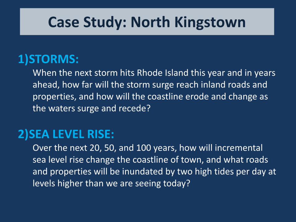
1)STORMS: When the next storm hits Rhode Island this year and in years ahead, how far will the storm surge reach inland roads and properties, and how will the coastline erode and change as the waters surge and recede?
2)SEA LEVEL RISE:
Over the next 20, 50, and 100 years, how will incremental sea level rise change the coastline of town, and what roads and properties will be inundated by two high tides per day at levels higher than we are seeing today?
Case Study: North Kingstown
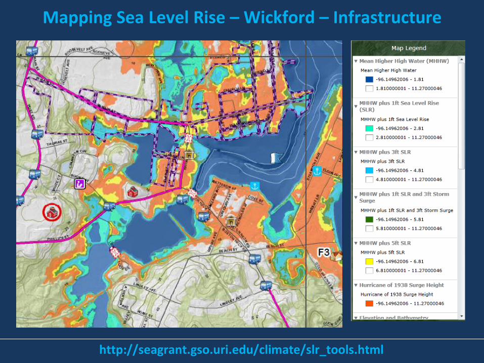
Mapping Sea Level Rise – Wickford – Infrastructure
http://seagrant.gso.uri.edu/climate/slr_tools.html

Local Applications • Regulatory – zoning ordinance and comprehensive plan amendments
• Hazard Mitigation Plan – incorporate and implement actions
• Educate Locally - distribute information to elected officials and homeowners
• Incorporate into town GIS and IMS - more accessible information
• Community Rating System (CRS) impacts – achieve lower rating
• Transportation – ID roads and infrastructure inundated
• State of RI Transportation Improvement Program (TIP) –incorporate into future application
• Capital Improvement Plan (municipal) –infrastructure improvements (i.e sewers, dams, roadways, water)
• Building Code - work with RIBA and CRMC to modify code in coastal zone
• Open space acquisition – ID/prioritize lands for protection, salt marsh creation

Case Study: North Kingstown


1. Land Use 2. Transportation & Circulation 3. Building Stock 4. Municipal Properties &
Facilities 5. Emergency Management
Facilities 6. Wastewater 7. Stormwater Management 8. Drinking Water 9. Groundwater
10. Wetlands 11. Historic & Cultural Resources 12. Contaminated Sites 13. Open Space, Recreation, & Public
Access 14. Vulnerable Populations 15. Greenhouse Gas Reduction (CO2
Mitigation) 16. Utilities and Other Infrastructure 17. Communications 18. Municipal Operations

Adaptation Strategies: Wetlands

Adaptation Strategies: Wetlands

SLAMM – Wickford Village, Current

SLAMM – Wickford Village, +1 ft

SLAMM – Wickford Village, +3 ft

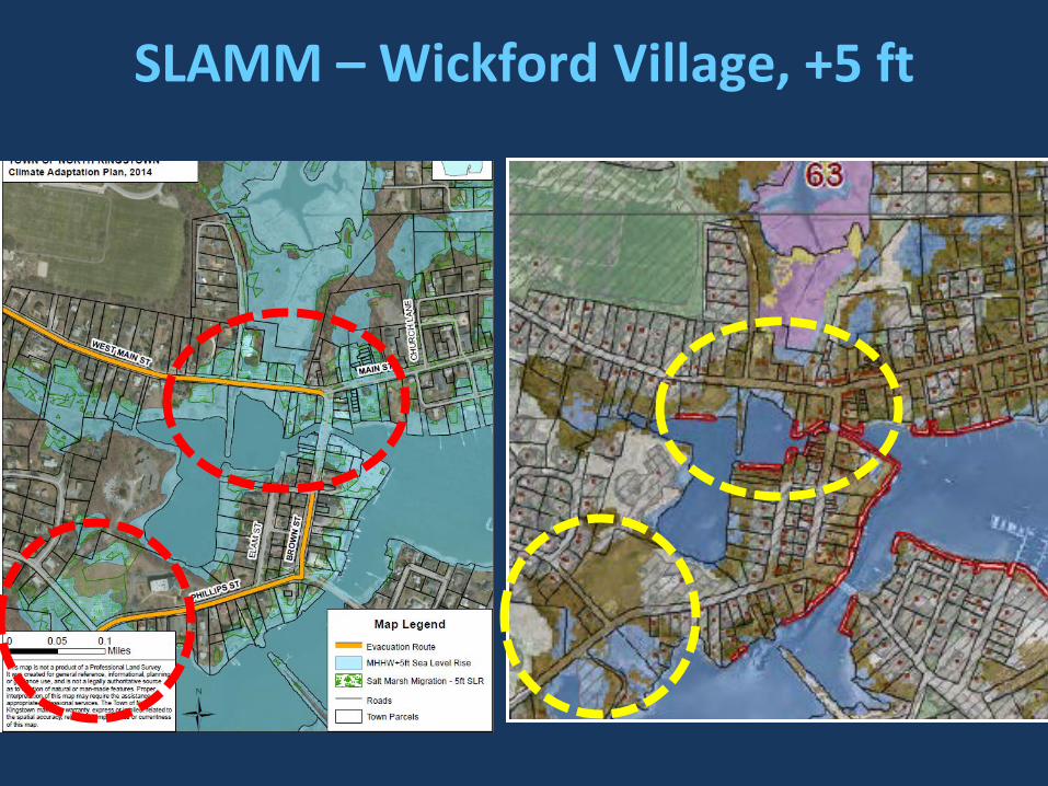
SLAMM – Wickford Village, +5 ft
SLAMM – Wickford Village, +5 ft

SLAMM – Wickford Village, +5 ft

Some thoughts...Local Planning Challenges
• How to incorporate SLAMM into future land use map
• Where should the marsh be “allowed” to migrate? Which areas should be redesigned or managed?
• Begin thinking of wetlands and salt marsh complexes as INFRASTRUCTURE – gray/green solutions
• Identify the “win/wins” and co-benefits – balance of natural resource conservation with protection of lives, infrastructure and property

MARYLAND “Sea Level Rise Overlay”
“The model ordinance proposes revisions to existing floodplain ordinances: (1) To extend the floodplain boundaries to regulate in areas that will become at increasing risk of flooding as sea levels rise, and
(2) To create different sub-districts within the floodplain district to allow local governments to tailor regulations based upon two adaptation goals: ACCOMMODATION and RETREAT/CONSERVATION. dnr.state.md.us/ccs/pdfs/
georgetownclimate.org

FLORIDA “Adaptation Action Area” Inundation mapping and risk assessments revealed the need to focus adaptation improvements in areas of increased risk of inundation due to sea level rise, and the means for directing future funding to these targeted areas. The term Adaptation Action Area (AAA) was created to provide for special designation of these priority planning areas where coastal and tidal flooding placed public and private infrastructure at risk. "Adaptation action area" or "adaptation area" is an optional comprehensive plan designation for areas that experience coastal flooding and that are vulnerable to the related impacts of rising sea levels for the purpose of prioritizing funding for infrastructure needs and adaptation planning. The Adaptation Action Areas White Paper can be found on the Compact website. http://southeastfloridaclimatecompact.org/

Photo: R. Hancock
Sea Level Rise & the Conservation of Wetlands: Issues and Opportunities for Coastal Planning in Rhode Island.
Incorporating SLAMM Maps and Recommendation into Local Plans
Chelsea Siefert, RI Statewide Planning Program Teresa Crean, URI Coastal Resources Center /
RI Sea Grant